Embed Size (px)
Citation preview
B
BB
B
B
B
C
C
C
C
20002
20001
10001
10006
10007
10002
20004
10005
10010
20003
1000410003
10008
10009
447978774476
4476 77 78 4479
5815
14
13
5812 5812
13
14
5815
11° 42'41'40'11° 39'
11° 39' 40' 41' 11° 42'
52° 28'
52° 27'52° 27'
52° 28'
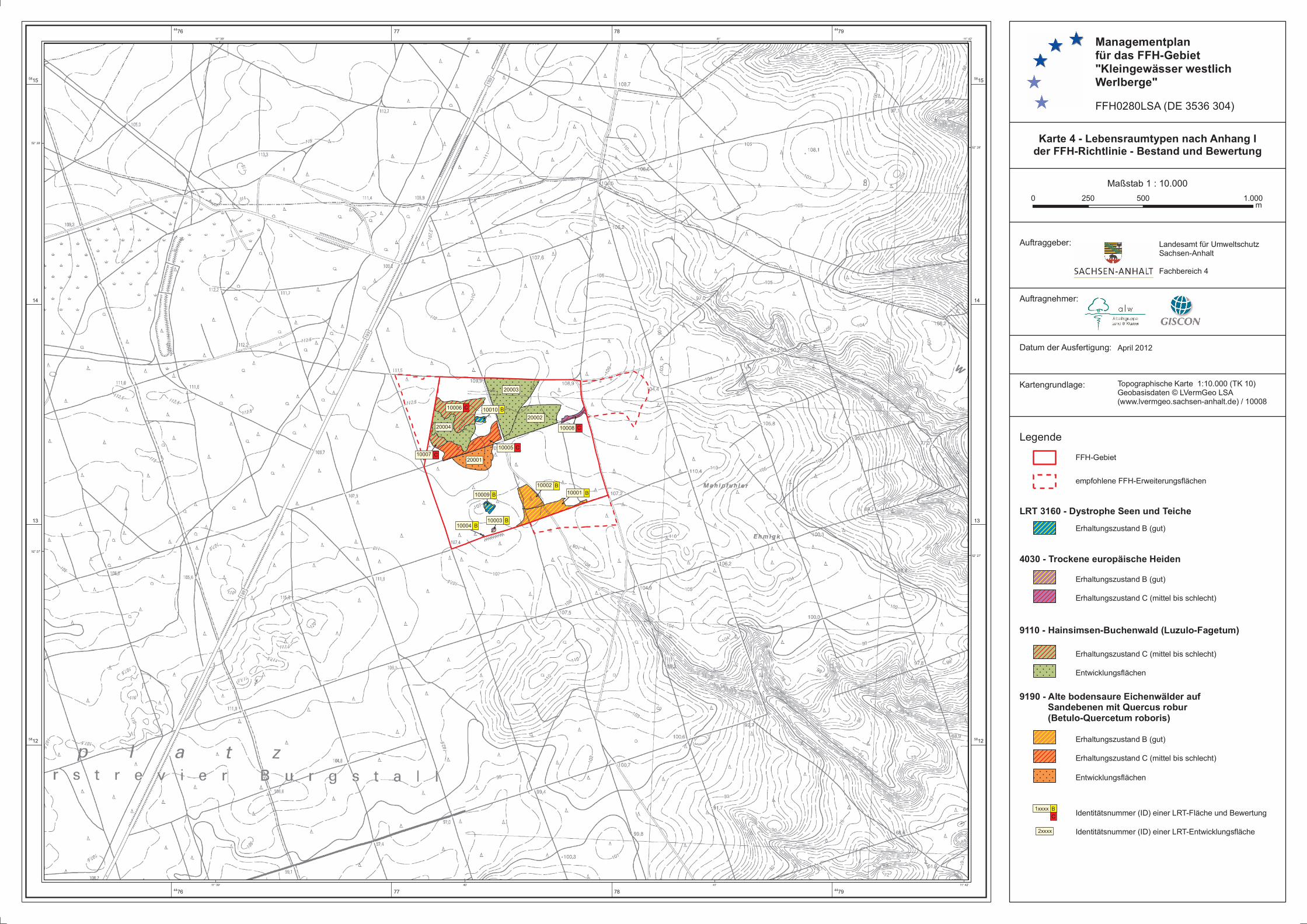
Managementplanfür das FFH-Gebiet"Kleingewässer westlichWerlberge"FFH0280LSA (DE 3536 304)
Maßstab 1 : 10.000
Auftraggeber:
Auftragnehmer:
Landesamt für UmweltschutzSachsen-AnhaltFachbereich 4
Datum der Ausfertigung:
Kartengrundlage:
Karte 4 - Lebensraumtypen nach Anhang Ider FFH-Richtlinie - Bestand und Bewertung
Topographische Karte 1:10.000 (TK 10)Geobasisdaten © LVermGeo LSA(www.lvermgeo.sachsen-anhalt.de) / 10008
April 2012
Legende
empfohlene FFH-Erweiterungsflächen
FFH-Gebiet
Erhaltungszustand B (gut)
Erhaltungszustand B (gut)
LRT 3160 - Dystrophe Seen und Teiche
4030 - Trockene europäische Heiden
9110 - Hainsimsen-Buchenwald (Luzulo-Fagetum)
9190 - Alte bodensaure Eichenwälder auf Sandebenen mit Quercus robur (Betulo-Quercetum roboris)
Identitätsnummer (ID) einer LRT-Fläche und Bewertung
Identitätsnummer (ID) einer LRT-Entwicklungsfläche
Erhaltungszustand C (mittel bis schlecht)
Erhaltungszustand C (mittel bis schlecht)
Entwicklungsflächen
Erhaltungszustand B (gut)
Erhaltungszustand C (mittel bis schlecht)
Entwicklungsflächen
0 500 1.000250 m
2xxxx
1xxxx BC
![Finale 2003 - [Untitled1] · B & & V? &?? b b bbb bbb # # b b b b b b b b b b b c c c c c c c c c c c c c c c c c Bb-Klarinette 1 Bb-Klarinette 2 Horn in F 1 Horn in F 2 Bb-Trompete](https://img.pdfslide.tips/doc/110x75/5ed198800fa647477a71b28d/finale-2003-untitled1-b-v-b-b-bbb-bbb-b-b-b-b-b-b-b.jpg)


![Finale 2005 - [Êxodus]€¦ · b b b b b b b bbb bbb bbb bbb b c c c c c c c c c c c c c c c c..... Requinta (Eb) 1º Clarinete (Bb) 2º Clarinete (Bb) 3º Clarinete (Bb) Sax-Alto](https://img.pdfslide.tips/doc/110x75/5e8db1d8e79ae379b8122648/finale-2005-xodus-b-b-b-b-b-b-b-bbb-bbb-bbb-bbb-b-c-c-c-c-c-c-c-c-c-c-c-c.jpg)
![Finale 2003 - [Delirio Valsa]...bbb b b b b b b b bbb bbb bbb bbb b c c c c c c c c c c c c c c c c c c c c c Flauta (C) Requinta (Eb) I Clarinete (Bb) II Clarinete (Bb) III Clarinete](https://img.pdfslide.tips/doc/110x75/6067de2932f6f32e9c131c68/finale-2003-delirio-valsa-bbb-b-b-b-b-b-b-b-bbb-bbb-bbb-bbb-b-c-c-c-c-c.jpg)


![C C!C!C B]B B¥BlB·BrB¢B®B B¤B~B B BdB·B - Fujitsu...C C!C!C B]B B¥BlB·BrB¢B®B1.3. B 4?" B 1 !ªB1 2 ¸ {AîBpB·B Bt / 0 C C!C!C Ñ!ª(*B1 Ñ " H 0 B BpB·B Bt Ñ!ª o 0](https://img.pdfslide.tips/doc/110x75/60a9b5ef1dcf032ca5305f6d/c-ccc-bb-bblbbrbbb-bbb-b-bdbb-fujitsu-c-ccc-bb-bblbbrbbb13.jpg)