Embed Size (px)
Citation preview
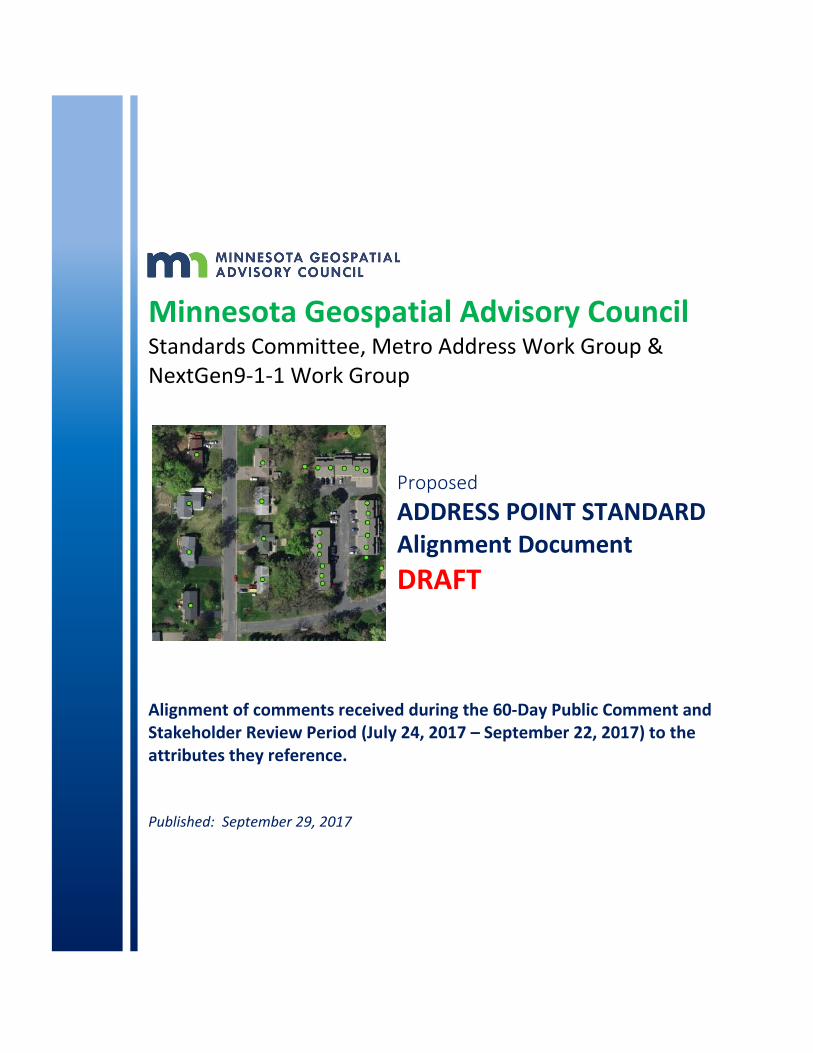
Minnesota Geospatial Advisory Council Standards Committee, Metro Address Work Group & NextGen9-1-1 Work Group
Proposed
ADDRESS POINT STANDARD Alignment Document
DRAFT
Alignment of comments received during the 60-Day Public Comment and Stakeholder Review Period (July 24, 2017 – September 22, 2017) to the attributes they reference. Published: September 29, 2017
2
Minnesota Geospatial Advisory Council Standards Committee + Metro Address Work Group
Address Point Standard - Alignment Document
Table of Contents Introduction .................................................................................................................................... 3 Purpose of this document ............................................................................................................... 3 How to use this document .............................................................................................................. 3 Part 1 – Identification Elements ..................................................................................................... 4 Part 2 – Address Elements .............................................................................................................. 5 Part 3 – Area Elements ................................................................................................................. 10 Part 4 – GeoLocation Elements ..................................................................................................... 12 Part 5 – Functional Elements ........................................................................................................ 13 Part 6 – 911 Elements ................................................................................................................... 16 Part 7 – Management Elements ................................................................................................... 17 Part Z – Other Recommended Attributes ..................................................................................... 19 Appendix A: Additional comments not specific to an attribute ................................................... 20
Questions, comments, or concerns about this document can be directed to:
Geoffrey Maas, GISP Chair, Standards Committee, Geospatial Advisory Council MetroGIS Coordinator, Metropolitan Council [email protected] 651.602.1638 Andra Bontrager, GISP Vice Chair, Standards Committee, Geospatial Advisory Council GIS Specialist, Minnesota Center for Environmental Advocacy [email protected] 651.223.5969
3
Introduction The Standards Committee of the Geospatial Advisory Council held a 60-day review period* on a proposed statewide Address Point Standard. This document contains the input, comments and suggestions provided by the geospatial community in Minnesota during this review period (July 24, 2017 through September 22, 2017). This document places the comments and suggestions received in context with the individual attributes of the proposed Address Point Standard. *On June 21, 2017, the Standards Committee decided to change its formal review period from ‘90 days’ to be defined as ‘a minimum of 60 days’. A sixty-day period was determined to be ample for stakeholders to review and provide comment on proposed standards.
Purpose of this document This document is intended to:
• Capture and list all the comments received during the public review period;
• Align these comments with the specific attributes they reference;
• Facilitate ease of interpretation of the comments in context to the proposed standard;
• Assist the Standards Committee in their decision making to advance and approve the standard;
How to use this document Each proposed attribute is listed as it was presented to the public during the review period. Many attributes listed also have an example showing how the attributes would appear in either in context or in the database itself. Any attribute for which no comments were received are ‘ghosted out’ in gray type. Attributes which received comments are shown in black with the comments received from contributors are posted beneath the attribute they reference in blue italics. The attributes are listed as grouped by their Element categories. Any additional comments received about the proposed Address Point Standard that did not align with a specific attribute are included in Appendix A of this document.
4
Part 1 – Identification Elements
Element 1.1 - Address Unique Identifier (UNIQUE_ID) FGDC equivalent: 2.3.1.1 Address ID: The unique identifier assigned to an address. Each address record must have a unique ID. This will distinguish it from any other record in the local, state or national database. It will also allow other datasets to be related to the address database (e.g. landmark names, contact phone number, existence of lifesaving equipment/defibrillator, existence of hazardous waste, etc.). >> No comments received on this attribute
Element 1.2 - Local Address Unique Identifier (ADD_ID_LOC) Each address authority may have an internal Unique_ID and formatting convention which can be included within this field. See below for further explanation. Address Unique Identifier (National) vs. Local Address Unique Identifier Each unique official address authority will likely maintain a unique identifier for each address point record. The formatting and structure of that unique identifier is completely at the discretion of the local address authority as long as the ID can be converted to a 50-character text field in this standard and maintain its uniqueness. Because it is desirable to aggregate address point data at a state or possibly even national level, it is necessary to have a nationally unique address ID in this standard. If the local address authority or partnering county does not already have a procedure to create a nationally unique ID, this may be accomplished by appending the GNIS unique ID for the city or township (in the 8-character text with leading zeros Census format) and a dash to the beginning of the local unique ID. It must be stressed that the GNIS code is meaningless once placed in the unique ID. >> No comments received on this attribute
5
Part 2 – Address Elements
Element 2.1 - Address Number Prefix (ANUMBERPRE) FGDC Element 2.2.1.1: The portion of the complete address number which precedes the address number itself. Example: 61-68 Springfield Lane Note: for an address range separated by a dash, the first number and dash will go in the prefix. This is consistent with the NENA address standard, but differs from the FGDC standard. >> No comments received on this attribute
Element 2.2 - Address Number (ANUMBER) FGDC Element 2.2.1.2: The numeric identifier for a land parcel, house, building or other location along a thoroughfare or within a community. Example: 12345 Comments: >> We have concerns that the field length for the ANUMBER field is too small. We believe a Long Integer field type would be sufficient providing 10 digits. We believe keeping the field at 6 digits may cause issues by being too small.
Element 2.3 - Address Number Suffix (ANUMBERSUF) FGDC Element 2.2.1.3: The portion of the complete address number which follows the address number itself. Example: 123 1/2 Main Street, 456 B Wilson Street >> No comments received on this attribute
Element 2.4 - Street Name Pre-Modifier (ST_PRE_MOD) FGDC Element 2.2.2.1: A word or phrase that 1. precedes and modifies the Street Name, but is separated from it by a Street Name Pre-Type or a Street Name Pre Directional or both, or; 2. Is placed outside the Street Name so that the Street Name can be used in creating a sorted list of street names. Example: Old North First Street, Alternate North Avenue B Comments: >> The fields ST_PRE_MOD and ST_POS_MOD should have the same width. As presented ST_PRE_MOD has a Width of 15 and ST_POS_MOD is 12
6
Element 2.5 - Street Name Pre-Directional (ST_PRE_DIR) FGDC Element 2.2.2.2: A word preceding the Street Name that indicates the direction or position of the thoroughfare relative to an arbitrary starting point or line, or the sector where it is located. Example: North Main Street Comments: >> Why is the Pre-Directional spelled out in this standard? These are abbreviated in the NENA standard. >> It might be useful to provide some guidance on when a directional as a part of a street name is (or isn’t) converted to be a “Pre-Directional”. For example, is any directional, regardless of how it is used the full street name, automatically converted to a “pre-directional” (i.e., Does “North Shore Dr” become Pre-Directional of “North” and Street Name of “Shore” and Post Type of “Drive”?). >> The USPS provides a little bit of guidance on how they handle situations like this: https://pe.usps.com/text/pub28/28c2_014.htm
Element 2.6 - Street Name Pre-Type (ST_PRE_TYP) FGDC Element 2.2.2.3: A word or phrase that precedes the Street Name and identifies a type of thoroughfare in a complete street name. Example: Polk County Road 14, State Highway 52, Avenue of the Stars, Boulevard of the Allies Comments:
>> Should the field ST_PRE_TYP have the same domain as the field ST_POS_TYP? >> Use core Minnesota domain derived from USPS Publication 28, Appendix F
Element 2.7 - Street Name Pre-Separator (ST_PRE_SEP) This standard uses a separator element consistent with the NENA address standard. (This is only partly consistent with the FGDC separator element which attempts to include three different types of separators in one element.) If a Complete Street Name includes a prepositional phrase between a Street Name Pre-Type and a Street Name, the prepositional phrase is treated as a separator. Example: Avenue of the Stars, Rue des Etoiles >> No comments received on this attribute

7
Element 2.8 - Street Name (ST_NAME) FGDC Element 2.2.2.5: The portion of the complete street name that identifies the particular thoroughfare. NOTE: Like the national standard, this standard requires mixed case for this element. Example: Central Street Southwest For numbered streets (e.g. Third Street, 3rd Street), use the name/spelling as defined by each official local address authority. Comments: >> “NOTE:” refers to the “National” standard that requires mixed case for the street name. Is the “National” standard mentioned the NENA standard? We also have concerns about the mixed case. We believe the Minnesota Next Generation 911 GIS Data Standards has all upper case. We believe these standards should match. We prefer all upper case.
Element 2.9 - Street Name Post-Type (ST_POS_TYP) FGDC Element 2.2.2.6: A word or phrase that follows the street name and identifies a type of thoroughfare. Example: 1234 Central Street Southwest NOTE: Like the national standard, this standard does not allow abbreviations for this element. Comments: >> Why is the Post-Type spelled out in this standard? These are abbreviated in the NENA standard. >> Should the field ST_PRE_TYP have the same domain as the field ST_POS_TYP?
>> We have the same question about whether the “National” standard being referenced is the NENA standard? We believe the Minnesota Next Generation 911 GIS Data Standards is using the Post Office PUB 28 abbreviations. We believe these standards should match. We prefer the PUB 28 abbreviations over spelling them out completely.
Element 2.10 - Street Name Post-Directional (ST_POS_DIR) FGDC Element 2.2.2.7: A word following the Street Name that indicates the direction or position of the thoroughfare relative to an arbitrary starting point or line, or the sector where it is located. Example 1234 Cherry Street North NOTE: Like the national standard, this standard does not allow abbreviations for this element. Comments: >> Why is the Post-Directional spelled out in this standard? These are abbreviated in the NENA standard. We have the same question about whether the “National” standard being referenced is the NENA standard? We believe the Minnesota Next Generation 911 GIS Data Standards is using the Post Office PUB 28 abbreviations. We believe these standards should match. We prefer the PUB 28 abbreviations over spelling them out completely.
8
Element 2.11 - Street Name Post Modifier (ST_POS_MOD) FGDC Element 2.2.2.8: A word or phrase that follows and modifies the Street Name, but is separated from it by a Street Name Post Type or a Street Name Post Directional or both. Example: 1230 Central Avenue Extended Comments: >> The fields ST_PRE_MOD and ST_POS_MOD should have the same width. As presented ST_PRE_MOD is Width: 15 and ST_POS_MOD is 12
Element 2.12 & 2.14 – Sub address Type1, 2 (SUB_TYPE1 & SUB_TYPE2) FGDC Element 2.2.4.1: The type of sub address to which the associated Subaddress Identifier applies. Example: Apartment 17C, Building 6, Tower B, Floor 2, Suite 1040 Comments: >> Use NG911/CLDXF subtype fields for domain (below)
CODE VALUE OR DEFINITION
BUILDING BUILDING
FLOOR FLOOR
UNIT UNIT
ROOM ROOM
SEAT SEAT
Element 2.13 & 2.15 - Subaddress Identifier1, 2 (SUB_ID1 & SUB_ID2) FGDC Element 2.2.4.2: The letters, numbers, words or combination thereof used to distinguish different subaddresses of the same type when several occur within the same feature. Example: Apartment 17C, Building 6, Tower B, Floor 2, Suite 1040 Within the national standard, the two sub address elements are formatted as repeating pairs because some addresses have multiple sub address types. This is easy to do in an XML schema, but in a database, requires a related table. Because many GIS practitioners have implementations that use flat files without related tables (e.g. shape files), this standard uses two sets of sub address elements. Any additional sub address information should be put into the Location Description (LOC_DESC) field. Comments: >> These do not fully cover the purpose of the fields Building, Floor, Unit, Room, and Seat. Part of their purpose is to be able to easily and quickly drill down to a specific spot in a building in an emergency situation and these sub address fields do not allow for that. I would caution against having these sub address fields replace the specific location fields.
9
>> I do not want to take time to fill out any fields, only to have them be discarded almost immediately. Some examples:
• BUILDING, FLOOR, UNIT, ROOM, SEAT
• PLACE_TYPE
• ELEVATION
• EXCEPTION
Element 2.16 - ZIP Code (ZIP) FGDC Element 2.2.6.4: A system of 5-digit codes that identifies the individual Post Office or metropolitan area delivery station associated with an address. Comments: >> Recommend this attribute be Conditional in short term due to status of Greater MN data; should be eventually made Mandatory long term
Element 2.17 - ZIP Plus 4 (ZIP4) FGDC Element 2.2.6.5: A 4-digit extension of the5-digit ZIP Code (preceded by a hyphen) that, in conjunction with the ZIP code, identifies a specific range of the USPS delivery addresses. >> No comments received on this attribute
10
Part 3 – Area Elements
Element 3.1 - Municipal Jurisdiction Name (MUNI_NAME) FGDC Element: Represented by 2.2.6.1 Place Name and 2.3.8.4 Place Name Type. The name of the incorporated municipality (city, township, or other local government, excluding counties) in which the address is physically located. In many places, this will be different than the city name used by the U.S. Postal Service Example: Bloomington, Lake View Township, Rushford Note: By default, the spelling of the municipality name will comply with GNIS standard name. A city may change the standard name to an abbreviated format (Saint vs St.) if needed although this standard encourages the use of the GNIS standard where possible. Comments: Should we use MUNI_NAME or CTU_NAME? ALL CAPS or Mixed Case? Use DEGRAFF without a space (not DE GRAFF)
Element 3.2 - Municipal Jurisdiction Code (MUNI_CODE) FGDC Element 2.3.8.5 (GNISFeature ID): The official Federal Geographic Names Information Systems unique identifier code for the city, township or unorganized territory in which the address is physically located. There are two Federal formats: 1. The U.S. Census text format with leading zeros is required in this standard 2. The national standard specifies the integer USGS integer format. The State of MN calls this the “CTU” identifier which provides for either formats. Comments: Use GNIS_ID or CTU_ID_CEN? CTU_ID_CEN matches the GNIS_FEATURE_ID_TEXT field of the Minnesota CTU Database
11
Element 3.3 - Postal Community Name (POSTCOMM) FGDC Element represented by 2.2.6.1 Place Name and 2.3.8.4 Place Name Type: The default city name defined by the U.S. Postal Service for the address. The USPS defines a default city name for each ZIP Code. In many places, this will be different than the name of the city or township in which the address is physically located. For example, addresses within the cities of Hermantown and Proctor use the ZIP Code of 55810, but the USPS default city name for this ZIP Code is Duluth. Thus, the Postal Community Name for addresses within Hermantown and Proctor is Duluth. The default city name for a given zip code can be found using this USPS form. Comments: Use full statewide domain USPS community names; It might be worth noting that there may be more than one “acceptable” postal community name. For example, in ZipCode 55124, the USPS “preferred” name is “SAINT PAUL”, but they also list “APPLE VALLEY” as acceptable. Because many people are confused when they see “55124” and “SAINT PAUL”, Dakota County prefers to use “APPLE VALLEY” for points that fall in the 55124 ZipCode rather than UPSS’ “preferred” value of “SAINT PAUL”.
Element 3.4 - County Code (CO_CODE) FGDC Element represented by 2.3.8.6 ANSI State County Code: The combination of the two character state numeric code and the three character county code in which the address resides. Note: Both state and county codes are national and state approved standards. Comments: Use full statewide domain of County Codes Use COUNTY instead of CO_CODE?
Element 3.5 - County Name (CO_NAME) The county in which the address resides. Domain: County Name Comments: Use full statewide domain of County Names
Element 3.6 - State Code (STATE_CODE) FGDC Element 2.2.6.3: The names of the US states and state equivalents. The names may be spelled out in full or represented by their two-letter USPS or ANSI abbreviation. Note: This standard has specified the two-character code to remove any ambiguity. This will always be “MN” for Minnesota. Comments: Should we use STATE_CODE or STATE? Use NG911 domain, includes Ontario and Manitoba;
12
Part 4 - GeoLocation Elements
Element 4.1 - Longitude (LONGITUDE) FGDC Element 2.3.2.3: The longitude of the address location, in decimal degrees, WGS84 datum. Example: -84.29049105 >> No comments received on this attribute
Element 4.2 - Latitude (LATITUDE) FGDC Element 2.3.2.4 Address Latitude: The latitude of the address location, in decimal degrees, WGS84 datum. Example: 33.77603207 >> No comments received on this attribute
Element 4.3 - US National Grid Code (USNG_CODE) The code for the US National Grid cell within which the address point exists. Example: 18SUJ2348306479 (Locates a point with a precision of 1 meter) Note: This element may be populated by a data aggregating organization (e.g. a county). >> No comments received on this attribute
13
Part 5 – Functional Elements
Element 5.1 - Location Description (LOC_DESC) FGDC Element 2.3.7.8: A text description providing more detail on how to identify or find the addressed feature. Example: White house at intersection, 400 yards west of water tank >> No comments received on this attribute
Element 5.2 - Complete Landmark Name (LANDMARK) FGDC Element 2.2.5.2: One or more landmark names which identify a relatively permanent feature of the landscape that has recognizable identity within a particular cultural context. Note: Any individual address could represent multiple landmarks, all of which may be included in this element. >> An additional secondary landmark name would be beneficial if a location has more than one landmark name. We would like to propose a second landmark name field.
Element 5.3 - Residence (RESIDENCE) Indicates if address has a residence or living quarters. This also includes multi-use addresses that include a residence when no other address for that residence exists in the database. This data element is not intended to indicate whether the residence is currently occupied. Thus, apartment units would be included whether they are occupied or vacant. >> I am pleased to see that “Residence (Y/N/U)” is currently included in the proposed standards as an optional field. Please consider expanding the categories to include possible commercial and mixed-use responses. Because the residence field is so critical to a full and complete census count, please consider making it a mandatory or conditional element. >> I support the inclusion of an element that allows one to distinguish the number of units in a multi-unit building. It appears that this can be accomplished with the “SUB_ID” fields. Please consider how the “Residence” field and “Subunit” fields might be jointly reported to identify whether units within a multi-unit building are residential or commercial. >> Use the NG911 Domain which includes Single and Multiple >> Possible domain values: Yes
Single (Single-Family) Multiple (Multi-Family) No Unknown Commercial Mixed Use
14
Element 5.4 - Mailable Address (MAILABLE) FGDC Element 2.3.7.9: Identifies whether an address should have USPS mail sent to it. Example: An address for a cell tower or park with no mailbox would not be a mailable address. >> No comments received on this attribute
Element 5.5 - Parcel Unique Identifier (PIN) FGDC Element 2.3.3.1: The primary permanent identifier, as defined by the address parcel identifier source, for a parcel that includes the land or feature identified by an address. Note: It is recommended that the state code be added to the beginning of the PIN string to accommodate cross state boundary compatibility Example: 27003-1234-56-78910 <ANSICountyCode>-<CountyPIN> >> No comments received on this attribute
Element 5.6 - Placement Method (PLACEMETH) A code that indicates the method used for placing the point. The NENA address data standard includes a similar data element. Because many state geospatial practitioners require more detail with this element, this standard has created its own element with a crosswalk to the NENA values. Comments: >> Change field to Long Integer It would be more straightforward to have two fields and domains that replace the current placement method field. Placement Location:
▪ Driveway Access ▪ Building ▪ Building Doorstop ▪ Building Unit Location ▪ Within Parcel ▪ Other ▪ Etc.
Placement Method:
▪ Centroid Calculation ▪ Aerial Imagery ▪ GPS ▪ Plat ▪ Other ▪ Etc.
15
Placement Method should include (if not changed to the above suggestion):
• Aligned to building based on aerial photo
• GPS at driveway access
• GPS at structure
Element 5.7 - Centerline Geocodable (CEN_GEO) Used to identify official addresses that have been validated by the addressing authority and confirmed to not be included in the corresponding road centerline data. Such addresses would have a “No” value in this element. This is very useful to know for 9-1-1 dispatching purposes. Examples of such addresses include official addresses on islands without named roads and historical “grandfathered” addresses. >> No comments received on this attribute
16
Part 6 – 911 Elements
Element 6.1 - GIS Authority 911 (GISAUTH911) The entity responsible for submitting Geographic Information System (GIS) data to the State of Minnesota to be used for NG9-1-1 service for a specified area. This is typically a county GIS department or Public Safety Answering Point (PSAP). In its County 9-1-1 Plan, which is submitted to the Minnesota Department of Public Safety, a county must specify the 9-1-1 GIS Authority/Authorities for each of the required NG9-1-1 datasets that encompass the county’s geographic area. Comments: >> Change field name to GIS911POC >> Use NG911 domain (i.e. County Names & Red Lake Nation)
Element 6.2 - Emergency Service Number (ESN) A 3 to 5 digit number that identifies a single ESZ. ESNs are included in the MSAG for a given PSAP and represent unique combinations of individual fire, law, emergency medical response and other emergency agencies. >> No comments received on this attribute
Element 6.3 - MSAG Community Name (MSAG_C) The Community name associated with an address as given in the Master Street Address Guide (MSAG) used for 9-1-1 purposes. This may or may not be the same as the Municipal Jurisdiction Name or the Postal Community Name. Comments: >> Use NG911 domain for MSAG Community
17
Part 7 – Management Elements
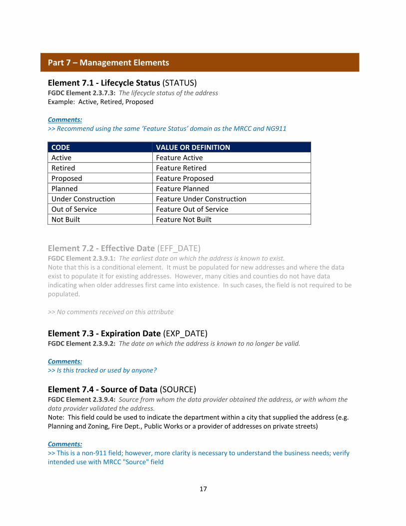
Element 7.1 - Lifecycle Status (STATUS) FGDC Element 2.3.7.3: The lifecycle status of the address Example: Active, Retired, Proposed Comments: >> Recommend using the same ‘Feature Status’ domain as the MRCC and NG911
CODE VALUE OR DEFINITION
Active Feature Active
Retired Feature Retired
Proposed Feature Proposed
Planned Feature Planned
Under Construction Feature Under Construction
Out of Service Feature Out of Service
Not Built Feature Not Built
Element 7.2 - Effective Date (EFF_DATE) FGDC Element 2.3.9.1: The earliest date on which the address is known to exist. Note that this is a conditional element. It must be populated for new addresses and where the data exist to populate it for existing addresses. However, many cities and counties do not have data indicating when older addresses first came into existence. In such cases, the field is not required to be populated. >> No comments received on this attribute
Element 7.3 - Expiration Date (EXP_DATE) FGDC Element 2.3.9.2: The date on which the address is known to no longer be valid. Comments: >> Is this tracked or used by anyone?
Element 7.4 - Source of Data (SOURCE) FGDC Element 2.3.9.4: Source from whom the data provider obtained the address, or with whom the data provider validated the address. Note: This field could be used to indicate the department within a city that supplied the address (e.g. Planning and Zoning, Fire Dept., Public Works or a provider of addresses on private streets) Comments: >> This is a non-911 field; however, more clarity is necessary to understand the business needs; verify intended use with MRCC "Source" field

18
Element 7.5 - Address Authority (AAUTHORITY) FGDC Element 2.3.1.2: The name of the authority (e.g., municipality name, county name) that created or has jurisdiction over the creation, alteration, or retirement of an address. Note: Entities other than cities and counties might be possible here (e.g. U of M, 3M (on their campus), Mille Lacs Band of Ojibwe, US Forest Service). Comments: >> This is a non-911 field; more clarity is necessary to understand the business need for this attribute >> Recommend changing this to Optional
Element 7.6 - Editing Organization (EDIT_ORG) This is intended to indicate the organization that made the last change to the data record. This field may not be necessary if the official address authority is clearly defined and is the only organization that is allowed to edit a record. However, based on the various ways envisioned for regional and state aggregated address point datasets to be created in Minnesota, this element is expected to be of use and has been requested by stakeholders. Comments: >> This is a non-911 field; more clarity is necessary to understand the business need for this attribute
Element 7.7 - Edited Date (EDITED_DT) The date that a record was added or changed in the address points dataset. This should preferably be filled by the editing application whenever there is an edit. When first creating an address points dataset, all record may be populated with the date of database creation. Note, this element is not part of the National Standard. Comments: >> Is this tracked or used by anyone?
Element 7.8 - Comments (COMMENTS) A field for free form comments as deemed useful by the address authority. >> No comments received on this attribute
19
Z. Other Recommended Attributes
Element Z.1 – Concatenated Address (ACONCAT) Text, Width = (Unknown), Conditional or Optional Recommend adding a concatenated address field to assist with geocoding.
Element Z.2 – Secondary Landmark (SCNDLMRK) Text, Width = (Unknown), Optional Recommend adding Secondary Landmark field
Element Z.3 – Legacy Street Name (LEGACYST) Text, Width = (Unknown), Conditional or Optional Recommend adding a legacy street as optional fields for those who want to maintain their street names differently than the standard recommends. They may also be helpful during the transition period to map data based MSAGs.
Element Z.4 - Exception (EXCEPTION) Text, Width = 10, Mandatory Recommend adding EXCEPTION field due to strong business need for use in Quality Assurance Recommended domain values: Yes, No
Element Z.5 – Place Type (PLACETYPE) Text, Width = (Unknown), Optional Request for a NG911 attribute for place type which will include the place type (Airport, Office, Hotel) See: http://tools.ietf.org/rfc/rfc4589.txt
Element Z.6 - Country (COUNTRY) Text, Width = 2, Optional Recommend adding country Code to the Proposed Standard Recommended domain values: US, CA
Element Z.7 – PSAP (PSAP) Text, Width = (Unknown), Optional Request for a NG911 attribute for PSAPs
Element Z.8 – Number of Units (NUMUNITS) Long Integer, Width = Conditional or Optional Request for an attribute that indicates number of units in multi-family buildings, apartments, etc.
20
Element Z.9 – URI (URI) Text, Width = (Unknown), Conditional or Optional Request for an attribute that enables storage of a URI
Element Z.10 – Address Type (ADTYPE) Add an optional field for address type. This field may include domain values such as:
• Infrastructure for Utility addresses
• Primary for a building address without a sub address designation
• Secondary for sub addresses with unit designations
• Provisional for addresses added before they are confirmed as official
• Unofficial for addresses that are not approved by the addressing authority, but are known to be in use
• ParcelSitus for parcels where the Parcel situs address is also duplicated by a doorway address on that parcel; It allows for managing parcel and site structure addresses in the same data set
Element Z.11 – CAD Address (CADADDR) Add a second optional attribute for CAD Address. This would designate which addresses would be loaded into a Computer Aided Dispatch System (CAD). There are no CAD systems available today that can geo-verify an address to the sub-address level. It would meet a strong business need for PSAPs to be able to create an address point data set for use in their CAD where each point is unique with regard to: Address Number, Address Number Suffix, Street Name Elements, and City. Adding this field could also benefit any user of the dataset not needing address points down to the sub address level.
21
Appendix A: Comments Not Related to a Specific Attribute
Add Concatenated Field for Entire Address A concatenated field for the entire address would assist in geocoding addresses and integrating with various enterprise applications. We would like to propose the inclusion of a concatenated full address field with the new address point standard. Add Secondary Landmark Attribute An additional secondary landmark name would be beneficial if a location has more than one landmark name. We would like to propose a second landmark name field. Legacy Street Name Fields I think they should be included as optional fields for those that want to maintain their street names differently than this standard recommends. They may also be helpful during the transition period to map data based MSAGs. Field Names: Please keep the field names harmonious between the Address Point Standard as well as other standards. For example, ST_NAME should mean the same thing in the address point standard, centerlines, parcels, as well as any other state GIS standard. Is more than one address point standard being advanced? I thought the NG9-1-1 Address Standard is intended to be the “master” Statewide Address Point Standard. This is the reason why we heavily discussed the “Minnesota Added Fields” and whenever it made scene we included fields from the Metro Address Point Standard. The NG9-1-1 Address Standard is not finalized yet so is it too early use the NG9-1-1 Address Standard as a source for the statewide standard? Maybe I am missing something here, but my thoughts are that as a county I only want to deal with one standard. I think that publishing two address point standards will only result in confusion, frustration, and more work. I strongly recommend that we work together so that we can publish a single standard that will meet all the needs. Optional variables part of NG9-1-1 but not part of the proposed Address Point Standard Any optional variables that are part of NG9-1-1, but not part of MN will NOT be included, that is unless I
decide that we have a business need to keep those variables beyond the transition to the MN state
standard. For example, I don’t think I need ELEVATION in my dataset, however I want to include
PLACE_TYPE in some format even if it is not part of the MN Address Point Standard.
22
EXCEPTION attribute What do I do with the field EXCEPTION? It is a mandatory field in NG9-1-1, but not even included in the Address Point Standard. That to me tells me that it is either:
• Missing from the MN Standard,
• Not really mandatory, or
• A transitional or legacy attribute and therefore should be called LST_EXCEPT or similar? Spelling error: In your domain of values for 5.6 Placement Method– Code 5 the word “entrance” is misspelled as “entrace”.
Missing Fields and Domains from NG9-1-1 Here are some fields that I happened to notice that are missing from the Address Point Standard
Place Type I requested a NG911 attribute for place type which will include the place type (Airport, Office, Hotel) See: http://tools.ietf.org/rfc/rfc4589.txt
Country
Does it matter if we include US or CA or is supplying the “State” sufficient for Ontario and
Manitoba?
PSAP I noticed PSAP is missing. Is this not important?
Effective and Expiration Dates Does anyone use the effective or Expiration dates?
URI Should we have a URI, or is that considered an internal only attribute?
Residence Please include
• Yes (but unsure what type)
• Multiple (Multi-Family)
• Single (Single-Family)
• No
USPS Publication 28 Address Standard
I heard a few people comment that they are going to miss the Pub 28 standards. I think it is
easier to type in the abbreviated street post type (‘ST’, ‘AVE’) as opposed to the fully spelled out
street name post type (‘STREET’, ‘AVENUE’)
23
• On maps, I would rather use the abbreviated label as they are shorter;
• Will there be any issues with dispatch if call taking software cannot handle the fully spelled out street post types or if dispatchers enter in the abbreviation – which might be what they have been using their entire life? - We might have to know more about the call taking software to answer this one.
I would like these fields to be optional since many people will use them, and conditional if a
neighboring counties dispatch software cannot handle the NG9-1-1 fields.
Metadata The documentation should include a description of what the metadata specifications are. Addition of New Records: How can new records be added to the standard tables? (i.e. new Address Post Type for instance Entr for Entrance) Handling of Alias Street Names: How will this standard handle alias street names? (i.e. London Rd vs State Hwy 61 or W Michigan St vs. Bob Dylan Dr) Additional Attributes Desired by 9-1-1 Systems: Sub-Address Type, Address Type & CAD Address
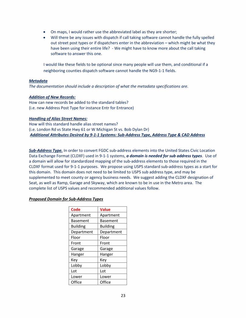
Sub-Address Type. In order to convert FGDC sub-address elements into the United States Civic Location Data Exchange Format (CLDXF) used in 9-1-1 systems, a domain is needed for sub address types. Use of a domain will allow for standardized mapping of the sub-address elements to those required in the CLDXF format used for 9-1-1 purposes. We propose using USPS standard sub-address types as a start for this domain. This domain does not need to be limited to USPS sub address type, and may be supplemented to meet county or agency business needs. We suggest adding the CLDXF designation of Seat, as well as Ramp, Garage and Skyway, which are known to be in use in the Metro area. The complete list of USPS values and recommended additional values follow. Proposed Domain for Sub-Address Types
Code Value
Apartment Apartment
Basement Basement
Building Building
Department Department
Floor Floor
Front Front
Garage Garage
Hanger Hanger
Key Key
Lobby Lobby
Lot Lot
Lower Lower
Office Office
24
Penthouse Penthouse
Pier Pier
Ramp Ramp
Rear Rear
Room Room
Seat Seat
Skyway Skyway
Side Side
Slip Slip
Space Space
Stop Stop
Suite Suite
Trailer Trailer
Unit Unit
Upper Upper
Two additional recommendations are not required for the 9-1-1 system, but are offered as suggestions for address point data management: Address Type Add an optional field for address type. This field may include domain values such as:
• Infrastructure for Utility addresses
• Primary for a building address without a sub address designation
• Secondary for sub addresses with unit designations
• Provisional for addresses added before they are confirmed as official
• Unofficial for addresses that are not approved by the addressing authority, but are known to be in use
• ParcelSitus for parcels where the Parcel situs address is also duplicated by a doorway address on that parcel; It allows for managing parcel and site structure addresses in the same data set
CAD Address Add a second optional attribute for CAD Address. This would designate which addresses would be loaded into a Computer Aided Dispatch System (CAD). There are no CAD systems available today that can geo-verify an address to the sub-address level. It would meet a strong business need for PSAPs to be able to create an address point data set for use in their CAD where each point is unique with regard to: Address Number, Address Number Suffix, Street Name Elements, and City. Adding this field could also benefit any user of the dataset not needing address points down to the sub address level.