Embed Size (px)
Citation preview
MYDHOI,OGIC I N izORMA'I'ION FOR 4 ",lt 3 9 !.AN D4JSEi P !,I?,~\L,BC;~G, ILL'! i,[.oAR LCS
C911ts'Y u RI.ASLCA
:: ....... <,A<> ?..O:~.-.
p ,/,:;;,, & *,*, ??&, Qv :+ * .4.. .,,. +w: 3 . -3 .;x., , --
"'i ; :>) ,+ uyJg.:
, . -F," *++, 4, 4 ,$ --+A&. c.h:3:.L? J
--:- ;'-.--, - .
U N I T E D STA'TES
DEPARTMENT OF THE INTERIOR
GEOLOGICAL SURVEY
Prepared i n c o o p e r a t i o n
with the F a i r b a n k s iiorth S t a r Oorough,
U.S. Environmental Protection Agency,
and U.S. Army Corps
o f E n g i tleers

UPlITt U STATES ~ [ . ~ > , ~ { ~ i ~ i 9 ~ ~ : ~ ; ~ 01- -1 1 ~ i ~ : ( ~ . [ ~ I[)!;
GF:O!.Ll: i C F j i SI.JR\/l.'i
HY[ )ROLOI ; IC . INf"G%*l,A,r- I G , i FOR L.AK3-USE PLAN?/ ING
FAIRP,A?I1KS V I L L r l l T Y , A L A S K A
Prepared i n cooj:i:!ra t i o n w i ti1 Fai rbanks N o r t h Star Gorouc~ t~ ,
U . S . E n v i ror-lrr:critsl Protectinrl Aqcncy, U . S . Ariily Car-ps o f kr~gi rli:?t7s

U I I I [i:D S T A I E S UEPiJ,RTi~1EFIT OF TliE I N - I E R I O R
Crlci 1 B. And)-us , Sc?cr*et.ary
GEOLOGICAL SlJKVEY
t i . W. L!znard, Direc tor
.- . .-- - - . -
For d d d i t i ona l i n i ~ l - ~ z d t i f i n 1 : ) - i Lc t o :
U S . Geol o g i ca l Survey !~l~il;;ir Fiesour-ci?s U i v i s ign 218 E S t r e e t , Sky1 ilio 3 : ~ i l d i n g Anchorage, A1 a s k a 99501
CONTENTS
Page
. . . . . . . . . . . . . . . . . . . . . . . . . . . . . . . . . . . . . . . Nont t !ch t ; i cz l sc:-,,,,,:.rj. . . . . . . . . . . . . . . . . . . . . . . . . . . . . . . . . . . . . . . . . . . . . . . . G l o s s a r y
I n t r o d u c t i o n . . . . . . . . . . . . . . . . . . . . . . . . . . . . . . . . . . . . . . . . . . . . . . . . S e t t i n g
P h y s i o g r a p h y and g c o l o g y . . . . . . . . . . . . . . . . . . . . . . . . . . . . . A m Perrnafr -ost . . . . . . . . . . . . . . . . . . . . . . . . . . . . . . . . . . . . . . . . . . . . .
. . . . . . . . . . . . . . . . . . . . . . . . . . . . . . . . . . . . . . . . . . P r e c i p i t a t i o n E v a p o t r a n s p i r a t i o n . . . . . . . . . . . . . . . . . . . . . . . . . . . . . . . . . . . . . Waste d i s p o s a l . . . . . . . . . . . . . . . . . . . . . . . . . . . . . . . . . . . . . . . . .
F l o o d - p l a i n h y d r o l o g y Su r face w a t e r
Tanz r~a R ive r . . . . . . . . . . . . . . . . . . . . . . . . . . . . . . . . . . . . . . . Chena R i v c r . . . . . . . . . . . . . . . . . . . . . . . . . . . . . . . . . . . . . . .
Ground w a t e r . . . . . . . . . . . . . . . . . . . . . . . . . . . . . . . . . . . . . . . . . . . E f f e c t s o f r r ~ o d i f i c a t i o r l s t o t h u h y d r o l o g i c s y s t e r ~ i
. . . . . . . . . . . . . . . . . Chena Lakes F l o o d Con tr-01 P r o j e c t . . . . . . . . . . . . . . . . . . . . . . . . . . E f f e c t s of heavy pu:slpi nz
. . . . . . . . . . . . . . . . D r a i n ~ s e p r o b l ciiis a f l f c t i ng dcvcl opi . ier~t Q u a l i t y o f w a t e r .......................................
S u r f a c e w a t e r . . . . . . . . . . . . . . . . . . . . . . . . . . . . . . . . . . . . . Ground water. . . . . . . . . . . . . . . . . . . . . . . . . . . . . . . . . . . . . . .
Env i ronn ien ta l c o n s i d e r a t i o n s o f s e p t i c sys tems . . . . . . . . . Up1 ands h y d r o l o g y
. . . . . . . . . . . . . . . . . . . . . . . . . . . . . . . . . . . . . . . . . . . . . . . . Streams a pr . . . . . . . . . . . . . . . . . . . . . . . . . . . . . . . . . . . . . . . . . . . Grourld VI- ' t
. . . . . . . . . . . . . . . . . . . . . . . . The g round- water sys tci i? ... .. . . . . . . . . . . . . . . . . . E f f e c t s o f g r o u n d - w a t e r punlping
. . . . . . . . . . . . . . . . . . . . . . . . . . . . . . . . . . . Ground-water q u a l i t y E n v i r o r l r i ~ c n t a l c o n s i d e r a t i o n s o f s e p t i c sys te1 .1~ . . . . . . . . .
R e f e r c n c c s c i t e d . . . . . . . . . . . . . . . . . . . . . . . . . . . . . . . . . . . . . . . . . . . .
Cover . - - l lo i i~e ddr;iayed by a u f e i s f r o m Chena S lough n c d r P lacF: Road . (See page 24.) Photos hy Thoi:!~s Kecver .
1 . L o c a t i o n s o- f s t r -es in -gag ing s t a t i o n s a n d viea ti~r-!r s t a t i o n s of t h e Fairbctr'lks a res and pl-lysiogr-tipiiic ant ! ge:igrap:?ic
. . . . . . . . . . . . . . . . . . . . . . . . f e a t u r e s mentioned i n t h e t e x t
2 . Sci- icmatic s e c t i o r ~ showing pt1ysiogr; lptr ic and g e o l o g i c terrris . . . . . . . . . . . . . . . . . . . . . . . . . . used t o d e s c r i b e t h e u p l a n d s
3 . N e t d e f i c i e n c y o f p r - c c i p i t a t i o n a t F a i r b a n k s I n t e r r ~ a t i o n a l . . . . . . . . . . . . . . . . . . . . . . . . . . . . . . . . . . . . . . A i r p o r . t , 1972-7G
iii
Page
4. Corlrparison o f discharge of the Tariana River a t Faii-?:c?nks N i t h i.;.;,:pei.dture a l ld i:,~*ct:ipitation a t Eig Del t a , P,iltjl.lst
and S ( ? p t ~ ~ i i S ~ r , 1974. B i q i!el t a i s t7ear ti-ic ~:la:ii~tains about 7 7 ~ n i l e s soii".i~r.;ist o f F 2 i l-hanks.. . . . . . . . . . . . . . . . . 15
5. Flond freqrlcncy cur.ves f o r 'Tal!,yna River d t i4enann and CI-~cna River a t Fa i i + i : i ~ l ~ k s . . . . . . . . . . . . . . . . . . . . . . . . . . . . . . . 17
6 . Water-tab1 c c o n f igura t iun when the ,+qui f e r i s r~char-ged by the "Tan;na River a n d d l -a i r i cd by the Clicna River (da ta froril Ju ly 20 , 1 9 7 5 ) . \ l a t e r - t ab le dcpl-ess~inns a t A and
. . . . . . . . . R a r e cnuscd by c o r ~ s i r ~ ~ c t i o n - - s i t e dcv!atering.. 19
7 . Goohydrologic sec t ion along 1 ine x - x 1 in f i g u r e 6 . Water tab1 c s lopes f I-OIII the T a n a n a River t o t h e Ct~:?tla River. . ? 0
8. Hater-tab1 e cor?ficj~:rat i o n s when both the Chena and Tarlarla Rivc.rs a r e reciiat.y i rig the a q u i f e r ( d a t a f r c i n i.lay 20, 1978). . . . . . . . . . . . . . . . . . . . . . . . . . . . . . . . . . . . . . . . . . . . . . . . . . 2 1
9 . Fairbanks v i c i n i t y , Alaska, s h o w i n g pr inc ipal f e a t u r ~ s of the Ckcrla I-akcs l'lood Control ?I-oject: the dam, levt.e, and i n t e r i o r drainayc d i t c h ~ s ......................... 2 2
10. G ~ r ~ ~ r ' a l i,:(:d / i j ' i l j ' ~ l ugic :;?~;tinn s h c w i n g seasnr:al c t ~ d r ~ c j e s in "Lie slope o f t i - l t? \:,.i l,:r- -;:ah1 P be"iwi?en the Tar-~;~na River and CI~:?rla S l ~ ~ i g h . i )~ j~- i r -g tilt? S:fli:r"izr, Cilzna Slough i s an c f - f c c t i v e dr -a in 2nd 1c:ri:t-s tile water t a b l e . During the wirltcr, i t becoiiies o i : r l u d ~ d by i c e , a n d i s an i n e f f e c t i v e d ra in . The kjater t a b l e tile11 r i s e s . . . . . . . . . . . . . . . . . . . . . 25
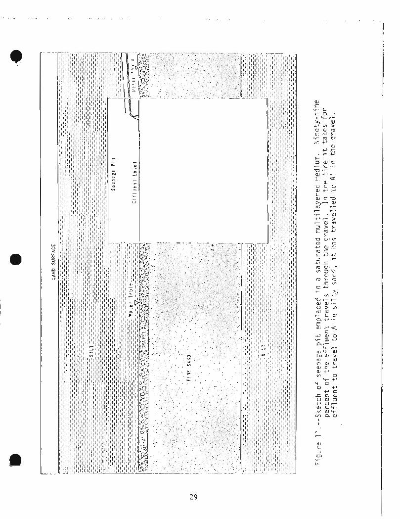
11 . S k c t z h of seep2ge p i t :.:ilipl ai:i:jtl i n a ~ ~ t i i t - a t . ~ d l n u l t i ? zyc-.t-i.d I . Nincty-nine p?r'ccnt o,f ti-;@ efflurint "L-avcls t h r o u g h the gravel . In the time i t takes f o r e f f l u e n t t o t ravel t o A in t h e s i l t y sund, i t has t rav2led t o A1
. . . . . . . . . . . . . . . . . . . . . . . . . . . . . . . . . . . . . . . . . . in t h e grdvcl 2 9
1 2 . I.oc:a t i a t i s o f 1 0 2 : - f l c ; ~ s i:ations on st~*t:.;i,ls in the F a i r!j;riks 3 t ' ~ ' a \ v i i i ~ h ~ ; G V C S h ( 3 ~ 1 1 ~ i ~ i l d i e d *LO d ? t ~ t - i ~ i i lie 'il-I? b d s e f l ow co~-~tr ibui- .ed by l e zksge f r o m t he beifrock aquifer.. . . . . . . 3 5
be nearly dry ......................................... 3 7
- ,> ,

Page
Loca t ions o f w ~ l l s on r i d g e t ops a n d upper s l o p e s i n w h i c h h e a d losscs have bcen recorded. Amount o f l o s s ~ s and pe r i ods o f record f o r the w e l l s a r e l i s t e d i n t h ? t a b l e
. . . . . . . . . . . . . . . . . . . . . . . . . . . . . . . . . . . . . . . . . . . . . . . . . . . b p l o ~ ! 38
t1yd.r-oyraph o f we1 1 50 ,176 s i tuzteci on r i d g e t op o v e r l o o k i n g Far-rrier's Loop Road. (We1 1 loca t io r i o f f i g u r e 1 4 ) . . . . . . 39
G ~ n e r a l i zed hydroy?ol o g i c coqdi t i o n s on the lower s l o p e s . A s u b s t d n t i a l thick:<.:\ o f los.,-peri,1cc:ti1 i t y s i l t o v p r - l i e s w a t e r - b e a t - i n g b ._ i t - c 1 . Wells car; s t i l l y i c l d adecluatc wa t c r f o r dot-ist tic pu rposes i f the p o t e n t i o - rnetr-ic surfdcc f a l l s s evc ra l t e n s o f f e e t . . . . . . . . . . . . . . . 40

1 INCH-POUND U N I T S AIGD S I UrJI TS E Q U I V A I - t l I T S
I S I , In te rna t iona l Systeln of I l n i t s , i s a i ~ i o d ~ r n i z e d r;-ietric systein o-f rncasureri~cnt. A1 1 val ues have bcien rou~lded t o Tour s i cjni F i c a n t digi ts . Note t ha t the s t y l e " i i i c te r2 " rather t h a n "sq!lai7e i-wtc_rl' has bccn used f o r convenience i n f i n d i n g u n i t s i n th is t a b l ~ . bWre t h e
1 un i t s a r e spel led o u t in t i l e t e x t , Survey s t y l e i s t o use "square r~leter".
I M u 1 t i ply Inch-pound u n i t -. - - . - - - . . -. -- - . - - _by_ t o . - -- obtain . . . - - S I -- uni t - - .- equivalent* - . --
inch ( i n . ) foo t ( f t ) n - ~ i l e ( m i )
Area -
V o l vine -.- --- -
0.09290 iiietcr2 (m2 ) 0,4047 hectare (ha)
I yallon ( g a l ) 3 . i 8 5 1 i t e r ( I - )
V o 1 U!~l?
,er u n i t tirrle ( f l o w ) r -- .. - - - --
Vo 1 . - .. .
u n j t .. tilile -. . . . ( f l ow) . . . - I
f o o t 3 pcr sc?coc-~d ( f t 3 / s ) 0.37332 ; i ~ : t e r ~ j r ~ r c-cond (m3/s) I gallon per 1;iinutc (ga l / i~ l in ) 0.063i39 1 i i a r p e r sccond ( L / s )
I l i ydro l . og icg rope r t i c s -. .- - -- - I
Transmi s s i v i t y
IQdrol oy ic p i - q e r t i es - - -- . . - - -- -- .-
T r d n s m i s s i v i ty
I f o o t 2 per day ( f t 2 / d ) 0.09290 r;-ieter2 per day (m2/d)
U n i t r u n o f f o r recharge U n i t runoff o r recharge
gallon pcr year p e r a c r e 1.532 1 i t e r ler y r a r per hectare [ ( g a l /y r ) /acre] [ ( I - / Y ~ \ / ~ I ~ I
Hydraulic conductivity Hydraul i c c o n d u c t i v i t y
f o o t pcr day ( f t / d ) . 0.3045 ineter per day ( ~ n / d )
foot per 111ilc (ft/lni ) 0.1&94 meter p?,- k i 1 ornetcr (m/km)
v i

HYDROLOGIC I N F O R ~ ~ I A T I O ~ I FOR 1.APtD-USE PLANNING
FAIRSAPIKS V I C I N I T Y , AL ASK.g\
By Gordon L . Nelson
NONTECHNICAL SUMMARY
Eielson Air Force Ease, For-t Wainwright, an3 the c i t i c s of North Pole and F a i r b a n k s a r e on the f lood pla in o f the Chena and Tanana Rivers. The f lood-pla in area has abundant water resources in the r i v e r s and an a1 1 uvi a1 a q u i f e r .
The r o l l i n g h i l l s t o t h e n o r t h o f the f lood pla in a r c underlain by bedrock, A l a y e r of wind-b10v::i s i l t o v e r l i e s bedrock in nrany a rcas . The thickness of the s i l t laycr on any h i l l increases in a downslope d i r e c t i o n . Over the e n t i r e a r e a , t h ? s i l t cover i s th inner t o the nor-th.
Perrnafrost , which i s a b a r r i e r t o ground-watrr niovenun t , under1 i e s most north-facing slopes and lowcr p a r t s of south-facing s lopes , and occurs sporadi ca1 l y t h r o u g h o u t thc r e s t of the up1 a n d s and the f 1 ood p l a i n s . Wcll -drain?d soutti-facing slopes a r c yer:crc?l ly f rcc o f pcrinafros t .
Most of the 11.22 inches per yea r ( i n . / y r ) of p r e c i p i t a t i o n ( r a i n and snow) which f a l l s on Fairbanks e i t h c r runs o f f as su r face flow or i s l o s t t o the atniosphere by evaporation or the a c t i v i t y of vegeta t ion . Only a small f r a c t i o n i n f i l t r a t e s t o the water t a b l e . Frorrl 1972-76 when t h i s study was made, p r e c i p i t a t i o n was a b o u t 26 percent l e s s than the long-terrn average.
During the sumrner the Tanana River- i s fecl by r a i n f a l l and by me1 twatcr f rom g l a c i e r s and snowfields in the Alaska Range. The cooler weather which of ten accoriipanies heavy ra ins decreases the r a t e o f nlel t i n g ; hot weather during periods of no ra in increases t h z r a t e o f niel t i r ~ g . Thus t h e two sources corripcnsate cach o the r . The year ' s niaxin~uni di scharye usually occurs i n J u l y , and i t s niininlurn occurs during l a t e winter when the r i v c r i s fed by ground watc:r7 and g lac ia l mi.1 twater .
The Chena Rivcr receivcs wzter frorn sprirry sn~~tirnol t , r a i n f a l l , a n d grocrrlcl water . I t corrii~ionly has two periods of high discharge each year . The f i r s t i s caused by spring srrov:.:iel t and the seconcl i s caur,cd by l a t c surrlr~ler r a i n s tornis .
Flooding on b o t h r i v e r s wi l l be control led by t h e Chcria 1,akcs Floocl Control Projec t being constr-uctcd by the U . S.Ar1-n~ Corps of Fngir~ccrs.
This p r o j e c t c o n s i s t s of a (Jciiii a ~ 1 - o ~ ~ the C\:r:na River- tiorthr3ast o f fiorth Pole, a levee along the ~~(:jrt,h b a n k of the Tanana River, 21-1d tiiri:e drainage di tchcs north o f t h e 1 evce.
iiiost ground water in the aqu i fe r i111der the f lood pla in f1ov:s n o r t h - westerly. Thc Tar~ana River i s t he rilajor source of r ec i~a rge t o tile o q u i f c r ; the Chcna River and d i r c c t i n f i 1 t r a t i o n of p r ~ c i g i t a t i o n [cay \r\asonally c:ontrib~ltc soine water t o the a q u i f e r . A t ninst ti11:es Li~e acjl~i fl?r ldses ~ ~ a t e r t o thc Chena River dovir~strcarn of Ihe Chena I-ckrs Darn. 181-(3e sup- p l i e s o f ground water (marly ~l i i l l ioris of gal lons per day) can be p i ~ ( i u i ~ d f r o m the a l l u v i a l a q u i f c r . 1:eavily pur;iprd wells ( T I J ~ : ~ as iitrnicipal - s~rp- ply wells or i n d ~ r s t r i a l us^ w l l s ) and constr-uction-si t e df:::atcr.ing may cause ground -water 1 E V E ~ s t o d r o p be1 ow plri11p i ntakcs in L;orlle shal 1 ow vie1 1s. Ilo~rever, the capdcil-y of rlecper we1 1s should be 1 i t t l e d i~~i in is t lod .
Poor drainage condi t ions causcd by high yi-ound-water 1 w e 1 s rllay occur ncar the r i v e r s during periods o f sustained high discharge. Ground--water scepdge tias dill-iiaged homcs and commercial buildings near the Chena River. High groiir~d--:.:al;er levtll s rriay occur during the winter along Cticna Slough and o the r chann;?ls which dra in the aqu i fe r .
Watcr fronl rliost scurccs on the flood pla in requi res treatrnient t o rnake i t p o t a b l e . Ground rjatcr inay requi re t reatment f o r b a c t c r i a , i r o n , manganese, o r odor . Soii:e hi ljh-cjual i t y grourid water requi r ing no t r ~ a t - ~ ; i ~ n t may be a v a i l a b l e where the aqu i fc r i s oxyg,:tiated, gc-r-~eral l y tiear a source of rpcharge.
The e n t i r e f lood p la in area i s highly suscep t ib le t o pol lu t ion by sept ic- tank e f f l u e n t discharged t o seepage p i t s emplaced wi th in 4 f e e t ( f t ) of the water t , d b l e . I f scc-page p i t s a r e c~iiplaced in pel*ir,afrost, raw se:.:age lriay flow t o the l a n d surface . In most areas on the f l o o d p l a i n , we1 1 s constr-uc1;ed nor th , 1101-til:,;cst, o r w e s t o f sources of po l lu tan t s (c,uctl as sccpaljc p i t s ) :,!ill he i-:iore suscep t ib le t o pol lu t ion than those cons tructcd in o t h e r d i r e c t i cj11s froin these sourccs.
Ground water froin tiic beill-ock aqu i fe r i s the priricipal source o f water fo r dot.iicstic consuii~ption ill the h i l l s riorth of the flood pla in ( t h e uplands). The d e p t h t o : :~tz : - r ?lid the yields of !,:el 1 s i n the bedrock a r e highly v a r i a b l e over s!;ij17t di.;t;inc:cs (on -the o~.di:r of a f a hundred f e e t ) . ilowever, t i icrc dpl;:at+ t o be f c w s i t e s in which a vrell cannot obtain an adequate doi i i~s t ic supply froti1 the bedrock.
Watcr e n t e r s the hcdrock a q u i f c r by d i r e c t i n f i l t r - a t i o n of p rec ip i - t a t ion a n d sno:.:!i;el t a n d Icavos i t as suhsut-face f l c w 2 n d as flow fr131n siprings 011 i,i-~e lr,;.~il.r slz;~i!s o f t h e h i l l s . Spring dist:i-:rye has been iilzasu~-ed f o r n.iany of t he drainage basins in the F a i r b a n k s area . This ainount of vrater i s a l s o a lni tlimuin cstirnate o f aqu i fc r recharge in a basin. The annual outflow o f ground water from these spr ings i s 8,000- 16,000 gal lons per acre f o r 1;;s ins ~171.1t.h o f To1 .!st17c-:in ar;d Eri9ii;ecr C ; C . l ' S . !<t:isj:.is ;?t / ) is ! . ) , : [ - i : i . i - i - ' js . ,L?s ' ' t.0 I,\.,(? i- Kj I .'. : ld c 2 (jf ?\.,:::s p

I 1
creeks y i e l d l a r y c r q ~ l ~ n t i t i o s o-T groiiri:.: wc;lt;cr as spr-ingflo,;: ( a s o ? ~ i c i . ~ ;is 100,009 ga 1 1 or?s per- ac.re C?t-,iha~r Crc::l. d u r i r , < ; 19 1 % ) .
Most o f the water puir~pcd froill we1 1 s i s used and then returned t o the ground via s e p t i c tanks and secpagc p i t s . Only t h a t p a r t of pumpage t h a t i s evaporated o r runs of f ' a s s trean~flow a c t u a l l y decreases the qirantiiy of ground water in t h ~ i aclilifer. She differ-ctice bctlt:2en ~ c I I . : ~ ~ ( ~ E . I
a n d water rc- t~rr r~cd t o tilt:: aqiii i c l i , i s t h ~ ,:IS t pu!iipage, a n d i t i s t h i s quznti ty which di111-ir~ishcs tile w;;"Lr sstor~ci in the a q u i f e r ; thc water t a h l e w i l l be loviered regardless of wile-ther ne t purripage i s l e s s or nlore than ac tual recharge!. Over a period of years a pumpage--induced decl ine i n water l e v e l s may cause a red~ict iorl in springflow on the l o w ~ r h i l l s . I f nc t ptiii-
I Alluvial - Consist ing of s i l t , sand, and gravel d:-posit.cd by rivers.
Aquifer - A illass of e a r t h ~ n a t e r i a l t h a t y i e l d s 9,-ound c:la'ccr t o we1 1 s o r spr i rigs.
Artesian wcll - \ tel l i n v:iiich the water level i s above t h e t o p o f the aqu i fe r .
Eedrock - Sol i d rock uni:;!r-lying uncor-1501 i d a t e d surface ~ n a t e r i a l (as s o i l ) .
Go:-;-lestic supply - A ~!dtcr* slipply f o r a horiie; 5-15 gal lons per i~rinuie i s cocs i dered adequate.
Drav!down - Thc dec l ine i n grorrnrl..rdater levels cdused by plirnping water froin we l l s .
Dry wells - Pi t s f i l l e d wi th coarse i ~ i a t c r i a l ; 1 ~ ~ 1 1 o f f (ds from a roof) d ra ins i n t o the dry well and then seeps in to the ground.
Discharge - The r a t e a t sh ich water i s flowing p a s t any g i v e n cross s w t i o n o f a r i v ? r ; r ~ s u a l l y expressed i n cuhic f ~ e t pcr second.
Flood pl,lin - A t:t?at-ly f l a t , v a l l e y bottom along the course of a strcarn.
G r u u n d v r d t e r - I,:ater c o ~ l t a i n e d i n e z r t h r:,atcrial s (bcl ow 1 and s u r f a c e ) .
I!ydr~aul i c conduct iv i ty - A ,,,?asuri? of t h e abil i i ~ j o f (:;7r-t/1 tl-:;jt(.?)'jctls t,o col-ii!:.~ct n;lt:;r-al v:at,?r (usua l ly , - i x p r ~ \ s ? d cis feet pi:-r- day)
I Perinafrost - Percr~nia l l y f r i l z ~ n ground.
P o t a b l e - Being o f a c c e p t ~ b l e q u a l i t y f o r i ~ u ; ~ ~ ! a n i:onsurn)jtion. -
Seepage p i t - A p i t i n t o v . I~ i ch sep t i c - t ank e f f l l i en t i s d ischarged ; The e f f l u e n t secps frorn t h e p i t in to t h e ground.
Sep t i c tank - A t a n k \~: l~izh allo:.,s the sol ids t o s e t t l e c u t o f scviage ri:~d i n ,:,iiich [-.acJ;.~:ri a1 3 c t . i r ~ n ;;AY iiel p !ii^?:l:k dol;!n t he sol i d s .
T I - a t ~ s ~ i i s s i v i ty - A i--8.:aSiirqe ~f t he cspaci t y of a n a q u i Fcr- t o t r a n s m i t 91-cund \ , : s t ~ r (usua l ly expressed as foo t2 p E r day).
1:'atcr t a b l e - The t o p o f t!le v ;a t c r . - s~ tu ra ted ~ l i i t , e r i a l s , defir-icd by \t:ater 1 ~ 1 ~ ~ 1 s it] 1 2 \ 1 5 .
Yield - 'rile q:znti t y of \ : ~ L L ~ : I - ~,ihicii cdn be produced ';ru;n a v:ell ; i t i s dependent s o l e l y on t h e ?:ell and not on the s i r e of t h e pump,
4
Thi 5 re;)::lrt can La i !.I:; hyci!-01 o i j i c ir~Tirr-,,:: t.iori t h a t n1;y tic! of genera l i n t e r e s t t o pr-ivate i ndustr -y , gov~:r. i-~~ :?:iiit c t s . ~ - i i ~ i ~ ~ , and rc : ; id~ : r i t s of' ti?? Fai rbanks a r e a and t h a t i s no t r e k d i l y a v a i l a h l c f ro~i i o t i l c r sou rce s . T h e emphasis i s on t h o s e a s p e c t s of hydr-ology t h a t r e l a t e t o land use p lann ing . Maps i 1 l u s t r a t i n g geo logy , pc r~ r i a f ro s t d i s t r i b u t i o n , founda t ion corldi t i o n s , and constr9cGion n : a t e r i a l s h;,v~ rcc;,:itly bccr: p u b l i s i ~ e d (P6';iS and Dell, 1975 a- -s Pc+~t ancl o i t h ~ r - s , 1976 a - . c ) , arlci a rr;a:, i l l u - , t r - a t - i ng and d i s c u s s i n g w a t e r qua1 i t y i s appruved fo i . puL1 i ca L ion (Johrisorl ail::! ot\-lcrs , a p p r x v e d f o r p u b l i c a t i o n ) . Discuss ion of these t o p i c s i n t h i s r e p o r t i s s u p c r f i c i a l and i s in tended on ly f o r emphasis o r t o p rov ide genera l in format ion which w i l l a i d i n unders tand ing o t h e r a s p e c t s o f t h e t c x t .
The c i t i e s o f Fair-:;..:;:;, ~ , ! - d Pl3r'til Pole and rrluc'n of t i i~ p r e s e n t rcs idcr l t i a l arid corrir-act71;ial dev2l opl-:;.rrt a r c on t h e f l ood p l a i n s of t h e Tanana and Chena R ive r s ( f i g . 1 ) . tlowevet-, a l a r y c p a r t of t h e res idcn- - t i a l developriient arld coricomi t a n t usa l e of gr-ol-~rlil water. i s occu r r i ng i n t h e up1 ands . Becdirse tile f 1 ori.l pl a i n anc! ui:!l antis a re kytlrol og i ca l l y and phys iog raph i ca l l y d i s t i n c t , tiil pr~ctl;i c,:ls re1 a t e d t o cii:vtilo\;iii~r~ t irl one d i f , f e r s i g n i f i c a n t l y froiil tkio:;.;l i n the: otti.;i-.
Th i s r e p o r t i s p a r t of a cori tiriuirig c o o p e r a t i v e w a t c r - r t ? s o ~ . ~ r c c s i n v e s t i g a t i o n between the Fa i rbanks North S t a r Borough arlii t h e U . S . Geological Survc-!y. The proyraril a1 so recc:ived su:,port froiii t h y ! U . S . Envi rorlrr~crl La1 Pro t c c t i o n Agcncy du r i n y f i s c a l ye$!- 1977, and soiiic o f t h e d a t a un f 1 ood--pl a i 1-1 hydro1 o ~ y LI.? 5 ob trt i ncd under an 2grec;ri:::li hc twccri t h e U.S. G~1010gic31 S I J ~ V C ~ and t hc U.S. Arrriy Corps of Eng i r , e~ , - s . The a u t h o r thanks Fai r banks - a r ca wcll d r i 11 e r s , consul t a n t s , r e s i d e n t s , and c o l l e a g u e s a t t h e Univcrs i t y of Alaska , a l l o f whom provided rr~uch va luab l e infor t i la t ion.
P h y s i a ~ d - p t l y - and . . gcol ogy
The f l ood p l a i n s l o p e s g e n t l y t o t h c west o r northv;cst a t atlout 5 f e e t pe r r ~ i i l c ( f t / r n i ) * A n1axirr:iru r e l i e f o f ahol.rt 200 f t i s providcd by Brown's t4.i 1 1 near Badyer Road ( f i g . 1 ) . I n t h e irplarlds nor.ti .~ of t t i c f l ood p l a i n , soiil~l hi 11 s reach a1 t i t u d ~ s yrcater than 1 ,SOU f t . Sori-2 ternis which d e s c r i b e phys iocr -ap i ic a n d geo log i c fetrtur-cs of t h e up1 anrls a r c illustrated i n f i y u r ~ 7 . Thc r i d y e t o p i s t h c zon? i n which a s i l t covcr i s l a r g e l y a b s e n t , al t t \ i : i l~gi-~ as njuch a s 2 f t of s i l t rriay e x i s t i n sriiall d r p r ~ s s i o n s arld nu;!v. t i 1 2 t)~l.in.!~:u.-ic; bctk;?cn t h e ridrjcto:, ancl a d j a c e r l t zones . N o r t h - f a c i n r j s l npcs a n d val l e y bot tor i i~ rriay he unde r l a in by nlany t e n s of f e e t of per-il,,!ri?ri t l y f r ozen s i l t . The s o u t h - f a c i n g s l o p e s a r e subdivider! i n t o a lovisr s o ~ i t i i s l o p e and an uppcr sou th slop^. Thc lo;.~.:r sou th s l op2 i s t h d t pdrt: O F t h ~ h i l l s forined by f l u v i a l redflpo- s i t- ion of s i l t friii,! higi-irr- c l cva t i a r ~ s . I t i s cor~;r!,orily undcr la i r i by many tcri; of f e ~ t of per,rn:;:;eriLly fro7.l-I s i l t . The upper soutii s l o p e i s undcr la i r i by p o l i;lr-I s i l t t h z t i s n o l p e , - ~ , , i a n ~ r ~ t l y f r oz~ :n i n r17::1st p1ac:es.
Figure 1 . - - l _ o c a t i o n s of s t rea rn - -gap in? s t n t i o r i s and weather s t a t i o n s o f t he Fairbanks a r a a and p i i ys iog l -nph ic dt id g e o g r a p h i c f cn t .u res i :~ i \ t i r t l i .d i n t h e .1. , . ,, r. x t .
F i y u r c 1. - - , L o c a t i o n ; o f s t r e a c ~ g ~ i g irig s t n t ior ls a r~ ( i we,3thei- s t a t i o n ; o f t h e F a i r L a r i k r a r e a arid phys i oc i r - aph i c an.' g s o ' ~ t - d p h i c f ~ a t ~ . , r i s n l c ; - t i ~ i , ~ ~ l iri t i i c t e x t - - c o n i i r i u ~ : ! .

Bedrock under t ho Fai rbar!ks a r ea i s prcdo!qi n a n t l y a nletainor-phosed ri~ariric r n u d d e p o s i t , ter-i,;t:,! a p~ ! l i t , i c - s c h i s t . b!!::j-~ t i i t ? fori;;:!r- r11i16 g r ades i n t o w h d L vi~:r'<! 1 iriiy ni:.:! , c$,1 c :~u ; : ? . - CC: t - l l ~ j t ~ r ' . t ~ : CI:?~OS i is ~ t - C I L I ; : . ~ t~ s a n d s , mctaniorptiosis has r e s u l teil in calc-niicd s c h i s t , niarbl e , o r quar t - - z i t e , r e s p e c t i v e l y . ~ 6 v i 6 a n d o t h e r s (1976) t h e r e f o r e d e s c r i he bedrock a s "a rnetailiorphic corlipl ex ccl:;poscd predoii~iriantly of pel i t i c sctii s t and rriicaceous q u a r t z i t e wi th suhord ina tc c s l c - m i c a s c h i s t , a111piii bol i t e , and marb lc . " The s c h i s t i s l o c a l l y in trudcd by grdrii t i c rocks (prin1;:rily grcirli t e and q u a r t z d i o r i t e ) . Basc.1 t occu r s i n s c a t t c r c d o\.~ti.r-ups c a s t of F o r t Wainwright.
The c a p a c i t y o f t h e va r i ous t ypes o f bedrock t o s t o r e and transnii t wa t e r rrlay vary s i g n i f i c a n t l y over d i s t a n c e s o f only a fey / f e e t . M a t e r i a l s sampled by d r i l l i n g arid cor'iriy i n bedrock i n t h c Fairbariks v i c . i n i t y hsv:.: ranged frcm c l a y (p robab ly fori;!eci of decoiiiposcd s c h i s t ) haviriy ar: es t i i i ia ted h y d r a u l i c corlductivi t y of l e s s than 101't f e e t per day ( f t / d ) t o h c a v i l y f r a c t u r a d q u a r t z i t e haviny an e s t ima t ed hydraul i c c o n d u c t i v i t y o f rrlore than 1 ,000 f t / d .
I n t h c uplancls, bedrock i s co~~,,..!:)r:ly o v ~ r l a i r i on t ho uppcr s l o p ~ s by windblown ( e o l i a n ) s i l t , o r l o a r ; ~ , arid on t h e lov:r_.r s lo ; :~es by s i l t which has hcen reworked by runriiny watc r and s o i l c r eep . In t h e c rcck v a l l e y b o t t o n ~ s , c o a r s e g rave l l i e s on bedrock and i s , i n t u r n , covered by rebarked s i l t .
The l o e s s wzC, dor ived frill11 tile ylac i a l outi:?,sii o f t i l c Tarldrlcl River t o t h e s o u t h . As th:. winds c d r r i c d t h e s i l t nor-tiiviard, t h ~ qll<:riii t y o f s i 1 t f a1 1 i ncj f ro i~i suspensiori dccressed w i tli i n c r e a s i n g d i s t a r ~ c c fro111 t h o sou rce . T h a r i d g e syster11 ovei-looking Fa r t~ i e r ' s Loop Road t h c r e f o r e has a t h i c k e r s i l t cover than t h e h i l l s on t h e no r th s i d e of t h c v a l l e y of Goldstredril Crcck. S t i l l f a r t h e r t o t h e n o r t h , t h e h i l l s o v r r l o o k i r ~ g t h e Chatdnika River have l i t t l e s i l t .
Reworked s i l t a t t a i n s i t s maxiniu~-1: t t ~ i c k n c s s on t h c lo<:!cir s l o p e s a n d c r eek v a l l e y bo t to l l~s . Along t h c : lower f l a n k s of t h e f i r s t r i d g ~ ! systcril no r t h of t h e f l ood p l a i n , t h i s maitirnui;: thickrncss may co~; i - !o( i ly be iiiorc than 100 f t . Rewor-kcd l o e s s , l o c a l l y c a l l e d n i u ~ k , i s , i n rnost areas; , pe renn ia l l y f r ozcn and co r i :~ i~ f~ ly hdi; a hiyti i c e coriteri t .
Hydrau l ic cor iduc t iv i ty of tha!;/etI s i l t i n t h e uplands v a r i e s , b u t i s u n i f o r ~ u l y t oo low t o y i e l d s i g n i f i c a n t q u a n t i t i e s of wcitc:r t o wel l s . Ho:.icvor, i n most a r e a s t h e v e r t i c a l hydr-clul i c co r~ t l uc t i v i t y o f t h e s i l t i s atlequ!:te t o a1 low do\.:riv~at-d pcrco la t io r i of p r2c ip i t a t i o n arid t o pcrrr~i t t h e proper f u n c t i o n i n g o f o n - s i i c sewage-disposal sys tems .
Ilnconsol irldtc-d a1 luviuin dcposi t e d by the CI-icna al-ld Ti.rl;:na Rivfii-s 1indi:rl i c s the f l ood pl a i n . The maximuin t.1i.i ckt?css of a1 1 uvi iil-11 p ~ r ; ~ t r ~ i t . ~ ? d by a d r - i l l i s 616 f t a t t h e Chena River dani s i t e ( f i g . 1 ) (Cnrl C1ia1-~dlet-, 1976, o r a l colnlilun. ) , a1 though Garnes (1961 ) \reported a scisi i l ical l y dctcri11inc.d L h i c k r i ~ s s o f I300 f t a t a s i t c 2 111i l e s (mi) sou th of ilairt);nks. A t F o r t Ia!ain\~,rigllt ( f i g . I ) , nuliiei-.ous w l l s d r i l l e d t o dep ths as g r e a t a s 326 f t f a i l e d t o r c a c h bcdrock ( ~ c u : n e r , 1361) .
The F a i I-hanks a rpa i s , u t i de r l a i n by d i s con t i nuous p c r l i ? r r o s t ( p ~ r r ? r i n i a l l y f r 0 ~ c . n g round) . I b p s by PP,,; clrlrl Re1 1 (1'374, 19754, h , 1 , p ) sllow tile d i s t r . i hu t i on of pi ,r~:;afrost i n Llie s t udy ; ~ r e a .
I n t h e uplands , per-i! i i if~ 'o~t i s coiilition on nor th-fdcir ig s l o p e s and i n the vallcy bot to i i~s ; sou th - cind vrcst - facing slopes 5r.c are 1 i ke ly t,o be f r e e o f perrnaf I - o s t . \.!here p(:r-ii-~afro\t occurs i n t h e b;jdr.ock, i t normal l y has a low i c e c o r ~ t r n t , ;:rid I n n d s u r f a c e i s not dis , -~ . ipt?d when rile1 t i n g occu r s . S i 1 t - e spec i a 1 l y that \;hir:h h 3 s !ir?en f l uv i a l l y rildeposi t e d i n -tile va1 1 ey bottoins - ~o,;.:ll.ionly hds a high i ze cor i tcnt . \,!I-ten tlii s permaf ros t niel t s , t h e l and s u r f a c e and r1i2ar-s!~rfacc ! ; l a te r ia l s can be d i s r u p t e d enough t o destr-oy founciat icns , r o a d s , s e w r and v:ater 1 i n e s , and l each f i e l d s .
Per.lnafi-'ost i s v i r t u a l l y il-t;pcrvious. tioviever, s i y n i f i c a n t q u a n t i t i e s of \a:aLcr irlay f l o ~ upv:at-d tiit-ough tli;l:.,ed condu i t s i n oti:er:.,ise e x t ~ n s i v e a r c a of pcrn;afr*ost. Tha\. ;~d cor ,du i t s a r e commonly e v i d e n t a t the 1 and s ~ r f a c c as s p r i n g s and s p r i n g f e d ponds and l a k e s .
?ei-i.r;af 1-os t 1;ndei-1 i t?s ~i:!ic:h of t i l e f l ood p l a i n . In y :r;.?r.al , iiow:?vcr, fr-o/;:n sand arid gr,;;vel t;:ricis ;.o ! lave low i c e c o n t e n t , 2r1d i1;c.l-ting o f such i l ~ a l ~ i - i a l s docs no t I-esul t i n s i c jn i f i c r ;n t d i s r -up t ion of t i l e l and s u r f a c e . Slough nnd swale df .posi ts , vjliich f i l l o l d cha i~ne l s c a r s and topographic d e p r e s s i o n s , c o n s i s t of o r g a n i c - r i c h si 1 t and :nay have h i g h i c e c o n t e n t . Tlicse can Le &voided f o r most c ~ n s t r u c t i o n piirposcs because t t ~ e y a r e of s!ial 1 2)-eal ?xt,!:t-~t, ?rid ~ ~ ~ ? l o c a t i o l i t o a ri:or-c f d \ i o r s l ~ l e s e t t i n g i s gcrict-ally ;,~i?; i b l e .
The prescnce o r a b s c r ~ c e o f pe t -~naf ros t on t h e f l ood p l a i n has a s i g t i i f i c a n t e f f e c t on t h ~ c o s t s o f i n s t a l l i n g and !:,ai n t a i n i n g a v ,c l l . 111 31-pas f r e e of pi-.\-i:;afi-ost, dc;:.?stic ;.;el 1 s a r e ~ :o , . : - - )~n ly 1 css t h a n 30 f t c!~cp, fitid :::any 51.e ~i t - i \ ;er~ :,,cl 1 s colis t>r.ilci %-cl by ' - - - ,t,:t:,,,t~it:r d t ; , - I O C ! P S ~
exp;:nse. 111 ai 'cc:~ l i~lder*lain hy ptt- ; . I , : - i l -ost , , , , ;~.l 1 s c::.; -,sinly ,,-i:st be d r i 1 l e d rliany t e n s o f f e e t t o rcach thawed a1 luviuin. T;ot rjnly i s ti-ic o r i g i n a l cons t \ -uc t ion c o s t g r e a t e r i n perinaft-ost a r c a s , b u t k ~ ~ p i r t g w e l l s thawed a l s o increases maintenance c o s t s .
P r e c i p i t a t i o n . -
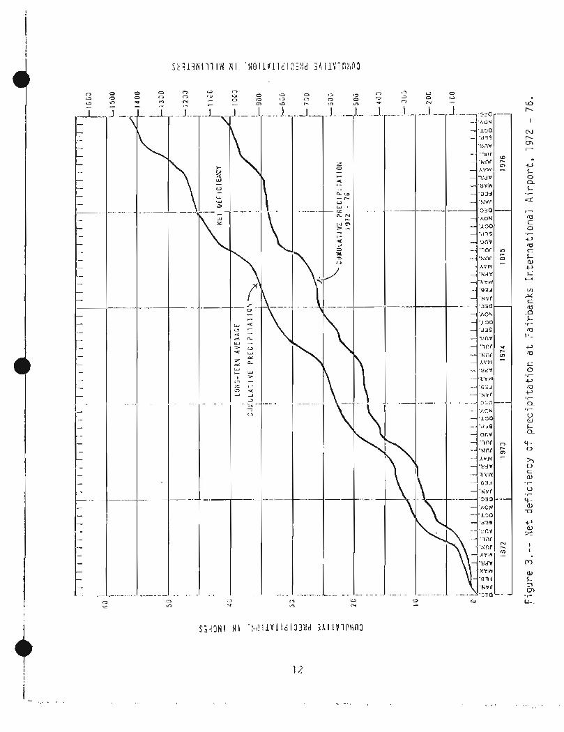
In t h e v i c - i r ~ i t y c-: Fa i rb ; , r ; k~ , ti-^::^ Katiorlal \.!:;ltii?:- Sci-vie? r;ii!iiit?ii;, da ta - -cu l l e c t i o n statior-1s a t t h c Col 1 ege T, lan~ict ic Observ3 tc)r7y, Fa i rbanks I n t e r n a t i o n a l A i r p o r t , G i l lnor~ : Creck t r a c k i n g s t a t i o n , C i t y o f N o r t h P o l e , and the Univet-si t y of Aldskci expcrirnental s t a t i o n ( f i g . 1 ) . The averag-? p r e c i p i t a t i o i i ;it t i - l ~ s a s t ? t,ior.is f o r t h e lO.-ycar- P E ! Y ' ~ o:! frori~ 1962 and 1977 i s :
Col 1 cge Magnetic O h s ~ r - v a t o i - y : 10.84 i n . Fa i rbanks I n t e r n a t i o n a l A i rpn1-t: 9.70 i n . Gi1n:ore Creek: 15.17 i n . North P o l c : 10.46 i n . U n i v e r s i t y o f AIa<?>ci exi~~ri~; i : . r i i?<l s t d t i o r i : 10 .74 i n ,
The mean annual p r e c i p i t a t i o n a t t h e FairLariks I n t e r n a t i o n a l A i r p o r t a r~d the Uriivcrsi t y o f A l a s k a Fxp~r-iii:?r;tal 5 t a t i o n i s 11.22 inches ( i n . ) and 12.90 i n . , r e s p e c t i v e l y . Ahout 60 pc r ccn t f a l l s a s rairi and t h e rcriiaindcr' a s sno;;. Strea:.if lc:.: d c t , ~ f o r ti-[;. Chznc: Rivcr a t Fai r'bi:nks s i n c e 1942 inclic;!te t i i o ariri'.ral rii:-,of; for , t h e C h ~ ; , a t-,,:sir; i s 10 .03 inti-les pc r y e a r ( i n . / y r ) . Using ail c s t i l ! ~ s t e o r G i n . / y r for- ti?;! G d s i t i - wi dc average evapc~ t r ansp i ratior~t i i , tiii s c o r r ~ s p o r i d s t o an average prec i pi t a t ior: of ahout 16 i r i . /y r f o r the er~.t : ire Ckiena River. b a s i n ,
Ground wa t e r in t h e uplands i s recfIargcd by l o c a l p r e i i p ' t a t i o r i , arid most o f t t l c : gr-ocsnd-:.later d a t a in t h i s r e p o r t were col l c c t e d bet wee^-^ 197% an:! 1976 . A cor;\;c?r-ison of p r e c i p i t a t i o n rccoi-tls f o r f o u r o f t h e Fa i rbanks -v i c in i t y vic?tiier s t a t i o n s f o r tti? f i v e y e a r s 19)%-1976 and t h e p rev ious f i v e y e a r s 1967-1971 s i~o i . : s the per iod 1972-1976 t o t ~ e s i g n i f i c a r i t l y d r i e r t h a n 1967-1971.
Col l ege Maynet i c Obser-vdtory 13.89 9 . 7 6 - - F a i r h a n k s I n t e r n a t i o n a l Ai rpot-t 12 .08 8 .3% 11 .?? G i lniorc Creek 16.04 14 .75 - - U n i v e r s i t y o f Alaska 13.87 9.31 17 .90
*Cl il-i~atol ogica1 nori;ic;l s basecl on t h e p2r iod 1941-1970 (Nation21 Occanic and Atriiospheri c Admi rli s t r a t i o n , Nat ional Cl irriat i c Cen t e r , 1977)
Accordirig t o t h e a i rpori; d a t a , pu.~:cipitat;- ion dur ing t he p ~ i r i o d 1972-1976 was 26 ptvccr-~t bclo:,, r i o m i ~ l , and 31 ~ iv r ce r i t b~!low t h a t o f t h e ,
preceedirly 5-.year periocl. T h e n e t d e f i c i e n c y o f p r c c i p i t a t i o n a t thc Fairbanks A i r p o r t fro111 1971-1976 i s i l l u s t r a t e d i n , f igure 3 .

Evaporat ion and t rzr lspi r -a t ion , col l e c t i v e l y ter7nied e v z p o t r a r ~ s p i r a t ion, a r e d i f f i c u l t t o q u a n t i f y . Evaporat ion i s t h e l o s s of wate r d i r c c t l y t o t h e atrr~osphcre from ok~cri bod ies o f water and mo i s t s o i 1 s . T r a n s p i r a t i o n i s t h e r e l c a s e o f watc r t o t h ~ a t ~ ~ ~ o c , p / l ~ r - e by p l a n t s through t h e i r I c a v c s . Thc q u a n t i ~ y o f w a t ~ r t r d n s p i r ~ f l d c p c n d s on t h e typ? of v c g ~ l ~ t i o r l , t ~ r ~ l p c r a t u r - e , h~rrl~idi t y , a v z i l z h l c s o i l n iois t~rr ; , and p r c c i p i td i io r ; .
Evapo t r ansp i r a t i on has usuc?lly been deterii~irlecl a s t h e d i f f c r c r l c c be tween pr-ccipi t a t i o n and r u n o f f . Thc c a l c u l a t i o n t hus re1 ie.; on t h c assur~!ptiori t h a t t h e r e i s no char-I~;C i n graunrl- o r surface-.v;atcr- s tou 'agc, Di ncj!-!an (1 973) reviec;.id via t~r-b\i(iig:_.t,t. s i u d i c s f o r Al a y ~ k a arid rejjor-ted es tiliidtes of evapotrarispir-atior; rar;f;iny froin 40 t o 78 pcrccr;t of pr.ec.ipi- t a t i o n . Thus t h e range o f pruhabl e evapo t r ansp i r a t i o r l va lue s f o r t he s t udy a r c a i s 4.5-9 i n . / y r . Froiii h i s own r e s e a r c h ,Dinqrridn(l971) cs tirriated t h a t 6 i n . o f wa te r a r e l o s t arl~iu?l l y t o evapo t r a i i sp i r a t i on iri a smal l wa te rshed near Fox, Alzska ( f i g . 1 ) .
a The c i t i e s of Fair-banks and Nor-iil Pole and t h c niil i t a r y bases ( E i e l son A i r Force Base and F o r t W.nir1vi.r-ight) have pub1 i c suwcrarjn systeins 1,lost o t h e r a r e a s a r c servecl by on-s i t e systoriilr c o n s i s i i r ~ g of a septic t ank and s o i l ab so rp t i on systei:l ( s c c p a y t ? p i t o r l cach f i e l d ) .
S t a t e r eyu l a t i o r l s r cq i i i r c t h a t on--s i t e sewage-disposal systar!is c o n s i s t of a s e p t i c t a n k o r p a c k a g e p l a n t and a s o i l a b s o r p t i o n system. In a s e p t i c t ank , s o l i d s and l i q u i d s a r e d e t a i n e d s o t h a t b i o l o g i c a l p roce s se s can decoiriposc the mix tu r e . A rcsiclital l i q u i d t h e n overflows t o t h c seepage p i t where i t i r ~ f i l tratc::; i n t o t h c ea r th rr!;:tci-.ials. Cesspools t h a t c o n s i s t of a s i n c , l r por-nus-walled c r i b n i ti) no s c p t i c t ank a r e i l l e g a l undcr Alaska s t a t u t e s .
In recogn-i t i o n of the potential f o r grourid- water. pol 1 u t i o n froin sewage-disposal sy s t e r~ i s , t h e S t a t e of Alaska h;is e s t a b l i s h ~ d ruy1.11atior-1s recluir ing ncl l ls t o be locztecl no t l o i s than 53 fi ff'iiili a s c c ~ t i c tar rk nor l e s s than 100 f t fror;i a socpagc p i t . T h e Alaska Ucpa,.trii,>iit of ' Enviror~nierital Conserva t io r~ a1 so may r e q a i r e a devclopct- t o ob t a i ri p e r c o l a t i o n t e s t s wich nicasur?, i n pl a c c , t h e a b s o r p t i v e c a p a c i t y of' s o i l s .
S e p t i c - t a n k e f f l ucn t has a high pol l u t i o n p o l e l - ~ t i a l becausc rrlany ~ h ~ i r l i c a l s and triost detergents and v i ruscr , a r e no t ~ ~ C C I ~ I I ~ O S E ' ~ o r ril-ir!oved i n t h c s c p t i c t a n k . After- t h e effluclrl t flo4:is froiri t h e sckpage p i t i r i to t h e e d r t h m a t e ~ - i a l s , t h e ciiet-,~ical and b i o l o g i c a l cor ls t i t u e n t s a r c depl e lcd o r charirjod through chei;i i c,?l ancl pi;ys i cdl .i r i t ~ l r a c t i o r ~ s wi t.11 t h e sut)si~r-far:c~ er l v i ronix:nt . Reduction i n conccrl t r a t - ior ; o f pol 1 utasit5 iri t h e e f f l u ~ r i - t i s p r i n c i p a l l y causcd by pi-~ysical s o r p t i o n aricl by d i l u t i o r l . Unclcr c e r t a i n

condi t ions , di~r;ont;;iliiriatio~i of 'ihc \,/as te writer rii~y not be c:o;.-lpl r> t~ before the e f f l ~uer-it rtiriches the shal low nrjuifcrs o r v ~ a t c r ~ c l l s ( ' . c h ~ ~ e i d e r , 1'370). Additional na tura l changes in the cha rac te r of e f f l u ? n t -fi,cm s e p t i c tariks depend on tile r e a c t i v i t y of shallow subsurface ina ter ia ls a t prevai l ing tciilpet-atures arid tile r a t e of (2fflncn t ~!-io~:li;i?nt in these matci-ial s .
Attenuation o f pol l u t a n t s in r;r-.piic-t,i>iik cf f lur .n t iricl-crises wi th the tiil:e o f t r ave l t i i l - ~ ~ g h su r face [:;a t e r i a l s . In the satllr2i:p-j i .nnp (below i h c w a t e r t a b l c ) , the r a t e of t r ave l (.:,?per-~ds on the r,r-ound-water gradient and the t ~ y d r a u l i c cond~rz t iv i ty o f the ma tc r i a l s . I n the unsaturat:cd ~ o n c ( t h c zr~tie d b o v ~ the water t a b l e ) t r2vel time depends on tile h;/dr;lulic co110uctivi- ty of ii laterials ~ n d tlie depth t o tile v;ater t ab le . Absot-ption and biological ac t ion a r e r-lioi-e et'-iective in iittc!l!~at~irlg po l lu tan t s in the unsaturc?i;cd zone "than in the saturated zor-ie. Also in tile urisaturatcd Z O I ~ E , l l : l J ~ h of the e f f l u e n t i s absorbed by ea r th rnatcrial s and dispctrsed by capi 1 l a r y forces in 01-dcr t o s a t i s f y moisture de f i c i cnc ics in sur-face sedi~ii?nts . I n order to insure t h a t e f f l u e n t i s c;:posed t o ac?rnbic rlr.igrad,tion before i t rt?ac,ihils ti-~e viater tat31 e , s t a t e ieegul a t i o n s i:)i*oi-libi t tile i n s t a l l a t i o n of a s o i l absor-ption systciin t h a t dischar-gcs e f f l u e n t c l o s e r than 4 f t t o the water t a b l e "as rr~eclsured during ttic season of the year wi-th maxi~i~i~tn v:ater t a b l e e lovat ion . " Sta t e regula t ions a l s o p roh ib i t the i n s t a l l a t i o n of a s o i l absorption systein i n permafrost ( S t a t e of Alaska, 1'373, T i t l e 18, Enviroriii-,cntal Conservat-ion, chap, 7 2 , I , iast~\ , :ater D i sposdl ) .
The Tanana River der ives approximately 85 pcrcclj t of - i t s annual discharge from the Alaska Range a n d 15 percent frorn tit? Y u k o n - T ~ I - I ~ I : ~ uplands (Anderson, 1 9 7 0 ) . Eecausc a l a - g e pa r t o f i t s sti.ea~!- flow i s ft-oin 11:el t i ng snn\.r arid i ce in the i ; l o u ~ ~ t a i n s , an i n c r c d ~ ; ~ in ti:;-;i:~irat.ure S Z w .,hl_s - , . A iricrcascd cli.;~lial-ge ( f i g . 4 ) . H i ~ h f low in tile Tzr:?.!-~a R ~ V C I - a t Fail-hanks usual ly occlli-s ~dcit,inij 1-~ot, d r y 1 ; ~ a t i l ~ r vit:cn sric>;:,,.~elt in -ti-ie i~iountains reaches a ~!;axiii-:!~m. Rainy vrilatthcr in the basin i s us~.ral ly acco;.;.ip<:riii.d by 1owt.r tci,iper-atul-cs a n d a cjecredse in tile r a t e of s11~;rll;elt i n t i i u i:iouriCai ns. An incrt:lc?.;e in t h e i-ai tifa1 1 coinponent of stt-caiilfl ow i s 0fik211 of-:set by a dccr-,&-:r;e i n tiit. t ;~ io ' ,~ : ,? ;~l t ca:,8;o!-~ent.
Snow and i c e in i ; i le A 1 z,ska Fange a c t a s reservoirs, sioi-ir,~cj k:atc?r during yea r s o f ahundant p r ~ c i p i t a t i o n 2nd re leas ing i t during warin, dry years . During prolonged periods of be1 obi-not-i;lal preci pi.t(it ion, discharge of tile Tanana Ri ver rr:ay reer::ai n i7oiA!.;al becsusc sno.,,viiiel t ~~i i ;p[ :~lsa tcs ,for lack of p r e c i p i t a t i o n .

Figure 4 . - Colnparison o f d i s c t ~ s r g ? of t h e Tanana R i v e r a t F a i r b a n k s w i t h tei;i;~crt:ture and p t , c c i p i t a t i o t ~ a t Pliy D e l t a , A u c ~ ~ ~ s t and S~ptc!i ; t ! i : i - , 1 5 7 4 . B i g Dcl t a i s n c a r t h e rlloun t a i n s aboi.lt 7 7 m i l e s s o i l t h e , ~ s L o f F a i r b a n k s .
I.loxiri:u\n f l o b ~ i n t h e rar:c?t?a River ! ~ s \ ; a l I y occurs i n J u l y , and the rilini~i-ium flow occu r s i n 1 d!c ~ r i r ~ t e r . Ilr?ar~.-dai l y rlischarcje of the T a r ~ a n a River a t Faii-bdnks has r(:l-iyed from 5,000 cub i c f e e t por sc;c:orld ( f t 3 / s ) t o 68,000 f t 3 / s s i n c e 1973 ~ i l i i l n the claging s t a t i o n was c s t h b l i s h e d . Avcrdge d i s c h a r g e i s about 20,000 f t 5 / s .
Flood- f r e q ~ . : ~ n c y cu~ -v (? s d e p i c t the fr-equericy wi - t h ch a s, i ilgl e f l ood (:vent w i l l t.ixcr:c.d a g ivcn d i s c h a r g e on t h e long--tcrill avc r age . Thus a 10-year f lood can be expected t o be equa l l ed o r excccded on the avcrage u f once every 10 y e a r s . Figure 5 illustrates t h e f lood- f requency cl.ii'ves f o r - the T;:nana River a t i;cnatia and t h e Chena River a t Fa i rbanks . (Tile i:;:iiijna r e co rd i s v.;r:.d r7a thr r tila11 t h e Tanarla River a t Fa i rbanks hccause t h e pe r i od u f rccord i s t o o b r i e f a t Ihe l a t t e r s i t e t o d e p i c t a r e l i a b l e c u r v e ) . The 1967 f l o o d pcaks c:xcecd~d the u-el iable p a r t s of b o t h cu rve s .
An adrli Lional ,flood i iarard i s n o t rcprcs(:nt.c.d by these c u r v e s . I! ~ ~ e c a u s e f l o o d - - l - ' ~ ~ i . : q u ~ ~ ~ ~ ~ c y curves a r e I-i,ised on d i s c h a r g e , -!.hey d o no t p re - s e n t a p r o b a b i l i t y o f f loodi l ig r:a~rsed by i c e jarils. Such f l o o d s a r e caused by c o n s t r i c t i o n o f tile cl~ariticl arid thus lnay occur a t tiloderate d i s c h a r y c s .
Ci,[:-na Ki v e r . . . - - --
The Chcria Kiver u s s a l l y lias t i , ~ pe r iods o f high d i s c h a r g e each y c d r , i n Ilay arid ,q!lgl~st, o;.riricj t o spi-ing runof f and t o r-ainstorrns, 1-cspticti vi:ly. S i nce 1945 :;i;cn a con t i n!lous recorcl of d i schar -ge I-)egan, tile ~i;c:xiiii!itil , , t ~ ~ o i + d ~ d f l (> \ , / :.:as 74,(00 f t 3 / s on Aurjust 15 , 1967, and the rninii~iur.1 :.,as 1 2 0 f t 3 / s . i . l - 1 ~ 1at'ic:t- occ:ltr-r;'d c!iiritig l a Lc w i n t e r of 1953 2nd 1958, Tiie 3Vr11 ' ,?k5? ~ : ' I j ' ; ~ i . d ~ - c j ~ ! i s 1 ,493 . f t 3 / s .
The flood-frilr;;icncy curve fcjr the Chena River can he p r o j e c t e d wi th 501;ie ~ ~ r l f i d e r l c e t o t h e 50 -y(+ai- I-ccirt-t-(3nce i n t e r v a l ( f i g . 5 ) . However, t he Chcna 1-akes ddm i s i.!esic;l-~cd t o diver- t f l ood wa t c r s 3roi.ltid t h e F a i t.ha11ks a r c a ; a f i v r i t s c::l,.pl c t i c n , t h e flood-frcqi:crlcy c:urve w i 11 no lo t - ,>er p e r t a i n -to t h e r,~-oli:cted c i rca.
Ground . \,;a t e r . -. - -- --
The p a r t of t h e a l l u v i a l ciquifcr considcrtld i n t h i s i-cport i s Scil11tl;~cl cjl-1 - t h p r-~oiiii by I-.:~~j~-i:lck of 'ihc Yi:l;on-Tat:<t:a uplc.nds and i;ri t h e s a : ~ t h by Lhe T a s ~ n a Ki>,,:rr. I n t i it? f l ~ ~ C I - - p l dill hi-(la, 91'0iind \;ater i s 2e1-\era1 l y unconfi ncd, t h a t i s , i t i s u n d ~ r wa t e r - tab1 e c o n d i t i o n s . I i o ~ e v e r , where t h e dcp th t o t h e wa t e r t a b l e i s l e s s than t h e dcpth o f a~ inua l f r o s t p e n e t r a t i o n , f r ' ~ i , ~ ~ l ~t'outld ifjay form a seasona l con f in ing 1 aycr . Peri l~af i -os t a1 s o fr;l-,,:s (3 dic;lirr.titili~ioirr; c o n f i n i n g l a y e r .
Gi-oi~r~d 3,~~ci:,i~r i s ~ - ~ : ~ : i ~ ~ ~ ~ 5,:ij ; ; ~ . i !~ ( : - i ; - q l l y by i ~ - i f i l t t ~ a t i o t i '7i-1jtjI th? Ta1;ana River and, t o a It?.;s;ir ~ x l i ; n t , fro111 t h e Ci~ena River . A t r ~ i o s t

D I S C H A R G E If4 C U E ! C F E E T P E A SECDHD

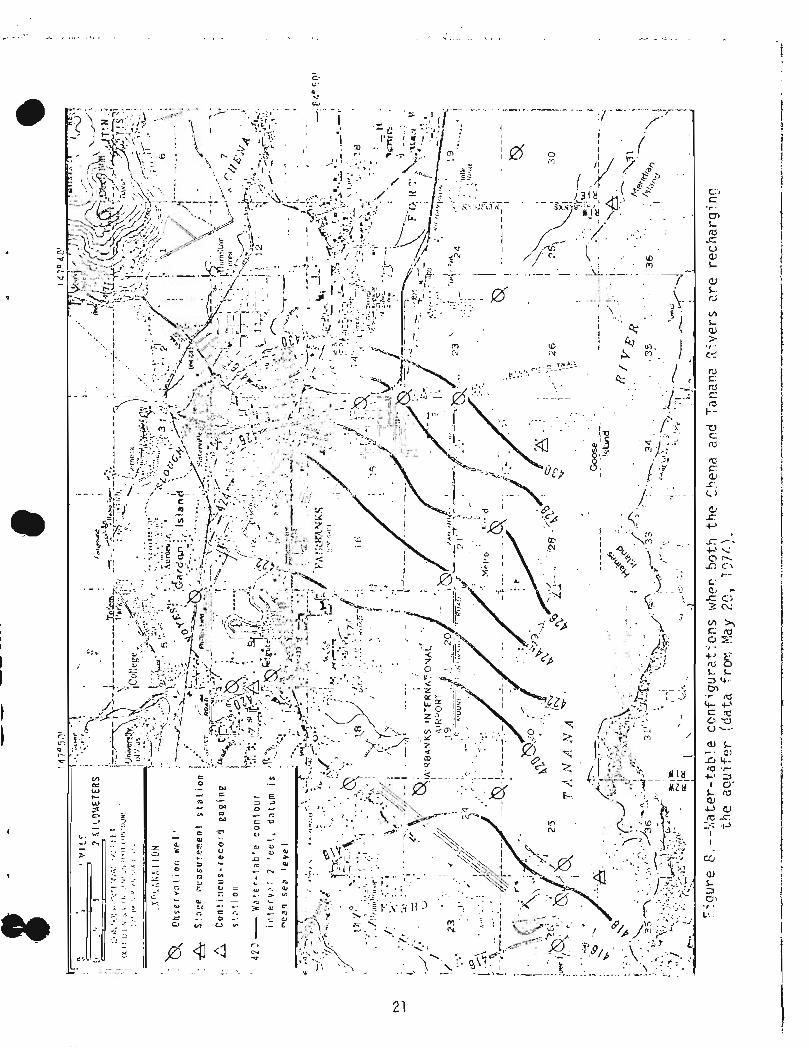
t i l i ~ c s , llie vidti:r sut-race o f ttie T ~ n ~ r i a Rivcr i s i.opr~yr-cphically liigher than both t i l e Ctiurla Rivrr l ~ n d i t s t r i b u t a r y , Cti{-na Sl ro l rgh (I;c,-eafter c o l l ~ c t i v e l y r e f e r r r d t o 4s Ihe Ci~t.~la systt'in). :,'iien t h i s ncclrrs, tlre aqu i fe r i s rec:harcjed by i.hc Tatiana River and dt-diricd by the Cheria system. Such cotidi t ions ai-e i 11 u 5 t r a t i l d in f i g u r e 6 . Tile flow dirclct ion, which i s genera l ly in the d i r e c t i o n o f s u f f a c e drainage, then trds a c ~ l i ~ p o n ~ n t fro111 the Tanaria R i v ~ r t o the C h ~ n a system. Tile :e,ater t ab le a l s o slopes a\piay from the T ~ r a i l a Kivc-r ( f i g . 7 ) . P:t;en t h c Cl-~cna Kiv~rr i s high and the T a n a n a River i s low, a ~.oridi t i~,n C ~ I , I I , I O I I rjuritig spt-ing ri~rioff crich y e a r , both r i v e r s t,~ay coi-liribute v!atc-r t o tlic aqu i fe r , and the d i r e c t i o n of .jr30und-xdter flop/ i11ol.e c lose ly cot-rcsy~onris t o t h e d i r e c t i o n of su r face drainage ( f i g . 8 ) .
Before one can quani i t ,a t ivcIy j j l-c?dict aquifer \.ec,punse t o s t r e s s cond i t ions , such as ti-lose calrsed by iic-avy pl~l-i~pi~-ig, drainage d i t c h e s , and o t h e r a r t i f i c i a l cons t ra in t s -to natural flow, the capacity of the aqui f c r t o s t o r e and trancmi t :,,a t c r i-iiust be (lei-erir~iricd. 1-hcse capaci- t i c s , t e r ~ i e d the sl:or(j.lge coefficic.:nt and tl-ar?s~i~i s s i v i t y , resl:~t:ctively, ar-e of ten c?stii:iated f rc)!il p!!;lip t e s t s . in tile Fait-.l~;nks a r c ? , puinp t c s t s have pryoven iiicor?cl usive in acctlratcly defining illc?se v a l ups. tiowever, on the bas is of pui-;ip t e s t s a t Fort C!ain\~rright, Cederstrom (1963) ~s t i r i l a t cd the transrnissivi t v i n t h a t area was "scver3al hundred thousal-td gal 1 ons
I I p (? r day pt'r foo t . One t e s t described by F ~ u l l - ~ e r (1961 ) i l l u s t r a t e s the pro1 i f i c l:,:paci t y of ti-](? ,:i.jui f ~ r . A vie1 1 a t F o r t ilai I-,;:right was p~iitlped f o r 24 !-:o~.rt-s a t 1 ,500 ? a 1 lotis per iiiinute (gal/min) . During ~)ut.i.iping, the wci'ier level in tiic : ) i ~ l l iiecl ined only 9 ft, and i t recovered t o s t a t i c l ~ v c l 15 seconds a f t c r pimping cearqcd. In a siriiilar t e s t a t Eielson Air Force Base, the vister level in a we1 1 ~:i\~~iipcd f o r 24 hours a t 1,500 qal/iiiin dccl incd 26 f t u n d r-(:~o.:r:.r.c?d t o sl.ai,ic 1 fve l i ~ i t h i n 30 stlcnnds a f t c r puinping c;;?sl;t?d. I n Sot i ) ti.,estrl "i.i?sl:.s, ~ . ~ I L S di-;:.,,,.!i.N,,~:n i n tiif: a q g i f c r V J A S 1 c s s than in t h e );/el 1 s , bc-cc:lse the v::.l 1 s \.;il-P [;i:i,-,;;cjd f ~ r - b::yl/or-id the capacity of tile scrc;:-:IS t o ti-,.?nsini t water frziiii ti12 z q u i f ~ r . !,!:,in i b i s occurs , a s i g n i f i c a n t p a r t of the iiieasurcd drav~tlovin rnr:sul t s fr-oin scr-ccn losses .
For designir-ig tire Ct,cna Lakcs Flood Con'it-01 PI-ojec t , the U.S . Army Corps of I-:ngi 1;er.r~ ( 1 374) is t.iir;at~?d ti-ie thydt-aul i'c c-:s!idlrcti vi t y o f the allliviurn t o be dl:o!~t 1,000 f t / d . For a r ; 0 0 - i t - t i l i c k ~ q u i f e r , -Li~c dpproxi- \,late i l leasurcd th ickness a t the Chena ?i vet- c!;rn s i t e , t h i s corrilspoi-ids t o a trarlsrnissivity o f 600,000 f e e t sql-lared per day ( f t 7 / d ) .
Effec ts ................. of nod i f i ca t ions - .... t.o Lhc h\ld~-:!l,?yic syst,ein ....... J .... - . . . .
Ci:r,na . . . . Lakes ... -- Fl ........... nod Crjntrol ;~-oj:l:.ct . . . . . . . . . . . . . . .
The Chena Lzkes Flood Control P ro jec t pr-esently being cons t ruc t - ed by the Corps of Enginet?rs, U.S.Ar!-iiy, w i l l c o n s i s t pt,ir!larily of ; in eartilf i l 1 (!r?i~l il:r'o~s t!i? C!;::lia ? i v ~ t - , a li...:~-e a l c n g the I:oi-ti1 bank of t i l e Tnr iu r : j River, 2 n d c,c:~.~:~ral ; : r 7 ~ i ! . . : ! j ? iii.i.r:/-,i?s ir-lcii le 'ill? ; I)-otect- ed a r ea ( f i g . 9 ) . Irrider- i . i ~ s t i:,::i;di'i-iz~ls, str-c:ai.iflo:zi l?\iill ,.lot be

h A . - urn W b U>Gr E) L - 7 - c rri .r-
-ST .r nL U c.> 31 at N +)
L rG h 3
W r - (II
a , . C 1. .r

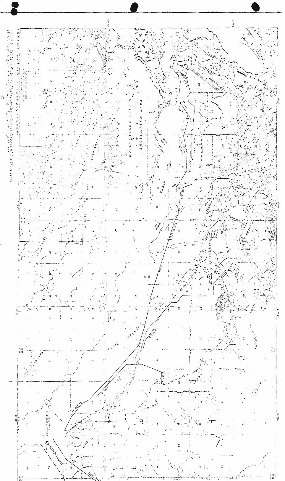

ii,-;,::::d. Ec:8e;i:ver, b ; / i ~ r - l f i c ! : : . j c , j r . t l i ; i c ~ : : < c~c, : IJ~- OD t i ; " C'1-.::.;. ;liv::f, v!::fpr 1 b I d > i I . I f . , : I f i i - ie i l , , ; : ~ ~ : , ~ - ~ d i i ~ ~ ~ i t h r - ~ z i s f i 1 l e d , p;+t,::r- 1 be d i \,;.r,t.?e Li~!-c,.j;!-, a spil1v;c:y i t\-,? Ta,- , ! c [ , 3 - -. . R i v ~ r - . Irl oryd?i- t~7 pr-f: 5 1 - 1 t t i l e T~17:1;2 RF ?..:I- f rii~il f l ~ i : ) d i r - ~ g t h e p i -u t p c t ~ d a r e ? , a l e > ~ : ~ k;i 11 be (.,;/-IS : ! - i~c t ? d a l ~ ! i y i t s r , . l r - th bar-,k f ro i r i
r' . tk,c C;,t:t;a Riv;:r da;,; t o t l i c n- ,ou th o f t i -16 Ci.~;r,a f i l v c r ar-!d c x t::-!di rig 3 m i u ,p ; - .- - , .
r i a I I r 0 t C 2 , . D~-? i i ,~ :s . i r;i!cii-:5 w i i h i n ti-\? p.-t:b:.cted arcs ar-e d::-;j?r~;.:d t o j r i ! :?~-c!?pt 9!-cA:;d 7 : j t.!:r- s!:;>;.)'; ny uri(!er I (:>,;: z:,,j l ~ ~ ~ c : ~ i t i t I I i 1 o r T I E I . Dl-a i r ,age d i i,~:i.i+j v ; i 11 hc e x c r . v a t j i j o;; til? i j : . : . : - -.,;?~IL y r - ~ jr~?..,.::i.~:.r- tc:?.;l P , 5r1d gr7c,:.;i;i: :.;atcr st.?pincj i n t o t t - i ~ ? chi:,;,ri?l v:i 11 s u s t t i i r ? f 'l c';i t i l :. i ., l~ j ; - ~ o : ~ i t i l e y e 3 r . I n t h i s r e . ; p~c t t i i ~ y v i i l l b;; s i i ; . i l a r t o Ci-i;.:ia Sloi .19+, v!iiicii no:.! d r z i t n j gr-ci ind v i a t c r ~ : i t h i n a s i i ; ! i l cir- 2 rX;_2 .
Ti;? st[>? w a t c r 7 - t ? b l c g ra ; l i e r - , t t:~t.:.:::ti t i i c Tar,;,r-!a Rib,?[- cnd the d i t~:;-~,:; ?;ill cc3u5e h i g h pill-? p:-?:>sur.es i n s o i l s on t h ? p l - ~ t ~ ~ . t ~ d s i d e o f t i c 1 c.c.:.c. Accc-lr-d-ir-I~ t o C ~ L ? t - s ~ - c r i ( i n Cosps o f E r~y i~ ; cc - r s , 1974 ) , SE;; ,:;-I' i ;r;<-rrr- t i ~ ~ ; 1~';:-p c i l ! ~ ti? ~-.x;ir r t e : ; t o c;,*.~se sccps, p i n b o i l s , and
. I I , L . . . C;I.IIC t>:,:!!3, 1. l:;:-,c.r> p ~ : - l , . - . . ~ . . ~ ~ i l - 1 i - 1 : ~ ~ EI-2 h i ~ ? i .
S i g r ~ i - r i c o r ~ t r . o d i f i r e l i o i : o f ti)? r,?. ti:lAal gr-;i!i!ll-:.;;: tcr- flc::.: ca!.:st.r? by I i I f r 1 1 5 r t i 1 1 - 1 G , r t i f i t . . A k ; ? l i n , - ~ l - ti: Tcj1.t ' ,~ . '~ i r - l :~ , ;~ - ic i ; l s:,!.riil FI,:.,,-::- p 1 3 r-; t 1'1- ':, 'l'., ,: $1 ;: v :. r 2 r;i j 1 .i o 1-1
fi:!l]pii:, ., -. i n a zPt-)j~,;.i!- ; , . T F ,.; -. d l - - , . . , . .,., 1 - :;r ~ : l - ~ ~ : ~ , l : ; - ~ ; ~ i!-, &I- , C , ~ : ~ = ~ ~ - \ S -
t i o r i :,;ell 20/: i t a:.;?y v:as less t i ~ ; i n 1 i n . (f'~.i.il;i~:r, l?;r:81 ) . F , = . , y - - ' , : -.! 611
I Fui-~p t c s ts a t E i e l son A i r F o r c e B z s e , Fort la:ai r-:';:t-ic;il t , ar-ld t h e S U ~ A * ; ~ Fair ! j?nks a r c a , i t appears t h a t such r ~ i ~ g l i g i h l e e f f e c t s a t7? t y p i c a l o f
1 rriici-1 o f t h e f l o o d p l d i n .
I . ;clcl iTicat inns t o t h e n s t u r a l gr-sl.:r~S--:.ia'ic-r syste::; cr!us::d by iii_avy pL'.. - ' to d ,,, . -
1 ' I;) I 1.1 t i a , d t ~ r E X C ~ V ~ ~ ~ O ~ I S k i 3 ~ ~ t ;~:?n s l i g h t . Cot-15 i r u c t i o n - s i tcl d ~ ; * ; ~ t e r - i r r g u s u a l l y docs n o t depi-iiss tiiti ;-:aicr t a b l e n-;,re t h a n a t rout 10 f t , a n d t h e a q u i f e r i s c r i i t . : c f i l y n!-,r-e i i . isn 309 f t t h i c k . Dc,..;:t,ering t i i i l r ,? icr i -c d o 2 s n o t d2 i r ; asc t i i c s?t!.ir-=L~:d ihicl..r,~::ss 0-f ti).;- c r ; ~ i f ~ ; r by F;IC'I-L t i t a n a ic,;: p;:rcerit. P,-- .L?'I .<E th~7 yjc-ld t o k:?1 1 s i s i n rj<r.t rcl a t e 6 t o t h e t i ~ i c k n e s s o f s a t u r a t ~ d i : ia ie r - ia l s , rricist w l l s a r e r i o t s i g r r i i i c a n t l y af.fecied by c u n s t r u ~ t i o f l - s i LP d w a t ~ r i i i g u r l l ess t h e ~ : a i c r t a b l e f a 1 1s be lop i t h e leve l of th. F)id:iip i n t a k e .
I-;ast d r i 1 1 ed v;?l 1 s ilzx;e p: i ! - ;-J i r i tr^l:~-s 30 f t o r r17orc he1 o i l t h a k:a t e r t z S l c arid a r e a b l e t o c i b t i i n a:!,?q!i:.te s:;2pi i e s d ~ ~ r i n g di-::!2tering. Ho!.:sver, r i .zr l j do:-;estic we1 1s c o r - ~ s i s t of s a n d p o i n t s d r i v e n l e s s t h a n 7 f t i n t o t h e s a t u r d t c d r i \ b t e r i a l s . D ~ : ~ a t e r i ~ n g !;lay dry u p sol.iie of these w e l l s . Dur- ins t h e surnj.:er and f a 1 1 o f 1916, f o r cxal.;:pl e, c o n s t r u c t i o n de:.:atering - a l . ~ r i ? the Ci~cr;;? P,iv~r d2:i-i 2nd s p i l l:.:?j/ ~ > r - o J i i i ; l d a l o c a l 6cp t -ess ion i n t i l e :.::t~r tzt l le i n tii? a r t a o f t i 1 2 spil l l ..: l :y ar-id tile r r i~ j in t ) a ~ - r a v ~ p i t .
The p!.illlpi n y rTat.c f o r d?\:iii-t;~-i n g r . ~ ; t l ~ I i ~ d a r~;axi!:?urn o f 85 ,01:J(1 gal 1 nns pfr i i i i~ i l i i~ (gdl/iriin) frnrn t h e s p i l l ~ i a y cotis t i - i~ct ion 31-pa ; tnd 40,090 $al/rr~in fr-on1 'ihc rnai n borrow p i t . ?( .~,!IP I I O I , , ~ - : ~ . ; ; ~ J ~ - I ~ ~ S ~0i1.il11 a i 1 7 ~ d of 1!ic11 f l ) r l ~ t , i ~ ~ r l i I-lg i v ~ l 1 s tJut-i ng t l ~ i s period.
Drainage p r o b l . . . . - -. er~is - -- - - a f f c c t i . - - ny . -. d e v ~ l - . opi)icnt -.
Ci i i_~id Slough i s s i ~ ~ i i l a r to ttic i-li'opnscd flood--ci>ntrul ili1.r;hc.s i n both f u n c t iun arid 01- icnta t ion . I t i s appt-~xir::atcly para1 1 e l t o , and ,froin 1 t o 5 mi fi-crn, t h e Tar!i:na Rivc2r. I t i n t e rcep t s cjt-ound water flowing northward fr-om tiit? Tzr~cr:a River znd d i v e r t s i t t o 'the C h e n a Riv:?r. E C C J U S C t l i ~ pri:,:;ii.y r c ~ u l - c e o f i Ls f lcw i s gi-ound water , i t flows tiirocrghout t h e \ v i ~ ~ t ~ : r , :,,I-~~:ti t h i c k c$ici-flow i c e , o r f3u.Fcis, occurs i n soiiie reaches . Ac(:orili I - ~ g 1-0 ~-i:i:o~-,ds ft,,um the A 1 ilska D::pai-t~ijct~t of lli ghways ( M i 1 l a rd Kaklcr, 1976, or-a1 (:cjiii,~i!.rn. ) , i hc rol-illation of a u f e i s i n Chena Slough i s accor;ipanied by a r i s e in ground-uratcr l e v e l s . The a r t i f i c i a l l y 1 ui,:er-(:!d v:ater tabl e ricar Lt~c l i r - ~ l j ~ ~ ~ i d di tr~lies [nay bz subject t o s i m i 1 ar s ~ . a ~ ; o n a l f 1uctl.ia-Lions. Fi51. i re 10 i l 1 ustratr?s t h e l?p;~clrent ~iieci~anisrn by :,:i-~ich t h i s ~ri i i tei- r i s e in :,:;lter- tabl e or,cur.s. Cui-incj the Sv: ,~, :?r , tile ci-i;t~-,~iel d ra ins :*:ater f I-oin tihc grn!:nd, ,ind tiie v:ater Lab1 c 51 TIJICS tc1',,:3rd the flolving stream. During t h e win te r , the chlinriel i s choked w i t h i c e ar-id i s l~riahle t o e f f e c t i v e l y drain the ground water. ,4s a r e s u l t , the 3.,:af e r t a b 1 P r i S P S .
The pro,:'osi?d (li*;ii ri;+?c di t( ; l - ic~ w i l 1 car.rsc a siinli l a r local d?prt.l;siun of l-iic : ~ ~ d t l : r t;ihl e cjuv.i rig t h e su;>::,;c;r. C ~ n t r a c t o r s or koii:~~owners h i ~ i 1 d i n g in the v i c i n i t y o f Clicrla Slo:igh or i;he drainage d i t ches n:ay be unavrcire b h i i t high v:ater t d b l e ccl!:ditions (:an occur during midwinter. As a r c s u l t , basi>i;;?tIt,~ ar-til otI.i!ir sub:.iit-facc si;i7ijctures t;:ay kc c.il~placcd near I I i I 1 Ti-~r:se !.;:y b:? I:? -,:gcd by yi-ound-water scephge ciiir-ing t h e Y, i1i'ir.r. S111;il t i - ,-,id;! i-;(;s a1 I ~ z d y ui:(:sr-r'ed a1 or-~g Chena Slliirgh iic._,it- Pl a c k Eoad, :,iii,t.e in rir,e c-;:se a ? i f e i s ii)tit.i!!nt:id the I.asc~!izrit diiring t h e winter (cover p h o t o ) .
The water t a b l e a l s o 1'luc:tuates in t-esponse t o cilanyes in s t age of t h e C h ~ t i a and T;,nzl-ta 2ivcli-s. These f l u c t u a t i o n s , v i i ~ i z h a r c I-:cn-ii-!ionly a s i,-,l.r~:h ;is 6 f t r:r'ar t l ~ e C/l?!id Xivet- 3i1d 4 f t I-iE'Fir t h e Tznana River, i i r E
at,irtlualud w i ti) i ticr-casing tli s t a n c e fl-orii tiie i-ivtzrs. Substrrfac:e s t r u c t u r e s er:!placed during periods of low water l a b l t l s n:ay cxperience seepage dut-i tig ~ I Y ' O ~ O I I ~ ; ? ~ pcriods o f high s t3ge in the r i v e r s . Several coi;iiiicrcial bui 1dil:ys in t t i ~ cr.iiri2.ral t ;~.~sincss d i s t r i c t arid in G~-;~?hl ( f i g . 1 ) have I rji.,ound :.aLzr 5;:ii.:,:ge unt!::r .r:lch cs!-i~lit-ii.lris. Such i z : - : ?age i s ,::~oid,ble " i f bui lding 6 ~ s i ~ 1 . 1 ; t z k e it- to ai_coi.itit the pt-obable r:,n:je of l.,.,a Ler-iiible f l u c t u d t i o n s .

o a) i r ' v-- -r: c.3 v, 4J
fi L. L.. L PJ a1 GJ w cx K + j v . t 4 ' a) r o w 6 L . r ffi 1 7303-v
I I
Q\;al i ty o f water . - - . . . . . . . .. . ---
Qua1 i t y of ~ r a t e r ~ ~ l u s t bc tliscussed in terrils o f -the use f o r wi-rich the via t e r i s intended. For exaritple, t i lcre ri:ay be no 1 iiiii t jjr-cl;~ri bed f o r the ai~iourit of s i l ica in drinking \l;ater, y e t Even 1 iiiill 'lgram per l i t e r ( I ; I ~ / L ) of s i l i c a i s too w:lch foi- f e e d vratzr t o I-iirjh-prcssui-e l ~ o i 1 e r s . As z n o t l ~ e r exai!-ipi e , tile accr?ptabl e cr~nct:i~~Lr*a L i o n of fecal coliform bac te r i a may be tr?ui:i~ hi91,it'r in \t;at;er used f o r t-ccreational purposes (si./it-ilij~i ng and hoatirlg) than f o r drinking water. For- most p roper t i e s o r const i tu:! i~ts , the most s t r i n r j ~ n t rcquirc-ii~ents a r e f o r drinking x a t e r , and i t i s i n t h i s c o n t e x t i l lat -the t;c?tural--wat,er charac- t e r i s t i c s rtY'S ~ ~ s c ! J s ? ? ~ i n t.hi3 Yo1 1 ~;'(i!:g j : > 1 * i g r a p h ~ . Ijrll cis5 ~ t h ~ i - ~ i ~ e spc'ci fic:d, the terrn " d l iriki iig \,;.:tr;r st;Ai-~r!c,rrls" I -efers t o those defined by the t-:nvi ror.i~,~cr.~tal Pi-ot,t?ction Agtincy (I-.?A) ( 1 9 7 5 ) .
Surface lvatcr - - - - - -. - . -----
The T d t i ~ n a Ri vcr cant-ai iis il;rd \,;al:cr of c.i;l c i uiii b i c a t - h o t l a t e type. In 76 ~ u i i ~ p l o s c o l l ~ c t e d a t r:z-llarla, tile dissolved s o l i d s rsr:t]cd from 76 t o 130 mil 1 igl-arlls per 1 i t e r (i i lg/ l") . A 1 1 c:i~t.~iiical t:onstitilents e x c e p t ; ; ,angar-IPS~ arid cadlni u i r~ :.,ere w i t h i n IIPA-~-il.coii;:~icr~ded ~naxili~unl 1 eve1 s f o r riri nki ng :,.rat,er. i4anqat;i.r;~ concentra t ions were a b o v e the r-ecor;ii,:ended r :i~.ii:~.rin of 0.05 l ; I : j / L i n a1 1 s i x s t r ! p l ~ s analyzcd f o r dissolved iiielals. Foirr of tile s i x 5?;,:pl:~s cc~~-~tzir-~c-d l ? s s than lilt r.~~;oli;l:lilndcd ~i:axin~~~ni of
, . 0.01 ti~g/l- of c1i~solvc.d (:zl.::-,ii .!ij.~; ~ ~ c . : ' ; Q ' J c ~ , in tv io ~ i l i i i ~ l e s , l.hc cacilriium c;cjnten ts vccre 0. 1 4 at-~d 0. 32 :;;g/l., icore than 10 tiriles the reconii;i~nded 1 iini t f o r d r inki iig \,:at,rlr. S c c , ~ s c ciidiniutn i s toxic and the Tanana River i s tl:e soul-zc? of g r o u ! - ~ d \~r;ii;er ri:>;r- fT(ii t-!:aliks , acid i i ; i ona l riiiiiipl cs a r e !>ei ng col 1 c:ci.r:d 2 n d a ! l < i l ~ ~ : > d -FOte (;?,+.,ii ui i l .
Iv;!rch of t h e c.usi>.lF~G~?d ~: i tc - ! ;:,,\:-i~t in t h e Tf ir ,cna Rivtllr cot i s i s t s o f g l ac ia l f l o u r , i.:hich i s s i l t - - ~r-id c l ay-.si/f:d rock p;ir,,,iicles pl*:)rluced by gl a c i c r s . The suspcndeil-s:-~Ji!,;t:nt ~:oticc.r-itrat~cn re1 a t ~ s t o t i i c r a t e of g l a c i a l lice1 t i l -~g cind i s , -Lih?iqefor-c, hig1:cst diiriiig the 7 ~ ; ; ,iur. During the win te r , iiihcn g l a c i a l !;lcl t i s a t a il~inir:;l.rrn, ti-12 t-i,k,r_r i s c l e a r ; riut-ing iii? S\!;l;.;.8er, the scdi, , ,crlt c o n t e n t ris:.?s -Lo I ; O ~ F ~ 'iii,?<n 1 ,Oi?(l n;g/l..
Il!ater frorn the Chena River i s a l s o o f calciuin bicarbonate type. and rariges in disr;olved sol i d s Tr-olil 50 t o 110 ~ . i g / L . As in the Ti inana River, the cot~c:er~tra,tion o f rnangatlcse i s ~ c r ~ c - r a l l y iiiyi-~er t l ~ n n t i-~e i i ~ a ~ i ~ l . i l ~ l i l I-eco!i::riendcd 1 ~ l ~ e l -for tit-i fiki rig :,:a tc-r. O kt-it:r cons t i t : :cnts or-e i.:i tilit) t h e EPA--i-ec:;;l:.;~e~-iclcd 1 imii t s . Su~j ;c?r .1d~~d-s~(1ir r ; i1-11t concentrr-aticn itici-l~ases \ v i l h stl-c-arilfl ow; -tile 1.-.~axiii:i~~ii i:it:asu~?d k:as 51 0 ;iig/L (F.,!!gi!s t 1 4 , 1 9 6 7 ) .
Gro~ind \.;a t e r - . . - . . . . . - -
Gi-c?!.:i:d $v.al.>r f r-i:,r tr:e a1 T 1 j \ ~ i c i l acqui,rzr i s o f c a l ciuin I-)ic!irIionate tyj:)c. i i~r - l r i r?css of the 91 5: - ill ,is rzi,ii;i,:d l'r.r?;-n 92 t o b /O i ; l g / l . . '!,!a tiir fvun most k ~ e l l s su~npled on tlic f l c g d p la in ~:onta.ilis ~~~~~~e d issolved iron and

mil.r-ig:!n?s? t i -~an t h e 1-econ~;r~er;i!eiI 1 i ; r i i ts f o r dvir;'::i tig V ; . ? C \ I - o r 0 . 3 [I:?/[. ari.11 . , ... I I t r 'dtt:, cl 0 . 0 5 ri,g/i., r ~ s p ? r , t i v c l y . Cot; l ; -$, . i r ; . . i : , i ~ o r k:::lls by ar ;zq-ic orT n i . -
nic~~:~d,~'~:L:?~y CCiim!ik)rl pl'~!\jlCl,! ji-I U;I;:.I~::; ~ ; 2 1 1 s , t-dt't: or-; tit^! fl[)~:\d [112-i!-1. The highcs t conccrntra t ion of a r s e n i c d e t e c t c d i n 10 sar!-iplc.; fri;lrn wcll s on t h e f l o o d p l a i n i s 0 ,025 rng/L, h a l f t h e niaxil;i~in: clefinecl try ti12 d r i n k i n g wa t e r s t a n d a r d s , Of more than 100 sarr~plci; a n a l y z e d for- n i t r a t e (Johnson arid o t h e r s , ap?ro\/ucl f o r p:.!r.il ? : c a t - i n n ) , orily OIIF: containecl mor-F t'ndci tiif
recoi. : ~ i l i l < . d 1 iriii t of 10 tii2,ll ( r t . ;>ac - i~d a; nitrilg::r.l) .
Mctnailc (swar.:lp g a s ) a n d hydrogen sulfidc (vi i i icl i has t h e oilor. of ro t to i l eggs) a r c a l s o n o t ~ d i n sor,lc ~ 1 ~ 1 1 s . Thasc p roduc ts incl icate a11 an;icrubi c erivi ronriicnt i n which O X ~ ~ C : I has beern consur;ieci by dci;omposi ng o r g ~ r i i ~ n3c: t t e r . Unci-?r t h c s c co ! - ! d i ticir.!s i rot1 i s r:ifir.c: 5:rl 5t:l c , arid bcc tc r - ia l a c t i o r - : iT:<!y pr-oclu::t? t':i~: i : ; ~ ' i h p r ; ~ a r i d hs/r:l~-i,:j~>r~ sill - ; i d ? . Ttjp r i , , ~ l d~!$;i r-abl p
w a tcr- f o r dt - inking i s fo!~ricl ill sdil~i atlii g r a ' ~ e 1 de~ . i~ j s i t s t i i a t have s~ii;~l 1 ar;lounts oT o rgan i c da t r i t u . ; anrl a r c c l o s e t o a soil?-ce of r-ecilar-gi. by oxygc:rlatrrl s u r f a c e w;l tcr-.
The f o l lowi r~g di sc1.1sriio.i; O F pol 1ul;ian s ~ r s c r ? p t i t i l i t y i s t~ase:! both on l o c a l c o n d i t i o n s arnd or-I s t ud - i e s cnrii!i!c,tecl or.ltsidc A1 ask::.. St,?te~~icnt. t , nlilde a r e g e n e r a l i t i e s fo r t h c e r i t i r e f Iood-plain a r e , and car) u ~ p d 2s guide1 iries for- area-wide p1annir:g. Local v a r i a t i o r ; ~ i n g ~ ~ l o q y ancl hyrlr-ology milst: bc cotlsidcr-cd i n pl ar!niny syst~:iii:; for- a spl1::i ii c s i t e . The p r i n c i p a l geohyili-ologic c h ? r a c t , e r i s i i c s tits t d~:'..cr;~:iric thr: e f f e c t o f i n f i 1 t r a t i n g pol lutari t s or) gr-~grld \ r j ~ t c 3 1 ' i n t h r l flocltl-;lain a r e a a r c dep th t o t h e r r a t c r , d i s t a r i c e t o su r f ace -wa t e r b o d i r ~ , and periiieabil i t y and s o r p t i v e c a p a c i t y of s u r f i c i a l m a t e r i a l s .
O n t h e f l ood p l a i n , s e p t i c sy?;tc::ir, w i t h sEiEparjc p i t s a r c cori~~i1or1ly C U I ~ S t r ~ l c t e d t o d i s c h z r s ? n;:st;o ~:c.tr_.r- a t a dc
s i t u a t i o n , a h e a l t h h a z a r d :-~-,dy be caused by ncurly raw ..?::aye i - c a c h i t l g t h e land sur - face . Sta t ,@ of Alaska rfigulations p roh ib i t ti-ie ~-:~8~,p1dc!::writ of seepage p i t s in pc?k~i~;afrost.
Because the a1 1 uviuiii c o n s i s t s of lenses arnd d is r_ r :~ r~ i . i ! - i~o~~s 1 ayers o f s i 1 t , sand, and yravel , sec-page p i t s iloi-inal l y d i s i h r i r g ~ t o a va r i e ty of riiaterial s . Thc coarsest o f tilrise w i 11 tlcji-rnal l y c o n d u c t irost of t h e e f f l u e n t froin the p i t . A !lyjjo.i;hctical i : ~ a / ~ . ~ p l e ( f i y . 11) shov:s a sccr~ayc p i t dischar-g ing e-ffliient t o a sn tura tcd mu1 ti1ayerc.d ~i,;fdi!:m. The upper and lo\vcr l aye r s a r e s i l t . Hydraulic c o r ~ d u c t i v i t i e s of tl-iese un i t s are so low t h a t flow through thcrn i s rii.rjliyiblc coinp~red t o t h e gravel and f i n e s a n d . Ti-IP f irle--s,lr.~d 1ayi.r i s 9 f t th ick arid has a t~y: l raul ic c,ol-~duc-
. .
t i v i i y of 1 f i : /day. 1 I-;e 9 1 .:vel 1,;yet- i s 1 f t t i l i c k al-ld !-\as a l-iyc.;raulic c o r - ! r \ ~ . ~ c ' i i v i t y of 1,000 f t / ( l ay . I n i :his r!xhtl-,ple, a ] t;-lol.iyh the f i n e sand co!~ ipos~s 90 percerit o f i,i-ie ~ ~ ~ r ~ . i ~ ~ : i b l ( ? n~dter - i a1 , 39 p~:t-cent of t h e e f f 1 uent b r i 1 1 he ,ti-ar~srai t tod through tl-ic r j r a v ~ l .
C o n c ~ r r t r a t i o n of f l o w in the zo;:r-:e ri:?tcl-ials i s s . iyr~i f iz i in t f o r si._\:cr-a1 t-casons. F i [ - s t , con)- ! ;e lliat:cr-ial i s r,lot i j s t . f f ~ ~ c t i v c a t f i 1 t e r i n g c;ol i d s arid bac te r - i a a s i s Tine m;itr:r-ial . S?c~) r id , ~ o a i - s e ritatizr-ial (.:auses 1 ess a t t enua t ion of pol 1 u t an i s by adsorption than doi-is firie 1;:aterial. And t;hird, the r a t e a t :/llich pol 1 utarlts t r ave l throuyh coarse ~ n a t e r i a l i s r-luch g r e a t e r t h a n tlie ovct-a1 1 gt- .ol~~id-v:ster-f lo~~ r a t e . Again, the i-~ypo the t i ca l ex,!;iplc ( -F ig . 1 1 ) por t r ays t h e r e l a t i ve r a t es of t r ave l i n I - 0 1 I f a ~;)r;i-s8:in i11ji2cted a ti-acer il l to tile i . ~ r i k and ti--~cn obsc i -ved tile point - to- jloirrt (Ji~-:: ' :~i)s,es i t t r i ivcl l cd i n ony t i i i : e i n t e rva l , he would ol)r;er-ve t h a t the d i s t c i ~ c e t rhveled i s ncarly 1 ,000 i i i~ies yrca'icr in the grave l t ! ~ a n i n the s a n d .
The acf:,ual d i s t z n c e pal 11.1 l i ! l t s travel !I(>;;~:~-ids on t h c po i 'os i ty , i;j/c.:t-,?ul i c (:i,!?(lllcti v i t y , oi-id ?/:e :;;i i ~ r - - i . ( l !~l c $rr:ci,i [ ? r i t e FOI- ?:.i-ie f l ~ o d - p l a i n at-c-a, the rio1-~n31 g~*?dit:n't i s 5-10 ( -Tt j :~?i ) <:r-id ,i;iie ;!-ii 'r-iiri~urn a l l~ : . :able spacing St?ti.:een a p r . i v ( i i e i ,e l l a i~ r l a secaage p i t i s 100 . f t ( S t a t e o f A 1 a s k a , 1973, 'Ti t le 18, El-lvi i-oi~i,:c-ntal Ccr:s~rvation, Chap. 7 2 , 1:iastervater Gispcsal ) . 'The t i i l i c r q u i t - ~ d f o r ;>01 l u t a ~ l t s t o t r ave l 100 f t in 11;aterials :.:i t h an assui::cd poi-,osi ty o f 0. 3 2nd vat-io1.1~ hydr-3ul i c c,:!i!-:ucti v-i - l i e s ( k ) i s :
s i l t y s,::~d ( k - - 0.01 -;t /d)
grave l ly s a n d (k = 10 f t / d )
Gradient = 0.001 ( 5 f t / m i ) . . . - . - . - .- . .-
3,000 days
3 clays
:3
.,-. rii t i, % t'
Q, +' -c.

Tl-leort~ticnl travel-1;irne c a l c ~ ~ l a t i o n s , such as ti-ie ;;!~oi/?, a r e uc;cful in providing an order-of-i-r;,]cjni tude coiiipar-ison of flew i - n t . ~ s in various rr-id tcr-ial s . tlov:civer, in the real ~ i o r l d , jioll u t d r ~ t s ali!;ost al:,iays t ravel f a s t e r than the thc .orc l ica1 r a t c s by follo~r/it?g plrefer-rcd h i g h - ~eri.nc?abi 1 i t y paths through non~iniforrn sediiiii?nts. T h u s , small aiiiounts of pol 1 u tants iilay reach do!.rn-yrcidient we1 1 s f a r at-lead of the t t i ~ o r e t i c a l l y predicted times. I f the g rad ien t s a r e stc13per than t h ~ s : > c ) v ~ values , t ravel tiiiics \.ri 1 1 be Sl~i,thcl.r r'ed:.jccd. A 1 ong strezrns, I-apid r l i i ~ r ~ g r ? ~ in strei-lrn l e v e l s rliay t.eiitpora~.ily s t c ~ p e n the gradient . i!c-ar v~el l s , gi-(tdients a r e a1 so local l y s teep~r lud during purl.iping. I n e i t h e r ins tance , the ra te a t which p o l l u t a n t s t r ave l tl~roucjh the ground i s i n c r e z s ~ d .
The potcr.itia1 f o r bac'"i21,ial ~:~. ;r~~lia~~iinat ion of we1 1 s and ~ u r - f a c e ,;;ater can be cvaludted on the, bas is o f r;r.cpage r a t c s and 1:)-icterial survival r a t c s . 'The l a t t e r i.!epetid in par t on the tc.i:ipc:rature of the ~ ~ a t e r . Fecal bac te r i a survi vc IGI -~yer a t 0-1 0°C than a t higher teriipcratur-es. I n the Tanana River a t O'C, 3-5 p ~ r c e n t of the feca l col iforrins and 18-37 percent of enteroccoci survivcd a f t e r 7 days flow titlie (Gordon, 1973). I f survival i s cc!mpardble in grout-id \r:ater, vitiich i s usually 0-2°C in the Fair-banks d u ' e a , crie would expect t h a t s u f f i c i e n t bac te r i a could r-cinain a f t e r 7 days flow tirrle t o cause contarriination of dcvrn-gradient we1 1 s . A t the g rad icn t e x i s t i n g throughout most o f the f lood p la in , e f f l u e n t wi l l t ravel 100 f t in l e s s than 7 days when ~r ia t c r i a l s have hydraulic cot)dl~(:f;i vi t y cjr?~?ater t'ih;ln ; . . L l ~ u t 4 ,200 f t l r lay. Acr;ordi ng t o Ccd~r-gren ( 1 ' ? 6 7 ) , t he liydr.aul i c coi-!cii~ctivi ty of gravel cor~~irionly IY;~i-l9es f i 7 ~ 1 1 1 about 1,000 t o 100,000 i t / d a y . A study of bacterial pol lu t ion in wel l -sor ted grcivel in Cal ifot-nia d~:!iionc,tt-atcd t h a t biological pol 1 utarits t ravel 1 ed as f a r as 232 f t .irrom theit* source (Franks, 1 9 7 2 ) .
Ir-~crt>asing ti-ie , >x i s t i t7g 109-ft s e p a r a t i c n r-equi r'c::~iii-~l bt?t,::i.en :; ( 2 [!p3 gk? 11 i t s 0 : ~d d t;l,,;r:- 5 I-;, 1j i :? ri ',,IL? 1 1 s fi r* 5 ~,)-P?I . !~,S w i 1 1 i ~FIC. i-:: 2 :; t? t r? \dpl tin:e and it:i~s te!-~d t o cJ?c~-.r,?ie tise i.,)-,ch;'bility of c:a!l';ihrj ! : ) a ~ t e r i a l ion ta i~~ in i i t ion . lfo:~:r?vcr, e f f 1zi:iit i s not 1 i kcly t o c::j~lt.l:it:ii.i3t.~ v;e1 1s 100 f t u p y I -adient or across 1:iie gt-atiient f roil1 sour-ccs of c f f 1 uent . Requir- i n q s r c a t e r separa t ion in i h ~ s e d i r e c t i o n s would produce 1 i t t l e bcnef i t . Fecause g r a d i e n t s , 31-rd t.i--~~r-efor-c scr?page r a t e s , a r c grt2atcst I:par strcainS or ii(::avi l y puiiiped w l l s , i]t-~aiil ; t- sepur"ati011 would pi,.ov'ide Jirdvel tirnes cor.i.~;.;arable t o o the r a r r a s of ti-ie f lcod p la in .
Both t h ~ f l o\v d i r e c t i o n s 2 n d r ~ g i o n a l gradients r-1-ay t;c deterriiined fr-orx \.,later-'Cable I!iaps of the flfiod plain ( f i g s . 6 end a ) . Such n:aps can I - i~ lp a l~oi!,cr;.ir-ier plan lr?c,;ticjri of h is : . :~ l l S O t h a t i t i s r~pg~+aciii-.nt fi.o;n poicl-1-Liial S O ~ I - C ~ S o f pal 1 !.l:.,it\ts. Thc2:l-i-c iTlay b e , i -~d\)~r ; l~ .c+r , SO!;-IP loca l : ,a r ia t ion in f l o w dirr?(:tioi:s cz!.rsecl by flcw t o oi- frijiil strr.ail)s o r by flow t o points of heavy p~riiping. S i t c - s i : e c i f i c , iat-ye-scale water - table !iiaps a r e prcfcr-able t o i.laps such as f igures G and 8 f o r usc in laying out a \./ell and s e p t i c sys i c i n .

Thc uplands r~o r t i l o f Fa i rh : :k ; a re d r a i n e J by many srli..;l 1 crt2eks which flow t o t h e Chena, Tariaiic., ar!d C h a t a c i k a R i v e r s . T h ? hydrology o f thc ;e s t rcai , i s i s gr??Lly a f f c c t ~ d by tiic d i s t r i h u i i o ~ of p c r i i , : f r ~ s t .
P e r ~ i ! d f r + c \ ~ t under. ti)? va1 1 cy ho t to i ! !~ , 1 0 ~ 1 3 ' s l opcs , ancf lol,;/!r p ? r t o f t h e nor-t i i--facing s lope ; njay cor~ f i n e gr-ound wa"ir i n ur-~fi-ozirl b ~ d ~ * o i k arid a1 l u v i a1 a q u i f u r s . The a r e a s i n v:ii-i cil t i i c s ~ aqui - fers a rc corlf i r~ed undcr suf-f - ic ier i t wa t e r p ressur i ' t o ca:.lse w e l l s t o flop: a t t h e s u r f a c e a r o c o l l e c t i v n l y ter-~~itlcf t i :: c : r t ~ , , i ? r i zrv.,*-) I l l L .
Ups1 ope from ti12 ar-te5isr.1 zoi!r., S'LY.~;;.::.; 2 r C d r y dc:i-F riy iiio<,t o f t i i~ : i Kur ln f f occurs on ly d:jiTi ris spr--i ris snc7i-,-,:i.l t and a f i~ct soii~,? heavy stlr;:n~er r a i n s t,ori~is. No a u f e i s forr~is ti--12ri.l dur-i ns the wirltt::.. Within and downs1 ope frorii the a r t e s i a n zone, s t r c a l l~ s c o ~ , ::;or-11y flow througiiout t h e ye-ar-, an(! l a rge a u f e i s depo . s i t5 rrlay ove r top ti!<> sir .ed;:~i~~r~k.s di i i , i~lg the wir~te:..
Low v ; i r ~ t ~ r d i s c h a r g e , extcrii;-ivu auf;!is, a n d sha l lu,;; pc!r+i-!i~-Fi-ost ill t h e v a l l e y bottoiris p r ec lude t t ~ c use of c r ccks al; dcirlcstic watcr* sou rcps . During t h e wi r i t c r , much o f t h ~ d ischt i rge goes i r l to t h t : foriiiat icri o f a l i f c i s a n d i s n o i a v a i l a b l e f o r v i i thclrc.;&/al . If any flo:.! rc,.:;: ir-Is, i t i s oftt:ii d i f f i c u l t tr, 1oc;li'it. unr::- a i 1 7 i l ' i ~ the!t O~.~SCII : .E!S t h ~ : c/it::;r\';~l. F v ~ n i f i t w2rc ~ ~ o s s i b l c t o ~./ i t t id~*lrl , : ~;;tt!r ' f r ~ i : ~ tile c r ~ ' ? k s , i t ~ i ~ ! : l d bt:'
d i f -t-icul t t o m?in ta in a tt iawecl rizte-r--supply 1 i r ~ f t h y - o u g h t i ~ c 7ori~; of' contirluous p~r 'n ia f ros t . The c reek- -va l l cy bottoiiis a r e a1 s o undes i rah l c f o r hon;esi t t ls bucau:e sha l l c r ~ pcr~ila Frost i n h i b i t s on-s i t c sekiagc d i sposa l an83 pr\?vicl?s ur is tablc fout13ation cotidi Lions f o r access roads arid b u i l d i n g s .
( (5 . K i i s t h o ' . r s i r ~ i j i s ti-11.1s s i t ~ s a t.ctl az:,:~:, frmoi.; tile c ree '
Ground kia tcr- - -. . - . . .
A n a r id lys i s of any g ro~~nc l -v i~Lc r s y s t ? ~ ; ~ r e l i e s on ;: conceptual rr!odel wi-iich i s based on o b s c r v a t iar:5 o f pre3:.:;ir ar:il h i~ t . ou . i c a1 co:;cii t ion.;. Such 2 ric!,:lfil i s ra rc ly a f i n a l priri';.l;t f i ~ r use irr dtLf.,r-,:-iriir:: a l l fut~i t - r cause 2 n d - c f f c c t r e l a t i u n s h i p ; i t rrltis t b ~ 1 c o o t i n ~ ~ a l l y r e f i r - ~ c ~ j a s n w d a t a becoi1:e a v a i l a b l e . F o r exawple, i f a l l d a t a h a v f bctcri c o l l e c t e d dur ing a pc!t-iod of lob1 p rec i pi t a t i o ~ i , ar:r;uil rec-haryt: t o tht. aquifer niay be II~IC!G:TCS t i ~ ; ~ z t e c l . Furthtir-, i f ti~::re i s a lor-ig d e l a y betw?en an cvcrit and i t s C C I ~ ~ Y ; ~ ~ ~ ~ I ~ W ~ C P , his t o r ic;il r e c n r d s becoi;lr. inct-e;is i ny ly impor t an t . Lack of a s i y n i ficaritl. t \ . i s t o r i c a l r tcorc l nlakcs t h i s a r i a l y s i s o f tile h y d r o l ~ g y o f the uplands niore qua1 i tdtive:. T h e follop!ing d i scuss io r l i s a b e s t r..;ti~iiate of conc l i t i o r~s b;lrtcil on t h e avai lakr le i n fo r r~ l a t i on and i s l i k e l y t o h~ r e v i s e d a 5 a l o n g e r perio(.l of record b~cor~!c.!s a v a i l a b l e . I t can b. argucd t t l ,> t , becdusc! v i r t u . 1 l y tiie erl t i r e ground-1t;~tc.r r-ut:ord spzn; a p r i - i o d dl.l?-irig p i t i ici-i 1oi:al pr*ilcip-i t a t i o n 112s becri r<:po,-led t o br?

25 [;et7~crIt h(ilow nor-riial , i t i s p~-i::i:atl~r-~ t o a t tc -~~ipt a n a n a l y s i s . However, i t i s equally t rue t h a t sol;;e planning rl?r:isions, 1-0 bc b a s ~ d on c u r r ~ n t r.ts-Lirl~atcs of tlic hyiiroloyic systel-n, r:;;r~l.lot be rlelayt2d ! lnt i l a l c ~ r ~ g c r psriod of record ~ x i s t s .
Grol~nd water in the uplands i s co~~ta i r - led P I - i n c i j ~ a l l y i n f ractur fd t)rsdrock of the Y ~ J knn-T;n,:,na coilipl c x (Ki r-~g , 1969) . Tkiese rocks wer-e fol-;:lcrly co~\sidcr-ell-d t o be a s i n g l e 1n~t;linorphic u n i t , tk~c Birch Creek Sch i s t ( b l ~ r t i e , 1337). Hai~cvc-r, they a c t ~ . i a l l y c o n s i s t of Ls~o d i s t i n c t s c h i s t iini t s ~ , l . i i ch have !~s;:n intruded by grar-ii t i c rocks. Ti;roughout t h i s r cpor t the n-,,are i licl u s i v c l tc).in "t;i-?<r(jck zyui - F s I - " i s 1.1sed in prcfcr-cnce t o the 1oc:ally usid i:.erln "Bit-ch Cr~1.k Sch i s t aq!r i ferU.
The bedrock aqu i fe r i s no~~hor~~oyc-~-ieous; t h a t i s , i t s hydro1 ogic pr-opertics d i f f e r g r c a t l y frorn place t o place. Ident ica l s t r e s s e s on the aqui fer I-i;ay ~i-od!lce vrrry di f f f r c n t t-esponses in di f f e r e n t al-ens . A decision -to devcrlop a local ;-:rca h;iscd on cst.i!:iat.c?s o f a v a i 1 able gt-0111-ld v:aLiil- \nay be appr-opriatc t o t h e bzsin-\~!idc average supply, y e t riiay cause severe shorta9es i n one area and 110 shdrtages e1 r ; e~here . Some wells a r e l i k e l y t o oxp?rience a reduction in y i c l d t-egardlcss o f the population dens i ty .
r?,,:drock c:cl-,d~ur.ts y I-n',!-,ci !,;atcr pl-iij;;ir-i l y r.ii t h i n f r a c t ~ r I-es . T ~ E ca1;acity of tiic rc!t;ks 1.0 y i ~ l i i ::u-Lcr t o \ :el ls ?~.pr?~-,ds in p a r t on t h e i r ca:)aci t y Lo hold f~-ac tur(ss olj~r1 acjair~st t h e presslire of nverlying rocks. I n litore p l a s t i c rocks, f r a c t u r e s e i t h e r do not for111 during defot-tilation ijr c lose u p [:rider ti icl i;leigi~t of over-lying rocks. Ttict bcst f r a c t u r e i:,err:i;:ahi 1 i t y :]nd i:~cjr-osi ty i s il!us c:i:vc? oiped in hard, St-i t t l e rocks t h a t f l - ,~u ' iu~-e r;,:;idily duririg !:;i?-;,~r,::at,-ici~ ii:-id in ;:i~ii:h 0j;c.n frociur: ls t-i?l::ain. I n tiiil. st~rciy nt-pa, ~:ii!.;:r+-h::ar illg YOI-I::S v:i t h \,tie gveat ; : s t y i e l d s appear t o be i n quartz vci ns , q ~ i a r t z i t,e, and s i 1 iceous s c h i s t . The 1 ~ s s coiilpctent ~n ica sc t i i s t conducts 1 i Ltle v~a tc r and in r;:nny places i s a confining l ~ y e r - Lo water i.ii t h i n t h e bl-i'ctle zones. T1-1e iill'ca s c i - l i s t i:iay, h o ~ ~ v c r , contain sigl i i f icari t q u a t i t i t i c s o f !,:aier wl~ich i t v.ay slowly rc lease t o the ii;ot-e pcriliecibl e u n i t s . '_~;-~liet- cuch condi tiot-1s ti?? s;jft?r r-ocks st.ore water arid t he h r i t t l e rocks col l c c t i t 2nd t t * a ~ \ ~ ~ i - i i t i t t o v:ells. The d i s t r i b u t i o n and y i c l d t o \.:ells of ,the b r i t t l e zones i s i t - regular , and i t i s unlikely t h a t sufficient data can bc co l l cc tcd t o accura te ly pr-cdict the depth a t :.~hicii a well wi l l have a ~jzsil-~rd y i ~ l d .
Tl ic h~:c'l-~jck a q ~ i f ~ r of -the uplzirds 1:;air-~tains a i!;/~;r,~ic I : ;Oalant;~ of i rifl ow, o u - L f l o ; ~ , nnd ci:lir-fg~s in s torage . The pt-incipal source o f inflow t o tile aqu i fe r i s by local i r i f i l t r a t i o n of p r e c i p i t a t i o n . Outflow f,.-om the aqui fer nccl.irs in two ;.:ays. Sme ?dater f l ov~s t o the surface v i a tila\c;c?d conduits t h r - u u g h t ! i e p t ' _ r i l ; ~ < \ > o ~ t i n the cirtesian 70ne. Tlie Y Y S ~
f 1 vb,;s :;;.I :!<?r ?,!-;i? p : I . , , 11 . i ' r7$;< t ,: ; I C ~ t> J t t o ;:!.lp a 1 1 IJV i a 1 ,:! :;,j j F i y o f ; (jj ~ C P I I ~
-f 1 0 (2 (1 i? 1 (I i 11 i j r - I: I c c k Y :l 1 1 ~2y .
T h e r ~ i s no d - i r s c t w?y 'to n , . : ~ , , ! t ti(,. c.~i:- i , is l rcci:;r*,ijc t o bt<i-. rock aq:.! i i 'er . Ho~~~rv ; ! t+ , i f ti^^.;>^: ?:.,; r;o ( . , i - t : ; ; ,s~: , i~; ti.l$ ;:-:,:;ir,L. o f w t , t ? r s t o r 4 i n the ac!uifor, tiler: tile ar-~!~ur:l rci,iiar.,ge i s c:lu31 t o t he ati::ual outflo\rr . One coruponent of t hc ari~il.i31 o ~ ~ t f l n ~ ; , t h z t wtlici-i occur-s as spr i r lys and s t r c a ~ i ~ s i n t hc a r t r i i a n zone, car) bt? r;-~easurcd. The o'iiicr cor;:ponerit, t h a t which flows it of an a r e a a s gr+c~u!~d wcltcc-, cannot be measured dii .+ec' i ly, In di-dinc;r. t;,:.:s ir;s r.:!;: i-c ii.ost o f ti!!:: ?r.;ik.!31 oiitf'lc~.i.: occui-5 as s u r f a c e v:;:ter ai:d w! -~ ! ; t - ; : ti-!? a;!;g1::1!: o f w a t c t . s-bi:l:,i::l iri t h e a q u i f e r r e : ~ ~ a i n s approxi i r iakly con:;tant frail! yc:ar t o y c a r , a:lni121 r e cha rge may be a c c u r a t e l y deterri1int.d by nieasur-ing yrcrurld water+ l o s t t o tile sur- f a c e . In soinc dra i r rage b a s i n s , such as t h e sou t i i c3s t s i d e o f Chena Ridse ( f i g . I ) , thc bcdrozk aquifer- i s ho!.i.i<~d or; or:;: s i d-r: by a t h i c k
,: :! irq- ~ n d - . " ~ a1 l u v i a l a q u i f e r * I n suci-I a hyr'roio;_j-ic s i t u a t i o : . , gr-s.ir:;l--',r-",- L ( 11ow i s 1 i kc ly t o he a s i g n i f i c a n t p;:r.i: of tii;. ar-ir,:i,:l rcci:z,:\ijs, arid n z t u r a l groiind--~:z t e r d-i sctlarge t h e r c for-? pr:,c!r.ly r?i ,r ,esei~ i i t h e anr:L~zl rec.h;i,rcjt.. Alonr; irluch o f Fari-iler-'s Loop Rozc!, ~/!i::!i'.~ t h i c k per,~iafr-o.st a~ip-c!r.s t o be arl ohs t ruc t i o r i t o ground-viatcr- undr-.r7Fl o;.i, arnd i n so~;i:? of t i i v b a s in s no t boirrided by a l l u v i a l aclu-i-Fers, s ~ ! c i i a:; C a r i t ) i ~ l ~ Crc-el: ( f i g . 1 ) , gru,-ir.,d wetter disch;iu'c_iir:cj t o ti--i:i sui+face ri't:y n.:c!r.c n<::larljr ap>i-o,<i:-;::?,e a::l~.l.;iil rcciitir'ge.
I f ur,e coiriporieri t o f tt1<! dyri ... ;.i ic bzl Zncc of t h ~ aqi.j i fet. i s rnodi fittcl, t h e o t h e r coi;,ponents nust conlpcnsate. Withdrav,sl of groi ind wa t e r f r ~ i i i w e l l s i s an increas"n the r d t e O F o ~ ~ t f l o w . I f tile anria.1 rt:~i-i;jrgt. rc;;airi,; constarl t , t h i s irizrcasc:i o l : l f l u l ~ l n;i;st be c~irip;?nsatp:l by a c!c:crcns~: e i ti~:r- i n s t o r d g c or irl ~ I I C ra of ria tur-a1 ou-t-flo:.;. l h . ~ iri-i t-ia1 cl~a:;,~;: i s a d e c r e t ~ s c i n stor.c?rje. Th i s ca1.1r;es a dccl irie iri ti--ie p ~ t c r l t i o i - ~ ~ c t r - i c s u r f a c e which may, i n t u r n , reduce t h e hydraill i c g r a d i e n t and ti12 r a t e of n a t u r a l ou t f l ow . I f t h e pote r l t io r - ;~e t r i c s u r f a c e decl i n c s be1 ow the land s u r f a c e i n t h e artesian ZO: . IC, spr7ir;cjs b ; i l l dr-y u p . A n?:.~ hz lance may then be reached i n which n;.,tl.ir-.;~l gv'ot.l:~l?--~;c,.t;?;- Clis(;i-~arg:> ir-I t/li:: a r t e s i a n zoriu has beeri e l i i ~~ i r i a t u i l ar-I:! th;, na t c r salvaijccl i s e ; ~ t i r c l y e x t r a c t ~ d througii we1 1 S. I f tile pu11:p29_ eiceeds t h e na t u r d 1 ground- wa t e r d i s c h a r g e , wa t e r level s w i 11 c o n t i riuc t o dcc l i n ? .
The nat1.1ral ground---i.iatt.r d iscI i3rge i s a c ~ ~ : ~ ~ ~ : ~ r : < i i t of b a i c flo,(:, t k c ~tril:~ir;i.Fl~::f r.~hicii p e r s i s t l ~ ?> f t~ . r ' I.i;:,-, f: S I . I Y ~ ~ C . ~ ? rcirln ;f ce;:r;cd. Q L \ , ~ - T - coii,por'lcn t s of base flo\ri a r c dzl i l y ~ 3 d)-3.i !1:'g2 f r - 0 ~ tutiiIr,d arid ci;:rsiiy a r e a s , rr~cl t i n g of w in t e r i c i n s s , a:-~cl s h s l low grounc; wa t o r seep.irig fro111 t h e seasor- la l ly ti~a:.!~:[:l cjroi~nd z b o v ~ i t i - ~ c , po,.rriifrosi;. I n o rde r t o de te r~ i l i f j c t h e r l a t u - r a l d i S C / > & T ~ L fru:.i t i i ~ t e d r - d c k aciidi f c r , i t i s nEcessary t o l~leasure base flfil:, wk~crl i t c o n s i s t s alnlos t critirt.:ly o f gro(.rnd water- disct1argi :d f r o i i i t h e b e d r o c k acjuifer-. Duriricj t i 1 5 wir i t c r , w h e n s h a l l o r / sources of basc flov: a r c f r o s e n , m o s t ( o r p o s s i b l y a l l ) o f t i l e base flov, c o n s i s t s o f g r o ~ n d b i z - t c r froiil t h e deeper - i n n-iost p l a c e s , bedrock - a q ~ ~ i f e r . Dur-i ng t h e slli.,,.;~:., b a s ? flow can bc idc:;-ti fieci a s qr.uurid water l o s t f r - f i l i l t h ~ b~!ciriick viliire flu:., fror~i a s p r i n g can h o defiri.4 a i hzviny a betlrcrck ,,u,ie.

I n ttie rair-h;nks a r e a , b,3se f l o v : ~ have bocn ri~cas~~-c-.d arid tt-I? b ~ d r o c k - 1 c a k a g e component analyzcd for Gr-i?nac, , J u s s i l a , I s a b e l 1 a , Coluriibia, S t e c l e , and Caribou Creeks, and the L i t t l e Chena River ( f i g . 1 2 ) . Along I-ariiior's I-oop Road and along Chena I-fot Springs Road as f d r e a s t as S tee le Crcck, basc flows are 3,000 - 16,000 gal lons per acre per year [ (ga l j n ~ r e ) / ~ r ] . [ A base flow of 10:000 ( g a l / a c r e ) / y r r;;?ans - t h a t e;ich ac re within t h a t basin y ie lds an average of 10,000 ?a1 t o base f low cach y e a r . ] Edsc f l o w in L i t t l e Cki~na Ris~cr \,;as 38,OUO (gal /ac t -e) /yr in 1975, the only yPar with s ~ o d v:in%~lr rc(:c;rds. I n Caribou Creek bas- in, base f l o w ranged fr-cjrn 35,fiiIO t o 106,01)0 ( ? a 1 / a c r e ) / y r bctvieen 1972 and 1315. Ecciiu:;~ of cxti:iisi've a i i f e i s -To,--:-::ation i n C;t-{Lou C t eek , base fl(:i:.!s c$l;rning 1'276 ,ii-,d 1917 : , ,_ rc ,:!>~l-ly ~:!ef ir:ed. ti~:~/~:~i~r , f l O\JS vi~ii'e astin;a-Lcd t o t)e Icss tI-\an i n zny of the pr-evious four yvars.
Base flows a r e lu\,iest in basins near the Tanana River flood pla in and incrc.asc in the basins a t higher- altitudes t o the north and e a s t . Rase flows in the )-?arlijc of 16,17130 - 40,000 ( s a l / a c r c ) / y r rilay tiicn be t y p i c a l f o r such I~asit-is as Golrls"Lr.fain Creek, I . i t t l e Cl-1c::a River a n d Engini?:lr Crer?k, a l l o f wh-ich dra,in h i l l s h-igtier than 1il311y o f those i n t h e Par-nier's I -oop - CI-~cna Ridge area .
! . lost o f the rjri:und :;(itct- t i c i ng pi~.r,ped froin tthe b?(:rock ;icjuifer i s [ o r doin~estic 1 .1s~. A l l t h i s k~~l'ir--.r i s returned t o t h e 9i-uut-1d v i a s c p t i c t a n k s and e i t l i e r Sfcpaye p-its o r d r a i n i i c l d s . Must of the viater rcluj-ncd t o tli:! g round pt'obably i n f ' i l t r a t c s dc.i;nl;rard t o i-?charge the aqu i fe r . Howcvcr, ~olile \;later itiay bc ( : Y ' ~ ? L J ~ .I:o tile land surface by ccpi 11 a r i t y or i f a scc-.piage p i t; !~i.c,i; L, ls (11 :.iij9cd, 1,:ater rnay a c t u a l l y ,flow t o t r ip surface.
I, I It!ater t h a t ~-;<<ic;ii~:s ti-te 1c.11ij sut--f;ice i s t i i izn l o s t t o Lne a'ii!rospherc by evd;)oratior? arid i rn; l l~~pi~'at i ( i r l . An r l i -rf~ct ive s e ~ / ) a ( j e p i t or d r a i n f i e l d (one vihich i s not pll.;y~zd a n d kihich allo:.:s tile u f f l u r ~ r ~ t t o percola te rls,,.;r;war-d) i s tl- eref for-c ifi~jjo:+t;ir-tt in i;ia?'ntaining a b a l anc:c ht.t:h:een groiund- :,:a iilr slipply and ground-kid t e r use.
Ground 1v;atcr used for ilxt-iyd'iion of Id!itls, $;?l.,dt:t?s k i ld C I - O P S i s a;;;rlied d i r e c t l y t o the larid s u r i a c c . As i t i s siipplied only Lo i!:al:e u p so l 1 moisture d e f i c i e n c i e s , i t i s t o t a l l y l o s t through c !v~ ;o i r sn sp i r a t i on .
The quan t i ty of water- i - i? tur-~:cd t o t i l e aqu i fe r for I-c-use i s cJ~:pcndcnt G n t h e coi-tstr~i(:tion ;!!id ~:c)!i~;-i t ion o f t i i e se;l;ag:? sy.;l:tl:,:s , tila i:i~~-!.;:;bi 1 i t y o f tile s u i l s , I , ; - I ~ tile i i r e t o v/hich ti;? vrd ' i f r - i s I;ci\ig p u t (iri-isa-Lion, d ~ ~ - ~ i e s t i c c o r ~ s \ ~ , ; ~ ~ t i u r i , o r o t i i e r s ) . Alirtiourjh i t has not been poss ib l e t o accura te ly ql-rai'l'iify the j:;ater perinar1c:ntly l o s t from 'tile a q u i f e r , i t i s estiinated t o v a r y ;.')*or:i l e s s t h h n 10 [;el-cc?nt o f doliiestically used water i - ~ ' i ~ i r n e d t o a propr-lrly functionitly s;:~;j;?i.~ p i t t o 180 ; :sl trccnt of both . . i i- I ' 1 2 ti t i c !I ,,,:id :? te 2 rid !; ,u, I I \:! 5 1: 2 1 1 :.) 5 (? d 2: :i -i+ :! I- f > 2 ;. 1.1 I, 1.1 2. (1 .i.() a 1 I I (; 3 C: d si::?/;iiije ~ ; / s l .~ l i l .

Figure 12. - - L O L ~ t i o r i s o f losi-flow s t a t i o n s on s % v . c ~ ~ ~ ~ i s i n tile Fairtxirll~s a r m w!i i ~ h h d v ~ t ) f t . r i st?ldic,ld t o d e t e r ~ f ~ i n e t he base f l o w con t r ibu ted by l e d ' J d y ~ f r o l i i t h e b t d r o c k a q u i f e r .

I f tllc rtet co r~s~~ i .~ ip t ion of ground v:a t,er ( the pui:ipi:ge ~i;i nus t he k!aier rc1:urnf:d t o the i iqu i fe r ) appi-odciles or cr,cc.cds t i ~ c hasp flbw o f a b a s i n , flow of s p r i r~gs in 'il.le a r - t c s i i~n 7011(: r:~ay be r(!duced o r e l i!wi na ted . Reduction o r c1il:iination of spr ingflow iiiight dry u p son:e ponds i n the a r t e s i a n zurie arid decrease the f1ot.r of \.:titel- t o :r?~jskeg i n , a n d clownslope from, tile a r t e s i a n zone. Ti-~is i.:ol.rld I ' . F S U ~ t in sigwi ficcint chaiiycs i n v e g e t a t i l ~ n and w i l d l i f e hiibi t . a t .
GI-oand--1t;ater consl.~l!iption w i 11 1 o:.:er tile potct i t i oiiie'iric s u r f a c e (or ;.~at,er tab1 e ) . This dec1 i ne causcd by psi-lp-i ng w i 11 have the gr-e ' l test i~;- pact G n ~,pl'illCJfli7iJ o l ~ d k : ~ 1 1 y i ? l d s k,'/:tln i t i s S I I ~ C ~ ~ ! : I ~ C S ( ~ ~ on a r:atur-a1 d ~ c l ine i,-!l.:c;c.-d by , , f ~ ~ . i . i . t i c r . ~ s in ::-!,~!rdl i:,ri?ci pi 1.a Lion. !,:il;-:ther or- no t such a i.c-jL'11 :i(rcl ii-le :,/i 1 1 sicjt-ii f i c a ! j t l y rc>d!icc -i;I~e y i e l d o f any p a r t i c u l a r b t u l 1 dC~~ends ijri L!ic coris ' i~~'uction of t h e vie1 1 and the l~iayrri tude o f the ~ ~ o t e n t i c l r i ~ c t i - i c - - s u r - f a c e ciecl i ne. I f t he p~rrncabl e rocks wliich supply t h c \ :ell (ire locatod in t he f i r s t f c w f e e t below the potc!ntioriietric surface , -t;hc:n a 51,ial 1 r-illjional rlilcl irie in ;he p ~ t ~ t ~ t i ( j ! ; i ; : t ~ i - i c surface luay di?~:,) t c r t,he <(:el 1 ( f i g . 13 , ?;el 1 b ) . !lc:.:ever, -if lhc v:ai.cr-hearing zone i s f a r t:)elo;.~ the pu t~n t io i i ? t ? t r i c ? ; u r f a c e , the loss of a few f e e t of !-;cad i s i n s i g n i f i c a n t ( f i g . 13 , well a ) .
Fr-orn 1972 t o 1977, v ~ a t i l r - - level dcicl ir7t.s of 3-9 f t / y r have been cor~~:;;~on in i;iYiias on t h e r idye tops 3lid u i ~ ~ ; e r h i l l s ( f i g . 1 4 ) . A l~ydr-cgr-aph ,r I r7,>:il an ~riji:,i..>:>d i?l:).;c:rvdtir:irr \$el 1 01.1 the r'ir;ije c . ! :av~ :-al-il;cr-' s l oop 202d i l l u s t r a t e s tile cj;?cline ft-oin 1375 t.o 19/7 ( f i g , 1 5 ) . i f such d ~ c l i r ~ c : s are typ ica l of a l oca l I c ? r i i j - - C ( ~ t ~ n ~ trr:t?d, the \\idcjiitops alld upper s lopes ai-e areas \?;i;el-e we1 1 f a i 1 tir-cls ~ i x y be co!-(::ion.
I n (;on t v i ~ s t , f l uc:i!.:atii:.:~s o f -Lhe pi~:;iz!-it ioii-;t?tric sur"r'ace bcl.lca tti the I , l(jc:i!t* slcri-~;.s ; i r - c .;i;al 1 . I r - , , ? ;.hick s i l t c:c;vcr on t. i ie 1z::;:r s lopes s l so
c r c ~ t c s ari ;:yea i n ;,ii i c h l-::-):(c-i-- l i~sr; -l.olr:rkr~ct.s <r'p ljigh ( - f , i g . 1 6 ) . A 1 -t~i0!.13h LUi.,;;. :.;(:I 1 S O t l ill? i.i::,jier 5 1 U];;IS iP12Y SO b i i ~ ~ hi y h head-1 O S S t o1 er-(irlccs, tile f a c t t h a t \-;<:ll s on the 1o;:;ir slopi-ls a re consi s t c n t l y t o 1 e ~ - < j n t of ! ;cad 1 oss:.s ~.:?kc?s s~~c:li a rcas 1 i kely t o axpcrience f t . v r ? r incicl(:r-~ t s of l ~ i ~ l 1 f a i l u r c .
i f Gise \ ,ere 'io dcv i se a plan of devc?lopii,t:nt %o i . ; r - ~ d \ - l ~ ~ a ii-li 1-iir;um 11:liIlbcr o f we1 1 f a i 1 urcs , ti;(? cj?i~c:r.al guide1 i lips f o r d i s t t - i hut ion o f pirr!ipi ilg waul d t i i ~ t ~ be t,o coriccntr-ate the y I - c a t e s t anloutit of we1 1 . - v i a t ~ r \ilitlhdr-?;.;a1 on ihe l o , ~ ~ i ~ ? r sloj:,cs, v;hzr+e t i l e ~ n t i c i p a i c d r a t e o f well - f a i l u r e s i s 1o:;;:r 'ii::n i t i s i j r l t i i l 3 ui:;,;:r- s I i , ~ c s :;id r i ~ ~ i ~ , ? i i ? p s .
Ei:[:.ciuse tile i . l i ' t i ' , ' d t~ : t - (.i;r15ii - tlci i s 'ii;? p!~'-;'.li?t' niinas tile water r-etur-lied t o t h e a q u i f e r , i t ;:jay he poss ib l e t o s u b s t a l ~ t i a l l y reduce t i u t
cor~su~iiption by incr+tiasit;g tile r a t e a t v,hich vcat;_.r i s rechar-ged t o t h e a q u i f e r . In t h e s tudy ar-pa, i,/.)is t-atc i:o:rld be i n c r r a s ~ d by divcr t i r ig ~ - ~ ; - , o . f f . f i m ~ ! 1 ) \ - ! . , g f 5 ?tld I ~ ~ : , , < S .:;.I: (1 i ' lx / I::,?] 1 5 , (jt- 1 ; ~ , 6::~; I-,i I;CJ 5p i - i trig : , I ~ ~ ~ , . : , ~ , .,F:] t i ri ,: 3;1;(js ;;!i-L2i 1 'c:.ie 9 1 ',;l1.:od .i ;:<.v;s ;.:-,c. l.,gl~ i:o 61 1 p,,q i 111 i 1 tr;.it \ ~ 1 1 .
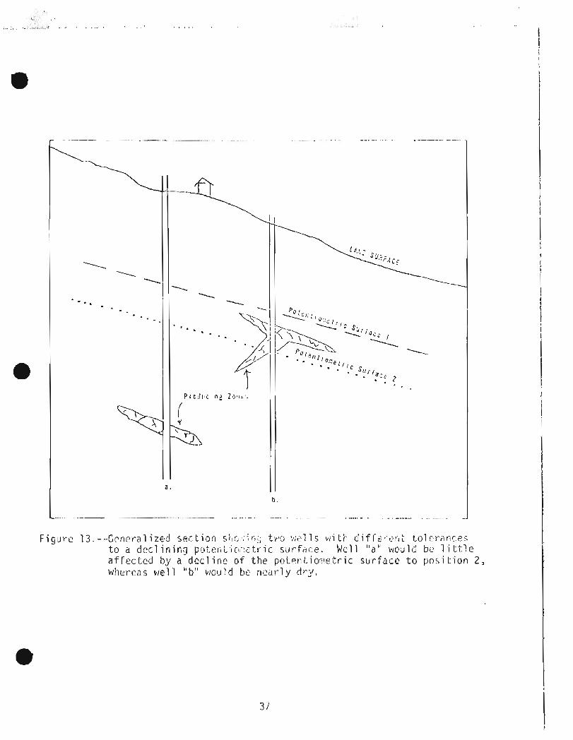
Figur t s 13 . - - ,C~nera l i zec l s e c t i o r l s;~:;., i r - ! ; t v u ltii!lls v i i i i - I di f i ' t : i -c l~. l t t ( . ) l f : : - ; - l r i~~5
t o a decl inin:] p ~ u t e r i t i r ; ~ : , tr-ic sirrfiice. Wcl 1 " a " wr:)~rld be 1 i . t t l e a f f e c t e d by a dcc l irlr o f t h e pc~terl t i o l : ! e t r . i c s u r f a c e t o p o s i t i o n 2, whereas we1 1 " b " w o l ~ l d be? ni:;~rly dr-;/.
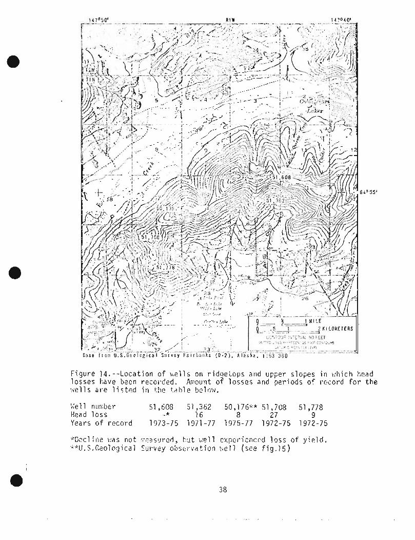
Figure 1 4 . - - L o c a t i o n o f h e l l s on ridgetops and upper s lopes i n vihich head losses have been r e c o r d e d . A;;!ount o f losses and pe r iods o f ri;l:ord f o r t h e l!$ells are l i s t ~ d i n the t z h l e bc low.
;,'el 1 nui;-~bcr 51,608 51,362 50,176+* 51,7C8 51,778 Head l o s s + * 1 6 8 2 7 9 Years o f r e c o r d 1973-75 1971 -77 1975-77 1972-75 1972-75
%eel i i l e was riot :i.;:as:!red, t-!~t i-:pll cxjxr-ienccd loss of y i e l d . .A? .k U. S . Gc:olur:Saal Survey ol?~,crv; i t ion :,,PI 1 (see f i g . 1 5 )


F i g u r e 1 6 . - - ~ C f n e l - a 1 i z e d t;;idi-fiy;?olugic cotidi t i o n s on i i - ~ e 1 or;er s lopes . A s a b s t a n t i a l thi::!,t?;lss o f lo;%:-pet-i,;eiibi 1 i t y s i l t ov:irl i p s w a t e r - - - k - i a r i n t , t ? t -ock . iiel 1 s (:fin s t i l l y i ~ l d sd;:.c;a,~tc k:c l t t . r f o r do~i-,(.!sLic i'ut7j>nsf2s i f t h e ~ ! o t i ? t l t i ~ , , : ~ e t t - i ~ su r face f a l l s several t ens of f e e t .

Thc n e t : water- C O ~ I ~ : . I C ! ~ ? ~ n;c:.y 1;: 5 ~ ; ' - 5 l ? n t i a l l y incrtr!i~:<r!d by w:'ii!r was L t ' . A SC:'pdCJi! p i t kili ~ C \ I i S ric: C rc1.1 :::~d L / ~ ? C [ ~ i.L beco;,;;:~ pl u~';;:cl cdlrscs water' was t c . A ~121 1 irl tilf? a : 'it..ii;~ri 7onc r;l;ici~ i s a1 loi,,c;l t o flo!.~ unchecked a1 s o w a ; t e ~ water-. For cx;li~iple, near t h e i r i t e r s cc t i o r l o f S t f c s e tiighltiay and Farii ier 's L.oop Rnzd ( f i g . I ) , f low con t i nued f o r n i ~ r - c thari a y e a r f ror i~ a wel l i n which a d r i l l in\; coi~lparly v~ar; uriahle t n c o n t r o l ther-hiill e r o s i o n oi" ttlc ~ ~ C ) Z C I I Ler ia l s . Dw-in9 t h e p e r i o d 0 7 ur!cori t r r ) ] I(::! f l o : .~ ( J u l y 1976 to S~ipt i ! : i iber. 1 9 7 / ) , ttlc w i l l disctlhrqed nioi.2 ti it:!^ ? C mi 11 ion ga l of gruirrld w a t e r , and r:a t e r l eve l dcc l ine:: 8.7 f t. i I ) a v,pll 1 oca tcd 764 f t ups1 ope . Uncoti t r o l l ed flow hzs occur red f ror :~ s ~ v c r a l o t h e r we1 1 s a1 ong Farri:er.'s Loop Road and frul-il one i n t h e val l e y o-F Golds trc;tr;i C r e ~ k .
Ground wztei- thr-ol~ghiir-~t t h e u;!la,-!c!i; i s o f calciui!! bicai-bar:t:te o r ca lc iu r~ l s u l f c ~ t e t y p e . Four c i l r x i c c ~ l p r o p e r t i e s o-i coficeun t o t i i o 5 t l o c a l ~ O ~ ! I ? ~ D W T : ~ Y . S a r c I-~arcirie.;s o f wa tor a n d i t s cor~i.cri ' i ra t ior ls O F arsrtrli c , n i t r d t e , and i r o n . Heal t i i--relatzc; as;le;-ts o f th:,_;e prop.::r-tie; a r e d i s c u s s e d , and t h e d i s t r i b u t i o n o-T groi!nil vi? t:clr con t i i i r i i t i 2 o l ) j i : l . t i o ! . ; ~ ! ~ l ~ an:o~.irlts o f each a r e dep ' ic tcd on a n!dp by Joh(;;orl arid otii::irs (appr~dvccl for'
a pub1 i c a t i o r i ) .
Groiirid wa t e r con t a i ti irig a r s cn - i c i n excpss o f the re i .~i~- . , -~~i~i i r l . r l niaxii;; . i 8 , :
f o r d r i n k i n g wa t c r (Enviu.oii;:ieiitdl Prycrtcctinn Agtlricy, 1975) i s spr;c-al.!i.- c a l l y d i s t r i b u t e d t t1rou5i1out ti-12 up1 s:~ii:;. Arscr l ic poiso:) it-12 ti;.; b(--.::;-i r epo r t ed i n Nova S c o t i a iri a r i ; ~ n li:iicl bias drinkiric; v:at~,c- cc,~l!;t~ir,ir!ij 5 rr~z,/L of a r s e n i c (Grantha111 and Jones , 1977 ) . Corlccntraiiorls abcrv? 0 . 3 rriu/L. o f d r i n k i n g wa t e r have been co t - r e l a t ed w i th i nc r ea sed incic lcnces o f soirie forn:s o f c ancc r (Envi rotir,~irri t a l Pro Lcction Agency, 1 9 7 2 ) . Thc n1a;tiniuili arscrl-ic c o n c c n t r a t i ori d ~ t e c t r i l i n rr!ore tt-lzn 300 ~ro:.r,r.rl--w;~te:. sarcplcs froill t h e Fa i rbanks up1 ;:r;d: i s 10 n!cj/L. Arstlrlic i s c o l o r l c r ; ~ , ocicirless , and u n d e t ~ c t a t r l c ill w a t e r except by a p rope r ly eqi.lipped l a h o r a t o r y . I t i s no t reriiovcd by d ~ ~ : i c s t i c wattir- t r c a trrir::~ t sys tcrriis sircti a s ela t ,er s o f t c : ~ c r s o r reverse-osnlosis u n i t s .
N i t ra t (2 coric.~lr~~tr>dtiorI:> i n e x < : e 5 5 07 t i ~ c FP?, rcc(>l:,, ; : : , , : I L , . ! ri;:,:<i~,!l.::;~ f o ~ d r ink ing vic..tct7 at-c a l s o s p o r - a d i c a l l y d i s t r ib( . r tecl t h r ' ~ ~ j ' l ~ i : t ttir: upland,. N i t r a t e i s c o l o r l e s s and o d o r l c s s and i s a h t c l t h h a l a r d p r i i i i a~- i ly t o ir lfari ts under 3 months o f agc . A1 thougi-I a siri-~ple f i e l d t e s t can be mad^ for. ni t r a t c : , a r i a l y s i s by a qu?l i f i c d l ab~ r ' ? t o r -y i s n : c r ? p t . e ( : i s ~ . N i t r a t e , 1 i k;: ar:;ci i ic, i s no-t: re;~;rjv=-d by nlost L:;: b:r--tr~~tr~!(:r i t sys t~,-,i:, .
A1 ti-101.1gii i r o n i n wa te r i s r iot a heal ti1 hazard , i t i s a nu i ssnce t o corisuil ;.r-s and cause s s t a i n i n g of c l o t h i n g and pl uritbirig f ixtc.rrr:s, Much of t i l e ground wa t e r i n t h e u p l a n c ! ~ cur-~tcc,ir~s rrure than 1 nig/L o,f i r o n ; grot.1n3 n a t y r corltairiirlg l e s s t h ; i n 1 n i? /L hcls b[!i.ri d ~ i ~ c t ~ d ovlly i n ssil!--
@ ple; c o l l e c t e d fru!i! w i l l s or) t h i : up>cr slop;; anil r i d g c t o p i . Iron ~ 3 , i l be ri,~:ovccl by i n d i v i d ~ r a l e i ; i t ~ - r . - tr-t 3 trr!i>oL sy5tt>;1ic; i n s t a l 1 eri irl iioi,;:,s.

i i i y h h ~ r i l t i e s s of i,:dterA i s p r i r : ; ~ r \ i l y a nuir;ziicz riil;hcjr -i;ii;ln a Iii:.al t h i d . l l a rd wa Cer conc,!irncs sonp i i r~d r i ; lpu~i t s s ca l e on pl i..i!ibi rig ~ . ~ x ~ u I ' o s , xatctr h e a t e r s , arid cookware. A1 though des-i rnbl e 1 ~ v e l s of t:a\'di.lc:;~ a r e a Ilia t t e r of i nd iv idua l consu~lwr pi-eference, 100 irig/l_ i s st1 dj1pro;~i17a/LC boundary bctwcen what lnany poclpl e cons ide r /-lard and s o f t via t e r (Iiclrn, 1970) . Using i h i s c r i t e r i c j n , s o f t :.;ater has bzsn fci.irid i )n ly i n 1;:clls l o c a t e d on and ri(!l:r t h e rids;-!Lops ?hove ;n e leva- t - ion of 950 f t (Llot~r~:,on 31-1d o t h e r s , approvcd for p1;hl i f l a t i o n ) .
Othcr n u i sdnce character- i s t i c s of ground wate r a r e t a s t e and odor . Those ;Ire atiril:ll.if:-ble t o : ! i~ i , , i . ;o~ i t lg ~ i , g ? n i r , i!;;ltet-ial it1 tlie s~:tlii;;ents <ind <ire ~ s ~ ! , j l l y a(:(:,:,,-.;;;z~~ii!:d hy ;I-111-1 ( :b !~~~: r -~ t r~ : i t i t i r~s i n e:<,t;r!!-,5 o f : ;cvi~ral ;-nilligrarns per l i t e r . T h e c:oii;binai-.ion of t:?d t a s t e , h;rd odor , and r u s t y wate r h a s caused sol:le up1 31-~d ~-IG~:;::O'.;:~(:~'S t o d i s ~ o n t i n u e I J S ~ ! ] ~ t h e i r we1 1s f o r d r i nk ing w a t e r .
The ~ i r iv i ro~i i , , i ' t~ td l f a ~ i o t - s of pt-iticipal i n t e r e s t i n tic?fining pol lu t ic ln s u s c c p t i b i l i t y of t h c upldnds a r e ttie c a p a c i t y of t h e s o i l t o i i l tc r b a c t e r i a and s o r b chi-inical p o l l u t a n t s , and t i l ~ depth t o t h e wa t e r t a b l e .
S i l l ~ t i ~ I;YS~::;IIS ill ti)? ~ j p l L i i ( . i ~ ii1-13 ~ : ~ 1 p l a ~ f 3 d ei t i l e r i n s i 1 t o r b~d roc_k . It:iic:re t h e e f f l g e n t i s cihlc io pcrcolai -E t.hl-ouijh s i l t , ti117 iiiial 1 cjra-in s i z e should pixovido sood I'i 1 i r a t i o n of t ; ac tc r ia . t!i~ui-e tiic pt:~-ir-icabi 1 i t y of t h e s i l t i s t o o low t o p c r ~ i ~ i t t he ( ~ f f l u ( ? t i t t o p ~ i r c o l a t e do+;:iward, ir~uch o r a1 1 tile e - f f l [ lent r>ioves t.o tile Iznd s u r f a c e ?,ili?r-e i t e i t h e r runs o f f o r i s l o s t by r:vapoti-zilspir-at ioli. !:i-!;?t!-ier i t i n f i 1 ti-3ti.s or- .floi?rs t o t h e s u r f d c e , ti-ie t l l r c a t o f !;r:cti?\-ial icjnl: ,?ininati<~n t o tile ci:jni f e r i s s l i g i i t . l-:oiL;ever, i, , .?ai th 11az;ir.iis :;.ay ~ J E posf'd by c;'.fl~ir.:i,~l: tiiat I=;:;~I:~-I:?S ;:he 1 a n d s u ~ + i a c e . S e p t i c sy.;:;?:,.!s p ? a c e d - in b2drock iiay ij i <c.ii;l-.~e e f f l u ~ n t t o a v a r i e t y o f i : i a i e r i a l s . I f tthc b>dv.i?ck i s deco!;;;~osr+d irlicn s c h i s t , t h e f i l t r a t i o n 2 n d s o r p t i v c i capac i t i es li,ay provide ?nod .Ir(2atii.ierlt: of e f f l u e n t . I f t h e t i ' : d1 '~7~k i s -fr+ac_tu~-cd b r i t ' i l c r ock , s9.h as quar tz- i t e nt;d i ; -~arble , t i le j o i n t s 3: id - r r + ~ i t l ; r - ~ s :;;?y S C ~ ~ I C a s hI:r:n i.or~ciaits iqiiictl pr-ovide neyl i g i b l e f i l t r a t i o n .
Most of the sccpacje systciiis i n t h e ilplands d ischarge e f f l u e n t niany t e n s o f f c c t ahovc t h e \!air.ir t a b l e . E f f l u e n t per-r.olates tlob:~-~wdrd through a v a r i e t y of rocks and III~I-tsr-a1 s ;_ind i s ai:t3ati3d over a s i g i ~ i f i c a n t di:;tance. I I! ;,ii::~-e the si:F\J;ige p i t i s (:l-i;~lsi-:::d i n I - O C ~ S vi'i . t t~ poor- f i l +;! .at ion and scr-pt ive c!;ar-?ct,t?ris-ttics, ti-:? ef f l i i z i l t i'iay 1-lave t o c . ; ? ( ~ I I -Liircjl~gh f i n e r 2nd ~.-~ou.e r e a c t i v e r l l a t ~ r i a1 a t dkp'ih :hefore i t reazi-IPS Lire sa tu ra ted zone. Ac ra t i on a1 s o I-121 ps t o o x i d i z ~ b a c t e r i a and soinc vt.hcr pol 1 u l a n t s .
Thc pl)t::ntia1 f o r fjsc!:.:_~-ial ;.lo1 lu i i 'o r l o f the I,$(.jr.ock aqi.rifer i s r , i i \ ' ~ ; i ; ~ ~ t i 1-1 a ~ - ~ ? d s l a c k i tig s i 1 t to f i l t;:r* li-ic ~I ' l ' l i l en t ~ n d \ , i i ~ ~ - e -i,he \*;?Let- tab1 e js c l o s e t o t i i c 1 r.r:d stll--;ace. Srrch ~;or-ldi t i c n s a r e u ~ i l i kc ly t o be found sou th of Goldstrezin C I - P C ~ because tile s i l t cover t h e r e i s

t h i c k on t h e rriiddle a n d lev:" s l o p ~ 5 . tlo:.:?ver, the s i l t c o v ~ r th ins nor-tti:aic.rd, a n d , n o r t h o f Go1 ds t r - ~ , ~ . ~ Crcci;, t t , ? pr-ob;:bi 1 i i y o f f i n i ! i n g such c o n d i t i o r ~ s increases.
As of t h e s p r i n g o f 1978, t h c r e w r - e no kncrwn i n s t d r i c ~ s o f b t i c t ~ r i a l c o n t a m i n a t i o n i n t hc rndrly h u r ~ d r c d s o f w p l l s corr ipleted i n the berlr-ock a q u i f e r . The a r ea t i l e r e f o r e ap;;-zr-s t o h ? v c a lob; p o t ' c r ~ ; i ~ l f c r r cori tarn ina- t i o n .
Anclcrson, G . 5. , 1970, l lydroloyic r ~ - l c o l ~ n a i s s a r ~ c e of ihc T ~ ! , a i l a t,4s i n , c e n t r a l Aldska: U.S. Goo1 . Slrr-vey Hydr-01 . I n v . A t l a s HA--319.
Ikrnes, D . F . , 1961, Grav i t y low a t I4inio F l a t s , A l a s k a , Art. 383 i n Geo1ogic:al Su17vcy R~s(-(~r-c:h 1961 : I J . S . Geol , C ; I I I ' ~ I I : Y P r o f . P,?p(fr 424-D , p . ~254-r1257.
Ctidergren, H . R . , 1967, S c ~ p a g c , d r a i n a g e , i:nd f low r:cts: r.!ew York, ,John Wilcy arid Sons, !a3 p .
C~der-s t rorn, D . J . , 1963, Ground -:.:;tter r-cr.oiirccs of itlc Fai 1-13~3nks a r c a , Alaska: U.S. Geol. Survey PJater-Supply Pap?r 1590, 84 p .
Corps of Enginucrs , 1974, C h c n a Lakes P r o j e c t , A1 a s k a , desi y n ii1t:rnnrandurn no. 3 , supplcr:ic.nt no. 1 , I n t e r i o r dr-ai nagc f a c i 1 i t i p s , phase 1 : U . S . Al-iniy Corps o f [Illgineer-s, Alaska DisLr - i c t , 70 p .
Di n?n;an, S. L . , 1971 , liydrol ogy o f the Gl el-~n Crcck v:atclrshed, Tanana River b a s i n , c e n t r a l A1 a 5 k a : U . S . Arrliy Ma te r i e l Coi:i:,~at~d, Cold Ri:gions Rescat-ch and Eng. l ah. R ~ s e a t - z h R ~ p t . ?97, 110 p .
1973, Tt ie \,:aLcr balrlni:e -ill n r c i i c , j i -~d s \ ; ! . , ~ r c t i c I -cyions - r , r~nota ted 11 ib l i o r j i -aphy ; . . I - I~ pt-el i:liir;ury asses:!. ::r-~t: U . S . At-iny Ma te r i e l Con~mand Cold Regions 2 r : se~r ih srld Kng. Lab. Spcc. Rept . 1 8 7 , 131 p .
t:nvii~oriiiic?ntal Pindt.ection Asc:i?cy, 1 9 1 2 , A rel:jor-t of l i - ~ c C.ci,;:i~ittee on i,!ater Qua1 i t y C t - i ti:ria , Zt'~v' l i-c;r ; , : \c~\tal St l~d ic?s B[:?\-d, r43tional r , ic,c .. - d tlliy -, ., o f Sc ic:nc:cs, ',:;i 'iior:al A~;l:il?~il~ of E r ~ g i i ~ c ~ r * ~ : !~!;:shirigtcn, U . S . G u v t . P r i n t i n g O f f i c e , 594 p . [I9731
Elivironment,al Proti2ction A ~ f r i c y , 1915, Nat ional .interill1 pr-ii~iary d r i l ik i ng ~ i i t ~ i - r ~ ~ g ! ~ l a t i c i r i ~ : 1-cdzral R~yister, v . 4 0 , no. 248 I,Jil.dl-;tisday, I)ci:~r:-~kicr 24, 1975, P a r t I V Y p. 59256-53587.
Feu lne r , A . J . , 1961, Geology a n d :.iater c o n d i t i o n s a t Ladd Ai r Farce Base, Alaska: U.S. k o l . Survey I 'ydrol. D a t a Rept. 13, 17 p .
r r a n k s , A . I . . , 1 9 1 2 , G ~ o l ogy f o r i nd iv idua l seia?aye cliisposal systelns: C a l i f . Gcoloyy, v . 2 5 , no. 9, p. 195-203.
Gordon, R . C . , 1973, Kintcr s u r v i v a l of f e c a l i l l d i c a t o r bact-cria i n a s u b a r c t i c A1 a s k a n r i v c r : E n v i I-onlnantal P ro t cc t i o n Agency, Environnikntal P r o t e c t i o n T c ~ h . Rept. E P A - R 2 - 7 2 - 0 1 3 , 41 p .

0 Grantham, D . A . , and Jones J . F . , 1 9 / / , Arsen ic contarninat ion of water
w e l l s i n Nova S c o t i a : Journa l o f t h c American Water Works A s s o c i a t i o n , v . 69 , n o . 1 2 , p . 653-657.
He~ii, J . D . , 1970, Study and i n t e r3p r? t a t i o r i of t h c chcmical charac te r . - i s t i cs o f n a t u r a l water: U.S . Geol . Survey Watcr--Supply Paper 1473 ( 2 d e d . ) , 363 p .
Johnson, P . R . , Wi l c o x , D . E . , Mory; :~~, W,D. , Merto, J o s t > p i ~ i r ~ u , ar:d McFadden, Ruth, 1978, Ar sen i c , n i trd t ~ , i r on and hardness i n ground w a t e r , Fa i rbanks a r e d , Alaska : U.S. Gcol. Survey o p e n - f i l e r e p o r t (map) 78- 1034, 2 s i ~ e c t s (approved fo r pub1 i c a t i o n )
Kiny, P . B. , compi l e r , 1969, Tcctorlic map o f North America: U.S. Geol . Survt>y niap, ( s c a l e 1 :5,OCio,OOi1) 2 s h e c t s .
Loi:il,c.il, S . W . , 1972, Grourid-wa t ~ r hydraul i c s : U . 5 . Geol . Survey P ro f . Paper 708, 70 p .
F ' , e inz~_r , 0 . E , , 1 9 2 0 , Qu?.riti t a i i v t ? rrjc:thc,ds of cs t:im;iting gr-~: .~t-~i l - :.:?t;fr suppl i e s : Gcol . Soc. A::i:r-ica t : ~ r l l . , v . 31 , p . 329--33:':.
M ~ r t i e , J . B . , 1937, The Yukon-Tanana r e g i o n , Alaska : U . S . Gcol , Survey B u l l . 872, 276 p .
Nat ional 0cr:anic and Atri~:,-,pher-ic Adi-;ii n i s - t r a t i o n , 1967-1977, Local Cl inia t o l o g i c a l Oa t a - Annual Su;i\iii~ry w i t h Corlipar-ative D P ~ t .3 ,
vol s . 53-63, Anchorage, A1 a s k a Envi ronii~er-I t a l D a t a S e r v i c e , Nat ional C l i m a t i c Ccn t e r , A s h e v i l l e , N . C . ,
, #
Pew?, T .L , , and B e l l , J.W., 1 9 7 4 , Map shoi.!i'ncj d i s t r i b u t i o r ~ o f pet- frost i n the F a i r b a n k s 0- 2 SbI q1la~clr'ar?.;l1c, U . S . Gcnl . Survcy Misc. I n v . niap I-829-E.
- 1975a, Map showi t\g ground-water c o n d i t i o n s i n the F a i r b a n k s D-2 SW quad rang l e , Alaska : U.S. Gcol. Swrvey Misc. Inv. Mdp
1-829-C (1976 ) .
1975b, fvl;lp s i iow i r i y cons tr-uctiori n~c l te r ib l s i n t h e Fa irli6r:C:5 0 - 2 -- - . - .-
SW quadrdnglo , A l a s k a : U.S. Geol. Survey Misc. Inv. Map I-829-D (1976 ) .
-. 1 3 / 5 c , Map showing f o ~ ~ r ; d a t i n n condi tior;s i n t h e F a i r b a n k ; D - 2 SCI q u ~ ~ d r - a n g l e , A1 a ska : U . S . G ~ o l . Survey M i s c . I n v . Map I-57'9-E ( 1 9 1 6 ) .
, >
[)~,,:p, T . L . , 611d Re11 , , ] . I d . 1 ? / 5 d , Ihp p,trowing dis t r i h ! ~ l i o n of i>i.)-;:'af~ o s t i n t h e Faii7Lit:ks 0-2 !;1d rjuadrhngle, A laska : U.S. C ~ o l . Sur.vr?y I'iisc. F i e l d S t u d i e s isi~l-, fll' 668--A (1916) .
- . - 1375e, I-:ap si lovr i 1.19 gro~il-ld ;c:ater-cnr~di t i o n s i n - l i ie F a i I bilt?%s 0-2 P4W qc:adrnngle, A l a s k a : IJ.5. Gc-01 . Survey I 4 i s c . F i ~ l d S t u d i ~ s ;:ap I';F-668-B (1 976) .
. - 1975f , !:;ip si-ii::)ri rig cc,nsti-ur;tinn indtfirial s i n ti-IE Tairbanks 0-2 N W qi:;lr:r.?r~cjle, A1 a s k a : U.S. Czol . S u r v e y t4isc. F i c l d S t u d i e s 1 % ~ i :F--6GZ-C ( 1 9/6).
.. . -- - . 197!5rj, b;ap r;i~o\~it-lg frjuntlation COI-iditic;r-is in the Fait-banks D-2 t\lW qi ic~drar~gl e , A1 li.;ka: U . S. Geol . Sul-vey l 4 i s c . F i e l d S t u d i e s Itlap i*:F--668-D (1 976)
1975h7 :-lap siio+iing d i r i r - i h u t i o n of ~ ; e r ; : ~ a f r o s t i n tiict Fair-banks D-2 ?
SF: quaril-angle, A1 a s k a : U,S . Geol . 5ur7vcy Ilisc. F i e l d Stirdies r4ap MF-669-A (1 9 7 6 ) .
- 1975i , Map silowi~ig groutid-water c o n d i t i o n s i n the Fa i rbanks D - 2 SE quadrungle , Alaska: U.S. G(!ol. Survey M i s c . F i e l d S t u d i e s Map 14F-669- B (1 976 ) .
. . . - - .. - 1 9 7 S j , I?zp s t i o w i ~ ~ g corlst i7ucti t?n l i ~ ? t c r i a l s i n t h c Fairb;nks 0-2 SE q i ~ a d r a ~ l g l e , Alaska: U.S . Eeol . S u r v e y M i s c . F i e l d S t u d i e s Xap MF-659-C (1976 ) .
. ... . - -- 13 /5k , : .hp siir.)kji r-ig lolr111.la t i o n cc~-i(j.i t-ic;r:s i n t i i c F a i I-':;r:nks 0-2 .C;E r ,~1~ic ! t - j1 -~g l~ , A1 asI :a: U.S. G%o1, SU~"JC-Y ; i i s c . Fir-.ld S t u d i e s f*:ap i t , F . - ~ ( j S - . ~ (1 976) .
19751 , !,lap ~ h ~ i j i l i g ( I i ~ t r - i b u t ion o f pi7ri8,afrost i n the Fa i rbanks D-2 - - -
N E r ; u 3 d r z ~ g l e , Alaska: 1J.S. Szo l . Survey :disc. F i e l d S t u d i e s Fap MF-67C-A (1 976 ) .
1975rn, F'iap jl~ov!ing gr-r?li~d-i2:ater c o n d i t i o n s i n i h e Fairbanks D-2 -
NE quodranyle , Alaska: U + S . Geol. Survey Misc. F i e l d S t u d i e s Map MF-610-B (1976) .
. .. - - . 197511, Z d p si-1ci.ri11g i r o r , i s t r ~ ~ c t i o n n:a tcr ia ls i n t i i u Fairbanks D - 2 NE qi~a(lr- .angle, A1 a s k a : U S . Geol . S u r v e y I l i sc . Field S t l ~ d i e s Map MF-67C-C (1 9 7 6 ) .
19750, iblap shc:.iing fobntlation c o n d i t i o n s i n t h e Fa i rbanks 5-2 N E qua(:t*anyle, Alaska: U.S. Geol . Sal-vey Misc. F i e l d S t u d i e s Map b1F-670-D (1 976) .
~ 6 ~ 6 , T.L . , and B e l l , J.W. , 1975p, Map showing p c r n ~ a f r o s t c o n d i t i o n s i n The Fairbanks D-1 SW quad rang l e , Alaska: U.S . Geol. Survey M i s c . Fie ld S t u d i e s M?p MF-671-A ( 1976 ) .
-- -. 1975q, Map shovri ncj ground-water c o n d i t i o n s i n t h e F a i rbariks 0-1 5I.l quadrdngle , Alaska: U.S. Geol . Sc~rvey Misc. F i e ld S t u d i e s Map MF-671 - B (1 9 7 6 ) .
- 1975r, Map showint c o n s t r u c t i o n mater-ials i n t h ~ F a i rbank; D - 1 S\.l q u + d r a n q l e , A1 aska : U.S. Geol . S u r v e y Misc. F i e l d S t u d i e s Map Mi-571 - C ( 1 976)
1975s, Map shoviiriy four idat ion corldi t i o n s i n the Fa i rbanks D-1 SW -- -.
quad rang l e , Alaska: U.S . Geol . Survey Misc, F i e l d S i ~ r d i e s Map MF-67 I -D (I 976).
P & I ~ , T . L . , B e l l , J.W., Foriies, R . B . , a n d bicker, F .R. , 1975, Geologic map o f t h e Fairbarlks 0-2 N141 q u a d r a n g l e , A l a s k a : U.5, G~r31. Survily M i s c . Inv . Map I - 9 0 / .
1976ii, Geologic rnzp o f tli? F a i r i ! ~ ~ n k s 0--2 S'd qu?t l rar is l r , A' laska: U .S . G f o l . Survoy b l i s c , I n v . F.l?p I-S?9-A.
• . . 1976b, Geologic ma? o f t he Fa i rbanks D-2 SF: quadrangle , Alaska: U.S. Geol, Survey Misc, I n v . MCp 1-94?.
-. -. .- - 1 9 7 6 ~ , Geulog i c nizp o f t h e Fai rbanks D--2 NE qa,:drc:rijle, Alsska : U.S. G ~ o l . Survcy Misc, Inv. Map 1-959.
, >
I P e w , T . L , , B e l l , J .W., Williai.15, J . R . , and P a i y c , R .A . , 1976, I
I G ~ n l o g i c rnap O F t h e Fairbaiiks I)-1 SPI quadrancjlc, Alaska: U.S. Geol . Survey Misc. I n v . ML;) I-9?9.
Riege r , Saniuel , I)cri!v?nt, J . A . , a n d San~jsr; , Dui-~r~ee, 1963, Sni 1 survey I o f Fai rbanks a r e d , Alaska: U.S. Dept . o f A g r i c . , So i l Cons. I S e r v i c e , S e r i e s 1959, no. 75 , 41 p . , 25 p l a t e s .
S c h n ~ i d e r , W.J., 1970, Hydrologic ir;1[11 i c a t i on i ; o f so l id-j~?' ; t i : t d i s p o s a l : U.S. Geol . Survcy C i r c . 610-F , p . F I - F 1 0 ( r t ?pr i r i bed 1972-.1973).
S t a t e o f Alaska, 1973, T i t l e 18 , E n v i r o n ~ : : ~ o t a l Conse rvz t i ons , Chzp. 72 \la.; tevia ter D i spirsal .
T h f i s , C . V . , 1940 , The sourcp o f v ~ ? t , - . r - der.ived frorn we l l s - F s s c r ~ t i a l fact(;,!-s con t ro l 1 ir;y t h e respqr-~sc o f an a q u i f e r t o d ~ ' ~ e l o ~ , i ? i ~ i l t : C i v i l Fng. , v . 10 , no . 5 , p . 277-220.
0 U . S . Puhl i c Hen1 ti1 Scr-vice, 1962, Dririkir.19 w a t c r s tand i r -ds : Pub1 i c
H ~ o l t h S c r v i i e P u b . 956 , 61 p.