Embed Size (px)
Citation preview
FIG XXIII CONGRESS 8-13 October 2006 Munich, Germany
NATIONAL REPORT OF HUNGARY
2002-2006
www.fig.hu
MAGYAR FÖLDMÉRÉSI, TÉRKÉPÉSZETI és TÁVÉRZÉKELÉSI TÁRSASÁG HUNGARIAN SOCIETY of SURVEYING, MAPPING and REMOTE SENSING UNGARISCHE GESELLSCHAFT für VERMESSUNGSWESEN, KARTOGRAPHIE und FERNERKUNDUNG SOCIÉTÉ HONGROISE de GÉODÉSIE, CARTOGRAPHIE et TÉLÉDETECTION
2 Hungarian Society of Surveying, Mapping and Remote Sensing
National Report 2002 - 2006
FIG XXIII Congress 2006, Munich
Contents
1. Introduction _________________________________________________________ 3
2. Hungarian Society of Surveying, Mapping and Remote Sensing (MFTTT)_________ 3
3. A Periodical for Professionals: “Geodesy and Cartography” __________________ 7
4. Professional Standards, Regulations and Practice ___________________________ 8
5. Education, Training and Knowledge Transfer_______________________________ 9
6. Spatial Data Infrastructure and Land Information Systems ___________________ 11
7. Positioning and Engineering Surveys ____________________________________ 14
8. Cadastre and Land Management Issues __________________________________ 17
9. Spatial Planning and Development ______________________________________ 20
10. Quality Management Issues ____________________________________________ 21
11. Conferences, workshops _______________________________________________ 22
3 Hungarian Society of Surveying, Mapping and Remote Sensing National Report 2002 - 2006
FIG XXIII Congress 2006, Munich
NATIONAL REPORT OF HUNGARY 2002-2006
1. Introduction Hungary has been a member of FIG for decades, and the Hungarian National Committee (HNC) has been represented in all the nine, and now the ten commissions. The Hungarian delegates have been always playing an active role in the organisation. In Hungary and in several neighbouring countries, the slogan of this congress “Shaping the Change” can be interpreted more generally, because it concerns not only land surveying, but the whole social environment. In the recent period of the Hungarian land surveying, the current political and economic changes claim fast and well-prepared action from every member of our profession. This is necessary to keep track with the international trends of our profession and also follow the changes in our society and economy. This is a great challenge also for the Hungarian Society of Surveying, Mapping and Remote Sensing, being the only professional-social organisation of the Hungarian land surveyors. The Society has to support its members in this new situation, in the age of new and unknown tasks (such as privatisation, compensation or establishing the new bases for the registration of land and property data.) At the same time, we have to continue the activities coming from our FIG membership, thus our experts should stand the demands of a changing age. The Hungarian Society of Surveying, Mapping and Remote Sensing tries to give help to its members in solving the tasks, and organises the work of the national departments in accordance with the FIG technical commissions by enforcing these trends. Hungary has always been playing an active role in the organisation. Especially the Hungarian members of the Commissions 2, 3 and 7 have been very active. The Hungarian delegation worked very efficiently on FIG’s Regional Conference, Marrakech, 2003 as well as on FIG Working Week in Athens, 2004. The Hungarian representatives, Mr. Béla Márkus of Commission 2, and Mr. András Osskó of Commission 7 are voted as chairs of their Commissions for 2006-2010.
2. Hungarian Society of Surveying, Mapping and Remote Sensing (MFTTT) In 1867, when the Hungarian Association of Engineers and Architects, the first professional organisation in technological field was set up, the Hungarian land surveyors were present too; they founded the Section of Land Surveying, while the cartographers have been active within the Hungarian Association of Geographers from its foundation in 1872. As a result of the development of land surveying technologies, the Hungarian Society of Photogrammetry was organised in 1929. Unfortunately, after the Second World War, the activity of these
4 Hungarian Society of Surveying, Mapping and Remote Sensing
National Report 2002 - 2006
FIG XXIII Congress 2006, Munich
associations stopped under compulsion. Only the social movements directly prior to the revolution of 1956 made it possible to found the Society of Geodesy and Cartography on 20th April, following its professional organisations-predecessors. Similarly, reflecting the contemporary social movements in 1990, at the General Assembly of the Society, the members – answering to a spontaneous initiative – decided to change the name of the Society to the present one. In 1998, the Society became a Public Benefit Company. So, in 2006, we are celebrating the 50th anniversary of the foundation of our Society. The Society, being a Public Benefit Company, is a member of the Federation of Technical Scientific Societies (MTESZ). The Society’s services of public benefit and others are publicly accessible according to the terms written in the half-year programme, the invitations to events, open tenders and advertisements. The Society brings together all those professionals (public servants, state and other employees, entrepreneurs, pensioners, pupils and students) of the land surveying and land administration (registration, use, protection and classification of land), cartography, photogrammetry and remote sensing plus the related disciplines, who wish to act for the aims of this Society within its framework. The main aims and missions of the Society: to help the development of science and disciplines mentioned above, support technological progress, raise the technological level, distribute the professional knowledge, organize and coordinate the professional and social activities of the members, promote their cooperation in professional, scientific and public life, formulate, represent and enforce professional interests, elaborate and propagate the principles of the professional Code of Ethics, keep the traditions of professional history alive, maintain and strengthen the international relations and publicise/promote our profession. To realise all those aims, the Society recommends and has been maintaining cooperation with the organisations of public administration, enterprises, educational institutions of medium and high levels of the related professional fields, the Chamber of Engineers and other civil organisations. The Society also makes proposals for issuing regulations concerning the land administration sector, prepares expertises on the draft regulations by request and represents the expectations of the Society members. It holds biannual itinerary congresses, organises presentations, meetings, conferences, exhibitions, study tours within and outside the country. Main bodies of the Society: General Assembly Presidency Executive Committee Supervisory Board Professional Sections
5 Hungarian Society of Surveying, Mapping and Remote Sensing National Report 2002 - 2006
FIG XXIII Congress 2006, Munich
Presidency: Géza Apagyi President István Klinghammer Vice-President Ferenc Bartos Secretary-General
Dr. Mihály Ágfalvi Deputy Secretary-General Zoltán Uzsoki Deputy Secretary-General
Executive Committee:
Gyula Biró Dr. Miklós Gross Dr. Csaba Máthay Dr. Szabolcs Mihály Gábor Ponicsán Gyula Szabó
The Society is establishing and maintaining relations with foreign scientific and other professional-social organisations, with special attention to the home and foreign scientific achievements, their propagation and utilisation. The Society has been taking part in the work of the following organisations as member: FIG (International Federation of Surveyors), ISPRS (International Society of Photogrammetry and Remote Sensing) and ICA (International Cartographic Association). MFTTT represented by a National Committee in these Organisations. FIG Hungarian National Committee (HNC)
Prof. Dr. Béla Márkus President College of Geoinformatics, University of West Hungary Pirosalma u. 1-3. H-8000 Székesfehérvár, HUNGARY Tel. (+ 36) 22 516 523 Fax (+ 36) 22 516 521 E-mail: [email protected]
Piroska Zalaba Secretary
Delegates Gábor Ponicsán Commission 1 Dr. Rudolf Ottófi Commission 2 Dr. Szabolcs Mihály Commission 3 György Jakus Commission 4 Dr. György Busics Commission 5 Bence Takács Commission 6 András Osskó Commission 7 Dr. Eszter Hőna Commission 8 Dr. Zoltán Forgács Commission 9 Gyula Bíró Commission 10
6 Hungarian Society of Surveying, Mapping and Remote Sensing
National Report 2002 - 2006
FIG XXIII Congress 2006, Munich
All natural and legal persons and any other organisation, which has no legal personality can be member of the Society, as long as they accept the content of its constitution and are ready to act in its interests. A title of distinction is the eternal membership for a Hungarian natural person for his/her activity, based on the decision by the General Assembly. The Society yearly awards to people the commemorial medal „Lázár deák“ in recognition of eminent professional achievement or activity for the Society. A foreign natural person can be a honorary member of the Society, whose merits in deepening the Hungarian relations during the international cooperation are appreciated and if the General Assembly accepted him/her as one of the honorary members of the Society. The members of the Society can also join its regional organisations. The regional organisations of the Society are functioning in counties and towns, and they can be set up at any state, social or economic institution, where at least 10 Society members express a wish like this. Beyond the regional organisations, the Society is operating in the following Professional Sections:
o Surveying and Spatial Planning, o Photogrammetry and Remote Sensing, o Land Administration, o Surveying (legal) Experts, o Geodesy, o Cartography, o Engineering Geodesy, o Topography, o Regional Development and Environmental Protection, o Education and Youth, o History of Profession, o „Tóth Ágoston“ Seniors’ Club o Geoinformation.
7 Hungarian Society of Surveying, Mapping and Remote Sensing National Report 2002 - 2006
FIG XXIII Congress 2006, Munich
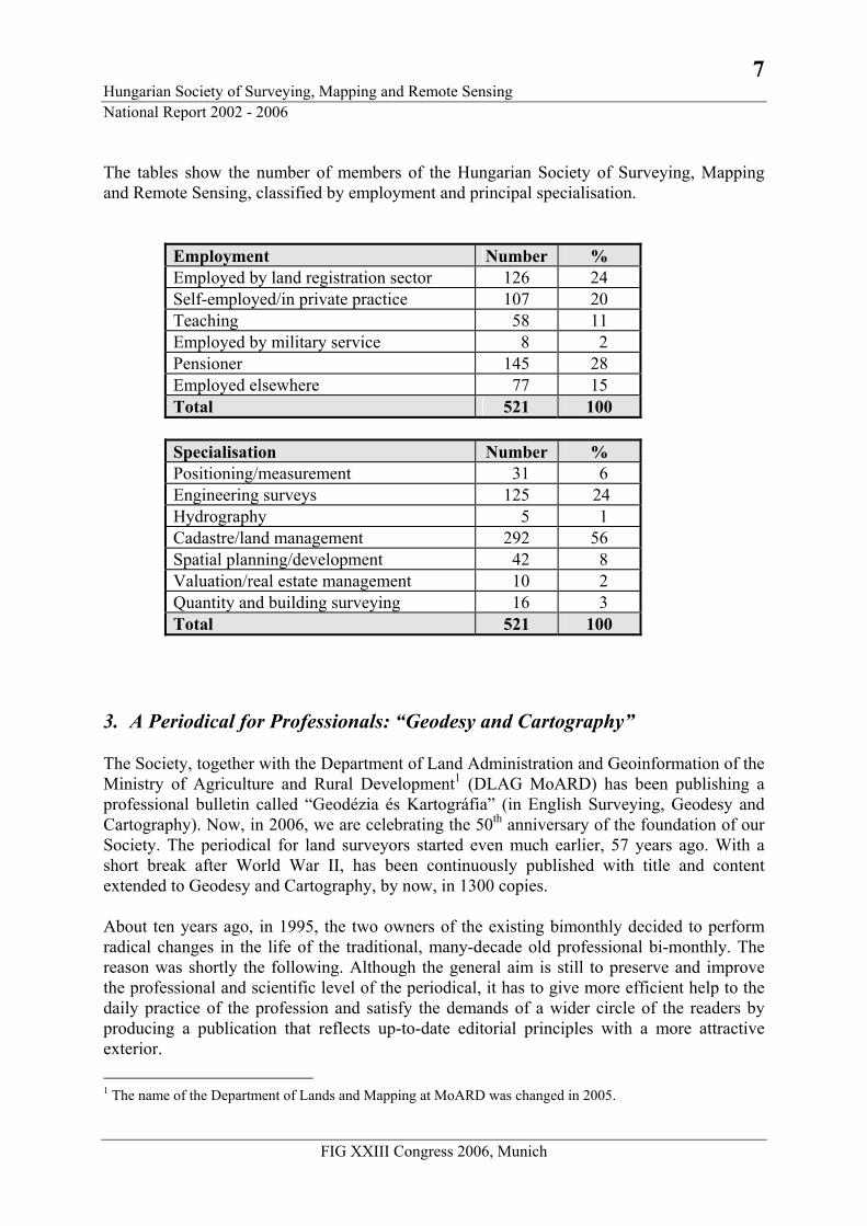
The tables show the number of members of the Hungarian Society of Surveying, Mapping and Remote Sensing, classified by employment and principal specialisation.
Employment Number % Employed by land registration sector 126 24 Self-employed/in private practice 107 20 Teaching 58 11 Employed by military service 8 2 Pensioner 145 28 Employed elsewhere 77 15 Total 521 100
Specialisation Number % Positioning/measurement 31 6 Engineering surveys 125 24 Hydrography 5 1 Cadastre/land management 292 56 Spatial planning/development 42 8 Valuation/real estate management 10 2 Quantity and building surveying 16 3 Total 521 100
3. A Periodical for Professionals: “Geodesy and Cartography” The Society, together with the Department of Land Administration and Geoinformation of the Ministry of Agriculture and Rural Development1 (DLAG MoARD) has been publishing a professional bulletin called “Geodézia és Kartográfia” (in English Surveying, Geodesy and Cartography). Now, in 2006, we are celebrating the 50th anniversary of the foundation of our Society. The periodical for land surveyors started even much earlier, 57 years ago. With a short break after World War II, has been continuously published with title and content extended to Geodesy and Cartography, by now, in 1300 copies. About ten years ago, in 1995, the two owners of the existing bimonthly decided to perform radical changes in the life of the traditional, many-decade old professional bi-monthly. The reason was shortly the following. Although the general aim is still to preserve and improve the professional and scientific level of the periodical, it has to give more efficient help to the daily practice of the profession and satisfy the demands of a wider circle of the readers by producing a publication that reflects up-to-date editorial principles with a more attractive exterior. 1 The name of the Department of Lands and Mapping at MoARD was changed in 2005.
8 Hungarian Society of Surveying, Mapping and Remote Sensing
National Report 2002 - 2006
FIG XXIII Congress 2006, Munich
Preserving and improving the level, publishing the periodical every month instead of every second month, maintaining the “up-to-dateness” was and is still a great challenge. Papers submitted for publication are strictly selected, and professionals are checking the contents of the main articles. Now, looking back at these ten years, our specialised monthly and the work of the contributors can be considered successful. The ever growing circle of authors justifies the existence of the periodical. To writing, one needs first of all something to tell, but it is worth publishing only, when you have a receptive readership and there is a need for specialised literature of high quality.
4. Professional Standards, Regulations and Practice An important task of the special field of land administration is the regulation of land surveying, land administration and mapping on legal level. The regulations, laws affect the following professional fields: the computerisation of land registration needed an appropriate legal background; the preparation of digital surveying base map. The related changes of legal rules enable the land offices to handle both legal and digital cadastral map data of the land registration by computer. There have been a number of changes in legislation relating to land issues over the past few years in Hungary, which provided a framework for the land privatisation, supported the computerisation of land records and the adoption of digital technology. Besides the Act on Surveying and Mapping and the amendment decree to it, the following laws on land affairs are noteworthy:
o Act CXLI (1997) on Real Estate Registration. o Act XLVIII. (1999) amending Act LV. (1994) on Agricultural Lands. This act
stipulates for the registration of users of land of over 1 ha holdings in the land offices. o Act CXVI (2001) on the National Land Fund. The aims of the law include the rational
management of state-owned lands, improved land tenure and land use conditions, as well as support for the development of viable family farms and for those whose living is based on farming.
o Directive No. 1/1998. (FVM. É. 19.) FVM. Subject: On co-operation of institutions participating in the National Cadastral Programme (MARD)
o Government Decree No. 184/1999 (XII.13.) on the detailed rules of Land Office registration of land users using land holdings of over 1 ha.
o Decree No.105/1999. (XII.22.) FVM. (MARD) on the detailed rules of land classification.
o Decree No. 109/1999. (XII.29.) Enacting clause of Act CXLI. (1997) on Real Estate Registration, MARD.
o Government Decree 17/2002.(II.18.) Korm.: Detailed rules of property registration, property handling and utilization of National Land Funds.
o Decree No.41/2002. (V.14.) FVM (MARD) on the administration service fee for supplying certain land registration data available through query from computerised database and on data supply through data transfer network.
9 Hungarian Society of Surveying, Mapping and Remote Sensing National Report 2002 - 2006
FIG XXIII Congress 2006, Munich
o Decree No.98/2002. (X.17.) FVM (MARD): Modification of Decree 21/1995. (VI.29.) FM on creation and handling of digital base geodata.
o Decree 33/2002.(XII.17.) GKM. Modification of Decree 6/2001. (III.19.) GM on measuring the instruments and their metrological supervision.
The introduction of digital technology for the management of cadastral map requires standards. Appropriate standards and instructions are created in Hungary for the definition of map content, their acceptance and quality control, and the digital exchange of this information, mostly harmonised with the respective CEN TC 287 and ISO TC 211 GIS standards. Issued standards and regulations are the following:
o National Standard MSZ 7772-1:1997 on Digital Base Map, Conceptual Model (often referred as DAT standard) has been prepared by FÖMI and issued by the GIS Standardisation Committee (MB818) of the Hungarian Body of Standards and with support of MARD/DLM. This standardises the digital cadastral maps.
o National standard MSZ 7771:1997 Hungarian Data Exchange Format for GIS has been issued by Hungarian Body of Standards based on the respective CEN TC 287 pre-standard.
o Derived from the MSZ 7772-1:1997 standard, a series of technical instructions (often referred as DAT instructions) has been issued by DLM/MARD in 1997. They prescribe the certification and quality acceptance of cadastral maps, as well as the regulation for planning, creating and renewing maps, database content and structure, data exchange format, quality control and certifying of DAT (Digitális AlapTérkép = Digital Base Map).
o National Standard MSZ 7772-2:2002 on Definition of Digital Topographic Database, has been prepared by FÖMI and MS HDF, issued by the GIS Standardisation Committee (MB818) of the Hungarian Body of Standards.
A modified version of the earlier regulation No. F2 on performing certain cadastral survey works using cadastral base maps and related public proceedings, as well as on the institutional background and order of data supply in public land administration has been issued by DLM/MoARD in 2002.
5. Education, Training and Knowledge Transfer The educational need brought about four characteristic levels of education:
o Vocational education o Higher education and o Life-long learning, adult education.
Vocational level in the field of our profession means the public school system. The professional authority is the Department of Land Administration and Geoinformation of the Ministry of Agriculture and Rural Development. With the change of the Hungarian vocational education system in technical secondary schools, the quality of education of surveying and mapping is reached a higher standard.
10 Hungarian Society of Surveying, Mapping and Remote Sensing
National Report 2002 - 2006
FIG XXIII Congress 2006, Munich
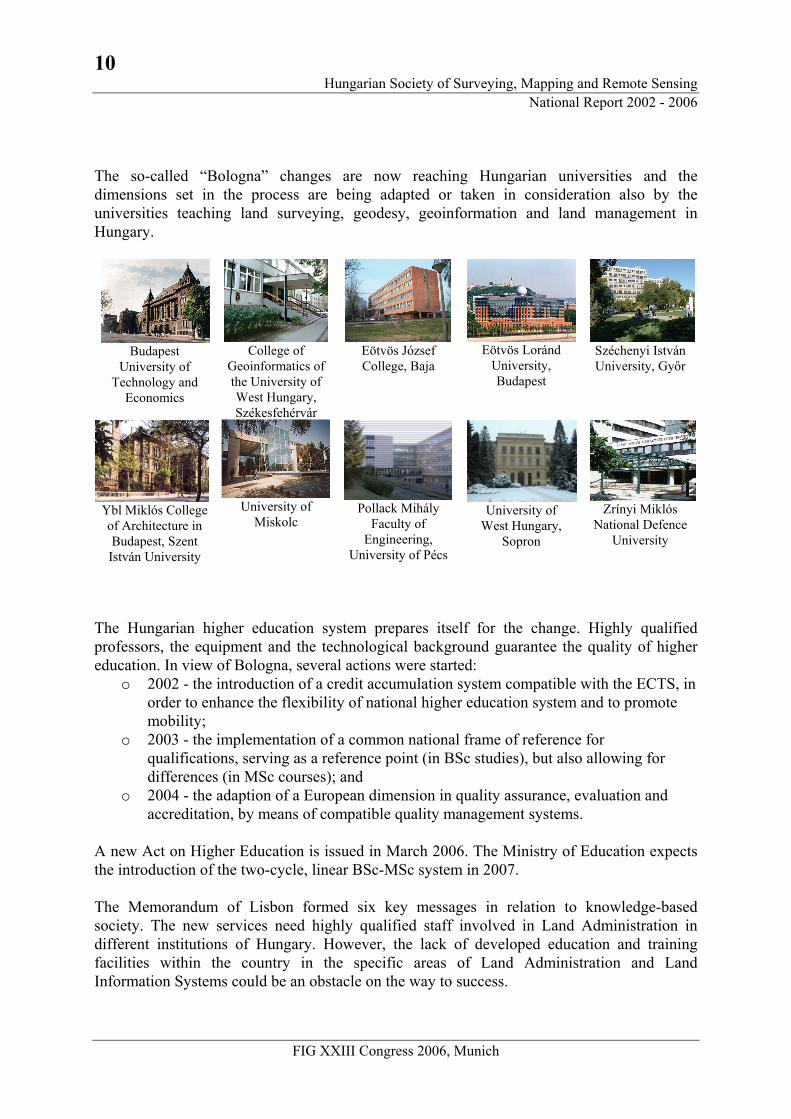
The so-called “Bologna” changes are now reaching Hungarian universities and the dimensions set in the process are being adapted or taken in consideration also by the universities teaching land surveying, geodesy, geoinformation and land management in Hungary.
Budapest
University of Technology and
Economics
College of
Geoinformatics of the University of West Hungary, Székesfehérvár
Eötvös József College, Baja
Eötvös Loránd
University, Budapest
Széchenyi István University, Győr
Ybl Miklós College of Architecture in Budapest, Szent István University
University of
Miskolc
Pollack Mihály
Faculty of Engineering,
University of Pécs
University of West Hungary,
Sopron
Zrínyi Miklós National Defence
University
The Hungarian higher education system prepares itself for the change. Highly qualified professors, the equipment and the technological background guarantee the quality of higher education. In view of Bologna, several actions were started:
o 2002 - the introduction of a credit accumulation system compatible with the ECTS, in order to enhance the flexibility of national higher education system and to promote mobility;
o 2003 - the implementation of a common national frame of reference for qualifications, serving as a reference point (in BSc studies), but also allowing for differences (in MSc courses); and
o 2004 - the adaption of a European dimension in quality assurance, evaluation and accreditation, by means of compatible quality management systems.
A new Act on Higher Education is issued in March 2006. The Ministry of Education expects the introduction of the two-cycle, linear BSc-MSc system in 2007. The Memorandum of Lisbon formed six key messages in relation to knowledge-based society. The new services need highly qualified staff involved in Land Administration in different institutions of Hungary. However, the lack of developed education and training facilities within the country in the specific areas of Land Administration and Land Information Systems could be an obstacle on the way to success.
11 Hungarian Society of Surveying, Mapping and Remote Sensing National Report 2002 - 2006
FIG XXIII Congress 2006, Munich
Life-long learning system is supported by higher education. There are a lot of experts of new educational technology for open and distance learning, there are some good initiatives for e-Learning. Regional distance education centres operate at some higher education institutes that train our professionals. Knowledge Transfer The Central European Land Knowledge Center (CELK Center) was formally established in January 2003 in Budapest, in conformity with a Letter of Agreement between the World Bank and the Government of the Republic of Hungary under the „Property Rights and Land Market Development Project for EU Candidate and Balkan Countries”. The CELK Center's mission was to serve Central, Eastern and South-Eastern European countries as a regional land knowledge management information and advisory center on land market and real property rights related issues. The vision of the Center was to be acknowledged as the primary source for regional information on land market and real property rights related topics: to operate as a knowledge management center on land tenure regimes, land market and land management issues and to provide technical assistance and advice for beneficiary countries concerning relevant policies, strategies, programs and projects. Since its establishment, the Center had fifteen beneficiary countries. The CELK extended the scope of its influence based on request to the Southern Caucasus countries (Georgia, Armenia and Azerbaijan), as well as to Ukraine and Moldova. In September 2005 – as the World Bank Project was completed already earlier and project funds were exhausted –, the moment came when the Ministry of Agriculture and Rural Development declared that they were not in the position to finance the further operation of the Center. The educational and training functions of the CELK Center were transferred to College of Geoinformatics, University of West Hungary, the knowledge base will be maintained partly by the College and the Institute of Geodesy, Cartography and Remote Sensing.
6. Spatial Data Infrastructure and Land Information Systems FIG Commission 3 is dealing with GIS management, within that, among others, with spatial data infrastructure, data models, standards, accessibility of spatial data, legal aspects, institutional structure, and with the question how to manage GIS in a way, which serves the aims of sustainable development. The Hungarian Chairman of the Commission 3 is dr Szabolcs Mihály, General Director of FÖMI (Institute of Geodesy, Cartography and Remote Sensing). Under his leadership, the activities and R+D achievements of the institute are focussed on the creation, maintenance and supplying data of the spatial reference base of GIS, providing basic data for the spatial infrastructure.
12 Hungarian Society of Surveying, Mapping and Remote Sensing
National Report 2002 - 2006
FIG XXIII Congress 2006, Munich
In Hungary, in line with the Act LXXVI/1996 on land surveying and mapping activity and other rules of law, is obligatory to use state land surveying and cartographic basic data (governmental geodata) as a spatial reference for various geoinformation systems. In the world of information technology, it is a basic requirement that these kinds of data should be available in digital form. In the recent years, Hungary has produced significant results in creating framework for the spatial reference systems; the database of horizontal, vertical and 3D (GPS) basic network is ready now (2006). Out of the cartographic bases of spatial reference systems, the following maps are available in digital form:
o Cadastral map, rural area: out of the cadastral maps covering the rural area of 8,5 million hectares, the maps covering 6,5 million hectares are already vectorised. According to plans, vectorising of the missing 2 million hectares is completed by September 2005.
o Cadastral maps, urban area: the digital cadastral survey according to DATA Standard for about 500 000 hectares (6% of the whole territory of Hungary) is completed.
o Topographic map at scale of 1:10 000: o Vectorised dataset of 4089 relief overlays covering the whole territory of
Hungary, o Rastered dataset of overlays containing colour print, relief, hydrography and
planimetry, o Digital Relief Model of 5mx5m grids for the whole country.
o Topographic base map at scale of 1:100 000 for all 84 sheets covering whole Hungary,
both rastered and vectored, o Satellite images and aerial photographs, o Digital orthophoto of Hungary, corresponding to scale 1:10 000, o Thematic maps produced (among others) in the following topics:
o CORINE Land Cover, o VINGIS vineyard register, o NÖVMON crop monitoring and production forecast, o Flood and waterlog monitoring, o MePAR Agricultural Parcel Identification System.
In the field of developing and operating the information technology in the land offices, the TAKAROS and BIIR systems were installed in the framework of computerisation of land registration, while TAKARNET system unites the local TAKAROS and BIIR networks operating in district land offices into one national network. Since 10 July 2002, this country-wide system has been working in each district land office, issuing authorised property sheets not only in their own field of competency, but for any other area of Hungary, too. Shortly after, also external (registered and authorised) users were allowed to join the system through internet. More and more public institutions, local governments, banks, public notaries, attorneys-at-law, stamp duty offices etc. have been making use of the TAKARNET services as a daily routine. It means that they are able to make direct, on-line queries concerning property sheets and receive non-authorised property sheets in electronic form. Nowadays,
13 Hungarian Society of Surveying, Mapping and Remote Sensing National Report 2002 - 2006
FIG XXIII Congress 2006, Munich
(2006) TAKARNET has already almost 4000 users. Since summer 2005, also digital map copies have been supplied through the network. Users are contented with the speed and the available services of TAKARNET. An unanimous opinion has been formed that using the system, land office case management became quicker and safer. Production and use of digital maps need appropriate regulation; DAT (Digital Base Map) Standard and DITAB (Digital Topographic Database) serve this aim. The latter one was produced in cooperation with the Military Map Service (see also the formerly mentioned standards Nos MSZ 7772-1:1997 and MSZ 7772-2:2002). In accordance with the Strategic Plan of the Department of Land Administration and Geoinformation of the Ministry of Agriculture and Rural Development, the following projects are to be implemented in the period 2005-2006:
o Improvement of the National GPS Network and strengthening of the related infrastructure,
o Creation of a Digital Topographic Database (DITAB), o Repetition of the aerial photography campaign of Hungary, and producing digital
orthophoto products at a scale of 1: 10 000, covering the whole country, o IT modernisation of the land administration and mapping management,
implementation of e-service and e-commerce based on e-signature, o Making available the products and services of MePAR IACS (Agricultural Parcel
Identification System within Intergrated Administration and Control System of the EU) for the Hungarian farmers,
o Publication of value-added geoinformation and thematic mapping data, o Adapting the INSPIRE initiatives relating to Spatial Data Infrastructure
developments of the European Commission. META Project The aim of META (MEgyei TAKAROS County-level TAKAROS) is to work out a well-functioning GIS solution for the county land offices, supporting the performance of their duties on up-to-date level, create conditions for efficient marketing and sale of various data kept and maintained by the land offices, and also provide county-level support for the district land offices. Besides, META comprises a Management Information System (MIS) for the management of the land administration sector and serves as a wide basis of GIS data processing for the adaption of the Common Agricultural Policy of the EU. Also helps the land office network in becoming partly self-financing. To reach these goals, it was vital to create a proper infrastructure for the county land offices. The development of META system is finished, now the system is being introduced and the data loading (from district to county level, for security and management reasons) is almost ready.
14 Hungarian Society of Surveying, Mapping and Remote Sensing
National Report 2002 - 2006
FIG XXIII Congress 2006, Munich
7. Positioning and Engineering Surveys Before we start speaking about last years’ activities in the field of positioning in Hungary, let’s introduce the existing reference frames in practice in our country. In the 1970s, the new Hungarian geodetic basics were established: the new horizontal datum (called HD72), the new map projection (called EOV, Hungarian unified cylindrical projection), the new map system (called EOTR, unified nationwide map system) and also new vertical datum was initiated. Since that, all large scale and topographic maps are produced in new system, though the detail survey for large-scale mapping is not finished yet. The establishment of homogenous horizontal reference network for Hungary was finished in 1993. The Hungarian horizontal control network (Hungarian acronym: EOVA) consists of first to fourth order points. Totally there are about 50 000 horizontal control points of a density about 1 point/2 km2. The national vertical network consists of first to third order levelling points. Because of the lack of financing support, this network-creation is not finished yet. There was one advantage of this slow establishment: in the last 4 years we used an up-to-date new technology, a so-called GPS-levelling for determination of the heights of third order points. At the end we will have 1 levelling control point for 4 km2. The Hungarian ground base GPS infrastructure we divide into three levels.
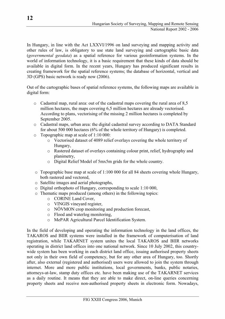
1. The first level is the passive GPS network. This was established in 1991, creating a 24 points frame. This frame has been fixed to EUREF by 5 points, therefore its reference system is the ETRS89. The densification of these GPS points was performed between 1995 and 1997. Totally there are 1153 control points in the network with an average distance of 10 km that is called Hungarian National GPS Network (HGN, exactly: HGN1995, because of the creation date). An HGN Database was created, which contains the most important data of the GPS control sites as site identifier, the EUREF and the EOV horizontal co-ordinates as well as the site location, textual description and scanned site sketch.
In Hungary, the Satellite Geodetic Observatory (SGO) of FÖMI (Penc) is responsible for the Hungarian GPS Network activities. Using the new long-time GPS measurements, they computed the new GPS reference frame called HGN2002, connecting the Hungarian frame to ETRS89 with 9 points. This new epoch is not in practice; there is a discussion now, how to use this new frame in practical applications.
15 Hungarian Society of Surveying, Mapping and Remote Sensing National Report 2002 - 2006
FIG XXIII Congress 2006, Munich
Fig. 1. 1153 points of the Hungarian National GPS Network (HGN)
It is essential that all these GPS points are identical with the horizontal control points (HD72) and 350 points have levelled heights as well. The common points can create similarity transformation parameters between GPS system and HD72 datum. The maximal residuals are about 0.5 meters at the edge of the network, so these nationwide parameters are mainly for GIS purposes. These parameters were published and set to Hungarian DAT standard. For geodetic purposes local transformations are used. The HGN allows performing local transformation anywhere in the country with the standard error of 2-4 cm. In 2004, a free transformation software was published by FÖMI to spread this information.
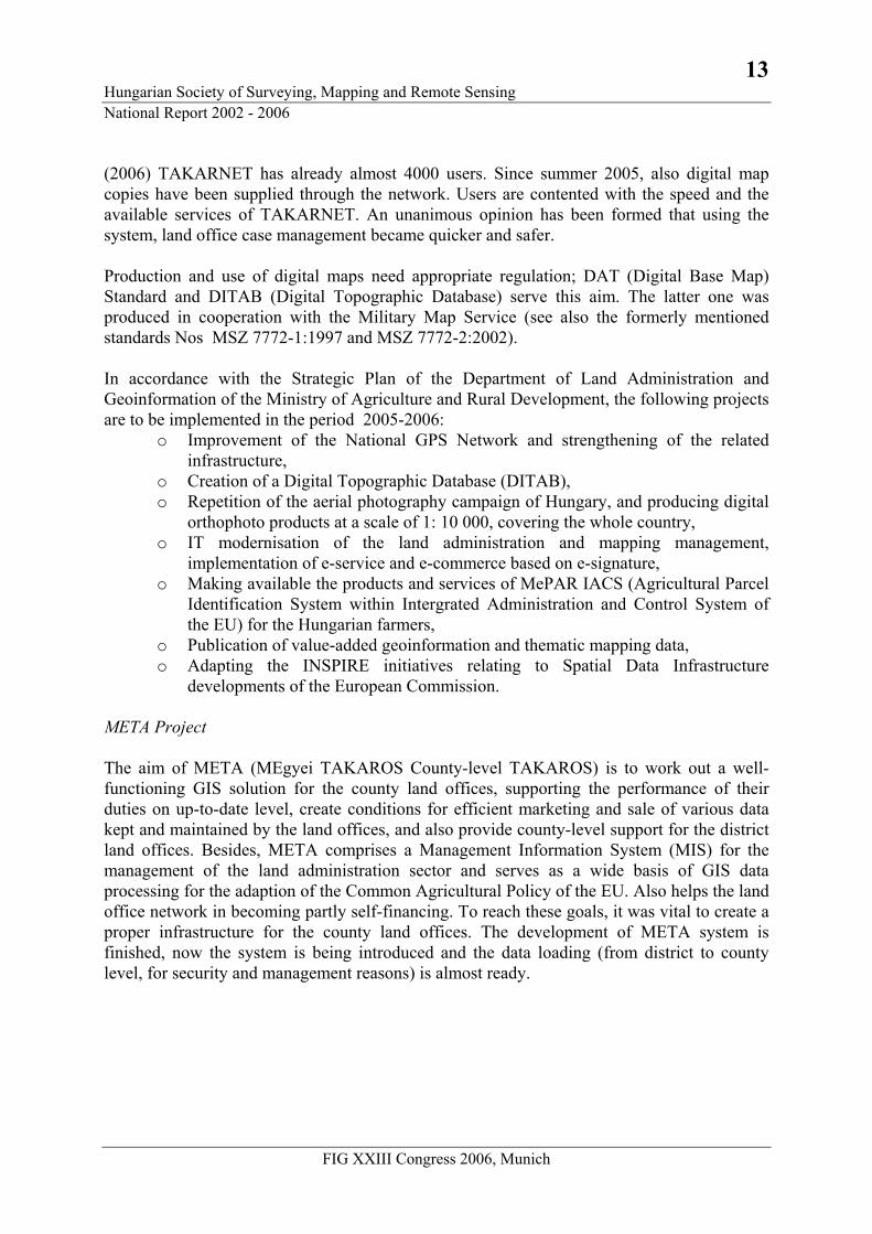
Fig. 2. Twelve points of the state owned active GPS Network
with the dates of establishment
2. The second level of the infrastructure is the active GPS network. In accordance with the plan, there would be 12 permanent stations, but only 10 stations had been installed by the beginning of 2006. The average distance between these planned permanent
16 Hungarian Society of Surveying, Mapping and Remote Sensing
National Report 2002 - 2006
FIG XXIII Congress 2006, Munich
stations was 100 km providing 50 km baseline solutions in the most unfavourable arrangement. The coordinates of the permanent stations are based on the HGN1995 datum. The active network and its services are called GPSNET.HU. A web server with the same name has been installed, which provides access to all related information and RINEX data. RINEX files are stored hourly and for a twenty-four hour’s period of time. The development, maintenance and data analysis are done at the FÖMI SGO. More and more users download data to post-processing through internet. The greatest advantage of the second-level infrastructure is that there is no need for reference station set by the user.
3. The third level of the infrastructure is the real-time operated Network RTK service.
The corrections are transmitted by the reference stations to the centre through TCP/IP port at each second. The processing centre is installed and maintained by SGO of Penc. The first server was put on in April 2004. The SpiderNet and GNSMART software were installed during summer 2005, being able to compute experimentally the corrections of VRS, FKP and MAC. The task of NtripCaster is the multiplication of data in order to transmit them to the registered users.
There are two types of real-time services, namely, the availability only code (sub meter precision DGPS service) or code and phase observations (centimetre precision RTK service for single base and networking).
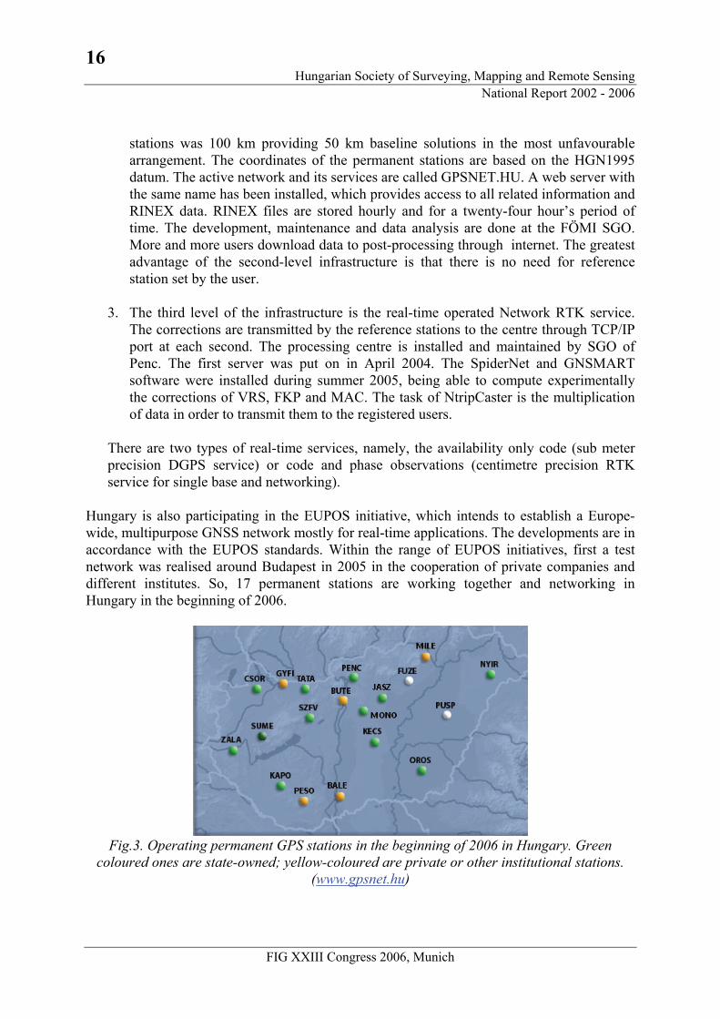
Hungary is also participating in the EUPOS initiative, which intends to establish a Europe-wide, multipurpose GNSS network mostly for real-time applications. The developments are in accordance with the EUPOS standards. Within the range of EUPOS initiatives, first a test network was realised around Budapest in 2005 in the cooperation of private companies and different institutes. So, 17 permanent stations are working together and networking in Hungary in the beginning of 2006.
Fig.3. Operating permanent GPS stations in the beginning of 2006 in Hungary. Green
coloured ones are state-owned; yellow-coloured are private or other institutional stations. (www.gpsnet.hu)
17 Hungarian Society of Surveying, Mapping and Remote Sensing National Report 2002 - 2006
FIG XXIII Congress 2006, Munich
In Hungary, similarly to any country across the world, the positioning technologies formed from traditional triangulation and traversing gradually throw the static GPS observations to the network RTK solutions. Now we are using the traditional angle and distance measurements, the static and kinematical GPS together. The applied technology depends on the instrumentation and the users’ needs. We can state that GPS technology became most popular in the last four years thanks to its effectiveness. Mainly in the geodetic positioning (control point densification) it has an important role, because there was a real need for detail survey producing large scale maps, and it also needs a large amount of control points. The RTK kinematical technology we also start to use, especially in motorway building, setting up and cadastral survey. To properly introduce the new technologies into the practice, professional education and regulations are necessary. The MFTT has duties and experience to spread these new kinds of knowledge, too. We can mention the conferences of about the new technologies, like “GPS in agriculture in the year of enlarging European Union”. There were some initiations to regulate position fixing, but without real results. The discussions about regulations and standardization in positioning and measurements are going on.
8. Cadastre and Land Management Issues The current system of the Hungarian unified land registration was created in 1972, when the two registers – the Cadastre and the Land Records (“Grundbuch”) – were integrated based on legislation and realised on institutional level; the land office network was formed. As a result of the unified system, parallel practice of updating was cancelled: both legal and mapping changes concerning the landed properties are recorded practically at the same time, in the same institutional system. The Department of Land Administration and Geoinformation of the Ministry of Agriculture and Rural Development directs and supervises the land offices. FÖMI, (Institute of Surveying and Remote Sensing) as a background institution provides technological support to them, besides its main duties of land surveying, mapping and remote sensing. The Hungarian unified land registration system keeps about 10 million landed and other properties, including condominiums, etc. The cadastral maps at scales 1:1000-1:4000 cover the whole territory of Hungary. The land offices keep records not only of the ownership rights in land, but also of the land lease. The duty of land offices is to record the changes in facts and data of rights (ownership rights, mortgage, easements etc.) in land and other properties, parallel with updating the content of cadastral maps. The registration and maintenance of geodetic control points form also the duty of land offices. In Hungary, the annual number of applications submitted to land offices for changes to update is about 4 million.
18 Hungarian Society of Surveying, Mapping and Remote Sensing
National Report 2002 - 2006
FIG XXIII Congress 2006, Munich
The data carrier of all legal data registered in the system, the property sheet is already in digital form, and by now, also 90% of the cadastral map content is digitised. The property sheet data are available through internet, too. The digital cadastral maps are mostly prepared within the National Cadastral Programme. The idea of National Cadastral Programme was born in 1994, the implementation started in 1996. From professional aspects, the necessity of starting the programme was that that the majority of the maps were in different projections and mapping systems, nearly all of them in analogue form. (Approximately 60 000 cadastral map sheets cover the area of Hungary at scales from 1:1000 to 1:4000. A large part of the sheets were in different projections, mapping systems and datum: stereographical, cylindrical etc. Around 4 % of the map-sheets were available in digital form). Professionals and surveying and mapping companies are contracted by the NCP Public Benefit Co. to carry out the digital cadastral survey in standardised form and the digitisation for rural areas. The Department of Lands and Mapping of the Ministry of Agriculture and Rural Development has drawn up the proposal for the continuation and acceleration of the National Cadastral Programme. In connection with the relevant measures it organized a conference titled “Information society and the National Cadastral Programme” with the President of the Hungarian Academy of Sciences, and the Minister of Agriculture and Rural Development as chief patrons. The conference clearly confirmed the need for the continuation of the National Cadastral Programme: the main aim of the Programme is to produce digital cadastral maps in vectorised form throughout the country. A two-step solution was proposed: The first measure is to ensure the digitisation of existing analogue maps starting with the rural areas (currently underway). Since January 2004, the process also includes the county seats, major towns and other settlements. At present, 52 000 square kilometres of rural area have been processed, for which the vectorised maps are completed in DXF format. The rest of the rural areas was completed by December 2005. A further 2 000 square kilometres of urban area is being processed, with a targeted completion date of end-2005. Digital processing of the rest of the urban areas is planned to start in early 2006. As the first step (measure), vectorised maps will cover the whole of the territory of the country by the end of 2007. Estimated cost of this work is 9.8 billion HUF (about 40 million Euro). In the second measure, the aim is to make digital maps that correspond to DAT Professional Rule System using modern field methods of data collecting, and field measuring techniques. The proposed starting date of this measure is 2008. It is the duty of the land administration, together with FÖMI to organise the state acceptance procedures and the final official acceptance of the new, digital cadastral maps. FÖMI has the same task concerning topographic maps, too. FÖMI is responsible for the maintenance and
19 Hungarian Society of Surveying, Mapping and Remote Sensing National Report 2002 - 2006
FIG XXIII Congress 2006, Munich
updating of the database of administrative boundaries and maintenance of the national horizontal and height control networks. In Hungary, documents generating changes in the facts and rights in land can only be issued by lawyers. Cadastral land surveying or mapping jobs can only be performed by registered land surveyors possessing special permit for that activity. Mostly the private sphere is producing digital cadastral maps and are performing cadastral measurements. In Hungary, the property reform – started in 1990 – has resulted in a great increase in the number of properties and parcels. From the previously homogeneous large estates, hundreds of thousands of small parcels were created. The use of the arable lands mostly does not coincide with the ownership rights. For that reason, the most important provision of the amendment to the Act on Arable Land was the introduction of the land use registration on 1st January 2000. The main ordering principle of the land use registration and that of the land registration is different. In land registration, the property is the basic item – it means that all additional data are gathered into groups around these items. The land use registration is managed in each District Land Office for its territorial competence. The land use sheet contains all the parcels of a land user on the territory of the given Land Office. The land use sheet consists of two parts. The first part contains the land user’s data; the second part contains the used land’s data. No registration of land use is required for a land property with a size less than 1 hectare. The land use registration system called FÖNYIR has been elaborated and installed at the District Land Offices by FÖMI in 2000. From this year on, the land users have been registered at the District Land Offices. The tasks of the Land Office network concerning land use registration are as follows: to register the changes continuously, to detect those who failed to register and to increase the correctness of the registration. Further tasks are: optimise the computer programs that maintain the land usage announcements in order to accelerate the processing and to enlarge the range of queries and make them more comfortable for users. In Hungary, the land valuation system introduced in the second half of the 19th century called Golden Crown system is still in power for expressing the value of the land. Since its introduction, this system had served its original purpose more or less well. Recently, the system and its method became outdated, however, it is still in power and use. The land parcels are registered by District Land Offices, using the Golden Crown system. Its survival might contribute to the fact that the arrangement of the land ownership conditions, the land compensation, the re-allotment of lands to the co-op-members on the basis of the original value of the given property and, in general, the privatisation needed the value of lands in old Golden Crown system. In fact, it has been connecting the past and the present. The Golden Crown system indicating the quality of the land highly promotes the rearrangement of the property conditions. Consequently, at least till the completion of that rearrangement, the validity of the Golden Crown system should be maintained. Arable lands can be used for non-agricultural purposes only by the leave of authority. To the utilisation of arable lands for industry, mining, water conservancy, transport, community
20 Hungarian Society of Surveying, Mapping and Remote Sensing
National Report 2002 - 2006
FIG XXIII Congress 2006, Munich
development and/or other purposes, a permit has to be granted by the Land Offices. However, the utilisation of arable land under permission does not provide preventing force all by itself and further, the areas should be compensated, which inevitably have to be used to investments. Therefore, in case of non-agricultural utilisation of arable land, besides the permission, a land protection fee should be paid by the user, too. As an undesired by-product of land privatisation carried out in the last decade, scattered property patterns have been formed in Hungary, e.g. properties of arable lands belonging to one single landowner dispersed in 5-10 different field units, far from each other. This situation is very disadvantageous from the point of view of economical production. To overcome this, the present legislation offers one possibility: spontaneous land exchange. Arrangement of such exchanges, especially in the case of several property owners, needs much skill and proficiency. Therefore, since the possibility is legally given, those intending to exchange their lands would rather do request the assistance of the competent land office. In connection with land utilisation, Land Offices have a dual task: checking the obligations of farming the land and promoting land consolidation by means of spontaneous land exchanges. Commission 7 is the flagship and most active Commission of FIG. Since 15 years, Commission 7 has organised Annual meetings in different country, separately from major FIG events. The generally one week meeting includes 1-2 days open symposium in a selected topic relevant to Commission 7 activities and also important in the host country. The Hungarian delegate András Osskó has been active member of the Commission since 1995, chairing Working groups during the 1998-2002, 2002-2006 period and also chair elect 2007-2010 Between 2002-2006 under Paul van der Molen chairmanship, Commission 7 extended its activities, co-organising symposiums, workshops, expert group meetings together with UN organisations like HABITAT, FAO, on land administration matters in different region. These events have been great success because development and modernisation of land administration is very important issue world wide as the infrastructure for sustainable development and economic growth. András Osskó participated in all major FIG conference, Annual meetings and the majority of other events.
9. Spatial Planning and Development The Hungarian Commission 8 undertakes a dual job. On the one hand, they discuss the questions of the Hungarian practice of planning at professional forum, on the other hand, following the themes of Working Programme of International FIG Commission 8, they monitor the achievements, and try to make use of them in the national planning activity. In the past period and also currently, the Hungarian spatial planning activity can be characterised by preparations to cope with the requirements of being a full member of the EU. The most important task is to produce those plans and programming documentation, which help to gain the EU subsidies and also to create the necessary institutional system. The
21 Hungarian Society of Surveying, Mapping and Remote Sensing National Report 2002 - 2006
FIG XXIII Congress 2006, Munich
responsibility of producing EU planning documents, their acceptance procedure and implementation belongs to the National Development Office (NFH). The regional planning activity is the duty of the independent Hungarian Spatial and Regional Planning Office, the settlement planning belongs to the Ministry of Internal Affairs, while the Ministry of Agriculture and Rural Development is responsible for rural planning. The regional and settlement planning is regulated by rules of law (Act on spatial development and construction). The required content of plans, methods of agreement and order of acceptance are specified by rules of law. The reform of the Hungarian public administration system has started, to which the decentralisation of a planning institutional system can also be connected. As new elements, small region development councils will be formed, following those of the country, the region and the county level, to fulfil planning duties in the small regions. Professional circles are of the opinion that – to cope with the new challenges – it is necessary to renew the national planning practice. More project-oriented, more flexible sorts of planning should replace the traditional, inordinately static planning methods. More important part should be given to studies on the environmental, social and economic impacts and the social/civil participation in the planning.
10. Quality Management Issues The ministerial executive order of the Act LXXVI of 1996 on Surveying and Mapping Activities says that all the surveyors producing so-called national base geodata must have a quality management system covering the International Quality Standards. The Act also says that the Land Offices managing the land surveying and maintaining maps and data must also have their own quality management system covering the International Quality Standards. The quality control of cadastre is the responsibility of Institute of Geodesy, Cartography and Remote Sensing (FÖMI) as a central surveying organisation. The quality management system (QMS) of FÖMI based on the Standard ISO 9001:1996 was certified in 1999 by the Bureau Veritas Quality International (BVQI). The validity of the certification expired in 2002. The quality system of FÖMI was reconstructed by the new modified Standard ISO 9001:2000. After putting it into operation, it was certified by BVQI. FÖMI is responsible for very valuable databases at different fields, including TakarNet, the nationwide real-estate-registration network service. That is why it is very important the security of the datasets both in physical and legal aspects. To save and guarantee it, the Institute has created an Information Security Management System (ISMS) by the British Standard BS 7799. The management system was certified in 2003 for three years by Society General of Surveillance (SGS) Hungary Limited.
22 Hungarian Society of Surveying, Mapping and Remote Sensing
National Report 2002 - 2006
FIG XXIII Congress 2006, Munich
Having regard to the coming expiration of QMS Certificate, FÖMI decided to create a new management system with the integration of the QMS and ISMS. The expected advantages of integration the different management systems are: reducing management costs, increasing the management efficiency, reducing the live inputs for management activities, to provide bigger capacity for productive works. The new IMS is carried out, and put into operation from January 2006. A tender was called to certify the Integrated Management System. The winner of the tender is SGS Hungary Ltd., the same company who earlier certified the present ISMS. The planned date of certification audit of IMS is in April 2006. At the end of the year 2000 FÖMI got the certification as an accredited calibration laboratory for the Gödöllő Base Line. The Hungarian National Accreditation Board issued the certification. In possession of the certification, FÖMI is authorised to calibrate distance measuring devices and total stations used for creation of national basic geodata. The activity of the Calibration Laboratory was extended in 2002 for calibration of GPS devices. The Hungarian National Accreditation Board issued the certification of the Calibration Laboratory for the extended activity.
11. Conferences, workshops Hungarian specialists held several presentations in the period 2002 - 2006:
o Our Reference Basic Data in the National and European Spatial Data Infrastructure. Conference on Geodesy, Economy and Informatics, November 2004, Budapest Cross-Border Activities and Projects in Geoinformation. Conference „Geoinformation Verbindet Nachbarn”, Vienna, 26 November 2004.
o Papers presented at the Annual GIS Conference held in Szolnok are always successful. It was the same in 2004, where, among others, the audience followed the papers belonging to the profile of FIG Commission 3 with keen interest.
o FIG 7 held its annual assembly from 8 to 14 September 2004 in Clermont-Ferrand, France. A two-day open symposium (Modern Land Consolidation) also formed part of the one-week assembly, where András Osskó and Enikő Kovács delivered their presentations on the experience concerning Hungarian land consolidation.
o Hungary was represented at the conference „Standardisation in Cadastral Model”, 9-10 December 2004, jointly organized by FIG Commission 7 and the „COST Action G9” Project. Gyula Iván presented his paper: “Standardisation and New IT Development in the Hungarian Cadastre”.
o Hungarian Members of the FIG Commission 3 have systematically and actively been attending major FIG events. Efficiently contributed to the Working Week held in Athens, May 2004. With the officials and members of the Commission, a friendly relationship has been formed and maintained, taking significant part from the duties of the Commission, with special attention to the Working Group 3.3. Within this, a study is being written (“Current Situation of the GIS Management”) and a metadatabase is being created, with the participation of the Hungarians.
23 Hungarian Society of Surveying, Mapping and Remote Sensing National Report 2002 - 2006
FIG XXIII Congress 2006, Munich
FÖMI, being major operative organisation of FIG HNC 3. Commission, applied for and won the category “Affiliate Membership” at the FIG General Assembly held in Athens, 2004. Winning the “affiliate” membership is the recognition of FÖMI experts’ active participation in FIG’s work. Also MFTTT expressed its appreciation and respect. Hungarian Papers presented to FIG Conferences and Working Weeks FIG Conference, Washington DC., 2002:
o Heine, E. - Mansberger, R. - Ágfalvi M. - Márkus B. - Nyiri J.: Assessment and Analysis of Property and Land Use Changes in the Cross Border Region Austria – Hungary
o Márkus, B.: Spatial Knowledge Management in Land Administration Annual Meeting of Commission 7, Pretoria, South- Africa, 2002 o Osskó, András: Compensation, Land restitution procedures in CEEE Annual meeting of Commission 7, Krakow, Poland, 2003
o Osskó, András: Customer service of the Unified Land registry system in Hungary in respect of EU requirement
FIG Working Week, 2003, Paris:
o Forgács, Zoltán: The Application of Digital Maps in the Juridical Practice o Kovács, Enikő – Király, Tibor: Information Management at the Hungarian Land
Administration by Using Internet. o Márkus, Béla: Educational Portal Development
2. FIG Regional Conference, 1-7 December 2003, Marrakech:
o Hőna, Eszter: The Role of Spatial Plans in the Preparation of Land Consolidation in Hungary
o Kovács, Enikő: Is Land Consolidation Just a Dream in Hungary? o Mihály, Szabolcs: Hungarian Approach to the Model of Database for Unified Land
Registry o Mihály, Szabolcs: Space Referencing Core Data for GI in Hungary
FIG Working Week, Athens, 2004:
o Márkus, Béla: Curricula Development in Bologna Process FIG Regional Conference, Jakarta, Indonesia, 2004:
o Márkus, Béla: Future Education - FIG Commission 2 Perspectives o Márkus, Béla: GI Support for Land Consolidation
Annual Meeting of Commission 7, Clermont Ferrand, France, 2004
o Osskó, András – Iván, Gyula – Kovács, Enikő: Land consolidation in Hungary, dream or reality
24 Hungarian Society of Surveying, Mapping and Remote Sensing
National Report 2002 - 2006
FIG XXIII Congress 2006, Munich
Expert group meeting on “Secure Land tenure in Africa” Joint FIG Commission 7/ UN HABITAT Nairobi, Kenya 10.12 November 2004 András Osskó FIG Working Week, Cairo, 2005:
o Márkus, Béla: Learning pyramids Conferences, Workshops organised in Hungary 2002:
o GIS Open 2002. (11-13 March 2002, Székesfehérvár) o Agroinformatics 2002. (27-28 August 2002, Debrecen) o 6th GSDI Conference (17-19 September 2002, Budapest) o Further Training in Geomatics(17-18 October 2002, Sopron) o 12th National GIS Conference (14-15 November 2002, Szolnok)
2003:
o GIS Open 2003. (10-12 March 2003, Székesfehérvár) o Forum on Land Use and Area Utilisation (3-4 April 2003, Székesfehérvár) o Hungarian – French Conference on Land Administration (14-16 May 2003,
Budapest) o 4th EFITA Conference (5-9 June 2003, Budapest, Debrecen) o MFTTT Itinerary Conference (10-12 July 2003, Debrecen) o 13th National Conference on GIS (25-26 September 2003, Szolnok) o “Ligth – Space – Image” Conference ( (6-7 November 2003, Dobogókő) o Meeting on National Cadastre Programme, Budapest, 2003:
Márkus, Béla: Educating Experts for land administration and the digital mapping technology; Márkus, Béla: Information Society and the National Cadastre Programme.
2004: o GIS Open 2004. (16-17 March 2004, Székesfehérvár) o GPS in the Agrarian Sector (MFTTT, 29-30 April 2004, Budapest) o 14th National Conference on GIS (2004. szeptember 23-24. Szolnok) o “Light – Space – Image” Conference 2004 (7-8 October 2004, Dobogókő) o Further Training in Geomatics (28-29 October 2004, Sopron) o Geodesy – Economy – Informatics (4-5 November 2004, Budapest)
2005:
o GIS Open 2005. (16-18 March 2005, Székesfehérvár) o International Conference on Agroeconomics, Rural Development and
Agroinformatics (7-8 April 2005, Debrecen) o UNECE/WPLA Workshop (7-8 April 2005, Budapest)
25 Hungarian Society of Surveying, Mapping and Remote Sensing National Report 2002 - 2006
FIG XXIII Congress 2006, Munich
o Changing Regulations in the Land Administration (MFTTT Conference, 28-29 April 2005, Budapest)
o Geoinformation in the Technology (12-13 May 2005, Szeged) o MFTTT Itinerary Conference (30 June – 2 July 2005, Győr) o Agroinformatics 2005. (23 August 2005, Debrecen) o 74th National Exhibition and Fair of Agriculture and Food Industry (27 August – 4
September 2005, Budapest) o 15th National Conference on Geoinformation (4-5 October 2005, Szolnok) o “Light – Space – Image” Conference 2005. (10-11 November 2005, Dobogókő) o "The National Digital Cadastral Map of Rural Areas is Ready!” ( MFTTT
konferencia, 24-25 November 2005, Budapest) o „For an Ambrosia-free Hungary”, Conference (15 December 2005, Budapest)
2006:
o GIS Open 2005. (16-18 March 2006, Székesfehérvár) o 9th AGILE International Conference on GI (20-22 April 2006, Visegrád) o FIG Commission 2 workshop (27-29 April 2006, Budapest)
For more information:
www.mfttt.hu www.fig.hu www.agile2006.hu www.geo.info.hu/gisopen
Budapest, February 2006 Prof. Dr. Béla Márkus Ms Piroska Zalaba President of FIG HNC Secretary of FIG HNC