Embed Size (px)
Citation preview

Shortened version
Culture historical significance on areas Tasersiaq and Tarsartuup Tasersua in West Greenland & Suggestions for Salvage Archaeology and Documentation in Case of Damming Lakes
- Report prepared for ALCOA, - May 2009.
By Pauline K. Knudsen
Nunatta Katersugaasivia Allagaateqarfialu Greenland National Museum and Archives
May 2009

2
Table of Contents
Introduction……………………………………………………………………………….. 3
The Culture historical background………………………………………………………... 4
Results from the surveys………………………………………………………………….. 5
Finds by Lakes in Nuuk area, 6g ..……………………………………………………… . 6
Finds by Tasersiaq, 7e……………………………………………………………………. 9
The Culture Historical Significance of Finds……………………………………………... 13
Suggestion for Preservation of Tasersiaq…………………………………………………. 15
Suggestion for Salvage Archaeology and documentation in Case of Damming of
Lakes……………………………………………. ………………………………………… 17

3
Introduction Archaeological studies were performed by Greenland National Museum in 2007 and 2008 on
main impact areas in advance of ALCOA’s proposed aluminium smelter. Initially archaeo-
logical surveys were undertaken at three areas chosen as water reservoirs for the hydroelectric
plants to supply the aluminium smelter with electricity. When plans called off using the
middle reservoir, Isuup Tasia (7d), it was excluded from the 2008 studies.
Awareness of the significance of the interior resources exploited by past cultures exists
through traditional and historical sources. Some areas of the north reservoir, Tasersiaq (7e)
had also been partly surveyed by archaeologists from the National Museum in Denmark in
2002. In spite of knowledge from these sources the amount of new finds both in the north (7e)
and south reservoir (6g) areas were astounding. The importance of the caribou hunts in the
interior and the use of the big lakes for that activity is now obviously cemented by the amount
of mapped cultural remains as regards the Inuit. Samples collected from Saqqaq Culture
settlements by Tasersiaq produced 14C dates telling that the very first people of West
Greenland from an early period exploited the resources of the interior. Special attention is to
be regarded to the complexes of unique and largely undisturbed contiguous cultural landscapes
of the interior where traditional knowledge and legends of cultural significance for the
Greenlandic population are associated. The type of base camp dwellings found in most Inuit
settlements in the Nuuk area (6g) was different in architecture from tent houses usually found
in other areas. This type of dwelling is in this paper designated as stone huts, but in tables and
diagrams the stone huts are put under the category of tent houses. The two published reports
on the archaeological surveys for ALCOA constitutes the backgrounds for this summary. For
the elaboration of the culture historical significance of the finds a list of references can be
found at the end of the paper.

4
The culture-historical background
West Greenland was for the first time settled by Stone Age hunters approximately by 2400
BC. Remnants from these people are named the Saqqaq Culture. As all following arctic hun-
ters to populate Greenland they were migrants from the arctic North America. Finds from the
culture are known from all over West Greenland and way up along the East coast. Large scale
excavations at two localities and finds from another place indicate the importance of caribou
as resource for the Saqqaq people (Meldgaard, 2004 and Gotfredsen & Møbjerg, 2004).
Whether a cultural transition happened from Saqqaq to Early Dorset is being discussed as the
gap with no archaeological finds especially in Sisimiut area is closing. Radiocarbon dates tell
of the presence of Greenland Dorset (Early Dorset) in West Greenland in the period 700 BC –
200 AD. Both the Saqqaq and Dorset Cultures are included under the term: Paleo-Eskimo
cultures.
The next people to populate part of West Greenland were the Norse that, according to the
Sagas, migrated from Iceland around 985 AD. They settled in the Eastern Settlement in South
Greenland and in The Western Settlement in the fiords behind Nuuk. The Norse disappeared
from the latter area by the middle of the 14th
century and totally abandoned Greenland in the
middle of 15th
century.
During the 13th
century the Inuit – people of the Thule Culture - entered the northern most part
of West Greenland and spread out along all coastal areas of the country in the following centu-
ries. Probably the Inuit encountered the Norse, as archaeological finds from the Nuuk area
indicate contemporary presence in the area. Like the Inuit from their origin in the North
Western part of Alaska hunting large whales was important for their livelihood. As Inuit
adapted to the local conditions, especially the cooling of climate in the 16th
- 17th
century
affected their patterns of residence, hunting large whales became limited to few areas on the
West Coast. Around 1650 long distance exchange of resources along the west coast were
established and trade with European explorers and whalers are known from the 17th
century.
After the beginning of the gradual Danish-Norwegian colonisation in 1721 AD, approximately
by 1800 AD Inuit living on the West Coast became dependent on western goods and was by
and large converted to Christianity.
Diag. 1: Presence of past peoples in the research areas.
Results from the surveys Damming lakes in the interior, close to the ice cap, will create two water reservoirs. The redi-
rected outflows will supply hydroelectric plants to generate power for the aluminium smelter.
Damming of Tasersiaq (7e) will raise the waterline by 20 meters. In the southern reservoir
lakes will be merged by damming and affect elevation of water lines differently. Tarsartuup
Tasersua: 10 m, Qaamasoq; 2 m, an unnamed lake: 5 m and Tussaap Tasia: 15 m.

5
Map 1: Both reservoir
areas are situated at
places where Inuit ac-
cording to historical
sources, at least from
the 18th
century, was
summering to hunt
caribou. Both areas
were renowned to
attract people also from
distant areas on the
West Coast. After long
journeys by boat and
foot the families stayed
in dwellings for several
months in the interior.
Caribou hunting by
Tasersiaq ceased
around 1950 and
summering by Tarsar-
tuup Tasersua already
by 1920. Hunting trips
in the latter area contin-
ued into the 1970’ies.
Diag. 2: The diagram shows mapped cultural remains from the two survey areas sorted by
functional types. The largest structure being a tent house is a construction of stone walls to be
roofed with skins for housing of the hunting family at the base camp. Play houses are minia-
ture of dwellings. The stones forming the tent ring weigh down the skin/canvas to the ground.
A frame of stones filled with twigs functioned as an open air bed for a hunting party. Rock
shelters hunter’s beds were used during hunting trips away from the base camp. Single cairns
are markers in the landscape. Cairns systems are for driving caribous in certain directions
during the hunt and shootings blinds are made for the hunter’s concealment. Use of the latter
two types ceased, when hunting with rifle became customary around 1800 AD. Other struc-
tures are cultural remains which could not be functionally defined into certain types.

6
Tasersiaq, 7e
group of cultural remains
base camp
dwellings
29%
other
8%
rest of
structures
24%
Saqqaq Culture
6%
hunting
structures
13%
temporay
dwellings
20%
Lakes by Nuuk, 6g
groups of cultural remains
hunting
structures
2%
temporary
dwellings
28%
Saqaq culture
3%
rest of
structures
15%
other
4%
base camp
dwellings
48%
Diag. 3: One has to be cautious not to ascribe too much meaning into the pattern of the finds,
as only the finds from the narrow area around the lakes to be flooded have been mapped. From
the distribution of the types of grouped cultural remains it is obvious that the base camps and
temporary dwelling remains in the Nuuk area comprise a significantly high share of the finds.
Probably in this area the hunting grounds are situated some distance from the lakes and the
amount of the temporary dwellings are consistent with the latter use of the area.
Finds by lakes in Nuuk area, 6g
Fig 1: The base camp dwellings in the
Nuuk area are different from those at other
areas on the West coast, as they are built
solely from flat stones and accordingly they
are designated as stone huts.
It inevitably calls to mind a possible influ-
ence from the Norse living in the fjords of
Nuuk, when the first Inuit settled in the
area. It should also be mentioned that the
huts resemble those of the early Thule
Culture winter house architecture in
Northern Greenland.
Fig. 2: Aron’s water coloured
illustrations of stone huts from
a caribou hunting camp in the
Nuuk area from the 19th
century.

7
Map no. 2: Lakes in the southern reservoir area. Sites 64V2-0IV-071 and 65V20II-002 will
remain above the water line after damming of the lakes.
In the area by Nuuk the distribution of cultural remains is not distinctive. From oral sources
and archaeological surveys it is known that the areas north and east of Tarsartuup Tasersua are
hunting grounds, which seems to confer with the survey results, as only four sites were found

8
containing a total of four tent houses, two hunter’s bed and three tent rings. Along the rest of
the shores of the lake eight settlements are distributed, the majority situated on the southern
and western shores. As regards Tussaap Tasia it seems reasonable to discern between western
and eastern shores. The eastern shore was probably intended for base camps as two large
settlements with a total of 22 tent houses are situated on the shore and on an island close to
shore. Only one settlement with 3 tent houses is to be found on the western shore together with
another site comprising 8 hunter’s beds.
Fig. 3: A new type of
structure was discove-
red in the Nuuk area.
A circle of stones con-
taining a big slab inside
was recorded at two
settlements.
Fig. 4: A shooting blind on the shore in the
narrowing before the outflow of Tarsartuup
Tasersua. Caribou trails on the shores of the
channel indicate a crossing place. Hunters took
advantage of the vulnerable situation to kill
swimming animals from kayaks. On the pro-
montory visible just above the blind, three hun-
ter’s beds were found. Probably they were look
outs for crossing animals. Surviving animals
were probably taken from the shooting blind as
they reached the shore.
Radiocarbon dates from site 64V2-IV-70 tell of Inuit’s activity in the area at least from the
16th
century. For detailed information on radiocarbon dates see appendix C.

9
Localities at by Tasersiaq, 7e
Map 3: The western part of Tasersiaq is protected from cold winds from the ice cap to the east and accordingly more lush and probably more
rich in game. May be that is why most sites are to be found here. Notice the aggregation of cultural remains by the constrictions of the lake.
10
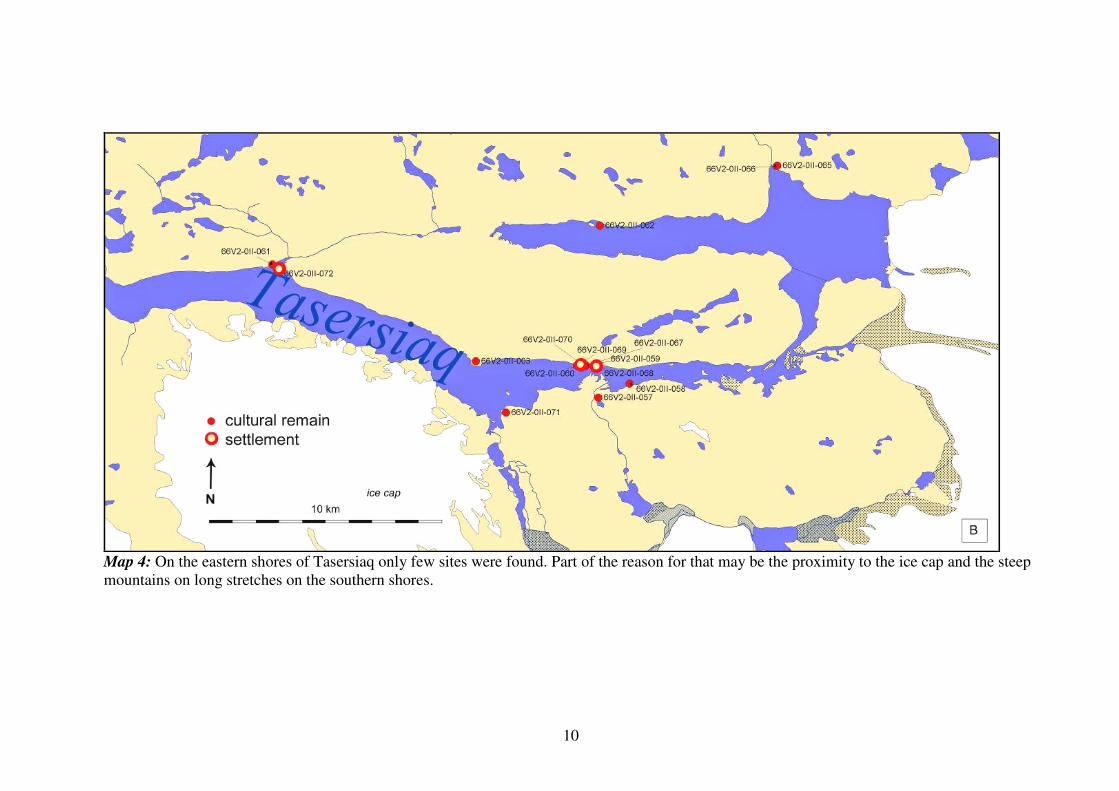
Map 4: On the eastern shores of Tasersiaq only few sites were found. Part of the reason for that may be the proximity to the ice cap and the steep
mountains on long stretches on the southern shores.

11
The distribution of types of cultural remains between opposing lake shores by Tasersiaq shows
how areas in the landscape are singled out for certain purposes. On the northern shore mainly
dwelling structures (73 %) are to be found, whereas on the southern shore it is mainly hunting
structures (83%). Probably this is why, as it can be seen from maps 3 and 4, the density of
cultural remains are so profound by the constrictions of the lake, where crossing between base
camp and hunting areas likely will be more convenient.
A
Tasersiaq northern shore
tenthouses
73%
hunting
structures
27%
B
Tasersiaq southern shore
tent houses
17%
hunting
structures
83%
Diag. 3A & B: Distribution of types of cultural remains on opposing shores of Tasersiaq
Figure 3: A small cairn system by Tasersiaq. Map 4: Distribution of cultural remains in part of
Cairns are marked with white circles. south-western shore of Tasersiaq.
An example on the use of the landscape by Tasersiaq is illustrated in map 4. Site number
66V2-III-093 (Issormiut) is a base camp comprising five tent houses. The settlement 66V2-III-
173 does not have as substantial dwellings, probably because it was used mainly as a tempo-
rary camp in a shorter period of time. As can be seen, most of the shooting blinds and all cairn
systems are situated by lakes. The complex of settlements and hunting structures are situated
in a broad valley were the lake south west of Tasersiaq are in the centre.

12
Fig. 4: Cultural remains from the settlement,
Qoornoq Killeq by Tasersiaq. A is tent ring and
B - D are tent house ruins.
Fig. 4: Water coloured painting
from mid 18th
century by Aron of
Kangeq of the stone the old couple,
who buried their daughter-in-law
alive, when their son died by
Tasersiaq.
Fig. 5: Another painting by Aron
of Kangeq. Aariassuaq frightens
his competitors from his grave on
the shore of Tasersiaq
Radiocarbon dates of two caribou bones collected on the surface by Tasersiaq associated with
cultural remains dated them to between resp. 1301 – 1398 AD and between 1526 – 1663 AD.
Five charcoal samples found in association with five Saqqaq Cultures sites in Tasersiaq had
dates between 2139 – 1779 BC.
For detailed information on radiocarbon dates see appendix C.

13
Culture Historical Significance of the Finds
Fig. 6: View toward west from the east- Fig. 7: Archaeologists looking for diagnostic
ernmost settlement (66V2-0II-067) at tools in a tentring from the Saqqaq Culture at
Tasersiaq. Tasersiaq.
Situated at heights over 600 meters next to the icecap the landscapes in both areas are peculi-
arly beautiful and hunting activity in the areas way up into the 20th century apparently has not
affected the landscape or the cultural remains. The interplay between hunting structures and
landscape features are clearly obvious. More detailed studies are needed to get profound
knowledge of how prehistoric hunters took advantage of the landscape for their benefit. The
coherent complexes of settlements and hunting areas by Tasersiaq make up unparalleled
opportunities for the study of prehistoric Inuit’s activities in the cultural landscapes as traditi-
onnal knowledge from historical use of the landscapes are available. In many aspects the con-
ditions at Tasersiaq are comparable to the landscapes of last Ice Age in the northern hemisphe-
re where caribou hunting was of great importance. For these reasons the contiguous landsca-
pes are of great value for the study of prehistoric hunting activity and the interplay between
human and nature in general.
It is not until this century that larger areas of the interior of Central West Greenland were sur-
veyed by archaeologists. The finds now challenge the widely held view of the relative low
value attributed to the Greenlandic Inuit’s use of the interior and its resources. The new know-
ledge of at least periodically intensive use of the interior indicate more complexity to the Inuit
life style where fluctuations in the animal populations probably was an important structuring
force for the dynamic of the historical progress.
In general for the study of the history of Inuit in West Greenland the interplay between coastal
and interior resources and fluctuations in animal population are fundamental aspects to study
and understand. In that respect interior settlement and hunting areas can help to clarify the
conditions.
Inuit’s combination of coastal and interior resources was rather specialized and complex
compared to hunter – gatherers in general, however the affect on their cosmology is poorly
studied. Some archaeological studies on Inuit’s cultural remains in the Canadian arctic have
touched upon the subject and illuminated that the study of cultural remains combined with
ethnographic and traditional knowledge can give a more profound understanding of the

14
esoteric aspects of Inuit life ways. In that respect the cultural landscapes are important sources
for the study of the Inuit cosmology.
Archaeological studies and excavations at Aasivissuit - a large caribou hunting camp situated
100 kilometers north of Tasersiaq with associated cairn systems for driving caribou, a fence
and shooting blinds - is hitherto the main study of Inuit’s hunting in the interior of West
Greenland (Grønnow et. al, 1983.) The stratigraphy from the midden reveals horizons with
layers of caribou bones of differential thickness. Radiocarbon dating of caribou bones from the
midden correlates the thick layers of bone with historical known periods of large caribou
populations. This supports the traditional indigenous knowledge about fluctuating caribou
herds through times. The amount of cultural remains found on the surveys does indicate an
intensive use of the land, which possibly can be related to the highs of caribou populations.
Fig.8: Illustration of the trading network of the Inuit in West Greenland between 1650 –
1750AD. According to historical sources people from South and South East Greenland
travelled north to trade for soap stone, baleen and presumably also to trade European goods
with the whalers before the establishment of the Danish – Norwegian colonies.
As previously mentioned a trading network along the south western region of Greenland was
maintained during the 17th
and 18th
centuries. The conditions for sustaining the network were
due to a combination of circumstances. Soapstone from deep inside the fjords of Nuuk was an
important commodity in the network. Baleen from the large whales available by the coast
north of Tasersiaq was likewise. The whales were also exploited by European whalers with
whom Inuit traded European goods.

15
The Inuit travellers from south, reported by the first colonists, were considerable in numbers,
as they were counted in hundreds, and had to stay for the winter before returning home. The
pressure on resources in an already populated area can possibly be met by periods with suffi-
cient resources e.g. whales and caribous, but it is known that Inuit from historic periods regu-
lated access to resources mainly through territoriality. The Southerners’ access to whales and
caribou was probably solved by suspension of the territories as is widely known to happen
among a wide range of traditional societies when resources are plenty and predictable.
This very rich period from the mid 17th
to mid 18th
century where people from large stretches
of the coast intermingled and shared ideas in the central area of West Greenland created a
unique situation in the history of Greenland. For the understanding and study of the historic
conditions of this important period that had a great cultural impact on Inuit/Greenlanders the
Lakes by Nuuk and Tasersiaq constitute an important aspect.
Fig. 9: Hunter’s bed and cairn by Tasersiaq.
Suggestion for Preservation of Tasersiaq
Based on the above it must be concluded that the cultural landscapes by the intended water
reservoirs are of high cultural value for the Greenlandic people, research in the Greenland past
and Inuit anthropology. Especially the complex contiguous landscapes where settlement areas
and hunting ground interchange at Tasersiaq is an invaluable testimony to prehistoric and
historic lifestyle of Inuit in West Greenland.

16
As a consequence of the conclusion it is recommended that the cultural landscapes including
the cultural remains by Tasersiaq are to be preserved due to following reasons:
Tasersiaq was a considerable hunting area for a sizeable part of the Inuit population of West
Greenland. Several folktales are associated with specific localities at Tasersiaq, appearing in
sources from i.e. Aron from Kangeq and Jens Kreutzmann and in oral tradition in general.
The large concentration of features indicates that the lakes were very important for hunting,
and that interior regions of West Greenland were more important to the livelihood of Inuit
than has hitherto been assumed. The archaeological remains relating to Inuit activities by the
shores of Tasersiaq include among other 8 base camps, several temporary camps, meat caches,
graves, and several undisturbed hunting drive systems consisting of cairns and shooting blinds.
The settlement of Qoornoq Kangilleq situated on the northern shore and encompassing more
than 40 structures, is particularly important as it is probably the largest caribou hunting camp
in Greenland which also was in use 4000 years ago. The settlement is surrounded by hunting
territories in all directions, including the areas across the lake to the South. The undisturbed
drive hunting systems situated in differing landscapes along the more than 80 kilometre long
lake are also clearly important, yet they have still not been examined thoroughly.
Four camp sites relating to the Saqqaq Culture provide new information about the culture, as it
is the first time that their remains have been found this far inland.
Because the exploration and interpretation of the prehistory of Greenland has hitherto been
conducted solely by Western scientists, it is important to leave these significant archaeological
structures and cultural landscapes on the shores of Tasersiaq for study and interpretation by
Greenlandic archaeologists in the future.
The ability to combine the exploitation of resources from both coastal and interior regions is
one of the central characteristics of Inuit cultures dispersed from the eastern part of Siberia to
East Greenland. In that context, Greenland is special because of its narrow strip of unglaciated
land between the ice cap and the ocean. Early in prehistory, the dichotomy between coast and
interior became reflected in the cosmology of Inuit culture and has been a central part of the
culture up to the historic period. The coast-interior duality which marked prehistoric cultures
is still not sufficiently explored by archaeologists. As the cultural remains by Tasersiaq are
among the most substantial remains relating to interior hunting in the eastern Inuit area, they
have a major importance for the understanding of this special aspect of common Inuit
prehistory.
Hunting structures situated in the undisturbed landscapes of the southern shores of Tasersiaq
yield outstanding possibilities for the study of the hunting methods used by prehistoric hunters
of the European Ice Age because traditional knowledge on the historic use of the area that are
available. The hunting conditions in the area are analogous to those during that important
period in human prehistory. During the Ice Age, caribou hunting had a special importance.
Fluctuations in animal populations had profound effects on prehistoric hunting societies e.g.
on organisation of the hunting. The cultural remains by Tasersiaq in combination with remains
from the coastal areas can contribute to the study of the affects of fluctuating animal
populations in prehistory in general.

17
Suggestions for Salvage Archaeology and Documentation in Case of
Damming of Lakes Tasersiaq, Tarsartuup Tasersua and Tussaap Tasia
For the last 2 years the Greenland National Museum and Archives have undertaken archaeo-
logical surveys, interviews and archival research around Lake Tasersiaq, Lake 7e, in order to
elucidate the antiquarian interests in the area. Some surveys have been done earlier and now
an even more interesting and complex picture has arisen of the cultural-history of the area.
Ca. ten years ago Greenland asked UNESCO that 3 areas in Greenland should be considered
World Heritage Sites. UNESCO later approved the Jakobshavn Isfjord as a World Heritage
Site and maintained the other two on the Tentative List.
The Aussivissuit – Arnangarnup Qoorua (Sarfartoq) area is one of these areas on the Tentative
List. The southern border of the suggested area is just north of Tasersiaq, Lake 7e. The main
argument for nominating the area is the impressive representation of Inuit cultures as seen in
the landscape from the Inland to the Davis Strait.
Based on a request from the Greenland Home Rule, Dept. of Culture, Research, Education and
Church in the fall 2008 the Greenland National Museum recommended that the nomination
should be upheld and informed the Department that “based on the information we (i.e. the
Museum) have today after two years of survey and mapping, we would have included an area
to the south in order to include the area around the largest lake in Greenland: Tasersiaq. The
landscape from just north of Kangerlussuaq till south of Lake Tasersiaq holds a fantastic
cultural landscape - in a Greenland context - which yields information on social, cultural and
natural resources and adaptive strategies, which are unusual among Inuit – at least in the
Eastern Arctic.” (letter and e-mail dated November 26, 2008)
If the planned damming of lakes 6g and 7e takes place two important and unique West Green-
land inland areas will disappear for ever. The investigations which must be undertaken will
reflect that. The list of sites and features to excavate represents what the Greenland National
Museum considers essential and a minimum to do.
It should be kept in mind that in all Greenland (with the exception of Peary Land), only a few
sites along Kangerluarsunnguup Tasersua, the hydropower lake south of Nuuk, and one
prehistoric site in the inland, Aussivissuit, c. 100 km. north of Tasersiaq, have ever been
excavated,
That was in the early 1980’ies and 1990’ies and the research questions asked and the array of
archaeological tools for retrieving information has been incredibly improved since then. This
means that the museum has very little present empirical experience to base our experience
upon.
The list of sites and structures in this Report which must be excavated or documented in other
ways is based on present knowledge, which however may change when we obtain more
empirical information from more field-research.
Some of the methods to be used for documenting the cultural use of the areas are listed below:
The salvage plan will strive towards documenting all sites including their relation to the
landscape and to each other as thoroughly as possible, and to retrieve data which can
contribute with information on the cultural use of and impact on the areas through times.

18
The different methods for documenting the cultural use of the areas are listed below:
o All sites must be mapped in detail including their relation to the landscape, and the
landscapes surrounding lakes must be documented by satellite photos.
o Excavation of all settlements and selected structures outside the settlement areas are
recommended. Settlements must be totally excavated including areas in between the
structures. It is likely that some of the cultural remain are sunken into the lakes and the
lakes may have been used e.g. as middens. As far as possible lake areas bordering
settlements has to be examined in spite of the murky waters. As mentioned in the 2008
survey report some cultural features are sunken into the lake that at times had a lower
waterline. In that respect the lake has also been part of the activity area.
o Structures selected for excavation should be representative of all types of structures in
their diverse designs through times (a list of types of structures appears from the
appendix A). Some features can not be excavated because they are built of stones on
rock e.g. fox traps, cairns, some shooting hides, cairn systems, etc.
o Regarding structures from the Paleo-Eskimos all finds will be excavated, as remnants
from that period from the interior of West Greenland in general is very sparse and as
the number of finds from the surveys are limited.
o Excavation of the sites must be combined with diachronic natural science studies
which can help retrieve data on the human impact on the areas and changes in the
natural environment.