Embed Size (px)
Citation preview
8/3/2019 Oats Et Al 2007 ian Urbanism
http://slidepdf.com/reader/full/oats-et-al-2007-ian-urbanism 1/17
Early Mesopotamian urbanism: a new
view from the north
Joan O ar es ', Augusta M cM ahon ^, Philip Karsgaard-^, Salam Al Q u n t a / & Jason Ur^
For many years, the southern Mesopotamia ofUr and Uruk, ancient Sumer, has been seen as the
origin centre of civilisation and cities: The urban implosion of late-fourth- and early-third-
millcnnium Mesopotamia resulted in a massive population shift into large sites ' said Nissen
in 1988. 'These new city-states set the pattern for Mesopotamia as the heartland of cities'
(Adams 1981; Yoffee 1998). And for Stone &Zimansky (2005) 'Remains ofthe worlds f i rs t
cities are the most noteworthy feature ofthe landscape in southern Iraq'. But at Tell Brak Joan
Oates and her team are turning this model upside down . A long camp aign of study, culminating
in the new discoveries rom 2006 reported here, show that northern Mesopotamia was far along
the road to urbanism, as seen in monumentality, industrialisation and prestige goods, hy the late
fifrh millennium BC. The 'world's earliest cities'are as likely to have been in north-eastern Syria
as southern Iraq, and the model of a core from the south developing a periphery in the no rth is
now ripe fir revision.
Keywords: Mesopotamia, Syria, cities, origins of civilisation, tell settlements, urbanism
Early urbanism
Most ac coun ts of th e emerg ence of com plex societies and city genesis in the Nea r East locate
the beginnings of these processes in the alluvial plains ot southern Mesopotamia, the iconic
'Heartland of Cities ' . Features peculiar to the south Mesopotamian landscape such as the
agricultural potentials of irrigated and lacustrine environments and the associated logistical
advantages of the closely braided water channels of the Tigris and Euphrates rivers have
been thought to provide the south with uniquely suitable habitats for the emergence of
the first cit ies and the developm ent of'pr istine ' civilisation (Algaze 20 0 1 ; 20 05 ; W ilkinson
1994). T he corollary is that the dry-farming zone upstream in n orther n M esopotam ia was
only stimulated into its own 'secondary' phase of development after contact initiated by
the southern core. But this idea is now being increasingly challenged, not merely through
' The McD onald Institute for Archaeological Research, Cam bridge U niversity, Dow ning Street, Cambridge CB2
3ER, UK (Email: [email protected])
^ Department of Archaeology, Downing Street, Cambridge CB2 3DZ, UK (Email: amm36@ cam.ac.uk)
-' Archaeolog y, University of Edinburgh, Old High Scho ol, Infirmary Street, Edinburgh EH I ILT, UK (Email:
p.d. karsgaard@sms. ed.ac. uk)
^ Department of Archaeology, Downing Street, Cambridge CB2 3DZ, UK (Email: [email protected])^ Depa rtment of Anthropology. Harvard University Peabody Mtiseum. 11 Divinity Avenue, Cambridge MA 02138,
USA (Email: [email protected])
8/3/2019 Oats Et Al 2007 ian Urbanism
http://slidepdf.com/reader/full/oats-et-al-2007-ian-urbanism 2/17
Early Mesopotamian urbanism: a new view from the north
concerns with the underlying core-periphery mo del and its emphasis on regional asym metric
interactions, but because of recent and comp elhng evidence for early north ern developm ents
in social com plexity that are no t directly tied to the south (F rangipane 2 0 0 1 ; Stein 20 02 ).
Early Mesopotamian cities famously survive as tell settlements, which represent the
accumulation of level after level of mud-brick ot pise construction, cut down, levelled off
an d replaced, often over ma ny th ous and s of years - m ud is, of cou tse, the great 'reusable'
resource. Such longevity is a factor n ot only of bo th landscape and the ancient env iron m ent
but also, since the Neolithic, the ' substantial com mitment to farming (Sherratt 1997). But a
serious problem for the archaeologist wishing to investigate the background to urban growth
in Mesopotamia is that the very situations that encouraged the growth of later cities were
often equally attractive to early villagers; the early phases, however, soon become inaccessible
thr ou gh the build -up of later levels. Ac Uru k (W arka), for examp le, un do ub tedl y the greatest
of the early cities and the site that has yielded not only the earliest written documents but
also the largest area of late-fourth-millennium public buildings, soundings have failed upto now to yield pertinent information about the nature of earlier settlement (for a recent
sum ma ry see Nissen 200 2). Indeed our knowledge of the Neo lithic/Chalcolithic backgrou nd
to such urban complexity comes largely from small farming settlements which, although
they remain less compromised by overlying occupation, are less informative of wider social
and economic developments.
He re we review recent evidence from the no rth M eso po tam ian site of Tell Brak, indicatin g
its growth as a major settlement apparently well before the emergence of large urban
centres such as Uruk in the southern alluvium. In particular we report the convincing
evidence for m on um enta lity, industrial works hops and prestige goods that has emerged fromthe latest excavations of fifth/fourth-millennium BC levels. W e show that these no rth ern
developments, while particularly well attested at Brak, are indicated also by evidence from
across northern Mesopotamia, for example at sites like Hamoukar, Tepe Gawra and Qalinj
Agh a, and at Arslantepe in south-eastern Turkey {Gibson etal. 2002; Rothman 2002; Hijara
1973; Frangipane 2001). The implications are that northern Mesopotamia was already a
land of cities long before the appearance of colonies in the later fourth millennium BC.
TeU B rak
The importance of Tell Brak derives in part from its controlling position on one of the
major routes from the Tigris Valley northwards to metal-rich Anatolia and westward to
the Euphrates and the Mediterranean (Figure 1, centre). This route ran through the pass
at the western en d of Jebe! Sinjar d irectly to the river crossings at Brak. Tell H am ou ka r,
ano ther im po rtan t fifth/fourth-millcnnium BC site referred to mo re than once in this paper,
sits astride the eastern route around this massive mountain (Figure 1, right). Both sites are
well situated to benefit from the rich agricultural potential of their surroundings as well as
areas suitable for nomadic pastoralists. Brak was selected for excavation in 1976 owing to
the accessibility of its third-millennium BC remains, at that time a period little known innorthern Mesopotamia.

8/3/2019 Oats Et Al 2007 ian Urbanism
http://slidepdf.com/reader/full/oats-et-al-2007-ian-urbanism 3/17
Joan Oates et al .
40
IRAQ
Figure 1. Map of the Khabur region. North-east Syria (D . Oates), with inset showing location.
(the citadel of Nineveh) but twice as high. Despite its impressive size, the tell constitutes
only 21 per cent of the settlement complex which includes also an outer town, with a
corona of smaller mounded areas and widespread evidence of occupation over a total of
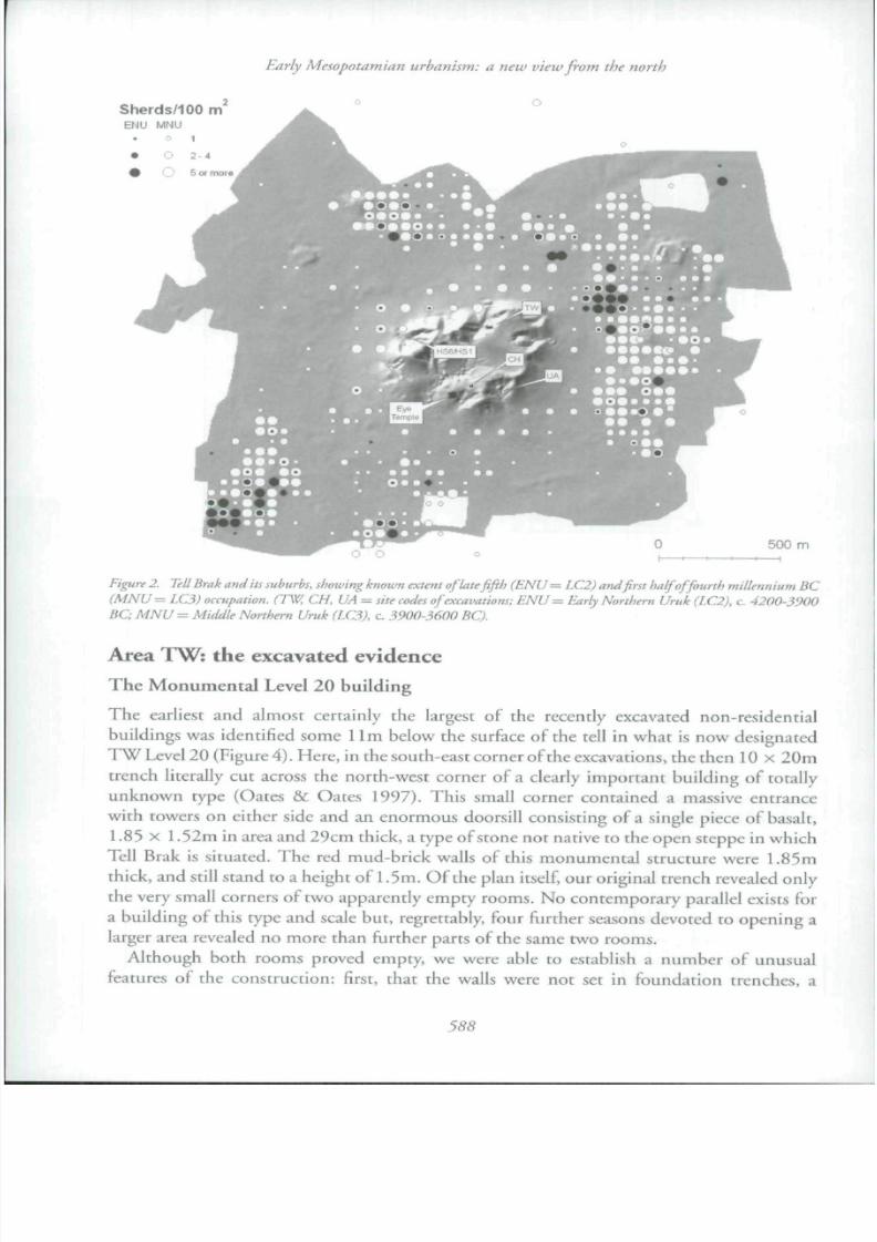
almost 300ha (Figure 2; see also Ur etal. in press). Unfortunately much ofthis area has
been heavily destroyed by extensive quarry pits from which soil was extracted for ancient
building purposes, by ancient and modern ploughing (Wilkinson etal. 2001) and by modern
construct ion.It was not our original intention to excavate fourth-millennium BC levels, recognising
that these would be buried beneath the great depth of the third-millennium city which our
excavations have now established as one of the largest urban centres in the north (D. Oates
etai. 2001). Reasonably accessible fourth-millennium levels have been identified, however,
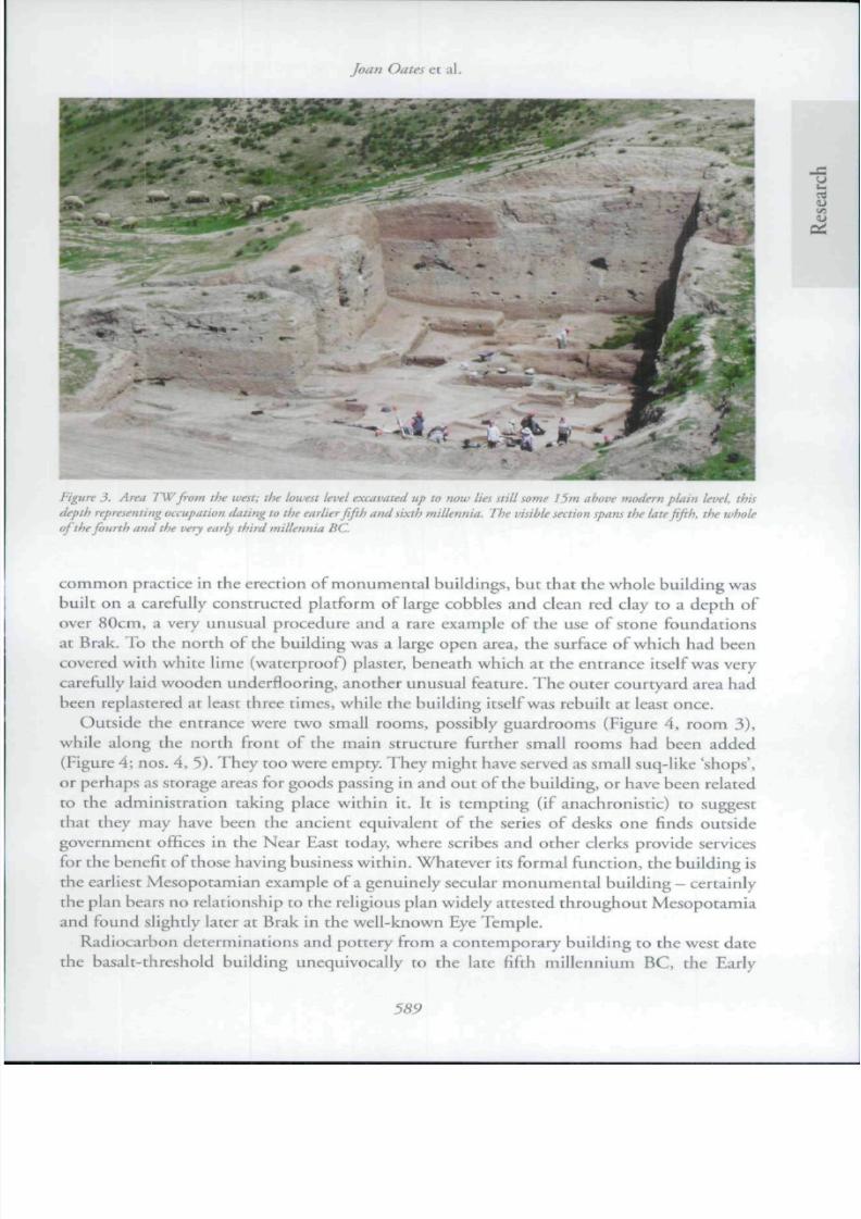
in several parts of the site. It is the most recent of these excavations in Area TW, near the
northern entrance to the ancient city, that forms the focus ofthis paper (Figure 3). Here
our work has revealed monumental structures associated with organised craft activity, the
manufacture of prestige goods, bureaucratic paraphernalia and evidence for the organisation
and provisionin g of labour b eyon d h ouse hold levels, all dating from the late fifi:h an d theearly fourth millennia BC. Reinforcing this impression is the contemporary evidence for
8/3/2019 Oats Et Al 2007 ian Urbanism
http://slidepdf.com/reader/full/oats-et-al-2007-ian-urbanism 4/17
8/3/2019 Oats Et Al 2007 ian Urbanism
http://slidepdf.com/reader/full/oats-et-al-2007-ian-urbanism 5/17
Figure 3. Area TWfrom the west; the lowest level excavated up to now lies still some i?»i diwir uionfi-n puim level, this
depth representing occupation dating to the earlier Jifth an d sixth millennia. The visihle section spans the late fifth, the whole
oJ the fourth and the very early third millennia B('.
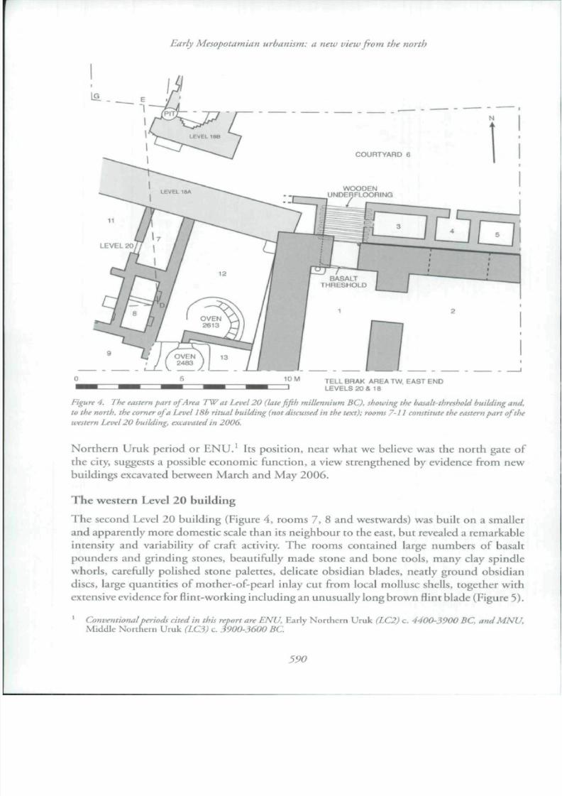
com mo n practice in the erection of mo num ental buildings, bu t that the whole building was
built on a carefully constructed platform of large cobbles and clean red clay to a depth of
over 80cm, a very unusual procedure and a rare example ofthe use of stone foundations
at Brak. To the north ofthe building was a large open area, the surface of which had been
covered with white lime (waterproof) plaster, beneath which at the entrance itself was very
carefully laid wooden underflooring, another unusual feature. The outer courtyard area had
been replastered at least three times, while the building itself was rebuilt at least once.
Outside the entrance were two small rooms, possibly guardrooms {Figure 4, room 3),while along the north front of the main structure further small rooms had been added
(Figure 4; nos. 4, 5 ). Th ey too were empty. Th ey mig ht have served as small suq-like 'shops',
or perhaps as storage areas for goods passing in and ou t o fth e build ing, or have been related
to the administration taking place within it. It is tempting (if anachronistic) to suggest
that they may have been the ancient equivalent of the series of desks one finds outside
government offices in the Near East today, where scribes and other clerks provide services
for the benefit of those having business within. Whatever its formal function, the building is
the earliest Mesopotamian example of a genuinely secular monumental building - certainly
che plan bears no relationship to the religious plan widely attested thro ug ho ut M esop otam iaand found slightly later at Brak in the well-known Eye Temple.
8/3/2019 Oats Et Al 2007 ian Urbanism
http://slidepdf.com/reader/full/oats-et-al-2007-ian-urbanism 6/17
8/3/2019 Oats Et Al 2007 ian Urbanism
http://slidepdf.com/reader/full/oats-et-al-2007-ian-urbanism 7/17
Joan Oates et al.
Several large ovens lay w ithin the room s of the build ing w hich w ere also furnished with
plastered basins and bins. O f especial interest was the large nu tnb er o f clay seal im pressions,
inclu din gd oo rsea ling s indicating'official' locking. T h e overall impression Is of an ' industrial '
build ing associated wich a possibly open w orkin g area to the n or th. A sherd-paved street ran
along its western .side in the direction of the north gate; the entrance itself, together with
the re.st of the building, lie unfortunately beneath the unexcavated area of the high tell to
the south.
The ' red i ibn bui ld ing ' (TW Leve l 19)
In Levels 19 and 18, two buildings overlay the western Level 20 building just described.
The Level 19 building, discovered in 2006 (Figure 6), had massive red mud-brick walls and
many ovens that were undoubtedly ' industrial ' . Three distinct floors were identified, with
much /// situ material, suggesting a relatively long period of use. Of particular interest wasthe tact that the pottery included both early versions ai M N U (LC3) types while other forms
were closer to the ENU (LC2) repertoire well-known from Tepe Gawra (Tobler 1950) and
T W Levels 20-22 and earlier at Tell Brak. T hu s the po ttery of Level 19 appears to represent
a phase transitional between Early Northern and Middle Northern Uruk. Among the new
types were very large open bowls, small bowls with incised craftsman's marks suggestive of
later pictographs (Figure 7) and a new type of mass-produced bowl, unlike the moulded
'wide Rower pots' characteristic of ENU levels.
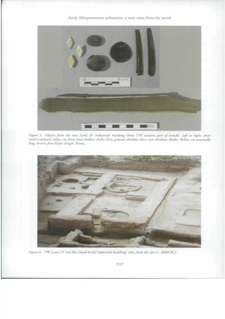
O th er finds consisted of very large quantities of raw m aterials, great piles of very beautiful
raw flint and obsidian, for example, together with both debitage and finely worked pieces,also a great variety of coloured stones (including jasper, marble, serpentine and various
diorites) used for the manufacture of beads, polished celts and other stone objects. Much
raw bitumen was also present, including a single large piece weighing just under 1kg. There
were large deposits of clay spindle w horls; these and the high percentag e of sheep/go at faunal
remains not only here but also in later fourth-millennium levels emphasise the importance
of wool and presumably weaving at the site. Also found were quantities of river molluscs
from which mother-of-pearl inlays were cut. With the exception of the latter, most of the
raw materials had been brought from considerable distances, and without the benefit of
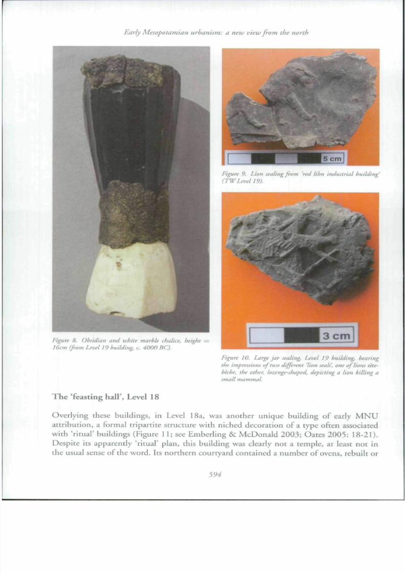
donk ey tra nsp ort for which th ere is as yet no evidence in the K hab ur region.The most extraordinary find was a unique, obsidian and white marhle 'chalice' (Figure 8).
The cup itself was made from a large obsidian core, the interior of which had been
ground out in order to form a deeply-hollowed drinking vessel; the base had also
been hollowed to provide a smooth cup-like depression in which the obsidian could
be inserted. The cwo stone pieces were held together by bitumen, both within che
hollowed base and encasing the two parts of the vessel as visible in the photograph. The
upper rim had been slightly ground and a narrow covering of bitumen added, within
which was a neat groove for the insertion of some other material, presumably something
valuable such as gold, since this had been removed before the vessel itself was placedin the bin in which it was found. The stark contrast between this vessel and the mass-
8/3/2019 Oats Et Al 2007 ian Urbanism
http://slidepdf.com/reader/full/oats-et-al-2007-ian-urbanism 8/17
Early Mesopotamian urhanism: a new view from the north
Figure 5. Objects from the new Level 20 'industrial building (Area TW , westem part of trench). Leji to right: three
mother-of-pearl inlays cut from local mollusc shells; three ground obsidian discs; two obsidian blades. Below: an unu
long, brow n Jiint blade (length 26cm).

8/3/2019 Oats Et Al 2007 ian Urbanism
http://slidepdf.com/reader/full/oats-et-al-2007-ian-urbanism 9/17
]oan Oates et al.
10cm
Figure 7. Small bowls from Level 19 building, a number of
which bore similar 'pictographs'.
chalice and, on the other, a great
number of crude, undecorated mass-
produced types. Such differences, involving
aesthetic standards exclusive to only a
small proportion ofthe population, suggest
increasing social stratification {Wengrow
2002) .
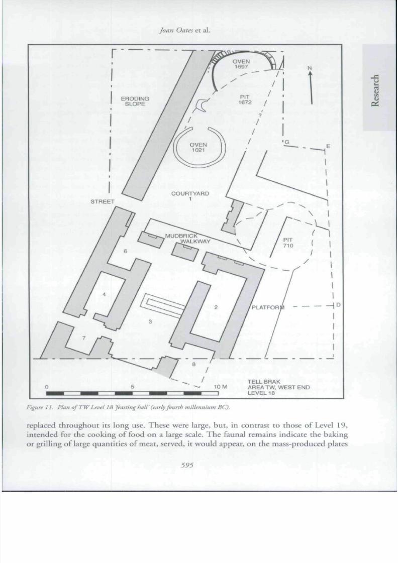
Among the most interesting finds
from these workshop rooms was a large
collection of stamp sealings, including
those illustrated in Figures 9 and 10. A pile
of over 50 'sling bullets' was found in the
corner ofthe N E roo m, having been stored
there in a sack or other perishable c onta iner
almost certainly as raw material for such
sealings (these 'sling bullets', at least, were
not 'warring weapons', as has recently been suggested). The concept of 'importance' is
implied also by the presence in the same building of a beautiful, indeed unusual, lion
stamp sealing, a motif rarely found on early seals and certainly, in later periods, a symbol
of'kingship' {Figure 9), suggesting that the building was controlled by or on behalf of a
very senior official. Perhaps even mote significant in this context is the presence of a seal
impression depicting a lion caught in a net {Figure 10). Not only is the ruler himself a lion,
metaphorically speaking, but greater than lions in being able to organise their capture, inlater periods a strictly royal prerogative.
The use of seals to signify ownership or control was in later periods a major facet of
south Mesopotamian administration, appearing at Uruk hand in hand with 'numerical
tablets' and the pictographic script {c , 340 0 B C). Yet this impo rtant administrative practice
had its origins in central and northern Mesopotamia as early as 7000 BC (Akkermans &
Duistermaat 1997; also Ferioli et al. 1994; Oates 1996) and by the Late 'Ubaid period
had becom e a well-developed practice on no rthe rn sites, unrepre sented in the south (e.g.
Tepe Gaw ra; and D egirm entepe in south-eastern Turkey, Esin 1994). By the end o ft h e
Hfth millennium the evidence suggests a complex hierarchy of authority at Brak, while atthe contemp orary, lh a site of Gaw ra, glyptic evidence suggests contrasting, residence-based
'cottage-industries' (Ro thm an 20 02) as oppo sed to Brak's mo re centralised pro du ctio n.
At Brak the majority of sealings from the recent excavations bear single stamp seal
impressions, often 2 or 3 impressions of the same seal if the surviving fragment is large
(they are always broken when found). There are also at least two instances of sealings
bearing impressions of more than one seal (Figure 10). Such double sealing suggests
either two distinct levels of administration or two equal but different types of official,
in either case evidence for substantial organisational complexity. Interestingly, the need
for signatures of more than one responsible official is a practice that persists still in theNear East today. Also from an N M U contex t at Brak are two small pictographic 'do ckets'
8/3/2019 Oats Et Al 2007 ian Urbanism
http://slidepdf.com/reader/full/oats-et-al-2007-ian-urbanism 10/17
Early Mesopotamian urbanism: a new view from the n orth
Figure 9. Lion sealing from 'red libn industrial buildin
(F W Level 19).
figure 8. Obsidian and white ma rhlf chalice, height =16cm (from Level 19 building, c. 4000 BC).
Figure 10. Large Ja r sealing. Level 19 building, bearing
the impressions of two different 'lion seals', on e of lions te
beche. the other, lozenge-shaped, depicting a lion killin
small mammal
The 'feasting hall'. Level 18
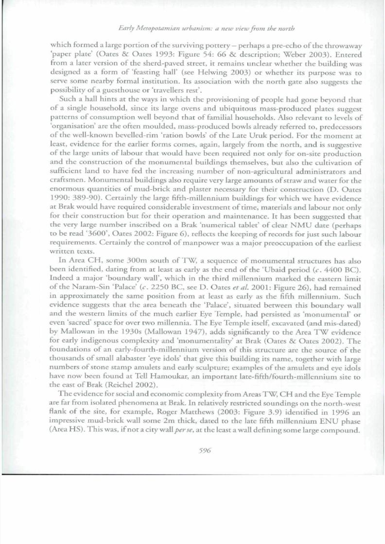
Overlying these buildings, in Level 18a, was another unique building of early MNU
attribution, a formal tripartite structure with niched decoration of a type often associatedwith 'ritual' buildings (Figure 11; see Emberling & McD onald 2003; Oates 20 05: 18-21).
8/3/2019 Oats Et Al 2007 ian Urbanism
http://slidepdf.com/reader/full/oats-et-al-2007-ian-urbanism 11/17
foan Oates et al.
| D
TELL BRAKAREATW, WEST ENDLEVEL 18
Figure IL Plan oJ' TW Le vel 18 feasting hall' (early fourth millennium BC).
replaced throughout its long use. These were large, but, in contrast to those of Level 19,
8/3/2019 Oats Et Al 2007 ian Urbanism
http://slidepdf.com/reader/full/oats-et-al-2007-ian-urbanism 12/17
T
Early Mesopotamian urbanism: a new view from the north
wh ich formed a large portion of the surviving pottery - pethap s a pre-echo of the throwaway
paper plate ' {Oates & Oates 1993; Figure 54: 66 & description; Weber 2003). Entered
from a later version of the sherd-paved street, it remains unclear whether the building was
designed as a form of 'feasting hall ' (see Helwing 2003) or whether its purpose was to
serve some nearby formal institution, its association with the north gate also suggests thepossibility ofa guesthouse or 'travellers rest' .
Such a hall hints at the ways in which the provisioning of people had gone beyond that
ofa single household, since its large ovens and ubiquitous mass-produced plates suggest
patterns of consumption well beyond that of familial households. Also relevant to levels of
'organisation' are the often moulded, mass-produced bowls already referred to, predecessors
of the well-known bevelled-rim 'ration bowls' of the Late Uruk period. For the moment at
least, evidence For the earlier forms comes, again, largely from the north, and is suggestive
of the large units of labour that would have been required not only for on-site production
and the construction of the monumental buildings themselves, but also the cultivation ofsufficient land to have fed the increasing number of non-agricultural administrators and
craftsmen. M on um enta l buildings also require very large am ou nts of straw and w ater for the
enormous quantities of mud-brick and plaster necessary for their construction (D. Oates
1990: 38 9- 90 ). Certain ly the large fifth-millennium building s For wh ich we have evidence
at Brak would have required considerable investment of time, materials and labour not only
for their construction but for their operation and maintenance. It has been suggested that
the very large num be r inscribed on a Brak 'num erical tablet' of clear N M U date (perhaps
to be read '3600', Oates 2002: Figure 6), reflects the keeping of records For just such labour
requirements. Certainly the control oFmanpower was a major preoccupation oFthe earliestwritten texts.
In Area C H , some 300 m south o FT W , a sequence oF m onu me ntal structures has also
been identified, dating from at least as early as the end of the 'Ubaid period (c. 4400 BC).
Indeed a major 'boundary wall ' , which in the third millennium marked the eastern limit
of the Naram-Sin 'Palace' {c . 2250 BC, see D. Oates etal. 2001: Figure 26), had remained
in approximately the same position from at least as early as the fifth millennium. Such
evidence suggests that the area beneath the 'Palace', situated between this boundary wall
and the western limits of the much earlier Eye Temple, had persisted as 'monumental ' or
even 'sacred' space for over two m illennia. T he Eye Tem ple itself, excavated (and mis-dated)by M allowan in the 1 930s (Mallow an 194 7), adds significantly to the Area T W evidence
for early indigenous complexity and 'monumentality' at Brak (Oates & Oates 2002). The
foundations of an early-Fourth-millennium version of this structure are the source of the
thousands oF small alabaster 'eye idols' that give this building its name, together with large
numbers of stone stamp amulets and early sculpture; examples of the amulets and eye idols
have now been found at Tell Ha m ouk ar, an imp ortan t late-fifth/fourth-millennium site to
the east of Brak (Reichel 2002).
T h e evidence for social and eco nom ic com plexity from Areas TW , C H and the Eye Tem ple
are far from isolated phenomena at Brak. In relatively restricted soundings on the north-westflank of the site, for example, Roger Matthews (2003 : Figure 3.9) identified in 1996 an

8/3/2019 Oats Et Al 2007 ian Urbanism
http://slidepdf.com/reader/full/oats-et-al-2007-ian-urbanism 13/17
Joan Oates et al.
Suburban Brak in the late fifth and early fourth millennia
Beyond the outer limits of the high tell itself lies its 'suburban' area, an extensive zone
of low-mounded and generally heavily ploughed settlement covering just under 300ha.
Intensive system atic sherd collection in this area has revealed shifting patt erns of set dem en t "from the sixth m illen nium thro ugh the Islamic perio ds. O f particu lar relevance to recent
km rth/fifth-m illennium excavation at Brak, and early Near Eastern urbanism in general,
are the outer town distribu tions of sherds of the EN U an d M N U periods (illustrated in
Figure 2). T he area of late-fifth-millennium EN U settleme nt on th e tell itself, as revealed by
the excavations up to now, covers a minimum of 30ha, while the suburban survey showed
isolated clusters oF settle m ent in the ou ter tow n, all at least 30 0m from the high m ou nd .
Each of seven clusters covered from 1.5 to 5ha. In total, ENU settlement occupied at least
50ha and probably more, given our conservative estimate of occupation on the high tell.
While most setdements of this date are small villages, Brak must be placed with the evenlarger, low-density, 300ha settled area at Khirbet al-Fakhar, the outer suburbs of Hamoukar
(Ur 2002). Although they are unUkely all to have been contemporaneous (Dewar 1991),
these spatially extensive northern Mesopotamian settlements are now forcing a reassessment
of the current Uru k-cen tric model oF urban origins (Ur et al. in press). Btak, Gawra and
Hamoukar are also closely linked in the production of virtually identical pottery over an
area of some 300km. This includes 'channel-rim' vessels which seem to have served some
'distilling' function and the presence of an 'elite' ceramic. For which there is prod uctio n
evidence in the form of kiln wasters at both Btak and Cawra. This very distinctive pottery
type occurs also in south-eastern Turkey (Oates & Oates 2004: 182).In the subsequent M N U period (r. 390 0-36 00 BC) the high mou nd at Tell Brak remained
fully settled while occupation in the outer town intensified. At the same time the outer,
isolated clusters of ENU settlement appear to have grown together to form larger and
more continuous areas of settlement. In addition to the high mound, these outer settled
zones covered at least lOOha, creating a minimum total settled area of over 130ha. Again,
these figures are conservative. The cluster immediately to the south of the high mound,
for example, probably extended north to the Eye Temple, but this area is now covered by
substantial remains of the third-millennium lower town together with eroded outwash from
Brak's central gully.
Sherds of the Late Uruk phase (3400-3200 BC), the period when the high tell at Brak
and a number of other northern settlements appear to have been colonised by southern
Mesopotamians, are found in low density around the lower town but cluster in particular
on a small rise south-west of the main mound and also to the south-east. It remains
difficult to establish certain contemporaneity between the local and intrusive southern
areas of settlement, but it might be tentatively proposed that these outer settlements were
me rchan ts' colonies ofa type similar to the O ld Assyrian kdrum which were also established
among large indigenous populations.
Conclusions
8/3/2019 Oats Et Al 2007 ian Urbanism
http://slidepdf.com/reader/full/oats-et-al-2007-ian-urbanism 14/17
Early Mesopotamian urbanism: a new viewjrom the north
Mesopotamian sites, however, reveals a level of nascent social and economic complexity
together with proto-urban growth up to 1000 years earlier. For the moment, Brak remains
un iqu e in three respects - the size of its fiFth- and early-Fourth-miliennia areas of settlem ent,
the range and types of contem porary 'public ' buildings and the accom panying, long sequence
of well-stratified archaeological materials from this most crucial period in the growth ofcomplex urban society, a phase that has recently been referred to as already representing a
'state-level' (Gibson & Maktash 2000: 477). As yet, no other large site, indeed no other
Near Eastern site, has yielded comparable evidence, though such may ultimately be found
at Hamoukar where the apparent spatial extent of the outer ENU setdement covers an
area even larger than that at Brak. This is not to argue that such developments will never
be discovered in southern Mesopotamia, only that there exists a wider picture, far more
complex than had previously been realised.
The discovery in 2006 of large workshops with an extraordinary array of non-local raw
materials prom ises Further evidence o f complex ity in earlier levels below. Certain ly we h aveyet to reach the earliest phases of such social and economic innovation. Indeed current
evidence suggests that the initial stimulus may originate in the underlying 'Ubaid period,
itself currently subject to 'notth-south' debate and, to judge from Area CH and out-of
contex t evidence, und ou bted ly w ell-rep resented at Brak. T he 20 06 results also help to m ake
sense of the unparalleled grave goods from an approximately contemporary cemetery at the
very small site of Tepe Gawra in north-eastern Iraq, which included gold studs and rosettes,
an electrum wolf's head and complete vessels oFground obsidian (Tobler 1930), symbols of
an elite that up to now has been ill-represented in the archaeological record. Unfortunately,
the Brak cemetery continues to elude us. Indeed the negative evidence of the intensive'suburban' survey suggests that it may lie well beyond the settlement boundary. In writing of
the development oFcomplex society in southern Mesopotamia Gil Stein (1994) emphasised
the importance of small scale, irrigation-based 'Ubaid polities using 'inclusive ideologie
empha sizing ^oup mem bership through a strategy ofritually mobilized staple finance'. This is
in contrast with areas where 'wealth distribution', not so far visible in the southern evidence
played a crucial role. Our work at Brak suggests a complex combination of both strategies.
The location of Brak within later Assyria's most dependable 'granary' and a wool-rich
steppe, together with the 2006 evidence for accumulation of'status raw materials ' and the
unique 'chalice' itself, suggest that developing complexity in the north involved both 'staplefinance', thou gh here not apparen tly 'ritually' mobilised, together with a considerable degree
ot 'wealth distribution' seen in the elite grave goods at Gawra and in their 'institutional'
manufacture at Brak.
We must admit to some diFficulty in defining more precisely our use of the term 'urban'.
Certainly definitions of urbanism that remain applicable cross-culturally present problems.
Gh ilde's 1950$ list remains influential desp ite the m an y cases wh ich seem differentiated in
som e way from those arou nd them bu t which fail in some or all of Childe's categories. Recent
wo rk seems to accept urban ism as a mo re Fuzzy conc ept, characterised by a cluster of variables
tha t are best considered along axes of degree rather than simple presence or absence. W h at isclear from ou r evidence is the differentiation o fa site like Brak from those in its hinter lan d

8/3/2019 Oats Et Al 2007 ian Urbanism
http://slidepdf.com/reader/full/oats-et-al-2007-ian-urbanism 15/17
8/3/2019 Oats Et Al 2007 ian Urbanism
http://slidepdf.com/reader/full/oats-et-al-2007-ian-urbanism 16/17

8/3/2019 Oats Et Al 2007 ian Urbanism
http://slidepdf.com/reader/full/oats-et-al-2007-ian-urbanism 17/17