Embed Size (px)
Citation preview
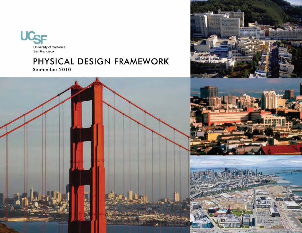
PHYSICAL DESIGN FRAMEWORK
University of CaliforniaSan Francisco
September 2010

September 2010PHYSICAL DESIGN FRAMEWORKUniversity of California, San Francisco

TABLE OF CONTENTS
1
2
3
4
5
1 | BackgroundPurpose of this Physical Design Framework � � � � � � � � � � � � � � � � � � � � � � � 1 �1Mission and Vision � � � � � � � � � � � � � � � � � � � � � � � � � � � � � � � � � � � � � � � � � � � � � � � � � � � � � 1 �2Content � � � � � � � � � � � � � � � � � � � � � � � � � � � � � � � � � � � � � � � � � � � � � � � � � � � � � � � � � � � � � � � � � � � 1 �3Related Plans � � � � � � � � � � � � � � � � � � � � � � � � � � � � � � � � � � � � � � � � � � � � � � � � � � � � � � � � � � � � � 1 �3Space and Population Growth � � � � � � � � � � � � � � � � � � � � � � � � � � � � � � � � � � � � � � � � 1 �4Historical Context � � � � � � � � � � � � � � � � � � � � � � � � � � � � � � � � � � � � � � � � � � � � � � � � � � � � � � 1 �6Campus Character � � � � � � � � � � � � � � � � � � � � � � � � � � � � � � � � � � � � � � � � � � � � � � � � � � � � � � 1 �7
2 | Universal Planning & Design Principles
Respond to CONTEXT while Reinforcing Identity � � � � � � � � � � � � � � 2 �2Welcome the COMMUNITY � � � � � � � � � � � � � � � � � � � � � � � � � � � � � � � � � � � � � � � � � 2 �6Ensure CONNECTIVITY to and Within the Campus � � � � � � � � � � � 2 �8Improve Campus COHESIVENESS � � � � � � � � � � � � � � � � � � � � � � � � � � � � � � � � 2 �10Create Spaces to Promote COLLEGIALITY � � � � � � � � � � � � � � � � � � � � � � 2 �12Lead Through CONSERVATION and Sustainability � � � � � � � � � � � � 2 �14
3 | Planning & Design Framework
Parnassus Heights � � � � � � � � � � � � � � � � � � � � � � � � � � � � � � � � � � � � � � � � � � � � � � � � � � � � � � � 3 �2Mission Bay � � � � � � � � � � � � � � � � � � � � � � � � � � � � � � � � � � � � � � � � � � � � � � � � � � � � � � � � � � � � � 3 �24
4 | Campus Systems
Transportation � � � � � � � � � � � � � � � � � � � � � � � � � � � � � � � � � � � � � � � � � � � � � � � � � � � � � � � � 4 �1Utilities � � � � � � � � � � � � � � � � � � � � � � � � � � � � � � � � � � � � � � � � � � � � � � � � � � � � � � � � � � � � � � � � � 4 �4
5 | Physical Planning and Design Process
Related Documents
Mission Bay Campus Master Plan and Design Guidelineshttp://campusplanning.ucsf.edu/physical/missionbayplan.php
Preliminary Parnassus Heights Design Goals and Guidelineshttp://campusplanning.ucsf.edu/pdf/DraftPHtsDesignGoalsGuidelines.pdf
1.1
1 | Background
PuRPOSE OF THIS PHYSICAL DESIGN FRAMEWORK
This Physical Design Framework sets forth a vision for the physical development of UCSF campus sites through-out the City of San Francisco consistent with its mission of “Advancing Health Worldwide.” It will serve as the foundation for UCSF to plan and design future projects according to a clear and consistent set of planning and design principles, guidelines and strategies. Along with the Mission Bay Campus Master Plan and Design Guide-lines, the Preliminary Parnassus Heights Design Goals and Guidelines, and Facilities Design Guidelines, the Physical Design Framework will also provide guidance for design consultants retained by UCSF to ensure that future proj-ects enhance the physical environment and will enable UCSF to determine if those designs are consistent with these principles, guidelines and strategies.
Together with the accompanying Capital Financial Plan, the Physical Design Framework also provides the basis for eligibility for UCSF to participate in the pilot phase of the delegated project approval process. These documents will inform The Regents as to the University’s capital investment strategy and physical design approach, and once approved, conforming projects may be approved by the Chancellor with Office of the President review.
1.2 PHYSICAL DESIGN FRAMEWORK
MISSION AND VISION
UCSF is one of the nation’s preeminent health-science institutions, with a four-fold mission: teaching, research, patient care, and community service.
In 2007, UCSF developed a Strategic Plan to serve as a guide in implementing the overall mission of “AdvancingHealth Worldwide.” �e Strategic Plan provides a vision committing UCSF to the following goals:
Fostering Innovation and Collaboration •
In meeting these goals, the Strategic Plan gives priority to building new specialty hospitals and renovating existing ones; developing a new teaching and learning center and clinical and translational research institute; and improving the quality of campus information technology systems,utility infrastructure and seismic life-safety conditions.
�e Strategic Plan goals and priorities will serve as the foundation for the next LRDP, which UCSF expects to complete within the next few years.
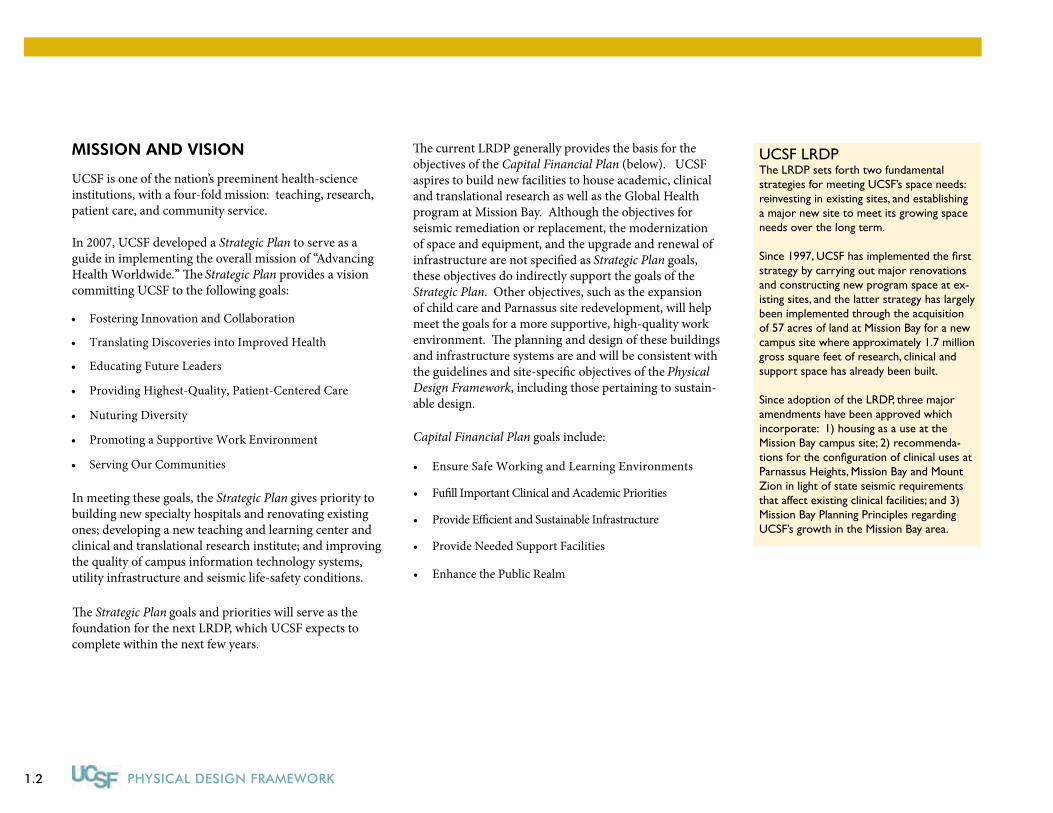
UCSF LRDPThe LRDP sets forth two fundamental strategies for meeting UCSF’s space needs: reinvesting in existing sites, and establishing a major new site to meet its growing space needs over the long term.
Since 1997, UCSF has implemented the first strategy by carrying out major renovations and constructing new program space at ex-isting sites, and the latter strategy has largely been implemented through the acquisition of 57 acres of land at Mission Bay for a new campus site where approximately 1.7 million gross square feet of research, clinical and support space has already been built.
Since adoption of the LRDP, three major amendments have been approved which incorporate: 1) housing as a use at the Mission Bay campus site; 2) recommenda-tions for the configuration of clinical uses at Parnassus Heights, Mission Bay and Mount Zion in light of state seismic requirements that affect existing clinical facilities; and 3) Mission Bay Planning Principles regarding UCSF’s growth in the Mission Bay area.
�e current LRDP generally provides the basis for the objectives of the Capital Financial Plan (below). UCSF aspires to build new facilities to house academic, clinical and translational research as well as the Global Health program at Mission Bay. Although the objectives for seismic remediation or replacement, the modernization of space and equipment, and the upgrade and renewal ofinfrastructure are not speci�ed as Strategic Plan goals, these objectives do indirectly support the goals of the Strategic Plan. Other objectives, such as the expansion of child care and Parnassus site redevelopment, will help meet the goals for a more supportive, high-quality workenvironment. �e planning and design of these buildings and infrastructure systems are and will be consistent withthe guidelines and site-speci�c objectives of the Physical Design Framework, including those pertaining to sustain-able design.
Capital Financial Plan goals include:
Ensure Safe Working and Learning Environments•
Fu�ll Important Clinical and Academic Priorities•
Provide E�cient and Sustainable Infrastructure •
Provide Needed Support Facilities •
Translating Discoveries into Improved Health•
Educating Future Leaders •
Providing Highest-Quality, Patient-Centered Care •
Nuturing Diversity •
Promoting a Supportive Work Environment •
Serving Our Communities •
Enhance the Public Realm •
1.3
BACKGROUND
CONTENT
�is Physical Design Framework is organized to addressthe particular issues associated with a multi-site cam-pus in an urban environment. Among UC campuses, UCSF is unique in that it has multiple urban sites spread throughout a large geographic area of a city. UCSF oc-cupies three major sites at Parnassus Heights, Mission Bay and Mount Zion, plus several smaller sites including Laurel Heights, the Mission Center Building, the Minne-sota Street Building and Buchanan Dental Clinic. UCSF also occupies space at San Francisco General Hospital and over two dozen leased sites throughout the city.
All of UCSF’s locations are a part of the urban fabric of the neighborhoods they are located in, and have public streets surrounding, adjoining and in some cases running through them.
For these reasons, this Physical Design Framework con-tains planning and design principles and guidelines that are universally applicable to all of these campus sites. To amplify these universal design principles and guidelines,site-speci�c implementation strategies and guidelinesthat �ow from these universal principles are included as examples for the Parnassus Heights and Mission Bay sites.
RELATED PLANS
�e LRDP is the primary driver of the physical developmentfor UCSF. �e LRDP articulates a long-term vision of creating integrated programs with clinical care at all three major sites; inpatient care, basic sciences, clinical and translational research, and graduate academic programs at Parnassus Heights and Mission Bay; and major outpa-tient services and research at Mount Zion. UCSF expects to begin a comprehensive process to update the LRDPin 2010 so that a new LRDP may be adopted by �e Regents towards the end of the current LRDP’s planninghorizon of approximately 15 years. A�er the new LRDP is adopted, the Physical Design Framework is expected to be revisited and revised as appropriate. �e Capital Financial Plan will be updated annually, starting before the next LRDP is completed.
In the meantime, UCSF has embarked on preliminary planning studies of several campus sites that will providethe foundation for the new LRDP. �ese include the Preliminary Parnassus Heights Design Goals and Guide-
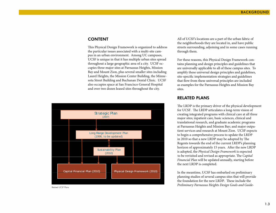
UCSF PLANS
Strategic Plan (2007)
Long Range Development Plan (1996, to be updated)
Sustainability Plan (2010)
Physical Design Framework (2010)Capital Financial Plan (2010)
3
y g ( )p ( )
Related UCSF Plans
1.4 PHYSICAL DESIGN FRAMEWORK
lines, which articulates standards for the development of buildings and open space at that site. In addition, UCSF is in the process of studying the Mission Bay site with the Second Phase Study, which will explore opportunities to improve the Mission Bay Campus Master Plan and Design Guidelines.
SPACE AND POPuLATION GROWTH
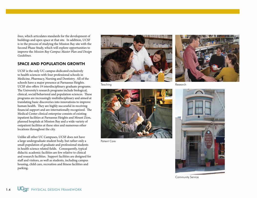
UCSF is the only UC campus dedicated exclusively to health sciences with four professional schools in Medicine, Pharmacy, Nursing and Dentistry. All of the schools have a major presence at Parnassus Heights. UCSF also offers 19 interdisciplinary graduate programs. The University’s research programs include biological, clinical, social/behavioral and population sciences. These programs are increasingly multidisciplinary and aimed at translating basic discoveries into innovations to improve human health. They are highly successful in receiving financial support and are internationally recognized. The Medical Center clinical enterprise consists of existing inpatient facilities at Parnassus Heights and Mount Zion, planned hospitals at Mission Bay and a wide variety of outpatient facilities at these sites and numerous other locations throughout the city.
Unlike all other UC Campuses, UCSF does not have a large undergraduate student body, but rather only a small population of graduate and professional students in health science related fields. Consequently, typical didactic academic facilities are few relative to clinical and research facilities. Support facilities are designed for staff and visitors, as well as students, including campus housing, child care, recreation and fitness facilities and parking.
Community Service
Research
Patient Care
Teaching
1.5
BACKGROUND
Enrollment at UCSF varies little from year to year. UCSF’s student enrollment (excluding medical residents and postdoctoral scholars) is currently approximately 3,000 in the 2009-10 academic year, and is projected to grow only modestly by approximately another 125 stu-dents in the 2015-16 academic year.
UCSF’s total average daily population including students, faculty, staff, patients and visitors at all sites was esti-
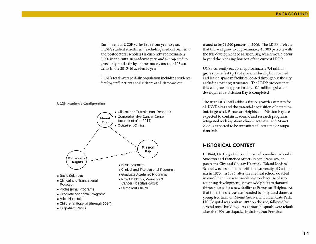
UCSF Academic Configuration
MountZion
MissionBay
ParnassusHeights
Clinical and Translational Research Comprehensive Cancer Center (outpatient after 2014) Outpatient Clinics
Basic Sciences Clinical and Translational Research Graduate Academic Programs New Children’s, Women’s & Cancer Hospitals (2014) Outpatient Clinics
Basic Sciences Clinical and Translational Research Professional Programs Graduate Academic Programs Adult Hospital Children’s Hospital (through 2014) Outpatient Clinics
mated to be 29,500 persons in 2006. The LRDP projects that this will grow to approximately 41,300 persons with the full development of Mission Bay, which would occur beyond the planning horizon of the current LRDP.
UCSF currently occupies approximately 7.4 million gross square feet (gsf) of space, including both owned and leased space in facilities located throughout the city, excluding parking structures. The LRDP projects that this will grow to approximately 10.1 million gsf when development at Mission Bay is completed.
The next LRDP will address future growth estimates for all UCSF sites and the potential acquisition of new sites, but, in general, Parnassus Heights and Mission Bay are expected to contain academic and research programs integrated with inpatient clinical activities and Mount Zion is expected to be transformed into a major outpa-tient hub.
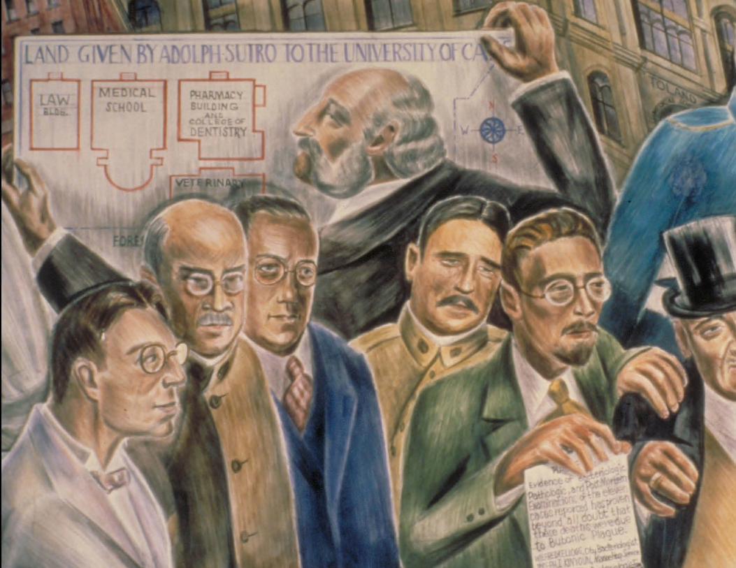
HISTORICAL CONTExT
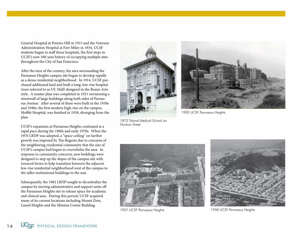
In 1864, Dr. Hugh H. Toland opened a medical school at Stockton and Francisco Streets in San Francisco, op-posite the City and County Hospital. Toland Medical School was first affiliated with the University of Califor-nia in 1873. In 1895, after the medical school doubled in enrollment but was unable to grow because of sur-rounding development, Mayor Adolph Sutro donated thirteen acres for a new facility at Parnassus Heights. At that time, the site was surrounded by only sand dunes, a young tree farm on Mount Sutro and Golden Gate Park. UC Hospital was built in 1897 on the site, followed by several more buildings. As various hospitals were rebuilt after the 1906 earthquake, including San Francisco
1.6 PHYSICAL DESIGN FRAMEWORK
1873 Toland Medical School on Stockon Street
1900 UCSF Parnassus Heights
1937 UCSF Parnassus Heights 1958 UCSF Parnassus Heights
General Hospital at Potrero Hill in 1915 and the Veterans Administration Hospital at Fort Miley in 1934, UCSF students began to staff those hospitals, the first steps in UCSF’s now 100-year history of occupying multiple sites throughout the City of San Francisco.
After the turn of the century, the area surrounding the Parnassus Heights campus site began to develop rapidly as a dense residential neighborhood. In 1914, UCSF pur-chased additional land and built a long, low-rise hospital (now referred to as UC Hall) designed in the Beaux-Arts style. A master plan was completed in 1921 envisioning a streetwall of large buildings along both sides of Parnas-sus Avenue. After several of these were built in the 1930s and 1940s, the first modern high-rise on the campus, Moffitt Hospital, was finished in 1958, diverging from the plan.
UCSF’s expansion at Parnassus Heights continued at a rapid pace during the 1960s and early 1970s. When the 1976 LRDP was adopted, a “space ceiling” on further growth was imposed by The Regents due to concerns of the neighboring residential community that the size of UCSF’s campus had begun to overwhelm the area. In response to community concerns, new buildings were designed to step up the slopes of the campus site with terraced forms to help transition between the adjacent low-rise residential neighborhood west of the campus to the taller institutional buildings to the east.
Subsequently, the 1982 LRDP sought to decentralize the campus by moving administrative and support units off the Parnassus Heights site to release space for academic and clinical uses. During this period, UCSF acquired many of its current locations including Mount Zion, Laurel Heights and the Mission Center Building.
1.7
BACKGROUND
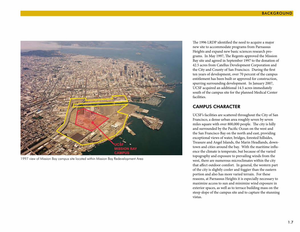
1997 view of Mission Bay campus site located within Mission Bay Redevelopment Area
The 1996 LRDP identified the need to acquire a major new site to accommodate programs from Parnassus Heights and expand new basic sciences research pro-grams. In May 1997, The Regents approved the Mission Bay site and agreed in September 1997 to the donation of 42.5 acres from Catellus Development Corporation and the City and County of San Francisco. During the first ten years of development, over 70 percent of the campus entitlement has been built or approved for construction, spurring surrounding development. In January 2007, UCSF acquired an additional 14.5 acres immediately south of the campus site for the planned Medical Center facilities.
CAMPuS CHARACTER
UCSF’s facilities are scattered throughout the City of San Francisco, a dense urban area roughly seven by seven miles square with over 800,000 people. The city is hilly and surrounded by the Pacific Ocean on the west and the San Francisco Bay on the north and east, providing exceptional views of water, bridges, forested hillsides, Treasure and Angel Islands, the Marin Headlands, down-town and cities around the bay. With the maritime influ-ence the climate is temperate, but because of the varied topography and exposure to prevailing winds from the west, there are numerous microclimates within the city that affect outdoor comfort. In general, the western part of the city is slightly cooler and foggier than the eastern portion and also has more varied terrain. For these reasons, at Parnassus Heights it is especially necessary to maximize access to sun and minimize wind exposure in exterior spaces, as well as to terrace building mass on the steep slope of the campus site and to capture the stunning vistas.
1.8 PHYSICAL DESIGN FRAMEWORK
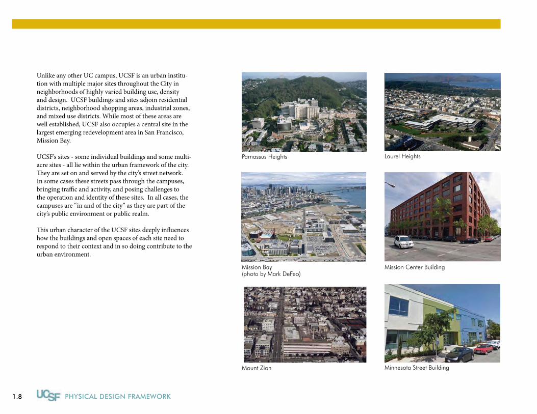
Unlike any other UC campus, UCSF is an urban institu-tion with multiple major sites throughout the City in neighborhoods of highly varied building use, density and design. UCSF buildings and sites adjoin residential districts, neighborhood shopping areas, industrial zones, and mixed use districts. While most of these areas are well established, UCSF also occupies a central site in the largest emerging redevelopment area in San Francisco, Mission Bay.
UCSF’s sites - some individual buildings and some multi-acre sites - all lie within the urban framework of the city. They are set on and served by the city’s street network. In some cases these streets pass through the campuses, bringing traffic and activity, and posing challenges to the operation and identity of these sites. In all cases, the campuses are “in and of the city” as they are part of the city’s public environment or public realm.
This urban character of the UCSF sites deeply influences how the buildings and open spaces of each site need to respond to their context and in so doing contribute to the urban environment.
Mission Bay (photo by Mark DeFeo)
Minnesota Street Building
Mission Center Building
Laurel HeightsParnassus Heights
Mount Zion
1.9
BACKGROUND
UCSF Sites
Hwy280
Hwy101
Hwy1
Hwy280
Hwy101
Hwy101
Hwy80
Hwy1
Hwy1
Hwy80
t
N
1 mile1 km
00
Golden Gate Bridge
SanFranciscoOaklandBayBridge
SanFrancisco Bay
GoldenGate Park
LincolnPark
Presidio
Lombard
Broadway
California
Sutter
Turk
Fulton
GearyEuclid
Judah
Noriega
Taraval
Sloat Ocean
Argu
ello
Scott
Laguna
Webster
Van Ness
Gough
Taylor
Kearny
Columbus
Embarcadero
19th
Ave
Suns
et
Grea
t High
way
North PointBay
Montgomery
Duboce
Lincoln
Monterey
FellOakMasonic
Stanyan
Clayton
PostO’Farrell
Lake
ClementGearyAnzaBalboa
Fulton
Irving
24th St
Cesar Chavez
evA dn24
ev A ht 03
ev A ht 52
Market
Mission
Folsom
Harriso
n King
Berry
Potrero
Dolores
Castro
Douglass
Kirkham
2nd St3rd St
3rd St 16th StMariposa
Minnesota
Miss
ion
BuchananOctavia
CarlParnassus
20th St
CargoEvans Oakdale
Palou
Griffith Crisp Spear Ave
Divisadero
FolsomHarrison
Presidio
Laurel
6th St
Guerrero
Phelp
s WilliamsVan Dyke
SF City/County Line
arreS orepinuJ
Jenn
ings
City of South San Francisco/ San Mateo County Line
Hillside
Westmoor
PacificOcean
Daly Boulevard
Bayshore
Lincoln Blvd
evA dr34
Claredon
Ocean Persia
Geneva
M anse ll
San Jose
Jam es own
Guadalupe Canyon
Paul
Font Blvd
John Muir Drive
1 Parnassus Heights
2 Mission Bay
3 Mount Zion
4 Laurel Heights
5. Buchanan Dental Clinic
6 Mission Center Building
7 Minnesota Street Building
8 Hunters Point Facility
9 San Francisco General Hospital (Affiliation)
10 Veterans Affairs Medical Center (Affilliation)
104
5
3
1 7
2
9
6
8
1.10 PHYSICAL DESIGN FRAMEWORK
2.1
Despite considerable diversity in the character and context of UCSF’s campus sites, six planning principles are universally applicable to UCSF’s sites, as they are all urban campuses “in and of the city” with common plan-ning and design objectives.
The six universal planning and design principles have been established to guide physical development at all owned UCSF campus sites. They express key thematic concepts that will be implemented, extended or rein-forced as the campus sites are further developed.
Four of the planning and design principles - Context, Connectivity, Cohesiveness and Collegiality - were developed as the Principal Conceptual Goals of the Mis-sion Bay Campus Master Plan and Design Guidelines and have long served as fundamental touchstones of UCSF’s development there, and are now consciously articulated as being universally applicable to UCSF’s other sites. Two additional principles - Community and Conservation - have been added to supplement the original four princi-pals, and are also universally applicable.
The recent design of the Medical Center facilities and Cardiovascular Research Building at Mission Bay have greatly influenced the design guidelines that follow. Both of these buildings have taken the Mission Bay Campus
2 | Universal Planning & Design Principles
Planning and Design Principles
Respond to CONTEXT while Reinforcing Identity •
Welcome the COMMUNITY •
Ensure CONNECTIVITY to and Within the Campus •
Improve Campus COHESIVENESS •
Create Spaces to Promote COLLEGIALITY •
Lead Through CONSERVATION and Sustainability•
Master Plan and Design Guidelines to a higher level of design and are considered by UCSF to be exemplary architectural models.
2.2 PHYSICAL DESIGN FRAMEWORK
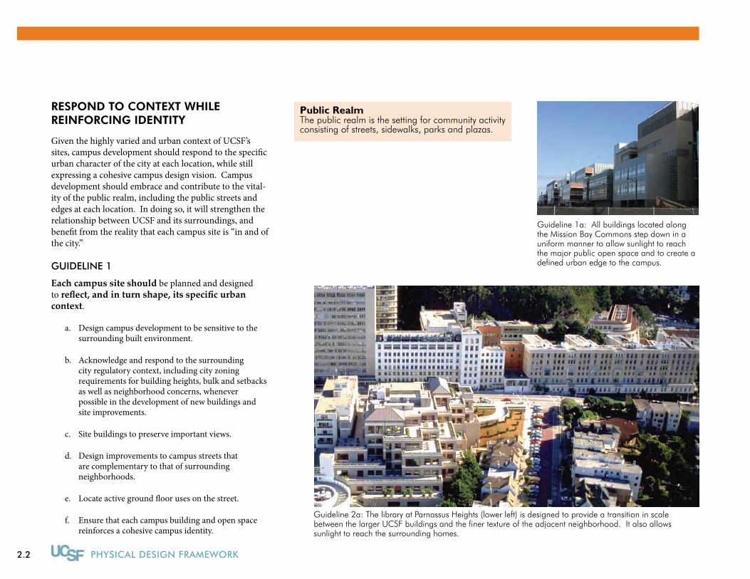
RESPOND TO CONTExT WHILE REINFORCING IDENTITY
Given the highly varied and urban context of UCSF’s sites, campus development should respond to the specific urban character of the city at each location, while still expressing a cohesive campus design vision. Campus development should embrace and contribute to the vital-ity of the public realm, including the public streets and edges at each location. In doing so, it will strengthen the relationship between UCSF and its surroundings, and benefit from the reality that each campus site is “in and of the city.”
GUIDELINE 1
Each campus site should be planned and designed to reflect, and in turn shape, its specific urban context.
Design campus development to be sensitive to the a. surrounding built environment.
Acknowledge and respond to the surrounding b. city regulatory context, including city zoning requirements for building heights, bulk and setbacks as well as neighborhood concerns, whenever possible in the development of new buildings and site improvements.
Site buildings to preserve important views.c.
Design improvements to campus streets that d. are complementary to that of surrounding neighborhoods.
Locate active ground floor uses on the street.e.
Ensure that each campus building and open space f. reinforces a cohesive campus identity.
Guideline 1a: All buildings located along the Mission Bay Commons step down in a uniform manner to allow sunlight to reach the major public open space and to create a defined urban edge to the campus.
Guideline 2a: The library at Parnassus Heights (lower left) is designed to provide a transition in scale between the larger UCSF buildings and the finer texture of the adjacent neighborhood. It also allows sunlight to reach the surrounding homes.
Public RealmThe public realm is the setting for community activity consisting of streets, sidewalks, parks and plazas.
2.3
UNIVERSAL PLANNING & DESIGN PRINCIPLES
Denote entries to core areas of campus through g. appropriate gateways.
GUIDELINE 2
Due to the highly urban context of UCSF’s sites, attention should be given to the edges where the campus meets the city, including the perimeter of each campus site as a whole, as well as the edges of the public streets that run through or alongside of each site. Because UCSF’s sites meet the city in a variety of edge conditions, both active and inactive, and including edges characterized by resi-dential, commercial, light industrial, mixed use and open space uses, campus edges should respond to their specific urban context.
Bridge campus development and the surrounding a. city through a transition of building height, massing and use and public open spaces.
Create a positive institutional identity and contribute b. to the public realm through the use of consistent and memorable signage, artwork, street furniture, paving, and landscaping.
Develop appropriate architectural expression at c. gateways to campus core areas.
Locate active interior public uses, amenities and d. services such as visitor centers, clinics, retail space, food service, fitness facilities, child care and auditoriums at edges to help activate the streets, and to encourage social interaction.
Treat major campus crossings of public streets that e. bisect campus sites to denote their importance as a place for campus interaction and interface with the city.
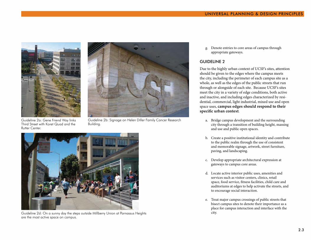
Guideline 2a: Gene Friend Way links Third Street with Koret Quad and the Rutter Center.
Guideline 2b: Signage on Helen Diller Family Cancer Research Building.
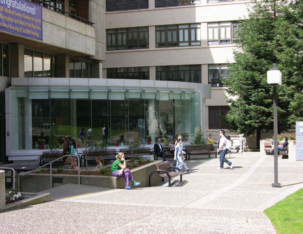
Guideline 2d: On a sunny day the steps outside Millberry Union at Parnassus Heights are the most active space on campus.
2.4 PHYSICAL DESIGN FRAMEWORK
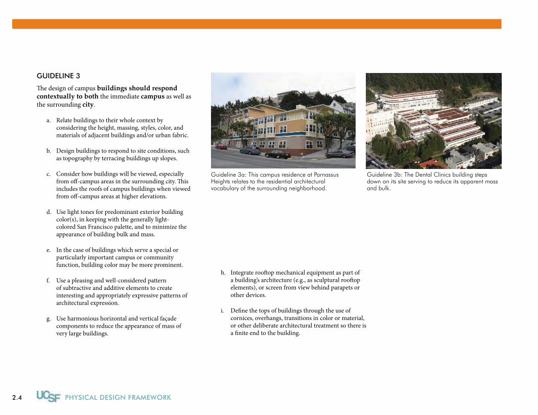
GUIDELINE 3
The design of campus buildings should respond contextually to both the immediate campus as well as the surrounding city.
Relate buildings to their whole context by a. considering the height, massing, styles, color, and materials of adjacent buildings and/or urban fabric.
Design buildings to respond to site conditions, such b. as topography by terracing buildings up slopes.
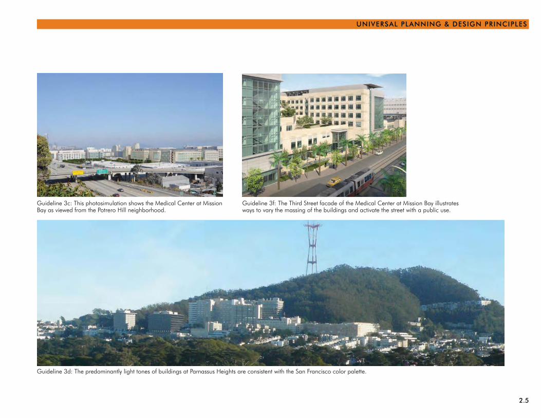
Consider how buildings will be viewed, especially c. from off-campus areas in the surrounding city. This includes the roofs of campus buildings when viewed from off-campus areas at higher elevations.
Use light tones for predominant exterior building d. color(s), in keeping with the generally light-colored San Francisco palette, and to minimize the appearance of building bulk and mass.
In the case of buildings which serve a special or e. particularly important campus or community function, building color may be more prominent.
Use a pleasing and well-considered pattern f. of subtractive and additive elements to create interesting and appropriately expressive patterns of architectural expression.
Use harmonious horizontal and vertical façade g. components to reduce the appearance of mass of very large buildings.
Guideline 3b: The Dental Clinics building steps down on its site serving to reduce its apparent mass and bulk.
Guideline 3a: This campus residence at Parnassus Heights relates to the residential architectural vocabulary of the surrounding neighborhood.
Integrate rooftop mechanical equipment as part of h. a building’s architecture (e.g., as sculptural rooftop elements), or screen from view behind parapets or other devices.
Define the tops of buildings through the use of i. cornices, overhangs, transitions in color or material, or other deliberate architectural treatment so there is a finite end to the building.
2.5
UNIVERSAL PLANNING & DESIGN PRINCIPLES
Guideline 3c: This photosimulation shows the Medical Center at Mission Bay as viewed from the Potrero Hill neighborhood.
Guideline 3d: The predominantly light tones of buildings at Parnassus Heights are consistent with the San Francisco color palette.
Guideline 3f: The Third Street facade of the Medical Center at Mission Bay illustrates ways to vary the massing of the buildings and activate the street with a public use.
2.6 PHYSICAL DESIGN FRAMEWORK
WELCOME THE COMMuNITY
It is UCSF’s intent to be inviting and accessible to its “community:” the academic community at each campus site (including students, faculty and staff), the collective UCSF community across all campus sites, the neighbors around each site, and the patients and visitors to UCSF’s clinical facilities.
At the interface between campus and the City, UCSF is dedicated to ensuring pedestrian safety, creating more enjoyable places where people want to congregate, treating the periphery of the campus as a “front door,” providing clear wayfinding for visitors, and working with the City to promote the San Francisco Better Streets Program.
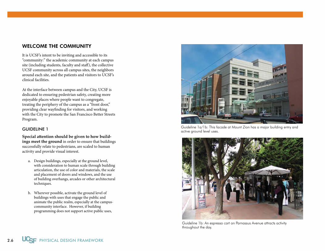
GUIDELINE 1
Special attention should be given to how build-ings meet the ground in order to ensure that buildings successfully relate to pedestrians, are scaled to human activity and provide visual interest.
Design buildings, especially at the ground level, a. with consideration to human scale through building articulation, the use of color and materials, the scale and placement of doors and windows, and the use of building overhangs, arcades or other architectural techniques.
Wherever possible, activate the ground level of b. buildings with uses that engage the public and animate the public realm, especially at the campus-community interface. However, if building programming does not support active public uses,
Guideline 1a/1b: This facade at Mount Zion has a major building entry and active ground level uses.
Guideline 1b: An espresso cart on Parnassus Avenue attracts activity throughout the day.
2.7
UNIVERSAL PLANNING & DESIGN PRINCIPLES
transparency to interior offices or circulation spaces at the ground level is preferable to blank walls.
Design building bases along pedestrian corridors c. to be welcoming and provide a clear visual path to desired destinations.
Clearly articulate building entrances with arcades, d. canopies, clear glazing, large doors, entry stoops, vestibules or other architectural features.
Provide exterior lighting that will create a sense of e. safety and encourage pedestrian activity while being sensitive to potential visual impacts on surrounding neighborhoods.
Locate loading docks and ground level service bays f. to be minimally visible but accessible by appropriate vehicles, and screen them as much as possible.
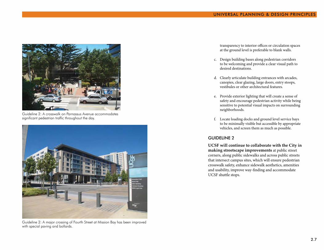
GUIDELINE 2
UCSF will continue to collaborate with the City in making streetscape improvements at public street corners, along public sidewalks and across public streets that intersect campus sites, which will ensure pedestrian crosswalk safety, enhance sidewalk aesthetics, amenities and usability, improve way-finding and accommodate UCSF shuttle stops.
Guideline 2: A major crossing of Fourth Street at Mission Bay has been improved with special paving and bollards.
Guideline 2: A crosswalk on Parnassus Avenue accommodates significant pedestrian traffic throughout the day.
2.8 PHYSICAL DESIGN FRAMEWORK
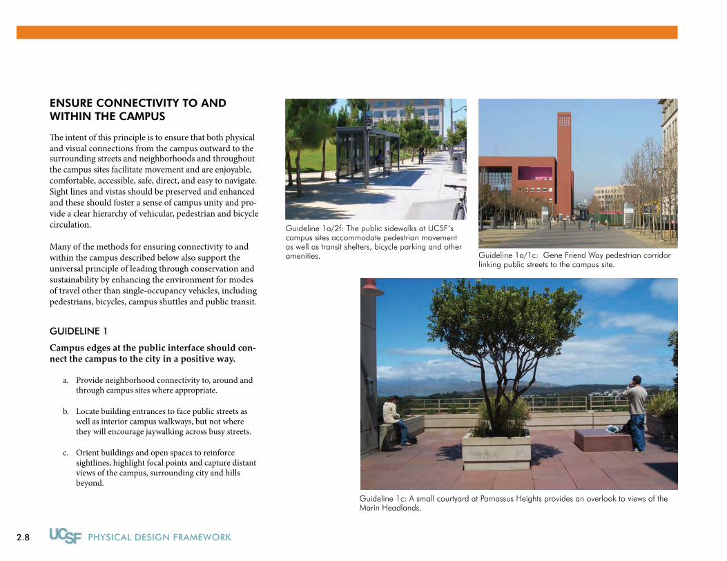
ENSURE CONNECTIVITY TO AND WITHIN THE CAMPUS
�e intent of this principle is to ensure that both physicaland visual connections from the campus outward to the surrounding streets and neighborhoods and throughout the campus sites facilitate movement and are enjoyable, comfortable, accessible, safe, direct, and easy to navigate. Sight lines and vistas should be preserved and enhanced and these should foster a sense of campus unity and pro-vide a clear hierarchy of vehicular, pedestrian and bicycle circulation.
Many of the methods for ensuring connectivity to andwithin the campus described below also support theuniversal principle of leading through conservation andsustainability by enhancing the environment for modesof travel other than single-occupancy vehicles, includingpedestrians, bicycles, campus shuttles and public transit.
GUIDELINE 1
Campus edges at the public interface should con-nect the campus to the city in a positive way.
Provide neighborhood connectivity to, around and a. through campus sites where appropriate.
Locate building entrances to face public streets as b. well as interior campus walkways, but not where they will encourage jaywalking across busy streets.
Orient buildings and open spaces to reinforce c. sightlines, highlight focal points and capture distant views of the campus, surrounding city and hills beyond.
Guideline 1a/2f: The public sidewalks at UCSF’s campus sites accommodate pedestrian movement as well as transit shelters, bicycle parking and other amenities.
Guideline 1c: A small courtyard at Parnassus Heights provides an overlook to views of the Marin Headlands.
Guideline 1a/1c: Gene Friend Way pedestrian corridor linking public streets to the campus site.

2.9
UNIVERSAL PLANNING & DESIGN PRINCIPLES
GUIDELINE 2
Circulation routes on campus should facilitate efficient, accessible and comfortable access and circulation for all modes.
Connect all building entrances as directly as a. possible with campus walkways while also meeting accessibility standards.
Design building entrances to accommodate b. anticipated levels of foot traffic, with ample seating at strategic locations, lighting, landscaping and other amenities.
Install bicycle racks at convenient locations c. throughout campus sites where they will be the most secure and preferably protected from the weather.
Design new roads, parking and loading on UCSF d. sites to not only accommodate projected campus traffic volumes, but also to minimize their visual impact and conflict as little as possible with pedestrian movements.
Given UCSF’s location in a dense urban e. environment with strong public transportation options, promote the use of public transit in campus plans.
Coordinate with City transportation agencies to f. locate and design public transportation elements such as transit stops, bicycle routes, and street crossings to ensure convenient access to alternate modes of transportation for students, faculty, staff and visitors.
Guideline 2a: The north edge of Saunders Court at Parnassus Heights provides an important east-west connection.
Guideline 2c: Bicycle racks at Mission Bay provide convenient and secure bicycle parking for students, faculty and staff.
2.10 PHYSICAL DESIGN FRAMEWORK
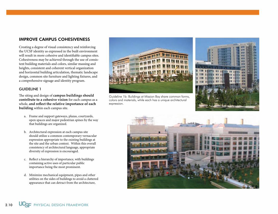
IMPROVE CAMPuS COHESIVENESS
Creating a degree of visual consistency and reinforcing the UCSF identity as expressed in the built environment will result in more cohesive and identifiable campus sites. Cohesiveness may be achieved through the use of consis-tent building materials and colors, similar massing and heights, consistent and coherent vertical organization and horizontal building articulation, thematic landscape design, common site furniture and lighting fixtures, and a comprehensive signage and identity program.
GUIDELINE 1
The siting and design of campus buildings should contribute to a cohesive vision for each campus as a whole, and reflect the relative importance of each building within each campus site.
Frame and support gateways, plazas, courtyards, a. open spaces and major pedestrian spines by the way that buildings are organized.
Architectural expression at each campus site b. should utilize a common contemporary vernacular expression appropriate to the existing buildings at the site and the urban context. Within this overall consistency of architectural language, appropriate diversity of expression is encouraged.
Reflect a hierarchy of importance, with buildings c. containing active uses of particular public importance being the most prominent.
Minimize mechanical equipment, pipes and other d. utilities on the sides of buildings to avoid a cluttered appearance that can detract from the architecture,
Guideline 1b: Buildings at Mission Bay share common forms, colors and materials, while each has a unique architectural expression.
2.11
UNIVERSAL PLANNING & DESIGN PRINCIPLES
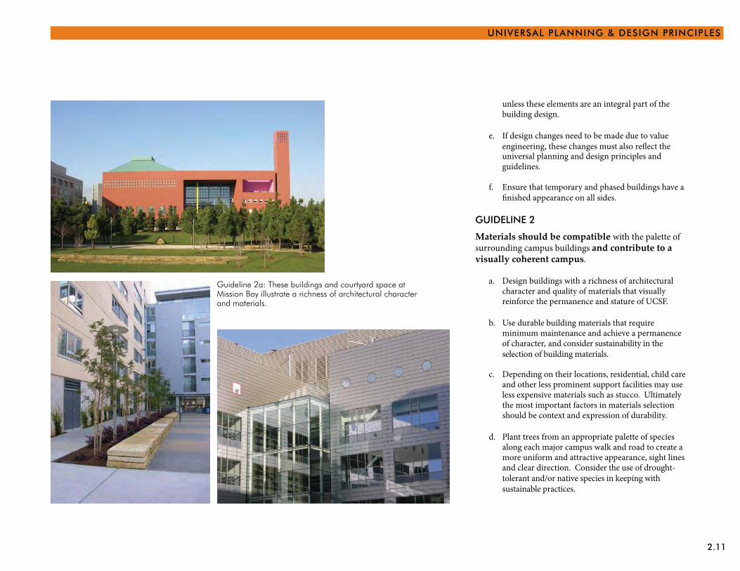
unless these elements are an integral part of the building design.
If design changes need to be made due to valueengineering, these changes must also re�ect the
e.
universal planning and design principles and guidelines.
Ensure that temporary and phased buildings have a�nished appearance on all sides.
f.
GUIDELINE 2
Materials should be compatible with the palette of surrounding campus buildings and contribute to a visually coherent campus.
Design buildings with a richness of architectural a. character and quality of materials that visually reinforce the permanence and stature of UCSF.
Use durable building materials that require b. minimum maintenance and achieve a permanence of character, and consider sustainability in the selection of building materials.
Depending on their locations, residential, child care c. and other less prominent support facilities may use less expensive materials such as stucco. Ultimately the most important factors in materials selection should be context and expression of durability.
Plant trees from an appropriate palette of species d. along each major campus walk and road to create a more uniform and attractive appearance, sight lines and clear direction. Consider the use of drought-tolerant and/or native species in keeping with sustainable practices.
Guideline 2a: These buildings and courtyard space at Mission Bay illustrate a richness of architectural character and materials.
2.12 PHYSICAL DESIGN FRAMEWORK
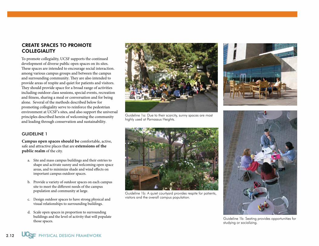
CREATE SPACES TO PROMOTE COLLEGIALITY
To promote collegiality, UCSF supports the continueddevelopment of diverse public open spaces on its sites.�ese spaces are intended to encourage social interaction.among various campus groups and between the campusand surrounding community. �ey are also intended to provide areas of respite and quiet for patients and visitors.�ey should provide space for a broad range of activitiesincluding outdoor class sessions, special events, recreationand �tness, sharing a meal or conversation and for beingalone. Several of the methods described below for promoting collegiality serve to reinforce the pedestrianenvironment at UCSF’s sites, and also support the universalprinciples described herein of welcoming the communityand leading through conservation and sustainability.
GUIDELINE 1
Campus open spaces should be comfortable, active, safe and attractive places that are extensions of the public realm of the city.
Site and mass campus buildings and their entries to a. shape and activate sunny and welcoming open spaceareas, and to minimize shade and wind e�ects on important campus outdoor spaces.
Provide a variety of outdoor spaces on each campussite to meet the di�erent needs of the campus
b.
population and community at large.
Design outdoor spaces to have strong physical and c. visual relationships to surrounding buildings.
Scale open spaces in proportion to surrounding d. buildings and the level of activity that will populate those spaces.
Guideline 1b: A quiet courtyard provides respite for patients, visitors and the overall campus population.
Guideline 1b: Seating provides opportunities for studying or socializing.
Guideline 1a: Due to their scarcity, sunny spaces are most highly used at Parnassus Heights.
2.13
UNIVERSAL PLANNING & DESIGN PRINCIPLES
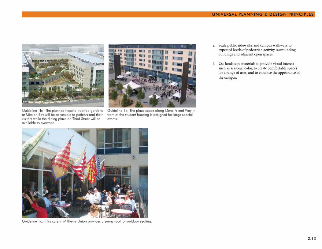
Guideline 1b: The planned hospital rooftop gardens at Mission Bay will be accessible to patients and their visitors while the dining plaza on Third Street will be available to everyone.
Guideline 1e: The plaza space along Gene Friend Way in front of the student housing is designed for large special events.
Guideline 1c: This cafe in Millberry Union provides a sunny spot for outdoor seating.
Scale public sidewalks and campus walkways to e. expected levels of pedestrian activity, surrounding buildings and adjacent open spaces.
Use landscape materials to provide visual interest f. such as seasonal color, to create comfortable spaces for a range of uses, and to enhance the appearance of the campus.
2.14 PHYSICAL DESIGN FRAMEWORK
LEAD THROUGH CONSERVATION AND SUSTAINABILITY
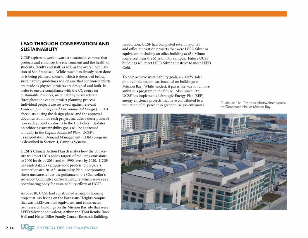
Guideline 1b: The solar photovoltaic system on Genentech Hall at Mission Bay.
UCSF aspires to work toward a sustainable campus thatprotects and enhances the environment and the health ofstudents, faculty and sta�, as well as the overall populat-tion of San Francisco. While much has already been done or is being planned, some of which is described below, sustainability guidelines will ensure that continued e�orts are made as physical projects are designed and built. In order to ensure compliance with the UC Policy on Sustainable Practices, sustainability is considered throughout the capital project planning process. Individual projects are reviewed against relevant Leadership in Energy and Environmental Design (LEED) checklists during the design phase, and the approval documentation for each project includes a description of how each project conforms to the UC Policy. Updateson achieving sustainability goals will be addressed annually in the Capital Financial Plan. UCSF’s Transportation Demand Management (TDM) programis described in Section 4, Campus Systems.
UCSF’s Climate Action Plan describes how the Univer-sity will meet UC’s policy targets of reducing emissionsto 2000 levels by 2014 and to 1990 levels by 2020. UCSFhas undertaken a campus-wide process to prepare acomprehensive 2010 Sustainability Plan incorporatingthose measures under the guidance of the Chancellor’sAdvisory Committee on Sustainability, which serves as acoordinating body for sustainability e�orts at UCSF.
As of 2010, UCSF had constructed a campus housingproject at 145 Irving on the Parnassus Heights campusthat was LEED certi�ed equivalent, and constructedtwo research buildings on the Mission Bay site that wereLEED Silver or equivalent, Arthur and Toni Rembe RockHall and Helen Diller Family Cancer Research Building.
In addition, UCSF had completed seven major laband o�ce renovation projects that were LEED Silver orequivalent, including an o�ce building at 654 Minne-sota Street near the Mission Bay campus. Future UCSFbuildings will meet LEED Silver and strive to meet LEED Gold.
To help achieve sustainability goals, a 250KW solar photovoltaic system was installed on buildings at Mission Bay. While modest, it paves the way for a more ambitious program in the future. Also, since 1990, UCSF has implemented Strategic Energy Plan (SEP) energy e�ciency projects that have contributed to a reduction of 35 percent in greenhouse gas emissions.
2.15
UNIVERSAL PLANNING & DESIGN PRINCIPLES
GUIDELINE 2
Open space areas, including streets and parking lots, should be designed to be environmentally sus-tainable.
Use native and drought tolerent plants, plants thatbene�t wildlife and water conserving plants and
a.
planting methods in the landscape.
Landscape areas of extensive paving with trees to b. mitigate extreme solar and thermal conditions.
Locate and design open space areas to maximize c. sun exposure and minimize exposure to prevailing winds.
d. Minimize site runo� by increasing on-sitein�ltration where appropriate, grade for gravity �owand otherwise design to meet storm water objectives and standards, keeping in mind local stormwater guidelines and best management practices.
e. Install irrigation systems that are e�cient and waterconserving.
Encourage the use of materials that promote f. environmentally healthy maintenance, durability and longevity.
GUIDELINE 3
Transportation system improvements should be designed to be environmentally sustainable.
Cooperate with local agencies to improve pedestrian a. links between UCSF facilities and BART, MUNI and other public transit connections.
Evaluate parking ratios and minimize parking to theextent practicable in an e�ort to continue to strive to
b.
meet the City’s Transit First policy.
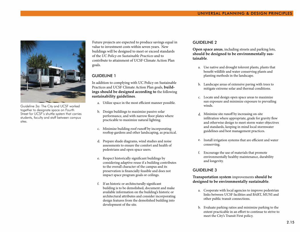
Guideline 3a: The City and UCSF worked together to designate space on Fourth Street for UCSF’s shuttle system that carries students, faculty and staff between campus sites.
Future projects are expected to produce savings equal invalue to investment costs within seven years. New buildings will be designed to meet or exceed standardsof the UC Policy on Sustainable Practices and tocontribute to attainment of UCSF Climate Action Plan goals.
GUIDELINE 1
In addition to complying with UC Policy on Sustainable Practices and UCSF Climate Action Plan goals, build-ings should be designed according to the following sustainability guidelines.
a.
Design buildings to maximize passive solarperformance, and with narrow �oor plates where
b.
practicable to maximize natural lighting.
c.
Prepare shade diagrams, wind studies and noise d. assessments to ensure the comfort and health of pedestrians and open space users.
e. Respect historically signi�cant buildings byconsidering adaptive reuse if a building contributes to the overall character of the campus and itspreservation is �nancially feasible and does not impact space program goals or ceilings.
f. If an historic or architecturally signi�cantbuilding is to be demolished, document and make available information on the building’s historic or architectural attributes and consider incorporating design features from the demolished building into development of the site.
Minimize building roof runo� by incorporatingroo�op gardens and other landscaping, as practical.
Utilize space in the most e�cient manner possible.
2.16
3.1
3 | Planning & Design Framework
The six universal design principles described in the previ-ous section apply to all UCSF sites and address issues arising from their urban locations within the fabric of the City of San Francisco.
However, two primary UCSF sites - Parnassus Heights and Mission Bay - accommodate large populations and many diverse buildings and uses, including basic sci-ence, clinical and translational research and graduate academic programs, hospitals and outpatient clinics, and at Parnassus Heights, professional programs. Both sites are expected to experience significant change during the time frame of the next LRDP as a result of many factors.
At Parnassus Heights, the primary issues are the reme-diation or replacement of seismically deficient buildings, in particular UC Hall and the Clinical Sciences Building; the modernization of instructional, research and clinical space and the renovation of release space as new build-ings at Mission Bay are occupied; phased upgrading or replacement of obsolete building and mechanical systems to correct fire, life-safety and other code deficiencies, the presence of toxic hazards, building shell deterioration, the lack of efficient and sustainable utilities and utility distribution systems, and emergency and standby power system problems; and the improvement of the campus core and sites where buildings will be demolished.
At Mission Bay, space and facilities that support the new Medical Center enterprise must be developed, in particu-lar outpatient space, faculty offices, a parking structure and child care expansion. In addition, UCSF anticipates further development of the campus including major new facilities for programs in Global Health, Epidemiol-ogy, Biostatistics, Clinical and Translational Research, Molecular Medicine and the School of Pharmacy. As the campus is further developed, additional infrastructure, support facilities and open space will also be needed, in-cluding a utility distribution loop and sustainable energy and utility systems.
Consequently, these two sites have more complex plan-ning and design issues that will have to be addressed in the next LRDP.
This section describes the specific planning and design framework for each of these two campus sites and dem-onstrates how the universal planning and design prin-ciples can be applied.
3.2 PHYSICAL DESIGN FRAMEWORK
PARNASSuS HEIGHTS
Parnassus Heights is both the oldest and largest, in terms of size and population, of the sites that comprise UCSF. The site covers approximately 107 acres on the northern slope of Mount Sutro.
Of the total site, 61 acres are in the Mount Sutro Open Space Reserve. The Reserve was established in 1975; in 1976 the Reserve was expanded to 61 acres, with perma-nent restrictions on development. Uses that already exist on Mount Sutro, but which are excluded from the Re-serve, include Aldea San Miguel Student Family Housing, the Chancellor’s residence, and the 5-acre Woods parcel with two buildings and two parking lots.
On the remaining 46 acres of the campus, about 3.7 million gross square feet (gsf) of building space, includ-ing parking garages, has been constructed, resulting in an extremely dense site with five buildings that are more than twelve stories tall. The buildings vary consider-ably in age, design, massing and height. Set against the 500-foot high, heavily forested backdrop of Mount Sutro, the building skyline of the campus is prominently visible from the north.
Many of the campus buildings on the south and most densely developed side of the campus are inter-connected at multiple levels into a large “megastructure.” These connections allow convenient, weather-protected move-ment throughout the site for faculty, staff and students. Most patients and visitors, however, arrive in cars, park in the structures across Parnassus Avenue to the north, and must find their way throughout the complex site to destinations on both the north and south sides. With inpatient and outpatient facilities, the Medical Center
Constraintsspace ceiling• parking supply and traffic impacts • (private vehicles and UCSF shuttles)steep topography • inability to expand developable land • areaseismic and other code difficulties• scale of surrounding urban • development.
Opportunitiesseveral possible demolition and • redevelopment sitesexisting high activity areas that can be • enhancedpartially complete circulation network • that can be strengthened as part of future projectsexcellent citywide transit connections• abundant and attractive open space • opportunities that can be integrated into the campus framework.
The buildings at Parnassus Heights encompass various architectural forms, styles and ages.
3.3
PLANNING & DESIGN FRAMEWORK
Parnassus Heights surrounded by Mount Sutro Open Space Reserve and residential neighborhoods.
3.4 PHYSICAL DESIGN FRAMEWORK
Medical Center entry signage, driveway and drop-off are clear and convenient for visitors to Parnassus Heights.
The campus is well-served by public light rail and bus transit service including this light rail stop on Irving Street.
The significant congestion on Parnassus Avenue results in conflicts between pedestrians, autos, illegally parked cars, the UCSF shuttle, and public transit.
Stairs at the edge of the Dental Clinics building provide access to higher elevations but are not welcoming.
Neighborhoods surrounding the campus are comprised primarily of residential uses, typically three- to four-stories in height.
3.5
PLANNING & DESIGN FRAMEWORK
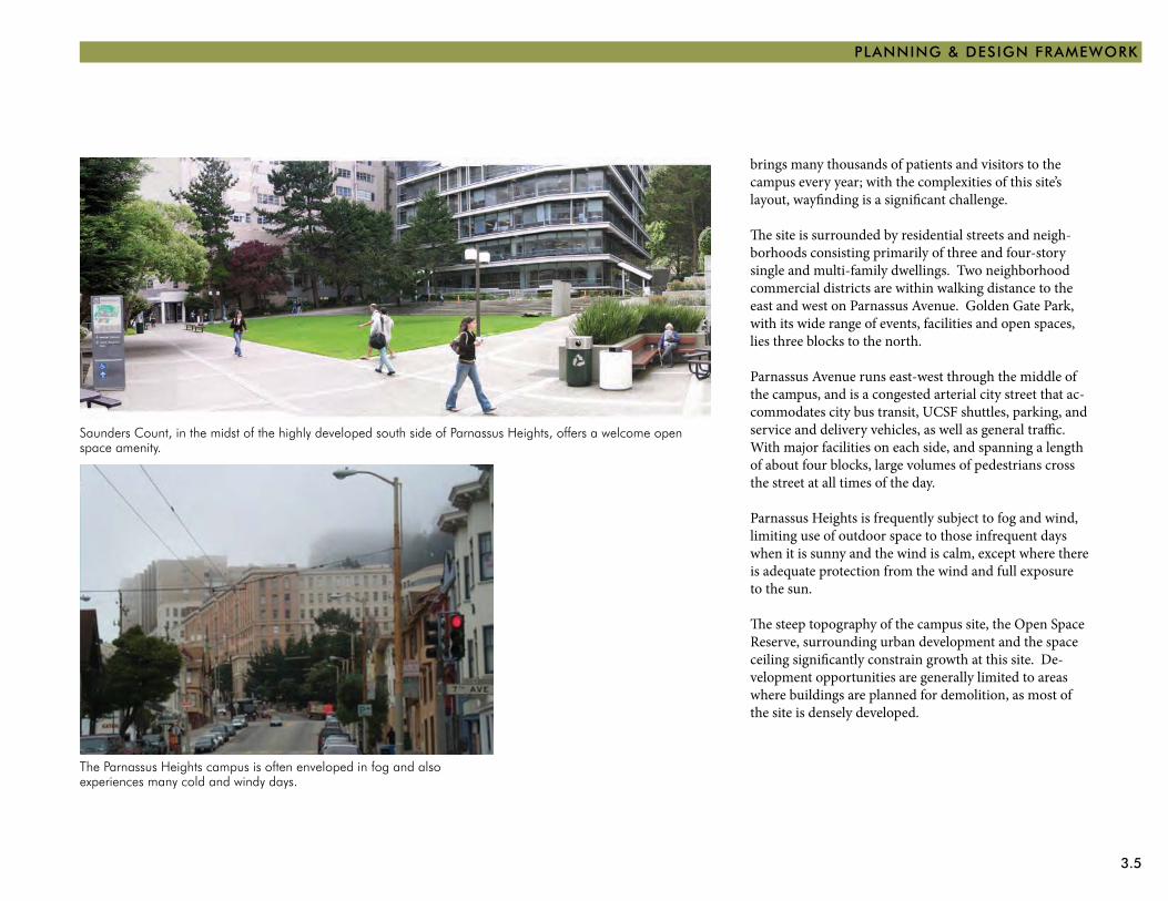
Saunders Count, in the midst of the highly developed south side of Parnassus Heights, offers a welcome open space amenity.
The Parnassus Heights campus is often enveloped in fog and also experiences many cold and windy days.
brings many thousands of patients and visitors to the campus every year; with the complexities of this site’s layout, wayfinding is a significant challenge.
The site is surrounded by residential streets and neigh-borhoods consisting primarily of three and four-story single and multi-family dwellings. Two neighborhood commercial districts are within walking distance to the east and west on Parnassus Avenue. Golden Gate Park, with its wide range of events, facilities and open spaces, lies three blocks to the north.
Parnassus Avenue runs east-west through the middle of the campus, and is a congested arterial city street that ac-commodates city bus transit, UCSF shuttles, parking, and service and delivery vehicles, as well as general traffic. With major facilities on each side, and spanning a length of about four blocks, large volumes of pedestrians cross the street at all times of the day.
Parnassus Heights is frequently subject to fog and wind, limiting use of outdoor space to those infrequent days when it is sunny and the wind is calm, except where there is adequate protection from the wind and full exposure to the sun.
The steep topography of the campus site, the Open Space Reserve, surrounding urban development and the space ceiling significantly constrain growth at this site. De-velopment opportunities are generally limited to areas where buildings are planned for demolition, as most of the site is densely developed.
3.6 PHYSICAL DESIGN FRAMEWORK
StRAtEGIES
The following section describes six strategies for imple-menting the universal planning and design principles and guidelines at the Parnassus Heights campus. It is based upon the Preliminary Parnassus Heights Design Goals and Guidelines, which identifies general goals for Parnassus Heights and includes guidelines by topic and area of the campus site.
These strategies flow directly from the six universal plan-ning and design principles. By strengthening UCSF’s identity and wayfinding with new, comprehensive signage, UCSF will be responding to CONTEXT while reinforcing its identity, welcoming the COMMUNITY, ensuring CONNECTIVITY and improving COHESIVE-NESS. Enhancing the campus core will be achieved by applying all of these principles, in addition to creating a space that promotes COLLEGIALITY. The same is true for enhancing the pedestrian experience and expand-ing the open space network, for which leading through CONSERVATION and sustainability will also apply. When developing opportunity areas, which will consist of buildings and open space, all six of the principles will be applicable. If transportation facilities are sited and designed according to the objectives in Section 6, all the principles will also be relevant.
The six planning and design strategies for Parnassus Heights include the following:
Strengthen Identity and Wayfinding1. With over a dozen campus sites throughout the city and other institutions with similar names (University of San Francisco and San Francisco State University) and acronyms (USF and SFSU), it is imperative that UCSF convey a consistent and distinct identity. At Parnassus Heights, it is important that visitors know when they have arrived at the campus site, and are able to easily find their way around once there.
Enhance the Campus Core2. With food service, recreation and student services lying to the north in Millberry Union, and high densities of medical, teaching, research and administrative functions across the street to the south, the physical center of the campus and focus of pedestrian activity is Parnassus Avenue. As the primary campus crossroads, the area suffers from congestion, pedestrian/vehicular conflicts, and poor physical condition and image. Improvements should expand usable outdoor space, ensure pedestrian safety and enjoyment, and mitigate traffic impacts.
Enhance the Pedestrian Experience3. With a major city arterial running through the center of the campus, and with a complex arrangement of destinations and changes in topography, pedestrians at Parnassus Heights face many challenges.
Expand the Open Space Network 4. Parnassus Heights is densely developed but has little usable, weather-protected open space to meet the needs of the campus population or visitors.
Develop Opportunity Areas5. At Parnassus Heights, growth cannot occur because of the space ceiling imposed by the Regents and the lack of developable land. Redevelopment can only be achieved through the demolition of buildings to free up development sites, construction on surface parking lots, or the renovation and reuse of existing, functionally deficient buildings.
Develop Transportation Facilities6. Unmet demand for parking, and congested passenger loading and commercial delivery areas on Parnassus Avenue, coupled with general vehicle and transit traffic, results in extensive illegal parking and loading of commercial vehicles and overall congestion. Implementation of the campus core concept will improve the pedestrian environment but will require relocating some of the parking and loading functions elsewhere.
3.7
PLANNING & DESIGN FRAMEWORK
S E
C O
N D
A
V E.
I R V I N G S T R E E T
A R
G U
E L
L O
A
V E.
C A R L S T R E E T
F I F
T H
A
V E
N U
E
T H
I R
D A
V E
N U
E
P A R N A S S U S A V E N U E
C A M P U S L I B R A R Y
M I L L B E R R Y U N I O N
P A R N A S S U S A V E N U E
A M B U L A T O R YC A R E C E N T E R M E D I C A L O F F I C E SH
I L
L W
A Y
A
V E
N U
E
H I
L L
P
O I
N T
A
V E.
F I F
T H
A
V E
N U
E
D E N T A LC L I N I C S B U I L D I N G
C H I L D C A R E
N U R S I N G S C H O O L O F
M O F F I T TH O S P I T A L
L O N G H O S P I T A L
M E
D I C
A L
C E
N T
E R
W A
Y
L A
B O
R A
T O
R Y
B U
I L
D I N
G
V I S
I O
N R
E S
E A
R C
H
K O
R E
T
W A
Y
W E S T
H E A L T HS C I E N C E SB U I L D I N G
H E A L T HS C I E N C E S
E A S TB U I L D I N G
S C I E N C E SB U I L D I N G
M E D I C A L
U T I L I T YC E N T R A L
P L A N TB U I L D I N G
P A R N A S S U SS E R V I C E S
E D G E W O O D R O A D
E D
G E
W O
O D
A
V E
.
F O
U R
T H
A
V E
N U
E
R E G E N E R AT I O N M E D I C I N E B U I L D I N G
L A N G L E Y P O R T E R P S Y C H I A T R IC I N S T I T U T E
U. C. H A L L
L A B O R A T O R Y O F R A D I O L O G Y
M E
D I
C A
L R
E S
E A
R C
H I
V
C L I N I C A L S C I E N C E S B L D G
North
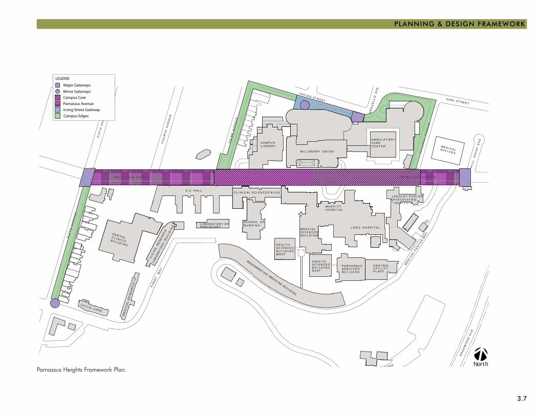
Major Gateways
LEGEND
Minor Gateways
Campus Core
Parnassus Avenue
Irving Street Gateway
Campus Edges
Parnassus Heights Framework Plan.
3.8 PHYSICAL DESIGN FRAMEWORK
UCSF Signage
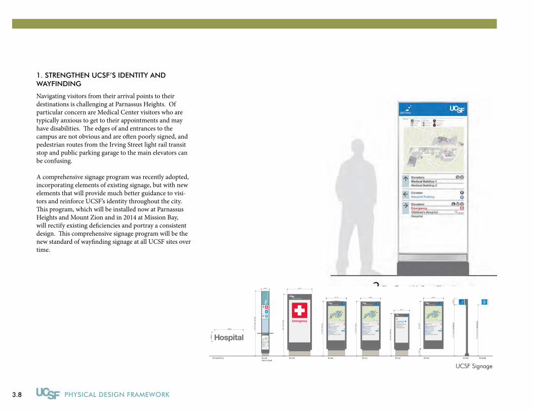
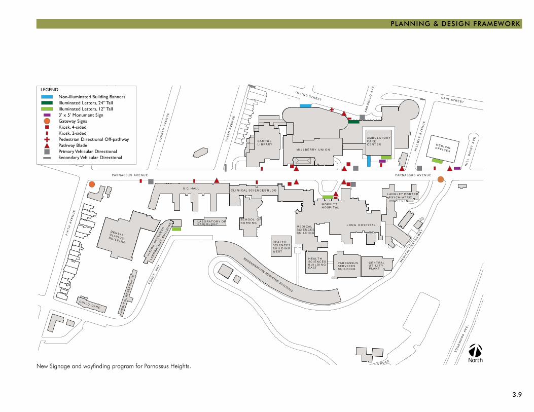
1. StRENGtHEN UCSF’S IDENtItY AND WAYFINDING
Navigating visitors from their arrival points to their destinations is challenging at Parnassus Heights. Of particular concern are Medical Center visitors who are typically anxious to get to their appointments and may have disabilities. The edges of and entrances to the campus are not obvious and are often poorly signed, and pedestrian routes from the Irving Street light rail transit stop and public parking garage to the main elevators can be confusing.
A comprehensive signage program was recently adopted, incorporating elements of existing signage, but with new elements that will provide much better guidance to visi-tors and reinforce UCSF’s identity throughout the city. This program, which will be installed now at Parnassus Heights and Mount Zion and in 2014 at Mission Bay, will rectify existing deficiencies and portray a consistent design. This comprehensive signage program will be the new standard of wayfinding signage at all UCSF sites over time.
Emergency
513Parnassus Ave.
MedicalSciences
3'-0"
5'-7
"
400Parnassus Ave.
MedicalBuilding 1
5'-7
"
4'-0"
7'-0
" A
.F.G
. (M
INIM
UM
)9
5/8"
TML
Emergency
Elevators L,M,TChildren’s HospitalDental ClinicMoffitt-Long Hospital
Crede BuildingMillberry UnionParking Garage
2'-9"
11 1
/4"
11 1
/4"
6'-6
1/4
"
Emergency
Medical Building OneMillberry UnionParking Garage
Elevators L, M, TDental ClinicHospitalUCSF Children’s Hospital
2'-9"
6'-6
1/4
"
Medical Building One
2330Post St.
7'-5"
4'-2
"ex
istin
g w
all
V.I.F
Emergency
Medical Building OneMillberry UnionParking Garage
Elevators L, M, TDental ClinicHospitalUCSF Children’s Hospital
2'-9"
7'-5
1/2
" A
.F.G
Emergency
Medical Building OneMillberry UnionParking Garage
Elevators L, M, TDental ClinicHospitalUCSF Children’s Hospital
2'-9"
7'-5
1/2
" (A
.F.G
.)Take Elevator to Floor 1 for easier access to UCSF andParnassus Ave.
5'-9
1/2
" (A
.F.G
.)
2'-1"
vari
es
varies
4'-0"
10'-
1 1/
4" A
.F.G
.
Emergency
Medical Building OneMillberry UnionParking Garage
Elevators L, M, TDental ClinicHospitalUCSF Children’s Hospital
Emergency
Hospital
Parking
21'-
9", n
om
. (A
.F.G
)
2'-9"
ST1111 ST1112A ST1114 ST1115 ST1134 ST1145A/B
ST120/ST121 ST130Not to Scale
ST135 ST140 ST141 ST142 ST145 ST155 ST400B
4'-0"
7'-0
" A
.F.F
. (6'
-8"M
INIM
UM
)
Medical Sciences5"
1'-5
"
UCSF Medical CenterExterior Sign Family — In Use (Parnassus Heights and Mount Zion)
3.9
PLANNING & DESIGN FRAMEWORK
S E
C O
N D
A
V E.
I R V I N G S T R E E T
A R
G U
E L
L O
A
V E.
C A R L S T R E E T
F I F
T H
A
V E
N U
E
T H
I R
D A
V E
N U
E
P A R N A S S U S A V E N U E
C A M P U S L I B R A R Y
M I L L B E R R Y U N I O N
P A R N A S S U S A V E N U E
A M B U L A T O R YC A R E C E N T E R M E D I C A L O F F I C E SH
I L
L W
A Y
A
V E
N U
E
H I
L L
P
O I
N T
A
V E.
F I F
T H
A
V E
N U
E
D E N T A LC L I N I C S B U I L D I N G
C H I L D C A R E
N U R S I N G S C H O O L O F
M O F F I T TH O S P I T A L
L O N G H O S P I T A L
M E
D I C
A L
C E
N T
E R
W A
Y
L A
B O
R A
T O
R Y
B U
I L
D I N
G
V I S
I O
N R
E S
E A
R C
H
K O
R E
T
W A
Y
W E S T
H E A L T HS C I E N C E SB U I L D I N G
H E A L T HS C I E N C E S
E A S TB U I L D I N G
S C I E N C E SB U I L D I N G
M E D I C A L
U T I L I T YC E N T R A L
P L A N TB U I L D I N G
P A R N A S S U SS E R V I C E S
E D G E W O O D R O A D
E D
G E
W O
O D
A
V E
.
F O
U R
T H
A
V E
N U
E
R E G E N E R AT I O N M E D I C I N E B U I L D I N G
L A N G L E Y P O R T E R P S Y C H I A T R IC I N S T I T U T E
U. C. H A L L
L A B O R A T O R Y O F R A D I O L O G Y
M E
D I
C A
L R
E S
E A
R C
H I
V
C L I N I C A L S C I E N C E S B L D G
North
Non-illuminated Building BannersIlluminated Letters, 24” TallIlluminated Letters, 12” Tall3’ x 5’ Monument SignGateway SignsKiosk, 4-sidedKiosk, 2-sidedPedestrian Directional Off-pathwayPathway BladePrimary Vehicular DirectionalSecondary Vehicular Directional
LEGEND
New Signage and wayfinding program for Parnassus Heights.
3.10 PHYSICAL DESIGN FRAMEWORK
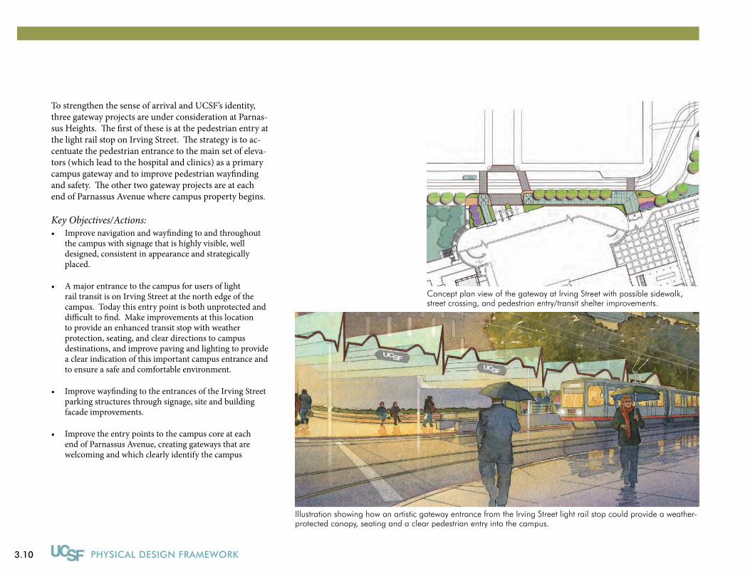
Illustration showing how an artistic gateway entrance from the Irving Street light rail stop could provide a weather-protected canopy, seating and a clear pedestrian entry into the campus.
To strengthen the sense of arrival and UCSF’s identity, three gateway projects are under consideration at Parnas-sus Heights. The first of these is at the pedestrian entry at the light rail stop on Irving Street. The strategy is to ac-centuate the pedestrian entrance to the main set of eleva-tors (which lead to the hospital and clinics) as a primary campus gateway and to improve pedestrian wayfinding and safety. The other two gateway projects are at each end of Parnassus Avenue where campus property begins.
Key Objectives/Actions:Improve navigation and wayfinding to and throughout •the campus with signage that is highly visible, well designed, consistent in appearance and strategically placed.
A major entrance to the campus for users of light •rail transit is on Irving Street at the north edge of the campus. Today this entry point is both unprotected and difficult to find. Make improvements at this location to provide an enhanced transit stop with weather protection, seating, and clear directions to campus destinations, and improve paving and lighting to provide a clear indication of this important campus entrance and to ensure a safe and comfortable environment.
Improve wayfinding to the entrances of the Irving Street •parking structures through signage, site and building facade improvements.
Improve the entry points to the campus core at each •end of Parnassus Avenue, creating gateways that are welcoming and which clearly identify the campus
Concept plan view of the gateway at Irving Street with possible sidewalk, street crossing, and pedestrian entry/transit shelter improvements.
3.11
PLANNING & DESIGN FRAMEWORK
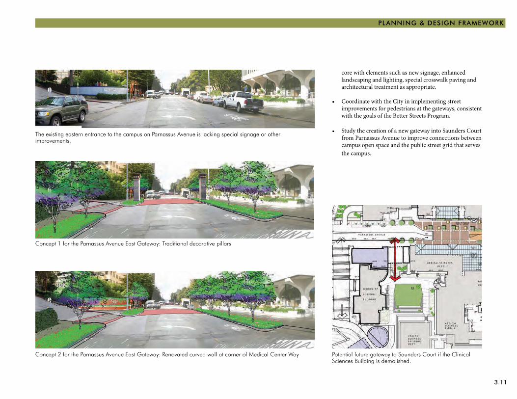
Concept 1 for the Parnassus Avenue East Gateway: Traditional decorative pillars
Concept 2 for the Parnassus Avenue East Gateway: Renovated curved wall at corner of Medical Center Way
The existing eastern entrance to the campus on Parnassus Avenue is lacking special signage or other improvements.
Potential future gateway to Saunders Court if the Clinical Sciences Building is demolished.
core with elements such as new signage, enhanced landscaping and lighting, special crosswalk paving and architectural treatment as appropriate.
Coordinate with the City in implementing street •improvements for pedestrians at the gateways, consistent with the goals of the Better Streets Program.
Study the creation of a new gateway into Saunders Court •from Parnassus Avenue to improve connections between campus open space and the public street grid that serves the campus.
3.12 PHYSICAL DESIGN FRAMEWORK
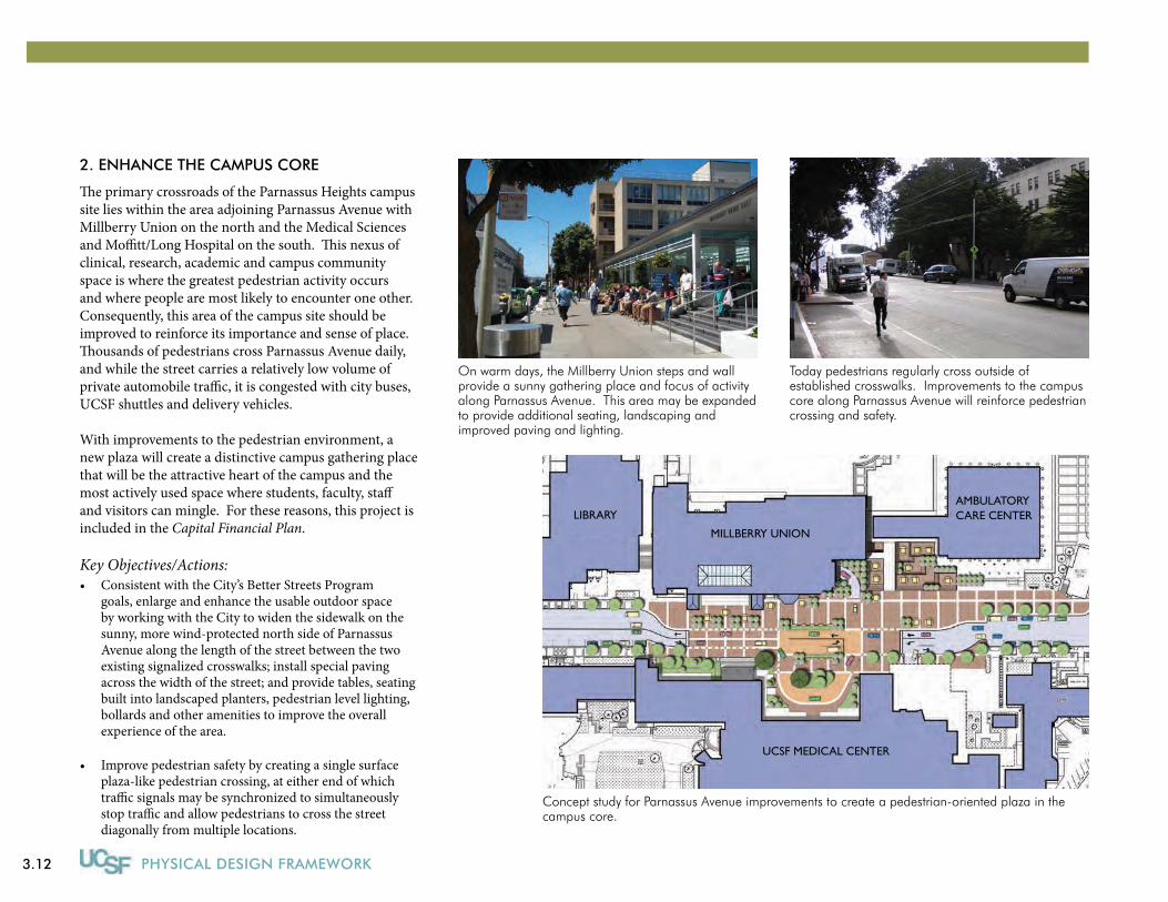
2. ENHANCE tHE CAMPUS CORE
The primary crossroads of the Parnassus Heights campus site lies within the area adjoining Parnassus Avenue with Millberry Union on the north and the Medical Sciences and Moffitt/Long Hospital on the south. This nexus of clinical, research, academic and campus community space is where the greatest pedestrian activity occurs and where people are most likely to encounter one other. Consequently, this area of the campus site should be improved to reinforce its importance and sense of place. Thousands of pedestrians cross Parnassus Avenue daily, and while the street carries a relatively low volume of private automobile traffic, it is congested with city buses, UCSF shuttles and delivery vehicles.
With improvements to the pedestrian environment, a new plaza will create a distinctive campus gathering place that will be the attractive heart of the campus and the most actively used space where students, faculty, staff and visitors can mingle. For these reasons, this project is included in the Capital Financial Plan.
Key Objectives/Actions:Consistent with the City’s Better Streets Program •goals, enlarge and enhance the usable outdoor space by working with the City to widen the sidewalk on the sunny, more wind-protected north side of Parnassus Avenue along the length of the street between the two existing signalized crosswalks; install special paving across the width of the street; and provide tables, seating built into landscaped planters, pedestrian level lighting, bollards and other amenities to improve the overall experience of the area.
Improve pedestrian safety by creating a single surface •plaza-like pedestrian crossing, at either end of which traffic signals may be synchronized to simultaneously stop traffic and allow pedestrians to cross the street diagonally from multiple locations.
Today pedestrians regularly cross outside of established crosswalks. Improvements to the campus core along Parnassus Avenue will reinforce pedestrian crossing and safety.
Concept study for Parnassus Avenue improvements to create a pedestrian-oriented plaza in the campus core.
On warm days, the Millberry Union steps and wall provide a sunny gathering place and focus of activity along Parnassus Avenue. This area may be expanded to provide additional seating, landscaping and improved paving and lighting.
LIBRARYAMBULATORY CARE CENTER
MILLBERRY UNION
UCSF MEDICAL CENTER
3.13
PLANNING & DESIGN FRAMEWORK
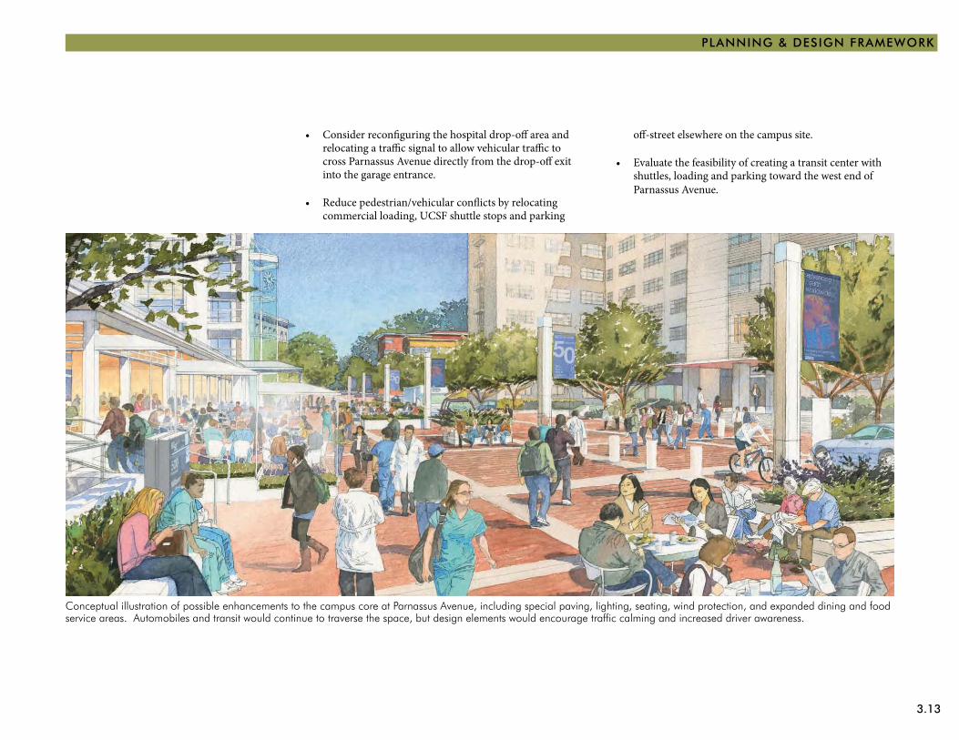
Conceptual illustration of possible enhancements to the campus core at Parnassus Avenue, including special paving, lighting, seating, wind protection, and expanded dining and food service areas. Automobiles and transit would continue to traverse the space, but design elements would encourage traffic calming and increased driver awareness.
off-street elsewhere on the campus site.
Evaluate the feasibility of creating a transit center with •shuttles, loading and parking toward the west end of Parnassus Avenue.
Consider reconfiguring the hospital drop-off area and •relocating a traffic signal to allow vehicular traffic to cross Parnassus Avenue directly from the drop-off exit into the garage entrance.
Reduce pedestrian/vehicular conflicts by relocating •commercial loading, UCSF shuttle stops and parking
3.14 PHYSICAL DESIGN FRAMEWORK
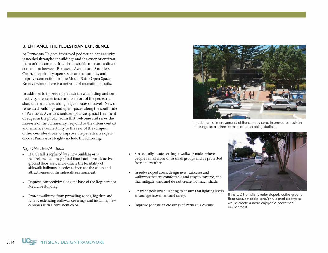
In addition to improvements at the campus core, improved pedestrian crossings on all street corners are also being studied.
If the UC Hall site is redeveloped, active ground floor uses, setbacks, and/or widened sidewalks would create a more enjoyable pedestrian environment.
3. ENHANCE tHE PEDEStRIAN ExPERIENCE
At Parnassus Heights, improved pedestrian connectivity is needed throughout buildings and the exterior environ-ment of the campus. It is also desirable to create a direct connection between Parnassus Avenue and Saunders Court, the primary open space on the campus, and improve connections to the Mount Sutro Open Space Reserve where there is a network of recreational trails.
In addition to improving pedestrian wayfinding and con-nectivity, the experience and comfort of the pedestrian should be enhanced along major routes of travel. New or renovated buildings and open spaces along the south side of Parnassus Avenue should emphasize special treatment of edges in the public realm that welcome and serve the interests of the community, respond to the urban context and enhance connectivity to the rear of the campus. Other considerations to improve the pedestrian experi-ence at Parnassus Heights include the following.
Key Objectives/Actions:If UC Hall is replaced by a new building or is •redeveloped, set the ground floor back, provide active ground floor uses, and evaluate the feasibility of sidewalk bulbouts in order to increase the width and attractiveness of the sidewalk environment.
Improve connectivity along the base of the Regeneration •Medicine Building.
Protect walkways from prevailing winds, fog drip and •rain by extending walkway coverings and installing new canopies with a consistent color.
Strategically locate seating at walkway nodes where •people can sit alone or in small groups and be protected from the weather.
In redeveloped areas, design new staircases and •walkways that are comfortable and easy to traverse, and that mitigate wind and do not create too much shade.
Upgrade pedestrian lighting to ensure that lighting levels •encourage movement and safety.
Improve pedestrian crossings of Parnassus Avenue.•
3.15
PLANNING & DESIGN FRAMEWORK
Pedestrian Circulation Framework
S E
C O
N D
A
V E.
I R V I N G S T R E E T
A R
G U
E L
L O
A
V E.
C A R L S T R E E T
F I F
T H
A
V E
N U
E
T H
I R
D A
V E
N U
E
P A R N A S S U S A V E N U E
C A M P U S L I B R A R Y
M I L L B E R R Y U N I O N
P A R N A S S U S A V E N U E
A M B U L A T O R YC A R E C E N T E R M E D I C A L O F F I C E SH
I L
L W
A Y
A
V E
N U
E
H I
L L
P
O I
N T
A
V E.
F I F
T H
A
V E
N U
E
D E N T A LC L I N I C S B U I L D I N G
C H I L D C A R E
N U R S I N G S C H O O L O F
M O F F I T TH O S P I T A L
L O N G H O S P I T A L
M E
D I C
A L
C E
N T
E R
W A
Y
L A
B O
R A
T O
R Y
B U
I L
D I N
G
V I S
I O
N R
E S
E A
R C
H
K O
R E
T
W A
Y
W E S T
H E A L T HS C I E N C E SB U I L D I N G
H E A L T HS C I E N C E S
E A S TB U I L D I N G
S C I E N C E SB U I L D I N G
M E D I C A L
U T I L I T YC E N T R A L
P L A N TB U I L D I N G
P A R N A S S U SS E R V I C E S
E D G E W O O D R O A D
E D
G E
W O
O D
A
V E
.
F O
U R
T H
A
V E
N U
E
R E G E N E R AT I O N M E D I C I N E B U I L D I N G
L A N G L E Y P O R T E R P S Y C H I A T R IC I N S T I T U T E
U. C. H A L L
L A B O R A T O R Y O F R A D I O L O G Y
M E
D I
C A
L R
E S
E A
R C
H I
V
C L I N I C A L S C I E N C E S B L D G
North
Campus Core: Special Pedestrian Zone
Pedestrian Spine
Public Sidewalks
Campus Sidewalks and Paths
Major Interior Paths
Future Connections
Potential Future Development Opportunity Sites
LEGEND

3.16 PHYSICAL DESIGN FRAMEWORK
Develop new courtyards and plazas in opportunity •areas, which are appropriately scaled, sheltered and furnished.
Create a special character for each significant outdoor •space but generally maintain uniformity in site furnishings and materials.
Whenever possible, locate and design open spaces •to capture distant views of the Pacific Ocean, Marin Headlands and Mount Sutro.
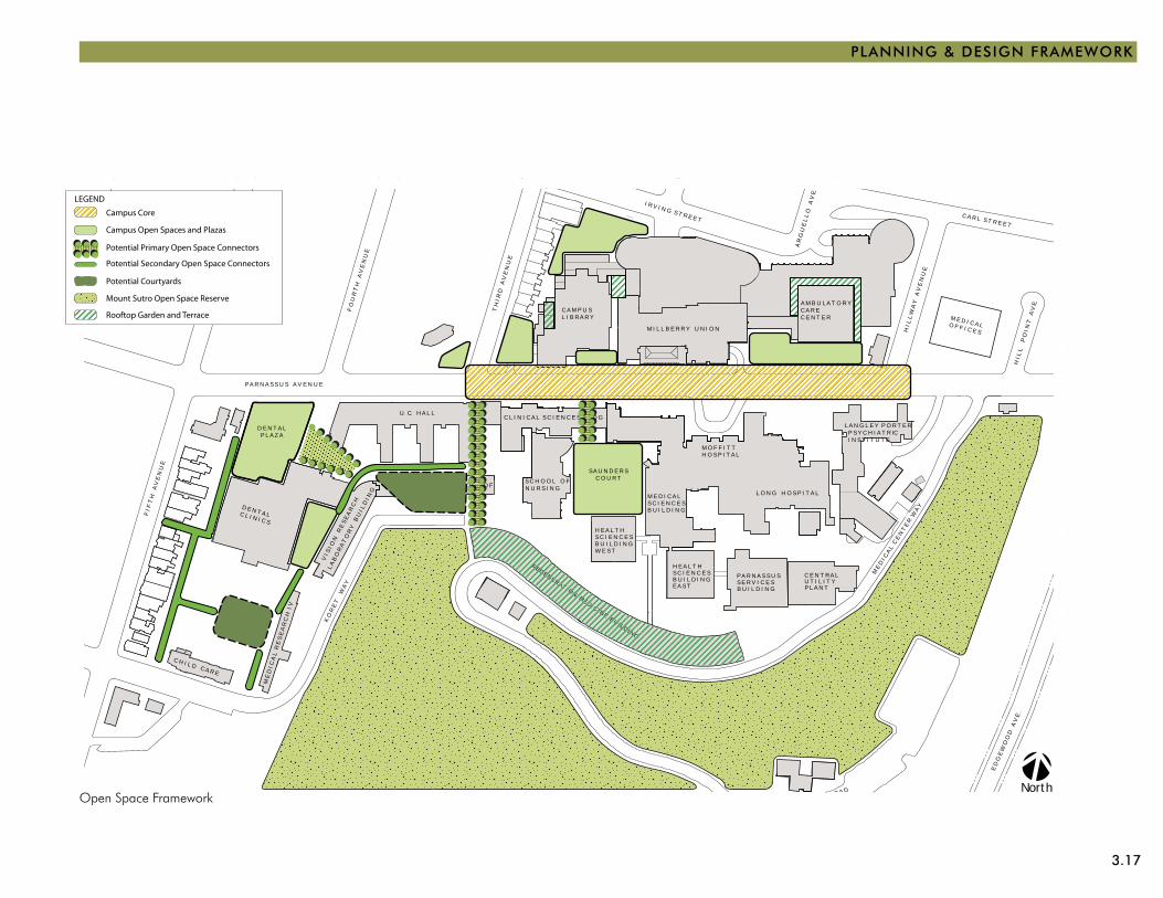
4. ExPAND tHE OPEN SPACE NEtWORK
The primary open space on the campus is Saunders Court, which is not directly accessible from Parnassus Avenue or linked with other campus open spaces. Sev-eral plazas of various sizes, all with limited seating, are spread throughout the campus. The most used outdoor space is the sidewalk adjacent to Millberry Union, on the sunny side of Parnassus Avenue in the center of the campus. Up the hill is the 61-acre Mount Sutro Open Space Reserve.
The open space network at Parnassus Heights should be expanded and existing outdoor areas improved. Land-scaping should emphasize the use of native species to promote biodiversity as well as plant materials that will enhance the overall appearance of the campus, help unify the outdoor spaces and walkways, provide a human scale to the buildings and complement the built environment.
Key Objectives/Actions:Renovate Saunders Court and other existing open spaces •to make it more usable, enjoyable and attractive.
Create new open spaces to accommodate a variety of •activities and number of users, from large audience performances to tranquil spaces for individual reflection.
Provide more seating for individuals and small groups in •sunny, protected areas.
Replace site furnishings, lighting and signs that are in •poor condition or inconsistent with the overall design strategy.
Utilize landscape materials and methods that are •environmentally sustainable per the university guidelines.
The renovation of Saunders Court (per plan and model above) will capitalize on areas of sunlight and shelter to provide places to gather, relax and hold special events.
POTENTIAL FUTURE LINKAGE TO PARNASSUS AVENUE
Existing Saunders Court is often shady.
3.17
PLANNING & DESIGN FRAMEWORK
S E
C O
N D
A
V E.
I R V I N G S T R E E T
A R
G U
E L
L O
A
V E.
C A R L S T R E E T
F I F
T H
A
V E
N U
E
T H
I R
D A
V E
N U
E
P A R N A S S U S A V E N U E
C A M P U S L I B R A R Y
M I L L B E R R Y U N I O N
P A R N A S S U S A V E N U E
A M B U L A T O R YC A R E C E N T E R M E D I C A L O F F I C E SH
I L
L W
A Y
A
V E
N U
E
H I
L L
P
O I
N T
A
V E.
F I F
T H
A
V E
N U
E
D E N T A LC L I N I C S
C H I L D C A R E
N U R S I N G S C H O O L O F
M O F F I T TH O S P I T A L
L O N G H O S P I T A L
M E
D I C
A L
C E
N T
E R
W A
Y
L A
B O
R A
T O
R Y
B U
I L
D I N
G
V I S
I O
N R
E S
E A
R C
H
K O
R E
T
W A
Y
W E S T
H E A L T HS C I E N C E SB U I L D I N G
H E A L T HS C I E N C E S
E A S TB U I L D I N G
S C I E N C E SB U I L D I N G
M E D I C A L
U T I L I T YC E N T R A L
P L A N TB U I L D I N G
P A R N A S S U SS E R V I C E S
E D G E W O O D R O A D
E D
G E
W O
O D
A
V E
.
F O
U R
T H
A
V E
N U
E
R E G E N E R AT I O N M E D I C I N E B U I L D I N G
L A N G L E Y P O R T E R P S Y C H I A T R IC I N S T I T U T E
U. C. H A L L
L A B O R A T O R Y O F R A D I O L O G Y
M E
D I
C A
L R
E S
E A
R C
H I
V
C L I N I C A L S C I E N C E S B L D G
North
S A U N D E R SC O U R T
D E N T A LP L A Z A
LEGEND
Potential Secondary Open Space Connectors
Campus Open Spaces and Plazas
Potential Primary Open Space Connectors
Campus Core
Mount Sutro Open Space Reserve
Potential Courtyards
Rooftop Garden and Terrace
Open Space Framework
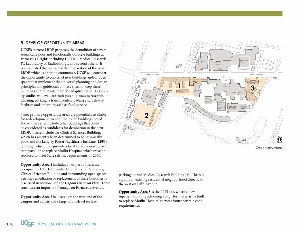
3.18 PHYSICAL DESIGN FRAMEWORK
5. DEVELOP OPPORTUNITY AREAS
UCSF’s current LRDP proposes the demolition of several seismically poor and functionally obsolete buildings at Parnassus Heights including UC Hall, Medical Research IV, Laboratory of Radiobiology, and several others. It is anticipated that as part of the preparation of the next LRDP, which is about to commence, UCSF will consider the opportunity to construct new buildings and/or open spaces that implement the universal planning and design principles and guidelines at these sites, or keep these buildings and renovate them for adaptive reuse. Feasibil-ity studies will evaluate such potential uses as research, housing, parking, a transit center, loading and delivery facilities and amenities such as food service.
�ree primary opportunity areas are potentially availablefor redevelopment. In addition to the buildings noted above, these sites include other buildings that could be considered as candidates for demolition in the nextLRDP. �ese include the Clinical Sciences Building, which has recently been determined to be seismically poor, and the Langley Porter Psychiatric Institute (LPPI) building, which may provide a location for a new inpa-tient pavillion to replace Mo�tt Hospital, which must bereplaced to meet State seismic requirements by 2030.
Opportunity Area 1 includes all or part of the sites occupied by UC Hall, nearby Laboratory of Radiology, Clinical Sciences Building and surrounding open spaces. Seismic remediation or replacement of these buildings is discussed in section 3 of the Capital Financial Plan. �eseconstitute an important frontage on Parnassus Avenue.
Opportunity Area 2 is located on the west end of the campus and consists of a large, multi-level surface
Opportunity Areas
S E
C O
N D
A
V E.
I R V I N G S T R E E T
A R
G U
E L
L O
A
V E.
C A R L S T R E E T
F I F
T H
A
V E
N U
E
T H
I R
D A
V E
N U
E
P A R N A S S U S A V E N U E
C A M P U S L I B R A R Y
M I L L B E R R Y U N I O N
P A R N A S S U S A V E N U E
A M B U L A T O R YC A R E C E N T E R M E D I C A L O F F I C E SH
I L
L W
A Y
A
V E
N U
E
H I
L L
P
O I
N T
A
V E.
F I F
T H
A
V E
N U
E
D E N T A LC L I N I C S
C H I L D C A R E
N U R S I N G S C H O O L O F
M O F F I T TH O S P I T A L
L O N G H O S P I T A L
M E
D I C
A L
C E
N T
E R
W A
Y
L A
B O
R A
T O
R Y
B U
I L
D I N
G
V I S
I O
N R
E S
E A
R C
H
K O
R E
T
W A
Y
W E S T
H E A L T HS C I E N C E SB U I L D I N G
H E A L T HS C I E N C E S
E A S TB U I L D I N G
S C I E N C E SB U I L D I N G
M E D I C A L
U T I L I T YC E N T R A L
P L A N TB U I L D I N G
P A R N A S S U SS E R V I C E S
E D G E W O O D R O A D
E D
G E
W O
O D
A
V E
.
F O
U R
T H
A
V E
N U
E
R E G E N E R AT I O N M E D I C I N E B U I L D I N G
L A N G L E Y P O R T E R P S Y C H I A T R IC I N S T I T U T E
U. C. H A L L
L A B O R A T O R Y O F R A D I O L O G Y
M E
D I
C A
L R
E S
E A
R C
H I
V
C L I N I C A L S C I E N C E S B L D G
North
1
2
3
parking lot and Medical Research Building IV. �is siteadjoins an existing residential neighborhood directly tothe west on Fi�h Avenue.
Opportunity Area 3 is the LPPI site, where a new inpatient building adjoining Long Hospital may be builtto replace Mo�tt Hospital to meet future seismic code requirements.
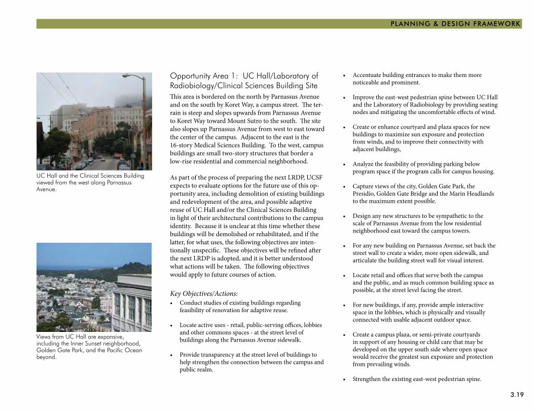
3.19
PLANNING & DESIGN FRAMEWORK
Views from UC Hall are expansive, including the Inner Sunset neighborhood, Golden Gate Park, and the Pacific Ocean beyond.
UC Hall and the Clinical Sciences Building viewed from the west along Parnassus Avenue.
Opportunity Area 1: UC Hall/Laboratory of Radiobiology/Clinical Sciences Building SiteThis area is bordered on the north by Parnassus Avenue and on the south by Koret Way, a campus street. The ter-rain is steep and slopes upwards from Parnassus Avenue to Koret Way toward Mount Sutro to the south. The site also slopes up Parnassus Avenue from west to east toward the center of the campus. Adjacent to the east is the 16-story Medical Sciences Building. To the west, campus buildings are small two-story structures that border a low-rise residential and commercial neighborhood.
As part of the process of preparing the next LRDP, UCSF expects to evaluate options for the future use of this op-portunity area, including demolition of existing buildings and redevelopment of the area, and possible adaptive reuse of UC Hall and/or the Clinical Sciences Building in light of their architectural contributions to the campus identity. Because it is unclear at this time whether these buildings will be demolished or rehabilitated, and if the latter, for what uses, the following objectives are inten-tionally unspecific. These objectives will be refined after the next LRDP is adopted, and it is better understood what actions will be taken. The following objectives would apply to future courses of action.
Key Objectives/Actions:Conduct studies of existing buildings regarding •feasibility of renovation for adaptive reuse.
Locate active uses - retail, public-serving offices, lobbies •and other commons spaces - at the street level of buildings along the Parnassus Avenue sidewalk.
Provide transparency at the street level of buildings to •help strengthen the connection between the campus and public realm.
Accentuate building entrances to make them more •noticeable and prominent.
Improve the east-west pedestrian spine between UC Hall •and the Laboratory of Radiobiology by providing seating nodes and mitigating the uncomfortable effects of wind.
Create or enhance courtyard and plaza spaces for new •buildings to maximize sun exposure and protection from winds, and to improve their connectivity with adjacent buildings,
Analyze the feasibility of providing parking below •program space if the program calls for campus housing.
Capture views of the city, Golden Gate Park, the •Presidio, Golden Gate Bridge and the Marin Headlands to the maximum extent possible.
Design any new structures to be sympathetic to the •scale of Parnassus Avenue from the low residential neighborhood east toward the campus towers.
For any new building on Parnassus Avenue, set back the •street wall to create a wider, more open sidewalk, and articulate the building street wall for visual interest.
Locate retail and offices that serve both the campus •and the public, and as much common building space as possible, at the street level facing the street.
For new buildings, if any, provide ample interactive •space in the lobbies, which is physically and visually connected with usable adjacent outdoor space.
Create a campus plaza, or semi-private courtyards •in support of any housing or child care that may be developed on the upper south side where open space would receive the greatest sun exposure and protection from prevailing winds.
Strengthen the existing east-west pedestrian spine.•
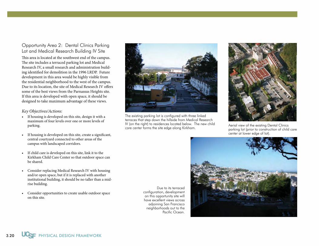
3.20 PHYSICAL DESIGN FRAMEWORK
Opportunity Area 2: Dental Clinics Parking Lot and Medical Research Building IV SiteThis area is located at the southwest end of the campus. The site includes a terraced parking lot and Medical Research IV, a small research and administration build-ing identified for demolition in the 1996 LRDP. Future development in this area would be highly visible from the residential neighborhood to the west of the campus. Due to its location, the site of Medical Research IV offers some of the best views from the Parnassus Heights site. If this area is developed with open space, it should be designed to take maximum advantage of these views.
Key Objectives/Actions:If housing is developed on this site, design it with a •maximum of four levels over one or more levels of parking.
If housing is developed on this site, create a significant, •central courtyard connected to other areas of the campus with landscaped corridors.
If child care is developed on this site, link it to the •Kirkham Child Care Center so that outdoor space can be shared.
Consider replacing Medical Research IV with housing •and/or open space, but if it is replaced with another institutional building, it should be no taller than a mid-rise building.
Consider opportunities to create usable outdoor space •on this site.
Aerial view of the existing Dental Clinics parking lot (prior to construction of child care center at lower edge of lot).
Due to its terraced configuration, development on this opportunity site will have excellent views across
adjoining San Francisco neighborhoods out to the
Pacific Ocean.
The existing parking lot is configured with three linked terraces that step down the hillside from Medical Research IV (on the right) to residences located below. The new child care center forms the site edge along Kirkham.
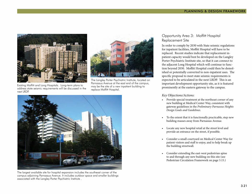
3.21
PLANNING & DESIGN FRAMEWORK
Opportunity Area 3: Moffitt Hospital Replacement SiteIn order to comply by 2030 with State seismic regulations for inpatient facilities, Moffitt Hospital will have to be replaced. Recent studies indicate that replacement in-patient capacity would best be developed on the Langley Porter Psychiatric Institute site, so that it can connect to the adjacent Long Hospital which will continue to func-tion beyond 2030. Moffitt Hospital could then be demol-ished or potentially converted to non-inpatient uses. The specific proposal to meet state seismic requirements is expected to be articulated in the next LRDP. This is an important development opportunity site, as it is featured prominently at the eastern gateway to the campus.
Key Objections/Actions:Provide special treatment at the northeast corner of any •new building at Medical Center Way, consistent with gateway guidelines in the Preliminary Parnassus Heights Design Goals and Guidelines.
To the extent that it is functionally practicable, step new •building masses away from Parnassus Avenue.
Locate any new hospital retail at the street level and •provide an entrance on the street, if possible.
Consider a small courtyard on Medical Center Way for •patient visitors and staff to enjoy, and to help break up the building streetwall.
Consider extending the east-west pedestrian spine •to and through any new building on this site (see Pedestrian Circulation Framework on page 3.15.)
Existing Moffitt and Long Hospitals. Long-term plans to address state seismic requirements will be discussed in the next LRDP.
The largest available site for hospital expansion includes the southeast corner of the campus adjoining Parnassus Avenue. It includes outdoor space and smaller buildings associated with the Langley Porter Psychiatric Institute .
The Langley Porter Psychiatric Institute, located on Parnassus Avenue at the east end of the campus, may be the site of a new inpatient building to replace Moffitt Hospital.
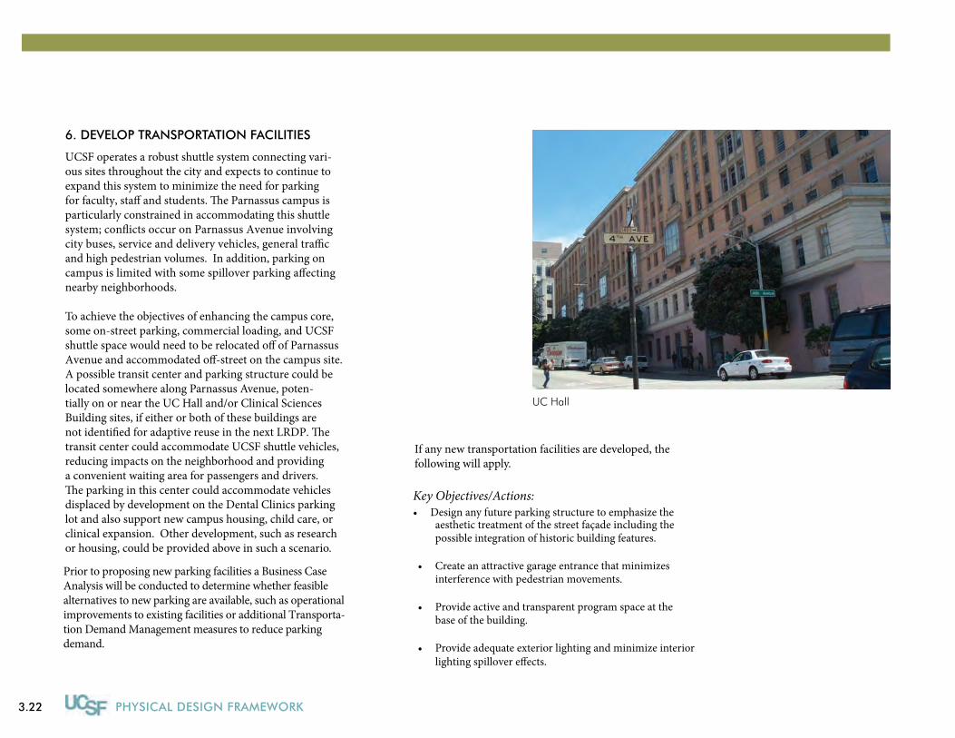
3.22 PHYSICAL DESIGN FRAMEWORK
6. DEVELOP TRANSPORTATION FACILITIES
UCSF operates a robust shuttle system connecting vari-ous sites throughout the city and expects to continue to expand this system to minimize the need for parking for faculty, sta� and students. �e Parnassus campus is particularly constrained in accommodating this shuttlesystem; con�icts occur on Parnassus Avenue involvingcity buses, service and delivery vehicles, general tra�c and high pedestrian volumes. In addition, parking oncampus is limited with some spillover parking a�ectingnearby neighborhoods.
To achieve the objectives of enhancing the campus core, some on-street parking, commercial loading, and UCSF shuttle space would need to be relocated o� of Parnassus Avenue and accommodated o�-street on the campus site. A possible transit center and parking structure could be located somewhere along Parnassus Avenue, poten- tially on or near the UC Hall and/or Clinical Sciences Building sites, if either or both of these buildings arenot identi�ed for adaptive reuse in the next LRDP. �e transit center could accommodate UCSF shuttle vehicles, reducing impacts on the neighborhood and providing a convenient waiting area for passengers and drivers.�e parking in this center could accommodate vehicles displaced by development on the Dental Clinics parking lot and also support new campus housing, child care, or clinical expansion. Other development, such as research or housing, could be provided above in such a scenario.
Key Objectives/Actions:Design any future parking structure to emphasize the •
UC Hall
aesthetic treatment of the street façade including the possible integration of historic building features.
Create an attractive garage entrance that minimizes • interference with pedestrian movements.
Provide active and transparent program space at the • base of the building.
Provide adequate exterior lighting and minimize interiorlighting spillover e�ects.
•
Prior to proposing new parking facilities a Business Case Analysis will be conducted to determine whether feasible alternatives to new parking are available, such as operational improvements to existing facilities or additional Transporta-tion Demand Management measures to reduce parking demand.
If any new transportation facilities are developed, thefollowing will apply.
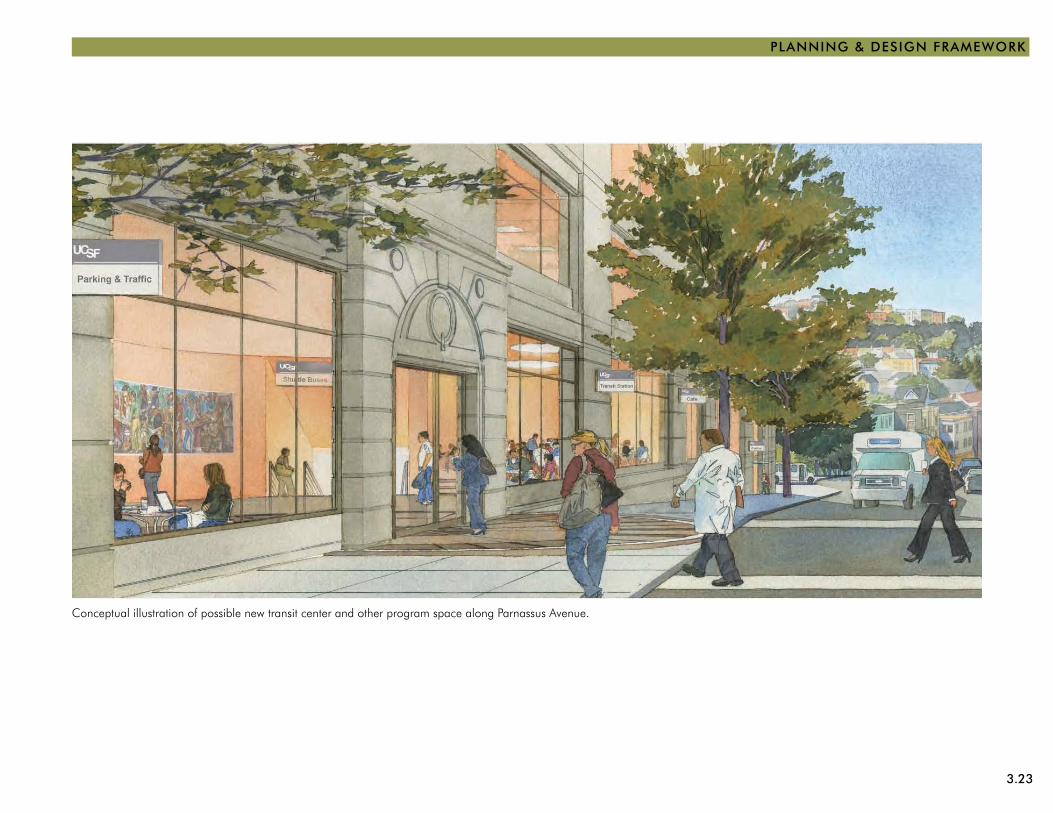
3.23
PLANNING & DESIGN FRAMEWORK
Conceptual illustration of possible new transit center and other program space along Parnassus Avenue.
3.24 PHYSICAL DESIGN FRAMEWORK
MISSION BAY
The 57-acre Mission Bay site is located at the eastern edge of the city and in the center of the 303-acre Mission Bay Redevelopment Area. Located south of downtown San Francisco, the area was originally part of the San Francis-co Bay, but was partially filled with debris from the 1906 earthquake and was used historically as rail transport yards and for industrial uses.
Only partially developed, the UCSF Mission Bay campus now has eight completed projects: four research build-ings, a multi-family residential complex, a community center and two multi-story parking structures, plus a number of developed open spaces. Two additional research buildings are currently under construction. All of these buildings have been constructed within the past decade in accordance with the 1996 LRDP, LRDP amendments and the 1999 Mission Bay Campus Master Plan and Design Guidelines. With limited exceptions, campus buildings have large rectangular footprints, an 85-foot height to the cornice line, a light-colored material palette of two-toned travertine and concrete for the skin, light green tinted glazing, arcades at the ground level and sculptural treatment of the rooftop mechanical equip-ment and exhaust stacks. The William J. Rutter Center which contains conference, fitness and food service facili-ties is the exception, exhibiting a bold color scheme and 144-foot tower to mark the “heart” of the campus. The Mission Bay Campus Master Plan provides generous open space between buildings, a large main green space known as Koret Quad which has already been built, and smaller courtyards on most blocks.
In 2005 and 2007, UCSF acquired additional parcels of land totalling 14.5 acres directly to the south of the
original campus site to develop facilities for the UCSF Medical Center at Mission Bay. This project is expected to be completed by the end of 2014.
The physical development of the Mission Bay Redevel-opment Area surrounding the campus site is governed by the San Francisco Redevelopment Agency (SFRA) and two plans, the Mission Bay Redevelopment Plan and Design for Development, which were approved by the City in November 1998. The plans envision a mixed-use com-munity that would allow 6,090 new multi-family housing units, 4.4 million gsf of commercial-industrial zoned space, 800,000 gsf of retail space and a 500-room hotel. Build-out will provide 49 acres of new public open space, including parks along Mission Creek and San Francisco Bay. The City is currently considering redevelopment op-tions for the adjacent Seawall Lot 337 and Pier 70 areas, which are proposed to be developed with significant additional office space, retail space, entertainment and cultural uses, residential development, additional open space and, in the case of Pier 70, light manufacturing and research and development in addition to existing maritime industry.
The City’s approved Design for Development standards include:
Building variety on a block while maintaining a •consistent street frontage; Buildings built to the street edge with a lively •pedestrian-friendly ground level of residential entries and neighborhood stores; Variety at the street level for pedestrian scale through •the use of special design features and landscaping; Buildings that avoid extreme contrasts in materials, •colors, shapes and other characteristics; and Buildings that are generally 90 feet high with towers up •to 160 feet that are integrated into the overall design of structures.

3.25
PLANNING & DESIGN FRAMEWORK
Mission Bay campus
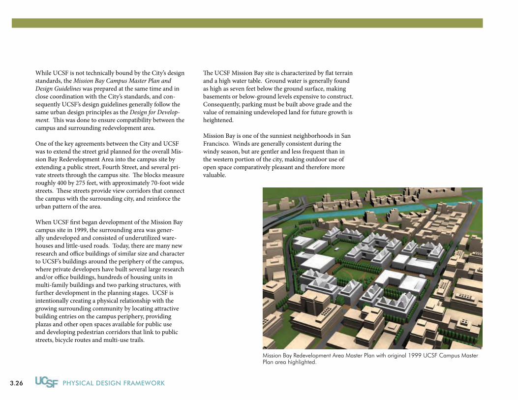
3.26 PHYSICAL DESIGN FRAMEWORK
While UCSF is not technically bound by the City’s design standards, the Mission Bay Campus Master Plan and Design Guidelines was prepared at the same time and in close coordination with the City’s standards, and con-sequently UCSF’s design guidelines generally follow the same urban design principles as the Design for Develop-ment. This was done to ensure compatibility between the campus and surrounding redevelopment area.
One of the key agreements between the City and UCSF was to extend the street grid planned for the overall Mis-sion Bay Redevelopment Area into the campus site by extending a public street, Fourth Street, and several pri-vate streets through the campus site. The blocks measure roughly 400 by 275 feet, with approximately 70-foot wide streets. These streets provide view corridors that connect the campus with the surrounding city, and reinforce the urban pattern of the area.
When UCSF first began development of the Mission Bay campus site in 1999, the surrounding area was gener-ally undeveloped and consisted of underutilized ware-houses and little-used roads. Today, there are many new research and office buildings of similar size and character to UCSF’s buildings around the periphery of the campus, where private developers have built several large research and/or office buildings, hundreds of housing units in multi-family buildings and two parking structures, with further development in the planning stages. UCSF is intentionally creating a physical relationship with the growing surrounding community by locating attractive building entries on the campus periphery, providing plazas and other open spaces available for public use and developing pedestrian corridors that link to public streets, bicycle routes and multi-use trails.
The UCSF Mission Bay site is characterized by flat terrain and a high water table. Ground water is generally found as high as seven feet below the ground surface, making basements or below-ground levels expensive to construct. Consequently, parking must be built above grade and the value of remaining undeveloped land for future growth is heightened. Mission Bay is one of the sunniest neighborhoods in San Francisco. Winds are generally consistent during the windy season, but are gentler and less frequent than in the western portion of the city, making outdoor use of open space comparatively pleasant and therefore more valuable.
Mission Bay Redevelopment Area Master Plan with original 1999 UCSF Campus Master Plan area highlighted.
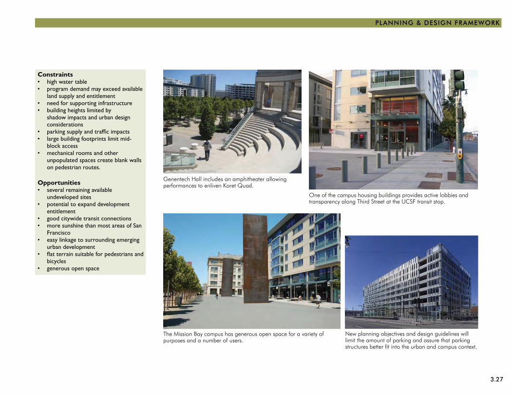
3.27
PLANNING & DESIGN FRAMEWORK
Genentech Hall includes an amphitheater allowing performances to enliven Koret Quad.
The Mission Bay campus has generous open space for a variety of purposes and a number of users.
New planning objectives and design guidelines will limit the amount of parking and assure that parking structures better fit into the urban and campus context.
One of the campus housing buildings provides active lobbies and transparency along Third Street at the UCSF transit stop.
Constraintshigh water table • program demand may exceed available • land supply and entitlementneed for supporting infrastructure• building heights limited by • shadow impacts and urban design considerationsparking supply and traffic impacts• large building footprints limit mid-• block accessmechanical rooms and other • unpopulated spaces create blank walls on pedestrian routes.
Opportunitiesseveral remaining available • undeveloped sitespotential to expand development • entitlementgood citywide transit connections• more sunshine than most areas of San • Franciscoeasy linkage to surrounding emerging • urban developmentflat terrain suitable for pedestrians and • bicyclesgenerous open space•
3.28 PHYSICAL DESIGN FRAMEWORK
StRAtEGIES
The following section describes six strategies for imple-menting the universal planning and design principles and guidelines at Mission Bay. Although strategies are similar to those for the Parnassus Heights campus site, the specific actions will be different. Action plans to implement these strategies are currently being prepared.
These strategies flow directly from the six universal plan-ning and design principles. By strengthening UCSF’s identity and wayfinding with new, comprehensive signage, UCSF will be responding to CONTEXT while reinforcing its identity, welcoming the COMMUNITY, ensuring CONNECTIVITY and improving COHESIVE-NESS. Enhancing the campus core will be achieved by applying all of these principles, in addition to creating a space that promotes COLLEGIALITY. The same is true for enhancing the pedestrian experience and expand-ing the open space network, for which leading through CONSERVATION and sustainability will also apply. When developing opportunity areas, which will consist of buildings and open space, all six of the principles will be applicable. If transportation facilities are sited and designed according to the objectives in Section 6, all the principles will also be relevant.
The six planning and design strategies for Mission Bay include the following:
Strengthen UCSF’s Identity and Wayfinding1. As with all UCSF campuses, creating a consistent and readily identifiable identity is challenging. While the Mission Bay campus is designed to integrate with the surrounding, emerging urban context, a variety of design efforts, from architectural elements to signage will help identify the campus and assist wayfinding.
Enhance the Pedestrian Experience 2. The Mission Bay campus already has a strong pedestrian framework in place predicated on the grid of streets that serves the entire redevelopment area. Future efforts will focus on enhancing the quality of that environment.
Complete the Open Space Network3. Several large open space areas at Mission Bay have been developed, but several additional open space areas remain to be designed and constructed, including planned recreational facilities.
Enhance the Campus Core4. A major green space at the center of the campus, called for in the Mission Bay Master Plan and Design Guidelines, has been implemented as Koret Quad, but some consider it inadequate for meeting outdoor informal recreational needs. Improvements to this Mission Bay campus core, focused on the area of Koret Quad but also including the plaza and walkways, will be explored.
Develop Opportunity Areas5. There are several remaining undeveloped sites on the Mission Bay campus. With over 70 percent of the development entitlement already built or planned, a study is underway to determine the development capacity of these sites and to ensure that new buildings complement existing development.
Develop Transportation Facilities6. Parking facilities design is of concern in the Mission Bay area, where several parking structures remain to be built. The community and City are concerned that UCSF site and design future parking structures to be attractive on all sides and appropriate for the setting. UCSF will continue to pursue strategies to reduce parking demand and integrate parking into the campus more successfully.

3.29
PLANNING & DESIGN FRAMEWORK
Framework Plan for UCSF Mission Bay showing built and currently planned campus site with the addition of Phases I and 2 of the new UCSF Medical Center at Mission Bay and supporting parking.
OWENS STREET
WOMEN’S ANDCANCER HOSPITALS
FUTUREMARIPOSA
PARK(CITY)
FUTUREHOSPITALBUILDING
GENENTECHHALL
KORET QUAD
RUTTERCENTER
I-280 (ELEVATED)
SAN FRANCISCOUNIFIED SCHOOL
DISTRICTCENTRALUTILITYPLANT
CARDIO-VASCULARRESEARCH
HELENDILLERCANCER
RESEARCH
HOUSING
MISSION BAY COMMONS(CITY)
I-280 (ELEVATED)
I-280 (ELEVATED)
NEURO-SCIENCES
ROCKHALL
MISSION CR
EEK P
ARKS
BYERSHALL
P
PP
P
P
P P
COURTS
SPORTSFIELD
PLAZA
HEA
RST
CMTYCTR
GARAGETHIRD STGARAGE
OUTPATIENTBUILDING
CANCEROUTPATIENTBUILDING
ENERGYCENTER
CHILDREN’SHOSPITAL
1500OWENS
GLADSTONEINSTITUTES
SIXTEENTH STREET
THIR
D ST
REET
FOU
RTH
STR
EET
OW
ENS
STRE
ET
MARIPOSA STREET
MISSION BAY BOULEVARD SOUTH
NELSON RISING LANE
GENE FRIEND WAY
THIR
D ST
REET
FOU
RTH
STR
EET
SIXT
H S
TREE
T
FIFT
H S
TREE
TCAMPUS WAY
MISSION BAY BOULEVARD NORTH
CHINA BASIN STREET
MISSION ROCK STREET
CHINA BASIN STREET
LONG BR
IDGE S
TREE
T
CHAN
NEL ST
REET
ILLI
NO
IS S
TREE
T
SIXTEENTH STREET
TERR
Y FR
ANCO
IS S
TREE
T
TERR
Y FR
ANCO
IS ST
REET
BRID
GEV
IEW
WAY
SOUTH STREET
CAMPUS WAY
BRID
GEV
IEW
WAY
North
KORET QUAD
MAJOR ENTRIES AND GATEWAYS
MAJOR VEHICULAR CAMPUS CONNECTOR
LEGEND
UCSF CAMPUS BOUNDARY
MINOR ENTRIES AND GATEWAYS
CAMPUS CORE
MAJOR PEDESTRIAN CAMPUS CONNECTOR
STREETS
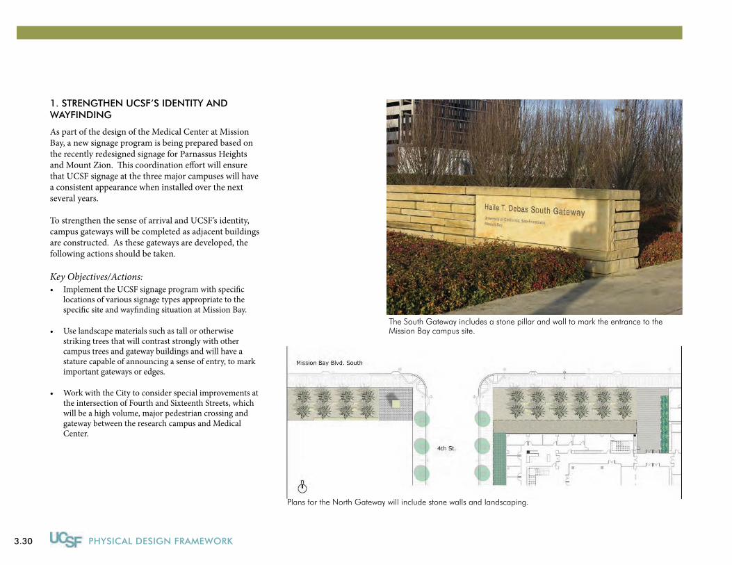
3.30 PHYSICAL DESIGN FRAMEWORK
1. StRENGtHEN UCSF’S IDENtItY AND WAYFINDING
As part of the design of the Medical Center at Mission Bay, a new signage program is being prepared based on the recently redesigned signage for Parnassus Heights and Mount Zion. This coordination effort will ensure that UCSF signage at the three major campuses will have a consistent appearance when installed over the next several years.
To strengthen the sense of arrival and UCSF’s identity, campus gateways will be completed as adjacent buildings are constructed. As these gateways are developed, the following actions should be taken.
Key Objectives/Actions:Implement the UCSF signage program with specific •locations of various signage types appropriate to the specific site and wayfinding situation at Mission Bay.
Use landscape materials such as tall or otherwise •striking trees that will contrast strongly with other campus trees and gateway buildings and will have a stature capable of announcing a sense of entry, to mark important gateways or edges.
Work with the City to consider special improvements at •the intersection of Fourth and Sixteenth Streets, which will be a high volume, major pedestrian crossing and gateway between the research campus and Medical Center.
The South Gateway includes a stone pillar and wall to mark the entrance to the Mission Bay campus site.
Plans for the North Gateway will include stone walls and landscaping.
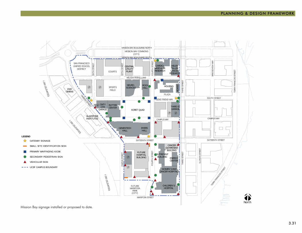
3.31
PLANNING & DESIGN FRAMEWORK
Mission Bay signage installed or proposed to date.
OWENS STREET
WOMEN’S ANDCANCER HOSPITALS
FUTUREMARIPOSA
PARK(CITY)
FUTUREHOSPITALBUILDING
GENENTECHHALL
KORET QUAD
RUTTERCENTER
I-280 (ELEVATED)
SAN FRANCISCOUNIFIED SCHOOL
DISTRICTCENTRALUTILITYPLANT
CARDIO-VASCULARRESEARCH
HELENDILLERCANCER
RESEARCH
HOUSING
MISSION BAY COMMONS(CITY)
I-280 (ELEVATED)
I-280 (ELEVATED)
NEURO-SCIENCES
ROCKHALL
MISSION CR
EEK P
ARKS
BYERSHALL
P
PP
P
P
P P
COURTS
SPORTSFIELD
PLAZA
HEA
RST
CMTYCTR
GARAGETHIRD STGARAGE
OUTPATIENTBUILDING
CANCEROUTPATIENTBUILDING
ENERGYCENTER
CHILDREN’SHOSPITAL
1500OWENS
GLADSTONEINSTITUTES
SIXTEENTH STREET
THIR
D ST
REET
FOU
RTH
STR
EET
OW
ENS
STRE
ET
MARIPOSA STREET
MISSION BAY BOULEVARD SOUTH
NELSON RISING LANE
GENE FRIEND WAY
THIR
D ST
REET
FOU
RTH
STR
EET
SIXT
H S
TREE
T
FIFT
H S
TREE
TCAMPUS WAY
MISSION BAY BOULEVARD NORTH
CHINA BASIN STREET
MISSION ROCK STREET
CHINA BASIN STREET
LONG BR
IDGE S
TREE
T
CHAN
NEL ST
REET
ILLI
NO
IS S
TREE
T
SIXTEENTH STREET
TERR
Y FR
ANCO
IS S
TREE
T
TERR
Y FR
ANCO
IS ST
REET
BRID
GEV
IEW
WAY
SOUTH STREET
CAMPUS WAY
BRID
GEV
IEW
WAY
North
LEGEND
PRIMARY WAYFINDING KIOSK
SECONDARY PEDESTRIAN SIGN
VEHICULAR SIGN
UCSF CAMPUS BOUNDARY
GATEWAY SIGNAGE
SMALL SITE IDENTIFICATION SIGN
3.32 PHYSICAL DESIGN FRAMEWORK
2. ENHANCE tHE CAMPUS CORE
The core of the Mission Bay campus site is Koret Quad, which has been fully developed as a large grassy green with trees and seating. The William J. Rutter Center faces the Quad and provides a nearby cafe and some outdoor seating. However, concerns have been expressed that the quad does not lend itself to informal recreation and is not adequately usable.
Key Objectives/Actions:Consider modifying the western lawn to make it level •and more conducive to informal play.
Consider removing some of the evergreen trees to •improve visibility of the quad from the surrounding buildings and pedestrian walkways, reduce shade and provide more space for the remaining trees.
Open Space Evergreens
Koret Quad includes a raised lawn area or berm planted with trees; the berm creates a visual and physical separation from the pedestrian walkway and isolates the activities of the core.
The William J. Rutter Center faces Koret Quad and provides active recreation facilities such as a swimming pool and climbing wall, a cafe and outdoor seating. Plans to further activate the Quad and core area are being studied.
3.33
PLANNING & DESIGN FRAMEWORK
Koret Quad includes mounded lawn areas and dense tree plantings; the lack of flat, sunny areas limits opportunities for informal recreation.
The pedestrian walkway from Fourth Street along Campus Way leads to the William J. Rutter Center and research facilities.
3.34 PHYSICAL DESIGN FRAMEWORK
3. ENHANCE tHE PEDEStRIAN ExPERIENCE
At Mission Bay, pedestrian connectivity is being accom-plished incrementally through the implementation of the Mission Bay Master Plan and Design Guidelines. Many of the universal planning and design guidelines that address the pedestrian experience in the public realm, such as special architectural treatment of the street frontages and the provision of public uses and amenities at the street, are also applicable.
Key Objectives/Actions:Work with the City to ensure safe pedestrian crossing •of public streets through use of special materials and other traffic calming features, especially at Fourth and Sixteenth Streets where pedestrian volumes leading to and from the future Medical Center are expected to be high.
Provide adequate amenities in pedestrian areas •consistent with likely use and scale.
Locate active uses such as food service and building •entries and lobbies along pedestrian routes to provide easy access.
Design building bases and entrances to be especially •visually interesting and inviting.
Consider the redesign of some pedestrian spaces that are •overscaled or inadequately used.
Place shuttle stops at convenient locations and provide •shelters and seating.
Active uses located in the ground floor of campus housing help enliven the pedestrian realm.
Activities, such as a farmer’s market, add interest to the plaza for Mission Bay faculty, staff and students.
The pedestrian crossing at Fourth Street and Gene Friend Way is clearly marked with special paving.
3.35
PLANNING & DESIGN FRAMEWORK
OWENS STREET
WOMEN’S ANDCANCER HOSPITALS
FUTUREMARIPOSA
PARK(CITY)
FUTUREHOSPITALBUILDING
GENENTECHHALL
KORET QUAD
RUTTERCENTER
I-280 (ELEVATED)
SAN FRANCISCOUNIFIED SCHOOL
DISTRICTCENTRALUTILITYPLANT
CARDIO-VASCULARRESEARCH
HELENDILLERCANCER
RESEARCH
HOUSING
MISSION BAY COMMONS(CITY)
I-280 (ELEVATED)
I-280 (ELEVATED)
NEURO-SCIENCES
ROCKHALL
MISSION CR
EEK P
ARKS
BYERSHALL
P
PP
P
P
P P
COURTS
SPORTSFIELD
PLAZA
HEA
RST
CMTYCTR
GARAGETHIRD STGARAGE
OUTPATIENTBUILDING
CANCEROUTPATIENTBUILDING
ENERGYCENTER
CHILDREN’SHOSPITAL
1500OWENS
GLADSTONEINSTITUTES
SIXTEENTH STREET
THIR
D ST
REET
FOU
RTH
STR
EET
OW
ENS
STRE
ET
MARIPOSA STREET
MISSION BAY BOULEVARD SOUTH
NELSON RISING LANE
GENE FRIEND WAY
THIR
D ST
REET
FOU
RTH
STR
EET
SIXT
H S
TREE
T
FIFT
H S
TREE
TCAMPUS WAY
MISSION BAY BOULEVARD NORTH
CHINA BASIN STREET
MISSION ROCK STREET
CHINA BASIN STREET
LONG BR
IDGE S
TREE
T
CHAN
NEL ST
REET
ILLI
NO
IS S
TREE
T
SIXTEENTH STREET
TERR
Y FR
ANCO
IS S
TREE
T
TERR
Y FR
ANCO
IS ST
REET
BRID
GEV
IEW
WAY
SOUTH STREET
CAMPUS WAY
BRID
GEV
IEW
WAY
North
LEGEND
EXISTING PRIMARY PEDESTRIAN CORRIDOR
OPEN SPACE
POTENTIAL FUTURE PEDESTRIAN MOVEMENT
T EXISTING THIRD STREET LIGHT RAIL STOP
SIGNALIZED INTERSECTION (EXISTING AND FUTURE)
UCSF CAMPUS BOUNDARY
POTENTIAL INTERSECTION IMPROVEMENT OPPORTUNITY
T
T
T
T
Pedestrian Framework
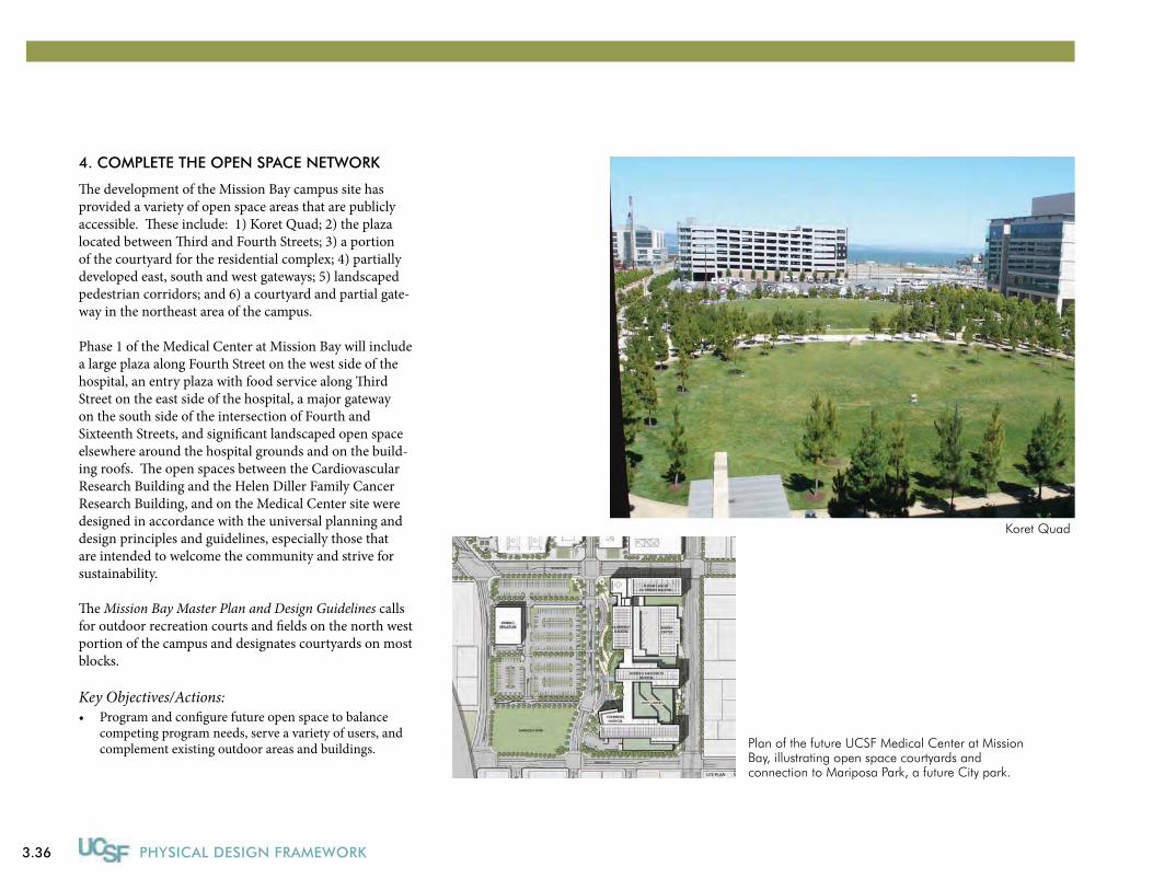
3.36 PHYSICAL DESIGN FRAMEWORK
4. COMPLEtE tHE OPEN SPACE NEtWORK
The development of the Mission Bay campus site has provided a variety of open space areas that are publicly accessible. These include: 1) Koret Quad; 2) the plaza located between Third and Fourth Streets; 3) a portion of the courtyard for the residential complex; 4) partially developed east, south and west gateways; 5) landscaped pedestrian corridors; and 6) a courtyard and partial gate-way in the northeast area of the campus.
Phase 1 of the Medical Center at Mission Bay will include a large plaza along Fourth Street on the west side of the hospital, an entry plaza with food service along Third Street on the east side of the hospital, a major gateway on the south side of the intersection of Fourth and Sixteenth Streets, and significant landscaped open space elsewhere around the hospital grounds and on the build-ing roofs. The open spaces between the Cardiovascular Research Building and the Helen Diller Family Cancer Research Building, and on the Medical Center site were designed in accordance with the universal planning and design principles and guidelines, especially those that are intended to welcome the community and strive for sustainability.
The Mission Bay Master Plan and Design Guidelines calls for outdoor recreation courts and fields on the north west portion of the campus and designates courtyards on most blocks.
Key Objectives/Actions:Program and configure future open space to balance •competing program needs, serve a variety of users, and complement existing outdoor areas and buildings.
Koret Quad
Plan of the future UCSF Medical Center at Mission Bay, illustrating open space courtyards and connection to Mariposa Park, a future City park.
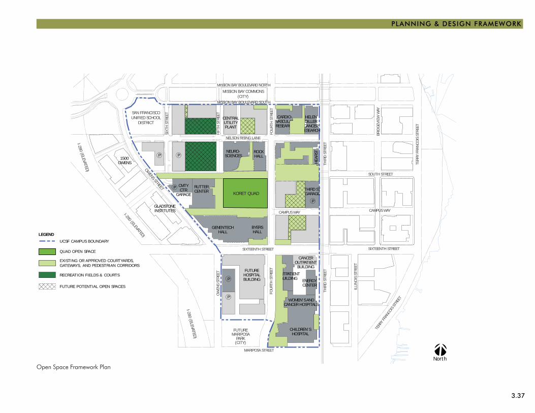
3.37
PLANNING & DESIGN FRAMEWORK
Open Space Framework Plan
OWENS STREET
WOMEN’S ANDCANCER HOSPITALS
FUTUREMARIPOSA
PARK(CITY)
FUTUREHOSPITALBUILDING
GENENTECHHALL
KORET QUAD
RUTTERCENTER
I-280 (ELEVATED)
SAN FRANCISCOUNIFIED SCHOOL
DISTRICTCENTRALUTILITYPLANT
CARDIO-VASCULARRESEARCH
HELENDILLERCANCER
RESEARCH
HOUSING
MISSION BAY COMMONS(CITY)
I-280 (ELEVATED)
I-280 (ELEVATED)
NEURO-SCIENCES
ROCKHALL
MISSION CR
EEK P
ARKS
BYERSHALL
P
PP
P
P
P P
COURTS
SPORTSFIELD
PLAZA
HEA
RST
CMTYCTR
GARAGETHIRD STGARAGE
OUTPATIENTBUILDING
CANCEROUTPATIENTBUILDING
ENERGYCENTER
CHILDREN’SHOSPITAL
1500OWENS
GLADSTONEINSTITUTES
SIXTEENTH STREET
THIR
D ST
REET
FOU
RTH
STR
EET
OW
ENS
STRE
ET
MARIPOSA STREET
MISSION BAY BOULEVARD SOUTH
NELSON RISING LANE
GENE FRIEND WAY
THIR
D ST
REET
FOU
RTH
STR
EET
SIXT
H S
TREE
T
FIFT
H S
TREE
TCAMPUS WAY
MISSION BAY BOULEVARD NORTH
CHINA BASIN STREET
MISSION ROCK STREET
CHINA BASIN STREET
LONG BR
IDGE S
TREE
T
CHAN
NEL ST
REET
ILLI
NO
IS S
TREE
T
SIXTEENTH STREET
TERR
Y FR
ANCO
IS S
TREE
T
TERR
Y FR
ANCO
IS ST
REET
BRID
GEV
IEW
WAY
SOUTH STREET
CAMPUS WAY
BRID
GEV
IEW
WAY
North
QUAD OPEN SPACE
EXISTING OR APPROVED COURTYARDS,GATEWAYS, AND PEDESTRIAN CORRIDORS
RECREATION FIELDS & COURTS
LEGEND
UCSF CAMPUS BOUNDARY
FUTURE POTENTIAL OPEN SPACES
KORET QUAD
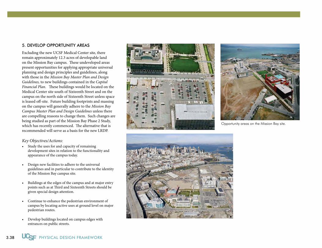
3.38 PHYSICAL DESIGN FRAMEWORK
5. DEVELOP OPPORtUNItY AREAS
Excluding the new UCSF Medical Center site, there remain approximately 12.3 acres of developable land on the Mission Bay campus. These undeveloped areas present opportunities for applying appropriate universal planning and design principles and guidelines, along with those in the Mission Bay Master Plan and Design Guidelines, to new buildings contained in the Capital Financial Plan. These buildings would be located on the Medical Center site south of Sixteenth Street and on the campus on the north side of Sixteenth Street unless space is leased off-site. Future building footprints and massing on the campus will generally adhere to the Mission Bay Campus Master Plan and Design Guidelines unless there are compelling reasons to change them. Such changes are being studied as part of the Mission Bay Phase 2 Study, which has recently commenced. The alternative that is recommended will serve as a basis for the new LRDP.
Key Objectives/Actions:Study the uses for and capacity of remaining •development sites in relation to the functionality and appearance of the campus today.
Design new facilities to adhere to the universal •guidelines and in particular to contribute to the identity of the Mission Bay campus site.
Buildings at the edges of the campus and at major entry •points such as at Third and Sixteenth Streets should be given special design attention.
Continue to enhance the pedestrian environment of •campus by locating active uses at ground level on major pedestrian routes.
Develop buildings located on campus edges with •entrances on public streets.
Opportunity areas on the Mission Bay site.
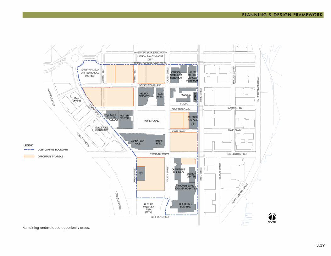
3.39
PLANNING & DESIGN FRAMEWORK
Remaining undeveloped opportunity areas.
OWENS STREET
WOMEN’S ANDCANCER HOSPITALS
FUTUREMARIPOSA
PARK(CITY)
GENENTECHHALL
KORET QUAD
RUTTERCENTER
I-280 (ELEVATED)
SAN FRANCISCOUNIFIED SCHOOL
DISTRICTCARDIO-
VASCULARRESEARCH
HELENDILLERCANCER
RESEARCH
HOUSING
MISSION BAY COMMONS(CITY)
I-280 (ELEVATED)
I-280 (ELEVATED)
NEURO-SCIENCES
ROCKHALL
MISSION CR
EEK P
ARKS
BYERSHALL
P
P
P
PLAZA
HEA
RST
CMTYCTR
GARAGETHIRD STGARAGE
OUTPATIENTBUILDING ENERGY
CENTER
CHILDREN’SHOSPITAL
1500OWENS
GLADSTONEINSTITUTES
SIXTEENTH STREET
THIR
D ST
REET
FOU
RTH
STR
EET
OW
ENS
STRE
ET
MARIPOSA STREET
MISSION BAY BOULEVARD SOUTH
NELSON RISING LANE
GENE FRIEND WAY
THIR
D ST
REET
FOU
RTH
STR
EET
SIXT
H S
TREE
T
FIFT
H S
TREE
TCAMPUS WAY
MISSION BAY BOULEVARD NORTH
CHINA BASIN STREET
MISSION ROCK STREET
CHINA BASIN STREET
LONG BR
IDGE S
TREE
T
CHAN
NEL ST
REET
ILLI
NO
IS S
TREE
T
SIXTEENTH STREET
TERR
Y FR
ANCO
IS S
TREE
T
TERR
Y FR
ANCO
IS ST
REET
BRID
GEV
IEW
WAY
SOUTH STREET
CAMPUS WAY
BRID
GEV
IEW
WAY
North
LEGEND
OPPORTUNITY AREAS
UCSF CAMPUS BOUNDARY
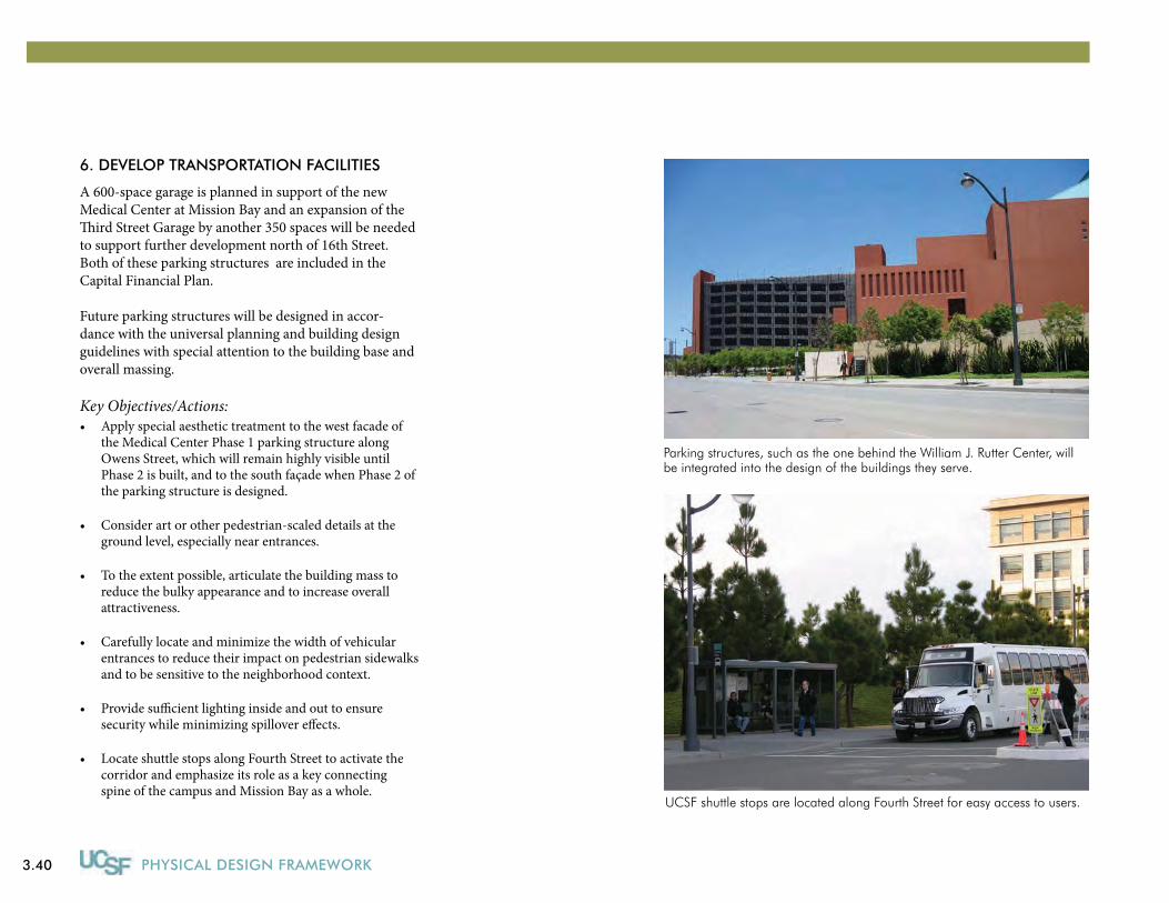
3.40 PHYSICAL DESIGN FRAMEWORK
6. DEVELOP tRANSPORtAtION FACILItIES
A 600-space garage is planned in support of the new Medical Center at Mission Bay and an expansion of the Third Street Garage by another 350 spaces will be needed to support further development north of 16th Street. Both of these parking structures are included in the Capital Financial Plan.
Future parking structures will be designed in accor-dance with the universal planning and building design guidelines with special attention to the building base and overall massing.
Key Objectives/Actions:Apply special aesthetic treatment to the west facade of •the Medical Center Phase 1 parking structure along Owens Street, which will remain highly visible until Phase 2 is built, and to the south façade when Phase 2 of the parking structure is designed.
Consider art or other pedestrian-scaled details at the •ground level, especially near entrances.
To the extent possible, articulate the building mass to •reduce the bulky appearance and to increase overall attractiveness.
Carefully locate and minimize the width of vehicular •entrances to reduce their impact on pedestrian sidewalks and to be sensitive to the neighborhood context.
Provide sufficient lighting inside and out to ensure •security while minimizing spillover effects.
Locate shuttle stops along Fourth Street to activate the •corridor and emphasize its role as a key connecting spine of the campus and Mission Bay as a whole.
UCSF shuttle stops are located along Fourth Street for easy access to users.
Parking structures, such as the one behind the William J. Rutter Center, will be integrated into the design of the buildings they serve.
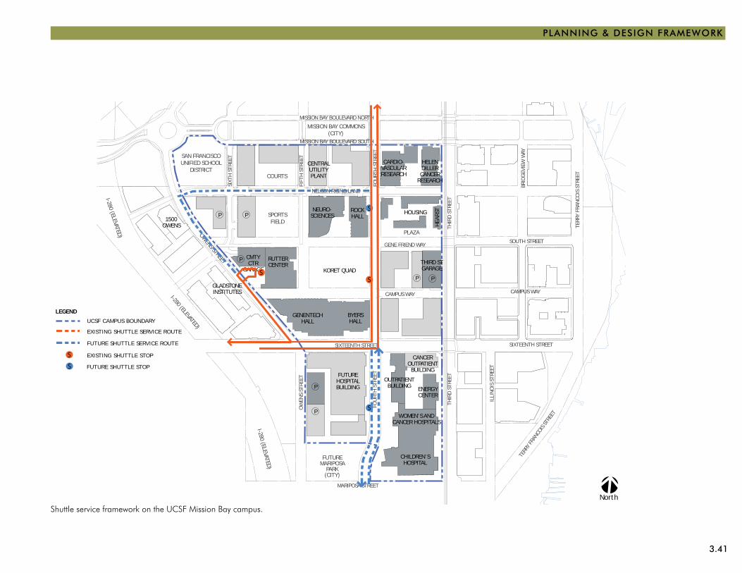
3.41
PLANNING & DESIGN FRAMEWORK
Shuttle service framework on the UCSF Mission Bay campus.
OWENS STREET
WOMEN’S ANDCANCER HOSPITALS
FUTUREMARIPOSA
PARK(CITY)
FUTUREHOSPITALBUILDING
GENENTECHHALL
KORET QUAD
RUTTERCENTER
I-280 (ELEVATED)
SAN FRANCISCOUNIFIED SCHOOL
DISTRICTCENTRALUTILITYPLANT
CARDIO-VASCULARRESEARCH
HELENDILLERCANCER
RESEARCH
HOUSING
MISSION BAY COMMONS(CITY)
I-280 (ELEVATED)
I-280 (ELEVATED)
NEURO-SCIENCES
ROCKHALL
MISSION CR
EEK P
ARKS
BYERSHALL
P
PP
P
P
P P
COURTS
SPORTSFIELD
PLAZA
HEA
RST
CMTYCTR
GARAGETHIRD STGARAGE
OUTPATIENTBUILDING
CANCEROUTPATIENTBUILDING
ENERGYCENTER
CHILDREN’SHOSPITAL
1500OWENS
GLADSTONEINSTITUTES
SIXTEENTH STREET
THIR
D ST
REET
FOU
RTH
STR
EET
OW
ENS
STRE
ET
MARIPOSA STREET
MISSION BAY BOULEVARD SOUTH
NELSON RISING LANE
GENE FRIEND WAY
THIR
D ST
REET
FOU
RTH
STR
EET
SIXT
H S
TREE
T
FIFT
H S
TREE
TCAMPUS WAY
MISSION BAY BOULEVARD NORTH
CHINA BASIN STREET
MISSION ROCK STREET
CHINA BASIN STREET
LONG BR
IDGE S
TREE
T
CHAN
NEL ST
REET
ILLI
NO
IS S
TREE
T
SIXTEENTH STREET
TERR
Y FR
ANCO
IS S
TREE
T
TERR
Y FR
ANCO
IS ST
REET
BRID
GEV
IEW
WAY
SOUTH STREET
CAMPUS WAY
BRID
GEV
IEW
WAY
North
S
S
LEGEND
EXISTING SHUTTLE SERVICE ROUTE
UCSF CAMPUS BOUNDARY
FUTURE SHUTTLE SERVICE ROUTE
FUTURE SHUTTLE STOP
EXISTING SHUTTLE STOP S
S
SS
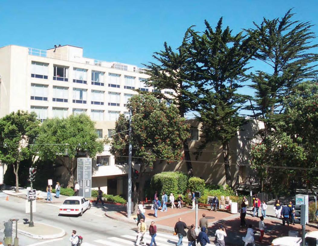
3.42
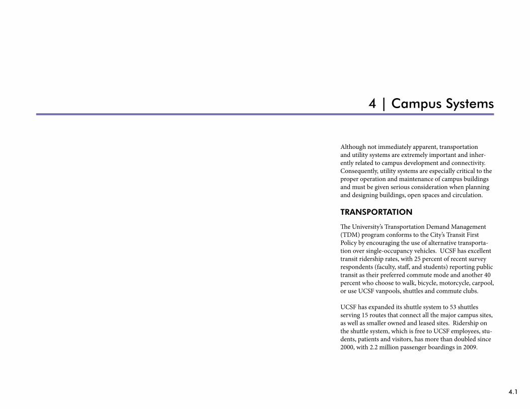
4.1
4 | Campus Systems
Although not immediately apparent, transportation and utility systems are extremely important and inher-ently related to campus development and connectivity. Consequently, utility systems are especially critical to the proper operation and maintenance of campus buildings and must be given serious consideration when planning and designing buildings, open spaces and circulation.
TRANSPORTATION
The University’s Transportation Demand Management (TDM) program conforms to the City’s Transit First Policy by encouraging the use of alternative transporta-tion over single-occupancy vehicles. UCSF has excellent transit ridership rates, with 25 percent of recent survey respondents (faculty, staff, and students) reporting public transit as their preferred commute mode and another 40 percent who choose to walk, bicycle, motorcycle, carpool, or use UCSF vanpools, shuttles and commute clubs.
UCSF has expanded its shuttle system to 53 shuttles serving 15 routes that connect all the major campus sites, as well as smaller owned and leased sites. Ridership on the shuttle system, which is free to UCSF employees, stu-dents, patients and visitors, has more than doubled since 2000, with 2.2 million passenger boardings in 2009.
4.2 PHYSICAL DESIGN FRAMEWORK
The University also supplies two electric vehicle charg-ing stations, and 15 percent of campus fleet vehicles are powered by alternative fuel or a hybrid electric and gas. UCSF provides over 100 off-street motorcycle parking stalls.
In support of bicycling, there are now 53 shuttle-mount-ed bike racks, and the number of bicycle racks on campus sites has been expanded from 400 spaces just five years ago to 680 today. While there are no designated bicycle paths on campus sites, public streets through the Parnas-sus Heights and Mission Bay sites are designated as city bicycle routes.
Future campus development will require expansion of the shuttle system, bicycle use and other TDM opportunities.
Key Objectives / Actions:Continue to coordinate with the City to install •directional signage to UCSF sites.
Provide secure bicycle racks, shuttle shelters and •other alternative and transit support facilities as new buildings and open space are developed.
Continue to coordinate with the City in •implementing wayfinding elements in public sidewalks at Parnassus Heights and Mount Zion.
Work with the City to plan and implement future •gateway and campus core improvements in the public rights-of-way at Parnassus Heights.
Continue to work with the City to establish curb •striping plans and implement pedestrian crossing improvements at all campus sites.
Coordinate with the local public transit agency to •include routes to and stops at major campus sites.
Coordinate with the local transit agency to use •designated City-owned bus stops and bus-only lanes for shuttle access.
Provide a menu of alternative commuting/•transportation options at all major campus sites and locations including vanpool, carpool, car share, rideshare matching and on-site transit pass sales.
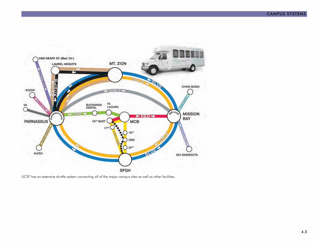
4.3
CAMPUS SYStEMS
UCSF has an extensive shuttle system connecting all of the major campus sites as well as other facilities.
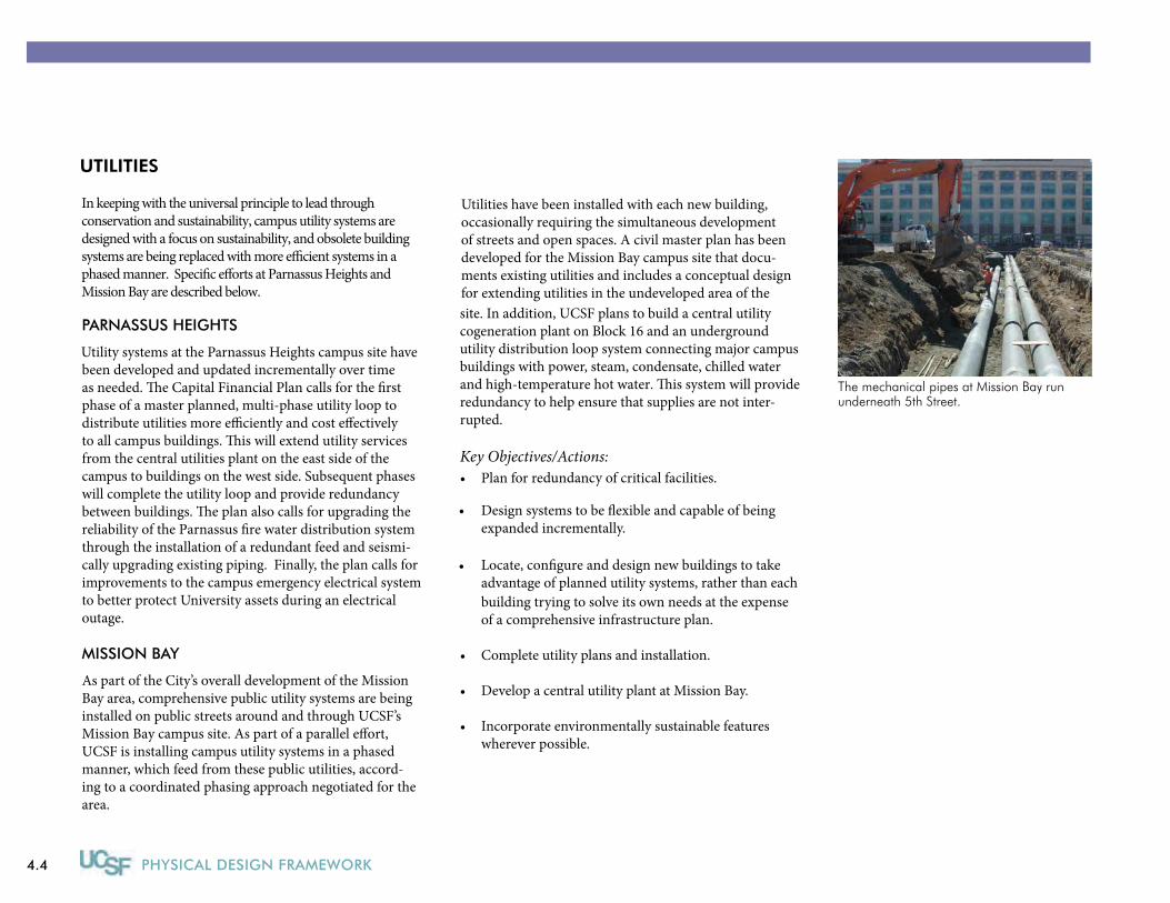
4.4 PHYSICAL DESIGN FRAMEWORK
UTILITIES
PARNASSUS HEIGHTS
Utility systems at the Parnassus Heights campus site have been developed and updated incrementally over timeas needed. �e Capital Financial Plan calls for the �rst phase of a master planned, multi-phase utility loop todistribute utilities more e�ciently and cost e�ectively to all campus buildings. �is will extend utility services from the central utilities plant on the east side of the campus to buildings on the west side. Subsequent phases will complete the utility loop and provide redundancybetween buildings. �e plan also calls for upgrading the reliability of the Parnassus �re water distribution system through the installation of a redundant feed and seismi-cally upgrading existing piping. Finally, the plan calls for improvements to the campus emergency electrical system to better protect University assets during an electrical outage.
MISSION BAY
As part of the City’s overall development of the Mission Bay area, comprehensive public utility systems are being installed on public streets around and through UCSF’sMission Bay campus site. As part of a parallel e�ort, UCSF is installing campus utility systems in a phased manner, which feed from these public utilities, accord-ing to a coordinated phasing approach negotiated for the area.
Utilities have been installed with each new building, occasionally requiring the simultaneous development of streets and open spaces. A civil master plan has been developed for the Mission Bay campus site that docu-ments existing utilities and includes a conceptual design for extending utilities in the undeveloped area of the site. In addition, UCSF plans to build a central utility cogeneration plant on Block 16 and an underground utility distribution loop system connecting major campus buildings with power, steam, condensate, chilled waterand high-temperature hot water. �is system will provide redundancy to help ensure that supplies are not inter-rupted.
Key Objectives/Actions:Plan for redundancy of critical facilities. •
Design systems to be �exible and capable of beingexpanded incrementally.
Locate, con�gure and design new buildings to takeadvantage of planned utility systems, rather than each building trying to solve its own needs at the expense of a comprehensive infrastructure plan.
Complete utility plans and installation. •
Develop a central utility plant at Mission Bay. •
Incorporate environmentally sustainable features • wherever possible.
The mechanical pipes at Mission Bay run underneath 5th Street.
In keeping with the universal principle to lead through conservation and sustainability, campus utility systems are designed with a focus on sustainability, and obsolete building systems are being replaced with more e�cient systems in a phased manner. Speci�c e�orts at Parnassus Heights and Mission Bay are described below.
•
•
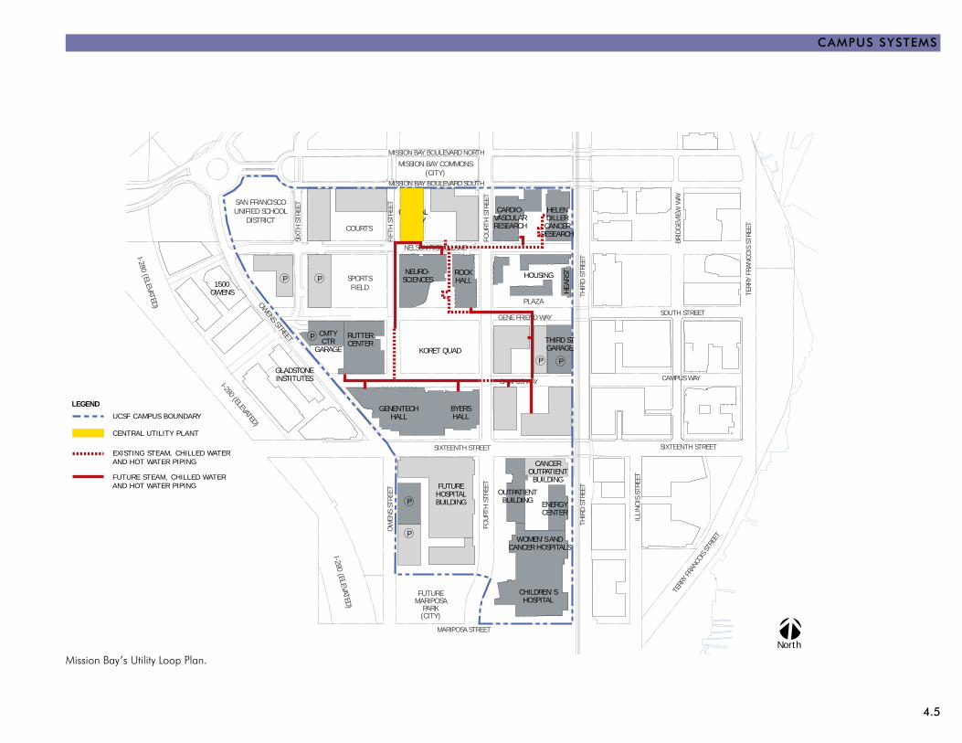
4.5
CAMPUS SYStEMS
Mission Bay’s Utility Loop Plan.
OWENS STREET
WOMEN’S ANDCANCER HOSPITALS
FUTUREMARIPOSA
PARK(CITY)
FUTUREHOSPITALBUILDING
GENENTECHHALL
KORET QUAD
RUTTERCENTER
I-280 (ELEVATED)
SAN FRANCISCOUNIFIED SCHOOL
DISTRICTCENTRALUTILITYPLANT
CARDIO-VASCULARRESEARCH
HELENDILLERCANCER
RESEARCH
HOUSING
MISSION BAY COMMONS(CITY)
I-280 (ELEVATED)
I-280 (ELEVATED)
NEURO-SCIENCES
ROCKHALL
MISSION CR
EEK P
ARKS
BYERSHALL
P
PP
P
P
P P
COURTS
SPORTSFIELD
PLAZA
HEA
RST
CMTYCTR
GARAGETHIRD STGARAGE
OUTPATIENTBUILDING
CANCEROUTPATIENTBUILDING
ENERGYCENTER
CHILDREN’SHOSPITAL
1500OWENS
GLADSTONEINSTITUTES
SIXTEENTH STREET
THIR
D ST
REET
FOU
RTH
STR
EET
OW
ENS
STRE
ET
MARIPOSA STREET
MISSION BAY BOULEVARD SOUTH
NELSON RISING LANE
GENE FRIEND WAY
THIR
D ST
REET
FOU
RTH
STR
EET
SIXT
H S
TREE
T
FIFT
H S
TREE
TCAMPUS WAY
MISSION BAY BOULEVARD NORTH
CHINA BASIN STREET
MISSION ROCK STREET
CHINA BASIN STREET
LONG BR
IDGE S
TREE
T
CHAN
NEL ST
REET
ILLI
NO
IS S
TREE
T
SIXTEENTH STREET
TERR
Y FR
ANCO
IS S
TREE
T
TERR
Y FR
ANCO
IS ST
REET
BRID
GEV
IEW
WAY
SOUTH STREET
CAMPUS WAY
BRID
GEV
IEW
WAY
North
LEGEND
EXISTING STEAM, CHILLED WATER AND HOT WATER PIPING
UCSF CAMPUS BOUNDARY
FUTURE STEAM, CHILLED WATERAND HOT WATER PIPING
CENTRAL UTILITY PLANT

4.6 PHYSICAL DESIGN FRAMEWORK
5.1
5 | Physical Planning and Design Process
UCSF’s capital planning and design process is campus-wide, guided by the goals of the Strategic Plan and the policies and plans of the LRDP with input from faculty, staff, students, and community. If unanticipated events occur or development proposals vary significantly from the LRDP, amendments to the LRDP may be proposed for consideration by The Regents. The Capital Financial Plan, which includes all anticipated projects for the next ten years, will be updated annually and approved by The Regents.
PROJECt PROPOSAL
As facility or programmatic needs arise, administrative units, faculty and/or clinical departments will inform their respective Vice Chancellors (VCs), Deans or Medical Center Chief Executive Officer (CEO) of their capital needs. Decision-making for all four schools is made through the Campus. Campus and Medical Center capital projects are processed separately, but the LRDP, Capital Financial Plan and Physical Design Framework apply to the projects of both entities.
The VCs, Deans and Medical Center CEO will have appropriate staff analyze and confirm the needs and pri-oritize them within their units. If the needs can be solved with the resources already controlled by their units, then the projects that address such needs will be evaluated and

5.2 PHYSICAL DESIGN FRAMEWORK
processed by the Campus Planning department and the Capital Projects, Real Estate Services, or Medical Center Design and Construction departments. If the needs require campus resources (space or money) to solve, then the needs may be turned into project proposals, which will be prioritized, and, with the support of the respec-tive VC, Dean or Medical Center CEO, reviewed by the Chancellor’s Executive Committee, composed of the Chancellor, Vice Chancellors and Deans. All projects still require the approval of the scope, budget, schedule and funding by the Chancellor through the Project Planning Guide process.
PROGRAMMING AND PLANNING
If the project is approved, the Chancellor appoints a project Building Committee consisting of faculty and keyadministrators and chaired by a Chancellor’s direct report.
PROJECT DESIGN
During the Conceptual Design and Schematic Design phases of a project, input from the community, DesignAdvisory Committee and, if appropriate, City sta� is sought.
Building projects, and many of UCSF’s planning studies, are reviewed by the Community Advisory Group (CAG), appropriate CAG Community Action Teams (CATs), Mission Bay Citizens Advisory Committee (CAC) if the project is located at Mission Bay, and other communitymembers and neighbors. �e CAG is the centerpiece
Business Case Analyses are developed at the earliest stages of identi�cation of program need for potential projects with total project cost above $5 million. Business Case Analyses for new building projects, and/or complex projects are reviewed and evaluated by the Executive Cabinet and the Leadership Operating Group. Projects receiving support from the Executive Cabinet and Leadership Operating Group are recommended to the Chancellor for approval. �e Chancellor approves Business Case Analyses for non-State-funded projects under $60 million and the President approves Business Case Analyses for State-funded and over $60 million non-State-funded projects. Campus Planning coordinates the preparation of Business Case Analysis.
Project parameters are de�ned by the Capital Program Steering and Coordinating Groups and by the Medical Center Capital Budget Committee before proceeding with planning and design and to ensure projects can meet funding constraints and completion goals.
�e charge of the Building Committee is to review and resolve issues regarding the design as well as the program-ming, planning and construction of the new building, under the direction and supervision of Chancellor’s O�ce units, with oversight provided by the vice chancel-lors and the Capital Program Steering Group. �e Building Committee must work within the limits on budget, scope and site that are approved by the Chancellor’s o�ce.
Renovation and infrastructure projects under $5 million that are not in the Capital Financial Plan may be approved by the Capital Program Steering Group without Leader-ship Operating Group authorization and Chancellor’s Executive Cabinet con�rmation.
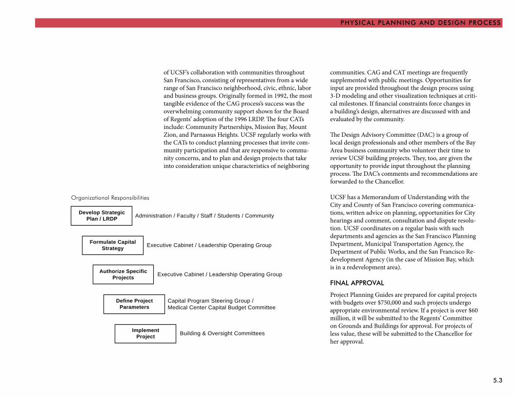
5.3
PHYSICAL PLANNING AND DESIGN PROCESS
of UCSF’s collaboration with communities throughout San Francisco, consisting of representatives from a wide range of San Francisco neighborhood, civic, ethnic, labor and business groups. Originally formed in 1992, the most tangible evidence of the CAG process’s success was the overwhelming community support shown for the Board of Regents’ adoption of the 1996 LRDP. The four CATs include: Community Partnerships, Mission Bay, Mount Zion, and Parnassus Heights. UCSF regularly works with the CATs to conduct planning processes that invite com-munity participation and that are responsive to commu-nity concerns, and to plan and design projects that take into consideration unique characteristics of neighboring
communities. CAG and CAT meetings are frequently supplemented with public meetings. Opportunities for input are provided throughout the design process using 3-D modeling and other visualization techniques at criti-cal milestones. If financial constraints force changes in a building’s design, alternatives are discussed with and evaluated by the community.
The Design Advisory Committee (DAC) is a group of local design professionals and other members of the Bay Area business community who volunteer their time to review UCSF building projects. They, too, are given the opportunity to provide input throughout the planning process. The DAC’s comments and recommendations are forwarded to the Chancellor.
UCSF has a Memorandum of Understanding with the City and County of San Francisco covering communica-tions, written advice on planning, opportunities for City hearings and comment, consultation and dispute resolu-tion. UCSF coordinates on a regular basis with such departments and agencies as the San Francisco Planning Department, Municipal Transportation Agency, the Department of Public Works, and the San Francisco Re-development Agency (in the case of Mission Bay, which is in a redevelopment area).
FINAL APPROVAL
Project Planning Guides are prepared for capital projects with budgets over $750,000 and such projects undergo appropriate environmental review. If a project is over $60 million, it will be submitted to the Regents’ Committee on Grounds and Buildings for approval. For projects of less value, these will be submitted to the Chancellor for her approval.
Organizational Responsibilities
Develop StrategicPlan / LRDP Administration / Faculty / Staff / Students / Community
Formulate CapitalStrategy Executive Cabinet / Leadership Operating Group
Authorize SpecificProjects Executive Cabinet / Leadership Operating Group
Define ProjectParameters
Capital Program Steering Group /Medical Center Capital Budget Committee
ImplementProject Building & Oversight Committees
5.4 PHYSICAL DESIGN FRAMEWORK
![SOFTWARE Open Access ImmunoGlobulin galaxy · PDF filedetermination and quantitation of immunoglobulin ... used like any physical computer [7] ... developed to generate the framework](https://img.pdfslide.tips/doc/110x75/5a9224627f8b9a8b5d8bdc0d/software-open-access-immunoglobulin-galaxy-and-quantitation-of-immunoglobulin.jpg)