Embed Size (px)
Citation preview
PTTPTT--102003102003SISTEM INFORMASI SISTEM INFORMASI
SUMBERDAYA LAHANSUMBERDAYA LAHAN
Kuliah ke 6Kuliah ke 6
INPUT DATA GEOGRAFIK
PENDAHULUAN
Input data geografik merupakan pekerjaan yang membutuhkan tenaga, waktu dan biaya yang cukup banyak (85 %) Minggu ini kita mempelajari sumber data
dan cara input data. Sumber: primer dan sekender Cara: capture dan transfer
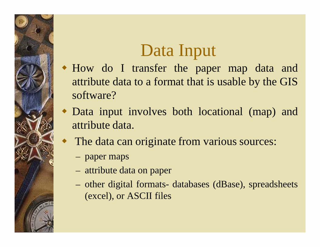
Data Input How do I transfer the paper map data and
attribute data to a format that is usable by the GISsoftware?
Data input involves both locational (map) andattribute data.
The data can originate from various sources:– paper maps– attribute data on paper– other digital formats- databases (dBase), spreadsheets
(excel), or ASCII files
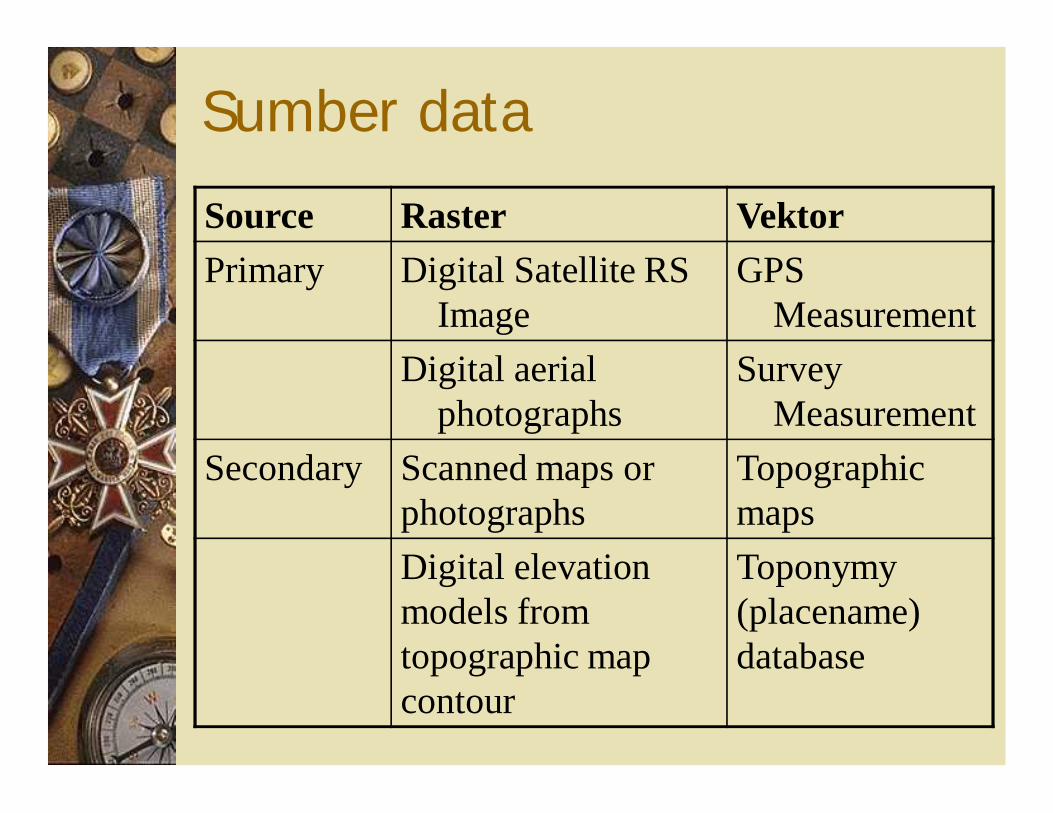
Sumber data
Source Raster VektorPrimary Digital Satellite RS
ImageGPS
MeasurementDigital aerial
photographsSurvey
MeasurementSecondary Scanned maps or
photographsTopographic maps
Digital elevation models from topographic map contour
Toponymy (placename) database
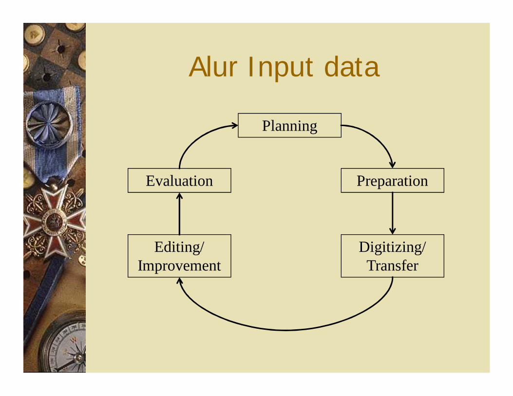
Alur Input data
Planning
Digitizing/ Transfer
Editing/ Improvement
Evaluation Preparation
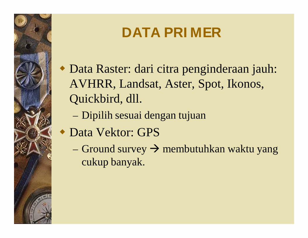
DATA PRIMER
Data Raster: dari citra penginderaan jauh: AVHRR, Landsat, Aster, Spot, Ikonos, Quickbird, dll.– Dipilih sesuai dengan tujuan
Data Vektor: GPS– Ground survey membutuhkan waktu yang
cukup banyak.
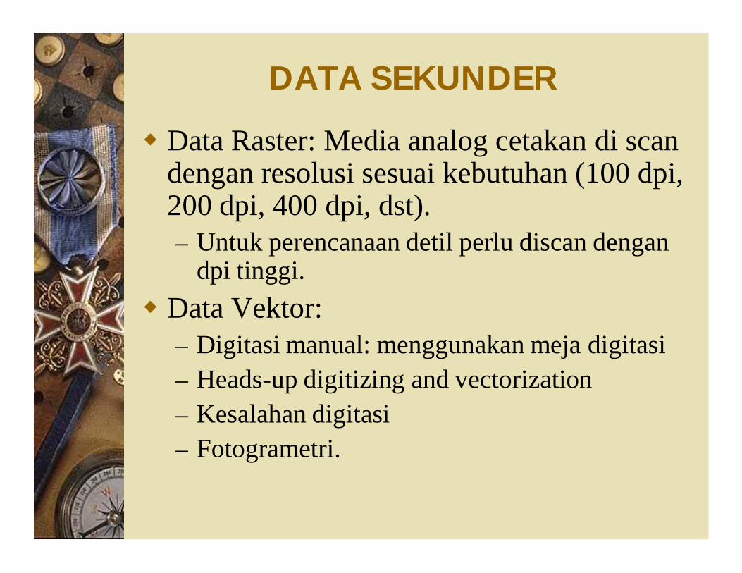
DATA SEKUNDER
Data Raster: Media analog cetakan di scan dengan resolusi sesuai kebutuhan (100 dpi, 200 dpi, 400 dpi, dst).– Untuk perencanaan detil perlu discan dengan
dpi tinggi. Data Vektor:
– Digitasi manual: menggunakan meja digitasi– Heads-up digitizing and vectorization– Kesalahan digitasi– Fotogrametri.
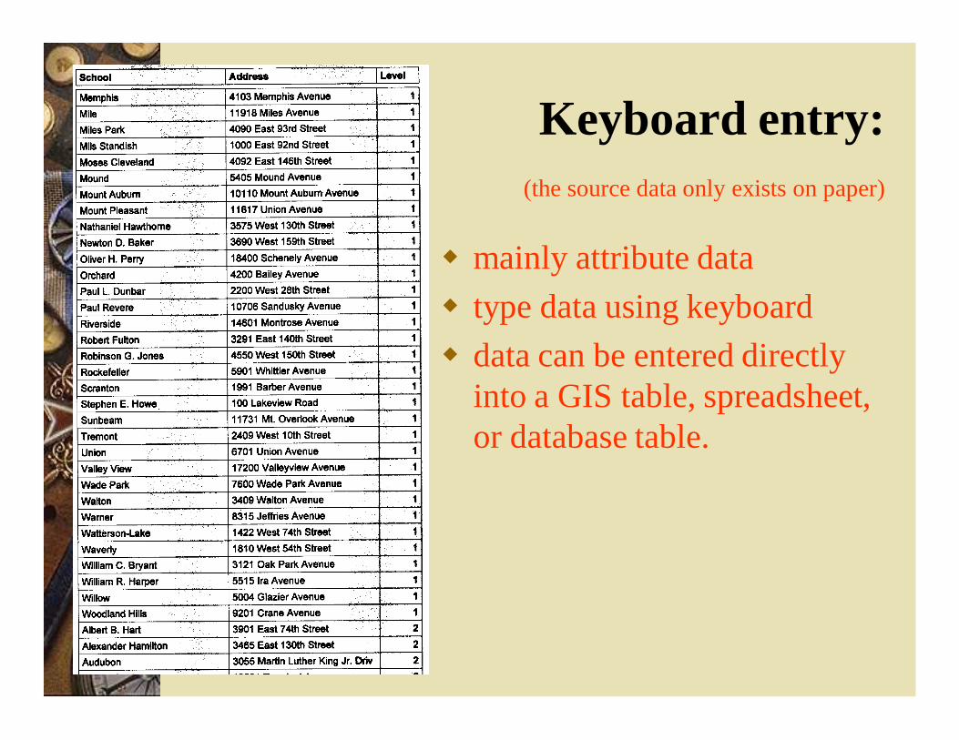
Keyboard entry:(the source data only exists on paper)
mainly attribute data type data using keyboard data can be entered directly
into a GIS table, spreadsheet, or database table.
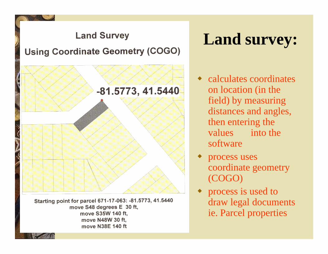
Land survey:
calculates coordinates on location (in the field) by measuring distances and angles, then entering the values into the software
process uses coordinate geometry (COGO)
process is used to draw legal documents ie. Parcel properties
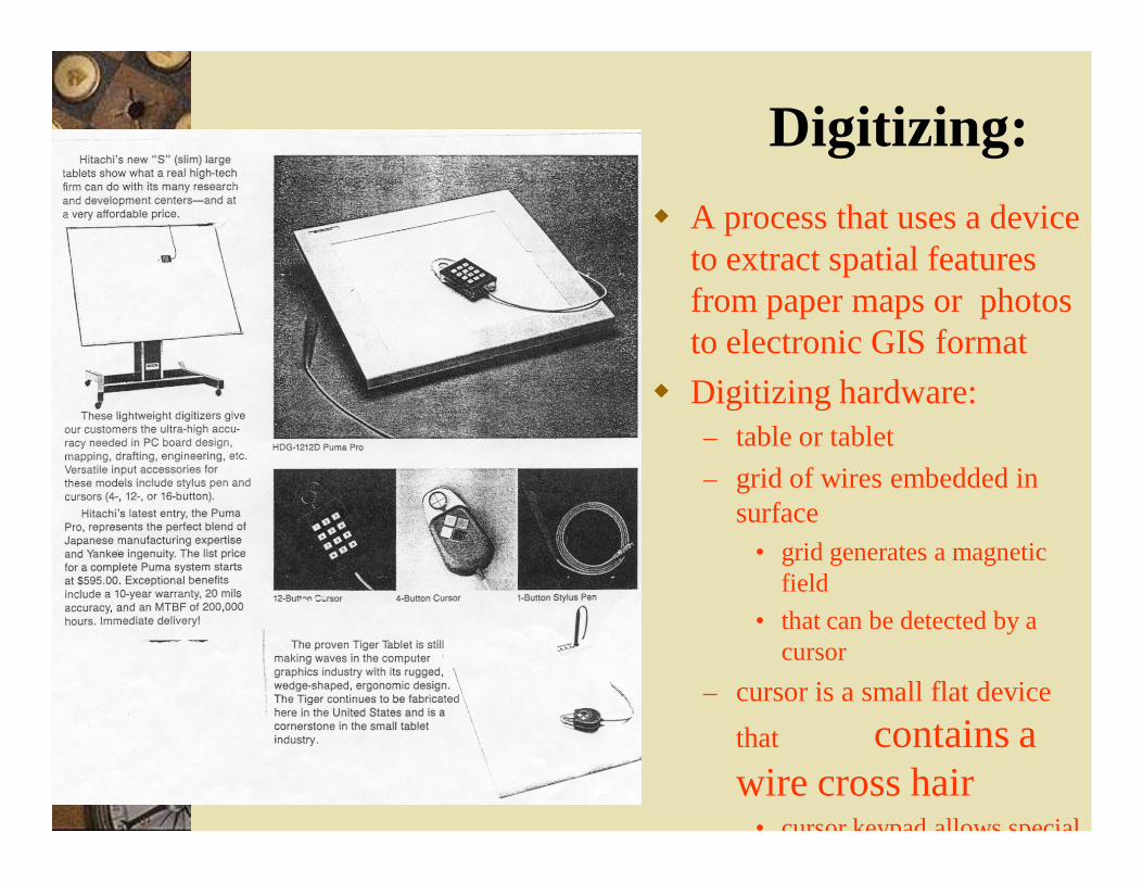
Digitizing: A process that uses a device
to extract spatial features from paper maps or photos to electronic GIS format
Digitizing hardware:– table or tablet– grid of wires embedded in
surface• grid generates a magnetic
field • that can be detected by a
cursor– cursor is a small flat device
that contains a wire cross hair
• cursor keypad allows special
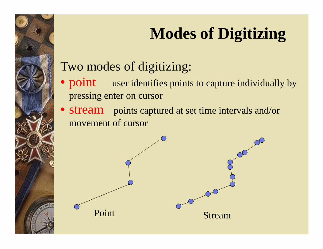
Modes of Digitizing
Two modes of digitizing:• point user identifies points to capture individually by
pressing enter on cursor• stream points captured at set time intervals and/or
movement of cursor
Point Stream
4/1/2013 12
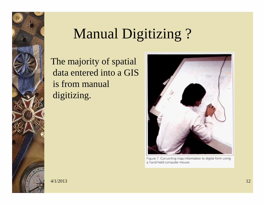
Manual Digitizing ?
The majority of spatial data entered into a GIS is from manual digitizing.
4/1/2013 13
Manual Digitizing
The digitizing tablet and table allow information to be traced from an existing map or graphic. Three different types of tables or tablets
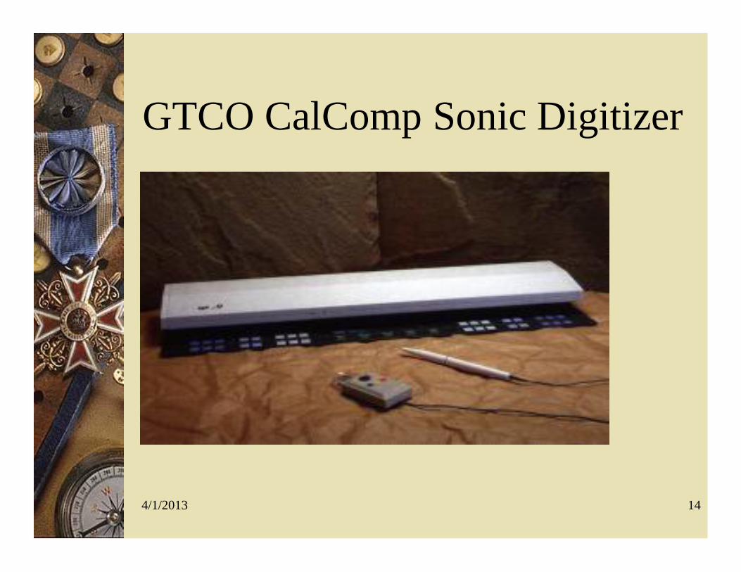
exist.– (1) Acoustic – the digitizing pen emits a high
frequency sound that is received by microphones at the corners of the work area, triangulation is used to calculate the x and y coordinate of the pen.
4/1/2013 14
GTCO CalComp Sonic Digitizer
4/1/2013 15
Types of Digitizers (Continued) (2) Resistivity uses two charged pads
separated by a thin air gap, x and y coordinates are determined when the pads make contact. (3) The most widely used in large scale
digitizers is the electronic digitizing tablet. Embedded below the surface of the table or the tablet is a grid of wires that measure the strength of the signal from the puck or the pen
4/1/2013 16
Qualities of a Digitizer
– Stability • The ability of the digitizer to maintain a
value as the puck remains in one place.– Repeatability
• Precision• Good digitizers accurate to 0.001 inch
4/1/2013 17
Qualities of a Digitizer #2
– Linearity • the ability to be within a specified distance of
the correct value• Good digitizers are able to have a linearity of
0.003 inch over 60 inches– Skew
• The ability to produce coordinates in a true rectangle.
4/1/2013 18
Digitizing Procedures The Map is fixed to the digitizing table. Three or more control points are digitized.
– Easily identified points (intersections of major streets, major peaks, points on coastline)
– These coordinates will be known or verified– The digitizing area is registered to the map area.
Digitizing the map can be done in two ways.– In point mode , the operator identifies the points
captured explicitly by pressing a button.– In stream mode the points are captured at regular
intervals (time or distance)
4/1/2013 19
Digitizing Procedures (cont)
Point mode is done subjectively by the operator (no two operators will digitize the same). Stream mode generates a large number of
points, many of which will be redundant. Most digitizing is done in point mode.
4/1/2013 20
Advantages of Digitizing
Low initial capital cost Flexible and adapts to different types of
data Easily mastered skill Digitizing devices are reliable Generally the quality of data is high
4/1/2013 21
Digitizing Vendors
Altek Calcomp Didger GTCO Kurta
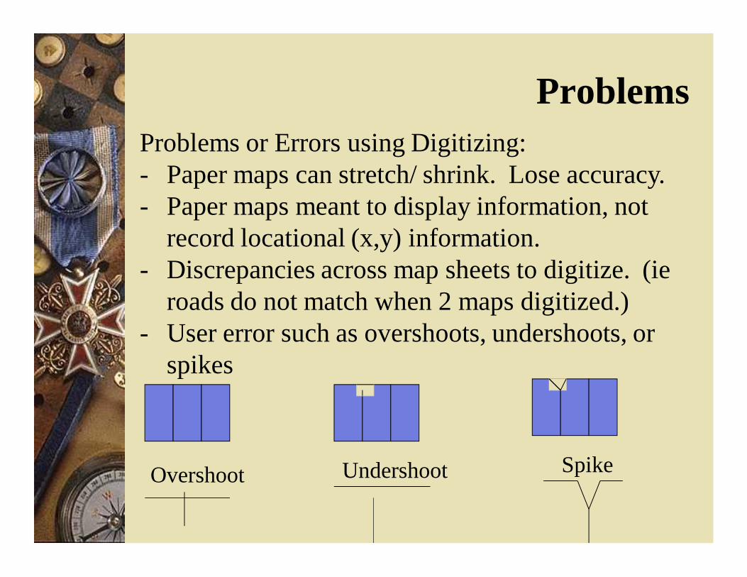
ProblemsProblems or Errors using Digitizing:- Paper maps can stretch/ shrink. Lose accuracy.- Paper maps meant to display information, not
record locational (x,y) information.- Discrepancies across map sheets to digitize. (ie
roads do not match when 2 maps digitized.)- User error such as overshoots, undershoots, or
spikes
Overshoot Undershoot Spike
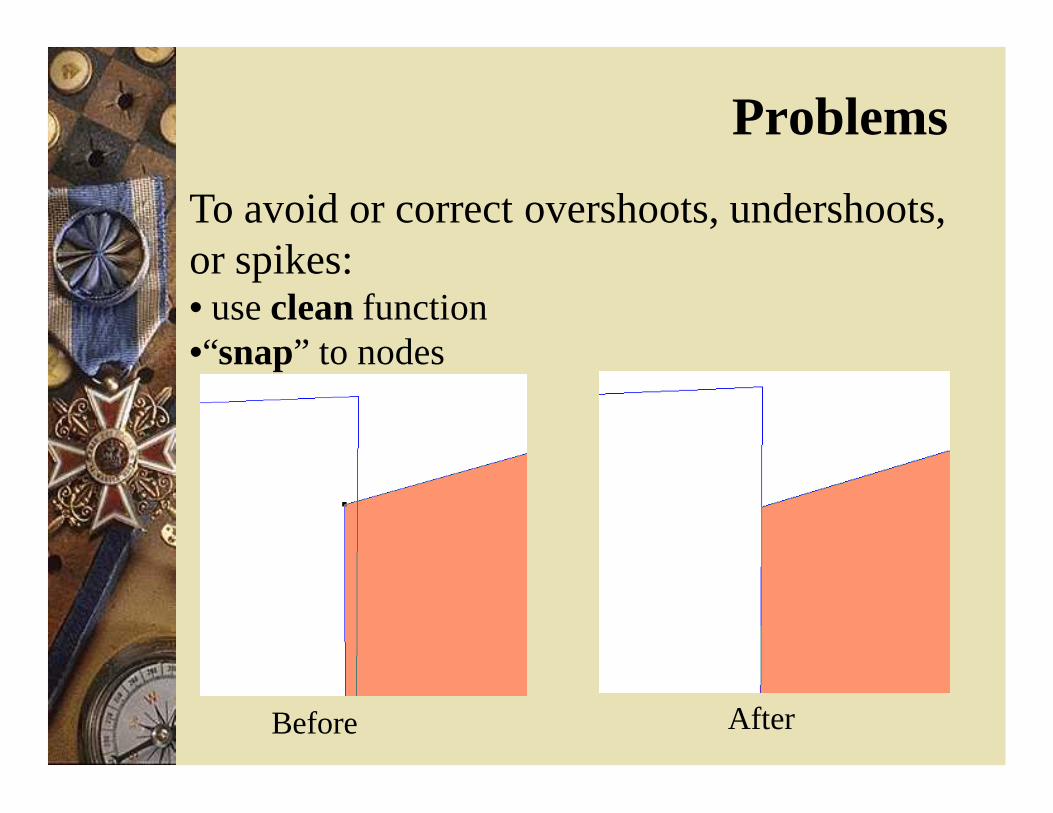
To avoid or correct overshoots, undershoots, or spikes:• use clean function•“snap” to nodes
Before After
Problems
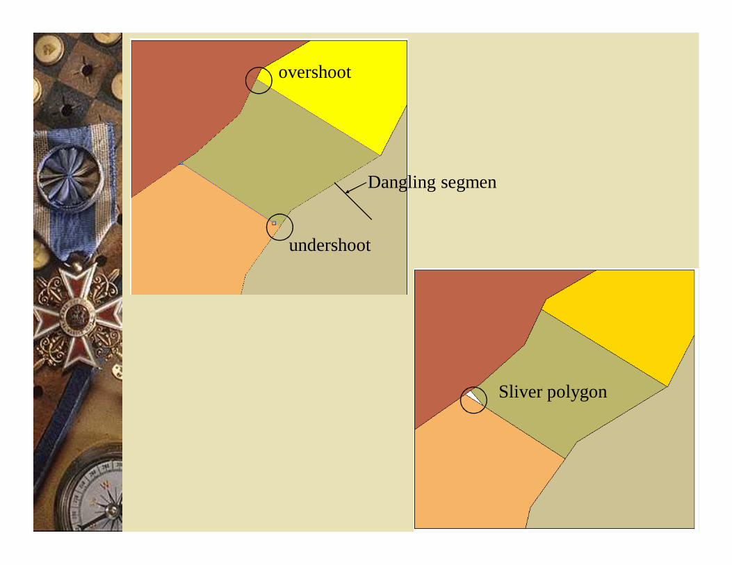
overshoot
undershoot
Dangling segmen
Sliver polygon
4/1/2013 25
Scanning Technology
Converts paper maps into digital format by capturing features as cells, or pixels. Cells are captured using a scanner head
made up of photosensitive cells. Advanced large format scanners have
heads with 8000 photosensitive cells Each sensor is able to record a pixel rated
between 0 (black) to 255 (white) and any graytones between.
4/1/2013 26
Color Scanning Technology
Color images use the same technique but the image is scanned for red, blue and green. Older scanners required the image being
scanned to pass the scanning head in three passes. Vectorization often requires color scanning
4/1/2013 27
Color Scanning Technology
Filters allow the head to pass the image once scanning all three colors at once The latest technology: full width, single
line, sensor array scanning uses a line of LED’s which capture the image LED scanners can create images using 16.8
million colors at speeds several times faster than previously obtained.
4/1/2013 28
Scanning Problems Higher resolutions aren’t always the answer to
better data; often the additional “noise” and resulting clean up of data can cause higher resolution to not be the best solution, a balance between detail and additional manual clean-up must be struck.
Paper maps are not “dimensionally stable” and a great deal of variation occurs as the maps age.
Documents must be clean (no smudges or extra marks or lines).
4/1/2013 29
Scanning Problems #2
Text may accidentally be scanned as line features in automatic feature recognition. Specialized symbols (for example marsh or
asphalt) may not be detected as such.
4/1/2013 30
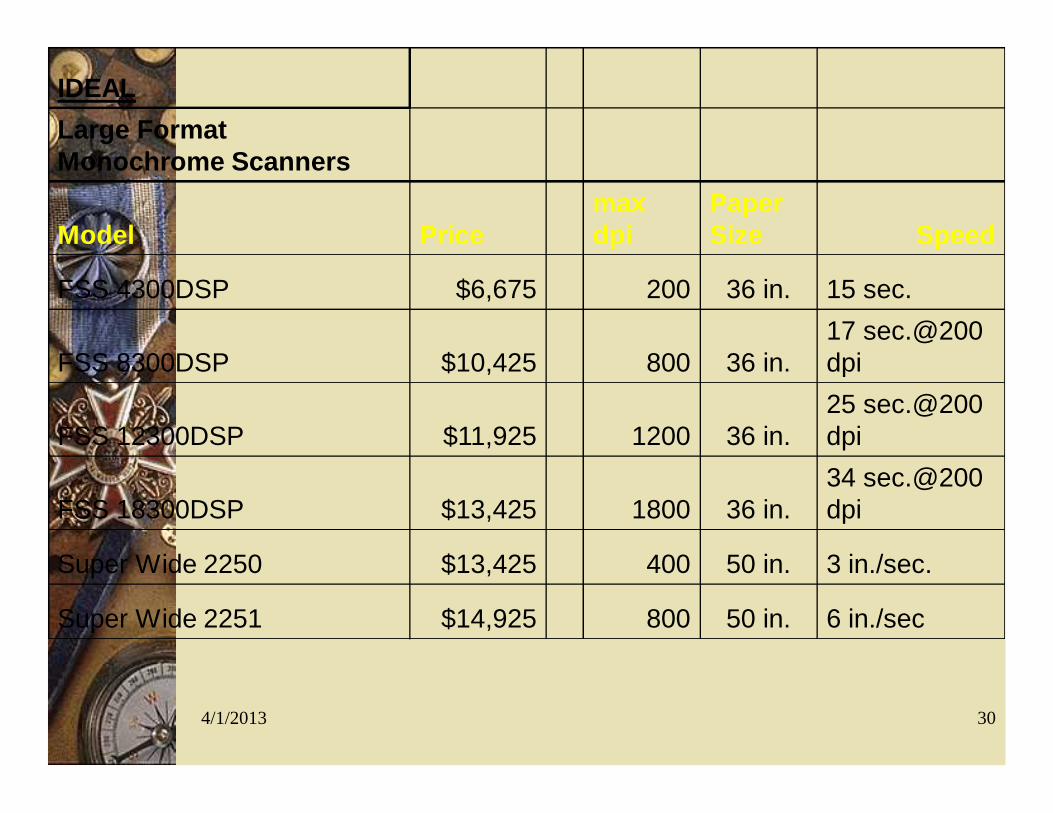
IDEALLarge Format Monochrome Scanners
Model Pricemax dpi
Paper Size Speed
FSS 4300DSP $6,675 200 36 in. 15 sec.
FSS 8300DSP $10,425 800 36 in.17 sec.@200 dpi
FSS 12300DSP $11,925 1200 36 in.25 sec.@200 dpi
FSS 18300DSP $13,425 1800 36 in.34 sec.@200 dpi
Super Wide 2250 $13,425 400 50 in. 3 in./sec.
Super Wide 2251 $14,925 800 50 in. 6 in./sec
4/1/2013 31
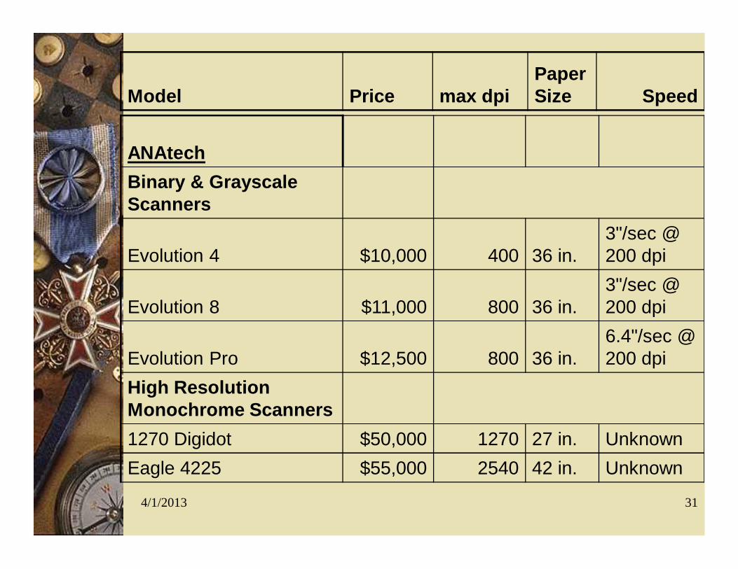
ANAtechBinary & Grayscale Scanners
Evolution 4 $10,000 400 36 in.3"/sec @ 200 dpi
Evolution 8 $11,000 800 36 in.3"/sec @ 200 dpi
Evolution Pro $12,500 800 36 in.6.4"/sec @ 200 dpi
High Resolution Monochrome Scanners1270 Digidot $50,000 1270 27 in. UnknownEagle 4225 $55,000 2540 42 in. Unknown
Model Price max dpiPaper Size Speed
4/1/2013 32
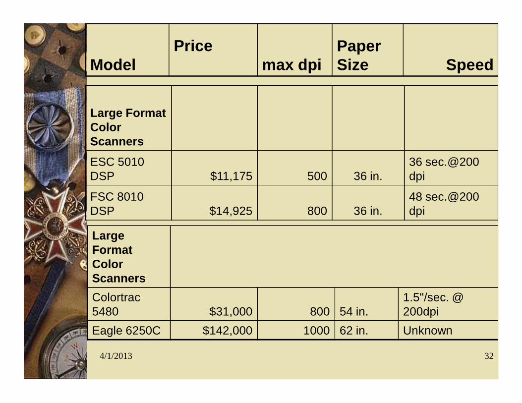
Large Format Color ScannersESC 5010 DSP $11,175 500 36 in.
36 sec.@200 dpi
FSC 8010 DSP $14,925 800 36 in.
48 sec.@200 dpi
Large Format Color ScannersColortrac 5480 $31,000 800 54 in.
1.5"/sec. @ 200dpi
Eagle 6250C $142,000 1000 62 in. Unknown
ModelPrice
max dpiPaper Size Speed
4/1/2013 33
Vendors for Scanners
Widecom Scanners– www.widecom.com/
Anatech Scanners– www.anatech.com/
Vidar Systems Corporation– www.delinfotek.com/
Abakos Digital Images– www.abakos.com.au/
Contex Scanning Technologies– www.caddcentreindia.com/

4/1/2013 34
Digitizer or Scanner Scanners
– Speed and ease– Raster data without
intelligence; manual or automatic vectorisation possible.
– Usually produces large files that need compression
– Hardware is expensive
Digitizers– Labor intensive– Requires skilled operator– Vector (intelligent) data– Labor intensive– Hardware less expensive
4/1/2013 35
Scanning & Digitizing Input Errors
Incompleteness of the spatial data; missing points, line segments, and polygons. Location placement errors of spatial data;
careless digitizing or poor quality of the original source. Distortion of spatial data; base maps that
aren’t scale correct over the entire image or from material stretch in paper maps.
4/1/2013 36
Scanning & Digitizing Input Errors #2
Incorrect linkage between spatial and attribute data; misplaced labels or unique identifiers being assigned during manual key entry or during the initial setup.
Attribute data is wrong or incomplete; missing data records or data records from different time periods.
Redundant information, including vertices, text, nodes, and arcs.
Incorrect label information and placement.
4/1/2013 37
Common Spatial Errors
Slivers or gaps in the line work. Dead ends, dangling arcs, overshoots and
undershoots. Bow ties or weird polygons caused by
inappropriate closings of connecting features.
4/1/2013 38
Data Verification
Visual review; usually done by reviewing a check plot (hard copy).
Cleanup of lines and junctions; this process is usually done by software and then through manual editing.
Check source maps, if additional copies of the same map are available compare them to see if stretching of the map has occurred.
Check output drawing to see if text or symbols were read as features if software is used to convert the drawings.
DATA TRANSFER
Dari format data lain
Data Yang DimasukkanDATA ANALOG
– Peta – Data Tabulasi
DATA DIGITAL– Peta– Tabel
• Disesuaikan dengan tujuan dan data yang tersedia
• Menentukan keefisienan dan keefektifan sistem pengelolaan data dalam SIG
• Berpengaruh terhadap besarnya data yang diperlukan
PERSIAPAN PEMASUKAN DATATERGANTUNG DARI DATA YANG TERSEDIA
Data tabular: diketik ke dalam “spread sheet” Foto Udara:
– Interpretasi– Koreksi geografik– Digitasi
Data dijital lain– Konversi ke format yang dituju
Data lapangan:– Tabulasi– Klasifikasi
PERSIAPAN PEMASUKAN DATA
a. Kualitas data sering dipengaruhi oleh lembaga penghasil dataLokal:
– hanya untuk kepentingan sendiri sulit diintegrasi
Regional/Nasional: – untuk kepentingan banyak pemakai mudah diintegrasi
b. Sumber data• lapangan
• interpretasi citra (foto udara/satelit)
Pertimbangan lain:
PERSIAPAN PEMASUKAN DATA
c. Waktu pengambilan
tergantung macam data:
data vegetasi/penggunaan lahan sebaiknya yang terbaru
tanah: bisa lama asal klasifikasinya sama
untuk monitoring: periode waktu tertentu tergantung tujuan, harian, mingguan, bulanan, tahunan, dll
Pertimbangan lain:
d. Lain-lain
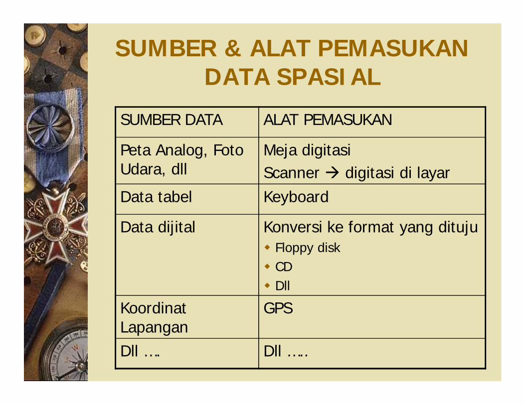
SUMBER & ALAT PEMASUKAN DATA SPASIAL
SUMBER DATA ALAT PEMASUKAN
Peta Analog, Foto Udara, dll
Meja digitasiScanner digitasi di layar
Data tabel Keyboard
Data dijital Konversi ke format yang dituju Floppy disk CD Dll
Koordinat Lapangan
GPS
Dll …. Dll …..
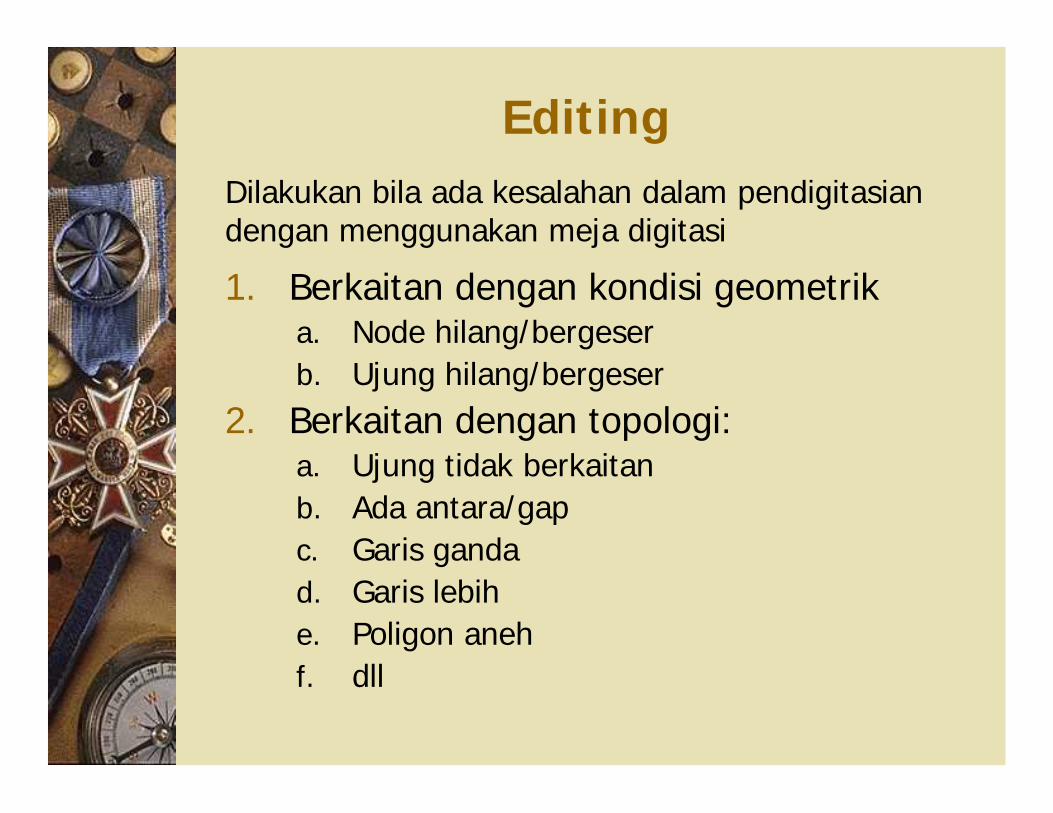
Editing
1. Berkaitan dengan kondisi geometrika. Node hilang/bergeserb. Ujung hilang/bergeser
2. Berkaitan dengan topologi:a. Ujung tidak berkaitanb. Ada antara/gapc. Garis gandad. Garis lebihe. Poligon anehf. dll
Dilakukan bila ada kesalahan dalam pendigitasian dengan menggunakan meja digitasi
Pemasukan dengan Scanner
Produknya berupa data raster Perlu perampingan bentuk garis agar
koordinatnya dapat dikenali dengan baik Kadang perlu vektorisasi Untuk data yang kompleks (misal peta
topografi), seringkali harus dilakukan penggambaran kembali
Ada dua macam: – flat-bed scanner – drum-scanner
Pemasukan dengan Digitasi Layar Komputer
Peta disiam (dengan menggunakan scanner)
Ditampilkan pada layar monitor Didigitasi langsung di layar (+ editing jika
terjadi kesalahan) Registrasi untuk mendapatkan koordinat Bermanfaat untuk menambah informasi
yang tidak terdapat pada peta asli, misal pola drainase yang wilayah berbukit/bergunung. Dengan melakukan overlay dengan foto udara atau citra satelit pola drainase dapat ditambahkan.
Pemasukan data dengan GPS
Untuk koreksi geometri Menentukan koordinat obyek di lapangan
secara tepat, misal lokasi pemboran, minipit, profil tanah dsb.
Bisa berfungsi sebagai digitasi obyek di lapangan
Kelemahan: membutuhkan ruang terbuka, pada ruang yang tertutup (dibawah pohon) menghasilkan deviasi yang besar
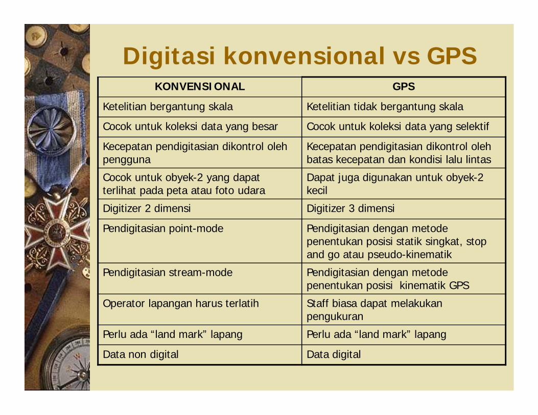
Digitasi konvensional vs GPSKONVENSIONAL GPS
Ketelitian bergantung skala Ketelitian tidak bergantung skala
Cocok untuk koleksi data yang besar Cocok untuk koleksi data yang selektif
Kecepatan pendigitasian dikontrol oleh pengguna
Kecepatan pendigitasian dikontrol oleh batas kecepatan dan kondisi lalu lintas
Cocok untuk obyek-2 yang dapat terlihat pada peta atau foto udara
Dapat juga digunakan untuk obyek-2 kecil
Digitizer 2 dimensi Digitizer 3 dimensi
Pendigitasian point-mode Pendigitasian dengan metode penentukan posisi statik singkat, stop and go atau pseudo-kinematik
Pendigitasian stream-mode Pendigitasian dengan metode penentukan posisi kinematik GPS
Operator lapangan harus terlatih Staff biasa dapat melakukan pengukuran
Perlu ada “land mark” lapang Perlu ada “land mark” lapang
Data non digital Data digital
PEMANFAAT DATA DIGITAL Dinegera maju data digital dan
pendukungnya sudah banyak tersedia Di Indonesia sedang dirintis Lembaga yang mengurusi:
BAKOSURTANAL (Badan Koordinasi Survei dan Pemetaan Nasional) Format data spasial yang ada: ArcInfo, ArcView, Erdas, Idrisi, ILWIS,
Auto-cad, MapInfo, kadang juga dalam bentuk BMP, TIFF, JPG.
DATA YANG TERSEDIA
Data kartografik:– Bakosurtanal
Data sumberdaya alam– Tanah: Puslitbangtanak, Bogor– Penggunaan Lahan: BPN– Geologi: Puslitbang Geologi Bandung
Data elevasi digital Data kartografik berkaitan dengan sensus
– BPS