Embed Size (px)
Citation preview

RADARSAT Polar Science Gateway
Yves Crevier, Paul Briand
Government-Related Initiatives Program
Canadian Space Agency

Presentation Outline
• Context and concept of the RADARSAT Polar Science Gateway (RSAT PSG)
• Canadian Earth Observation Assets for IPY– Radarsat 1-2, etc.
• RADARSAT Polar Science Gateway Components
• Seek for collaboration opportunities

IPY 2007-2008• International IPY
Received the full IPY endorsement from the International Program Office –March 06
Linked to the "Global Inter-agency International Polar Snapshot Year" -GIIPSY proposal #91
• Canada Federal IPY programParticipation: 239 Canadian expressions of interest. Govt of Canada
funding $150 million. Proposal submitted to the Federal IPY Program Office in March 06Nomination of CSA staffs – Federal IPY Working Groups
• CSA proposal - RADARSAT Polar Science GatewayWhat: observation source for science and northernersHow: use partnershipsScope: Canadian & international - both poles; partners/users from anywhere
RADARSAT Polar Science Gateway
• Objectives • to create and disseminate a circumpolar Arctic data treasury of
satellite-based radar data and derived information products in support of science for climate change research and local needs of northern peoples and communities.
• Highlights• Making use of Radarsat archives and missions – RSAT-1,-2,-C
• Serve urgent Canadian & international goals
• In support of science and northern communities
• With partners and levered resources
• A lasting legacy

Global Inter-Agency IPY Polar Snapshot Year (GIIPSY)
• Develop an international science plan for coordinated spaceborne observation of the polar regions;
• Obtaining critical benchmark of processes in the Arctic and Antarctic during the IPY and to set the stage for acquiring future benchmarks beyond IPY;
• Also obtaining diverse but integrated set of observations;• Make the resulting data and derived products available to
the international science community;• Lead by ESA and Ohio State U;• CSA, DLR, ISRO, JAXA, NASA, IGOS-P Cryosphere…
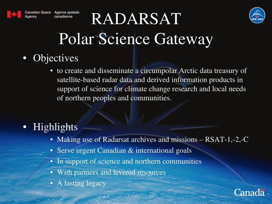
500 km
250 km
49
20
500 km
250 km
V
o
o
Extended Beams(High Incidence)
Extended Beams(Low Incidence)
Wide-SwathBeams
Fine-ResolutionBeams (50 km Swath)
ScanSAR
Subsatellite Track
All beam modesavailable in Left-looking Mode
StandardBeams
Standard ResolutionQuad Polarization(reduced swath width)
Multi-Look Fine Resolution
Fine ResolutionQuad Polarization(reduced swath width)
Ultra-fineBeams
AI-8760-91CR2-CD
RADARSAT-2
RADARSAT-1

RADARSAT Polar Science Gateway
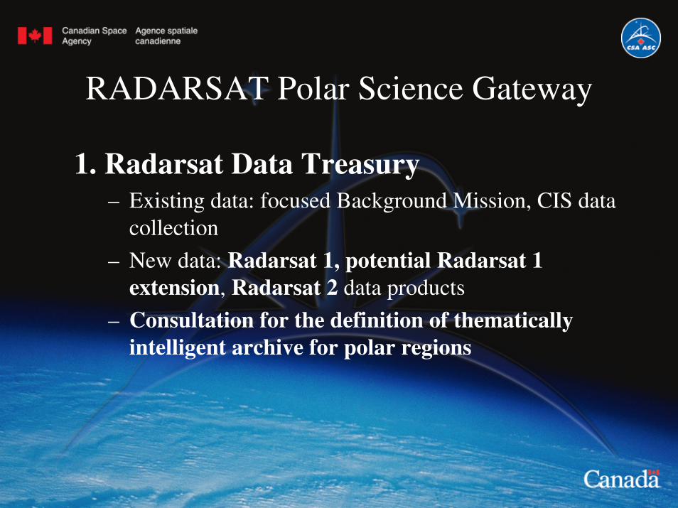
1. Radarsat Data Treasury
2. Portal
3. Diffusion, outreach & capacity development
RADARSAT Polar Science Gateway
1. Radarsat Data Treasury– Existing data: focused Background Mission, CIS data
collection
– New data: Radarsat 1, potential Radarsat 1 extension, Radarsat 2 data products
– Consultation for the definition of thematically intelligent archive for polar regions
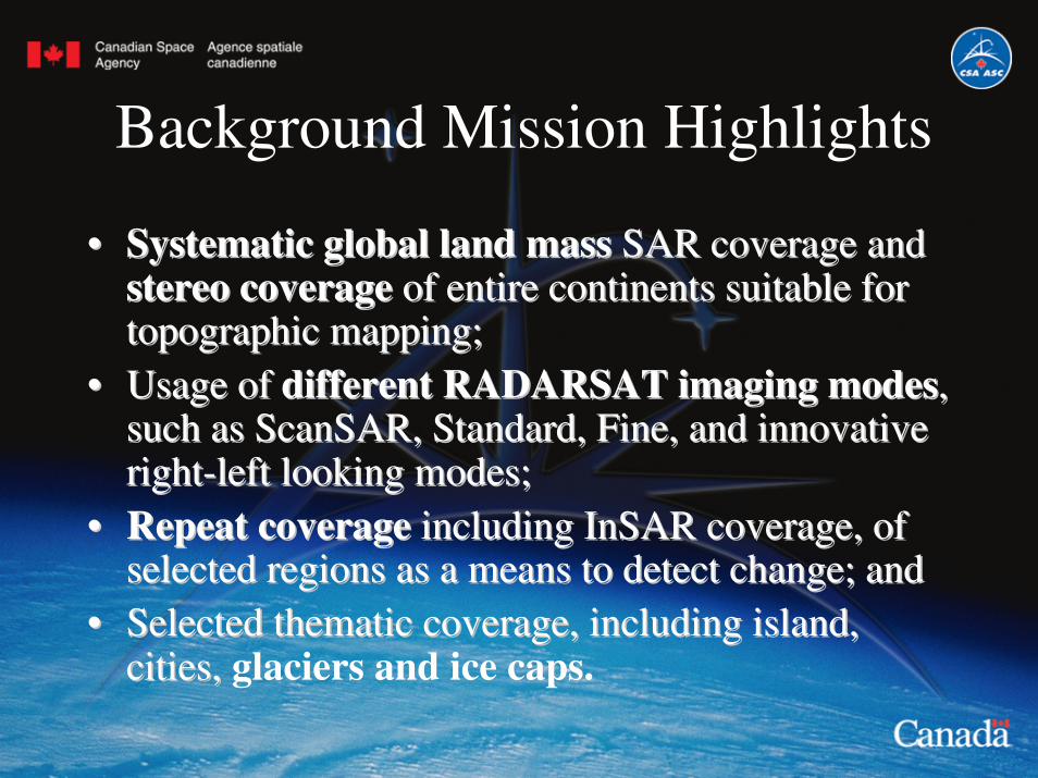
Background Mission Highlights
•• Systematic global land massSystematic global land mass SAR coverage and SAR coverage and stereo coveragestereo coverage of entire continents suitable for of entire continents suitable for topographic mapping;topographic mapping;
•• Usage of Usage of different RADARSAT imaging modesdifferent RADARSAT imaging modes, , such as such as ScanSARScanSAR, Standard, Fine, and innovative , Standard, Fine, and innovative rightright--left looking modes;left looking modes;
•• Repeat coverageRepeat coverage including including InSARInSAR coverage, of coverage, of selected regions as a means to detect change; andselected regions as a means to detect change; and
•• Selected thematic coverage, including island, Selected thematic coverage, including island, cities, cities, glaciers and ice caps.
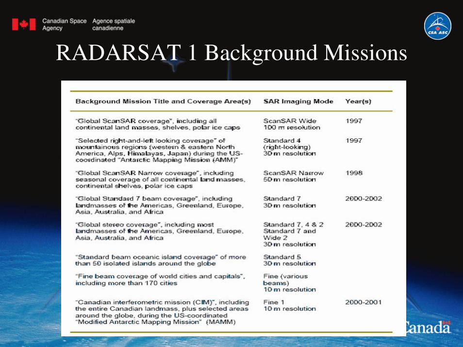
RADARSAT 1 Background Missions

2003 Arctic Basin Coverage
Arctic Basin area = 10ºC July IsothermCoverage completion: ~85.3%Start date: October 3, 2003End date: October 31, 2003
Arctic Basin area = 10ºC July Isotherm
Coverage completion: ~90.8%Start date: July 30, 2003End date: August 6, 2003
Summer Fall

2004 Arctic Basin Coverage
Arctic Basin area = 10ºC July IsothermCoverage completion: ~90.6%Start date: January 9, 2004End date: February 6, 2004
Winter Spring
Arctic Basin area = 10ºC July Isotherm
Coverage completion: ~77.8%Start date: April 19, 2004End date: April 25, 2004

2004 Arctic Basin Coverage
Arctic Basin area = 10ºC July IsothermCoverage completion: ~98.9%Start date: July 23, 2004End date: August 6, 2004
Summer Fall
Arctic Basin area = 10ºC July Isotherm
Coverage completion: ~85.0%Start date: October 4, 2004End date: October 11, 2004

2005 Arctic Basin Coverage
Arctic Basin area = 10ºC July IsothermCoverage completion: ~81.4%Start date: January 8, 2005End date: February 15, 2005
Winter Spring
Arctic Basin area = 10ºC July Isotherm
Coverage completion: ~76.5%Start date: April 14, 2005End date: May 3, 2005
©C
anad
ian
Spa
c eA
gen c
y/ A
genc
e sp
a tia
le c
anad
ienn
e, 1
997
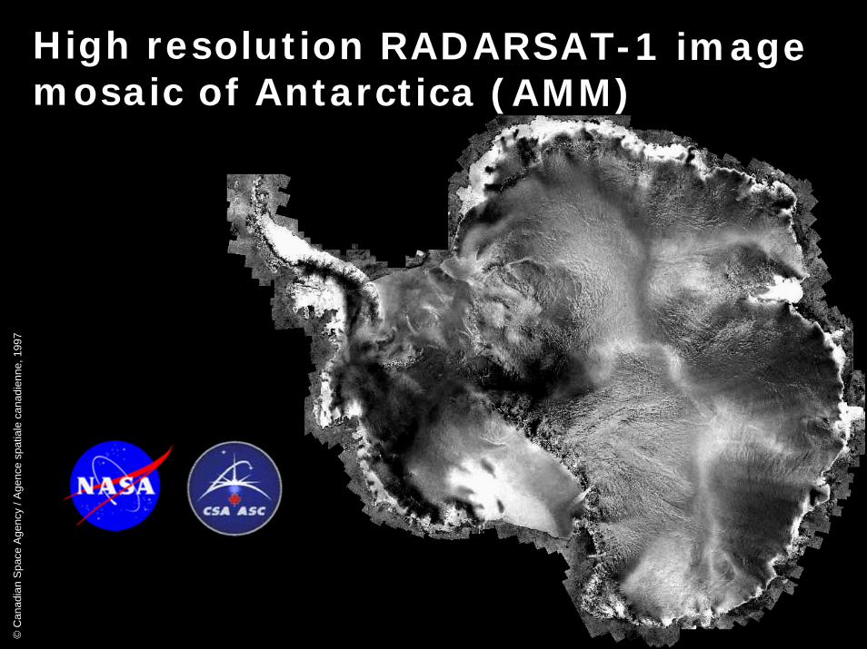
High resolution RADARSAT-1 image mosaic of Antarctica (AMM)

New Potential Mapping Initiatives
• 3rd Antarctic Mapping Mission
• Greenland Mapping Mission (InSAR)
• Polar Snapshots – Sea ice (CIS)
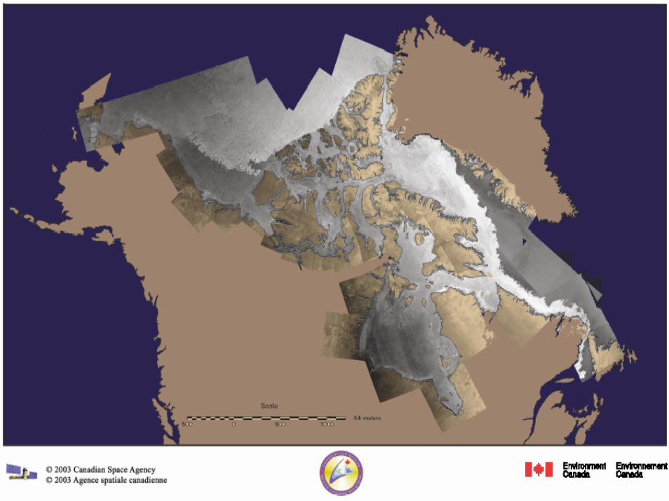
• Arctic Ice Mapping Mission – (AIMM) – Ellesmere,Alex Heiberg, Devon, Baffin, Bylot
• Canadian Arctic Land masses

RADARSAT Data Treasury• Challenges
– Data policy• Distribution framework for Radarsat-1: Commercial
• Radarsat-2 owned and operated by MDA – use of Canadian Government Data Allocation
• Restricted to science use – NO operations supported
– Identification and processing "science-relevant" datasets – through consultation
– Non-intuitive nature of SAR data – definition of data and information products for broad distribution

RADARSAT Polar Science Gateway
2. Portal
– interfaces designed for scientists, information product users, and northern community users
– welcomes traditional knowledge and queries from it
– links / integration with other portals• CCIN, Arctic Spatial Data Infrastructure, PolarVIEW,
GIIPSY, etc…

RADARSAT Polar Science Gateway
3. Diffusion, outreach & capacity development
– Work with Northerners on northern issues– Adapted training and capacity building – Needs to develop a strategy to promote optimal design &
use for Canadians– Consult the ultimate surrogates and intermediate
stakeholders (scientists) to use and develop the treasury– Anik F2 potential for telecommunications bandwidth– 3 northern community access terminals

Financing
• from IPY Federal Program budget• Radarsat-2 Canadian Data Allocation
• by partners’ funding, including some from Canadian IPY and other national IPY
• CSA staff time and O&M to manage it
• continuation after IPY
Summary: Outputs & Outcomes
• RADARSAT data & products are put into use
• New partnerships with science and clients / users. A known strategy and hub for northerners and northern applications
• World-contributing new northern EO presence and strengthened Antarctic EO presence
• Contributing to Canadian goals for northern sustainability, resources management, sovereignty, and science
• Canadian satellite EO coordinated with global goals and data demand and supply.

Action Plan
• Consultation to guide strategic development of RSAT Polar Science Gateway and optimal use of its resources
• Consultation with end-users for a data plan • Coordination among the space agencies within the GIIPSY
framework • Coordination with other Information Network managers
and linkages • Seek additional partners (via IPY & other)• Liaison with Canada IPY
(steering committees, possible further proposals)• Coordination & agreement

Confirmed Collaborations