Embed Size (px)
Citation preview
Report of the
Croatian Committee of Geodesy and Geophysics
on activities carried out between 2011 and 2014
Submitted to the General Assembly of the
International Union of Geodesy and Geophysics,
Prague, Czech Republic, 2015
Zagreb, Split, 2015
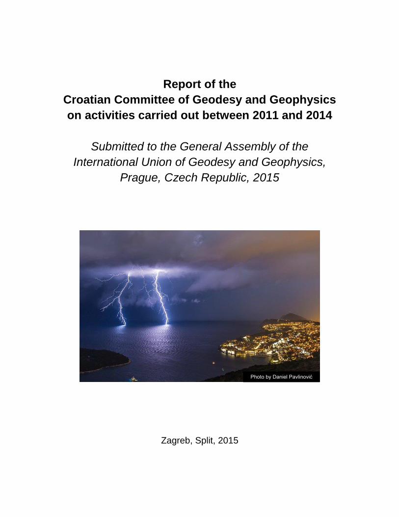
Photo by Daniel Pavlinović
2
Contents
Introduction ..…………………………………………..……………. 3
Geodesy in Croatia, 2011–2014 ………………………………….. 4
Geomagnetism and aeronomy in Croatia, 2011–2014 …………10
Hydrology in Croatia, 2011–2014 …………………………………14
Meteorology in Croatia, 2011–2014 ………………………………21
Physical oceanography in Croatia, 2011–2014 …………………28
Seismology in Croatia, 2011–2014 ……………………………….37
3
Introduction
Croatia was admitted to the International Union of Geodesy and Geophysics (IUGG) soon after gaining independence: its membership status had been provisionally granted by the IUGG Executive Committee already in 1992 and the status was ratified by the IUGG Council at the meeting held in Boulder in 1995. From the beginning, the Croatian Academy of Sciences and Arts was the adhering organization, which supervised the election of members of the Croatian Committee of Geodesy and Geophysics. After being admitted to the IUGG, Croatian geodesists and geophysicists took part in the activities of IUGG associations and in the general assemblies. Moreover, they prepared reports on their work, covering three intervals: 1991–1994 (Geofizika, 11, 1994), 1995–1998 (Geodetski list, 53, 1999), and 1999–2002 (Geofizika, 18/19, 2001/2002). After an eight-year break, the practice of reporting to the IUGG is reestablished with this report. In the following pages, the work carried out between the years 2011 and 2014 by Croatian scientists, active in geodesy and in five geophysical disciplines (geomagnetism and aeronomy, hydrology, meteorology, physical oceanography, and seismology), is documented. The report shows that Croatian geodesists and geophysicists represent a vibrant part of the scientific community: most often their findings are relevant for Croatia and sometimes their results and methodological improvements turn out to be useful to colleagues working in other countries. The four-year output is impressive, having in mind the recent decline in national funding of research activities. It appears that the problem was partially offset by an improved access to international research projects. Although the international projects could complement but could not replace the national projects, it is to be hoped that the international collaboration of Croatian scientists will expand in the future and that the IUGG-related activities will contribute to the expansion.
Mirko Orlić, President,
Croatian Committee of Geodesy and Geophysics
4
Geodesy in Croatia, 2011–2014
Report submitted to the International Association of Geodesy of the International Union of
Geodesy and Geophysics
Tea Duplančić Leder Faculty of Civil Engineering, Architecture and Geodesy, University of Split, Croatia
This report presents a brief overview of research activities in the field of geodesy in Croatia in the period from 2011 to the end of 2014. The geodesy research has been carried out mainly at the Geodetic Faculty (GEOF), University of Zagreb, and to a smaller extent at the Faculty of Civil Engineering, Architecture and Geodesy (FGAG), University of Split, and at the State Geodetic Administration (SDA). Research activities resulted in about dozen international peer-review (WoS) publications and a dozen of editor's books and book chapters.
The following research funded by the Ministry of Science, Education and Sports of the
Republic of Croatia was performed by the Geodetic Faculty, University of Zagreb: 1. Height kinematics and dynamics of the Croatian continental crust; 2. Cartography of the Adriatic, 3. Geodetic management and monitoring of large objects; 4. Geopotential and geodynamics of the Adriatic (Geo++Adria); 5. Geoinformatics and geomatic engineering in the environmental protection; 6. Modern ultrasonic survey methods in the sustainable development of karst areas; 7. Scientific metrology laboratory for survey instruments development. The projects were mosty continuation of previous scientific investigations in the field of geodesy, geodetic application in other disciplines, and interdisciplinary research topic (described in the previous report).
International scientific projects at the Geodetic Faculty, University of Zagreb, were:
1. Joint Croatian-Hungarian geomagnetic repeat station survey and joint geomagetic field model;
2. Toolbox implementation for removal of anti-personnel mines sub-munitions and UXO (TIRAMISU);
3. COST Acion TU0801: Semantic enrichment of 3D city models for sustainable urban development;
4. The impact of GNSS and the NSDI on spatial data use and their synergistic impact on management processes in Croatia and the region – SINERGIJA;
5. Geodetic-geological studies of loess edge plateau erosion in Croatian Danube; 6. Geodetic and geodynamic investigation of the recent movement of the lithosphere in
sediments of Dinarides area.
5
Scientific research results have been mainly published in the ISI Web of Knowledge journals (Survey Review, Technical Gazette, Annals of Geophysics) and domestic journals (Geodetski list, Kartografija i geoinformacije, Ekscentar). Also, research results have been presenteed at numerous international and domestic scientific conferences covering geodesy and appliedd geodesy measurement topics.
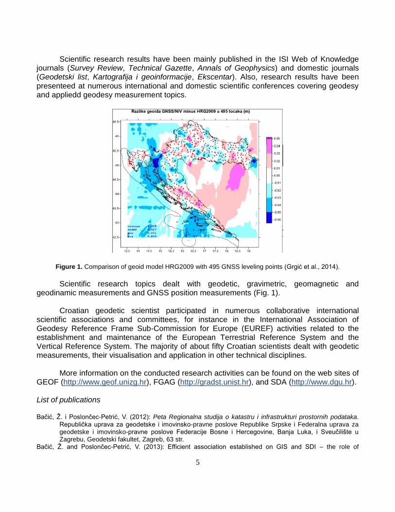
Figure 1. Comparison of geoid model HRG2009 with 495 GNSS leveling points (Grgić et al., 2014).
Scientific research topics dealt with geodetic, gravimetric, geomagnetic and
geodinamic measurements and GNSS position measurements (Fig. 1). Croatian geodetic scientist participated in numerous collaborative international
scientific associations and committees, for instance in the International Association of Geodesy Reference Frame Sub-Commission for Europe (EUREF) activities related to the establishment and maintenance of the European Terrestrial Reference System and the Vertical Reference System. The majority of about fifty Croatian scientists dealt with geodetic measurements, their visualisation and application in other technical disciplines.
More information on the conducted research activities can be found on the web sites of
GEOF (http://www.geof.unizg.hr), FGAG (http://gradst.unist.hr), and SDA (http://www.dgu.hr). List of publications Bačić, Ž. i Poslončec-Petrić, V. (2012): Peta Regionalna studija o katastru i infrastrukturi prostornih podataka.
Republička uprava za geodetske i imovinsko-pravne poslove Republike Srpske i Federalna uprava za geodetske i imovinsko-pravne poslove Federacije Bosne i Hercegovine, Banja Luka, i Sveučilište u Zagrebu, Geodetski fakultet, Zagreb, 63 str.
Bačić, Ž. and Poslončec-Petrić, V. (2013): Efficient association established on GIS and SDI – the role of
6
education and communication with subjects and users, Geonauka, 1/2, 17-23. Barišić, A., Crnković, A. and Hećimović, Ž. (2011): Satellite orbits optimized for satellite supported services on
the territory of Croatia, Tehnički vjesnik, 18, 179-186. Beban-Brkić, J., Šimić, M. and Volenec, V. (2011): Diagonal triangle of a non-tangential quadrilateral in the
isotropic plane, Mathematical Communications, 16, 157-168. Bennett, R.A., Serpelloni, E., Hreinsdottir, S., Brandon, M.T., Buble, G., Basic, T., Casale, G., Cavaliere, A.,
Anzidei, M., Marjanovic, M., Minelli, G., Molli, G. and Montanari, A. (2012): Synconvergent extension observed using the RETREAT GPS network, Journal of Geophysical Research – Solid Earth, 117, 1-23.
Brajković, R., Cetl, V. i Blagonić, B. (2010): Geomarketing Istarske županije, Istarski geodet, 6, 27-34. Brkić, M., Špoljarić, D. i Markovinović, D. (2011): Geomagnetska i GNSS izmjera vrha otočića Jabuka, Geodetski
list, 65 (88), 195-204. Brkić, M., Šugar, D., Pavasović, M., Vujić, E. and Jungwirth, E. (2012): Croatian geomagnetic field maps for
2008.5 epoch, Annals of Geophysics (A), 55 (6), 1061-1069. Brkić, M., Varga, M. i Poslončec-Petrić, V. (2013): Geomagnetsko polje za epohu 2009.5, U: M. Brkić, ur.:
Osnovna geomagnetska mreža Republike Hrvatske 2004–2012, s kartama geomagnetskog polja za epohu 2009.5. Državna geodetska uprava, Zagreb, 33-38.
Cetl, V., Barišić, B. i Šarušić, I. (2010): Prevođenje katastarskih podataka u novi državni koordinatni sustav HTRS96/TM, Šumarski list, 11/12, 593-602.
Cetl, V. (2011): INSPIRE in Kroatien, In: M. Schilcher, Ed.: INSPIRE-GMES-Informationsbroschüre, Siebte, vollständig überarbeitete und erweiterte Auflage. Runder Tisch Geoinformationssysteme e.V, Muenchen, 47-48.
Cetl, V., Roić, M. and Mastelić Ivić, S. (2012): Towards a real property cadastre in Croatia, Survey Review – Directorate of Overseas Surveys, 44, 17-22.
Cetl, V., Tóth, K., Abramić, A. and Smits, P. (2013): Report on the Status of INSPIRE in the Balkan Countries. European Commission Joint Research Centre, Ispra, 43 pp.
Cetl, V., Tóth, K. and Smits, P. (2014): Development of NSDIs in Western Balkan Countries in accordance with INSPIRE, Survey Review, 46, 338, 316-321.
Csontos A., Šugar, D., Brkić, M., Kovács, P. and Hegymegi, L. (2012): How to control a temporary DIDD based observatory in the field?, Annals of Geophysics (A), 55 (6), 1085-1094.
Frančula, N. i Lapaine, M. (2011): Studiji geodezije i geoinformatike u Europi, Geodetski list, 65 (88), 145-156. Frančula, N. i Vučetić, N. (2011): Transformacija koordinata iz Budimpeštanskog sustava na području Baranje u
Gauss-Krügerovu projekciju, Geodetski list, 65 (88), 335-340. Frančula, N., Lapaine, M. i Stojanovski, J. (2013): Izbor negeodetskih časopisa prikladnih za geodetske
sadržaje, Geodetski list, 4, 271-280. Frančula, N., Stojanovski, J. and Lapaine, M. (2013): Defining the corpus of mapping sciences journals,
Kartografija i geoinformacije, 12 (19), 4-28. Frančula, N. i Tutić, D. (2014): Usporedba studija geodezije i geoinformatike na Geodetskom fakultetu
Sveučilišta u Zagrebu sa srodnim studijima u svijetu, Geodetski list, 68 (91), 1, 1-16. Frangeš, S., Župan, R. i Poslončec-Petrić, V. (2010): Biciklističke karte Istarske županije, Istarski geodet, 6,5-10. Frangeš S., ur. (2012): Topografske karte na području Hrvatske. Državna geodetska uprava, Zagreb 296 str. Gazdek, M., Strelec, S. and Rezo, M. (2011): Estimation of vibro replacement by compression seismic waves,
Tehnički vjesnik, 18, 243-252. Grgić, I., Lučić, M., Repanić, M., Bjelotomić, O., Liker, M., Markovinović, D. and Bašić, T. (2010): Preliminary
works on creation of the new Croatian geoid model HRG2009, Bollettino di Geodesia e Scienze Affini, 69, 165-177.
Grgić, I., Bašić, T. i Markovinović, D. (2012): Utjecaj konfiguracije reljefa na preciznost geodetskih mjerenja, Geodetski list, 66 (89), 231-244.
Grgić, I., Lučić, M. and Bašić, T. (2012): Optimisation of the new Croatian fundamental levelling network, Survey Review, 45, 166-173.
Grgić, I., Bašić, T. i Šljivarić, M. (2014): Primjena modela geoida HRG2009 u tunelogradnji, Geodetski list, 68 (91), 89-104.
Hećimović, Ž., Štefan, Z. and Jakir, Ž. (2011): Standardization of geographical names in Croatia, In: A. Ruas, Ed.: Advances in Cartography and GIScience, Volume 1. Springer, New York, 349-364.
Hećimović, Ž. (2013): Relativistic effects on satellite navigation, Tehnički vjesnik, 20 (1), 195-203.
7
Hećimović, Ž. and Cetl, V., Eds. (2013): SDI Days 2013 Proceeding. Republic of Croatia – State Geodetic Administration, Zagreb, 164 pp.
Hećimović, Ž., Marasović, S. and Crompvoets, J. (2014): Development of local spatial data infrastructure in Croatia, Journal of Spatial Science, 59 (2), 221-234.
Hećimović, Ž., Župan, R. and Duplančić Leder, T. (2014): Unique grid cell identification of Croatian official map grids, Journal of Maps, 6 (25), 1-9.
Ivković, M., Ališić, I. i Redovniković, L. (2014): Analogne i digitalne geodetske podloge u postupku izrade prostornoplanske dokumentacije, Prostor, 22, 75-83.
Ivković, M., Barković, Đ. i Baćani, S. (2010): Komasacija zemljišta i ruralni razvoj, Geodetski list, 64 (87), 297-312.
Ivković, M., Džapo, M. i Redovniković, L. (2012): Katastarske izmjere grada Zagreba, Geodetski list, 66 (4), 303-321.
Jakir, Ž., Hećimović, Ž. and Štefan, Z. (2011): Place names ontology, In: A. Ruas, Ed.: Advances in Cartography and GIScience, Volume 1. Springer, New York, 331-348.
Jungwirth, E. i Markovinović, D. (2013): O povijesti i obnovi geomagnetizma u Hrvatskoj, U: M. Brkić, ur.: Osnovna geomagnetska mreža Republike Hrvatske 2004–2012, s kartama geomagnetskog polja za epohu 2009.5. Državna geodetska uprava, Zagreb, 4-9.
Kapović, Z., Paar, R. i Marendić, A. (2011): Model evidencije javnih cesta u Republici Hrvatskoj, Građevinar, 63, 933-940.
Kordić, B., Golek, D. i Dobrinić, D. (2012): Usporedba terestričkih laserskih skenera, Ekscentar, 15, 54-61. Kovačič, B., Kamnik, R. and Premrov, M. (2011): Deformation measurement of a structure with calculation of
intermediate load phases, Survey Review, 43, 150-161. Krtalić, A. (2012): Tematske karte u humanitarnom razminiranju, Kartografija i geoinformacije, 11 (17), 26-41. Kuburić, M., Tomić, H. i Mastelić Ivić, S. (2012): Upotreba višekriterijskog vrednovanja prostornih jedinica u
sustavu masovnog vrednovanja nekretnina, Kartografija i geoinformacije, 11 (17), 58-74. Laken, B., Čalogović, J., Shahbaz, T. and Pallé, E. (2012): Examining a solar-climate link in diurnal temperature
ranges, Journal of Geophysical Research, 117, 112-121. Lapaine, M. (2011): Mollweide map projection, KoG, 15, 7-16. Lapaine, M. i Kljajić, I. (2012): O Ruđeru Boškoviću i njegovu prijedlogu za osnivanje geodetske škole,
Geodetski list, 66 (89) 4, 245-258. Lapaine, M., ur. (2013): Deveto savjetovanje kartografija i geoinformacije. Hrvatsko kartografsko društvo, Zagreb
128 str. Liker, M., Lučić, M., Barišić, B., Repanić, M., Grgić, I. and Bašić, T. (2010): Analysis of recent global geopotential
models over the Croatian territory, International Association of Geodesy Symposia, 135, 283-288. Lipovac, N. (2011): The beginning of prehistoric settlements of the American Southwest, Prostor, 19 1 (41), 2-17. Mađer, M. i Roić, M. (2011): Model tijeka katastarske izmjere, Geodetski list, 65, 297-310. Mađer, M. i Roić, M.(2011): Sustavi upravljanja zemljištem u tranzicijskim zemljama, Kartografija i
geoinformacije, 10, 106-126. Marendić, A., Paar, R. and Novaković, G. (2011): Quality analyses of the geodetic control for monitoring vertical
displacements of Dubrovnik city, Electronic Journal of Geotechnical Engineering, 16, 910-921. Marendić, A., Kapović, Z. i Paar, R. (2013): Mogućnosti geodetskih instrumenata u određivanju dinamičkih
pomaka građevina, Geodetski list, 67 (90), 175-190. Markovinović, D., Špodnjak, T. i Bjelotomić, O. (2011): Utjecaj sile teže u geometrijskom nivelmanu, Ekscentar,
14, 61-65. Medak, D., Rezo, M. i Zrinjski, M., ur. (2014): Peti hrvatski kongres o katastru s međunarodnim sudjelovanjem –
Zbornik radova. Hrvatsko geodetsko društvo, Zagreb, 186 str. Medved, I., Pribičević, B., Medak, D. i Kuzmanić, I. (2010): Usporedba metoda interpolacije batimetrijskih
mjerenja za praćenje promjena volumena jezera, Geodetski list, 64 (87), 71-86. Medved, I., Medak, D., Pribičević, B. and Đapo, A. (2011): Multiple criteria analysis of spatial information for a
preliminary assessment of the landslide susceptibility for environmental protection in the Zagreb region based on geodynamic network, Reports on Geodesy, 2, 116-122.
Miler, M., Medak, D. and Odobašić, D. (2014): A shortest path algorithm performance comparison in graph and relational database on a transportation network, Promet – Traffic & Transportation, 26, 75-82.
Paar, R., Zrinjski, M. and Marendić, A. (2011): Quality check of vertical component using GPS RTK method and
8
laser system, Geodetski vjesnik, 55, 689-700. Paar, R., Kapović, Z. i Marendić, A. (2012): Prijedlog novog modela evidencije autocesta u Republici Hrvatskoj,
Kartografija i geoinformacije, 11 (17), 42-57. Pilaš, I., Medved, I., Medak, J. and Medak, D. (2014): Response strategies of the main forest types to climatic
anomalies across Croatian biogeographic regions inferred from FAPAR remote sensing data, Forest Ecology and Management, 326, 58-78.
Poslončec-Petrić, V., Cetl, V. i Babić, K. (2011): Uspostava infrastrukture prostornih podataka u Hrvatskoj, Građevinar, 63 (12), 1087-1093.
Poslončec-Petrić, V. (2013): Inspiration Country Report Croatia. GDi GISDATA, Zagreb, 119 str. Poslončec-Petrić, V., Frangeš, S. i Birin, I. (2013): Evidencije prostornih podataka u autorskoj kartografiji,
Geodetski list, 67 (1), 29-40. Poslončec-Petrić, V., Peruško, T. i Frangeš, S. (2013): Tematske karte izrađene u okviru GIS-a Istarske županije,
Istarski geodet, 7 (1), 4-14. Pribičević, B., Đapo, A. i Medak, D. (2011): Geodetsko-geološka istraživanja na širem zagrebačkom području
oslonjena na geodinamičku mrežu grada Zagreba, Geodetski list, 65 (88), 1-19. Pribičević, B., Đapo, A., Miljković, V., Babić, L., Vela, E. i Kordić, B. (2011): Trodimenzionalna geodetska izmjera
za potrebe geodinamičkih i geoloških istraživanja starog grada Modruša, Modruški zbornik, 4/5, 159-182. Pribičević, B., Medak, D. and Đapo A. (2012): Geodetic contribution to the geodynamic research of the area of
the city of Zagreb, Croatian Academy of Engineering, (2010/2011), 11-22. Racetin, I. and Baučić, M. (2013): Minimum mapping units in topographic information systems: a case study from
Croatia, Survey Review – Directorate of Overseas Surveys, 45 (332), 325-331. Racetin, I. and Krtalić, A. (2014): Methodology for semi-automatic interpretation of digital multisensor images for
the purpose of detection and extraction of unexploded ordnances, GEOBIA 2014, Αdvancements, Trends and Challenges, 5th Geographic Object-Based Image Analysis Conference, 3 (2S), 567-572.
Rajaković, M. i Kljajić, I. (2013): Mađarski i hrvatski kartografi, Kartografija i geoinformacije, 12 (19), 44-75. Rajaković, M., Kljajić, I. and Lapaine, M. (2014): Map projection reconstruction of a map by Mercator, In: M.
Buchroithner, N. Prechtel and D. Burghardt, Eds.: Cartography from Pole to Pole. Springer Verlag, Heidelberg, 31-44.
Redovniković, L., Džapo, M. i Kapović, Z. (2011): Ispitivanje utjecaja bočne refrakcije na mjerenja horizontalnih pravaca u tunelu, Geodetski list, 65 (88), 241-259.
Redovniković, L., Ališić, I. and Luketić, A. (2013): Influence of lateral refraction on measured horizontal directions, Survey Review – Directorate of Overseas Surveys, 45 (331), 285-295.
Rezo, M., Šljivarić, M. and Pavasović, M. (2010): Vertical crustal movement in area of Istra and Kvarner at the territory of Republic of Croatia, Electronic Journal of Geotechnical Engineering, 15, 1835-1847.
Rezo, M., Špoljarić, D. i Šljivarić, M. (2010): Promjene razine mora i varijacije Mjesečevih deklinacija u nutacijskom razdoblju na četiri mareografa u Hrvatskoj, Geodetski list, 64 (87), 263-278.
Rezo, M., Pavasović, M. i Šljivarić, M. (2014): Analiza mareografskih podataka Jadranskog mora od 1953. do 2006. godine, Geodetski list, 68 (4), 269-290.
Roša, D. (2011): Elementarna astronomija I. dio – osnove sferne astronomije i nebeske mehanike. Alfa d.d. i Zvjezdarnica Zagreb, Zagrebački astronomski savez, Zagreb, 260 str.
Rožić, N., Razumović, I. and Nazifovski, I. (2011): Modelling of the recent crustal movements at the territory of Croatia, Slovenia, and Bosnia and Herzegovina, Geofizika, 28, 183-213.
Solarić, N., Solarić, M., Barković, Đ. i Zrinjski, M. (2011): Nova tehnološka dostignuća u konstrukcijama integriranih mjernih stanica, Geodetski list, 65 (88) 4, 311-322.
Solarić, N. i Solarić, M. (2012): Prijedlog da se u Zagrebu i okolici uz CROPOS-ove stanice postavi i nekoliko GPS (GNSS)-permanentnih stanica za geodinamiku i moguću najavu većeg potresa u sljedećem vremenskom razdoblju, Geodetski list, 66 (89) 3, 149-164.
Solarić, N., Barković, Đ. i Zrinjski, M. (2012): 50 godina razvoja Laboratorija za mjerenja i mjernu tehniku Geodetskog fakulteta, Godišnjak Geodetskog fakulteta Sveučilišta u Zagrebu 2011-2012, 9 (1), 99-112.
Solarić, N., Barković, Đ. i Zrinjski, M. (2012): Automatizacija mjerenja atmosferskih parametara pri preciznom mjerenju duljina, Geodetski list, 66 (89) 3, 165-186.
Solarić, N., Solarić, M. i Švehla, D. (2012): Nove revolucionarne mogućnosti u geodeziji koje pružaju otkrića za koja su dobivene Nobelove nagrade za fiziku 2005. i 1997. godine, Geodetski list, 66 (89) 1, 1-19.
Stančić, B. i Roić, M. (2011): Koncepcijski model pojedinačnog prevođenja katastarskih čestica u katastar
9
nekretnina, Geodetski list, 65 (88) 1, 21-36. Šikić, Z. and Bačić, Ž. (2013): The role of geospatial data in management of Croatian national parks, Geonauka,
3, 26-32. Šugar, D., Jungwirth, E. i Rezo, M. (2011): Određivanje geomagnetskih elemenata na odabranim lokacijama sa
zemljom crvenicom, Geodetski list, 65 (88) 3, 221-240. Šugar, D., Brkić, M. and Špoljarić, D. (2012): Comparison of the reference mark azimuth determination methods,
Annals of Geophysics (A), 55 (6), 1071-1083. Šugar, D., Rezo, M., Pavasović, Marko, Šljivarić, M. i Bjelotomić, O. (2013): Osnovna geomagnetska mreža
Republike Hrvatske i geomagnetske izmjere 2004-2012, U: M. Brkić, ur.: Osnovna geomagnetska mreža Republike Hrvatske 2004–2012, s kartama geomagnetskog polja za epohu 2009.5. Državna geodetska uprava, Zagreb, 10-20.
Šugar, D., Varga, M. i Cindrić, M. (2013): Noćna opažanja geomagnetskog polja na sekularnoj točki POKUpsko, Geodetski list, 67 (90) 1, 13-27.
Šugar, D., Zrinjski, M. i Rezo, M. (2013): Pulski bazis i bazisna mreža, Istarski geodet, 7 (1), 48-59. Tomić, H., Mastelić Ivić, S. and Roić, M. (2013): INSPIRE as a support for development of spatial units valuation,
Geonauka, 1 (1), 13-20. Tóth, K., Tomas, R., Nunes de Lima, V. and Cetl, V. (2013): Data Quality in INSPIRE: Balancing Legal
Obligations with Technical Aspects. European Commission Joint Research Centre, Ispra, 44 pp. Triplat Horvat, M. and Lapaine, M. (2013): Comparison of Bošković-Laplace's method with other methods of
adjustment, In: J. Geiger, E. Pál-Molnár and T. Malvić, Eds.: Theories and Applications in Geomathematics. Geolitera, Szeged, 87-101.
Tutić, D. (2010): Konformne projekcije za Hrvatsku s najmanjim apsolutnim linearnim deformacijama, Geodetski list, 64 (87), 157-173.
Tutić, D. i Lapaine, M. (2011): Kartografija u Hrvatskoj 2007–2011, Nacionalni izvještaj CA-i, 15. generalna skupština, Pariz, 2011, Kartografija i geoinformacije, 10 (15), 4-105.
Vanhuysse, S., Hölbling, D., Friedl, B., Hanson, E., Krtalić, A., Hagenlocher, M., Racetin, I. and Wolff, E. (2014): Object-based image analysis for detecting indicators of mine presence to support suspected hazardous area re-delineation, GEOBIA 2014, Αdvancements, Trends and Challenges, 5th Geographic Object-Based Image Analysis Conference, 3 (2S), 525-530.
Varga, M. (2012): Testiranje Airy-Heiskanen modela topo-izostatske kompenzacije na području Republike Hrvatske, Ekscentar, 148 (15), 104-108.
Varga, M. i Bašić, T. (2013): Procjena kvalitete i usporedba globalnih digitalnih modela reljefa na ozemlju Republike Hrvatske, Kartografija i geoinformacije, 12 (20), 4-17.
Vučić, N., Roić, M. and Kapović, Z. (2013): Examination of compatibility between the Croatian Land Administration System and LADM, Lecture Notes in Geoinformation and Cartography, 55, 155-171.
Vujić, E., Brkić, M. and Radović, N. (2011): Analysis of Croatian geomagnetic repeat station surveys in 2004 and 2007, Studia Geophysica et Geodaetica (A), 55 (4), 737-753.
Vujić, E., Brkić, M. i Bjelotomić, O. (2013): Redukcije izmjera, normalna polja i godišnje promjene 2004.-2012., U: M. Brkić, ur.: Osnovna geomagnetska mreža Republike Hrvatske 2004–2012, s kartama geomagnetskog polja za epohu 2009.5. Državna geodetska uprava, Zagreb, 21-32.
Zrinjski, M., Barković, Đ. i Razumović, I. (2010): Automatizacija ispitivanja preciznosti nivelira i umjeravanja invarnih nivelmanskih letvi, Geodetski list, 64 (87), 279-296.
Zrinjski, M., Barković, Đ. i Tir, M. (2011): Automatizacija ispitivanja preciznosti teodolita prema normi HRN ISO 17123-3:2004, Geodetski list, 65 (88) 2, 123-144.
Zrinjski, M., Solarić, N. i Bašić, T. (2011): Analiza parametara kvalitete prijema GPS signala na kalibracijskoj bazi Geodetskog fakulteta, Ekscentar, 15, 76-79.
Župan, R. (2011): Poboljšanja geovizualizacije kartografskog prikaza PDA-uređajem, Geodetski list, 65 (88) 2, 87-108.
Župan, R. and Frangeš, S. (2012): Todays common errors for display toponyms on web maps and solutions, Geodetski list, 66 (89) 3, 197-208.
Župan, R., Frangeš, S. i Poslončec Petrić, V. (2012): Prilog istraživanju aktivnosti Ruđera Josipa Boškovića kao geodeta i kartografa, Kartografija igeoinformacije, 11 (18), 76-97.
Župan, R., Sruk, D. and Frangeš, S. (2012): Experiment for determination of map graphics segment standard for handheld crisis maps management, Tehnički vjesnik –Technical Gazette, 19 (4), 917-921.
10
Geomagnetism and aeronomy in Croatia, 2011–2014
Report submitted to the International Association of Geomagnetism and Aeronomy of the International Union of Geodesy and Geophysics
Vladis Vujnović and Davorka Herak University of Zagreb, Faculty of Science, Andrija Mohorovičić Geophysical Institute, Zagreb,
Croatia
During the period 2011-2014, the research in the field of aeronomy carried out at the Department of Geophysics, Faculty of Science, University of Zagreb, was presented in eight publications. A scientific and historical commentary of young R. Bošković’s treatise De aurora boreali from 1738 (Lisac et al., 2011) highlighted his mathematical skill and physical understanding. Written instructions of the text without a single mathematical formula helped to repeat his results. Aurorae observed in his time appeared during the first sunspot cycles coming after the Maunder minimum, and Bošković's study represents an example of the pra-aeronomic science. In the year 2011 – 300th anniversary of the birth of Ruđer Josip Bošković, one of the greatest and most famous Croatian philosophers and scientists – which was in Croatia proclaimed as The Year of the Ruđer Bošković, conference communications (Lisac et al., 2011, Vujnović, 2011, Vujnović and Lisac, 2011, Vujnović et al., 2011) were published, analysing Bošković's studies related to the atmospheric phenomena. Vujnović and Lisac (2011) presented the field of aeronomy focusing on the scopes that were treated by the staff of the Department of Geophysics.
Scientific geomagnetic research was organized within the framework of the project „Study of the geomagnetic field and heterogeneities of the lithosphere in Croatia“, which was financed by the Ministry of Science, Education and Sports of the Republic of Croatia. Verbanac and Vujić (2012), Verbanac (2011) and Vujić et al. (2011) described geomagnetic investigations and procedures conducted to establish the location for the Croatian permanent geomagnetic observatory.
The total magnetic field and the horizontal and vertical gradients were measured in a selected area in the Nature Park Lonjsko Polje, about 65 kilometres from Zagreb, and measurements were compared with the Comprehensive Model prediction (Verbanac and Vujić, 2012).
Based on the ground survey of total field data at 53 sites (2003–2005), the core field and long wavelength lithospheric field over the northern central Croatia region was calculated (Vujić et al., 2011). The nearest observatory in Tihany was used as the reference one. Regarding the position selected for the observatory, disturbances were observed by the leakage currents from the Zagreb’s tramway and the Slovenian DC railways up to the distance of 35-40 km.
11
The core field behaviour from 1961 to 2002 over the entire Croatian territory was
investigated by exploiting different global models. Using a regional European model, the secular variation over the country was calculated. The evolution of the core field at the potential location for installing the geomagnetic observatory was analysed in detail. The calculated field variations follow the general core field variations over Europe (Verbanac, 2011).
Different aspects of the Sun-Earth relation were studied by Verbanac et al. (2011a, 2011b, 2011c, 2013), such as the evolution of the solar and geomagnetic indices, and geoeffectiveness of the solar wind high-speed streams.
Cross-correlation analysis in Verbanac et al. (2011b, 2011c) of the fractional corona hole area (measured between central meridian distances ± 10°), solar wind parameters and geomagnetic indices Dst and Ap, gave the strongest influence of the solar wind parameter BV2. For the declining phase of solar cycle 23, it was found that the combination of solar wind parameters BV2 and BV plays the central role in the process of energy transfer from the solar wind to the magnetosphere.
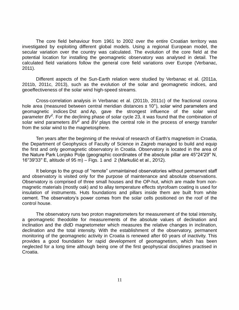
Ten years after the beginning of the revival of research of Earth's magnetism in Croatia, the Department of Geophysics of Faculty of Science in Zagreb managed to build and equip the first and only geomagnetic observatory in Croatia. Observatory is located in the area of the Nature Park Lonjsko Polje (geographic coordinates of the absolute pillar are 45°24'29'' N, 16°39'33'' E, altitude of 95 m) – Figs. 1 and 2 (Markušić et al., 2012).
It belongs to the group of “remote” unmaintained observatories without permanent staff and observatory is visited only for the purpose of maintenance and absolute observations. Observatory is comprised of three small houses and the OP-hut, which are made from non-magnetic materials (mostly oak) and to allay temperature effects styrofoam coating is used for insulation of instruments. Huts foundations and pillars inside them are built from white cement. The observatory’s power comes from the solar cells positioned on the roof of the control house.
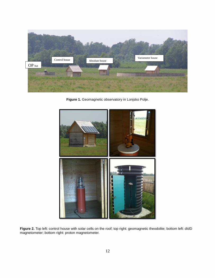
The observatory runs two proton magnetometers for measurement of the total intensity,
a geomagnetic theodolite for measurements of the absolute values of declination and inclination and the dIdD magnetometer which measures the relative changes in inclination, declination and the total intensity. With the establishment of the observatory, permanent monitoring of the geomagnetic activity in Croatia is renewed after 60 years of inactivity. This provides a good foundation for rapid development of geomagnetism, which has been neglected for a long time although being one of the first geophysical disciplines practised in Croatia.
12
Figure 1. Geomagnetic observatory in Lonjsko Polje.
Figure 2. Top left: control house with solar cells on the roof; top right: geomagnetic theodolite; bottom left: dIdD magnetometer; bottom right: proton magnetometer.
Absolute house
Control house
OP hut
Variometer house
13
From December 2012 we are hosting three-axial fluxgate magnetometer Lemi-035. It is a low-noise (< pT at 1 Hz) with 1 pT resolution at 1 Hz data rate with temperature drift < 0.5 nT/°C, installed under framework of the PLASMON Project (http://plasmon.elte.hu/home.htm) in cooperation with Tihany Observatory. List of publications
Lisac, I., Martinović, I. and Vujnović, V. (2011): Ruđer Bošković's insights about aurora borealis, published in the
treatise De aurora boreali (1738), International scientific symposium "Philosophy of Ruđer Josip Bošković", Šestak, I., Martinović, I. and Stanković, N. (Eds), Zagreb, Philosophy and Theology Institute of the Society of Jesus, Contributed Papers, p. 27-29 (in Croatian).
Markušić, S., Herak, D. and Mandić, I. (2012): First Croatian geomagnetic observatory in Lonjsko Polje, Kartografija i geoinformacije, 11, 194-199.
Verbanac, G. (2011): Modeling the geomagnetic field over Croatia. Geofizika, 28, 313-325. Verbanac, G. and Vujnović, V. (2011): Astronomy and planetology, In: M. Orlić, Z. Bencetić Klaić and M. Herak
(Eds): Nulla dies sine observatione – 150 years of the Geophysical Institute in Zagreb. Faculty of Science, Zagreb, 101-102 (in Croatian).
Verbanac, G., Mandea, M., Vršnak, B. and Sentić, S. (2011): Evolution of solar and geomagnetic activity indices, and their relationship: 1960 – 2001, Solar Physics, 271, 183-195.
Verbanac, G., Vršnak, B., Veronig, A. and Temmer, M. (2011): Equatorial coronal holes, solar wind high-speed streams, and their geoeffectiveness, Astronomy & Astrophysics, 526, A20-1-A20-13.
Verbanac, G., Vršnak, B., Živković, S., Hojsak, T., Veronig, A. and Temmer, M. (2011): Solar wind high-speed streams and related geomagnetic activity in the declining phase of solar cycle 23, Astronomy & Astrophysics, 533, A49-1-A49-6.
Verbanac, G. and Vujić, E. (2012): Determination of the Croatian geomagnetic observatory location, Acta Geophysica, 60, 337-356.
Verbanac, G., Živković, S., Vršnak, B., Bandić M. and Hojsak, T. (2013): Comparison of geoeffectiveness of coronal mass ejections and corotating interaction regions, Astronomy & Astrophysics, 558, A85-1-A85-10.
Vujić, E., Verbanac, G., Frančišković-Bilinski, S., Vujnović, V. and Marki, A. (2011): Estimation of the normal geomagnetic field and geological interpretation of the normal field anomalies over middle-northern Croatia, Studia Geophysica et Geodaetica, 55, 175-190.
Vujnović, V. (2011): How Rudjer Bošković determined height of polar lights, 7th Meeting of Croatian Physical Society, Primošten 13-16th October 2011, A. Gajović, V. Tokić, M. Zrnić, T. Maruščak (Eds), Book of Abstracts, p. 44 (in Croatian).
Vujnović, V. and Lisac, I. (2011): Ruđer Bošković and his findings about some phenomena in the earth atmosphere, 50th Anniversary of Medical Academy of Croatia (1961-2011), Zagreb, Ivanišević, G. (Ed), Contributed Papers, p. 11-14 (in Croatian).
Vujnović, V. and Lisac, I. (2011): What is subject of aeronomy, and is it investigated in Croatia, 7th Meeting of Croatian Physical Society, Primošten 13-16th October 2011, Gajović A., Tokić, V., Zrnić, M. and Maruščak, T. (Eds), Poster, Book of Abstracts, p. 44 (in Croatian).
Vujnović, V., Lisac, I. and Martinović, I. (2011): Historical and scientific commentary of Bošković’s dissertation De aurora boreali (1738), 20th Days of Frane Petrić, Croatian Philosophical Society, Zagreb 2011, Zagorac, I. and Martinović, I. (Eds), Contributed Papers, p. 183-186.
Vujnović, V. and Verbanac, G. (2011): Geomagnetism, In: M. Orlić, Z. Bencetić Klaić and M. Herak (Eds): Nulla dies sine observatione – 150 years of the Geophysical Institute in Zagreb. Faculty of Science, Zagreb, 96-99 (in Croatian).
Vujnović, V. and Lisac, I. (2013): De Aurora Boreali (1737) – Contemporary insight to the young Bošković’s treatise, Geofizika, 30, 99-118.
14
Hydrology in Croatia, 2011–2014
Report submitted to the International Association of Hydrological Sciences of the International Union of Geodesy and Geophysics
Vesna Denić-Jukić Faculty of Civil Engineering, Architecture and Geodesy, University of Split, Croatia
This report presents the research activities in the field of hydrology in Croatia in the period from 2011 to the end of 2014.
The research projects were funded by the Croatian Ministry of Science, Education and Sports. The scientific research was performed by experts from the following institutions:
Faculty of Civil Engineering, Univesity of Zagreb (1 project): 1. Torrential erosion of soils on the flysch of Istria (082-1780692-2164);
Faculty of Civil Engineering, Architecture and Geodesy, University of Split (3 projects): 1. Research of extreme hydrological situation and water risks in karst (083-0831510-1511); 2. Surface water and groundwater monitoring in coastal karst areas (083-0822695-1526); 3. Water balance and modeling of flow in karst (083-0831510-1513);
Faculty of Civil Engineering, University of Rijeka (1 project): 1. Hydrology of sensitive water resources in karst (114-0982709-2549). These projects are mostly the continuation of previous investigations in the field of karst hydrology and hydrogeology. The primary focus of those projects is evidently the karst hydrology. The hydrology of karst terraines was recognized as a distinct subdivision of groundwater hydrology. Aquifers are characterized by the distribution and anisotropy of hydraulic conductivity among various rock units that make up aquifer.
The flow of karst springs is often variable, rising and falling in response to storms. The water flowing from a spring represents a composite of all inputs and flow systems. Those projects are mostly based on the use of spring hydrographs to characterize the karst aquifers. The researchers also dealt with the construction of flow models for karst aquifer.
Scientists have been included in activities of numerous international and domestic conferences and a number of scientific papers were published covering theoretical and practical topics in hydrology. Also, the obtained results from the investigations were published in domestic and in international journals (Journal of Hydrology, Hydrological Processes, Hydrological Sciences Journal, Water Resources Management, Environmental Earth Sciences, Journal of Hydroinformatics, Theoretical and Applied Climatology, Acta Carsologica).
Mostly, the papers are ralated to the numerical modelling, rainfall-runoff modeling in karst areas, water balance modelling, time series analysis, hydrometry of uninvestigated area
15
in karst, and the determination of hydrogeological properties of a complex Dinaric karst catchments.
The Croatian-Japanese bilateral scientific project entitled Risk Identification and Land-Use Planning for Disaster Mitigation of Landslides and Floods in Croatia commenced on 27 March 2009 within the Science and Technology Research Partnership for Sustainable Development (SATREPS). The SATREPS programme enabled joint research to be carried out by Japanese and Croatian scientists, while the programme funded international research exchange as well as donations for equipment required for implementation of the project's activities. The project was evaluated at approximately 4 million USD, funded by the Japanese government, and co-funded by the Ministry of Science, Education and Sports of the Republic of Croatia. The Japanese partner institutions of the project were: the University of Niigata (The Research Center for Natural Hazards and Disaster Recovery), the University of Kyoto (Disaster Prevention Research Institute, DPRI) and the non-profit organization International Consortium on Landslides (the ICL). Croatian partner institutions in the project included three Croatian universities: the University of Rijeka (Faculty of Civil Enginering), the University of Zagreb (Faculty of Mining, Geology and Petroleum, and the Faculty of Agriculture) and the University of Split (Faculty of Civil Engineering, Architecture and Geodesy), as well as the Croatian Geological Survey. The project lasted 5 years, with over 20 participating researchers from Japan and some 30 from Croatia. One of the the main objectives of the project was geohazard analysis and development of guidelines for application of the project's results within a zoning system. The purpose of this project was contribution to sustainable development through application of suitable measures in planning documents. The project's activities have been carried out in pilot-areas near cities where the three Croatian partner-universities are located, i.e. Zagreb, Rijeka and Split.
The whole scientific work regarding hydrology in Croatia is documented in the publications the list of which is attached to this report. The list contains scientific papers published in Croatian and international journals. List of publications Abdulaj, R., Milković, N., Oskoruš, D. i Vujnović, T. (2014): Velike vode donjeg toka rijeke Save tijekom svibnja
2014, Hrvatska vodoprivreda, 207, 14-16. Andreić, Ž., Šegon, D., Korlević, K., Novoselnik, F., Vida, D. and Skokić. I. (2013): Ten possible new showers
from the Croatian Meteor Network and SonotaCo datasets, WGN, 41 (4), 103-108. Andreić, Ž., Vida, D., Novoselnik, F., Šegon, D., Korlević, K., Matijević, F., Jašarević, Dž., Perkov, A. and Tudo,
C. (2013): August Iota Cetids, a possible new meteor shower in August, WGN, 41 (2), 40-42. Andreić, Ž., Gural, P.S., Šegon, D., Skokić, I., Korlević, K., Vida, D., Novoselnik, F. and Gostinski, D. (2014): The
results of CMN 2013 search for new showers across CMN and SonotaCo databases I., WGN, 42 (3), 90-97.
Andrić, I., Bonacci, O. i Jukić, B. (2013): Rezultati najnovijih hidroloških i geomorfoloških istraživanja Crvenog jezera kod Imotskog, Časopis za vodno gospodarstvo, 21 (86), 344-348.
Andrić, I. and Bonacci, O. (2014): Morphological study of Red Lake in Dinaric karst based on terrestrial laser scanning and sonar systems, Acta Carsologica, 43 (2-3), 229-239.
Bačani, A. i Posavec K. (2011): Metode operacijskih istraživanja u hidrogeologiji. Sveučilište u Zagrebu, Rudarsko-geološko-naftni fakultet, Zagreb, 123 str.
16
Bačani, A. i Vlahović, T. (2012): Hidrogeologija i primjena u graditeljstvu. Sveučilište u Splitu, Fakultet građevinarstva, arhitekture i geodezije, Split, 335 str.
Biondić, R., Biondić, B. and Meaški, H.(2012): Water supply spring zone Novljanska Žrnovnica (Croatia) – new quantities of drinking water in the conditions of salt water intrusion, Acta Carsologica, 41 (2-3), 253-264.
Biondić, B. i Biondić, R. (2013): Hidrogeologija Gorskog kotare, U: A. Pavić, ur.: Vode razvijaju Gorski kotar. Udruga za očuvanje hrvatskih voda i mora – Slap, Zagreb, 21-24.
Biondić, R., Biondić, B., Rubinić, J. and Meaški, H. (2013): Quality and quantity status and risk assessment of groundwater bodies in the karst area of Croatia, In: P. Maloszewski, S. Witczak and G. Malina, Eds.: Groundwater Quality Sustainability. International Association of hydrogeologists selected papers, CRC Press, Balkema, London, 163-172.
Biondić, B. i Biondić, R. (2014): Hidrogeologija dinarskog krša u Hrvatskoj. Geotehnički fakultet, Varaždin, 341 str.
Bonacci, O. (2011) Challenges in transboundary karst water resources management sharing data and information, In: J. Ganoulis, A. Aureli, J. Fried, Eds.: Transboundary Water Resources Management – A Multidisciplinary Approach. Wiley-WCH Verlag GmbH & Co. KGaA, Weinheim, 95-101.
Bonacci, O. i Oskoruš, D. (2011): Hidrološka analiza sigurnosti Zagreba od poplave vodama rijeke Save u novim uvjetima, Hrvatske vode: časopis za vodno gospodarstvo, 19 (75), 13-24.
Bonacci, O. i Roje Bonacci, T. (2011): Utjecaj injekcijske zavjese izvedene ispod brane i akumulacije Đale na ponašanje podzemne vode u kršu, Hrvatske vode: časopis za vodno gospodarstvo, 19 (78), 259-270.
Bonacci, O. (2012): Flood risk and social justice: From Quantitative to Qualitative Flood Risk Assessment and Mitigation by Zoran Vojinovic & Michael B. Abbott. IWA Publishing, London, Journal of Hydroinformatics, 15 (2), 620-621.
Bonacci, O. (2012): Hidrološka analiza uzimanja vode iz krškog izvora rijeke Jadro, Hrvatske vode: časopis za vodno gospodarstvo, 20 (79-80), 23-28.
Bonacci, O. (2012): Increase of mean annual surface air temperature in the Western Balkans during last 30 years, Vodoprivreda, 44 (255-257), 75-89.
Bonacci, O. i Andrić, I. (2012): Analiza najnovijih mjerenja izvršenih na Modrom jezeru kod Imotskog. Hrvatske vode: časopis za vodno gospodarstvo, 20 (79-80), 51-59.
Bonacci, O. and Roje-Bonacci, T. (2012): Impact of grout curtains on karst groundwater behaviour: an example from the Dinaric karst, Hydrological Processes, 26 (18), 2765-2772.
Bonacci, O., Dadić, T. i Tadić, L. (2012): Hidrološki aspekti pojave snijega u Hrvatskoj, Hrvatske vode: časopis za vodno gospodarstvo, 20 (81), 117-130.
Bonacci, O., Ljubenkov, I. and Knezić, S. (2012): The water on a small karst island: the island of Korčula (Croatia) as an example, Environmental Earth Sciences, 66 (5), 1345-1357.
Bonacci, O. (2013): Poljes, ponors and their catchments, In: A. Frumkin, Ed.: Treatise on Geomorphology, Vol. 6. Elsevier & Academic Press, Amsterdam, 112-120.
Bonacci, O. (2013): Zabrinjavajući hidrološki trendovi na slivu Plitvičkih jezera, Hrvatske vode: časopis za vodno gospodarstvo, 21 (84), 137-146.
Bonacci, O. (2013): Zabrinjavajući hidrološki trendovi na slivu Plitvičkih jezera – Dodatak, Hrvatske vode, 21 (85), 243-243.
Bonacci, O. i Roje Bonacci, T. (2013): Problemi koji su se pojavili pri izgradnji i funkcioniranju brana i akumulacija u kršu, Hrvatske vode: časopis za vodno gospodarstvo, 21 (85), 254-262.
Bonacci, O., Željković, I. and Galić, A. (2013): Karst rivers’ particularity: an example from Dinaric karst (Croatia/Bosnia and Herzegovina), Environmental Earth Sciences, 70 (2), 963-974.
Bonacci, O., Željković, I., Šakić Trogrlić, R. i Milković, J. (2013): Prilog raspravi o računanju srednjih temperatura zraka. Hrvatske vode: časopis za vodno gospodarstvo, 21 (84), 129-136.
Bonacci, O., Željković, I., Šakić Trogrlić, R. and Milković, J. (2013): Differences between true mean daily, monthly and annual air temperatures and air temperatures calculated with three equations: A case study from three Croatian stations, Theoretical and Applied Climatology, 114 (1/2), 271-279.
Bonacci, O. (2014): Man’s influence on the water and ecological regimes in the Dinaric karst, In: N. Kukurić, Z. Stevanović and N. Krešić, Eds.: International Conference and Field Seminar "Karst Without Boundaries" Proceedings. Grafokomerc AD Trebinje, Trebinje, 334-341.
Bonacci, O. (2014): Ecohydrology of karst poljes and their vulnerability, In: P. Sackl, R. Durst, D. Kotrošan and B. Stumberger, Eds.: Dinaric Karst Poljes – Floods for Life. Euronatur, Radolfzell, 25-37 pp.
17
Bonacci, O. (2014): Upravljanje vodnim resursima u novim uvjetima, U: S. Lukšić, ur.: Izazovi u graditeljstvu 2. Hrvatski savez građevinskih inženjera, Zagreb, 160-187.
Bonacci, O. (2014): Hidrološka analiza mjerenja izvršenih na vodomjernoj postaji Slavonski brod na rijeci Savi, Hrvatske vode: časopis za vodno gospodarstvo, 22 (89), 267-272.
Bonacci, O. (2014): Analiza varijacija razine vode jezera Vrana na otoku Cresu, Hrvatske vode: časopis za vodno gospodarstvo, 22 (80), 337-346.
Bonacci, O. (2014): Utjecaj erupcija vulkana na klimu, Hrvatske vode: časopis za vodno gospodarstvo, 22 (80), 347-351.
Bonacci, O. i Oskoruš, D. (2014): Analiza nekih hidroloških vidova evakuacije velikih voda na području grada Zagreba, Hrvatske vode: časopis za vodno gospodarstvo, 22 (87), 31-38.
Bonacci, O., Andrić, I. and Yamashiki, Y. (2014): The hydrology of Blue Lake in the Dinaric karst, Hydrological Processes, 28 (4), 1890-1898.
Bonacci, O., Fumet, M. i Šakić Trogrlić, R. (2014): Analiza vodnih resursa izvora Omble, Hrvatske vode: časopis za vodno gospodarstvo, 22 (88), 107-118.
Bonacci, O., Popovska, C. i Gešovska, V. (2014): Utjecaj oborina i temperatura zraka na vodostaje Dojranskog jezera, Hrvatske vode: časopis za vodno gospodarstvo, 22 (89), 251-258.
Branković, Č., Patarčić, M., Güttler, I. and Srnec, L. (2012): Near-future climate change over Europe with focus on Croatia in an ensemble of regional climate model simulations, Climate Research, 52 (1), 227-251.
Branković, Č., Güttler, I. and Gajić-Čapka, M. (2013): Evaluating climate change at the Croatian Adriatic from observations and regional climate models’ simulations, Climate Dynamics, 41 (9/10), 2353-2373.
Branković, Č. (2014): Klima i klimatske promjene, Matematičko-fizički list, 3 (255), 152-162. Brkić, Ž., Urumović, K. and Briški, M. (2013): Post audit analysis of a groundwater level prediction model in
developed semiconfined aquifer system, Water Resources Management, 27 (9), 3349-3363. Cindrić, K. i Kalin, L. (2012): Analiza mogućnosti prognoze suše na području Hrvatske pomoću standardiziranog
oborinskog indeksa (SPI), Hrvatske vode: časopis za vodno gospodarstvo, 79 (80), 43-50. Cindrić, K., Nimac, I., Gajić-Čapka, M. i Rubinić, J. (2014): Vremenske promjene kratkotrajnih jakih oborina u
razdoblju 1955.-2010. za Split i Varaždin, Hrvatske vode: časopis za vodno gospodarstvo, 22 (89), 239-250.
Čanjevac, I. (2012): Novije promjene protočnih režima u hrvatskom dijelu poriječja Dunava, Hrvatski geografski glasnik, 74 (1), 61-74.
Čanjevac, I. (2013): Tipologija protočnih režima rijeka u Hrvatskoj, Hrvatski geografski glasnik, 75 (1), 23-42. Dadić, T., Jurišić, M. i Tadić L. (2014): Primjena GIS-a u gospodarenju otpadnim vodama, Tehnički vjesnik –
Technical Gazette, 21 (5), 1159-1163. Filipčić, A., Orešić, D. i Maradin, M. (2012): Utjecaj kontinentalnosti klime na dugogodišnje trendove količine
padalina u Hrvatskoj, Acta Geographica Croatica, 38, 15-24. Filipčić, A., Orešić, D. i Maradin, M. (2013): Promjene količine padalina u Hrvatskoj od sredine 20. stoljeća do
danas, Geoadria, 18 (1), 29-39. Gajić-Čapka, M. (2011): Snow climate baseline conditions and trends in Croatia relevant to winter tourism,
Theoretical and Applied Climatology, 105 (1/2), 181-191. Gajić-Čapka, M. and Cindrić, K. (2011): Secular trends in indices of precipitation extremes in Croatia, 1901–
2008, Geofizika, 28, 1-20. Gajić-Čapka, M. (2012): Klimatske informacije i klimatske promjene za potrebe upravljanja vodama, Hrvatska
vodoprivreda, 201, 22-26. Gajić-Čapka, M. (2013): Dnevne i višednevne oborine u srednjem i donjem toku rijeke Drave – klimatske
karakteristike i promjene, Hrvatske vode: časopis za vodno gospodarstvo, 21 (86), 285-294. Gajić-Čapka, M. i Cindrić, K. (2014): Pojava oborinskih ekstrema s osvrtom na poplave, Hrvatska vodoprivreda,
22, 96-99. Gajić-Čapka, M., Güttler, I. and Branković, Č. (2014): Climate and climate change analysis for the Island of
Korcula, Croatia, In: M. Kanakidou, N. Mihalopoulos and P. Nastos, Eds.: COMECAP 2014 E-book of Contributions. Crete University Press, Heraklion, 315-319.
Gajić-Čapka, M., Ožanić, N. and Krvavica, N. (2014): Estimation of maximum short-term precipitation over the Rijeka region, Elektronički časopis Građevinskog fakulteta Osijek, 5 (9), 49-59.
Gilja, G., Bekić, D. and Kuspilić, N. (2011): Comparison of flow velocity vectors collected by using RTK-GPS and bottom-tracking as a reference on a boat mounted ADCP, In: J. M. Sawicki and P. Zima, Eds.: Current
18
Events in Hydraulic Engineering. Gdansk University of Technology, Gdansk, 123-135. Gilja, G., Kuspilić, N. and Bekić, D. (2011): Impact of morphodynamical changes on the bridge stability: Case
study of Jakuševac Bridge in Zagreb, In: J. M. Sawicki and P. Zima, Eds.: Current Events in Hydraulic Engineering. Gdansk University of Technology, Gdansk, 112-122.
Holjević, D. (2011): Projekt navodnjavanja Canal de Navarra – model javno-privatnog partnerstva kao mogući smjer razvoja navodnjavanja, Hrvatska vodoprivreda, 19 (197), 26-28.
Holjević, D. i Petraš, J. (2011): Vrednovanje parametara erozije tla na području Istre, Hrvatske vode: časopis za vodno gospodarstvo, 19 (78), 251-259.
Holjević, D., Galiot, M., Brajković, A. i Bagarić, M. (2011): Provedba nacionalnog projekta navodnjavanja i gospodarenja poljoprivrednim zemljištem i vodama, Hrvatska vodoprivreda, 194 (1-3/2011), 44-46.
Holjević, D., Galiot, M., Brajković, A., Bagarić, M., Marušić, J. i Bašić, I. (2011): Nacionalni pilot projekt navodnjavanja Biđ-Bosutskog polja, Hrvatska vodoprivreda, 195 (04-06/2011), 32-35.
Horvat, B. (2013): Prostorna dinamika efektivne dnevne evapotranspiracije, Građevinar, 65 (8), 693-792. Horvat, B. (2014): Kartiranje poplavljene površine korištenjem optičkih satelitskih snimaka, Hrvatske vode:
časopis za vodno gospodarstvo, 22 (88), 166-171. Horvat, B. (2014): Daljinska istraživanja u monitoringu poplava, Hrvatska vodoprivreda, 22 (207), 113-115. Hunjak, T., Lutz, H.O. and Roller-Lutz, Z. (2013): Stable isotope composition of the meteoric precipitation in
Croatia, Isotopes in Environmental and Health Studies, 49 (3), 336-345. Josipović, M., Tadić, L., Tadić, Z. i Šreng, Ž. (2013): Zakonska regulativa vezana za vodu i navodnjavanje, U: M.
Josipović, ur.: Priručnik za navodnjavanje: za polaznike edukacije projekta IRRI, Poljoprivredni institut Osijek, Osijek, 27-39.
Jukić, D. and Denić-Jukić, V. (2011): Partial spectral analysis of hydrological time series, Journal of Hydrology, 400 (1/2), 223-233.
Kapelj, S. and Kapelj, J. (2013): Hydrogeological risk assessment of the catchment area, In: B. Obelić and I. Krajcar Bronić, Eds.: Croatia: Straval Case Study Plitvice Lakes National Park. Marie Curie Actions – IRSES Project STRAVAL, Barcelona, 28-33.
Kapelj, S., Loborec, J. and Kapelj, J. (2013): Assessment of the aquifer intrinsic vulnerability by the SINTACS method, Geologia Croatica, 2 (66), 119-128.
Karleuša, B. i Ožanić, N. (2011): Određivanje prioriteta u realizaciji vodnogospodarskih planova, Građevinar, 63 (2), 151-161.
Karleuša, B., Ožanić, N. and Deluka-Tibljaš, A. (2014): Improving decision making in defining priorities for implementation of irrigation plans using AHP methodology, Tehnički vjesnik, 21 (3), 673-680.
Krvavica, N., Mofardin, B., Ružić, I. i Ožanić, N., (2012): Mjerenje i analiza zaslanjivanja na ušću Rječine, Građevinar, 64 (11), 923-933.
Kuhta, M. (2011): Pazinska jama and its impacton the quality of springs in the valley of the river Raša, In: M. Prelovšek and N. Zupan Hajna, Eds.: Pressures and Protection of the Underground Karst – Cases from Slovenia and Croatia. Karst Research Institute ZRC SAZU, Postojna, 128-137.
Kunštek, D., Potočki, K. and Carević, I. (2011): Elaboration of CRR model for saturated soil on the example of flood wave on Botonega catchment, In: J. M. Sawicki and W. Szpakowski, Eds.: Ecohydrological Methods in Water Management. Gdansk University of Technology, Gdansk, 58-74.
Kuspilić, N., Gilja, G., Bekić, D. i Zubčić, K. (2013): Podvodni pregled stupova mostova i korita vodotoka, U: S. Lukšić, ur.: Mjerenja, ispitivanja i monitoring na prometnicama. Građevinski fakultet Sveučilišta u Zagrebu, Zagreb, 261-285.
Kuspilić, N., Oskoruš, D. i Vujnović, T. (2014): Katastrofalna poplava Save i poplavni rizici, Građevinar, 66 (7), 653-661.
Lukač Reberski, J., Marković, T. and Nakić, Z. (2013): Definition of the river Gacka springs subcatchment areas on the basis of hydrogeological parameters, Geologia Croatica, 66 (1), 39-53.
Ljubenkov, I. i Bonacci, O. (2011): Utvrđivanje i određivanje suše na otoku Korčuli, Hrvatske vode: časopis za vodno gospodarstvo, 19 (77), 181-194.
Mance, D., Hunjak, T., Lenac, D., Rubinić, J. and Roller-Lutz, Z. (2014): Stable isotope analysis of the karst hydrological systems in the Bay of Kvarner (Croatia), Applied Radiation and Isotopes, 90, 23-34.
Maradin, M. i Filipčić, A. (2012): Prostorne razlike u varijabilnosti padalina Središnje Hrvatske, Hrvatski geografski glasnik, 74, 41-59.
Maradin, M., Filipčić, A. i Orešić, D. (2012): Varijabilnost padalina u izabranim postajama na jadranskoj obali,
19
Acta Geographica Croatica, 38, 25-34. Maradin, M. (2013): Varijabilnost padalina na području Hrvatske s maritimnim pluviometrijskim režimom,
Geoadria, 18 (1), 3-27. Maradin, M., Madžar, I. i Perutina, I. (2014): Geografska raspodjela varijabilnosti padalina u Hrvatskoj i Bosni i
Hercegovini, Hrvatski geografski glasnik, 76 (2), 5-26. Marković, T., Brkić, Ž. and Larva, O. (2013): Using hydrochemical data and modelling to enhance the knowledge
of groundwater flow and quality in an alluvial aquifer of Zagreb, Croatia, Science of the Total Environment, 458 (460), 508-516.
Marković, T., Borović, S. and Larva O. (2015): Geochemical characteristics of thermal waters of Hrvatsko zagorje, Geologia Croatica, 68 (1), 67-77.
Marušić, J. (2011): Pet hrvatskih konferencija o vodama od 1995. do 2011. godine, Hrvatska vodoprivreda, 19 (196), 104-109.
Miklin Ž. and Slišković I. (2014): Water in karst catchments of Neretva and Cetina rivers, U: M. Horvat, ur.: Vode u kršu slivova Neretve i Cetine. Hrvatski geološki institut, Zagreb, 131-134.
Nakić, Z., Ružičić, S., Posavec, K., Mileusnić, M., Parlov, J., Bačani, A. and Durn, G. (2013): Conceptual model for groundwater status and risk assessment – case study of the Zagreb aquifer system, Geologia Croatica, 66 (1), 55-77.
Ožanić, N., Arbanas, Ž., Mihalić, S. and Marui, H., Eds. (2011): Monitoring and Analyses for Disaster Mitigation of Landslides, Debris Flow and Floods. Abstract Proceedings of the 2nd Japanese-Croatian Project Workshop. Sveučilište u Rijeci, Rijeka, 63 pp.
Ožanić, N., Karleuša, B. i Vidaković Šutić, R. (2012): Monografija Hrvatskog hidrološkog društva 1992-2012. Hrvatsko hidrološko društvo, Rijeka, 168 str.
Ožanić, N., Arbanas, Ž.; Mihalić, S., Marui, H. and Dragičević, N., Eds. (2012): Monitoring and Analyses for Disaster Mitigation of Landslides, Debris Flow and Floods. Book of Proceedings of the 2nd Japanese-Croatian Project Workshop. University of Rijeka, Rijeka, 185 pp.
Patrčević, V., Kopjar, A. i Đurin, B. (2014): Analiza infiltracije oborina na aluvijalnom tlu, Inženjerstvo okoliša, 1, 7-18.
Perčec Tadić, M., Gajić-Čapka, M., Gaćeša-Zaninović, K. and Cindrić, K. (2014): Drought vulnerability in Croatia, ACS. Agriculturae Conspectus Scintificus, 79 (1), 31-38.
Roller-Lutz, Z., Hunjak, T. and Lutz, H. O. (2013): Comment on the paper "Definition of the river Gacka springs subcatchment areas on the basis of hydrogeological parameters", Geologia Croatica, 66 (2), 151-151.
Rubinić, J. and Katalinić, A. (2014): Water regime of Vrana Lake in Dalmatia (Croatia) – changes, risks and problems, Hydrological Sciences Journal, 59 (10), 1908-1924.
Scitovski, R., Maričić, S. and Scitovski, S. (2012): Short-term and long-term water level prediction at one river measurement location, Croatian Operational Research Review, 3, 80-90.
Slišković, I. (2014): Water in Karst Catchments of Neretva and Cetina Rivers. Hrvatski geološki institut. Zagreb, 171 pp.
Šimunić, I. (2013): Uređenje voda. Hrvatska sveučilišna naklada, Zagreb, 260 str. Šperac, M. (2013): Flood risk management in Croatia, In: M. Zelenakova, Ed.: Hydrologic Risk – Floods and
Droughts. Technical University of Košice, Faculty of Civil Engineering, Košice, 70-81. Tadić, L. (2012): Criteria for evaluation of agricultural land suitability for irrigation in Osijek County Croatia, In: M.
Kumar, Ed.: Problems, Perspectives and Challenges of Agricultural Water Management. InTech, Rijeka, 311-332.
Tadić, L. (2013): Hidrološke i meteorološke podloge za navodnjavanje, U: M. Josipović, ur.: Priručnik za navodnjavanje za polaznike edukacije projekta IRRI. Poljoprivredni institut Osijek, Osijek, 68-75.
Tadić, L. (2013): Izvori vode i kvaliteta vode za navodnjavanje, U: M. Josipović, ur.: Priručnik za navodnjavanje za polaznike edukacije projekta IRRI. Poljoprivredni institut Osijek, Osijek, 76-79.
Tadić, L., Dadić T. and Barač, B. (2013): Flood frequency modelling of Kopački Rit nature park, Tehnički vjesnik – Technical Gazette, 20 (1), 51-57.
Tadić, L., Josipović, M., Plavšić, H. i Dadić, T. (2013): Posljedice nestručnog navodnjavanja i utjecaji navodnjavanja na okoliš, U: M. Josipović, ur.: Priručnik za navodnjavanje za polaznike edukacije projekta IRRI. Poljoprivredni institut Osijek, Osijek, 107-111.
Tadić, L., Bonacci, O. and Dadić, T. (2014): Dynamics of the Kopački Rit (Croatia) wetland floodplain water regime, Environmental Earth Sciences, 71 (8), 3559-3570.
20
Terzić, J., Stroj, A. and Frangen, T. (2012): Hydrogeologic investigation of karst system properties by common use of diverse methods: a case study of Lička Jesenica springs in Dinaric karst of Croatia, Hydrological Processes, 26 (21), 3302-3311.
Terzić, J. i Berović, N. (2013): Hidrogeološka obilježja sjeverozapadnog dijela Dugog otoka, U: A. Uglešić i J. Faričić, ur.: Veli Rat. Sveučilište u Zadru, Zadar, 62-82.
Terzić, J., Marković, T. and Lukač Reberski, J. (2014): Hydrogeological properties of a complex Dinaric karst catchment: Miljacka spring case study, Environmental Earth Sciences, 72 (4), 1129-1142.
Terzić, J., Lukač Reberski, J. and Rubinić, J. (2015): Groundwater protection and climate change predictions of a complex Dinaric karst catchment. A case study of the Bokanjac-Poličnik area, Croatia, In: G. Lollino, A. Manconi, J. Clague, W. Shan and M. Chiarle, Eds.: Engineering Geology for Society and Territory, Volume 1. Springer International Publishing, Switzerland, 95-98.
Urumović, K., Duić, Ž. and Hlevnjak, B. (2011): Impact of rainfall infiltration on groundwater recharge of the deep quaternary aquifer, Geologia Croatica, 64 (1), 17-30.
Vlahović, T. and Munda, B. (2012): Karst aquifers on small islands – the island of Olib, Croatia, Environmental Monitoring and Assessment, 184 (10), 6211-6228.
Volf, G., Ožanić, N. i Petrović, I. (2013): Upotreba GIS tehnologije u hidrologiji, Zbornik radova Građevinskog fakulteta Sveučilišta u Rijeci, 16, 1-18.
Žic, E., Bićanić, N., Koziara, T. and Ožanić, N. (2014): The numerical modelling of suspended sediment propagation in small torrents with the application of the contact dynamics method, Tehnički vjesnik, 21 (5), 939-952.
Žugaj, R., Andreić, Ž., Pavlić, K. i Fuštar, L. (2011): Krivulje trajanja protoka, Građevinar, 63 (12), 1061-1068.
21
Meteorology in Croatia, 2011–2014
Report submitted to the International Association of Meteorology and Atmospheric Sciences
of the International Union of Geodesy and Geophysics
Kristian Horvath1 and Branka Grbec2 1Meteorological and Hydrological Service, Zagreb, Croatia
2Institute of Oceanography and Fisheries, Split, Croatia
This report presents a brief overview of meteorological research in Croatia during the
2011-2014 interval, as evidenced by published editor’s books, book chapters, international peer-review (CC) publications and PhD theses. Over two dozens of nationally and internationally funded projects in this period were implemented at the Geophysics Department, Faculty of Science, University of Zagreb (GFZ), the Meteorological and Hydrological Service (DHMZ), the Physics Department, Faculty of Science, University of Split (PMFST), and the Institute of Oceanography and Fisheries (IOF) in Split. The research activity resulted in about eighty international peer-review (CC) publications and over a dozen of editor’s books and book chapters.
The research conducted by Croatian scientists covered a wide range of state-of-the-art topics in meteorology. Dynamical and synoptic meteorology focused on the analysis of mesoscale and synoptic systems, with a special emphasis on orographic flows and mesoscale cyclones in the area. Climatologists investigated past climate, climate variability and climate change, and evaluated and advanced the skill of regional climate models. Turbulence research predominantly dealt with turbulence in planetary boundary layer, especially during bora events, as well as turbulence in sub-urban areas. Intensive research has been performed on natural hazards related to hydrological cycle, especially convection, heavy precipitation and flash floods in Mediterranean but also in the tropics, especially through satellite, radar and lightening data, process-based studies and climatologies and numerical modelling. Methods for advancing numerical weather prediction focused on numerical instabilities, stiffness and phenomenology of parametrization schemes, the area of data assimilation, and verification of numerical weather predictions.
Furthermore, meteorological research intensively diffused to interdisciplinary research topics. Air-pollution studies addressed air-quality issues over complex topography and long-range transmission of air pollutants in our region as well as the related effects of climate change on air pollution. Air-sea-interaction studies dealt with land-sea breezes, effects of extreme weather events and climate on the dynamical sea processes near the coasts as well as monitoring of physical properties in the boundary layers of the atmosphere and the sea. Agrometeorologists investigated the effects of climate and adverse weather relevant for the field, especially yield of crops. Collaboration between meteorology and energy sectors was
22
stimulated through collaborative research in renewables, microgrids and energy efficiency in buildings. Other research topics considered were climate tourism, heat-waves effects on mortality, wildfires, refraction of radio-waves, estimates of wind extremes and loads on structures, statistical properties of hail, and homogenization of meteorological data.
More information on the conducted projects can be found on the web sites of GFZ (http://www.pmf.unizg.hr/geof), DHMZ (http://meteo.hr), PMFST (http://www.pmfst.unist.hr) and IOF (http://www.izor.hr).
List of publications
Bajić A. (2011): Prostorna raspodjela očekivanih maksimalnih brzina vjetra na složenom terenu Hrvatske kao
podloga za ocjenu opterećenja vjetrom. Doktorska disertacija, Sveučilište u Zagrebu, Zagreb, 109 str. Baklanov, A. A., Grisogono, B., Bornstein, R., Mahrt, L., Zilitinkevich, S. S., Taylor, P., Larsen, S. E., Rotach, M.
W. and Fernando, H. J. S. (2011): On nature, theory, and modelling of atmospheric planetary boundary layers, Bulletin of the American Meteorological Society, 92 (2), 123-128.
Barkiđija, S. and Fuchs, Ž. (2013): Precipitation correlation between convective available potential energy, convective inhibition and saturation fraction in middle latitudes, Atmospheric Research, 124, 170-180.
Belušić, D., Hrastinski, M., Večenaj, Ž. and Grisogono, B. (2013): Wind regimes associated with a mountain gap at the northeastern Adriatic coast, Journal of Applied Meteorology and Climatology, 52, 2089-2105.
Bencetić Klaić, Z., Pasarić, Z., Beg Paklar, G. and Oddo, P. (2011): Coastal sea responses to atmospheric forcings at two different resolutions, Ocean Science, 7, 521-532.
Bencetić Klaić, Z. (2012): The influence of meteorological conditions on fine particle (PM1.0) levels in the urban atmosphere, In: H.J. Fernando, Z. Bencetić Klaić and J. Mc Culley, Eds.: National Security and Human Health Implications on Climate Change. Springer, Dodrecht, 163-173.
Bencetić Klaić, Z and Kvakić, M. (2014): Modeling the impacts of a man-made lake on the meteorological conditions of the surrounding areas, Journal of Applied Meteorology and Climatology, 53 (5), 1121-1142.
Bice, D., Montanari, A., Vučetić, V. and Vučetić, M. (2012): The influence of regional and global climatic oscillations on Croatian climate, International Journal of Climatology, 32 (10), 1537-1557.
Blažica, V., Žagar, N., Strajnar, B. and Cedilnik, J. (2013): Rotational and divergent kinetic energy in the mesoscale model ALADIN, Tellus. Series A, Dynamic Meteorology and Oceanography, 65, 18918-1-18918-15.
Branković, Č., Patarčić, M., Güttler, I. and Srnec, L. (2012): Near-future climate change over Europe with focus on Croatia in an ensemble of regional climate model simulations, Climate Research, 52 (1), 227-251.
Branković, Č., Güttler, I. and Gajić-Čapka, M. (2013): Evaluating climate change at the Croatian Adriatic from observations and regional climate models’ simulations, Climate Dynamics, 41 (9/10), 2353-2373.
Brosy, C., Zaninović, K. and Matzarakis, A. (2014): Quantification of climate tourism potential of Croatia based on measured data and regional modeling, International Journal of Biometeorology, 58 (6), 1369-1381.
Cardinali, C., Žagar, N., Radnoti, G. and Buizza, R. (2014): Representing model error in ensemble data assimilation, Nonlinear Processes in Geophysics, 21, 971-985.
Comellas, A., Parodi, A., Fuchs, Ž. and Molini, L. (2013): Saturation fraction and gross moist stability in severely precipitating systems in the midlatitude Mediterranean environment, Atmospheric Research, 123, 360-367.
Cuxart, J., Jiménez, M. A., Telišman Prtenjak, M., and Grisogono, B. (2014): Study of a sea breeze case through momentum, temperature and turbulence budgets, Journal of Applied Meteorology and Climatology, 53 (11), 2589-2609.
Čalogović J. (2014): Utjecaj Sunčeve aktivnosti na Zemljin svemirski okoliš i klimu. Doktorska disertacija, Sveučilište u Zagrebu, Zagreb, 188 str.
Doyle, J. D., Gaberšek, S., Jiang, Q., Bernardet, L., Brown, J. M., Dörnbrack, A., Filaus, E., Grubišić, V., Kirshbaum, D. J., Knoth, O., Koch, S., Schmidli, J., Stiperski, I., Vosper, S. and Zhong, S. (2011): An intercomparison of T-REX mountain wave simulations and implications for mesoscale predictability,
23
Monthly Weather Review, 139 (9), 2811-2831. Drobinski, P., Ducrocq, V., Alpert, P., Anagnostou, E., Béranger, K., Borga, M., Braud, L., Chanzy, A., Davolio, S.,
Delrieu, G., Estournel, E., Filali Boubrahmi, N., Font, J., Grubišić, V., Gualdi, S., Homar, V., Ivančan-Picek, B., Kottmeier, C., Kotroni, V., Lagouvardos, K., Lionello, P., Llasat, M.C., Ludwig, W., Lutoff, C., Mariotti, A., Richard, E., Romero, R., Rottuno, R., Roussot, O., Ruin, I., Somot, S., Taupier-Letage, I., Tintore, J., Uijlenhoet, R. and Wernli, H. (2014): HyMeX, a 10-year multidisciplinary program on the Mediterranean water cycle, Bulletin of the American Meteorological Society, 10.1175/BAMS-D-12-00242.1, 1063-1082.
Fernando, H. J., Bencetić Klaić, Z. and McCulley, J., Eds. (2012): National Security and Human Health Implications of Climate Change. Springer, Dodrecht, 369 pp.
Fuchs, Ž., Gjorgjievska, S. and Raymond, D. J. (2012): Effects of varying the shape of the convective heating profile on convectively coupled gravity waves and moisture modes, Journal of the Atmospheric Sciences, 69 (8), 2505-2519.
Fuchs, Ž., Herman, M. J. and Raymond, D. J. (2014): Frictional convergence in a decaying weak vortex, Journal of the Atmospheric Sciences, 71, 2467-2475.
Fuchs, Ž., Sessions, S. L. and Raymond, D. J. (2014): Mechanisms controlling the onset of simulated convectively coupled Kelvin waves, Tellus. Series A, Dynamic Meteorology and Oceanography, 66, 170-180.
Gaćeša Zaninović K. (2011): Utjecaj ekstremnih termičkih prilika na smrtnost u Hrvatskoj. Doktorska disertacija, Sveučilište u Zagrebu, Zagreb, 139 str.
Gajić-Čapka, M. (2011): Snow climate baseline conditions and trends in Croatia relevant to winter tourism, Theoretical and Applied Climatology, 105 (1/2),181-191.
Gajić-Čapka, M., Güttler, I. and Branković, Č. (2014): Climate and climate change analysis for the Island of Korcula, Croatia, In: M. Kanakidou, N. Mihalopoulos and P. Nastos, Eds.: COMECAP 2014 E-book of Contributions. Crete University Press, Heraklion, 315-319.
Giorgi, F., Coppola, E., Solmon, F., Mariotti, L., Sylla, M. B., Bi, X., Elguindi, N., Diro, G. T., Nair, V., Giuliani, G., Cozzini, S., Güttler, I., O’Brien, T. A., Tawfik, A. B., Shalaby, A., Zakey, A. S., Steiner, A. L., Stordal, F., Sloan, L. C. and Branković, Č. (2012): RegCM4 model description and preliminary tests over multiple CORDEX domains, Climate Research, 52 (1), 7-29.
Grisogono, B. (2011): The angle of the near-surface wind-turning in weakly stable boundary layers, Quarterly Journal of the Royal Meteorological Society, 137 (656, Part A), 700-708.
Grisogono, B. and Axelsen, S. L. (2012): A note on the pure katabatic wind maximum over gentle slopes, Boundary-Layer Meteorology, 145, 527-538.
Güttler, I. and Belušić, D. (2012): The nature of small-scale non-turbulent variability in a mesoscale model, Atmospheric Science Letters, 13 (3), 169-173.
Güttler I. (2014): Systematic Errors in Regional Climate Models in the Lower Atmosphere. PhD Thesis, University of Zagreb, Zagreb, 109 pp.
Güttler, I., Branković, Č., O'Brien, T. A., Coppola, E., Grisogono, B. and Giorgi, F. (2014): Sensitivity of the regional climate model RegCM4.2 to planetary boundary layer parameterisation, Climate Dynamics, 43 (7/8), 1753-1772.
Güttler, I., Branković, Č., Srnec, L. and Patarčić, M. (2014): The impact of boundary forcing on RegCM4.2 surface energy budget, Climatic Change, 125 (1), 67-78.
Hengl, T., Heuvelink, G. B. M., Perčec Tadić, M. and Pebesma, E. (2012): Spatio-temporal prediction of daily temperatures using time-series of MODIS LST images, Theoretical and Applied Climatology, 107 (1/2), 265-277.
Herceg Bulić, I. (2012): ENSO Forcing of climate variability over the North Atlantic/European region in a warmer climate conditions, In: H.J. Fernando, Z. Bencetić Klaić and J. Mc Culley, Eds.: National Security and Human Health Implications on Climate Change. Springer, Dodrecht, 61-73.
Herceg Bulić, I. (2012): The sensitivity of climate response to the wintertime Niño3.4 sea surface temperature anomalies of 1855–2002, International Journal of Climatology, 32 (1), 22-32.
Herceg Bulić, I. and Kucharski, F. (2012): Delayed ENSO impact on spring precipitation over North/Atlantic European region, Climate Dynamics, 38 (11/12), 2593-2612.
Herceg Bulić, I., Branković, Č. and Kucharski, F. (2012): Winter ENSO teleconnections in a warmer climate, Climate Dynamics, 38 (7/8), 1593-1613.
24
Herceg Bulić, I. and Kucharski, F. (2014): North Atlantic SSTs as a link between wintertime NAO and the following spring climate, Journal of Climate, 27 (1), 186-201.
Horvath, K., Bajić, A. and Ivatek-Šahdan, S. (2011): Dynamical downscaling of wind speed in complex terrain prone to Bora-type flows, Journal of Applied Meteorology and Climatology, 50 (8), 1676-1691.
Horvath, K., Koračin, D., Vellore, R., Jiang, J. and Belu, R. (2012): Sub-kilometer dynamical downscaling of near-surface winds in complex terrain using WRF and MM5 mesoscale models, Journal of Geophysical Research, 117 (D11), A11111-1-A11111-19.
Horvath, K. and Vilibić, I. (2014): Atmospheric mesoscale conditions during the Boothbay meteotsunami: a numerical sensitivity study using a high-resolution mesoscale model, Natural Hazards, 74, 55-74.
Isotta, F.A., Frei, C., Weilguni, V., Perčec Tadić, M., Lassègues, P., Rudolf, B., Pavan, V., Cacciamani, C., Antolini, G., Ratto, S.M., Munari, M., Micheletti, S., Bonati, V., Lussana, C., Ronchi, C., Panettieri, E., Marigo, G. and Vertačnik, G. (2014): The climate of daily precipitation in the Alps: Development and analysis of a high-resolution grid dataset from pan-Alpine rain-gauge data, International Journal of Climatology, 34 (5), 1657-1675.
Ivančan-Picek, B. (2011): Duga; Pijavica; Polarna svjetlost, U: A. Bogutovac, ur.: Leksikon Ruđera Boškovića. Leksikografski zavod Miroslav Krleža, Zagreb, 28-98; 102-29; 100-104.
Ivančan-Picek, B., Horvath, K., Strelec Mahović, N. and Gajić-Čapka, M. (2014): Forcing mechanisms of a heavy precipitation event in the southern Adriatic area, Natural Hazards, 72 (2), 1231-1252.
Jansa, A., Alpert, P., Arbogast, P., Buzzi, A., Ivančan-Picek, B., Kotroni, V., Llasat, M.C., Ramis, C., Richard, E., Romero, R. and Speranza, A. (2014): MEDEX: a general overview, Natural Hazards and Earth System Sciences, 14, 1965-1984.
Jeričević, A., Fagerli, H. and Grisogono, B. (2012): Exploring the properties of local and non-local vertical diffusion schemes in the EMEP model using 222Rn data, International Journal of Environment and Pollution, 48 (1/4), 231-243.
Jeričević, A., Ilyin, I. and Vidič, S. (2012): Modelling of heavy metals: Study of impacts due to climate change, In: H.J. Fernando, Z. Bencetić Klaić and J. Mc Culley, Eds.: National Security and Human Health Implications on Climate Change. Springer, Dodrecht, 175-189.
Kilibarda, M., Hengl, T., Heuvelink, G. B.M., Graeler, B., Pebesma, E., Perčec Tadić, M. and Bajat, B. (2013): Spatio-temporal interpolation of daily temperatures for global land areas at 1 km resolution, Journal of Geophysical Research, 119 (5), 2294-2313.
Kozmar, H. and Bencetić Klaić, Z. (2012): Wind effects on man-made structures in a world with a changing climate, In: H.J. Fernando, Z. Bencetić Klaić and J. Mc Culley, Eds.: National Security and Human Health Implications of Climate Change. Springer, Dodrecht, 219-228.
Lalić, B., Eitzinger, J., Thaler, S., Vučetić, V., Nejedlik, P., Eckersten, H., Jacimovic, G. and Nikolić-Djorić; E. (2014): Can agrometeorological indices of adverse weather conditions help to improve yield prediction by crop models?, Atmosphere, 5 (4), 1020-1041.
Lepri, P., Kozmar, H., Večenaj, Ž. and Grisogono, B. (2014): A summertime near-ground velocity profile of the Bora wind, Wind and Structures, 19 (5), 505-522.
Likso T. (2012): Procjena brzine vjetra u suburbanom prizemnom sloju atmosphere. Doktorska disertacija, Sveučilište u Zagrebu, Zagreb, 98 str.
Likso, T. and Pandžić, K. (2012): Determination of surface layer parameters at the edge of a suburban area, Theoretical and Applied Climatology, 108 (3/4), 373-384.
Mastrangelo, D., Horvath, K., Riccio, A. and Miglietta, M. M. (2011): Mechanisms for convection development in a long-lasting heavy precipitation event over southeastern Italy, Atmospheric Research, 100 (4), 586-602.
Mikuš, P. and Strelec Mahović, N. (2012): Satellite-based overshooting top detection methods and an analysis of correlated weather conditions, Atmospheric Research, 123, 268-280.
Mikuš, P., Telišman Prtenjak, M. and Strelec Mahović, N. (2012): Analysis of the convective activity and its synoptic background over Croatia, Atmospheric Research, 104/105, 139-153.
Orlić, M., ur. (2011): Nulla dies sine observatione – 150 godina Geofizičkog zavoda u Zagrebu. Geofizički odsjek Prirodoslovno-matematičkog fakulteta Sveučilišta u Zagrebu, 231 pp.
Pasarić, Z. and Juras, J. (2011): Comments on ‘‘Applying a general analytic method for assessing bias sensitivity to bias-adjusted threat and equitable threat scores’’, Weather and Forecasting, 26 (1), 122-125.
Pašičko, R., Branković, Č. and Šimić, Z. (2012): Assessment of climate change impacts on energy generation
25
from renewable sources in Croatia, Renewable Energy, 46, 224-231. Patarčić, M. and Branković, Č. (2012): Skill of 2-m temperature seasonal forecasts over Europe in ECMWF and
RegCM models, Monthly Weather Review, 140 (4), 1326-1346. Patarčić, M., Gajić-Čapka, M., Cindrić, K. and Branković, Č. (2014): Recent and near-future changes in
precipitation-extreme indices over the Croatian Adriatic coast, Climate Research, 61 (2), 157-176. Počakal, D. (2011): Hailpad data analysis for the continental part of Croatia, Meteorologische Zeitschrift, 20 (4),
441-447. Počakal D. (2012): Energija zrna tuče u kontinentalnom dijelu Hrvatske. Doktorska disertacija, Sveučilište u
Zagrebu, Zagreb, 96 str. Podglajen, A., Hertzog, A., Plougonven, R. and Žagar, N. (2014): Assessment of the accuracy of (re)analyses in
the equatorial lower stratosphere, Journal of Geophysical Research – Atmosphere, 119, 11166-11188. Poljak, G., Telišman Prtenjak, M., Kvakić, M., Strelec Mahović, N. and Babić, K. (2014):
Wind patterns associated with the development of daytime thunderstorms over Istria, Annales Geophysicae, 32, 401-420.
Radović, A., Kati, V., Perčec Tadić, M., Denac, D. and Kotršan, D. (2014): Modelling the spatial distribution of the White Stork (Ciconia ciconia) breeding populations in the Southeast Europe, Bird Study, 61, 1-9.
Renko, T., Kozarić, T. and Tudor, M. (2012): An assessment of waterspout occurrence in the Eastern Adriatic basin in 2010: Synoptic and mesoscale environment and forecasting method, Atmospheric Research, 123 (1), 71-81.
Seletković, Z., Tikvić, I., Vučetić, M. i Ugarković, D. (2011): Klimatska obilježja i vegetacija sredozemne Hrvatske, U: S. Matić, ur.: Šume hrvatskoga sredozemlja. Akademija šumarskih znanosti, Zagreb, 142-161.
Sokol Jurković, R. and Pasarić, Z. (2013): Spatial variability of annual precipitation using globally gridded data sets from 1951 to 2000, International Journal of Climatology, 3 (3), 690-698.
Solazzo, E., Bianconi, R., Vautard, R., Appel, K. W., Bessagnet, B., Brandt, J., Christensen, J. H., Chemel, C., Denier van der Gon, I. C. H, Ferreira, J., Forkel, R., Xavier, V. F., Grell, G., Grossi, P., Hansen, A.B., Jeričević, A., Kraljević L., Miranda, A.I., Moran; M. D., Nopmongco, U., Pirovano, G., Prank M., Riccio, A., Sartelet, K. N., Schaap, M., Silver, J. D., Sokhi, R. S.,Vira, J., Werhahn, J., Wolke, R., Yarwood, G., Zhang, J., Rao, S. T. and Galmarini, S. (2012): Model evaluation and ensemble modelling of surface-level ozone in Europe and North America in the context of AQMEII, Atmospheric Environment, 53, 60-74.
Stiperski, I. and Grubišić, V. (2011): Trapped lee wave interference in presence of surface friction, Journal of the Atmospheric Sciences, 68 (4), 918-936.
Stiperski, I., Ivančan-Picek, B., Grubišić, V. and Bajić, A. (2012): The complex bora flow in the lee of Southern Velebit, Quarterly Journal of the Royal Meteorological Society, 138 (667/Part B), 1490-1506.
Strelec Mahović N. (2011): Prepoznavanje konvektivnih oblaka, magle i niskih oblaka te lociranje šumskih požara multispektralnom analizom satelitskih slika. Doktorska disertacija, Sveučilište u Zagrebu, Zagreb, 113 str.
Šepić, J., Vilibić, I. and Strelec Mahović, N. (2012): Northern Adriatic meteorological tsunamis: observations, link to the atmosphere and predictability, Journal of Geophysical Research, 117 (C2), C02002-1-C02002-18.
Telišman Prtenjak, M., Srnec, L., Peternel, R., Madžarević, V., Hrga, I. and Stjepanović, B. (2012): Atmospheric conditions during high ragweed pollen concentrations in Zagreb, Croatia, International Journal of Biometeorology, 56 (6), 1145-1158.
Telišman Prtenjak, M., Jeričević, A., Bencetić Klaić, Z., Alebić-Juretić, A. and Herceg Bulić, I. (2013): Atmospheric dynamics and the elevated ozone concentrations in the northern Adriatic, Meteorological Applications, 20 (4), 482-496.
Trnka, M., Olesen, J. E., Kersebaum, K. C., Skjelvåg, A. O., Eitzinge, J., Seguin, B., Peltonen-Sainio, P., Rötter, R., Iglesias, A., Orlandini, S., Dubrovský, M., Hlavinka, P., Balek, J., Eckersten, H., Cloppet, E., Calanca, P., Gobin, A., Vučetić, V., Nejedlik, P., Kumar, S., Lalić, B., Mestre, A., Rossi, F., Kozyra, J., Alexandrov, V., Semerádová, D. and Žalud, Z. (2011): Agroclimatic conditions in Europe under climate change, Global Change Biology, 17 (7), 2298-2318.
Tudor, M. (2012): A test of numerical instability and stiffness in the parametrizations of the ARPÉGE and ALADIN models, Geoscientific Model Development, 5 (4), 4233-4268.
Tudor, M. (2013): A test of numerical instability and stiffness in the parametrizations of the ARPÉGE and ALADIN models, Geoscientific Model Development, 6, 901-913.
Tudor, M., Ivatek-Šahdan, S., Stanešić, A., Horvath, K. and Bajić, A. (2013): Forecasting weather in Croatia
26
using ALADIN numerical weather prediction model, In: Y. Zhang and P. Ray, Ed.: Climate Change and Regional/Local Responses. InTech, Rijeka, 59-88.
Ulbrich, U., Lionello, P., Belušić, D., Jacobeit, J., Knippertz, P., Kuglitsch, F. G., Leckebusch, G. C., Luterbacher, J., Maugeri, M., Maheras, P., Nissen, K. M., Pavan, V., Pinto, J. G., Saaroni, H., Seubert, S., Toreti, A., Xoplaki, E. and Ziv, B. (2012): Climate of the Mediterranean: synoptic patterns, temperature, precipitation, winds, and their extremes, In: P. Lionello, Ed.: The Climate of the Mediterranean Region – From the Past to the Future. Elsevier, Amsterdam, 301-346.
Vautard, R., Moran, M. D., Solazzo, E., Gilliam, R. C., Matthias, V., Bianconi, R., Chemel, C., Ferreira, J., Geyer, B., Hansen, A. B., Jeričević, A., Prank, M., Segers, A., Silver, J, D., Werhahn, J., Wolke, R., Rao, S.T. and Galmarini, S. (2012): Evaluation of the meteorological forcing used for the Air Quality Model Evaluation International Initiative (AQMEII) air quality simulations, Atmospheric Environment, 53, 15-37.
Vautard, R., ..., Güttler, I., Patarčić, M., ... and Yiou, P. (2013): The simulation of European heat waves from an ensemble of regional climate models within the EURO-CORDEX project, Climate Dynamics, 41 (9/10), 2555-2575.
Večenaj, Ž., De Wekker, S. F.J. and Grubišić, V. (2011): Near-surface characteristics of the turbulence structure during a mountain-wave event, Journal of Applied Meteorology and Climatology, 50 (5), 1088-1106.
Večenaj Ž. (2012): Karakteristike turbulencije bure. Doktorska disertacija, Sveučilište u Zagrebu, Zagreb, 83 str. Večenaj, Ž., Belušić, D., Grubišić, V. and Grisogono, B. (2012): Along-coast features of the bora related
turbulence, Boundary-Layer Meteorology, 143, 527-545. Venema, V. K.C., Mestre, O., Aguilar, E., Auer, I., Guijarro, J. A., Domonkos, P., Vertačnik, G., Szentimrey, T.,
Stepanek, P., Zahradniček, P., Viarre, J., Muller-Westermeier, G., Lakatos, M., Williams, C. N., Menne, M., Lindau, R., Rasol, D., Rustemeier, E., Kolokythas, K., Marinova, T., Andersen, L., Acquaotta, F., Fratianni, S., Cheval, S., Klančar, M., Brunetti, M., Gruber, C., Prohom Duran, M., Likso, T., Esteban, P. and Brandsma, T. (2012): Benchmarking homogenization algorithms for monthly data, Climate of the Past, 8 (1), 89-115.
Viher M. (2011): Utjecaj troposferskih dinamičkih procesa na pojave nestandardne refrakcije radio valova. Doktorska disertacija, Sveučilište u Zagrebu, Zagreb, 82 str.
Viher, M. and Telišman Prtenjak, M. (2012): A multi-year study of radio-wave refractivity profiles above the Adriatic Sea up to an altitude of 40 km, Meteorologische Zeitschrift, 21 (4), 365-370.
Viher, M., Telišman Prtenjak, M. and Grisogono, B. (2013): A multi-year study of the anomalous propagation conditions along the coast of the Adriatic Sea, Journal of Atmospheric and Solar-Terrestrial Physics, 97, 75-84.
Vilibić, I., Horvath, K., Strelec Mahović, N., Monserrat, S., Marcos, M., Amores, A. and Fine, I. (2014): Atmospheric processes responsible for generation of the 2008 Boothbay meteotsunami, Natural Hazards, 74, 25-53.
Vučetić, V. (2011): Modelling of maize production in Croatia: present and future climate, Journal of Agricultural Science, 149 (2), 145-157.
Vučetić V. (2011): Modeliranje utjecaja klimatskih promjena na prinose kukuruza u Hrvatskoj. Doktorska disertacija, Sveučilište u Zagrebu, Zagreb, 107 str.
Wang, Y., Bellus, M., Wittmann, C., Steinheimer, M., Weidle, F., Kann, A., Ivatek-Šahdan, S., Tian, W., Ma, X., Tascu, S. and Bazile, E. (2011): The Central European limited-area ensemble forecasting system: ALADIN-LAEF, Quarterly Journal of the Royal Meteorological Society, 137 (655), 483-502.
Yano, J. I., Bister, M., Fuchs, Ž., Gerard, L., Phillips, V., Barkiđija, S. and Piriou, J. M. (2013): Phenomenology of convection-parameterization closure, Atmospheric Chemistry and Physics, 13, 4111-4131.
Zahradníček, P., Rasol, D., Cindrić, K. and Štěpánek, P. (2014): Homogenization of monthly precipitation time series in Croatia, International Journal of Climatology, 34 (14), 3671-3682.
Zaninović, K., and Matzarakis, A. (2014): Impact of heat waves on mortality in Croatia, International Journal of Biometeorology, 58 (6), 1135-1145.
Žagar, N., Skok, G. and Tribbia, J. (2011): Climatology of the ITCZ derived from ERA Interim reanalyses, Journal of Geophysical Research, 116, D15103-1-D15103-6.
Žagar, N., Tribbia, J., Anderson, J. L. and Raeder, K. (2011): Balance of the background-error variances in the ensemble assimilation system DART/CAM, Monthly Weather Review, 139 (7), 2061-2079.
Žagar, N. (2012): Multivariate data assimilation in the tropics by using equatorial waves, Pure and Applied Geophysics, 169 (3), 367-379.

27
Žagar, N., Terasaki, K. and Tanaka, H. L. (2012): Impact of the vertical resolution of analysis data on the estimates of large-scale inertio-gravity energy, Monthly Weather Review, 140, 2297-2307.
Žagar, N., Isaksen, L., Tan, D. and Tribbia, J. (2013): Balance properties of the short-range forecast errors in the ECMWF 4D-Var ensemble, Quarterly Journal of the Royal Meteorological Society, 139, 1229-1238.
Žagar, N., Honzak, L., Žabkar, R., Skok, G., Rakovec, J. and Ceglar, A. (2013): Uncertainties in a regional climate model in the midlatitudes due to the nesting technique and the domain size, Journal of Geophysical Research, 118, 12, 6189-6199.
28
Physical oceanography in Croatia, 2011–2014
Report submitted to the International Association for the Physical Sciences of the Oceans of the International Union of Geodesy and Geophysics
Gordana Beg Paklar Institute of Oceanography and Fisheries, Split, Croatia
Between 2011 and 2014 physical oceanographic research in Croatia has been carried out mainly in the following institutions: Institute of Oceanography and Fisheries (IOF), Split; Hydrographic Institute of the Republic of Croatia (HI), Split; Center for Marine Research (CMR), Rudjer Bošković Institute, Rovinj and Zagreb; Andrija Mohorovičić Geophysical Institute (AMGI), Faculty of Science, University of Zagreb; and Department of Electrical Engineering and Computing (DEEC), University of Dubrovnik.
Altogether 27 investigators (20 PhD's and 7 MSc's), supported by technical staff, were
involved in the research. Research vessels owned by institutes in Split (Bios dva, Navicula, Hidra, Palagruža) and Rovinj (Vila Velebita, Posejdon) were used in the field work. The oceanographic equipment used to study the hydrographic properties included several Seabird CTD probes, thermistor chains, XBTs and Biospherical profiling radiometer. A towed undulating vehicle, equipped by a Seabird CTD probe, has been acquired to perform hydrographic measurement of high temporal and spatial coverage. Currents were measured with a number of current meters (Aanderaa RCM's and RDI ADCP's) and high-frequency radars, while tide gauges (Ott analog instruments and Aanderaa, Ott and Parascientific digital instruments, radar Ott instrument) and wave gauges (Datawell, Seabird) were used to measure low- and high-frequency sea-level oscillations, respectively. Three buoys, designed and manufactured in Croatia, were deployed in the east Adriatic coastal areas in order to collect various meteorological and oceanographic data. Atmospheric conditions during oceanographic investigations were also recorded using microbarographs and an automatic meteo-oceanographic station in front of the Institute of Oceanography and Fisheries in Split. All institutions had a local computer network with a mainframe computer and a series of personal computers, connected to internet through Carnet (Croatian Academic Research Network). Moreover, complex ocean model simulations with POM, ROMS and MIKE models were run on computer clusters and servers.
During the four-year interval considered some previously established measurement
programs were maintained and some new were started. Thus, basic oceanographic data were collected on a monthly or seasonal basis all along the east Adriatic coast, as well as along some cross-shore transects (Rovinj-Po, Split-Gargano) within the framework of national projects and studies. Analyses of dynamic depths distribution and geostrophic currents became part of standard reports of a large national project developing an ecological model of the Adriatic Sea. In September 2012 the oceanographers from the AMGI carried out the first
29
high-resolution CTD measurements with the undulating vehicle, in the vicinity of the Cetina River mouth, on the eastern coast of the middle Adriatic. The profiling covered an 11 by 2.5 km radiator area, from near surface to some 35 m depth; the horizontal resolution was about 200 m along the track and the vertical resolution was better than 0.1 m. Another campaign of the towed CTD measurements was undertaken in July 2014 in the northern Adriatic, between Rovinj and Po and in front of the Po River mouth. Current measurements were performed within the second phase of the Adriatic Sea Monitoring Project and in the framework of various hydrotechnical projects (Drage, Smrka and Grška Bay in Brač Island). High-frequency radars were used for mapping surface currents and waves in the northern and middle Adriatic Sea within HAZADR project. Tide-gauge measurements were continued at a previously established network of seven stations (Rovinj, Bakar, Zadar, Split-Marjan, Split-harbour, Sućuraj, Dubrovnik), with some new stations being established temporarily (e.g. Ist). Sea-surface temperature was measured daily at a number of coastal stations. And finally, three microbarographs were installed at Vis, Vela Luka and Vrboska to provide high-frequency air-pressure data with the main goal to study and forecast meteotsunamis and sea surges.
Over the preceding four years Croatian institutions participated in national projects
founded by the Ministry of Science, Education and Sports of the Republic of Croatia, the Croatian Science Foundation and the Unity through Knowledge (UKF) fund. In addition to the research, physical oceanographers participated in series of professional studies dealing with physical parameters relevant to ecosystem and the categorizations of water within the European directives. Projects BALMAS, HAZADR and JASPPer were funded by IPA Adriatic Cross-border Cooperation Programme program, while SESAM, PERSEUS and SeaDataNet-II projects were supported by the European Community. Moreover, Croatian physical oceanographers participated in several international projects investigating areas outside the Adriatic, like the U.S. East coast (Horvath and Vilibić, 2014; Šepić and Rabinovich, 2014; Vilibić et al., 2014a, Vilibić et al., 2014b) and the Pacific Ocean (Powel et al., 2012; Matthews et al., 2012; Janeković and Powel, 2012; Janeković et al., 2013). Croatian physical oceanographers also took part in the IOC assemblies, GOOS and GODAR meetings, as well as in a number of international conferences and workshops.
The work done is documented in the publications the list of which is attached to this
report. The list contains scientific papers, books and theses. The 2011-2014 interval followed after the period of intense field measurements, done within the Croatian-American project ITHACA, when a large set of temperature, current and CTD data were gathered in the area of the Palarguža Sill. The analysis of the data revealed that large diurnal thermocline oscillations, observed at the Lastovo Island, were related to resonantly driven upwelling imposed by sea breeze circulation (Orlić et al., 2011). The response of the coastal sea to periodic along-shore and cross-shore wind forcing along a straight coast was studied by a simple analytical model. The wind at subinertial frequencies leads to coastally-trapped variability while at superinertial frequencies it leads to baroclinic inertia–gravity waves propagating away from the coast (Orlić and Pasarić, 2011). Under favourable stratification conditions internal coastally-trapped Kelvin-like waves that revolve in a clockwise direction around the island are also induced by periodic currents; depending on the perimeter of the island and the periodicity of the forcing, the resonance is achieved (Mihanović et al., 2014).
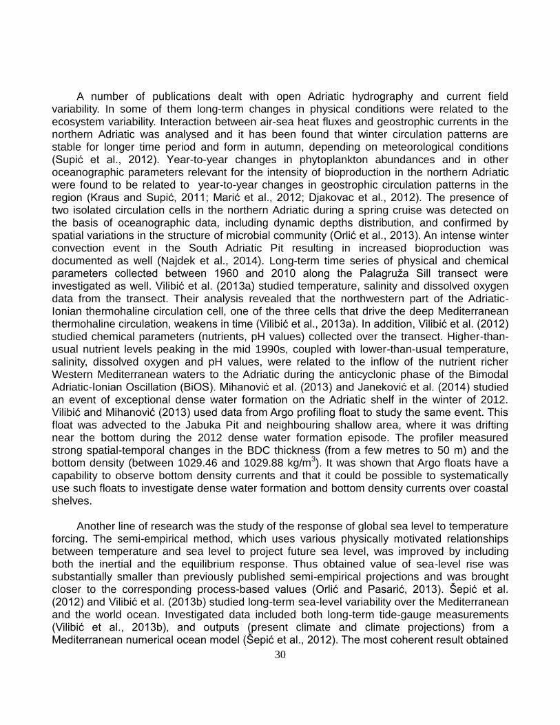
30
A number of publications dealt with open Adriatic hydrography and current field
variability. In some of them long-term changes in physical conditions were related to the ecosystem variability. Interaction between air-sea heat fluxes and geostrophic currents in the northern Adriatic was analysed and it has been found that winter circulation patterns are stable for longer time period and form in autumn, depending on meteorological conditions (Supić et al., 2012). Year-to-year changes in phytoplankton abundances and in other oceanographic parameters relevant for the intensity of bioproduction in the northern Adriatic were found to be related to year-to-year changes in geostrophic circulation patterns in the region (Kraus and Supić, 2011; Marić et al., 2012; Djakovac et al., 2012). The presence of two isolated circulation cells in the northern Adriatic during a spring cruise was detected on the basis of oceanographic data, including dynamic depths distribution, and confirmed by spatial variations in the structure of microbial community (Orlić et al., 2013). An intense winter convection event in the South Adriatic Pit resulting in increased bioproduction was documented as well (Najdek et al., 2014). Long-term time series of physical and chemical parameters collected between 1960 and 2010 along the Palagruža Sill transect were investigated as well. Vilibić et al. (2013a) studied temperature, salinity and dissolved oxygen data from the transect. Their analysis revealed that the northwestern part of the Adriatic-Ionian thermohaline circulation cell, one of the three cells that drive the deep Mediterranean thermohaline circulation, weakens in time (Vilibić et al., 2013a). In addition, Vilibić et al. (2012) studied chemical parameters (nutrients, pH values) collected over the transect. Higher-than-usual nutrient levels peaking in the mid 1990s, coupled with lower-than-usual temperature, salinity, dissolved oxygen and pH values, were related to the inflow of the nutrient richer Western Mediterranean waters to the Adriatic during the anticyclonic phase of the Bimodal Adriatic-Ionian Oscillation (BiOS). Mihanović et al. (2013) and Janeković et al. (2014) studied an event of exceptional dense water formation on the Adriatic shelf in the winter of 2012. Vilibić and Mihanović (2013) used data from Argo profiling float to study the same event. This float was advected to the Jabuka Pit and neighbouring shallow area, where it was drifting near the bottom during the 2012 dense water formation episode. The profiler measured strong spatial-temporal changes in the BDC thickness (from a few metres to 50 m) and the bottom density (between 1029.46 and 1029.88 kg/m3). It was shown that Argo floats have a capability to observe bottom density currents and that it could be possible to systematically use such floats to investigate dense water formation and bottom density currents over coastal shelves.
Another line of research was the study of the response of global sea level to temperature
forcing. The semi-empirical method, which uses various physically motivated relationships between temperature and sea level to project future sea level, was improved by including both the inertial and the equilibrium response. Thus obtained value of sea-level rise was substantially smaller than previously published semi-empirical projections and was brought closer to the corresponding process-based values (Orlić and Pasarić, 2013). Šepić et al. (2012) and Vilibić et al. (2013b) studied long-term sea-level variability over the Mediterranean and the world ocean. Investigated data included both long-term tide-gauge measurements (Vilibić et al., 2013b), and outputs (present climate and climate projections) from a Mediterranean numerical ocean model (Šepić et al., 2012). The most coherent result obtained
31
in these studies involved a significant decrease in sea-level variability over the tropical and subtropical Pacific, particularly at the synoptic scale frequencies (Vilibić et al., 2013b).
Croatian scientists within an international group managed a NOAA/NWS project
"Towards a meteotsunami warning system along the U.S. coastline (TMEWS)". Overall objective of the project was to build procedures and protocols for rising meteotsunami warning alerts along the U.S. coastline. As a result of this project a special Natural Hazards issues and a corresponding Springer book on meteorological tsunamis were issued (Vilibić et al., 2014). Several papers by Croatian oceanographers dealing mostly with meteotsunamis observed along the eastern U.S. coastline were published in this special issue (Horvath and Vilibić, 2014; Šepić and Rabinovich, 2014; Vilibić et al., 2014a, Vilibić et al., 2014b). In addition, Pasquet and Vilibić (2013) noticed that strongest meteotsunami waves hit the eastern U.S. 2-3 hours after atmospheric pressure disturbances cross the coastline. It was shown that offshore propagating atmospheric pressure disturbances resonantly generate long-ocean waves as they travel over the shallow shelf. Upon reaching the shelf edge, long-ocean waves are reflected back towards the coast where they can generate dangerous sea-level oscillations.
As a first step in assessing tsunami hazard in the Adriatic, a detailed study of historic
tsunamis from contemporary and original documents was carried out. The result of the study is a new catalog of Adriatic tsunamis (Pasarić et al., 2012).
New methods for measurements and analysis of the physical parameters were
introduced in the considered four-year period. A towed undulating vehicle, equipped by a Seabird CTD probe, has been used to perform quasi-synoptic 3D measurements of hydrographic properties near the Cetina River mouth. Results revealed a shallow fresh-water plume slightly warmer than the surrounding sea, with anticyclonic, cyclostrophic gyre formed in front of the mouth and a narrow coastal current extending downstream. A detailed study of the observed phenomena is still in progress. HF radars were used to map the surface currents in the northern and middle Adriatic. Mihanović et al. (2011) studied current measurements in the northern Adriatic from February to August 2009. Current patterns and temporal evolutions of different physical processes were extracted by using Self-Organizing Maps (SOM) analysis based on neural networks approach. A strong resemblance has been found between SOM patterns extracted from HF radar data only and from combined HF radar and wind data sets, revealing the predominant wind influence on the surface circulation structures and their temporal changes in the northern Adriatic. Results of this research served as a baseline idea for the UKF project "Interpreting and forecasting Adriatic surface currents by an artificial brain (NEURAL)". The aim of this ongoing project (2013-2015) is to investigate and develop a hybrid ocean forecasting system for the eastern coastal regions of the Adriatic Sea, based on the neural network approach. The SOM method was used not only in the study of high-frequency radar data but also to analyse long term changes in deep Adriatic water patterns (Vilibić et al., 2011) and underwater sound noise (Rako et al., 2013). Significant improvements in the algorithms for calculations of the satellite-derived sea surface temperatures in the Adriatic and Mediterranean were achieved by Tomažić et al. (2011, 2014).
32
Results of the numerical model simulations were used in a variety of research (Bencetić
Klaić et al., 2011; Orlić et al., 2011; Janeković et al., 2014; Mihanović et al., 2014) and application studies (Lončar et al. 2011; 2012). POM model was used to study the influence of the atmospheric forcing resolution on the simulation of coastal circulation, wind induced diurnal upwelling and internal tides, while ROMS model results revealed details in the exceptional dense water formation in the winter of 2012. Application studies on oil spills (Lončar et al., 2012) and effluent plume dynamics (Lončar et al., 2011) were performed with MIKE model. Coupled modelling system with ROMS and Wind Wave Model II was used in the analytical test case and to hindcast near-surface dynamics in the Adriatic (Dutour Sikirić et al., 2012; 2013).
Collaboration with chemists, biologists, fishery scientists and geologists was established,
resulting in number of interdisciplinary papers dealing with climate and circulation impact on the ecosystem variability (Skejić et al., 2014; Sikora et al., 2014; Gašparović et al., 2013; Gordijan et al., 2013; Marić et al., 2013; Rako et al., 2013; Viličić et al., 2013; Zorica et al., 2013; Carić et al., 2012; Vilibić et al., 2012; Kršinić and Grbec, 2012; Morović et al., 2012; Vidjak et al., 2012; Viličić et al., 2011). The Laboratory of Physical Oceanography at the Institute of Oceanography and Fisheries, Split, in cooperation with the State Hydrometeorology Institute of Croatia, has established a virtual laboratory (http://www.izor.hr/web/guest/virtual-laboratory) in order to study interactions between climate change and the marine ecosystem through monitoring of a variety of physical parameters in the atmosphere, the sea and at the air-sea interface. Through the interactive interface, the measured oceanographic data have been made available in a near real time, as were the weather forecasts at a 2x2 km grid over the Adriatic Sea.
Overall, increased number of scientists active in the Croatian physical oceanography
community and their intensified collaboration with colleagues abroad considerably improved scientific activity from 2011 to 2014 in comparison to the activities described in the previous reports to the International Association for the Physical Sciences of the Oceans. Improvement and modernization of the used equipment enabled new research topics to be addressed and important findings to be obtained. The list of publications as well as the number of realized and ongoing national and international projects for the Adriatic and the other ocean and coastal areas were significantly enlarged in comparison to the previous reporting intervals. Acknowledgement
Drs. N. Supić and M. Pasarić and Mr. M. Lakoš kindly supplied information on physical oceanographic activities of their institutions.
List of publications
Bencetić Klaić, Z., Pasarić, Z., Beg Paklar, G. and Oddo, P. (2011): Coastal sea responses to atmospheric
forcings at two different resolutions, Ocean Science, 7, 521-532.
33
Carić, M., Jasprica, N., Kršinić, F., Vilibić, I. and Batistić, M. (2012): Hydrography, nutrients, and plankton along the longitudinal section of the Ombla Estuary (Southeastern Adriatic), Journal of the Marine Biological Association of the United Kingdom, 92, 1227-1242.
Djakovac T., Degobbis, D., Supić, N. and R. Precali (2012): Marked reduction of eutrophication pressure in the northeastern Adriatic in the period 2000-2009, Estuarine, Coastal and Shelf Science, 115, 25-32.
Dutour Sikirić, M., Roland, A., Tomažić, I. and Janeković, I. (2012): Hindcasting the Adriatic Sea near-surface motions with a coupled wave-current model, Journal of Geophysical Research, 117 (C12), 10.1029/2012JC007950.
Dutour Sikirić, M., Roland, A., Janeković, I., Tomažić, I. and Kuzmić, M. (2013): Coupling of the Regional Ocean Modeling System (ROMS) and Wind Wave Model, Ocean Modelling, 72, 59-73.
Gašparović, B., Godrijan, J., Frka, S., Tomažić, I., Penezić, A., Marić, D., Djakovac, T., Ivančić, I., Paliaga, P., Lyons, D., Precali, R. and Tepić, N. (2013): Adaptation of marine plankton to environmental stress by glycolipid accumulation, Marine Environmental Research, 92, 120-132.
Godrijan, J., Marić, D., Imešek, M., Janeković, I., Schweikert, M. and Pfannkuchen, M. (2012): Diversity, occurrence, and habitats of the diatom genus Bacteriastrum (Bacillariophyta) in the northern Adriatic Sea, with the description of B. jadranum sp. nov., Botanica Marina, 55 (4), 415-426.
Godrijan, J., Marić, D., Tomažić, I., Precali, R. and Pfannkuchen, M. (2013): Seasonal phytoplankton dynamics in the coastal waters of the north-eastern Adriatic Sea, Journal of Sea Research, 77, 32-44.
Gomis, D., Tsimplis, M., Marcos, M., Fenoglio-Marc, L., Pérez, B., Raicich, F., Vilibić, I., Wöppelmann, G. and Monserrat, S. (2012): Mediterranean sea-level variability and trends, In: P. Lionello, Ed.: The Climate of the Mediterranean Region: From Past to the Future. Elsevier, Amsterdam, 257-299.
Horvath, K. and Vilibić, I. (2014): Atmospheric mesoscale conditions during the Boothbay meteotsunami: a numerical sensitivity study using a high-resolution mesoscale model, Natural Hazards, 74, 55-74.
Janeković, I. and Powell, B. (2012): Analysis of imposing tidal dynamics to nested numerical models, Continental Shelf Research, 34, 30-40.
Janeković, I., Powell, B.S., Matthews, D., McManus, M.A. and Sevadjian, J. (2013): 4D-Var data assimilation in a nested, coastal ocean model: A Hawaiian case study, Journal of Geophysical Research, 118, 5022-5035, doi: 10.1002/jgrc.20389.
Janeković, I., Mihanović, H., Vilibić, I. and Tudor, M. (2014): Extreme cooling and dense water formation estimates in open and coastal regions of the Adriatic Sea during the winter of 2012, Journal of Geophysical Research, 119, 3200-3218, doi:10.1002/2014JC009865.
Jozić, S., Morović, M., Šolić, M., Krstulović, N., and Ordulj, M. (2014): Effect of solar radiation, temperature and salinity on the survival of two different strains of Escherichia coli, Fresenius Environmental Bulletin, 23 (8), 1852-1859.
Kovač, Ž., Morović, M. and Matić, F. (2014): Uncovering spatial and temporal patterns of the Adriatic Sea color with self-organizing maps, International Journal of Remote Sensing, 35 (6), 2105-2117.
Kraus, R. and N. Supić (2011): Impact of circulation on high phytoplankton blooms and fish catch in the northern Adriatic (1990-2004), Estuarine, Coastal and Shelf Science, 91, 198-210.
Kršinić, F. and Grbec, B. (2012): Spatial distribution of copepod abundance in the epipelagic layer of the south Adriatic Sea, Acta Adriatica, 53 (1), 57-70.
Kuzmić, M. and Pasarić, Z. (2013): Fourier vs. wavelet analysis: the case of the Adriatic Sea surface temperature, Bilten Znanstvenog vijeća za daljinska istraživanja i fotointerpretaciju, 17, 5-19.
Kuzmić, M., Li, X.M., Grisogono, B., Tomažić, I. and Lehner, S. (2013): TerraSAR-X observations of the northeastern Adriatic bora: Early results, Acta Adriatica, 54 (1), 13-26.
Lasić, A., Jasprica, N., Morović, M., Kapetanović, T., Carić, M., Drešković, N., Glavić, N. and Mitić, B. (2014): Ecological characteristics of plant species and associations along two Dinaric karstic rivers (Bosnia and Herzegovina, the Balkans), Biologia, 69 (1), 40-52.
Lončar, G., Beg Paklar, G. and Janeković, I. (2011): Influence of density stratification on the effluent plume dynamics, Oceanologia, 53 (2), 565-585.
Lončar, G., Beg Paklar, G. and Janeković, I. (2012): Numerical modelling of oil spills in the area of Kvarner and Rijeka Bay (The Northern Adriatic Sea), Journal of Applied Mathematics, 2012, 49793-1-49793-20, doi: 10.1155/2012/497936.
Malanotte-Rizzoli, P., Artale, V., Borzelli-Eusebi, G. L., Brenner, S., Crise, A., Gačić, M., Kress, N., Marullo, S., Ribera d’Alcalà, M., Sofianos, S., Tanhua, T., Theocharis, A., Alvarez, M., Ashkenazy, Y., Bergamasco,
34
A., Cardin, V., Carniel, S., Civitarese, G., D’Ortnezio, F., Font, J., Garcia-Ladona, E., Garcia-Lafuente, J. M., Gogou, A., Gregoire, M., Hainbucher, D., Kontoyannis, H., Kovačević, V., Kraskapoulou, E., Kroskos, G., Incarbona, A., Mazzocchi, M. G., Orlić, M., Ozsoy, E., Pascual, A., Poulain, P.-M., Roether, W., Rubino, A., Schroeder, K., Siokou-Frangou, J., Souvermezglou, E., Sprovieri, M., Tintoré J. and Triantafyllou, G. (2014): Physical forcing and physical/biochemical variability of the Mediterranean Sea: a review of unresolved issues and directions for future research, Ocean Science, 10, 281-322.
Marić, D., Kraus, R., Godrijan, J., Supić, N., Djakovac, T. and Precali, R. (2012): Phytoplankton response to climatic and anthropogenic influences in the north-eastern Adriatic during the last four decades, Estuarine, Coastal and Shelf Science, 115, 98-112.
Matić, F. (2011): The Impact of Hemispheric Atmospheric Processes on Thermohaline Characteristics of the Adriatic Sea. PhD Thesis, University of Zagreb, Zagreb, 143 pp.
Matić, F., Grbec, B. and Morović, B. (2011): Indications of climate regime shifts in the Middle Adriatic Sea, Acta Adriatica, 52 (2), 235-246.
Matthews, D., Powell, B. and Janeković, I. (2012): Analysis of four-dimensional variational state estimation of the Hawaiian waters, Journal of Geophysical Research, 117, 10.1029/2011JC007575.
Mihanović, H., Cosoli, S., Vilibić, I., Ivanković, D., Dadić, V. and Gačić, M. (2011): Surface current patterns in the northern Adriatic extracted from high-frequency radar data using self-organizing map analysis, Journal of Geophysical Research, 116, 8033-8033 doi:10.1029/2011JC007104.
Mihanović, H., Vilibić, I., Carniel, S., Tudor, M., Russo, A., Bergamasco, A., Bubić, N., Ljubešić, Z., Viličić, D., Boldrin, A., Malačič, V., Celio, M., Comici, C. and Raicich, F. (2013): Exceptional dense water formation on the Adriatic shelf in the winter of 2012, Ocean Science, 9, 561-572.
Mihanović, H., Beg Paklar, G. and Orlić, M. (2014): Resonant excitation of island-trapped waves in a shallow, seasonally stratified sea, Continental Shelf Research, 77, 24-37.
Morović, M., Flander Putrle, V., Lučić, D., Grbec, B., Gangai, B., Malej, A. and Matić, F. (2012): Signatures of pigments and processes in the south Adriatic Sea- project MEDUZA, Acta Adriatica, 53 (3), 303-322.
Najdek M., Paliaga, P., Šilović, T., Batistić, M., Garić, R., Supić, N., Ivančić, I., Ljubimir, S., Korlević, M., Jasprica, N., Hrustić, E., Dupčić Radić, I., Blažina, M. and Orlić, S. (2014): Picoplankton community structure before, during and after convection event in the offshore waters of the southern Adriatic Sea, Biogeosciences, 11, 2645-2659.
Orlić, M. (2011): Wind-induced currents directed to the left of the wind in the northern hemisphere: An elementary explanation and its historical background, Geofizika, 28, 219-228.
Orlić, M. and Pasarić, Z. (2011): A simple analytical model of periodic coastal upwelling, Journal of Physical Oceanography, 41, 1271-1276.
Orlić, M., Beg Paklar, G., Dadić, V., Leder, N., Mihanović, H., Pasarić, M. and Pasarić, Z. (2011): Diurnal upwelling resonantly driven by sea breezes around an Adriatic island, Journal of Geophysical Research, 116, C09025-1-C09025-10, 10.1029/2011JC006955.
Orlić, M. and Pasarić, Z. (2013): Semi-empirical versus process-based sea-level projections for the twenty-first century, Nature Climate Change, 3, 735-738.
Orlić S., Najdek, M., Supić, N., Ivančić, I., Fuks, D., Blažina, M., Šilović, T., Paliaga, P., Godrijan, J. and Marić, D. (2013): Structure and variability of microbial community at transect crossing a double gyre structure (north-eastern Adriatic Sea), Aquatic Microbial Ecology, 69, 193-203.
Pasarić, M., Brizuela, B., Graziani, L., Maramai, A. and Orlić, M. (2012): Historical tsunamis in the Adriatic Sea, Natural Hazards, 61, 281-316.
Pasquet, S. and Vilibić, I. (2013): Shelf edge reflection of atmospherically generated long ocean waves along the central U.S. East Coast, Continental Shelf Research, 66, 1-8.
Pasquet, S., Vilibić, I. and Šepić, J. (2013): A survey of strong high-frequency sea level oscillations along the U.S. East Coast between 2006 and 2011, Natural Hazards and Earth System Sciences, 13, 473-482.
Powell, B.S., Janeković, I., Carter, G.S. and Merrifield, M.A. (2012): Sensitivity of internal tide generation in Hawaii, Geophysical Research Letters, 39(10), L10606-1-L10606, doi: 10.1029/2012GL051724.
Rako, N., Picciulin, M., Fortuna, C.M., Nimak Wood, M., Mackelworth, P., Pleslić, G., Holcer, D., Wiemann, A., Sebastianutto, L. and Vilibić, I. (2013): Leisure boating noise as a trigger for the displacement of the bottlenose dolphins of the Cres-Lošinj archipelago (northern Adriatic Sea, Croatia), Marine Pollution Bulletin, 68, 77-84.
Rako, N., Picciulin, M., Vilibić, I. and Fortuna, C.M. (2013): Spatial and temporal variability of sea ambient noise
35
as an anthropogenic pressure index: the case of the Cres-Lošinj archipelago, Croatia, Journal of the Marine Biological Association of the United Kingdom, 93, 27-36.
Rako, N., Vilibić, I. and Mihanović, H. (2013): Mapping the underwater sound noise and assess ing its sources by using a self-organizing maps method, Journal of the Acoustical Society of America, 133 (3), 1368-1376.
Roland, A., Zhang, Y., Wang, H., Meng, Y., Teng, Y.T., Maderich, V., Brovchenko, I., Dutour Sikirić, M. and Zanke, U. (2012): A fully coupled 3D wave-current interaction model on unstructured grids, Journal of Geophysical Research, 117, 1978-2012, doi: 10.1029/2012JC007952.
Sikora, M., Mihanović, H. and Vilibić, I. (2014): Paleo-coastline of the Central Eastern Adriatic Sea, and paleo-channels of the Cetina and Neretva rivers during the last glacial maximum, Acta Adriatica, 55 (1), 3-18.
Skejić, S., Bojanić, N., Matijevic, S., Vidjak, O., Grbec, B., Ninčević Gladan Ž., Šestanović. S and Šantić, D. (2014): Analysis of the phytoplankton community in the vicinity of domestic sewage outflow during stratified conditions, Mediterranean Marine Science, 15 (3), 574-586.
Supić, N., Kraus, R., Kuzmić, M., Paschini, E., Precali, R., Russo, A. and Vilibić, I. (2012): Predictability of northern Adriatic winter conditions, Journal Marine Systems, 90, 42-57.
Šepić, J. and Vilibić, I. (2011): The development and implementation of a real-time meteotsunami warning network for the Adriatic Sea, Natural Hazards and Earth System Sciences, 11, 83-91.
Šepić, J., Vilibić, I., Jordà, G. and Marcos, M. (2012): Mediterranean sea level forced by atmospheric pressure and wind: variability of the present climate and future projections for several period bands, Global and Planetary Change, 86-87, 20-30.
Šepić, J., Vilibić, I. and Strelec Mahović, N. (2012): Northern Adriatic meteorological tsunamis: Observations, link to the atmosphere, and predictability, Journal of Geophysical Research, 117, C02002-1-C02002-18, doi:10.1029/2011JC007608.
Šepić, J. and Rabinovich, A.B. (2014): Meteotsunami in the Great Lakes and on the Atlantic coast of the United States generated by the “derecho” of June 29–30, 2012, Natural Hazards, 74, 75-107.
Šilović, T., Ljubešić, Z., Mihanović, H., Olujić, G., Terzić, S., Jakšić, Z. and Viličić, D. (2011): Picoplankton composition related to thermohaline circulation: The Albanian boundary zone (southern Adriatic) in late spring. Estuarine, Coastal and Shelf Science, 91, 519-525.
Šupraha, L., Bosak, S., Ljubešić, Z., Mihanović, H., Olujić, G., Mikac, I. and Viličić, D. (2014): Cryptophyte bloom in a Mediterranean estuary: High abundance of Plagioselmis cf. prolonga in the Krka River estuary (eastern Adriatic Sea), Scientia Marina, 78 (3), 329-338.
Šupraha, L., Ljubešić, Z., Mihanović, H. and Henderiks, J. (2014): Observations on the life cycle and ecology of Acanthoica quattrospina Lohmann from a Mediterranean estuary, Journal of Nannoplankton Research, 34, 49-56.
Tomažić, I., Kuzmić, M., Notarstefano, G., Mauri, E. and Poulain, P.M. (2011): A comparative assessment of satellite-derived Adriatic Sea surface temperature, International Journal of Remote Sensing, 32 (17), 4871-4892.
Tomažić, I., Le Borgne, P. and Roquet, H. (2014): Assessing the impact of brightness temperature simulation adjustment conditions in correcting Metop-A SST over the Mediterranean Sea, Remote Sensing of Environment, 146, 214-233.
Vidjak, O., Bojanić, N., Matijević, S., Kušpilić, G., Ninčević Gladan, Ž. Skejić, S., Grbec, B. and Brautović, I. (2012): Environmental drivers of zooplankton variability in the coastal eastern Adriatic (Mediterranean Sea), Acta Adriatica, 53 (2), 243-262.
Vilibić, I., Mihanović, H., Šepić, J. and Matijević, S. (2011): Using Self-Organising Maps to investigate long-term changes in deep Adriatic water patterns, Continental Shelf Research, 31, 695-711.
Vilibić, I., Matijević, S., Šepić, J. and Kušpilić, G. (2012): Changes in the Adriatic oceanographic properties induced by the Eastern Mediterranean Transient, Biogeosciences, 9, 2085-2097.
Vilibić, I. and Mihanović, H. (2013): Observing the bottom density current over a shelf using an Argo profiling float, Geophysical Research Letters, 40, 910-915, doi:10.1002/grl.50215.
Vilibić, I., Šepić, J. and Proust, N. (2013): Weakening of thermohaline circulation in the Adriatic Sea, Climate Research, 55, 217–225.
Vilibić, I., Šepić, J. and Gaxotte, A. Z. (2013): Coherent patterns in long-term sea-level variability trends derived from long-term tide gauge measurements, International Journal of Climatology, 33, 577-584.
Vilibić, I., Mihanović, H. and Charrayre, F. (2014): Assessing meteotsunami potential of high-frequency air pressure oscillations observed in the middle Adriatic, Natural Hazards, 74, 217-232.
36
Vilibić, I., Horvath, K., Strelec Mahović, N., Monserrat, S., Marcos, M., Amores, A. and Fine, I. (2014): Atmospheric processes responsible for generation of the 2008 Boothbay meteotsunami, Natural Hazards, 74, 25-53.
Vilibić, I., Monserrat, S. and Rabinovich, A.B., Eds. (2014): Meteorological Tsunamis: the U.S. East Coast and Other Coastal Regions. Springer, Heidelberg, 303 pp.
Viličić, D., Šilović, T., Kuzmić, M., Mihanović, H., Bosak, S., Tomažić, I. and Olujić, G. (2011): Phytoplankton distribution across the southeast Adriatic continental and shelf slope to the west of Albania (spring aspect), Environmental Monitoring Assessment, 177, 593-607.
Viličić, D., Kuzmić, M., Tomažić, I., Ljubešić, Z., Bosak, S., Precali, R., Djakovac, T., Marić, D. and Godrijan, J. (2013): Northern Adriatic phytoplankton response to short Po River discharge pulses during summer stratified conditions, Marine Ecology an Evolutionary Perspective, 34 (4), 451-466.
Zorica, B., Vilibić, I., Čikeš Keč, V. and Šepić, J. (2013): Environmental conditions conducive to anchovy spawning in the Adriatic Sea, Fisheries Oceanography, 22, 32-40.
37
Seismology in Croatia, 2011–2014
Report submitted to the International Association of Seismology and Physics of the Earth’s Interior of the International Union of Geodesy and Geophysics
Davorka Herak and Marijan Herak University of Zagreb, Faculty of Science, Andrija Mohorovičić Geophysical Institute, Zagreb,
Croatia
Seismological research in Croatia is carried almost exclusively within the Department
of Geophysics, Faculty of Science, University of Zagreb. Scientific investigations were largely supported in the framework of two national projects, „Seismicity of Croatia“ and „Study of the geomagnetic field and heterogeneities of the lithosphere in Croatia“, which were financed by the Ministry of Science, Education and Sports of the Republic of Croatia. The staff of Croatian Seismological Survey (a part of the department) maintains and develops the networks of seismographs and of strong-motion instruments, compiles the earthquake catalogue and analyses and exchanges the seismological data. In the period 2011–2014 the number of seismological stations increased, as six new stations were opened (near Dubrovnik, in Makarska, Morići, Ozalj, Moslavačka gora and on Lastovo island). All of the existing stations have been set-up with digital broad-band instruments, and they transmit the data to the central observatory in Zagreb in real time. In total there are now 19 permanent seismological stations in Croatia.
Thirteen Croatian researchers (4PhD, 5 MSc and 4BSc) took part in seismological investigations. Two employees have retired after long service in the Croatian Seismological Survey (Vlado Kuk and Krešimir Marić) in October of 2013. In the period 2011–2014 a total of 13 research papers and the Croatian earthquake hazard map has been published. Researchers participated in 10 conferences with 12 conference communications. One doctoral thesis and six graduate theses were defended. Croatian seismologists were active in national and international scientific projects. For instance, the objective of the NATO SfP Project 984374 (Improvements in the Harmonized Seismic Hazard Maps for the Western Balkan Countries) is to improve the seismic hazard maps of the region using the project end products (seismotectonic and acceleometric database) and state-of-the art seismic hazard assessment methods. Croatian earthquake catalogue has been regularly updated and currently lists over 78,000 earthquake records (BC–2014), whereas the database on fault-plane solutions lists 224 events (Fig. 1).
The research topics included investigations of crustal and uppermost mantle structure by receiver functions (Stipčević et al., 2011). This study revealed that Moho beneath the southern Dinarides could lie at depth well over 55 km. Herak M. et al. (2011) compiled the seismic hazard map for the region of Croatia, which was adopted as a part of the national annex for the Eurocode-8 set of norms. Herak M. (2011) gave on overview of ambient noise
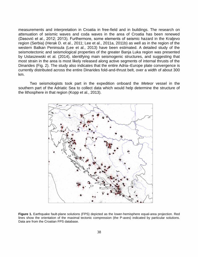
38
measurements and interpretation in Croatia in free-field and in buildings. The research on attenuation of seismic waves and coda waves in the area of Croatia has been renewed (Dasović et al., 2012; 2013). Furthermore, some elements of seismic hazard in the Kraljevo region (Serbia) (Herak D. et al., 2011; Lee et al., 2011a, 2011b) as well as in the region of the western Balkan Peninsula (Lee et al., 2013) have been estimated. A detailed study of the seismotectonic and seismological properties of the greater Banja Luka region was presented by Ustaszewski et al. (2014), identifying main seismogenic structures, and suggesting that most strain in the area is most likely released along active segments of internal thrusts of the Dinarides (Fig. 2). The study also indicates that the entire Adria–Europe plate convergence is currently distributed across the entire Dinarides fold-and-thrust belt, over a width of about 300 km.
Two seismologists took part in the expedition onboard the Meteor vessel in the southern part of the Adriatic Sea to collect data which would help determine the structure of the lithosphere in that region (Kopp et al., 2013).
Figure 1. Earthquake fault-plane solutions (FPS) depicted as the lower-hemisphere equal-area projection. Red lines show the orientation of the maximal tectonic compression (the P-axes) indicated by particular solutions. Data are from the Croatian FPS database.
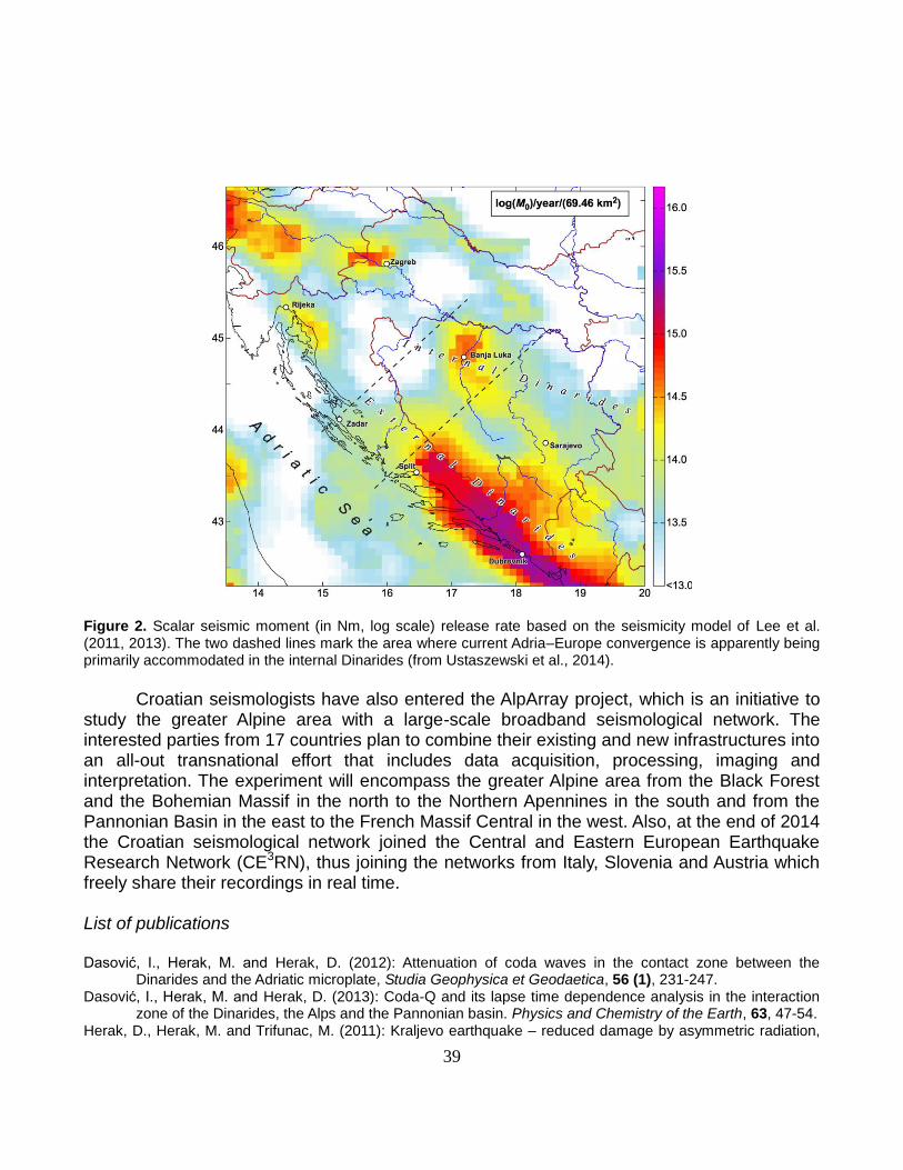
39
Figure 2. Scalar seismic moment (in Nm, log scale) release rate based on the seismicity model of Lee et al. (2011, 2013). The two dashed lines mark the area where current Adria–Europe convergence is apparently being primarily accommodated in the internal Dinarides (from Ustaszewski et al., 2014).
Croatian seismologists have also entered the AlpArray project, which is an initiative to
study the greater Alpine area with a large-scale broadband seismological network. The interested parties from 17 countries plan to combine their existing and new infrastructures into an all-out transnational effort that includes data acquisition, processing, imaging and interpretation. The experiment will encompass the greater Alpine area from the Black Forest and the Bohemian Massif in the north to the Northern Apennines in the south and from the Pannonian Basin in the east to the French Massif Central in the west. Also, at the end of 2014 the Croatian seismological network joined the Central and Eastern European Earthquake Research Network (CE3RN), thus joining the networks from Italy, Slovenia and Austria which freely share their recordings in real time. List of publications
Dasović, I., Herak, M. and Herak, D. (2012): Attenuation of coda waves in the contact zone between the
Dinarides and the Adriatic microplate, Studia Geophysica et Geodaetica, 56 (1), 231-247. Dasović, I., Herak, M. and Herak, D. (2013): Coda-Q and its lapse time dependence analysis in the interaction
zone of the Dinarides, the Alps and the Pannonian basin. Physics and Chemistry of the Earth, 63, 47-54. Herak, D., Herak, M. and Trifunac, M. (2011): Kraljevo earthquake – reduced damage by asymmetric radiation,
40
Izgradnja, 65 (5-6), 241-245. Herak, M. (2011): Overview of recent ambient noise measurements in Croatia in free-field and in buildings,
Geofizika, 28, 21-40. Herak, M., Allegretti, I., Herak, D., Ivančić, I., Kuk, V., Marić, K., Markušić, S. and Sović, I. (2011): Republika
Hrvatska, Karta potresnih područja, Eurocode 8: Design of Structures for Earthquake Resistance – Part 1: General Rules, Seismic Actions and Rules for Buildings – National Annex. Croatian Standards Institute, Zagreb, p 28.
Kopp, H., Dannowski, A., Argnani, A., Dasović, I., Dumke, I., Elger, J., Flueh, E.R., Frey, B., Handy, M., Karstens, J., Stipčević, J. et al. (2013): Adria Lithosphere Investigation Alpha – Cruise No. M86/3 – January 20 – February 04, 2012 – Brindisi (Italy) – Dubrovnik (Croatia), METEOR-Berichte, M86/3, 1-48.
Lee, V., Trifunac, M., Herak, M. and Herak, D. (2011): Minimum radius of seismic activity for earthquake hazard analyses, Izgradnja, 65 (5-6), 219-226.
Lee, V., Trifunac, M., Herak, M. and Herak, D. (2011): Uniform hazard earthquake acceleration spectra in Kraljevo – Contributions from local seismicity, Izgradnja, 65 (5-6), 227-235.
Lee, V., Herak, M., Herak, D. and Trifunac, M. (2013): Uniform hazard spectra in western Balkan Peninsula, Soil Dynamics and Earthquake Engineering, 55, 1-20.
Sović, I., Šariri, K. and Živčić, M. (2013): High frequency microseismic noise as possible earthquake precursor, Research in Geophysics, 3 (1), 8-12.
Stipčević, J., Tkalčić, H., Herak, M., Markušić, S. and Herak, D. (2011): Crustal and uppermost mantle structure beneath the External Dinarides, Croatia, determined from teleseismic receiver functions, Geophysical Journal International, 185 (3), 1103-1119.
Trifunac, M. and Herak, M. (2014): Earthquake vulnerability and engineering education, Izgradnja, 68 (5-6), 226-238.
Ustaszewski, K., Herak, M., Tomljenović, B., Herak, D. and Matej, S. (2014): Neotectonics of the Dinarides – Pannonian Basin transition and possible earthquake sources in the Banja Luka epicentral area, Journal of Geodynamics, 82, 52-68.


![(PDF) [In Croatian]](https://img.pdfslide.tips/doc/110x75/586782b01a28ab7b568b81af/pdf-in-croatian.jpg)