Embed Size (px)
Citation preview
Revision of Survey Results of Control Points after the 2011 off the Pacific Coast of Tohoku Earthquake
Yohei HIYAMA, Atsushi YAMAGIWA, Toshio KAWAHARA, Masao IWATA,
Yoshihiro FUKUZAKI, Yasushi SHOUJI, Yudai SATO, Toru YUTSUDO, Toshiyuki SASAKI, Hiromi SHIGEMATSU, Hiromi YAMAO, Takaaki INUKAI, Mitsuo OHTAKI,
Kensuke KOKADO, Shinobu KURIHARA, Isao KIMURA, Takashi TSUTSUMI, Toshihiro YAHAGI, Yukiko FURUYA, Isao KAGEYAMA, Satoshi KAWAMOTO,
Kazunori YAMAGUCHI, Hiromichi TSUJI and Shoichi MATSUMURA
Abstract
Large-scale crustal deformation over a wide area of eastern Japan was detected by GEONET, Japan's dense Global
Positioning System (GPS) network, following the 2011 off the Pacific coast of Tohoku Earthquake occurred on March 11,
2011. Since it was assumed that coordinates of the control points for public surveys, such as GEONET stations,
triangulation stations and leveling bench marks, in a wide area were greatly changed and could hardly maintain
consistency between nearby stations, the Geospatial Information Authority of Japan (GSI) stopped providing ‘Survey
Results’ of them, which were the coordinates for survey use, and announced it publicly on March 14, 2011.
In order to promote various public restoration programs in the affected area, it was strongly required to revise the
Survey Results in an urgent manner. On the other hand, because large postseismic deformation had continued widely after
the event, it was concerned that even if the Survey Results were updated immediately, they would become ineffective in a
short time. Therefore GSI examined the optimal timing to calculate their new coordinates by predicting the amount of future
postseismic movement based on the observation data of GEONET stations. Eventually, the new Survey Results of GEONET
stations were published on May 31, 2011 and those of triangulation stations and leveling bench marks on October 31, 2011
respectively.
In this paper we report the revision process of the Survey Results after the 2011 Tohoku Earthquake.
1. Stoppage of Provision of Survey Results of Control
Points
The 2011 off the Pacific coast of Tohoku Earthquake
(hereafter ‘Tohoku Earthquake’) was such a major seismic
event (Mw=9.0) that occurred at 05:46:23UT and triggered
a huge tsunami, causing severe and catastrophic damages
along the coast of Tohoku or Kanto district. On this event,
large-scale crustal deformation was detected by Japan's wide
and dense GPS observation network (GEONET), which had
been operated by Geospatial Information Authority of Japan
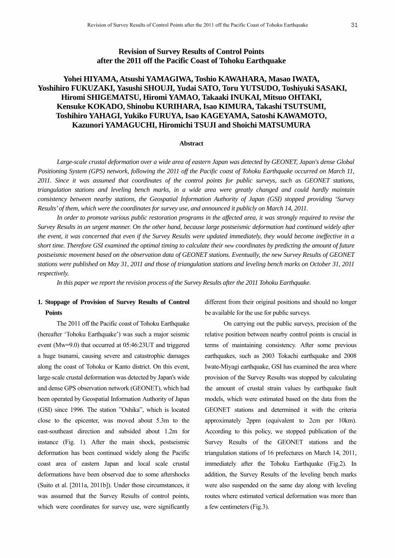
(GSI) since 1996. The station ”Oshika”, which is located
close to the epicenter, was moved about 5.3m to the
east-southeast direction and subsided about 1.2m for
instance (Fig. 1). After the main shock, postseismic
deformation has been continued widely along the Pacific
coast area of eastern Japan and local scale crustal
deformations have been observed due to some aftershocks
(Suito et al. [2011a, 2011b]). Under those circumstances, it
was assumed that the Survey Results of control points,
which were coordinates for survey use, were significantly
different from their original positions and should no longer
be available for the use for public surveys.
On carrying out the public surveys, precision of the
relative position between nearby control points is crucial in
terms of maintaining consistency. After some previous
earthquakes, such as 2003 Tokachi earthquake and 2008
Iwate-Miyagi earthquake, GSI has examined the area where
provision of the Survey Results was stopped by calculating
the amount of crustal strain values by earthquake fault
models, which were estimated based on the data from the
GEONET stations and determined it with the criteria
approximately 2ppm (equivalent to 2cm per 10km).
According to this policy, we stopped publication of the
Survey Results of the GEONET stations and the
triangulation stations of 16 prefectures on March 14, 2011,
immediately after the Tohoku Earthquake (Fig.2). In
addition, the Survey Results of the leveling bench marks
were also suspended on the same day along with leveling
routes where estimated vertical deformation was more than
a few centimeters (Fig.3).
Revision of Survey Results of Control Points after the 2011 off the Pacific Coast of Tohoku Earthquake 31
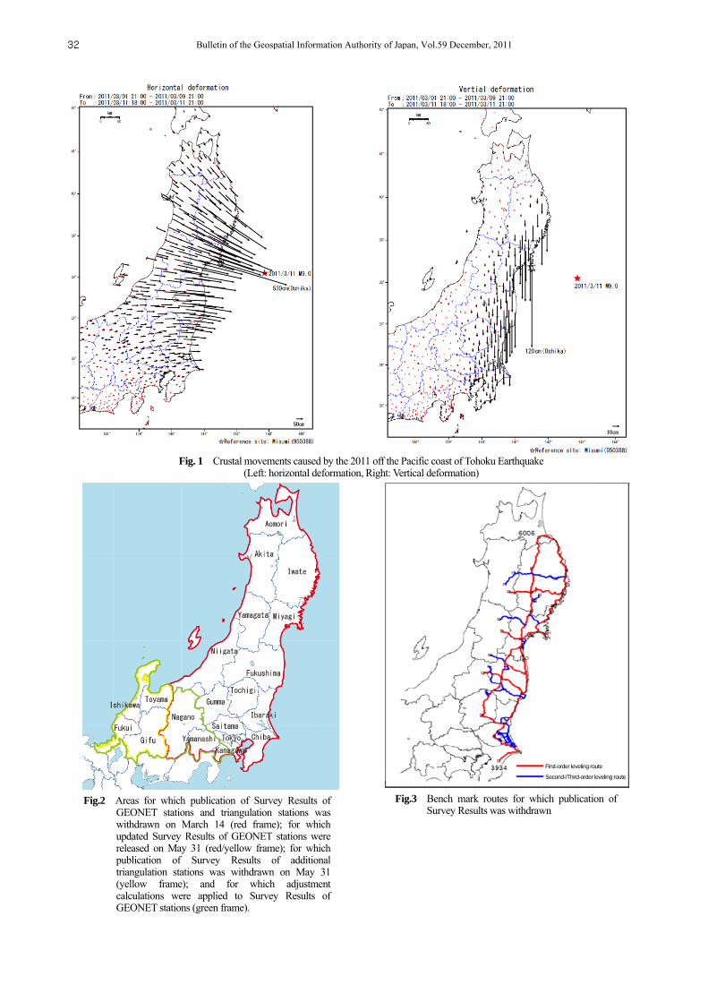
Fig. 1 Crustal movements caused by the 2011 off the Pacific coast of Tohoku Earthquake (Left: horizontal deformation, Right: Vertical deformation)
Fig.3 Bench mark routes for which publication ofSurvey Results was withdrawn
Fig.2 Areas for which publication of Survey Results of GEONET stations and triangulation stations was withdrawn on March 14 (red frame); for which updated Survey Results of GEONET stations were released on May 31 (red/yellow frame); for which publication of Survey Results of additional triangulation stations was withdrawn on May 31 (yellow frame); and for which adjustment calculations were applied to Survey Results of GEONET stations (green frame).
First-order leveling route
Second-/Third-order leveling route
Bulletin of the Geospatial Information Authority of Japan, Vol.59 December, 201132
In the course of evaluating the recalculated Survey
Results of GEONET stations, it came to light that in
addition to 16 prefectures, the Survey Results of Toyama,
Ishikawa, Fukui and Gifu prefectures were also needed to be
updated due to accumulated crustal strain. Therefore, we
additionally stopped provision of the Survey Results of
triangulation stations in these four prefectures on May 31
when the new Survey Results of GEONET stations were
released. The number of representative control points,
including ones with the suspended Survey Results after the
Tohoku Earthquake, is listed in Table 1.
Table 1 List of the number of control points across Japan and the
number of control points in 20 prefectures withheld from publication of survey results
2. Required Accuracy and Revision Date for the Survey
Results of GEONET Stations
In accordance with the tolerances indicated in the
General Standard of Operation Specifications for Public
Surveys, the accuracy required for calculating Survey
Results of GEONET stations should be to a point-to-point
relative accuracy of 2ppm.
Since positional data were necessary for
restoration/reconstruction of the disaster-stricken area, and
would also be utilized in resurvey of triangulation stations
and public control points, urgent revision of Survey Results
of GEONET stations was required. Meanwhile, to decrease
the effect of postseismic deformation, future deformation
was estimated based on the observation data of GEONET
stations using the approximation formula with a logarithm
function by Marone et al. [1991] as follows:
log1ln
tacty ,
where c and a are the constants, τlog is the time constant and t
is the time elapsed from the earthquake.
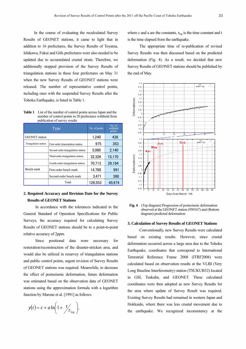
The appropriate time of re-publication of revised
Survey Results was then discussed based on the predicted
deformation (Fig. 4). As a result, we decided that new
Survey Results of GEONET stations should be published by
the end of May.
Fig. 4 (Top diagram) Progression of postseismic deformation
observed at the GEONET station (950167) and (Bottom diagram) predicted deformation
3. Calculation of Survey Results of GEONET Stations
Conventionally, new Survey Results were calculated
based on existing results. However, since crustal
deformation occurred across a large area due to the Tohoku
Earthquake, coordinates that correspond to International
Terrestrial Reference Frame 2008 (ITRF2008) were
calculated based on observation results at the VLBI (Very
Long Baseline Interferometry) station (TSUKUB32) located
in GSI, Tsukuba, and GEONET. These calculated
coordinates were then adopted as new Survey Results for
the area where update of Survey Result was required.
Existing Survey Results had remained in western Japan and
Hokkaido, where there was less crustal movement due to
the earthquake. We recognized inconsistency at the
Type No. of points No. of
withheld points
GEONET station 1,240 438
Triangulation station First-order triangulation station 975 353
5,060 2,140
32,326 15,170
70,713 26,194
Bench mark 14,768 991
3,471 388 Total 128,553 45,674
Second-order triangulation station
Third-order triangulation station
Fourth-order triangulation station
First-order bench mark
Second-order bench mark
Revision of Survey Results of Control Points after the 2011 off the Pacific Coast of Tohoku Earthquake 33

boundaries between the existing and updated Survey Results
and corrected them with the model described in 3.1.3 to
ensure the required accuracy for surveys.
3.1 Calculation of Survey Results Based on VLBI and
GEONET
3.1.1 Coordinates of TSUKUB32
The coordinate of TSUKUB32 on ITRF2008 was
estimated on the analysis of VLBI observation data of
international VLBI session "IVS-R1482", which was
conducted on May 10, to adopt the latest coordinates for the
revision of the Survey Results. Table 2 shows the detail of
the observation data. The session result of IVS-R1482 was
acquired from the IVS data center and then analyzed using
VLBI Analysis Software "Calc/Solve" (Table 3). We
constrained the ITRF 2008 coordinates of five overseas
stations, which were not affected by the earthquake, and the
coordinates of TSUKUB32 were calculated.
3.1.2 Survey Results Calculation Method
The calculation method for Survey Results with
observation results of the VLBI and GEONET is as follows
(Fig. 5).
First, the postseismic deformation was calculated from
the difference in averages of R3 solutions at the GEONET
Station 92110 (located in GSI, Tsukuba) between May 8-12
and May 22-26. Next, we calculated the coordinate of
TSUKUB32 at 12:00 UTC, May 24 by adding the
postseismic deformation to the coordinate calculated from
VLBI observation at 5:00 UTC, May 10.
Table 2 International VLBI observation data (IVS-R1482)
Session name IVS-R1482
Observation time 2:00 a.m., May 10, 2011
to 2:00 a.m., May 11, 2011 (Japan time)
Participating station TSUKUB32 (Tsukuba, Japan)
HOBART26 (Australia)
KOKEE (U.S.)
MATERA (Italy)
NYALES20 (Norway)
WETTZELL (Germany)
The coordinates (ITRF2005) at 12:00 UTC, May 24 were
calculated by averaging the R3 solution data in May 23-25.
Then, we transformed the reference frame from ITRF2005
to ITRF2008.
Fig. 5 Calculation of Survey Results with VLBI and GEONET
Analysis software
CALC/SOLVE release of 2010.05.21
Estimated parameter
Station coordinates (ITRF2008)
X,Y,Z
Radio source (Partial)
RA, declination
Earth orientation parameter
Polar motion (X,Y,Xdot,Ydot) Earth rotation speed (dUT1,dUT1dot) Nutation offset (dPsi,deps)
Zenith wet delay Estimated every 20 minutes
Relative time-scale change
Estimated every 60 minutes
Atmospheric gradient
Estimated every 8 hours
A priori
Station coordinates, speed
ITRF2008 (Altamimi et al., 2011)
Radio source ICRF2 (Fey et al., 2009)
Earth orientation parameter
USNO Finals from NASA/GSFC on 2011.05.25 (Godard Geodetic VLBI Group’s web pages)
Ocean-tide loading model
Ocean loading model “2007b_oclo.hps”from NASA/GSFC (Petrov et al., 2003)
Mapping function
NMF dry mapping Function (Niell et al., 1996)
Table 3 VLBI observation data analysis conditions
Bulletin of the Geospatial Information Authority of Japan, Vol.59 December, 201134
Lastly, we combined and with the collocation result
in 2007 (Miura et al. [2009]) and shifted the R3 solutions so
that they were consistent with the coordinate of TSKB
based on VLBI. The shifted R3 solutions (R3’ solutions)
were used as new Survey Results of GEONET stations that
are located in the area for which publication of Survey
Results had been stopped. To obtain the elevations of them,
Japanese Geoid Model 2000 (Nakagawa et al. [2002]) was
subtracted from ellipsoidal heights of each GEONET
station.
3.1.3 Adjustment Calculations on Boundary Area
Discrepancies across the boundaries of areas with
updated Survey Results and those with no updates had been
caused by accumulated crustal strain since January 1, 1997
when Geodetic Coordinates 2000 was published. Thus, we
calculated correction values for the revised Survey Results
so that the amount of discrepancy across the boundaries
became 2ppm or smaller. Since the strait lies between the
main island of Japan and Hokkaido, corrections were
applied to only western boundaries region (hereafter
‘corrected area’) (Fig. 2). The corrections were not applied
for the elevations, because they were confirmed to satisfy
the tolerances specified in General Standard of Operation
Specifications for Public Surveys.
(1) Calculation of an approximate plane for latitude and
longitude adjustments
First we assumed the discrepancies decrease linearly with
the distance from the boundary and fitted them by planes by
choosing fixed points outside the corrected area. The
correction value planes are modeled as follows:
iiii dBbLraBr , iiii dLnLrmBr ,
where (dBi, dLi) are the differences in latitude and longitude
respectively between in Geodetic coordinates 2000 and the
R3’ solutions at i-th fixed point, and (Bri, Lri) are the latitude
and longitude at i-th fixed point. Specifically, we assumed
the differences at the fixed points are zero on the eastern
side (the area targeted for revision) and are equal to the
average of differences in Geodetic Coordinates 2000 and
R3’ solutions on the western side (the area not targeted for
revision) which were calculated in 3.1.2. The least squares
method requires:
02
iia
, 02
iib
.
Then we derived correction parameters a and b for the
latitudes:
iii
iii
i iiii
i iiii
dBLr
dBBr
BrLrBr
LrBrLr
Ab
a2
2
222
1
i
iii i
ii LrBrLrBr
A
.
For the longitudes, the correction parameters m and n were
calculated in the same way.
(2) Refinement through weighting with spherical distance
Next we refined the model using residuals from the
approximate plane at each point in the corrected area. The
model was refined through weighting by the reciprocal of
the square of the spherical distance Dij between each fixed
point used in 3.1.3(1) and each point in the corrected area.
The direction cosine of fixed point at (Bri, Lri) is:
iiiiiiii BrLrBrLrBrzyx sin,sincos,coscos,, .
The direction cosine of each point at (Brj, Lrj) in the
corrected area is:
jjjjjjjj BrLrBrLrBrzyx sin,sincos,coscos,, .
Then, the distance Dij between them on the unit sphere is:
jijijiij zzyyxxD arccos.
From these equations, the final correction values (Bj, Lj)
at each GEONET station within the corrected area are:
ijj
i ij
i ij
i
j dBbLraBr
D
DdB
B
2
2
1
ijj
i ij
i ij
i
j dLnLrmBr
D
DdL
L
2
2
1
.
Revision of Survey Results of Control Points after the 2011 off the Pacific Coast of Tohoku Earthquake 35
The final new Survey Results were concluded by
adding (Bj, Lj) to the R3’ solutions in the corrected area.
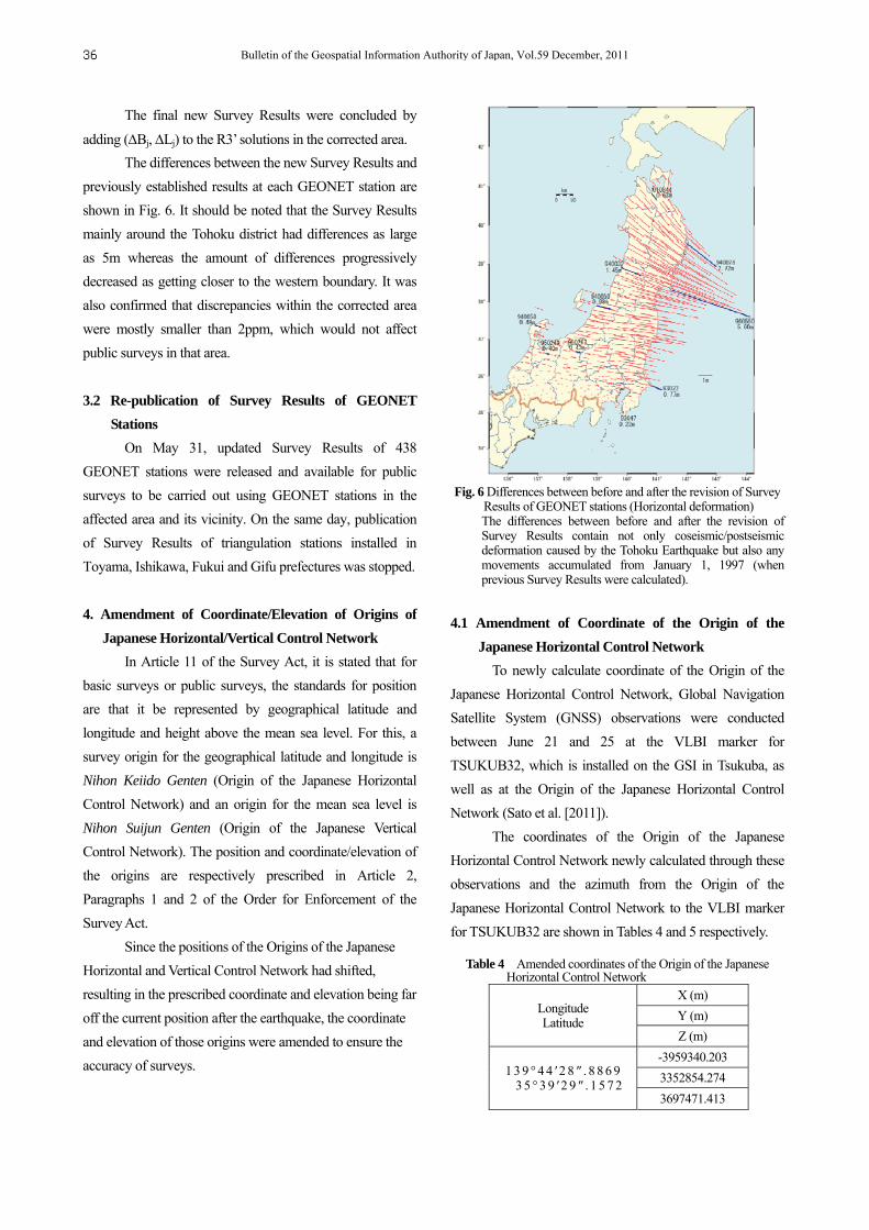
The differences between the new Survey Results and
previously established results at each GEONET station are
shown in Fig. 6. It should be noted that the Survey Results
mainly around the Tohoku district had differences as large
as 5m whereas the amount of differences progressively
decreased as getting closer to the western boundary. It was
also confirmed that discrepancies within the corrected area
were mostly smaller than 2ppm, which would not affect
public surveys in that area.
3.2 Re-publication of Survey Results of GEONET
Stations
On May 31, updated Survey Results of 438
GEONET stations were released and available for public
surveys to be carried out using GEONET stations in the
affected area and its vicinity. On the same day, publication
of Survey Results of triangulation stations installed in
Toyama, Ishikawa, Fukui and Gifu prefectures was stopped.
4. Amendment of Coordinate/Elevation of Origins of
Japanese Horizontal/Vertical Control Network
In Article 11 of the Survey Act, it is stated that for
basic surveys or public surveys, the standards for position
are that it be represented by geographical latitude and
longitude and height above the mean sea level. For this, a
survey origin for the geographical latitude and longitude is
Nihon Keiido Genten (Origin of the Japanese Horizontal
Control Network) and an origin for the mean sea level is
Nihon Suijun Genten (Origin of the Japanese Vertical
Control Network). The position and coordinate/elevation of
the origins are respectively prescribed in Article 2,
Paragraphs 1 and 2 of the Order for Enforcement of the
Survey Act.
Since the positions of the Origins of the Japanese
Horizontal and Vertical Control Network had shifted,
resulting in the prescribed coordinate and elevation being far
off the current position after the earthquake, the coordinate
and elevation of those origins were amended to ensure the
accuracy of surveys.
Fig. 6 Differences between before and after the revision of Survey Results of GEONET stations (Horizontal deformation) The differences between before and after the revision of Survey Results contain not only coseismic/postseismic deformation caused by the Tohoku Earthquake but also any movements accumulated from January 1, 1997 (when previous Survey Results were calculated).
4.1 Amendment of Coordinate of the Origin of the
Japanese Horizontal Control Network
To newly calculate coordinate of the Origin of the
Japanese Horizontal Control Network, Global Navigation
Satellite System (GNSS) observations were conducted
between June 21 and 25 at the VLBI marker for
TSUKUB32, which is installed on the GSI in Tsukuba, as
well as at the Origin of the Japanese Horizontal Control
Network (Sato et al. [2011]).
The coordinates of the Origin of the Japanese
Horizontal Control Network newly calculated through these
observations and the azimuth from the Origin of the
Japanese Horizontal Control Network to the VLBI marker
for TSUKUB32 are shown in Tables 4 and 5 respectively.
Table 4 Amended coordinates of the Origin of the Japanese Horizontal Control Network
Longitude Latitude
X (m)
Y (m)
Z (m)
1 3 9 ° 4 4 ′2 8 ″ . 8 8 6 9 3 5 ° 3 9 ′2 9 ″ . 1 5 7 2
-3959340.203
3352854.274
3697471.413
Bulletin of the Geospatial Information Authority of Japan, Vol.59 December, 201136
Table 5 Azimuth from the Origin of the Japanese Horizontal Control Network to the VLBI marker at GSI, Tsukuba
Azimuth 3 2 ° 2 0 ′4 6 ″ . 2 0 9
4.2 Amendment of Elevation of the Origin of the
Japanese Vertical Control Network
Sea levels recorded at the Aburatsubo tide station
before and after the Tohoku Earthquake showed that no
significant tidal change associated with the earthquake was
observed. Although GPS observations showed that
P-Aburatsubo (GPS observation point located in the
Aburatsubo tide station site) and the GEONET station
"Miura 2" located nearby had sunk by several centimeters
following the March 11 earthquake, the amount of sinkage
tends to decrease with the progress of postseismic
deformations. No significant change in ellipsoidal height
was observed between pre-earthquake (January 2011) GPS
observation results and post-earthquake (July 2011) results
in terms of uncertainty of GPS observations.
Therefore, new elevation of the Origin of the
Japanese Vertical Control Network was calculated through
the following procedures and and then verified by the
procedure.
The leveling results used in this calculation were
taken from the leveling route shown in Fig. 7.
Fig. 7 Leveling route used in calculation of elevation of the Origin of the Japanese Vertical Control Network
When the elevation of the Origin of the Japanese Vertical
Control Network was fixed based on leveling results from
the region between the Aburatsubo tide station and the
Origin of the Japanese Vertical Control Network in January
2011 prior to the earthquake, the height of the reference
point at the Aburatsubo tide station was determined to be
2.4173m.
By fixing the elevation of the reference point at the
Aburatsubo tide station obtained in , the new elevation of
the Origin of the Japanese Vertical Control Network
calculated based on leveling results of July 2011 was
determined to be 24.3904m.
For verification, the elevation of the Origin of the
Japanese Vertical Control Network was calculated based on
the results of leveling between the VLBI marker for
TSKUB32 and the Origin of the Japanese Vertical Control
Network with the result of 24.4007m (Fukuzaki, 2011).
With regard to standard deviation of the network
adjustment of the leveling, since the estimated error of
0.0026m may be contained in the results shown in and
, the newly amended elevation of the Origin of the
Japanese Vertical Control Network should be 24.3900m
after rounding off the ten-thousandth place.
4.3 Amendment of the Order for Enforcement of the
Survey Act
Since the coordinate/elevation of the Origins of the
Japanese Horizontal/Vertical Control Network were
prescribed respectively in Article 2, Paragraphs 1 and 2 of
the Order for Enforcement of the Survey Act, the order
needed to be amended. Also, because Article 11 of the
Survey Act requires Survey Results of control points to be
expressed relative to these origins, the order for enforcement
must first be amended before the Survey Results of control
points can be revised. After being processed through
required procedures, a cabinet decision on the amendment
of the Order for Enforcement of the Survey Act was reached
on October 18, 2011, followed by promulgation and
implementation on October 21, 2011.
5. Revision of Survey Results of Triangulation Stations
To ensure accuracy of the revised Survey Results of
triangulation stations, it is desired that surveys are
Revision of Survey Results of Control Points after the 2011 off the Pacific Coast of Tohoku Earthquake 37
conducted on-site at triangulation stations. However, in
terms of time and cost it is not always practical to conduct
surveys at each and every triangulation station due to the
fact that publication of Survey Results for more than 40,000
triangulation stations was stopped. Since the observed
crustal deformation due to the Tohoku Earthquake was
relatively similar in a wide area, precise geodetic surveys
were to be conducted only at a selected number of
triangulation stations - similar to practices followed after the
Tokachi-oki Earthquake in 2003 (Doi et al. [2005]) - and
triangulation stations not targeted for resurvey were to have
their Survey Results recalculated using correction
parameters. In addition, latitudes and longitudes of
triangulation stations in the affected 20 prefectures
(including Tokyo) for which publication of Survey Results
was stopped were to be revised. Elevations of triangulation
stations in six Tohoku prefectures and Ibaraki also needed to
be revised since significant vertical movements (more than
10cm) immediately after the earthquake and certain vertical
movements due to postseismic crustal activities were
observed throughout the Pacific coast area covering the
Tohoku district and Ibaraki. While conducting triangulation
station resurveys and precise geodetic surveys after the
March 12 earthquake which occurred near the boundary
between Nagano and Niigata prefectures, elevations of that
area were revised as well.
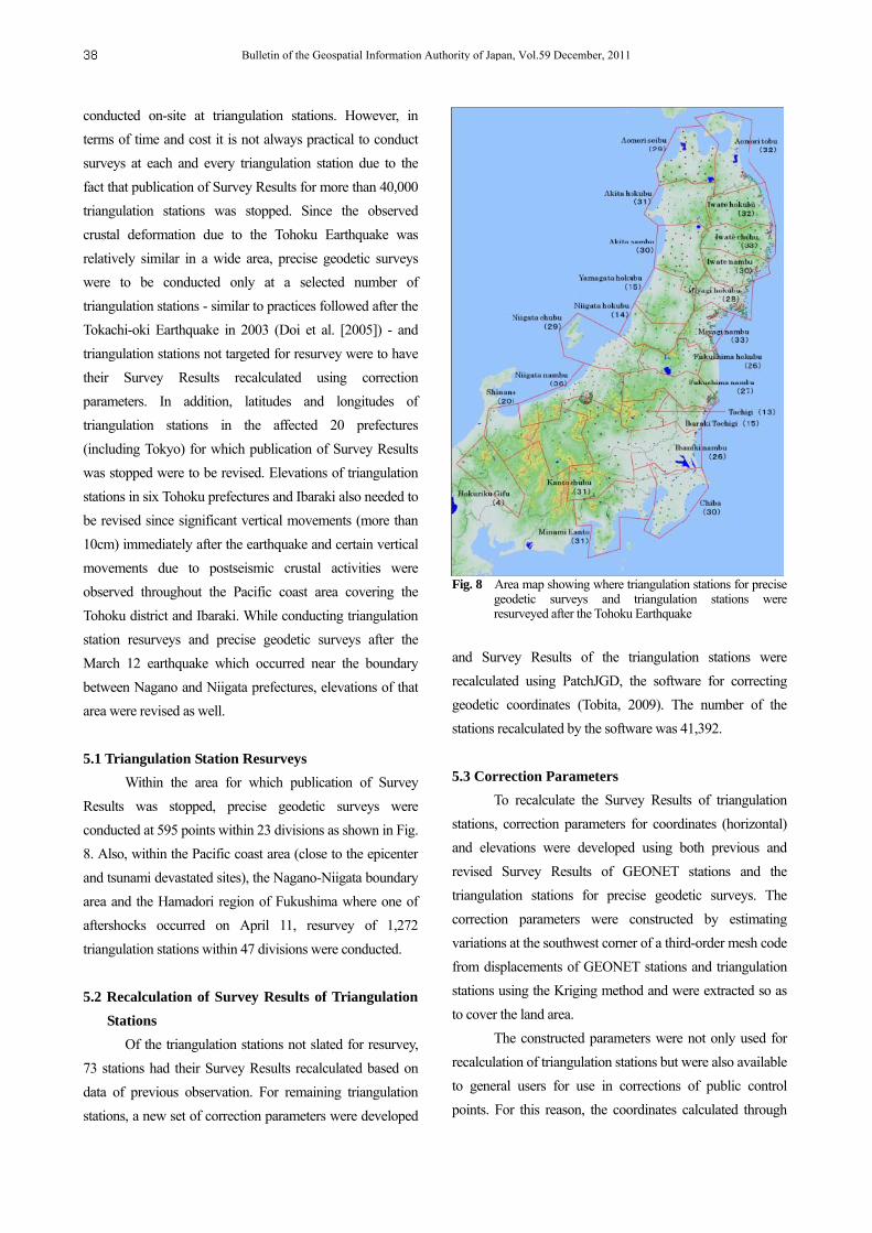
5.1 Triangulation Station Resurveys
Within the area for which publication of Survey
Results was stopped, precise geodetic surveys were
conducted at 595 points within 23 divisions as shown in Fig.
8. Also, within the Pacific coast area (close to the epicenter
and tsunami devastated sites), the Nagano-Niigata boundary
area and the Hamadori region of Fukushima where one of
aftershocks occurred on April 11, resurvey of 1,272
triangulation stations within 47 divisions were conducted.
5.2 Recalculation of Survey Results of Triangulation
Stations
Of the triangulation stations not slated for resurvey,
73 stations had their Survey Results recalculated based on
data of previous observation. For remaining triangulation
stations, a new set of correction parameters were developed
Fig. 8 Area map showing where triangulation stations for precise geodetic surveys and triangulation stations were resurveyed after the Tohoku Earthquake
and Survey Results of the triangulation stations were
recalculated using PatchJGD, the software for correcting
geodetic coordinates (Tobita, 2009). The number of the
stations recalculated by the software was 41,392.
5.3 Correction Parameters
To recalculate the Survey Results of triangulation
stations, correction parameters for coordinates (horizontal)
and elevations were developed using both previous and
revised Survey Results of GEONET stations and the
triangulation stations for precise geodetic surveys. The
correction parameters were constructed by estimating
variations at the southwest corner of a third-order mesh code
from displacements of GEONET stations and triangulation
stations using the Kriging method and were extracted so as
to cover the land area.
The constructed parameters were not only used for
recalculation of triangulation stations but were also available
to general users for use in corrections of public control
points. For this reason, the coordinates calculated through
Bulletin of the Geospatial Information Authority of Japan, Vol.59 December, 201138
the correction parameters were verified (external evaluation)
through comparison with coordinates obtained through
actual surveys.
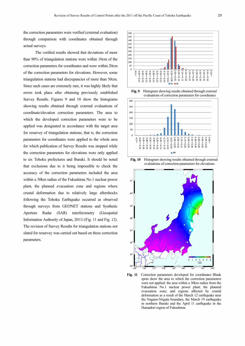
The verified results showed that deviations of more
than 90% of triangulation stations were within 10cm of the
correction parameters for coordinates and were within 20cm
of the correction parameters for elevations. However, some
triangulation stations had discrepancies of more than 50cm.
Since such cases are extremely rare, it was highly likely that
errors took place after obtaining previously established
Survey Results. Figures 9 and 10 show the histograms
showing results obtained through external evaluations of
coordinate/elevation correction parameters. The area to
which the developed correction parameters were to be
applied was designated in accordance with the target area
for resurvey of triangulation stations; that is, the correction
parameters for coordinates were applied to the whole area
for which publication of Survey Results was stopped while
the correction parameters for elevations were only applied
to six Tohoku prefectures and Ibaraki. It should be noted
that exclusions due to it being impossible to check the
accuracy of the correction parameters included the area
within a 30km radius of the Fukushima No.1 nuclear power
plant, the planned evacuation zone and regions where
crustal deformation due to relatively large aftershocks
following the Tohoku Earthquake occurred as observed
through surveys from GEONET stations and Synthetic
Aperture Radar (SAR) interferometry (Geospatial
Information Authority of Japan, 2011) (Fig. 11 and Fig. 12).
The revision of Survey Results for triangulation stations not
slated for resurvey was carried out based on these correction
parameters.
Fig. 9 Histogram showing results obtained through external
evaluations of correction parameters for coordinates
Fig. 10 Histogram showing results obtained through external
evaluations of correction parameters for elevations
Fig. 11 Correction parameters developed for coordinates Blank
spots show the area to which the correction parameters were not applied: the area within a 30km radius from the Fukushima No.1 nuclear power plant; the planned evacuation zone; and regions affected by crustal deformation as a result of the March 12 earthquake near the Nagano-Niigata boundary, the March 19 earthquake in northern Ibaraki and the April 11 earthquake in the Hamadori region of Fukushima.
Revision of Survey Results of Control Points after the 2011 off the Pacific Coast of Tohoku Earthquake 39
Fig. 12 Correction parameters developed for elevations Blank spots show the area to which the correction parameters were not applied: the area within a 30km radius from the Fukushima No.1 nuclear power plant; the planned evacuation zone; and regions affected by crustal deformation as a result of the March 19 earthquake in northern Ibaraki and the April 11 earthquake in the Hamadori region of Fukushima.
6. Revision of Survey Results of Bench Marks
The target accuracy of the correction parameters for
elevations used for the revision of Survey Results of
triangulation stations was 10cm to 20cm and those
parameters cannot be applied in the revision of Survey
Results of bench marks that requires elevation accuracy of
0.1mm to 1mm. Therefore, revision of Survey Results of
bench marks were, in essence, to be done through resurvey,
and network adjustment with multiple reference points was
calculated based on the updated elevation of the Origin of
the Japanese Vertical Control Network and high-precision
3D surveys (leveling) conducted in the Tohoku and Kanto
districts.
The regions where high-precision 3D surveys were
conducted to update the elevation of the Origin of the
Japanese Vertical Control Network as well as the Survey
Results of bench marks are the 24 divisions (3,660km) as
shown in Fig. 13.
Fig. 13 Map of the 24 divisions where high-precision 3D surveys were conducted
When calculating network adjustment, it was
essential to minimize the impact on areas that do not include
resurvey-slated leveling routes so as to ensure a certain
degree of accuracy. To do so, network adjustment had to be
calculated by designating multiple bench marks that were
not affected by the earthquake as reference points.
The reference points were determined, after
discussion, to be the first-order bench mark 5527-2 located
in Ninohe of Iwate as well as the Origin of the Japanese
Vertical Control Network.
Revised Survey Results of bench marks obtained by
network adjustment calculations based on these two
reference points were released on October 31. Fig. 14 shows
the difference between the revised Survey Results and the
Geodetic Coordinates 2000 (vertical).
Hachinohe
Miyako
Kesennuma
Senda
Fukushima
Koriyama
Mito
Hokota
Togane
Chiba Kanagawa
Atsugi
Omiya
Utsunomiya
Nikko
Ojiya
Shirakawa
Kaminoyama
Yuzawa
Taiwa
Ninohe
Kitakami Shiwa
Ichinoseki
Bulletin of the Geospatial Information Authority of Japan, Vol.59 December, 201140
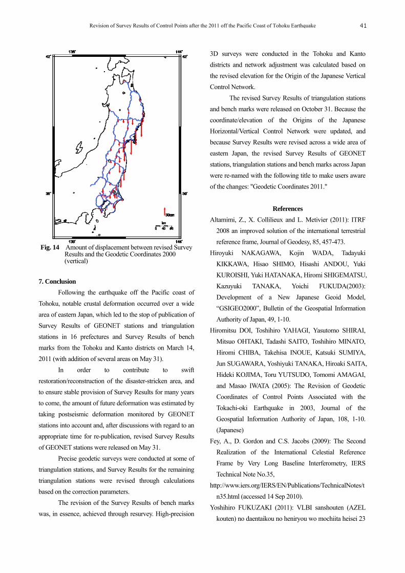
Fig. 14 Amount of displacement between revised Survey Results and the Geodetic Coordinates 2000
(vertical)
7. Conclusion
Following the earthquake off the Pacific coast of
Tohoku, notable crustal deformation occurred over a wide
area of eastern Japan, which led to the stop of publication of
Survey Results of GEONET stations and triangulation
stations in 16 prefectures and Survey Results of bench
marks from the Tohoku and Kanto districts on March 14,
2011 (with addition of several areas on May 31).
In order to contribute to swift
restoration/reconstruction of the disaster-stricken area, and
to ensure stable provision of Survey Results for many years
to come, the amount of future deformation was estimated by
taking postseismic deformation monitored by GEONET
stations into account and, after discussions with regard to an
appropriate time for re-publication, revised Survey Results
of GEONET stations were released on May 31.
Precise geodetic surveys were conducted at some of
triangulation stations, and Survey Results for the remaining
triangulation stations were revised through calculations
based on the correction parameters.
The revision of the Survey Results of bench marks
was, in essence, achieved through resurvey. High-precision
3D surveys were conducted in the Tohoku and Kanto
districts and network adjustment was calculated based on
the revised elevation for the Origin of the Japanese Vertical
Control Network.
The revised Survey Results of triangulation stations
and bench marks were released on October 31. Because the
coordinate/elevation of the Origins of the Japanese
Horizontal/Vertical Control Network were updated, and
because Survey Results were revised across a wide area of
eastern Japan, the revised Survey Results of GEONET
stations, triangulation stations and bench marks across Japan
were re-named with the following title to make users aware
of the changes: "Geodetic Coordinates 2011."
References
Altamimi, Z., X. Collilieux and L. Metivier (2011): ITRF
2008 an improved solution of the international terrestrial
reference frame, Journal of Geodesy, 85, 457-473.
Hiroyuki NAKAGAWA, Kojin WADA, Tadayuki
KIKKAWA, Hisao SHIMO, Hisashi ANDOU, Yuki
KUROISHI, Yuki HATANAKA, Hiromi SHIGEMATSU,
Kazuyuki TANAKA, Yoichi FUKUDA(2003):
Development of a New Japanese Geoid Model,
“GSIGEO2000”, Bulletin of the Geospatial Information
Authority of Japan, 49, 1-10.
Hiromitsu DOI, Toshihiro YAHAGI, Yasutomo SHIRAI,
Mitsuo OHTAKI, Tadashi SAITO, Toshihiro MINATO,
Hiromi CHIBA, Takehisa INOUE, Katsuki SUMIYA,
Jun SUGAWARA, Yoshiyuki TANAKA, Hiroaki SAITA,
Hideki KOJIMA, Toru YUTSUDO, Tomomi AMAGAI,
and Masao IWATA (2005): The Revision of Geodetic
Coordinates of Control Points Associated with the
Tokachi-oki Earthquake in 2003, Journal of the
Geospatial Information Authority of Japan, 108, 1-10.
(Japanese)
Fey, A., D. Gordon and C.S. Jacobs (2009): The Second
Realization of the International Celestial Reference
Frame by Very Long Baseline Interferometry, IERS
Technical Note No.35,
http://www.iers.org/IERS/EN/Publications/TechnicalNotes/t
n35.html (accessed 14 Sep 2010).
Yoshihiro FUKUZAKI (2011): VLBI sanshouten (AZEL
kouten) no daentaikou no heniryou wo mochiita heisei 23
Revision of Survey Results of Control Points after the 2011 off the Pacific Coast of Tohoku Earthquake 41
nen (2011 nen) touhokuchihou taiheiyouoki jisin go no
suijungentensuuchi no suitei,kokudochiriin sokuchibu
heisei 23 nendo gijutsuhoukokusho. (Estimation of the
numeric values of the vertical datum after the 2011 off the
Pacific coast of Tohoku Earthquake based on the change
in ellipsoidal height at the VLBI reference point (AZEL
intersecting point), 2011 Technical Report by Geodetic
Department, Geospatial Information Authority of Japan.)
(Japanese)
Godard Geodetic VLBI Group’s Gemini auxiliary web
pages, http://gemini.gsfc.nasa.gov/solve_save/ usno_final
s .erp (accessed 27 Feb, 2009).
Hisashi SUITO, Takuya NISHIMURA, Shinzaburo
OZAWA, Tomokazu KOBAYASHI, Mikio TOBITA,
Tetsuro IMAKIIRE, Shinichiro HARA, Hiroshi YARAI,
Toshihiro YAHAGI, Hisao KIMURA and Satoshi
KAWAMOTO (2011a): Coseismic Deformation and
Fault Model of the 2011 off the Pacific coast of Tohoku
Earthquake, Based on GEONET, Journal of the
Geospatial Information Authority of Japan, 122, 29-37.
(Japanese)
Hisashi SUITO, Takuya NISHIMURA, Shinzaburo
OZAWA, Mikio TOBITA, Shinichiro HARA, Hiroshi
YARAI, Toshihiro YAHAGI, Hisao KIMURA and
Satoshi KAWAMOTO (2011b): Postseismic Deformation
and Postseismic Slip Model Following the 2011 off the
Pacific coast of Tohoku Earthquake, Based on GEONET,
Journal of the Geospatial Information Authority of Japan,
122, 39-46. (Japanese)
Toshio KAWAHARA (2011): Touhokuchihou taiheiyouoki
jisin ni tomonau chikakuhendouchiiki no jioido heno
eikyoukeisan ni tuite, kokudochiriin sokuchibu heisei 23
nendo gijutsuhoukokusho. (Effect calculation for the
geoid in the area of crustal deformation due to the 2011
off the Pacific coast of Tohoku Earthquake, 2011
Technical Report by Geodetic Department, Geospatial
Information Authority of Japan.) (Japanese)
Geospatial Information Authority of Japan (2011):
Touhokuchihou taiheiyouoki jisin ni tomonau
chikakuhendou wo mentekini haaku - saishuuban wo
sakusei (Understanding crustal deformation caused by the
2011 off the Pacific coast of Tohoku Earthquake through
monitoring of the earth's surface - Final Report),
http://www.gsi.go.jp/uchusokuchi/uchuusokuchi40010.ht
ml (accessed 30 Nov. 2011). (Japanese)
Marone, C. J., C. H. Scholtz and R. Bilham (1991): On the
Mechanics of Earthquake Afterslip, Journal of
Geophysical Research, 96, B5, 8441-8452.
Yuji MIURA, Kenji YOSHIDA, Kyoko KOTANI, Shinobu
KURIHARA and Satoshi KAWAMOTO (2009):
VLBI-GPS Co-location Survey, Journal of the Geospatial
Information Authority of Japan, 119, 71-85. (Japanese)
Niell, A.E (1996): Global mapping functions for the
atmosphere delay at radio wavelengths, Journal of
Geophysical Research, 101, B2, 3227-3246.
Petrov, L., C. Ma (2003): Study of harmonic site positions
determined by very long baseline interferometry, Journal
of Geophysical Research, 108, B4, 2190,
doi:10.1029/2002JB001801.
Yudai SATO, Toshiyuki SASAKI and Satoshi UENO
(2011): Heisei 23 nen (2011 nen) Touhokuchihou
taiheiyouoki jisin ni tomonau nihonkeiidogenten no
atarashii gentensuuchi no sanshutsu , kokudochiriin
sokuchibu heisei 23 nendo gijutsuhoukokusho.
(Calculations of the revised numeric values of the
horizontal datum and vertical datum of Japan after the
2011 off the Pacific coast of Tohoku Earthquake, 2011
Technical Report by Geodetic Department, Geospatial
Information Authority of Japan.) (Japanese)
Mikio TOBITA (2009): PatchJGD, Software for Correcting
Geodetic Coordinates for Coseismic Displacements,
Journal of the Geodetic Society of Japan, 55, 355-367.
(Japanese)
Bulletin of the Geospatial Information Authority of Japan, Vol.59 December, 201142