Embed Size (px)
Citation preview
SCALE 1:195,000
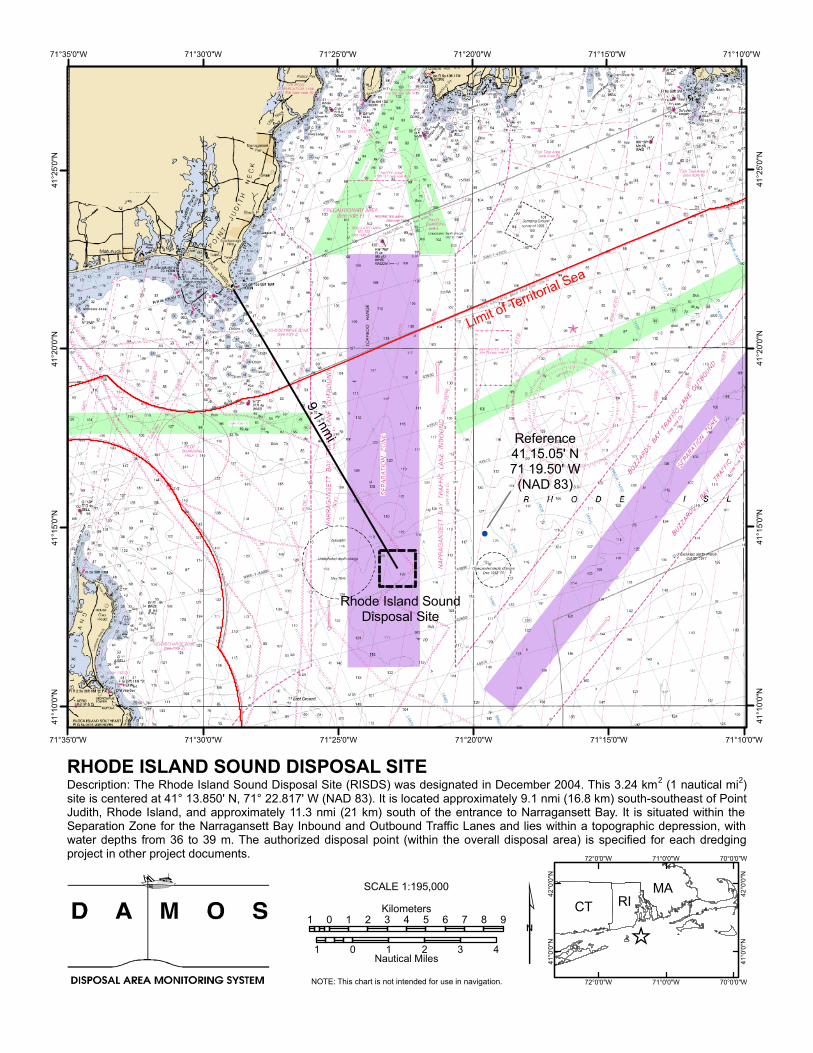
9.1 nmi
71°10'0"W
71°10'0"W
71°15'0"W
71°15'0"W
71°20'0"W
71°20'0"W
71°25'0"W
71°25'0"W
71°30'0"W
71°30'0"W
71°35'0"W
71°35'0"W41
°25'0"
N
41°25
'0"N
41°20
'0"N
41°20
'0"N
41°15
'0"N
41°15
'0"N
41°10
'0"N
41°10
'0"N
Description: The Rhode Island Sound Disposal Site (RISDS) was designated in December 2004. This 3.24 km2 (1 nautical mi2)site is centered at 41° 13.850' N, 71° 22.817' W (NAD 83). It is located approximately 9.1 nmi (16.8 km) south-southeast of PointJudith, Rhode Island, and approximately 11.3 nmi (21 km) south of the entrance to Narragansett Bay. It is situated within theSeparation Zone for the Narragansett Bay Inbound and Outbound Traffic Lanes and lies within a topographic depression, withwater depths from 36 to 39 m. The authorized disposal point (within the overall disposal area) is specified for each dredgingproject in other project documents.
70°0'0"W
70°0'0"W
71°0'0"W
71°0'0"W
72°0'0"W
72°0'0"W
42°0
'0"N
42°0
'0"N
41°0
'0"N
41°0
'0"N
RHODE ISLAND SOUND DISPOSAL SITE
1 0 1 2 3 4 5 6 7 8 9Kilometers
1 0 1 2 3 4Nautical MilesNOTE: This chart is not intended for use in navigation.
Limit of Territorial Sea
Rhode Island SoundDisposal Site
CT RIMA
Reference41 15.05' N71 19.50' W
(NAD 83)

![RHODE ISLAND HISTORY · 66 First Rhode Islander ill Tasmania [July 1949] Fin! Rhode Islander in T asmania 67 Gardner's Journal also rela tes how on Monday, October I, they](https://img.pdfslide.tips/doc/110x75/5d3733c188c99302538c5785/rhode-island-66-first-rhode-islander-ill-tasmania-july-1949-fin-rhode-islander.jpg)