Embed Size (px)
Citation preview
SITE STUDYSHEET
INTEGRATED TOWNSHIP @ CHIKKAJALA, North Bangalore
SIVAKUMAR.KAC09UAR034
DEPT OF ARCHITECTUREADHIYAMAAN COLLEGE OF ENGG
HOSUR
THESIS 2013 - 2014 S I T E & I T S E N V I R O N M E N T S
S I T E & I T S E N V I R O N M E N T – C H I K K A J A L A , N O R T H B A N G A L O R E
S E T T L E M E N T S Male Female Total
Byanahalli 200 178 378Meenakunte 828 606 1434Chokkanahalli 576 518 1094Bettahalasuru 1327 1366 2693Kodigenahalli 1007 952 1959Sonnapanahalli 1605 1423 3028 Hosahalli 638 579 1217Chikkajala 1244 1188 2432 Huttanahalli 1297 1158 2455Maranayakanahalli 169 162 331Doddajala 692 670 1362
Devanahalli 12126 11280 23406Yelahanka 48075 42752 90827Source : Census of India, 2011
• Chikkajala is a place in North Bangalore, India.• It is referred as a Pre-Historic site by ASI (Archeological Survey of India) monument list. • This place has 950 years old Channarayaswamy Temple built by Hoysala King Vishnuvardhana• Coordinates: 13°10'18"N 77°38'3"E
• Companies like Infosys, Goldman Sachs, Philips, Fidelity, Satyam and Star TV have their offices within/near North Bangalore • Current Residential Development: Sobha Althea, Shriram Sunaina, Ramkey One North, Purva Venezia, Godrej Woodsman Estate, Renaissance Prospero, Century Wintersun, Prestige Oasis, RMZ Galleria• Integrated Townships namely Bharatiya City and Ozone Urbana etc.• Office & SEZ Development: Embassy Kirloskar Business Park and Embassy Manyata Business Park• Retail Development: Small format retail stores besides The Esteem Mall, which is the only operational mall on this stretch
I N F R A S T R U C T U R E I N I T I A T I V E S
• Enhanced connectivity has triggered the overall growth of Bangalore city• Proposed 33 Kms Bangalore High-Speed Rail Link (HSRL) connecting Bangalore's city center with Bangalore International Airport (BIA) along National Highway 7• Hebbal - Yelahanka Expressway• 6 lane Bangalore–Mysore Infrastructure Corridor• Outer Ring Road : Signal-Free Flyovers
• Infrastructure Development Drivers: Close vicinity to the Bangalore Airport• Proposed Peripheral Ring Road (PRR) which would connect NH7 with all major roads emanating out of Bangalore • Speed Rail Link between Bangalore CBD to Bangalore Airport• Number of high quality commercial, residential, retail and hospitality developments planned in this region providing impetus to growth of this region
N O R T H B A N G A L O R E
D I S T A N C E I N D I C A T O R
ITC Factory – 4 KmsBengaluru International Airport – 11 KmsDevanahalli – 12 KmsYelahanka Railway Station – 11 KmsHebbal Flyover – 16 KmsM G Road – 20 Kms Source : maps.google.co.in
Doddajala LakeLak
e
Meenakunte
Byanahalli
Chokkanahalli
Bettahalasuru
Sonnapanahalli
Proposed Site
115 Acres
ChikkajalaSri R
evana
Siddeshwara Institute
of Technology
Bettahalasuru
Narayanapura
Shakthi Nagar
Chik
kajal
a Fo
rt
Sri Venkateshwara College of
Engineering
MaranayakanahalliGurukula School
Hosahalli
Huttanahalli
Higher Primary School
Doddajala
Kodigenahalli
Sindhu Cargo Services Private Limited
ITC Factory
Indian Oil
Chikkajala Police Station
Stonehill International School
Sai Vidya Mandir
RS Technical College
Yelahanka Air Force
Station
HunasamaranahalliLake
Bangalore Hyderabad Highway
Yelahanka
Yelahanka Railway Station
Devanahalli
TowardsM G Road
Bengaluru International Airport
Bellary road
Source : http://ces.iisc.ernet.in/energy/wetlands/sarea.html (Indian Institute of Science, IISC – Bangalore)
SITE STUDYSHEET
INTEGRATED TOWNSHIP @ CHIKKAJALA, North Bangalore
SIVAKUMAR.KAC09UAR034
DEPT OF ARCHITECTUREADHIYAMAAN COLLEGE OF ENGG
HOSUR
THESIS 2013 - 2014 S I T E & I T S E N V I R O N M E N T S
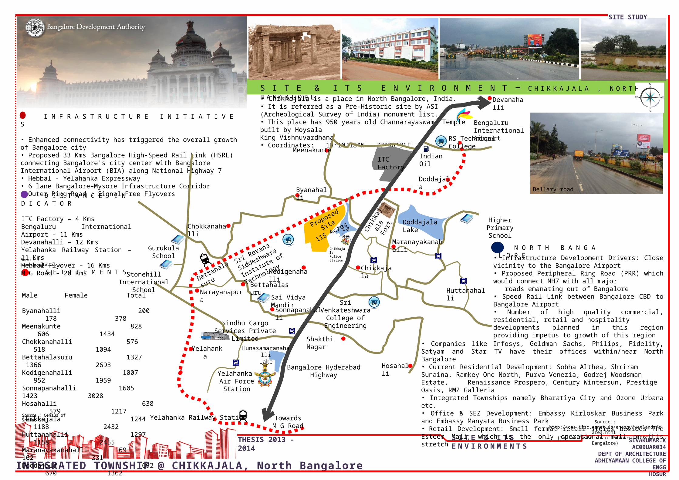
C L I M A T E• Bangalore experiences a tropical savanna climate with distinct wet and dry seasons.• The dry season with clear bright weather is from December to February with summer from March to May, followed by the southwest monsoon season from June to September.• October and November constitute the post-monsoon or retreating monsoon season • The main features of the climate of Bangalore are the agreeable range of, temperatures from the highest maximum of 33o C in April to the lowest minimum of 14oC in January• The two rainy seasons, June to September and October to November, come one after the other but with opposite wind regimes, corresponding to the southwest and northeast monsoons
Dry – Characterised with bright weather from Dec to FebSummer – Characterised by high temperatures, from March – MayMonsoon – South-West monsoon, June – SeptemberPost monsoon - October – November
W A T E R R E S O U R C E S• Bangalore North supports about 98 tanks irrigating about 2,102 ha of land. • These are mostly seasonal and carry water for about six months in a year. • The biggest tank in the Taluk is Hesaraghatta with a catchment area of 490 sq.kms. • The total surface water potential created in the taluk is about 2,330 haG R O U N D W A T E R• Ground water in the district occurs under water table conditions in the weathered mantle of the granitic gneisses & in the joints, crevices and cracks of the basement rock. • Ground water is developed largely by means of open wells. • Open wells as well as bore wells can both yield water between 70 to 90 meters
R A I N F A L LThe mean annual rainfall is 859.6 mm, with three different rainy periods covering eight months of the year. June to September being rainy season receives 54% of the total annual rainfall in the S-W monsoon period and 241-mm during the N-E monsoons (Oct. - Nov.)
W I N DThe surface winds in Bangalore have seasonal character with the Easterly components predominating during one period followed by the Westerly in the other. The high wind speed averages 17 kmph during the westerly winds in the month of July and a minimum of 8-9 kmph during the months of April and October
T O P O G R A P H YThe Bangalore North taluk is more or less a level plateau and lies between 839 to 962 meters above mean sea level.
JAN FEB MAR APR MAY JUN JUL AUG SEP OCT NOV DEC05
10152025303540
JAN FEBMAR APRMAY JUNJUL AUGSEP OCTNOV DEC
T E M P E R A T U R EBangalore records high temperatures during April with daily mean temperatures of 33.4 ( Co and mean daily minimum in the month of December) at 25.7 ( Co, as the coolest month)
JAN FEB MAR APR MAY JUN JUL AUG SEP OCT NOV DEC0
5
10
15
20
25
Series1
H I G H T E M P E R A T U R E
L O W T E M P E R A T U R E
JAN FEB MAR APR MAY JUN JUL AUG SEP OCT NOV DEC0
102030405060708090
Series1
R E L A T I V E H U M I D I T YThe mean monthly relative humidity is the lowest during the month of March at 44% and records highest between the months of June and October at 80 to 85%.
JAN FEB MAR APR MAY JUN JUL AUG SEP OCT NOV DEC0
50
100
150
200
250
300
Series1
Jan Feb Mar Apr May Jun Jul Aug Sep Oct Nov Dec0
0.51
1.52
2.53
3.54
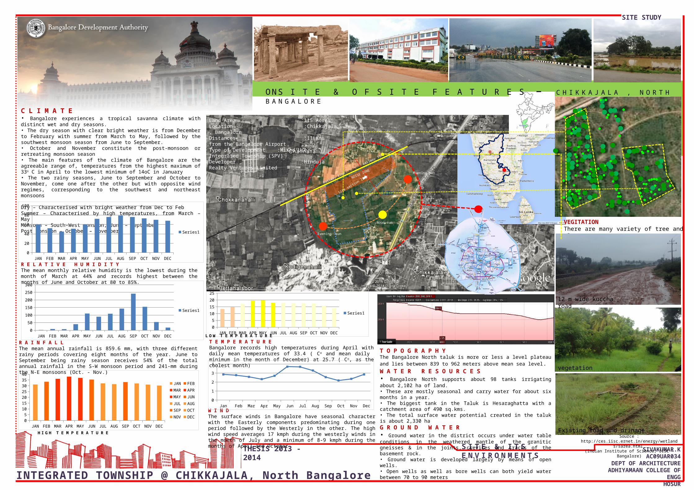
Land Area :115 AcresLocation :Chikkajala, BangaloreDistances :11 Kms from the Bangalore AirportType of Development :Mixed Use Integrated Township (SPV)Developer :Hinduja Realty Ventures Limited
Site section line
VEGITATIONThere are many variety of tree and plants.
O N S I T E & O F S I T E F E A T U R E S – C H I K K A J A L A , N O R T H B A N G A L O R E
vegetation
NOISE ZONE
Railway line
Railway line
Morning sun
Noon sun
Evening sun
Source : http://ces.iisc.ernet.in/energy/wetlands/sarea.html (Indian Institute of Science, IISC – Bangalore)
12 m wide kuccha road
Existing road and drinage
SITE STUDYSHEET
INTEGRATED TOWNSHIP @ CHIKKAJALA, North Bangalore
SIVAKUMAR.KAC09UAR034
DEPT OF ARCHITECTUREADHIYAMAAN COLLEGE OF ENGG
HOSUR
THESIS 2013 - 2014 S I T E & I T S E N V I R O N M E N T S
Railway Line
Existing Entry GateKutcha Road
Prop
osed
Per
iphe
ral R
ing
Road
(PRR
) - B
anga
lore
Hyd
erab
ad H
ighw
ay To
war
ds B
enga
luru
Inte
rnat
iona
l A
irpor
t
Tow
ards
Yel
ahan
ka
12M Wide Kutcha
Road
Chikkajala Lake
PROPOSED SITE115 ACRES
I N S I T E & O N S I T E F E A T U R E S – C H I K K A J A L A , N O R T H B A N G A L O R E
Land Area :115 AcresLocation :Chikkajala, BangaloreDistances :11 Kms from the Bangalore AirportType of Development :Mixed Use Integrated Township (SPV)Developer :Hinduja Realty Ventures Limited
B
BC
C
D
DSECTION BB
SECTION DD
SECTION CC
Source :the sections are taken from google earth
software
12 mKutcha Road
This 12 mKutcha Road is going though the sri raagavendera college and near the villages
A lot of vegetation in and around site some special medicine trees are also available in site
This photo is taken from the
NH towards the hydrabad
highway
The lake is maintain the water table in
around the site
The site both sides are 12 M wide
kuccha road connectivity is there
This is the main entrance of the site and also the near
village and sri ragavendra college main access start
NH main road
The site slopes towards lake side
G R O U N D W A T E R• Ground water in the district occurs under water table conditions in the weathered mantle of the granitic gneisses & in the joints, crevices and cracks of the basement rock. • Ground water is developed largely by means of open wells. • Open wells as well as bore wells can both yield water between 70 to 90 meters
T E M P E R A T U R EBangalore records high temperatures during April with daily mean temperatures of 33.4 ( Co and mean daily minimum in the month of December) at 25.7 ( Co, as the coolest month)
The trees are maintain the place in cool
T O P O G R A P H YThe Bangalore North taluk is more or less a level plateau and lies between 839 to 962 meters above mean sea level.