Embed Size (px)
Citation preview
Document à diffusion restreinte Rapport technique PP/1977/78/4.121.8 TURQUIE
Aide aux Etats membres pour la préservation du patrimoine culturel et naturel et le développement des musées
Sauvegarde et mise en valeur de la péninsule d'Istanbul
Arno Heinz Anthony Meats
N° de série F M R / C C / C H / 7 8 / 1 2 0
Paris, 1978
T U R Q U I E
SAUVEGARDE ET MISE EN VALEUR DE LA
PENINSULE HISTORIQUE
Arno Heinz
Anthony Meats
Rapport établi â l'intention du Gouvernement de la Turquie par l'Organisation des Nations Unies pour l'éducation, la science et la culture (Unesco)
U N S S C 0
Rapport techniaue PP/1977-78/4.181.8 FMR/CC/CH/78/120(Heinz etc) 31 mai 1978
° Unesco 1978 Printed in France
A
I .- SAUVEGARDE ET MISE EN VALEUR DE IA PENINSULE
HISTORIQUE D'ISTANBUL ( Arno Heinz)
Table des Matières
Page
I - SAUVEGARDE ET MESE EN VALEUR DE LA PENINSULE HISTORIQUE D'ISTANBUL (Arno. Heinz)
INTRODUCTION 1
1. La problématique de la Péninsule 2
2. Mesures de sauvegarde et de mise en valeur 7
3. Les principales opérations d'aménagement projetées par la Municipalité d'Istanbul : 17
- Sauvegarde des quartiers résidentiels historiques 17
- Sauvegarde des zones monumentales d'importance internationale 18
- Mise en valeur des zones d'environnement des monuments historiques importants 19
4. Conclusion 20
ILLUSTRATIONS :
1. Istanbul - Péninsule historique - sites historiques 21
2. Istanbul - Topographie 22
3. Istanbul - Espaces urbains romains 23
4. Istanbul - Morphologie / Typologie 24
5. Istanbul - Zones homogènes 25
6. Istanbul - Projets de mise en valeur 26
7. Istanbul - Tourisme 27
II - THE CONSERVATION OP ISTANBUL'S HISTORIC PENINSULA (Anthony Meats)
INTRODUCTION 30
1. The historic peninsula 32
2. The historical city today 33
3. Administrative responsibilities 34
4. Master Plan proposals 36
5. The current position 37
6. A conservation policy 39
- Broad proposals for the historic peninsula 40
- Historic areas for detailed study 41
7. Conclusions 42
- 1 -
INTRODUCTION
En compagnie de Anthony MEATS, nous avons effectué deux séjours à Istanbul, Le premier en Juillet 1977, le second en Janvier 1978. Ce rapport exprime notre accord sur les problèmes de Sauvegarde et de Mise en Valeur de la péninsule historique.
Nous avons rencontré un grand nombre de personnalités de la Municipalité, du Ministère du Tourisme et de l'Université Technique qui nous ont apporté une aide précieuse dans notre travail. Nous avons pu profiter également de la documentation de l'Institut Allemand de l'Archéologie. Nous tenons à remercier, en particulier, Monsieur Turgut CANSEVER Directeur du Bureau de Sauvegarde à la Municipalité, qui est, à notre avis, le principal promoteur de la Mise en Valeur d'Istanbul.
Le changement de gouvernement et l'élection d'un nouveau maire entre nos deux visites ont modifié nos premiers diagnostics : les problèmes de planification dûs aux absences de coordination entre autorités gouvernementales et municipales paraissent pouvoir être résolus dans un avenir proche. Les programmes politiques du nouveau gouvernement prévoient également un renforcement des pouvoirs communaux. Cela pourra permettre à la Municipalité d'Istanbul d'accéder à la réalisation des projets urbains indispensables.
Lors de notre deuxième visite, nous avons pu constater la progression de la dégradation urbaine : c'est surtout la destruction des maisons en bois qui atteint un niveau critique.
La courte durée de nos séjours et l'insuffisance des documents ne nous a pas permis d'approfondir notre diagnostic ni de détailler nos suggestions.
- 2 -
1. LA PROBLEMATIQUE DE LA PENINSULE
Le site historique
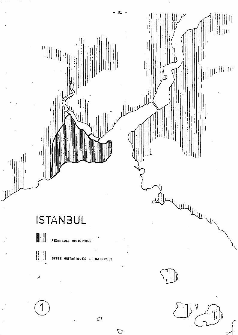
Les sites méritant une protection du patrimoine culturel ou naturel dépassent de loin les 1.000 Ha de la péninsule. Parmi les plus importants : Eyûp, lieu de pèlerinage (on y vénère le tombeau de Eyoub, un des disciples du Prophète), Uskûdar (l'ancienne Chrysopolis, puis Skutari), le faubourg, asiatique d'Istambul et son cimetière qui est parmi les plus grands du monde islamique, Beyoglu, l'ancienne Galata des colons génois et vénitiens. (Cf. plan n° 1) /
Perception de la Ville
Le romantisme du XIX ème siècle a inventé l'image d'une ville "des Mille et Une Nuits" (dessins de Miss Pardoe, poèmes de Pierre Loti), image qui est généralement aussi loin de la réalité que celui de nombreux visiteurs ne voyant que déclin et misère.
Pendant ces dernière années, les couches sociales plus aisées se sont .installées de plus en plus loin de la péninsule, dans de nouveaux quartiers dont l'urbanisme découle de la spéculation foncière. (Le pont sur le Bosphore a pu être amorti ainsi en un temps-record). Par cette population, l'ancienne ville n'est perçue qu'en tant que silhouette lointaine, l'architecture ottomane est perçue comme un anachronisme embarassant.
Les nouveaux habitants venus des campagnes déshéritées se sont installés surtout dans les banlieues des "gecekondu" voyant dans la péninsule avant tout un lieu de travail et un centre commercial populaire.
Pour ces populations encore attachées aux traditions de l'Islam nombre de monuments historiques gardent une signification importante.
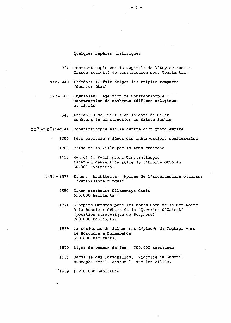
Quelques repères historiques
324 Constantinople est la capitale de l'Empire romain Grande activité de construction sous Constantin.
vers 440 Théodose II fait ériger les triples remparts• (dernier état)
527-565 Ju.stinien. Age d'or de Constantinople Construction de nombreux édifices religieux et civils
548 Anthémius de Tralles et Isidore de Milet achèvent la construction de Sainte Sophie
xesiècles Constantinople est le centre d'un grand empire
1097 1ère croisade : début des interventions occidentales
1203 Prise de la Ville par la 4ème croisade
1453 Mehmet-II Fatih prend Constantinople Istanbul devient capitale de l'Empire Ottoman 50.000 habitants.
1491 - 1578 Sinan> Architecte. Apogée de l'architecture ottomane "Renaissance turque"
1550 Sinan construit Sûlemaniye Camii 550.000 habitants !
1774 L'Empire Ottoman perd les côtes Nord de la Mer Noire à la Russie : débuts de la "Question d'Orient" (position stratégique du Bosphore) 700.000 habitants.
1839 La résidence du Sultan est déplacée de Topkapi vers le Bosphore à Dolmabahce 650.000 habitants.
1870 Ligne de chemin de fer- 700.000 habitants
1915 Bataille des Dardanelles. Victoire du Général Mustapha Kemal (Atatûrk) sur les Alliés.
"1919 1.200.000 habitants
- 4 -
1920-1923 Guerre de l'Indépendance turque
1923 . Proclamation de la République Turque. Désormais Ankara est capitale. Importantes réformes
1927 700.000 habitants à Istanbul
1938 Mort d'Atatürk
1954 La Turquie adhère à l'O.T.A.N.
1960 L'armée prend le pouvoir
1977 La population d'Istanbul est évaluée à 4,5 millions dont 650.000 sur la péninsule historique.
Continuité et développement urbain
Ce n'est pas la première fois dans sa longue histoire qu'Istanbul n'est pas capitale, (par contre, elle a toujours été Centre Commercial) . Ce n'est pas la première fois non plus qu'Istanbul donne l'image hétérogène du quartier urbain fortement constitué au bidonville spontané : les habitants d'Aksaray que Mehmet II a amenés dans sa capitale vide ont dû construire des maisons ressemblant beaucoup aux "gecekondu" d'aujourd'hui....
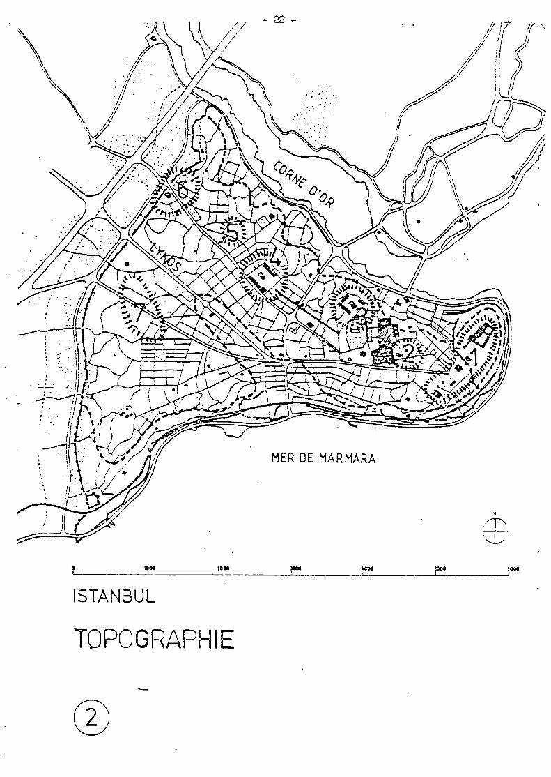
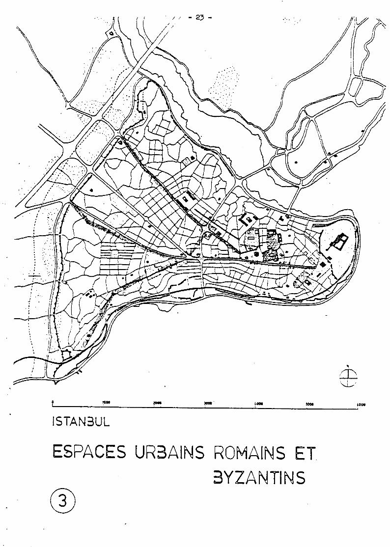
Pourtant, pendant tous ces temps, Istanbul a réussi à préserver une certaine continuité : un équilibre entre ancien et nouveau. C'est ainsi qu'après la prise de Constantinople, non seulement Sainte Sophie fut sauvegardée tout en acquérant une nouvelle signification. Les Ottomans gardent aussi les axes routiers romains, en remplaçant les vides des fora par les pleins des mosquées et des kùlilliés qui deviennent les éléments ordonnateurs principaux : l'image "verticale" de la Ville ottomane (couronnement des 7 collines par des mosquées), remplace le concept "horizontal" des romains. (Cf. plans n° 2 et 3)
Splendeurs et formes monumentales n'ont été réservées qu'aux édifices sacrés, tandis que les types d'habitat étaient modestes, construits en bois et sans grand nombre de variantes individuelles. La morphologie des quartiers résidentiels ottomans reflète une société basée sur l'Islam. L'absence des problèmes de densité a permis de donner une place prépondérante aux jardins, à l'image de la conception du paradis décrit par le Coran.
5 -
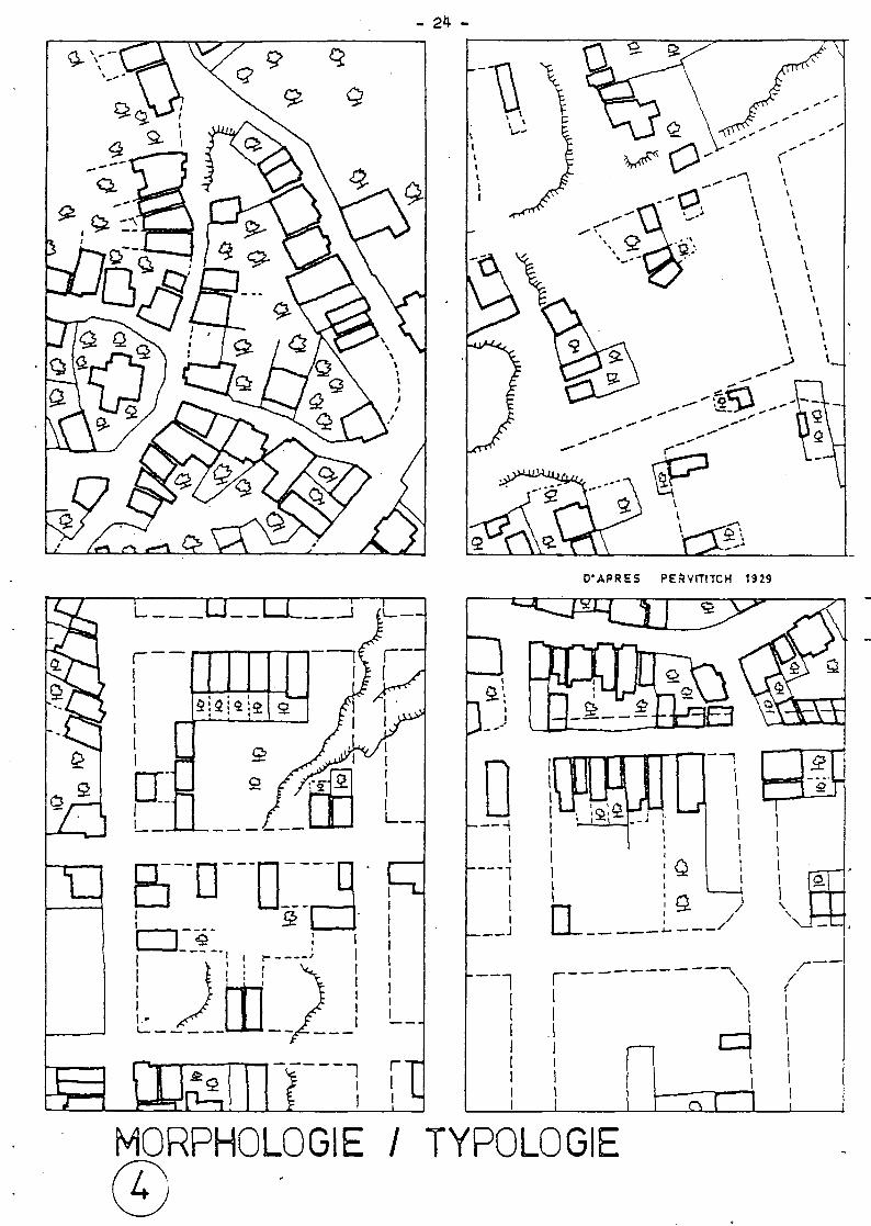
La substitution successive des rapports entre morphologie et typologie à travers l'Histoire, s'est pratiquée (et se pratique encore aujourd'hui) selon les cas-types que l'on peut facilement repérer en parcourant la ville. D'autres sources de lecture : les anciens plans de la Ville. Exemple : les plans d'Assurances (Cf. ill. N° 4 : Passage du tissu urbain traditionnel à un tissu influencé par les modèles occidentaux : la restructuration des quartiers incendiés prévoit un réseau routier basé sur une trame régulière. Elargissements. Percements de voies. De nouveaux types de maisons remplacent les types traditionnels).
Aujourd'hui, cette longue continuité de la structure d'Istah_bul à travers l'Histoire est en danger : manque de contrôle par les Pouvoirs Publics, la ville tend à n'être, de plus en plus, qu'une simple "aire fonctionnelle économique", et de moins en moins, un "milieu de vie". Ceci dans une mesure et à une rapidité qui sont à l'image de l'économie nationale : une croissance industrielle enfiévrée mais mal canalisée dans une planification.
Politique urbaine et actions d'aménagement de l'époque moderne
Depuis 1870, l'ordre traditionnel de la ville islamique a été perturbé par l'intrusion des valeurs du monde industrialisé : la ligne des chemins de fer a brisé les remparts qui sont parmi les plus importants du monde), la gare de Sirkecci a créé une nouvelle centralita, la Corne d'Or a été transformée en zone industrielle boulversant ainsi l'équilibre des fonctions urbaines qui s'y sont perpétuées depuis l'époque byzantine (aujourd'hui les riches demeures en pierre des grandes dynasties commerçantes d'origines grecque , arménienne ou juive, se trouvent transformées en entrepots engloutis par les chantiers navals).
Le transfert du siège gouvernemental à Ankara en 1923 a laissé la ville sans pouvoirs publics suffisants pour faire face aux nécessités de planification.
Henri PROST fut l'auteur du premier Plan Directeur en 1937. Celui)ci ne sera appliqué qu'en partie mais aura participé à la sauvegarde du patrimoine culturel (Topkapi, les remparts) Les études suivantes pendant les années 1940 (P. BONATZ) ne sont pas réalisées.
- 6 -
Le développement industriel pendant les années 1950 a accéléré les études (H. HOGGJ dont la réalisation sera limitée surtout au percement des axes routiers. Les intersections de ceux-ci ont été aménagées dans les années 1960 d'après des modèles d'autoroutes suburbaines (carrefour de Valide Camii).
Les années 1970 n'ont pas vu jusqu'à ce jour les efforts nécessaires pour rattraper le retard immense en planification urbaine.
En 1975, le maintien d'une politique de forte concentration urbaine a été confirmé par l'Agence Gouvernementale du Plan-Directeur (Master Plan Bureau, assisté par Colin Buchanan & Partners) : des 4,5 millions actuels, la population devra croître à 7 millions en 1990.
En même temps, la Municipalité opte pour un plan de décentralisation et souhaite réduire la population de la péninsule de 650.000 habitants à 300.000.
Responsabilités administratives
L'insuffisance de coordination entre les différentes administrations concernées par la planification urbaine ouvre la voie à une dégradation de la qualité urbaine de plus en plus grave. Le pouvoir de la Commune est limité et nombre d'éléments urbains échappent ainsi au contrôle municipal.
Le nouveau gouverneraient Ecevit et M. Kotil, le nouveau maire d'Istanbul, affirment leur volonté de procéder à des réformes importantes dans les domaines de l'urbanisme et du planning régional.
- 7 -
2. MESURES DE SAUVEGARDE ET DE MISE EN VALEUR
Documentation
Le bureau d'étude de la Municipalité devra assurer la coordination de tous les relevés, inventaires, documentations (actuellement dispersés) afin de constituer des archives pouvant jouer lé rôle d'un véritable outil de travail.
Travaux de restauration, protection technique
Les grandes mosquées sont généralement bien entretenues par le service des WaJcoufs (Fondations religieuses) . Par contre la plupart des autres monuments souffrent du manque d'entretien, beaucoup ayant été loués ou vendus à des particuliers : monuments isolés (hans, medreses, hammans, turbes, fontaines, citernes ...) monuments faisant parti des kûlilliés (complexes de bâtiments que forment la mosquée turque et les édifices d'utilité publique attenants).
Sauvegarde active
La restauration des monuments historiques devra être accompagnée d'une réutilisation adaptée de l'espace historique, sa potentialité, sa signification culturelle. On devra donner à ces édifices des activités nouvelles correspondant aux besoins actuels et à ceux de l'avenir : activités culturelles surtout, mais aussi sociales et touristiques.
Protection juridique, législation
La démolition systématique de l'habitat traditionnel et l'activité anarchique de la construction témoignent de l'inefficacité du système de sauvegarde actuel. Pourtant la "Loi sur les Oeuvres Antiques n° 1710" (adoptée en 1973) constitue une base valable (quoique très générale) pour la protection •
- 8 -
Mais les règlements d'urbanisme et d'architecture sont souvent inadéquats aux quartiers anciens d'Istanbul. Exemple : les prescriptions d'alignement et d'élargissement des voies suivant les modèles hygiénistes de l'urbanisme occidental des débuts du siècle.
Le perfectionnement du cadre juridique devra également rendre au permis de construire son rôle d'instrument de contrôle. Celui-ci s'avère actuellement inefficace pour une triple raison :
- inadaptation des servitudes (dont découlent des dérogations systématiques)
- insuffisance des servitudes d'affectation (qui devront être basées sur des Plans d'Occupations des Sols différenciés)
- insuffisance de contrôle (inspection des chantiers).
Servitudes, classement
Le but d'un système de classement devra être une protection des monuments sans trop alourdir la participation de l'Etat. Les servitudes devront être de caractères différents suivant le type de monument et de son importance.
La protection de l'habitat traditionnel devra laisser aux propriétaires une assez grande liberté d'action. Le contraire risque de provoquer une accélération de la démolition.
La Municipalité devra fournir une assistance technique concernant les problèmes de l'amélioration de lhabitat. Un cahier des charges sera à élaborer par les architectes municipaux.
Il est rappelé que les procédures juridiques préservent les monuments de démolition et d'altérations seulement si elles sont suivies d'un contrôle efficace. Mais c'est avant tout une politique de sauvegarde active (et non seulement passive) qui pourra arrêter la dégradation générale.
Protection de la silhouette.
Les efforts du Haut Comité des Monuments et Sites Historiques (Ministère des Affaires Culturelles) ont permis de sauvegarder la silhouette de la péninsule assurant ainsi aux grandes mosquées leur rôle d'éléments constituants de la forme urbaine.
- 9 -
Plan de sauvegarde de la péninsule
Partie intégrante du Plan d'Aménagement du Grand Istanbul, ce plan devra encadrer tous les projets de mise en valeur isolés. Différentes zones de sauvegarde seront à délimiter avec leurs servitudes particulières.
Secteurs de sauvegarde
Le tissu urbain de la péninsule est d'origine historique variée et de qualité inégale : il serait absurde de vouloir appliquer toutes les mesures de protection uniformément sur les 1.000 Ha de la péninsule. De l'autre côté, il est impossible de ne pas tenir compte de l'entité du site et de se limiter uniquement à des. projets d'aménagement isolés.
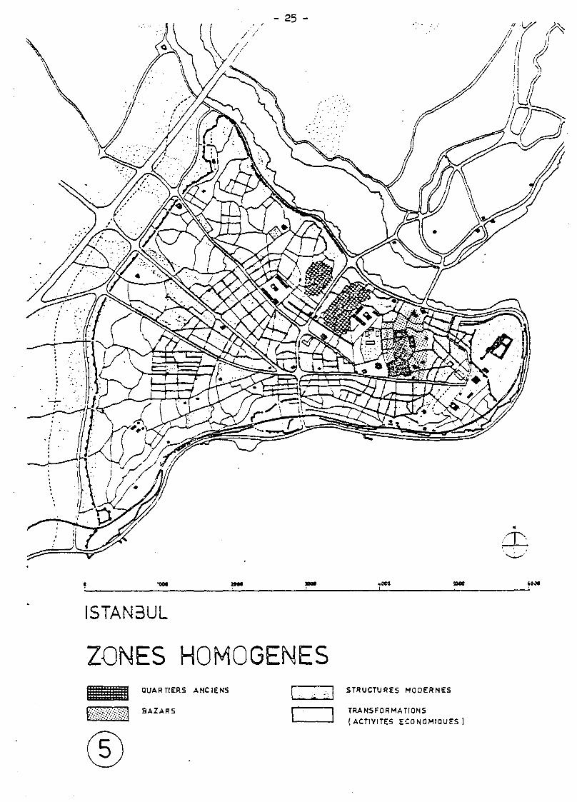
Les mesures de sauvegarde seront plus ou moins strictes suivant les caractéristiques des zones : intérêt historique et architectural, impact urbain, homogénéité. (Cf. plan n° 5) Toutefois, les mesures de sauvegarde ne devront pas bloquer les modifications nécessaires (conditions d'habitat) ni les fonctions économiques (commerces des 3azars).
Habitat et équipements
La qualité de l'habitat de la péninsule (650.000 habitants) est inégale, ne correspondant pas systématiquement à l'âge de bâti. Les déficiences communes sont la surdensification, l'insuffisance et la vétusté des réseaux de distribution et d'assainissement, l'insuffisance d'équipements sociaux et culturels (utilisation alternative des écoles jusqu'à 4 fois par jour), les nuisances dues à l'extension incontrôlée des zones industrielles.
L'habitat le plus ancien est presqu'entièrement détruit. Seulement deux zones restreintes subsistent (maisons en bois dont l'origine dépasse rarement 100 ans) : Sûlemaniye et Zeyrek.
Réhabilitation et assainissement
La réalité économique actuelle interdit toute opération radicale de rénovation, c'est à dire démolition massive suivie de reconstruction. De toute manière la limitation de construire en hauteur et l'actuelle densité extrêmement élevée ne permettraient pas une plus grande rentabilisation des sols, tandis qu'une reconstruction à faible densité entraînerait des prix incompatibles à la solvabilité de la population actuelle.
- 10 -
Un relogement massif des couches défavorisées dans de nouveaux lotissements en banlieue ne peut être envisagé comme solution réaliste. L'accessibilité des nouvelles constructions restera limitée : même des"opérations tiroirs", des systèmes d'industrialisation de la construction ou des formules d'habitat évolutif (autoconstruction) ne permettront pas toujours de réaliser un équilibre financier.
La dernière estimation prévoit un besoin annuel de 50 000 logements à Istanbul dont les prévisions les plus optimistes n'espèrent qu'une production de 30 000.
La pénurie actuelle en logements d'une part et la faible solvabilité générale d'autre part, ne permettent pas d'envisager des opérations de relogement à grande échelle. L'habitat ancien de la péninsule (comme celui de Beyoglu) devra jouer encore longtemps le rôle d'habitat social.
L'effort devra porter sur l'amélioration des conditions d'habitat, sur l'entretien systématique du parc immobilier existant. La situation actuelle de dégradation de ce parc immobilier constitue non seulement une perte pour l'économie nationale, mais aussi un grave danger pour les monuments historiques qui se trouvent Imbriqués dans les quartiers résidentiels.
Politique de réhabilitation de l'habitat
Les expériences européennes pourront guider la Turquie à préparer les réformes propres à améliorer la satisfaction des besoins en matière d'habitat, sans pour autant aller jusqu'à les copier : la situation particulière culturelle, sociale et économique de la Turquie demande une adaptation des expériences de réhabilitation à la réalité du pays.
Les principales options devront être :
- contrôler la transformation urbaine au profit d'une réduction des inégalités sociales
- adapter les opérations d'aménagement aux besoins à satisfaire, au lieu d'appliquer des procédures rigides
- adapter les opérations d'aménagement aux possibilités financières de la Commune et de l'Etat
- simplifier les procédures de la mise en oeuvre.
- créer une coopération des administrations concernées (la Commune doit être en mesure d'assurer la responsabilité principale).
- 11 -
Méthodologie, la typologie opérationnelle
Les expériences internationales montrent que le choix de la méthode est capital pour la réussite des opérations.
Les analyses sont souvent trop partielles et superficielles, inutilement laborieuses et généralement inspirées d'une conception universaliste et fonctionnaliste de l'architecture. Les méthodes appliquées à la restauration des monuments importants, elles aussi, sont inadéquates aux problèmes de l'habitat ancien.
Par contre, la typologie, classement de l'habitat par type de conception et d'occupation, permet de dégager une approche rationnelle tant au niveau de l'élaboration du projet et du choix des techniques adaptées que de la notion de coût des travaux . La méthode de la typologie agit par croisement de données y incluant des critères historiques et urbains.
Croissance urbaine
La planification de l'habitat au niveau de l'agglomération d'Istambul en regard du problème de la croissance urbaine est la condition préalable de l'impact à long terme de toutes les actions de mise en valeur de la péninsule. La limitation de la croissance par la mise en place d'une politique freinant l'exode rural permettra à la ville de retrouver un équilibre propice aux mesures d'aménagement.
Les fonctions économiques de la péninsule
Certains quartiers (les Bazars,Sirkeci) jouent un rôle économique d'une importance qui dépasse la péninsule. Tout plan de sauvegarde devra en tenir compte.
Une stratégie économique d'ensemble devra soulever des problèmes complexes tels que l'interdépendance des activités, la protection de la profession artisanale, la politique fiscale, l'approvisionnement en matières premières, etc..
- 12 -
Les activités artisanales et industrielles
Le passage d'une production artisanale à une production industrielle dans différentes branches• met en danger la sauvegarde des monuments historiques et la morphologie traditionnelle. Les nouvelles fonctions, leurs nuisances, le trafic de poids-lourds qu'elles entraînent sont incompatibles avec les structures urbaines traditionnelles.
Cette incompatibilité fait continuellement baisser la rentabilité de certaines branches d'industrie (les fabricants de chaussures estiment que le coût de leurs produits baisserait de 40% s'ils s'installaient dans les zones industrielles hors de la péninsule, qu'ils réclament à la Municipalité).
Le transfert des activités industrielles importantes hors de la péninsule constitue donc non seulement une opération de sauvegarde du patrimoine culturel mais surtout une nécessité économique.
Le développement de l'artisanat, par contre, est à encourager dans la mesure où il ne nuit pas aux structures spatiales historiques. Il pourra occuper une partie des surfaces libérées par l'industrie. Des activités artisanales susceptibles d'être orientées vers une demande touristique pourront augmenter ainsi leur rentabilité.
D'autre branches artisanales, témoins du passé et des civilisations d'Istanbul, sont à encourager puisqu'elles contribuent à maintenir un label de haute qualité. (Ceci est également valable pour certains commerces de la péninsule).
Les activités industrielles sur les côtes
Les activités industrielles situées sur la Corne d'Or, elles aussi, souffrent de la pénurie spatiale empêchant tout développement vers une meilleure rentabilité. En même temps, ces activités causent des pollutions et nuisances importantes contribuant à une dégradation rapide des quartiers adjacents.
La création d'un port moderne à l'Est d'Istanbul et le transfert des Halles des fruits et légumes déchargera le centre ville. Les surfaces ainsi libérées pourront servir à des aménagements destinés de préférence aux loisirs des habitants et des touristes. Des activités restreintes telles que des petits ports de pêche serviront de pôle d'animation.
- I? -
Les activités commerciales
Le besoin en surfaces des activités commerciales a moins augmenté que celui des activités industrielles. Exemple : 100% d'augmentation des surfaces commerciales du quartier Kücük Aya Sofia entre 1965 et 1975, contre 50% des surfaces commerciales.
Les activités commerciales contemporaines, a 1'encontre des activités industrielles, sont généralement compatibles avec la sauvegarde de l'espace économique historique. Leur développement est à encourager sous condition d'une participation à l'entretien des lieux historiques qu'elles occupent. L'environnement historique des Bazars (des Bedestans, des Hans) est à considérer comme un élément important de l'image commerciale.
Le tourisme, sa potentialité
Le tourisme est une des activités économiques les plus aptes à se développer sur la péninsule d'Istanbul. Actuellement sous exploitée, sa potentialité pourra être mieux utilisée par une triple action :
- la mise en place des équipements touristiques
- la mise en valeur des lieux de visite (monuments historiques et leur environnement)
- la création de nouvelles attractions.
Equipements touristiques
Grâce à son site extraordinaire et à sa richesse en monuments historiques de plusieurs époques et cultures, Istanbul pourra développer un tourisme urbain et culturel très important - même en liaison avec un tourisme balnéaire situé sur les côtes de la Mer de Marmara et de la Mer Noire.
Les besoins actuels en matière d'hébergement touristique restent insatisfaits, en dépit des efforts récents de construction d'hôtels : le nombre d'hôtels touristiques de catégorie moyenne (et celui des hôtels pour jeunes) est nettement insuffisant.
L'insertion des hôtels touristiques dans le tissu urbain ancien et la reconversion de monuments historiques (projet d'aménagement du Vezir Han, Ministère du Tourisme) devront être guidées par trois préoccupations :
- 14 -
- Eviter une incompatibilité entre la signification culturelle des lieux et l'animation touristique.
- Tenir compte des besoins de confort et de repos des touristes (problèmes du bruit, d'odeurs, etc.. de l'environnement)
- Choisir la catégorie d'hôtels en fonction de la potentialité spatiale des lieux historiques, en fonction de l'environnement et des coûts prévisibles nécessaires à l'aménagement.
La construction de restaurants pourra être encouragée en proximité des monuments historiques et sur les côtes de la Mer de Marmara (actuellement, il n'y a qu'un seul restaurant sur la péninsule qui profite à la fois des monuments historiques et d'une vue panoramique).
Lieux de visite, circuits touristiques
La base indispensable du développement touristique sera la mise en valeur des monuments historiques et de leurs environnements. La plupart de ceux-ci ne se présentent guère comme des "joyaux culturels". Même l'environnement de Topkapi Sarayi, pourtant vitrine publicitaire d'Istanbul, ressemble plutôt à un terrain vague d'une quelconque banlieue : là où la signification du site nécessite l'aménagement d'un parc archéologique d'importance internationale, il y a terrains abandonnés, baraquements militaires, clôtures en barbelés, dépôts d'ordures, stocks industriels, ...
La mise en valeur des monuments historiques pourra, non seulement augmenter l'attraction de ceux actuellement visités, mais créer aussi d'autres nouveaux lieux de visites "sensationnels" qui font actuellement défaut.
Nous proposons quatre actions :
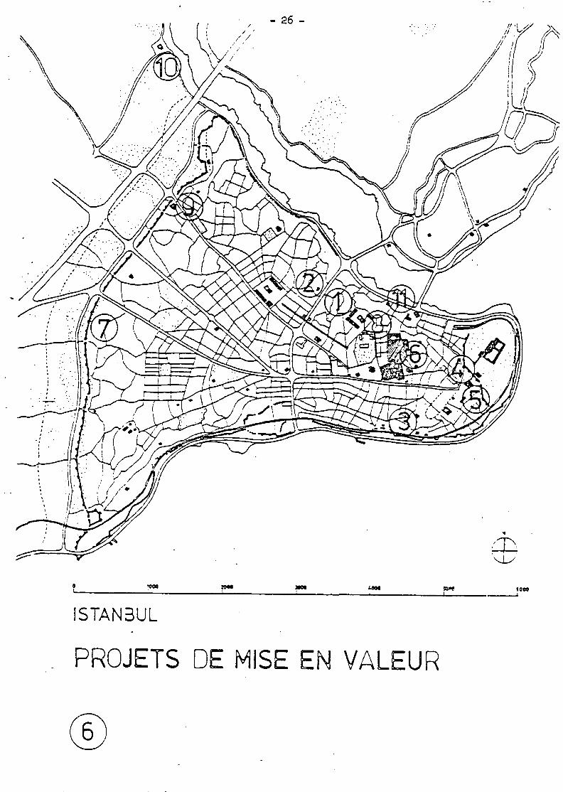
- mise en valeur des monuments historiques et de leurs environnements (Cf. : Projets de la Municipalité - plan n° 6) .
- organisation de nouveaux circuits touristiques : combinaisons des circuits à terre (piétons, bus, minibus) et des circuits en mer (bateau-bus) (Cf. : plan n° 7 )
- fouilles archéologiques internationales (Topkapi, Palais de Constantin,...) Visites touristiques sur des passerelles installées temporairement (Exemple: passerelle de visiteurs du chantier des Halles à PARIS).
- 15 -
- Création de lieux d'exposition et de spectacles (Yedikûle, remparts, Bazar, maisons en bois, ...)
Réseau routier, espaces publics, moyens de transport
L'aménagement indispensable du réseau routier devra aller de pair avec une amélioration de l'adduction d'eau et du réseau des égouts. Ces mesures seront la condition préalable pour le développement d'équipements touristiques sur la péninsule et notamment le long-des côtes.
La circulation automobile pourra être mieux maitrisée grâce à une politique plus rigoureuse de stationnement et au développement des transports publics. Celui-ci devra se baser sur les infrastructures existantes (ligne de chemin de fer), les habitudes locales (taxis collectifs : dolmus), les solutions économiques (tramways sur les grands axes routiers).
Les fonctions économiques importantes de la péninsule interdisent la suppression totale de la circulation automobile de certains secteurs. Seulement la restructuration progressive des activités économiques permettra de créer de vastes zones piétonnières, toutefois dotées d'un système de voies de desserte et d'aires de stationnement.
Le développement du tourisme de masses entraînera un besoin accru des aires de staionnement en proximité des monuments historiques. Leur traitement pourra créer de nouveaux lieux d'animation sans pour autant gêner la signification culturelle des monuments historiques. La construction de parkings souterrains n'est que très rarement justifiable du point de vue économique. Aussi nous proposons de choisir plutôt des solutions à niveau de rue, aménagées de telle manière que la perception gênante en soit réduite.
La mise en valeur des espaces publics devra commencer par ceux qui sont des éléments constituants de la forme urbaine : les environnements des monuments historiques, les bords de mer, les abords des gares et des équipements culturels et sociaux. Le traitement devra tenir compte de lhéritage culturel des lieux (signification, pratiques des espaces publics, rôle traditionnel de la végétation) la mise en forme devra également inclure les problèmes d'entretien.
- 16 -
Le rôle des architectes
•Le rôle des architectes ne devra pas se limiter à la conception des objets architecturaux. Une participation aux décisions concernant la mise en valeur de la Ville s'avère nécessaire (élaboration de la législation, prévisions budgétaires, mesures de réhabilitation, ... )
La situation économique et sociale de la Ville d'Istanbul réduit les possibilités de la mise en chantier des restaurations coûteuses. C'est pourquoi, la formation des architectes devra être plus orientée vers les solutions économiques de la réhabilitation et du réaménagement.
- 17 -
jj. LES PRINCIPALES OPERATIONS D'AMENAGEMENT PROJETEES
.PAR LA MUNICIPALITE D'ISTANBUL
(Cf. plan n° 6)
- Sauvegarde des quartiers résidentiels historiques
1 Quartier de Sùlemaniye (Etude par l'Université Technique d'Istanbul)
2 Quartier de Zeyrek (Etude par l'Université Technique d'Istanbul et par les Universités Techniques de Darmstadt et de Karlsruhe)
3 Quartier de Kücük Aya Sofia (Etude par l'Institut Fédéral de Technologie de Zürich)
4 Ilôt voisinant de Sainte Sophie ,• (Etude de l'Université Technique d'Istanbul)
Les quartiers Sùlemaniye et Zeyrek constituent les derniers quartiers homogènes de maisons en bois de la péninsule. Leur destruction progressant quotidiennement nécessite une intervention d'urgence.
La participation technique de l'Allemagne et de la Suisse prouve un intérêt international à la sauvegarde des ensembles d'architecture turque. L'intensification d'une assistance internationale, indispensable à la réalisation des programmes de sauvegarde, ne pourra porter des fruits que si les autorités turques s'engagent dans une voie de sauvegarde active.
Ces études se limitent à des opérations ponctuelles puisqu'un Plan Général de mise en valeur de la péninsule fait défaut.
Le choix sera à faire entre deux formes de sauvegarde :
- Réhabilitation légère : un minimum d'interventions techniques,, maintien d'une grande partie de la population
— Restauration lourde : intervention technique importante, transformation en hébergement touristique, en habitat lié à l'université.
- 18 -
L'économie des maisons nouvelles d'insertion suivra le choix pris pour l'ensemble. La dégradation urbaine générale exclura pour un avenir actuellement prévisible toute reconversion massive des quartiers bâtis en bois en un habitat familial pour des couches sociales moins défavorisées.
Les méthodes d'analyse des quartiers devront être rationnalisées (voir chapitres précédants)
Sauvegarde des zones monumentales d'importance internationale
5 Le parc archéologique de Topkapi (Sainte Sophie, Sultan Ahmet Camii, Hippodrome) (étude partielle par l'Université Technique'd'Istanbul
6 Les quartiers des Bazars, les Bedestans, les Hans (Etudes ponctuelles par la Municipalité et par le Ministère du Tourisme).
7 Les remparts
L'éloge de tous ces lieux n'est plus à faire. Ils ont été reconnu comme patrimoine moumental culturel depuis longtemps; déjà l'urbaniste PROST préconisait dans les années 1930 la création d'un Parc National autour de Topkapi et une zone non-edificandi de 500 m devant les remparts (qui reste toujours appliquée).
L'importance des lieux demande des mesures de sauvegarde et de mise en valeur de grande envergure et une assistance internationale pouvant s'appuyer sur un engagement conséquent au niveau national et local.
L'intérêt économique de la sauvegarde pour le développement touristique est évident (voir chapitres précédents). Mais il s'agit également d'un besoin national : la forte fréquentation des monuments par les visiteurs turcs démontre un intérêt et un attachement populaire souvent sous- estimé par les responsables techniques et politiques.
Nous faisons une critique commune à tous ces projets : le manque de réalisme, soit au niveau économique (absence d'estimations de coûts et de modalités de financement) soit au niveau fonctionnel (insuffisance de planification de la circulation) soit au niveau spatial (les chambres d'hôtel du Vezir Han devraient s'ouvrir plutôt sur le patio et non sur l'extérieur bruyant) .
- 19 -
L'aire archéologique de Topkapi et de Sainte Sophie ne devrait pas être "miniaturisée" et rendue inutilement étriquée et compliquée ! )
La mise en chantier des opérations de mise en valeur devra se faire par étapes successives réalisables à court terme - mais inscrites dans un plan de travail de longue durée. Ceci permettra une meilleure organisation de la réalisation, un affinement des méthodes et surtout encouragera les investissements par l'assistance internationale. On commencera -par les travaux les plus urgents tels que la consolidation des tours des remparts actuellement menacées d'effondrement.
Mise en valeur des zones d'environnement des monuments historiques importants
8 Sûlemaniye Camii
9 Kahriye Camii et Mihrimah Camii
10 Eyûp Camii
11 Yeni Camii (Tous les projets ont été élaborés par la Municipalité).
Il s'agit de revalorisation des espaces urbains entourant des monuments historiques en faveur des piétons. L'amélioration de ces espaces devra tenir compte à la fois de l'héritage culturel (superposition de significations), des fonctions de transport (accessibilité par bus de touristes, dessertes comerciales), des pratiques prévisibles des espaces par les habitants et les touristes, dés contraintes de l'entretien.
Dans la mesure où ces derniers projets ne dépassent pas une complexité inhabituelle, une assistance internationale ne parait pas une condition indispensable à leur réalisation. Ils pourraient être"parrainés" par des organismes nationaux : Le Touring Club a donné l'exemple d'un aménagement (malheureusement restreint) de Kahrive Camii.
- 20 -
4. CONCLUSION
Le. site et les monuments historiques d'Istambul constituent un patrimoine culturel d'une importance mondiale. Il incombe à la collectivité internationale de participer à la sauvegarde de ces biens- uniques et irremplaçables par l'octroi d'une assistance collective. Mais cette assistance devra pouvoir compléter une action efficace de l'Etat turque.
Deux types d'opérations sont nécessaires :
1/ Opérations d'ensemble
- Mise en place de réformes politiques visant à restructurer et à coordonner les pouvoirs communaux et régionaux
- Elaboration d'un Plan de Sauvegarde et de Mise en Valeur de la péninsule qui s'inscrira d'une manière cohérente dans le Plan Directeur pour le Grand Istanbul.
- Mise en place d'une politique de réhabilitation de l'habitat ancien et de mise en valeur urbaine.
2/ Opérations ponctuelles
- Sauvegarde de quartiers résidentiels historiques tels que Sülemaniye et Zeyrek
- Sauvegarde de zones monumentales d'importance mondiale : le parc archéologique de Topkapi, les Bazars, les remparts de la ville.
- Mise en valeur de zones d'environnement des monuments historiques importants.
- 21 -
ISTANBUL ¿lili
PENINSULE HISTORIQUE
SITES HISTORIQUES ET NATURELS
C3
O
9
- 22 -/\r ÍÍK-
w«e tea* 1
ISTAN3UL
TOPOGRAPHIE
- 25 -
1090 wat
ISTAN3UL
ESPACES URBAINS ROMAINS ET
3YZANTINS
- 24 -
1_ ___u__u 1 r
eni""o ' F try.
' ' i ! : !
m m t¿
"1 i l
D'APRES PERVrriTCH 1929
^JSZÇJJj^r
MORPHOLOGIE / TYPOLOGE y—-.
- 25 -
» M »ceo _i
» M
ISTAN3UL
ZONES HOMOGENES QUARTIERS ANCIENS
BAZARS
©
STRUCTURES MODERNES
TRANSFORMATIONS (ACTIVITES ECONOMIQUES
- 26 -
ISTAN3UL
nm 58Ȓ
_l
PROJETS DE MISE EN VALEUR
«eoa _i
- 27 -
H*JV MO«
ISTAN3UL
TOURISME |SsSí8í5&$J ZONES DE DEVELOPPEMENT TOURISTIQUE •̂ '•'•'•'•̂ ''i •'•••••'•'••'••'•'I
- 29 -
II - THE CONSERVATION OF ISTANBUL'S HISTORIC
PENINSULA ( Anthony Meats )
- 30 -
INTRODUCTION
This report on the conservation of Istanbul's historic peninsula follows two short visits to the city. The first was from 9-17 July 1977, and the second one took place from 9-23 January 1978. O n both occasions I was accompanied by Arno Heinz. This was a joint mission for Unesco and the views expressed here represent our mutual understanding of the historic city's problems. Discussions were held with a wide number of people and w e received m u c h helpful advice. W e found people genuinely concerned about the future of Istanbul's historic legacy and w e were offered every assistance. In particular w e were impressed by the enthusiasm of Tur gut Cansever, the Director of the municipality's conservation prog r a m m e . His knowledge of old Istanbul proved invaluable. .
A great deal of work on conservation and the restoration of old buildings has been carried out by public agencies and academic bodies. Regrettably the situation on the historic peninsula is still deteriorating. The city, burdened with the weight of its social and economic problems, and lack of finance continues to decay. Overcrowding, lack of maintenance and control, and fire is destroying the Ottoman heritage which surrounds the historic monuments. W e noticed since our first visit that a number of traditional timber houses in the Suleymaniye district had been destroyed by fire. Many are becoming quickly derelict. Public open spaces (of which there are precious few) are being built upon.
There is an urgent need for a more efficient and coordinated system of urban management. W e discovered with interest that recently a team from the University of Birmingham visited Istanbul to review the municipality's legislation. A new government has just been formed in Turkey. Changes in ministerial responsibility and local government reforms are anticipated. This could have far reaching implications and lead to the constitution of an Istanbul metropolitan union with powers to undertake a coordinated programme of action.
W e have emphasised that a comprehensive study of the historic city, in the context of an agreed metropolitan strategy urgently needs to be carried out. This would provide the right kind of planning framework in which to develop conservation programmes.
This report suggests conservation principles for the historic peninsula, and the projects which in our view the authorities in Istanbul should concentrate on.- In assessing these we were handicapped by the lack of detailed project information available.

- 31 -
Istanbul is a living modern city. It is also one of Europe's great historical cities. This is what makes it so fascinating. It was impossible within the restricted time of this Unesco mission to elaborate any of our suggestions in more detail. Therefore those who know Istanbul much more intimately may find some of our views occasionally superficial.
- 32 -
1. The historic peninsula
Istanbul is a city with a history which stretches back over two thousand years. It was part of the short lived empire of Alexander the Great. and became a Roman Province under Vespasian. The Emperor Constantine made it his capital in 330 A D , and in the year 395 A D Byzantium became the capital of the Roman Empire in the east. Thereafter a gradual process of Hellenisation took place leading to the establishment of the Byzantine Empire. The skyline of the ancient city was dominated by the shape of St. Sophia sited on the top of the historic peninsula, adjacent to the acropolis. Looking from the Sea of Marmara there was no other building approaching it in height or magnificance. The city flourished as a religious, cultural and commercial centre until it was sacked by the 4th crusade in 1204. The city was devastated, churches and religious buildings were destroyed. Byzantium never recovered from this tragedy, eventually falling to the Turks in 1453.
Under its new Muslim masters it became the capital of an Ottoman Empire which reached its zenith about the time of the death of Suleyman the Magnificent. Istanbul, which over a vast period of time had been the capital of an empire, was denied the privilege of being the first city of Republican Turkey; it was too closely identified with the Imperial past.
The historic city has a fertile legacy. The old quarters on Istanbul's European peninsula, on which was founded the ancient JByzantine city, have an overall urban form influenced by the very special topography of the site; sloping down towards the Golden Horn on the north, towards the Sea of Marmara on the south and the old quarters of Sirkeci and Ahirkapi protrudi: ;
. into the Bosphorus. When viewed from the sea, the Asian side, or crossing the Ataturk or Galata bridges over the Golden Horn, the historic town still has a distinctive appearance. The original hills of the Byzantine city today read as a ridge of compact buildings above which the minerets and domes ci Aya-sofya Sultan Ahmet mosque, the Suleymaniye mosque and other public buildings punctuate the skyline. The strict policy of controlling the height of building developments on the peninsula has successfully preserved the historic skyline to date.
Within the historic town there is no comprehensive sequence of civic thoroughfares and spaces on which are placed the principal monuments and antiquities. The historic city appears as a labyrinth of congested narrow streets containing a rich heritage of imperial mosques, m adre ses, hamams and hans tightly integrated into the commercial activities of the living city and contained externally by the impressive maritime architecture on the Bosphorus itself. The Ottoman occupation of the classical city abandoned the old geometrical patterns and a more undisciplined growth took place over the forums and malls of Rome and Byzantium. The aesthetic.
• traditions of classical cities were discarded and over the structure of antiquity an oriental city was built. By the end of the 15th century there we::<?

- 33 -
over 300 medresses in Istanbul, a series of great imperial mosques were built. The first great mosque was the Fatih Cami (the mosque of the Conqueror) followed by many others including the Sultan Beyazit Cami in 1506, Suleymaniye in 1557 and the Sultan Ahmet Cami (the blue mosque) in 1616.
The historical city today
Decay compounded by neglect has been the fate of much of Istanbul. The city's population has doubled in the past ten years with immigrants flooding in from Anatolia. Official figures quote the population in the metropolitan area as being over 4.5 million people, and perhaps much higher. This unplanned growth has created severe traffic congestion in the city, overcrowded public transport and an acute housing shortage'. Shanty towns (known as gecekondus, an Ottoman term meaning housing built over-night) have spread throughout the city with an estimated 50% of the population living in them. This kind of development and the general absence of public services, lack of municipal finance and planning has created severe social and economic problems which affect the historic city.
The historical peninsula forms part of Istanbul's central area. The commercial and business centre of Istanbul covers both the historic peninsula and the Beyoglu district on the north side of the Golden Horn. Large scale commercial uses, banking and modern luxury hotels have been built in Beyoglu, in a less restrictive environment which has allowed the development of wider roads, easier access and high rise buildings.
In the historic city, there is a complicated mixture of private land ownership, a related pattern of manufacturing, wholesaling and retailing, small scale businesses and workshops, and a common theme of traffic congestion, servicing and parking difficulties, lack of traffic control, noise, dirt and inconvenience, poor maintenance of public spaces, and increasing overcrowding and deterioration of the environment. This has a profound impact on the architectural character of the historic peninsula. Close by and partly integrated into the commercial areas are poor residential neighbourhoods which are deficient in open space, schools and other urban amenities.
Accessibility into the historic city is severely constrained by the unique geography of its setting, the limited number of openings through the great Theodosian land wall on its west side, and the two bridges over the Golden Horn. The most famous of these is the Galata bridge, a symbol of the teeming confusion of Istanbul. Bustling, crowded and chaotic, it is the main crossing over the Golden Horn linking the historic Ottoman city and the European quarter of Pera. Some 40, 000 people walk over its pontoons every day. The bridge was built in 1911 and is thought to be in danger of collapse.
- 34 -
The more visually prominent part of the peninsula east of the Ataturk bridge contains most of the important monuments normally associated with Istanbul, and can be very broadly divided into a number of quarters with different characteristics and activities :
(i) the primarily commercial areas of Beyazit, Sirkeci and Eminonu which includes the Bazaar in which there are many important historic structures
(ii) the historical area of the Topkapi Sarayi on the tip of the peninsula which contains Aya Sofya and the Sultan Ahmet mosque. It is also an area of great archeological importance
(iii) the more prosperous housing areas of Kucuk Aya Sofia and'Yenikapi
(iv) the areas containing poorer families north and west of Suleymaniye in which exist historic timber houses.
Towards the end of the 19th century, the historic town had a population of about 5, 000 people. Rapid growth took place at the turn of the century and today the historic city has à population of 650, 000 people. Population is still increasing as people migrate into the old city from rural areas, the growth of small businesses continues to flourish thus intensifying the congestion and stress on the historical environment and infrastructure of the city.
The destruction of the historical fabric began a long time ago with such decisions as the building of the railway around the peninsula in the 1870's, the growth of industry along the Golden Horn (which is now heavily polluted) which attracted low income workers into the historic city, and ultimately, the collapse of the Ottoman Empire. The historic peninsula was the cultural and spiritual heart of the Empire. Its demise and the subsequent removal of government to Ankara created a vacuum and its status was diminished.
• There is a need to develop conservation plans for the historic peninsula which safeguard the historic fabric, improve the quality of life for people who live in the historic city, allows legitimate commercial interests to prosper consistent with the area's historic character, and secures visible economic activities within a programme of rehabilitation and renewal.
3. Administrative responsibilities
During our first visit to Istanbul in the s u m m e r of 1977 we formed the opinion that governmental responsibility and control for Greater Istanbul was highly fragmented in character. The urban area, including the historic peninsula, comes under the authority of over 19 ministries and 100 general directorates with control from Ankara, and
- 35 -
32 municipalities with limited powers; the historic peninsula is part of the municipality of Istanbul. There are over 200 laws related to physical planning and urban development. The Master Plan Bureau which comes under the authority of the central government is responsible for the strategic planning of the Istanbul metropolitan area. In the opinion of the Istanbul master plan consultants (Colin Buchanan & Partners) these laws are out of date and by and large not being acted upon. There is particular legislation covering environmental protection and the preservation of historic buildings; however, much of it is general in nature and appears to be a collection of regulations adopted from other sources. Nevertheless, it provides the basis for an effective programme of preservation if there is the will to implement it. The preservation of historic buildings comes under the Ministry of Culture and there is a high committee of monuments and historic sites. A list of historic buildings is currently being drawn up for Istanbul; it is not comprehensive and many small historic structures are excluded.
Field work is carried out by a small team who measure and record details of a particular structure. The building is then submitted to the committee to be considered for inclusion on the preservation list. Preservation would seem to be applied rigidly, being concerned with restoring exactly all the details of the original building. This is particularly so with the historic wooden houses. The authorities are trying to extend this method to street and whole neighbourhoods and there is no flexibility in their approach. The restoring of historic structures is an expensive process. Many of the timber houses are dilapidated and house poor families; their owners cannot afford to rebuild them. The number of fires which destroy these historic houses is significant.
In residential neighbourhoods the control of land use and developments needs to be firmly applied, and a more selective process for restoring timber houses established. There needs to be design guidelines for conservation areas which cover such things as the height, proportion and scale of buildings, and building materials which allow and encourage owners to improve and expand their properties. Actual restoration should be applied selectively to particular buildings, for instance groups of buildings which are visually and historically significant and form part of the setting of a major monument .
A s one would expect, the major monuments are not under any threat themselves. The problem area is the wider setting of the monuments. In the neighbourhoods surrounding the monuments there are pressures for change and the environment is deteriorating. In these areas there are many small important historical buildings in need of protection. The situation is not helped by the number of separate administrative responsibilities and lack of coordination. The municipality controls the height of buildings effectively, yet at the same time it applies building frontage regulations on new developments in historically sensitive areas
- 36 -
which widen streets thus changing the character. Traffic management, which is an important part of any conservation policy, comes under the control of the provincial government.
In January of this year, the government indicated that it would make more funds available to the cities, and undertake a reform of central and local government. One possibility being canvassed is the establishment of a new Ministry for local affairs, thus having the Master Plan Bureau and the municipality of Istanbul responsible to the same government department. This could also lead to the creation of a metropolitan coordinating authority which would provide a comprehensive approach to the problems confronting Istanbul, as recommended by the Istanbul master plan consultants.
4. Master Plan proposals
The Master Plan Bureau (which is an agency of the central government) has at this point in time the responsibility for preparing a development plan for Greater Istanbul. In 1971 a plan was agreed between the M P B and the municipality of Istanbul, and contained conservation proposals for the historic peninsula. These proposals were broadly similar to those of the municipality.
In 1974/75 international consultants were appointed by the World Bank to develop with the MPB a growth and transportation strategy for metropolitan Istanbul. They envisaged growth in the metropolitan area increasing from the present 4.5 million to 7 million people by 1990. The development strategy proposed that Istanbul remain the country's principal financial, commercial and business centre. The centre of Istanbul includes the historic peninsula and it was proposed to hold development at a level which would safeguard the historic character. In respect of the historic peninsula there is disagreement at what this level should bel
•
Environmental and conservation policies in the strategy can be summarised as follows :
the development of tourist related projects
the provision of recreation and open space facilities
the rehabilitation of the Haue (Golden Horn)
detailed conservation work in the historic centre.
The master plan recognised the need to protect environmentally sensitive areas within the historic town, in which not only major monuments but groups of individual buildings were safeguarded. It was stressed that conservation proposals should be economically viable, and the need to define productive uses which can give buildings a new lease of life was
- 37 -
emphasised. The master plan suggested a number of priority action areas related to key historical elements in the old town. There is no disagreement on this.
The Master Plan Bureau's contention with the Istanbul Municipality was not on such detailed issues as v/hat parts of the historic city should be conserved. It w a s at th« level of strategic planning as mentioned; the role of the historic city in the metropolitan area, its size and the functions it should contain.
The current position
At the time of our first visit to Istanbul in the s u m m e r of 1977 thé Master Plan Bureau were revising their assessment of central business district functions on the historic peninsula. The objectives of the Istanbul municipality are to lessen commercial pressure by scaling ' down the amount of business activity, and reduce the population in the historic city to around 300, 000 people. They suggest the way to achieve this is by way of a decentralisation programme for the Istanbul region, with the municipality acquiring land outside of their administrative area to house people. With the change in central government in Ankara and the possibility of local government reorganisation, there is currently an impasse. Meanwhile, the historic city's commercial quarters continue to expand and population increases. Studies have been carried out on the possibility of building a second bridge over the Bosphorus, and a rail tunnel from the historic peninsula through to the Asian side. The effect of such a proposal on the historic town would be serious. Car ownership is increasing in the Istanbul region and by 1990 one car for every two families is forecast. The municipality is naturally anxious about the effects of improved accessibility on the historic town. They recognise the need for a metropolitan transportation policy in which a detailed course of action, sympathetic to the historic environment is outlined.
The Municipality have produced an action programme for conservation in which their priorities are:
(i) the improvement of residential districts, in particular
Suleymaniye
Zeyrek Kucuk Aya Sofya Yenikapi Kumkapi
they regard the first two as the most pressing because of their historical structure, rapidly deteriorating condition, and lack of services and amenities. The last three are subject to changing land use patterns with the spread of commercial and industrial frontages along the Sea of M a r m a r a .
- 38 -
(ii) the area of archaeological study at Topkapi Sarayi and Aya Sofya
(ill) the rehabilitation of local religious and community centres including pedestrianisation of streets, and the improvement of building facades adjacent to the monuments. Included in this programme are
Mihrimah and the Byzantine church of Kariye
approach to the Grand Bazaar and the environment of Nuruosmanyie Cami and the Vezir.Han
the creation of a new shopping street adjacent to the Sultan Beyazit Cami
the approach to Yeni Cami and the Egyptian Bazaar
the improvement of the environment of Aya Sofya. This forms part of the Topkapi area.
Other projects include the rehabilitation of the Hans area on the north side of the grand bazaar, improving the environment of Suleymaniye Cami and the re-creation of a Byzantine port at Yenikapi. They are also suggesting a project to restore the historic Theodosian walls.
No work has been carried out beyond zone identification.
This is an extensive and ambitious programme. With the other priorities for urban financing, and the social needs of Istanbul it will be difficult to realise. The programme should form part of a conservation policy for the historic peninsula, and in view of the limited resources likely to be available, both financial and technical, should be selective. The next section of this report outlines a conservation policy for the historic peninsula.
Much work has been carried out on the methodology of preserving individual buildings by the Ministry of Culture and the Istanbul Technical University, but only in respect of their structural and decorative condition.
The Restoration Institute which is part of Istanbul Technical University has carried out a number of conservation and restoration studies on the historical peninsula in collaboration with the Municipality and the Ministry of Tourism. These involve :
the restoration of wooden houses close to Suleymaniye
the restoration of wooden houses in the Zeyrek district close by the Pantocrator
the restoration of a tnadresse and old houses to incorporate a hotel adjacent to Aya sofya.
- 39 -
Whilst these are academic studies much valuable material has been assembled particularly-in respect of densities and ownerships. The Ministry of Tourism is also studying the possibilities of restoring the Vezir Han into a 200 bed luxury hotel with pedestrian ways leading through into the Bazaar. N o detailed work has been undertaken as to whether a luxury hotel in the old town is feasible, or indeed w h o would finance or develop it. Hotel development is growing in the historic town in the area south of the Belediye, but primarily to provide cheaper foreign visitor accommodation in what is a traditional hotel area.
A conservation policy
It is not possible within the short timescale of this Unesco mission to produce a conservation plan for Istanbul's historic quarters. The purpose of this report is to describe the essentials of a conservation policy, and offer guidelines for the historic peninsula. The Municipality of Istanbul can thus incorporate these guidelines into a comprehensive planning study,-
Guiding principles are required now in order to establish a programme of action. These principles should be concerned with :
(i) given the limited resources the selection or order of priorities
(ii) a balanced view of what should be preserved and the opportunity which can be created for new development
(iii) a traffic policy for historic areas which recognises that the goal of reducing traffic in one district will create the need for new. roads elsewhere
(iv) the economic viability of historic areas - buildings must be able to function in a contemporary manner and be capable of use at a reasonable cost
(v) identifying demands for accommodation, and attempting to create a demand
(vi) the availability of public and private finance, with public finance concentrating on environmental improvement - such as open space and landscaping, and private finance dealing with maintenance and the repair of property.
Fundamental to all this of course is the range of options open to the Municipality. Should the historic areas have primarily a museum function, or should only the most important buildings be preserved and allow the rest to redevelop as dictated by market forces? The answer
*- 40 -
lies in devising ways of maintaining the historical fabric and at the same time consolidating and improving essential economic and cultural activity with better access, parking, servicing and a degree of building modernisation. This is not easy to do and requires skill, imagination and the support of the business and local community. The historic peninsula requires a conservation plan at two levels. One is an overall plan which outlines general policies and pinpoints priority areas for detailed study, the other level is the preparation of specific local area plans.
Broad proposals for the historic peninsula
Broad planning and design proposals should be produced covering
land use distribution in the historic town
provision of major facilities
areas_of archaeological interest
historic quarters for detailed study
a traffic and movement framework
an urban design and landscape policy
development opportunities within the historic city.
The purpose is to provide the planning framework within which detailed studies can be undertaken. It would illustrate policies for land use and control of development, including density and height of buildings. Most important, it would demonstrate development opportunities, and how conflict with the historical environment can be avoided. Such opportunities include :
(i) along the shore of the Halic between the Galata Bridge and Ataturk Bridge with the removal of the wholesale markets
(ii) the removal of the port and shipyards from the Halic presenting opportunities for industrial renewal or recreation which the city desperately needs
(iii) the future of the Sirkeci central business district, particularly the concentration of motor car accessory services at Eminonu, adjacent to Topkapi Palace
(iv) the relocation of the railway yards within a new transport
interchange outside of the city, and subsequently the railway station area becoming derelict
(v) the future of the Galata bridge and the position of any new bridge over the Halic
(vi) the possible removal of the military from their prominent position next to the Topkapi Sa ray i.
- 41 -
These are metropolitan issues as well and they m a y or m a y not occur. But they would have profound implications for the historic peninsula, and would present opportunities which should not be lost. Changes in the historic city are bound to occur and the Municipality should be in a position to react to mese positively.
Historic areas for detailed study
A detailed plan needs to be produced for the most important historic quarters. The ingredients of such a plan cover :
the selection of certain streets as pedestrian precincts in relation to shopping areas, markets, bazaars and access to major monuments - removal of all traffic over an extensive area is just not feasible.
the need to adequately service historic quarters, this includes providing access for fire appliances and emergency services
a traffic management scheme which could include one-way streets, a restriction of on-street parking and providing adequate off-street car parking
providing adequate parking for cars, taxis and buses close to major monuments - many visitors will not be prepared to walk long distances, particularly if they are old
a policy for environmental and sanitary improvement.
The plan should indicate the physical and economic feasibility of rehabilitating historic quarters and should demonstrate the viability of such projects.
In the residential quarters protection of the historic buildings cannot be separated from the de cay which surrounds them. Areas like Suleymaniye and Zeyrek which have an Ottoman texture consist of historic timber houses next to obsolescent structures, overcrowding, with small-scale economic activity in the basements of dwelling houses. There are few footpaths, little open space, and schools and health facilities are inadequate. These two residential areas are regarded as priorities by the Municipality.
- 42 -
CONCLUSIONS
This report has outlined the problems of the historic peninsula and gives a description of the current state of affairs in Istanbul. The problems facing the old city are intricate, given the very large numbers of historical monuments, the scale of decay, the shortage of finance, and the magnitude of the social problems facing the city.
The content of a conservation programme - the need for an overall policy as well as preparing detailed plans for historical quarters (which in Istanbul tend to concentrate on building preservation rather than the environmental improvement of historical areas) is explained.
But this is insufficient. It is one thing to produce physical plans, list environmental objectives and draft legislation to protect historical areas. The other half of the equation is the difficult field of securing funds and promoting and implementing programmes. Finance is scarce and conservation projects will have to compete with other priorities. There is a lack of technical expertise, particularly in development control, supervision and maintenance.
In this respect plans for public spaces surrounding monuments should be simple, not encouraging people to misuse them as do dark left over corners. Complicated designs should be avoided and materials should be used which are maintenance free. This is very important with regard to landscape. The improvement to the forecourt of the Eyup Cami is a good example of what can be achieved.
Conservation programmes should also be seen as part of a wider programme of urban and environmental improvement, such as the upgrading of housing areas and water supply and sewage treatment projects. Such projects are executive in nature, involve land use planning and are funded by international agencies.
The list of conservation projects put forward by the authorities in Istanbul is probably too extensive and this mission would recommend a more selective programme to begin with concentrating on the following :
1. Preparation of a conservation policy plan for the historic peninsula as described.
2. The carrying out of three area conservation projects :
Zeyrek Suleymaniye Kucuk Aya Sofya
These would be urban upgrading projects involving the environmental improvement of poor housing areas which also contain historic timber houses1. There should be a selective policy on the preservation of timber houses as referred to in Section 3 of this report, i.e. in Zeyrek the
43
immediate area of the pantocrator. In these areas a detailed assessment of the demographic, social and economic character of the neighbourhood should be undertaken.
Improvement projects for special quarters of the historic city. In this category are :
(i) Topkapi Sarayi and the environment of Aya Sofya and the Sultan Ahmet Cami. This is an archeological area and one of the most important historical public places in Istanbul. To the visitor it represents the focal point and essence of the historic city, overlooking the Bosphorus. Within this ensemble of great buildings, which also includes the Hippodrome, an opportunity exists to recreate a major public civic space, it should reflect the simple geometry of antiquity and provide a stage for some of the world's most important monuments. Car parking, taxis and buses need to be coherently organised and the proliferation of intricate modern structures such as tourist offices and museums avoided. It should be treated as a 'great public place'.
(ii) Environs of The Grand Bazaar. The grand bazaar (the Kapali Carsi) is a prosperous, congested and picturesque part of the central business district, not a museum dependent upon tourists. With its compact network of covered pedestrian streets it represents an unequalled historical environment in Istanbul. Its origins go back to Sultan Mehmet IL Its influence extends into the surrounding streets. They support a range of uses often pertinent to the bazaar. A conservation plan for the area should have the objective of securing the economic prosperity of the bazaar and its environs. A careful study should be undertaken to determine the pattern of commercial activities. There is a need for improved servicing and car parking, pedestrianisation of the whole area would be unrealistic. The main pedestrian approaches into the bazaar could be improved with the closing of a small number of streets to vehicles.
The area of the Atik Ali Cami and the Column of Constantine is an important one, being built over the forum of Constantine, It could be made traffic free in part and a gateway into the bazaar. The Vezir Han also forms
. part of this space. It is in a very dilapidated state and the intention to tarn it into a hotel is a bold project. It is doubtful if it could ever be in this location a luxurv hotel.
- 44 -
In the bazaar area some shops have been restored. However the rehabilitation of the han s area on the north side of the bazaar will be more difficult. It is doubtful if they could become hotels. Converting them to house a range of small commercial activities seems more sensible.
(iii) Theodosian Walls. The Byzantine land walls extend from the Sea of Marmara to the Golden Horn, some six kilometres. They were for the most part constructed during the reign of Theodosius II. They are impressive and, although ruined, their scale is still visually dramatic. Sufficient remain of the land walls to give a clear picture of what they were like, although the outer walls have gone. Today bushes and trees grow within the walls. To attempt to seriously restore the complete wall, rather than the selective restoration of particular gateways combined with overall repaint and maintenance, would be a vast undertaking. A far more serious problem is the encroachment of development along the outer edge of the wall for almost the whole of its length. At one time there was a narrow strip of pleasant landscape running between the road and the wall. Modern Istanbul has spread out much further into the Thracian plain and today few parts of the wall are undisturbed.
Most of the development is unsightly, taking advantage of convenient open land adjacent to the highway. The impression given is of bus parks, lorry parks and building storage yards indiscriminately spread along the length of the wall.
The clearance of this unplanned and it is assumed unlicensed development would improve tremendously the environs of the Theodosian wall. It is recognised that this is a control problem referred to earlier. It also reflects the acute shortage of land and the threat to all open amenity space in the historic city.
The local environment of major monuments.
Spread throughout the historic peninsula are many important religious and cultural monuments,. Their local environs need conserving. They are often surrounded by traditional Ottoman architecture, and are the focal points of neighbourhoods with commercial activities and street markets. It is suggested that the following be regarded as priorities:
Kariye
Eyup
Yeni Cam i
Suleymaniye.
- 45 -
Conservation programmes for these centres should concentrate on the restoration of those buildings which form part of the architectural grouping of the monuments. The public spaces which form part of the monuments need to be paved and landscaped. Adequate arrangements should be made for car parking and tourist buses. Because of the commercial nature of some centres and the need to have local traffic coming through the area the pedes trianisation of streets around the monument would not be practical. This last point is certainly true of Eyup where the scale of improvement seems to be right. However the traffic arrangements are quite insufficient.
These comments are particularly relevant in the case of the Kariye Cami. It was suggested that the main street approaching the monument should be closed to traffic. The Kariye Cami was a Byzantine church. It is a monument of great historical value mainly because of its frescos and mosaics. It attracts many visitors who arrive by bus and taxi. Proposals for the area must provide for this and not make the area totally inaccessible, accept on foot.
Any proposal for the improvement of the environs of the Yeni Cami must consider other issues such as. the close proximity of the Egyptian Bazaar and the Galata bridge. One idea being canvassed was removing the footbridges which link the forecourt of the Yeni Cami with the Galata bridge. They would be replaced by pedestrian underpasses, which in the social climate of Istanbul could well be a hazard. What also must be considered is the future of this area and the changes in traffic, land use and building development which may occur.
?ç
^^
u ¿
Conservation policy for historical peninsula
detailed conservation measures for area east of Atacurk bridge
broad policies Including maintaining building height coatrols
Principal Momiments « S | . Other Monuments Q
1 2 3 4 3 6 7 S 9
10 11 12 13 14 15
Topkapi Sarayi Haghia Irene Basilica Aya Sofya Baths of Roxelaaa Sultan Ahmet C a m ! Hippodrome YeaiCami Egypdaa Bazaar Kapali Carat Valide Haa MahmutPasa C a m ! Nurousmanyie C a m ! VezirHan Atik All Caml and Column of Conataatlne
16 17 13 19 20 21 22 23 24 23 2* 27 2t »
30
Beyazit C a m i and Square Suleymaniye Caml Senxade Caml Aquaduct of Vaieaa Gazanfer Aya Medres«! Pantocrator Fatih Caml Sultan Sellm Caml Eyup C a m ! Kariye Mihrimam Caml Theodosian. Wall Hekimoglu Ali Pas* Caml. Koca Mustafa Pasa C a m i St. John Studioa
wmmat Main road system within historic peninsula
-**— Ejctent of Bv tanflne ws ilia
W/S/A
vMm>m
Railway
Gaiata bridge
Central bsatiseaa district
University
T h e bazaar environs
Topkapi Sarayi
Priority eoeaerratiaa projects
environ mental lmproves&est axes« A A Zeyrek B Suleymaniye C Kucuk Aya Sofya Improvement projects for special quarter» D Grand Bazaar B Topkapi-Aya Sofya F Theodoaian Wall local environment of major saoeamenta 1 Kariye 2 Eyup
'
3 4
Teal C a m l - * Galata bridge Suleymaniye
development opportunities fimEmmMî 5
6
.7
8
Malic shoreline with removal of "" warehouses
Railway and motor accessories"*"""*•• ""-- area' : . . : r
Baaearn edge of Topkapi overlooking Bosphorus
R e m o v a l of Dort from Halle
landscaped sequence of civic spaces and thoroughfare from Beyazit to Topkapi
¡ül&nsßftllandscaped coastal edge-pedestrian access to shoreline Improved
Jopen space adjacent to Theodoslan wall protected


![AU FUTUR - iamm.ciheam.org · et l'aet l'architecture : l’exemple de l’architecture Ottomane à Diyarbakır. NWLGDUê NHQW YH PLPDUL ]HULQGHQ RNXPDN 'L\DUEDNêU GD 2VPDQOê 0LPDULVL](https://img.pdfslide.tips/doc/110x75/5b9d158d09d3f2443d8b72af/au-futur-iamm-et-laet-larchitecture-lexemple-de-larchitecture-ottomane.jpg)