Embed Size (px)
Citation preview
Torres Strait Island Regional Council
Planning SchemePage 675
Schedule 2: Mapping
SC2.13 Saibai Island maps
Zena
dth
Kes
Plan
ning
Sch
eme:
Plan
ning
Sch
eme f
orTh
e Tor
res S
trait
Islan
dRe
gion
al Co
uncil
Are
a
BO
UN
DA
RIE
S A
ND
FEA
TUR
ESD
irect
ion
to th
e ne
ares
t Isl
ands
Wat
erw
ays
Roa
dLG
A
PAPU
A N
EW G
UIN
EA
Saib
ai
Loca
tion
Map
Stra
tegi
c Fr
amew
ork
Map
– S
aiba
i Isl
and´
010
020
0K
ilom
etre
s
Kuki
(NW
Win
ds -
Janu
ary
to A
pril)
Sage
r (S
E W
inds
- M
ay to
Dec
embe
r)
KUKI
SAG
ER
PATT
ERN
OF
LAN
D U
SE
Tow
nshi
p
Envi
ronm
enta
l Man
agem
ent a
nd C
onse
rvat
ion
NAT
UR
AL
ENVI
RO
NM
ENT
Cra
b
Dug
ong
Fish
ing
Are
a
Turtl
e
FUTU
RE
FAC
ILIT
IES,
INFR
AST
RU
CTU
RE
AN
D A
CTI
VITI
ES
Aqua
cultu
re
Indi
cativ
e Fu
ture
Loc
atio
n fo
r Sea
Wal
l In
dica
tive
Futu
re L
ocat
ion
for B
und
Wal
l Po
ssib
le F
utur
e H
ousi
ng In
vest
igat
ion
Are
aTo
wns
hip
Exp
ansi
on
01,
000
2,00
050
0
Met
res
°
Proj
ectio
n:GD
A 19
94 M
GA Z
one 5
4 Da
tum
:GDA
1994
Upda
ted:
17/12
/2015
1:75
,000
Appr
ox. S
cale
@A3
EXIS
TIN
G F
AC
ILIT
IES
AN
D IN
FRA
STR
UC
TUR
E
Gar
den
Sacr
ed S
ite
LEG
END
Dat
a S
ourc
es:
Unl
ess
stat
ed b
elow
all
land
use,
road
, or n
atur
al fe
atur
e da
ta s
how
nis
from
the
Stra
tegi
c La
ndus
e P
lan
(SLU
P) b
y th
e R
PS
Gro
up 2
010.
Com
mun
ity C
onsu
ltatio
n 20
13: L
ocal
Nam
es, P
lace
s an
d id
entif
ied
faci
litie
sQ
ueen
slan
d D
ept.
Nat
ural
Res
ourc
es a
nd E
nviro
nmen
t:Im
ager
y,LG
A B
ound
arie
s, T
erra
in d
ata
and
Floo
ding
laye
rsAE
CO
M:a
ll st
rate
gic
fram
ewor
k, z
onin
g an
d lo
cal a
rea
plan
dat
a is
mod
ified
from
the
SLU
P a
nd D
NR
M s
ourc
e da
ta.
Mai
n M
ap B
ase
Imag
ery:
BIN
G
Ser
vice
(c
) H
arris
C
orp,
E
arth
star
G
eogr
aphi
cs,
LLC
E
arth
star
Geo
grap
hics
SIO
@ M
icro
soft
Cor
pora
tion
2014
Loca
tion
Map
Bas
e D
ata:
Wor
ld S
treet
Map
@ E
SR
I Onl
ine.
Sou
rces
:Sou
rces
: Esr
i, H
ER
E, D
eLor
me,
USG
S, I
nter
map
, inc
rem
ent P
Cor
p., N
RC
AN
, Esr
i Jap
an, M
ETI
, Esr
i Chi
na(H
ong
Kon
g),
Esr
i (T
haila
nd),
Tom
Tom
, M
apm
yInd
ia,
© O
penS
treet
Map
cont
ribut
ors,
and
the
GIS
Use
r Com
mun
ityDi
sclai
mer
:AE
COM
doe
s no
t war
rant
the
accu
racy
or c
omple
tene
ss o
f inf
orm
atio
n dis
play
ed in
this
map
and
any
pers
on u
sing
it do
es s
o at
thei
r own
risk
. AEC
OM s
hall
bear
no
resp
onsib
ility
orlia
bility
for a
ny e
rrors
, fau
lts, d
efec
ts, o
r om
ission
s in
the
infor
mat
ion.
Whe
re n
ot p
art o
f the
DCDB
, int
erna
l lot
bou
ndar
ies h
ave
been
der
ived
base
d on
visi
ble o
ccup
atio
n of
land
from
2011
,201
2 an
d 20
13 o
rthor
ectifi
ed a
eria
l imag
ery
and
CAD
Deta
il Su
rvey
. Th
ey s
hould
not
be c
onsid
ered
spat
ially
accu
rate
(Der
ived
Lot B
ound
ary)
HO
LY T
RIN
ITY
CH
UR
CH
(Sta
te H
erita
ge B
uild
ing)
DADAMUDH
ZARAI
SAWIKA POINT
ADADA GIZU
Boigu
Islan
d
Iama
Island
Dauan Island
PNG
Zena
dth
Kes
Plan
ning
Sch
eme:
Plan
ning
Sch
eme f
orTh
e Tor
res S
trait
Islan
dRe
gion
al Co
uncil
Are
a
BO
UN
DA
RIE
S A
ND
FEA
TUR
ESD
irect
ion
to th
e ne
ares
t Isl
ands
Wat
erw
ays
Roa
dLG
A
PAPU
A N
EW G
UIN
EA
Saib
ai
Loca
tion
Map
Stra
tegi
c Fr
amew
ork
Map
– S
aiba
i Tow
nshi
p
´0
100
200
Kilo
met
res
Kuki
(NW
Win
ds -
Janu
ary
to A
pril)
Sage
r (S
E W
inds
- M
ay to
Dec
embe
r)
KUKI
SAG
ER
PATT
ERN
OF
LAN
D U
SE
Tow
nshi
p
Envi
ronm
enta
l Man
agem
ent a
nd C
onse
rvat
ion
FUTU
RE
FAC
ILIT
IES,
INFR
AST
RU
CTU
RE
AN
DA
CTI
VITI
ES
Aqua
cultu
reIn
dica
tive
Futu
re L
ocat
ion
for S
ea W
all
Indi
cativ
e Fu
ture
Loc
atio
n fo
r Bun
d W
all
Poss
ible
Fut
ure
Hou
sing
Inve
stig
atio
n A
rea
Tow
nshi
p E
xpan
sion
EXIS
TIN
G F
AC
ILIT
IES
AN
D IN
FRA
STR
UC
TUR
E
Airs
trip
Barg
e R
amp
Cem
eter
y
Chi
ld C
are
Faci
lity
Chu
rch
Com
mun
ity H
all
Elec
trici
ty In
frast
ruct
ure
Gar
den
Hea
lth C
entre
IBIS
Sto
re
Scho
olSe
wer
In
frast
ruct
ure
TSIR
C B
uild
ings
Was
te F
acili
tyW
ater
Sup
ply
Infra
stru
ctur
e
LEG
END
010
020
050
Met
res
°Pr
ojec
tion:
GDA
1994
MGA
Zon
e 54
Datu
m:G
DA 19
94
Upda
ted:
17/12
/2015
1:10
,000
Appr
ox. S
cale
@A3
NAT
UR
AL
ENVI
RO
NM
ENT
Cra
bTu
rtle
Dat
a S
ourc
es:
Unl
ess
stat
ed b
elow
all
land
use,
road
, or n
atur
al fe
atur
e da
ta s
how
nis
from
the
Stra
tegi
c La
ndus
e P
lan
(SLU
P) b
y th
e R
PS
Gro
up 2
010.
Com
mun
ity C
onsu
ltatio
n 20
13: L
ocal
Nam
es, P
lace
s an
d id
entif
ied
faci
litie
sQ
ueen
slan
d D
ept.
Nat
ural
Res
ourc
es a
nd E
nviro
nmen
t:Im
ager
y,LG
A B
ound
arie
s, T
erra
in d
ata
and
Floo
ding
laye
rsAE
CO
M:a
ll st
rate
gic
fram
ewor
k, z
onin
g an
d lo
cal a
rea
plan
dat
a is
mod
ified
from
the
SLU
P a
nd D
NR
M s
ourc
e da
ta.
Mai
n M
ap Im
ager
y:Sa
ibai
Isla
nd 2
5cm
Imag
ery
@ D
NR
M, 2
013
Loca
tion
Map
Bas
e D
ata:
Wor
ld S
treet
Map
@ E
SR
I Onl
ine.
Sou
rces
:Sou
rces
: Esr
i, H
ER
E, D
eLor
me,
USG
S, I
nter
map
, inc
rem
ent P
Cor
p., N
RC
AN
, Esr
i Jap
an, M
ETI
, Esr
i Chi
na(H
ong
Kon
g),
Esr
i (T
haila
nd),
Tom
Tom
, M
apm
yInd
ia,
© O
penS
treet
Map
cont
ribut
ors,
and
the
GIS
Use
r Com
mun
ityDi
sclai
mer
:AE
COM
doe
s no
t war
rant
the
accu
racy
or c
omple
tene
ss o
f inf
orm
atio
n dis
play
ed in
this
map
and
any
pers
on u
sing
it do
es s
o at
thei
r own
risk
. AEC
OM s
hall
bear
no
resp
onsib
ility
orlia
bility
for a
ny e
rrors
, fau
lts, d
efec
ts, o
r om
ission
s in
the
infor
mat
ion.
Whe
re n
ot p
art o
f the
DCDB
, int
erna
l lot
bou
ndar
ies h
ave
been
der
ived
base
d on
visi
ble o
ccup
atio
n of
land
from
2011
,201
2 an
d 20
13 o
rthor
ectifi
ed a
eria
l imag
ery
and
CAD
Deta
il Su
rvey
. Th
ey s
hould
not
be c
onsid
ered
spat
ially
accu
rate
(Der
ived
Lot B
ound
ary)
Zena
dth
Kes
Plan
ning
Sch
eme:
Plan
ning
Sch
eme f
orTh
e Tor
res S
trait
Islan
dRe
gion
al Co
uncil
Are
a
LEG
END
BO
UN
DA
RIE
S A
ND
FEA
TUR
ESD
irect
ion
to th
e ne
ares
t Isl
ands
Wat
erw
ays
Cad
astra
l Bou
ndar
ies
Roa
dLG
A
PAPU
A N
EW G
UIN
EA
Saib
ai
Loca
tion
Map Zone
Map
– S
aiba
i Isl
and
´0
100
200
Kilo
met
res
01
20.
5 Kilo
met
res
°
Proj
ectio
n:GD
A 19
94 M
GA Z
one 5
4 Da
tum
:GDA
1994
Upda
ted:
12/0
8/20
15
1:75
,000
Appr
ox. S
cale
@A3
ZON
ES
Tow
nshi
p Zo
neE
nviro
nmen
tal M
anag
emen
t and
C
onse
rvat
ion
Zone
PREC
INC
TS
Tow
nshi
p E
xpan
sion
Pre
cinc
t
KUKI
SAGE
R
Kuki
(NW
Win
ds -
Janu
ary
to A
pril)
Sage
r (S
E W
inds
- M
ay to
Dec
embe
r)
Dat
a S
ourc
es:
Unl
ess
stat
ed b
elow
all
land
use,
road
, or n
atur
al fe
atur
e da
ta s
how
nis
from
the
Stra
tegi
c La
ndus
e P
lan
(SLU
P) b
y th
e R
PS
Gro
up 2
010.
Com
mun
ity C
onsu
ltatio
n 20
13: L
ocal
Nam
es, P
lace
s an
d id
entif
ied
faci
litie
sQ
ueen
slan
d D
ept.
Nat
ural
Res
ourc
es a
nd E
nviro
nmen
t:Im
ager
y,LG
A B
ound
arie
s, T
erra
in d
ata
and
Floo
ding
laye
rsA
EC
OM
: all
stra
tegi
c fra
mew
ork,
zon
ing
and
loca
l are
a pl
an d
ata
is m
odifi
edfro
m th
e S
LUP
and
DN
RM
sou
rce
data
.Ja
mes
Coo
k U
nive
rsity
:C
oast
al H
azar
d an
d C
oast
al I
nnun
datio
n w
here
show
n.E
rosi
on P
rone
Are
as:
@ S
tate
of
Que
ensl
and
(Dep
artm
ent
of E
nviro
nmen
tan
d H
erita
ge P
rote
ctio
n), 2
014
Bus
hfire
P
rone
Are
a:@
Pub
lic
Saf
ety
Bus
ines
s A
genc
y (P
SB
A),
QLD
Gov
ernm
ent,
2014
Mai
n M
ap B
ase
Imag
ery:
BIN
G
Ser
vice
(c
) H
arris
C
orp,
E
arth
star
G
eogr
aphi
cs,
LLC
E
arth
star
Geo
grap
hics
SIO
@ M
icro
soft
Cor
pora
tion
2014
Loca
tion
Map
Bas
e D
ata:
Wor
ld S
treet
Map
@ E
SR
I Onl
ine.
Sou
rces
:Sou
rces
: Esr
i, H
ER
E, D
eLor
me,
US
GS
, Int
erm
ap, i
ncre
men
t P C
orp.
, N
RC
AN
, Esr
i Jap
an, M
ETI
, Esr
i Chi
na(H
ong
Kon
g),
Esr
i (T
haila
nd),
Tom
Tom
, M
apm
yInd
ia,
© O
penS
treet
Map
cont
ribut
ors,
and
the
GIS
Use
r Com
mun
ityDi
sclai
mer
:AE
COM
doe
s no
t war
rant
the
accu
racy
or c
omple
tene
ss o
f inf
orm
ation
disp
layed
in th
is m
apan
d an
y pe
rson
usin
g it
does
so
at th
eir o
wn ri
sk. A
ECOM
sha
ll be
ar n
o re
spon
sibilit
y or
liabil
ity fo
r any
erro
rs, f
aults
, def
ects,
or o
miss
ions
in th
e inf
orm
ation
. Whe
re n
ot p
art o
f the
DCDB
, int
erna
l lot
bou
ndar
ies h
ave
been
der
ived
base
d on
visi
ble o
ccup
ation
of l
and
from
2011
,201
2 an
d 20
13 o
rthor
ectifi
ed a
erial
imag
ery
and
CAD
Deta
il Su
rvey.
The
y sh
ould
not
be co
nside
red
spat
ially
accu
rate
(Der
ived
Lot B
ound
ary)
HO
LY T
RIN
ITY
CH
UR
CH
(Sta
te H
erita
ge B
uild
ing)
DADAMUDH
ZARAI
SAWIKA POINT
ADADA GIZU
Zena
dth
Kes
Plan
ning
Sch
eme:
Plan
ning
Sch
eme f
orTh
e Tor
res S
trait
Islan
dRe
gion
al Co
uncil
Are
a
LEG
END
BO
UN
DA
RIE
S A
ND
FEA
TUR
ESD
irect
ion
to th
e ne
ares
t Isl
ands
Wat
erw
ays
Cad
astra
l Bou
ndar
ies
Roa
dLG
AZO
NES
Tow
nshi
p Zo
neEn
viro
nmen
tal M
anag
emen
t and
C
onse
rvat
ion
Zone
PREC
INC
TS
Tow
nshi
p E
xpan
sion
Pre
cinc
t
PAPU
A N
EW G
UIN
EA
Saib
ai
Loca
tion
Map
Zone
Map
– S
aiba
i Tow
nshi
p
´0
100
200
Kilo
met
res
010
020
050
Met
res
°
Proj
ectio
n:GD
A 19
94 M
GA Z
one 5
4 Da
tum
:GDA
1994
Upda
ted:
17/12
/2015
1:10
,000
Appr
ox. S
cale
@A3
Dat
a S
ourc
es:
Unl
ess
stat
ed b
elow
all
land
use,
road
, or n
atur
al fe
atur
e da
ta s
how
nis
from
the
Stra
tegi
c La
ndus
e P
lan
(SLU
P) b
y th
e R
PS
Gro
up 2
010.
Com
mun
ity C
onsu
ltatio
n 20
13: L
ocal
Nam
es, P
lace
s an
d id
entif
ied
faci
litie
sQ
ueen
slan
d D
ept.
Nat
ural
Res
ourc
es a
nd E
nviro
nmen
t:Im
ager
y,LG
A B
ound
arie
s, T
erra
in d
ata
and
Floo
ding
laye
rsAE
CO
M: a
ll st
rate
gic
fram
ewor
k, z
onin
g an
d lo
cal a
rea
plan
dat
a is
mod
ified
from
the
SLU
P a
nd D
NR
M s
ourc
e da
ta.
Mai
n M
ap Im
ager
y:Sa
ibai
Isla
nd 2
5cm
Imag
ery
@ D
NR
M, 2
013
Loca
tion
Map
Bas
e D
ata:
Wor
ld S
treet
Map
@ E
SR
I Onl
ine.
Sou
rces
:Sou
rces
: Esr
i, H
ER
E, D
eLor
me,
USG
S, I
nter
map
, inc
rem
ent P
Cor
p., N
RC
AN
, Esr
i Jap
an, M
ETI
, Esr
i Chi
na(H
ong
Kon
g),
Esr
i (T
haila
nd),
Tom
Tom
, M
apm
yInd
ia,
© O
penS
treet
Map
cont
ribut
ors,
and
the
GIS
Use
r Com
mun
ityDi
sclai
mer
:AE
COM
doe
s no
t war
rant
the
accu
racy
or c
omple
tene
ss o
f inf
orm
atio
n dis
play
ed in
this
map
and
any
pers
on u
sing
it do
es s
o at
thei
r own
risk
. AEC
OM s
hall
bear
no
resp
onsib
ility
orlia
bility
for a
ny e
rrors
, fau
lts, d
efec
ts, o
r om
ission
s in
the
infor
mat
ion.
Whe
re n
ot p
art o
f the
DCDB
, int
erna
l lot
bou
ndar
ies h
ave
been
der
ived
base
d on
visi
ble o
ccup
atio
n of
land
from
2011
,201
2 an
d 20
13 o
rthor
ectifi
ed a
eria
l imag
ery
and
CAD
Deta
il Su
rvey
. Th
ey s
hould
not
be c
onsid
ered
spat
ially
accu
rate
(Der
ived
Lot B
ound
ary)
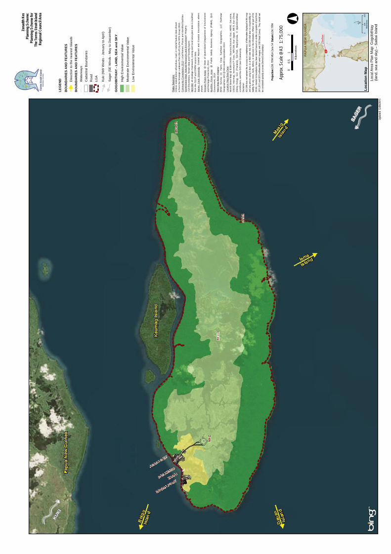
Zena
dth
Kes
Plan
ning
Sch
eme:
Plan
ning
Sch
eme f
orTh
e Tor
res S
trait
Islan
dRe
gion
al Co
uncil
Are
a
LEG
END
BO
UN
DA
RIE
S A
ND
FEA
TUR
ESD
irect
ion
to th
e ne
ares
t Isl
ands
BO
UN
DA
RIE
S A
ND
FEA
TUR
ESW
ater
way
sC
adas
tral B
ound
arie
sR
oad
LGA
PAPU
A N
EW G
UIN
EA
Saib
ai
Loca
tion
Map
Loca
l Are
a Pl
an M
ap: G
ogob
ithia
y (la
nd, s
ea a
nd s
ky) –
Sai
bai I
slan
d´0
100
200
Kilo
met
res
Kuki
(NW
Win
ds -
Janu
ary
to A
pril)
Sage
r (S
E W
inds
- M
ay to
Dec
embe
r)
KUKI
SAGE
R
GO
GO
BIT
HIA
Y - L
AN
D, S
EA a
nd S
KY
Hig
h E
nviro
nmen
tal V
alue
Mod
erat
e E
nviro
nmen
tal V
alue
Low
Env
ironm
enta
l Val
ue
01
20.
5 Kilo
met
res
°
Proj
ectio
n:GD
A 19
94 M
GA Z
one 5
4 Da
tum
:GDA
1994
Upda
ted:
12/0
8/20
15
1:75
,000
Appr
ox. S
cale
@A3
Dat
a S
ourc
es:
Unl
ess
stat
ed b
elow
all
land
use,
road
, or n
atur
al fe
atur
e da
ta s
how
nis
from
the
Stra
tegi
c La
ndus
e P
lan
(SLU
P) b
y th
e R
PS
Gro
up 2
010.
Com
mun
ity C
onsu
ltatio
n 20
13: L
ocal
Nam
es, P
lace
s an
d id
entif
ied
faci
litie
sQ
ueen
slan
d D
ept.
Nat
ural
Res
ourc
es a
nd E
nviro
nmen
t:Im
ager
y,LG
A B
ound
arie
s, T
erra
in d
ata
and
Floo
ding
laye
rsA
EC
OM
: all
stra
tegi
c fra
mew
ork,
zon
ing
and
loca
l are
a pl
an d
ata
is m
odifi
edfro
m th
e S
LUP
and
DN
RM
sou
rce
data
.Ja
mes
Coo
k U
nive
rsity
:C
oast
al H
azar
d an
d C
oast
al I
nnun
datio
n w
here
show
n.E
rosi
on P
rone
Are
as:
@ S
tate
of
Que
ensl
and
(Dep
artm
ent
of E
nviro
nmen
tan
d H
erita
ge P
rote
ctio
n), 2
014
Bus
hfire
P
rone
Are
a:@
Pub
lic
Saf
ety
Bus
ines
s A
genc
y (P
SB
A),
QLD
Gov
ernm
ent,
2014
Mai
n M
ap B
ase
Imag
ery:
BIN
G
Ser
vice
(c
) H
arris
C
orp,
E
arth
star
G
eogr
aphi
cs,
LLC
E
arth
star
Geo
grap
hics
SIO
@ M
icro
soft
Cor
pora
tion
2014
Loca
tion
Map
Bas
e D
ata:
Wor
ld S
treet
Map
@ E
SR
I Onl
ine.
Sou
rces
:Sou
rces
: Esr
i, H
ER
E, D
eLor
me,
US
GS
, Int
erm
ap, i
ncre
men
t P C
orp.
, N
RC
AN
, Esr
i Jap
an, M
ETI
, Esr
i Chi
na(H
ong
Kon
g),
Esr
i (T
haila
nd),
Tom
Tom
, M
apm
yInd
ia,
© O
penS
treet
Map
cont
ribut
ors,
and
the
GIS
Use
r Com
mun
ityDi
sclai
mer
:AE
COM
doe
s no
t war
rant
the
accu
racy
or c
omple
tene
ss o
f inf
orm
ation
disp
layed
in th
is m
apan
d an
y pe
rson
usin
g it
does
so
at th
eir o
wn ri
sk. A
ECOM
sha
ll be
ar n
o re
spon
sibilit
y or
liabil
ity fo
r any
erro
rs, f
aults
, def
ects,
or o
miss
ions
in th
e inf
orm
ation
. Whe
re n
ot p
art o
f the
DCDB
, int
erna
l lot
bou
ndar
ies h
ave
been
der
ived
base
d on
visi
ble o
ccup
ation
of l
and
from
2011
,201
2 an
d 20
13 o
rthor
ectifi
ed a
erial
imag
ery
and
CAD
Deta
il Su
rvey.
The
y sh
ould
not
be co
nside
red
spat
ially
accu
rate
(Der
ived
Lot B
ound
ary)
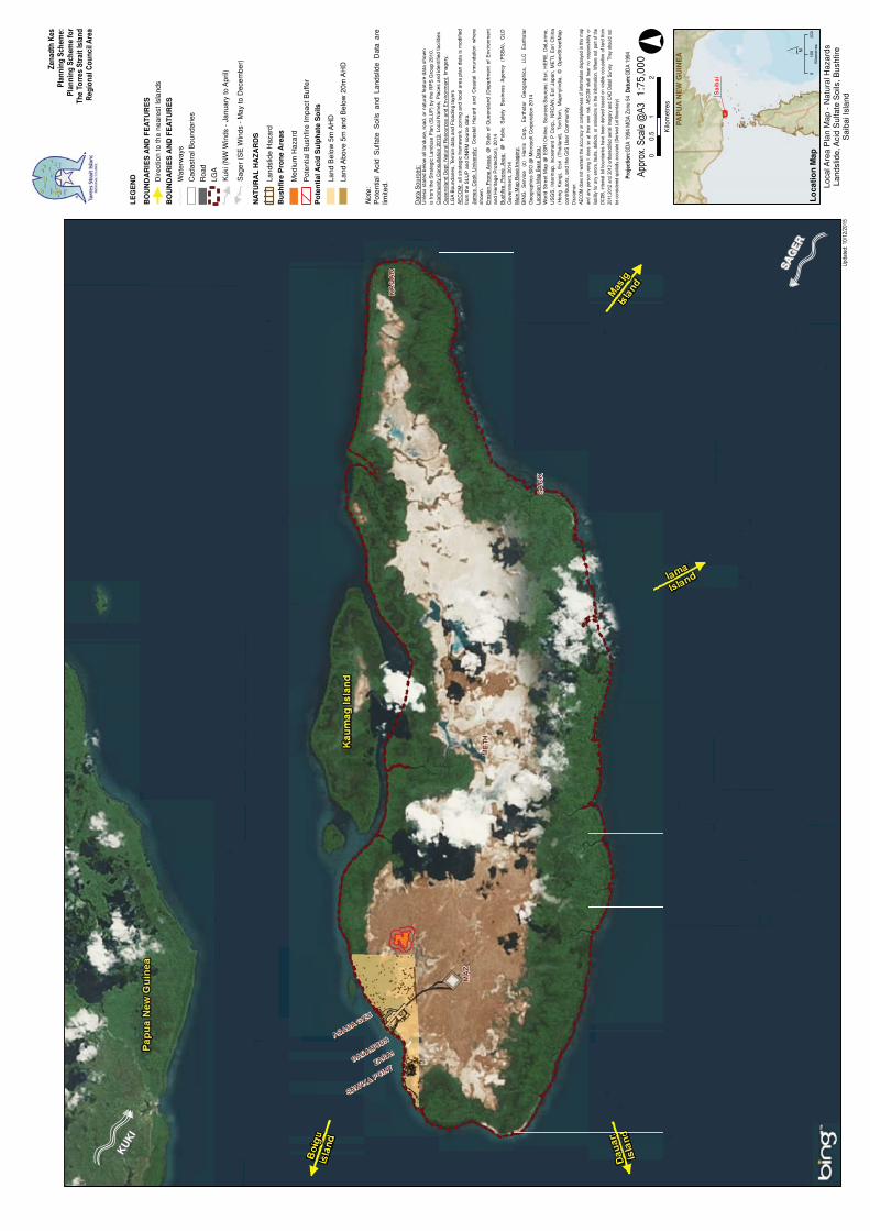
LE
GE
ND
BO
UN
DA
RIE
S A
ND
FE
AT
UR
ES
Dire
ctio
n to
the
near
est I
slan
ds
BO
UN
DA
RIE
S A
ND
FE
AT
UR
ES
Wat
erw
ays
Cad
astr
al B
ound
arie
s
Roa
d
LGA
PAP
UA
NE
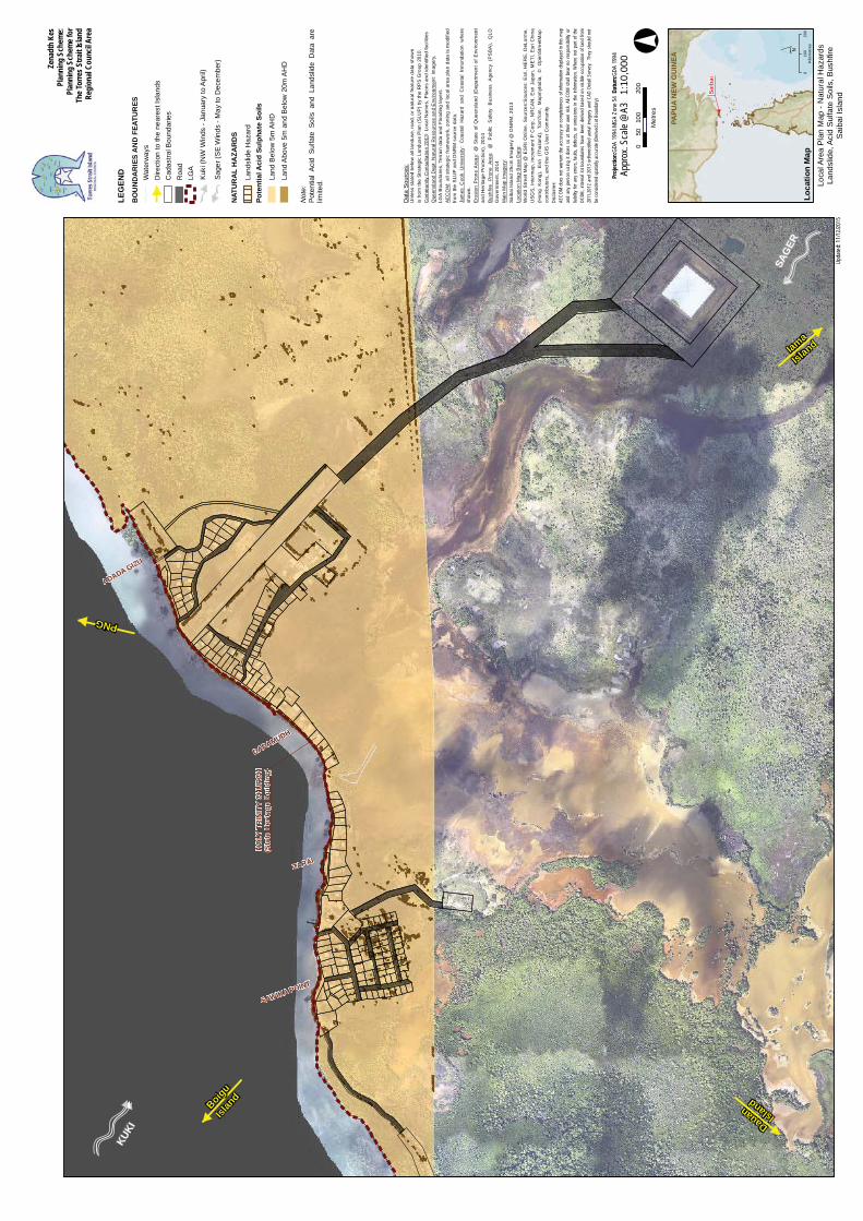
W G
UIN
EA
Sai
bai
Lo
cati
on
Map
Loca
l Are
a P
lan
Map
- N
atur
al H
azar
dsLa
ndsl
ide,
Aci
d S
ulfa
te S
oils
, Bus
hfire
Sai
bai I
slan
d
010
020
0K
ilom
etre
s
Kuk
i (N
W W
inds
- J
anua
ry to
Apr
il)
Sag
er (
SE
Win
ds -
May
to D
ecem
ber)
KU
KI
SAG
ER
NA
TU
RA
L H
AZ
AR
DS
Land
slid
e H
azar
d
Bu
shfi
re P
ron
e A
reas
Med
ium
Haz
ard
Pot
entia
l Bus
hfire
Impa
ct B
uffe
r
Po
ten
tial
Aci
d S
ulp
hat
e S
oils
Land
Bel
ow 5
m A
HD
Land
Abo
ve 5
m a
nd B
elow
20m
AH
D
01
20.
5 Kilo
met
res
Dat
a S
ourc
es:
Unl
ess
stat
ed b
elow
all
land
use,
roa
d, o
r n
atu
ral f
eatu
re d
ata
sho
wn
is fr
om t
he S
trat
egic
Lan
duse
Pla
n (S
LUP
) by
the
RP
S G
roup
201
0.C
omm
unity
Con
sulta
tion
2013
: Loc
al N
ames
, Pla
ces
and
iden
tifie
d fa
cilit
ies
Que
ensl
and
Dep
t. N
atur
al R
esou
rces
and
En
viro
nmen
t:Im
ager
y,LG
A B
ound
arie
s, T
erra
in d
ata
and
Flo
odin
g la
yers
AE
CO
M:
all s
trat
egic
fra
mew
ork
, zo
ning
and
loca
l are
a p
lan
data
is m
odifi
ed
from
the
SLU
P a
nd D
NR
M s
ourc
e da
ta.
Jam
es C
ook
Uni
vers
ity:
Coa
sta
l H
azar
d a
nd C
oast
al I
nnu
ndat
ion
wh
ere
show
n.E
rosi
on
Pro
ne A
reas
:@
Sta
te o
f Q
uee
nsla
nd
(Dep
art
men
t of
Env
ironm
ent
and
Her
itage
Pro
tect
ion)
, 20
14B
ushf
ire
Pro
ne A
rea:
@
Pub
lic
Saf
ety
B
usin
ess
Age
ncy
(P
SB
A),
Q
LDG
over
nmen
t, 20
14M
ain
Map
Bas
e Im
ager
y:B
ING
S
ervi
ce
(c)
Har
ris
Co
rp,
Ear
thst
ar
Geo
grap
hics
, LL
C
Ear
thst
arG
eogr
aphi
cs S
IO @
Mic
roso
ft C
orpo
ratio
n 2
014
Loca
tion
Map
Bas
e D
ata:
Wor
ld S
tre
et M
ap @
ES
RI
Onl
ine
. S
ourc
es:S
ourc
es:
Esr
i, H
ER
E,
DeL
orm
e,U
SG
S,
Inte
rmap
, in
crem
ent
P C
orp.
, N
RC
AN
, E
sri J
apan
, M
ET
I, E
sri C
hina
(Ho
ng
Kon
g),
Esr
i (T
haila
nd),
Tom
Tom
, M
apm
yIn
dia,
©
O
pen
Str
eetM
ap
cont
ribut
ors,
an
d th
e G
IS U
ser
Com
mu
nity
1:75
,000
Not
e:P
oten
tial
Aci
d S
ulfa
te S
oils
and
Lan
dslid
e D
ata
are
limite
d.
HO
LY T
RIN
ITY
CH
UR
CH
(Sta
te H
erita
ge B
uild
ing)
DADAMUDH
ZARAI
SAWIKA POINT
ADADA GIZU
Boigu
Islan
d
Iama
Island
Dauan Island
PNG
Zena
dth
Kes
Plan
ning
Sch
eme:
Plan
ning
Sch
eme f
orTh
e Tor
res S
trait
Islan
dRe
gion
al Co
uncil
Are
a
LEG
END
BO
UN
DA
RIE
S A
ND
FEA
TUR
ESW
ater
way
sD
irect
ion
to th
e ne
ares
t Isl
ands
Cad
astra
l Bou
ndar
ies
Roa
dLG
A
PAPU
A N
EW G
UIN
EA
Saib
ai
Loca
tion
Map
Loca
l Are
a P
lan
Map
- N
atur
al H
azar
dsLa
ndsl
ide,
Aci
d S
ulfa
te S
oils
, Bus
hfire
Sai
bai I
slan
d
´0
100
200
Kilo
met
res
Kuki
(NW
Win
ds -
Janu
ary
to A
pril)
Sage
r (S
E W
inds
- M
ay to
Dec
embe
r)
KUKI
SAG
ER
NAT
UR
AL
HA
ZAR
DS
Land
slid
e H
azar
dPo
tent
ial A
cid
Sulp
hate
Soi
ls
Land
Bel
ow 5
m A
HD
Land
Abo
ve 5
m a
nd B
elow
20m
AH
D
010
020
050
Met
res
°Pr
ojec
tion:
GDA
1994
MGA
Zon
e 54
Datu
m:G
DA 19
94
Upda
ted:
11/12
/2015
Dat
a S
ourc
es:
Unl
ess
stat
ed b
elow
all
land
use,
road
, or n
atur
al fe
atur
e da
ta s
how
nis
from
the
Stra
tegi
c La
ndus
e P
lan
(SLU
P) b
y th
e R
PS
Gro
up 2
010.
Com
mun
ity C
onsu
ltatio
n 20
13: L
ocal
Nam
es, P
lace
s an
d id
entif
ied
faci
litie
sQ
ueen
slan
d D
ept.
Nat
ural
Res
ourc
es a
nd E
nviro
nmen
t:Im
ager
y,LG
A B
ound
arie
s, T
erra
in d
ata
and
Floo
ding
laye
rsAE
CO
M: a
ll st
rate
gic
fram
ewor
k, z
onin
g an
d lo
cal a
rea
plan
dat
a is
mod
ified
from
the
SLU
P a
nd D
NR
M s
ourc
e da
ta.
Jam
es C
ook
Uni
vers
ity:
Coa
stal
Haz
ard
and
Coa
stal
Inn
unda
tion
whe
resh
own.
Eros
ion
Pro
ne A
reas
:@
Sta
te o
f Q
ueen
slan
d (D
epar
tmen
t of
Env
ironm
ent
and
Her
itage
Pro
tect
ion)
, 201
4Bu
shfir
e P
rone
Are
a:@
Pub
lic S
afet
y B
usin
ess
Age
ncy
(PS
BA
), Q
LDG
over
nmen
t, 20
14M
ain
Map
Imag
ery:
Saib
ai Is
land
25c
m Im
ager
y @
DN
RM
, 201
3Lo
catio
n M
ap B
ase
Dat
a:W
orld
Stre
et M
ap @
ES
RI O
nlin
e. S
ourc
es:S
ourc
es: E
sri,
HE
RE
, DeL
orm
e,U
SGS
, Int
erm
ap, i
ncre
men
t P C
orp.
, NR
CA
N, E
sri J
apan
, ME
TI, E
sri C
hina
(Hon
g K
ong)
, E
sri
(Tha
iland
), To
mTo
m,
Map
myI
ndia
, ©
Ope
nStre
etM
apco
ntrib
utor
s, a
nd th
e G
IS U
ser C
omm
unity
Disc
laim
er:
AECO
M d
oes
not w
arra
nt th
e ac
cura
cy o
r com
plete
ness
of i
nfor
mat
ion
displ
ayed
in th
is m
apan
d an
y pe
rson
usin
g it
does
so
at th
eir o
wn r
isk. A
ECOM
sha
ll be
ar n
o re
spon
sibilit
y or
liabil
ity fo
r any
erro
rs, f
aults
, def
ects,
or o
miss
ions
in th
e inf
orm
atio
n. W
here
not
par
t of t
heDC
DB, i
nter
nal l
ot b
ound
aries
hav
e be
en d
erive
d ba
sed
on v
isible
occ
upat
ion
of la
nd fr
om20
11,2
012
and
2013
orth
orec
tified
aer
ial im
ager
y an
d CA
D De
tail
Surv
ey.
They
sho
uld n
otbe
con
sider
ed sp
atial
ly ac
cura
te (D
erive
d Lo
t Bou
ndar
y)
Not
e:Po
tent
ial
Acid
Sul
fate
Soi
ls a
nd L
ands
lide
Dat
a ar
elim
ited.
Appr
ox. S
cale
@A3
1:
10,0
00
Zena
dth
Kes
Plan
ning
Sch
eme:
Plan
ning
Sch
eme f
orTh
e Tor
res S
trait
Islan
dRe
gion
al Co
uncil
Are
a
LEG
END
BO
UN
DA
RIE
S A
ND
FEA
TUR
ESD
irect
ion
to th
e ne
ares
t Isl
ands
BO
UN
DA
RIE
S A
ND
FEA
TUR
ESW
ater
way
sC
adas
tral B
ound
arie
sR
oad
LGA
PAPU
A N
EW G
UIN
EA
Saib
ai
Loca
tion
Map
Loca
l Are
a P
lan
Map
- N
atur
al H
azar
dsC
oast
al H
azar
d A
reas
and
Flo
odS
aiba
i Isl
and
´0
100
200
Kilo
met
res
Kuki
(NW
Win
ds -
Janu
ary
to A
pril)
Sage
r (S
E W
inds
- M
ay to
Dec
embe
r)
KUKI
SAG
ER
01
20.
5 Kilo
met
res
°Pr
ojec
tion:
GDA
1994
MGA
Zon
e 54
Datu
m:G
DA 19
94
Upda
ted:
15/03
/2016
Dat
a S
ourc
es:
Unl
ess
stat
ed b
elow
all
land
use,
road
, or n
atur
al fe
atur
e da
ta s
how
nis
from
the
Stra
tegi
c La
ndus
e P
lan
(SLU
P) b
y th
e R
PS
Gro
up 2
010.
Com
mun
ity C
onsu
ltatio
n 20
13: L
ocal
Nam
es, P
lace
s an
d id
entif
ied
faci
litie
sQ
ueen
slan
d D
ept.
Nat
ural
Res
ourc
es a
nd E
nviro
nmen
t:Im
ager
y,LG
A B
ound
arie
s, T
erra
in d
ata
and
Floo
ding
laye
rsAE
CO
M: a
ll st
rate
gic
fram
ewor
k, z
onin
g an
d lo
cal a
rea
plan
dat
a is
mod
ified
from
the
SLU
P a
nd D
NR
M s
ourc
e da
ta.
Jam
es C
ook
Uni
vers
ity:
Coa
stal
Haz
ard
and
Coa
stal
Inn
unda
tion
whe
resh
own.
Eros
ion
Pro
ne
Area
(v
5):
@
Sta
te
of
Que
ensl
and
(Dep
artm
ent
ofEn
viro
nmen
t and
Her
itage
Pro
tect
ion)
, 8/0
7/20
15M
ain
Map
Bas
e Im
ager
y:BI
NG
S
ervi
ce
(c)
Har
ris
Cor
p,
Ear
thst
ar
Geo
grap
hics
, LL
C
Ear
thst
arG
eogr
aphi
cs S
IO @
Mic
roso
ft C
orpo
ratio
n 20
14Lo
catio
n M
ap B
ase
Dat
a:W
orld
Stre
et M
ap @
ES
RI O
nlin
e. S
ourc
es:S
ourc
es: E
sri,
HE
RE
, DeL
orm
e,U
SGS
, Int
erm
ap, i
ncre
men
t P C
orp.
, NR
CA
N, E
sri J
apan
, ME
TI, E
sri C
hina
(Hon
g K
ong)
, E
sri
(Tha
iland
), To
mTo
m,
Map
myI
ndia
, ©
Ope
nStre
etM
apco
ntrib
utor
s, a
nd th
e G
IS U
ser C
omm
unity
Disc
laim
er:
AECO
M d
oes
not w
arra
nt th
e ac
cura
cy o
r com
plete
ness
of i
nfor
mat
ion
displ
ayed
in th
is m
apan
d an
y pe
rson
usin
g it
does
so
at th
eir o
wn r
isk. A
ECOM
sha
ll be
ar n
o re
spon
sibilit
y or
liabil
ity fo
r any
erro
rs, f
aults
, def
ects,
or o
miss
ions
in th
e inf
orm
atio
n. W
here
not
par
t of t
heDC
DB, i
nter
nal l
ot b
ound
aries
hav
e be
en d
erive
d ba
sed
on v
isible
occ
upat
ion
of la
nd fr
om20
11,2
012
and
2013
orth
orec
tified
aer
ial im
ager
y an
d CA
D De
tail
Surv
ey.
They
sho
uld n
otbe
con
sider
ed sp
atial
ly ac
cura
te (D
erive
d Lo
t Bou
ndar
y)
FUTU
RE
INFR
AST
RU
CTU
RE
Indi
cativ
e Fu
ture
Loc
atio
n fo
r Sea
Wal
l In
dica
tive
Futu
re L
ocat
ion
for B
und
Wal
l
1:75
,000
Appr
ox. S
cale
@A3
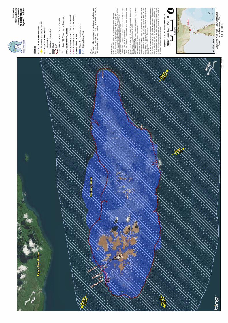
Not
e:Th
e st
orm
tide
inun
datio
n ar
eas
incl
ude
the
land
are
alik
ely
to b
e co
vere
d by
a 0
.8 m
sea
leve
l ris
e an
d a
100
year
sto
rm ti
de re
turn
per
iod.
Eros
ion
Pro
ne A
rea
Coa
stal
Haz
ard
Are
as
Stor
m T
ide
Inun
datio
n A
rea
HO
LY T
RIN
ITY
CH
UR
CH
(Sta
te H
erita
ge B
uild
ing)
DADAMUDH
ZARAI
SAWIKA POINT
ADADA GIZU
Boigu
Islan
d
Iama
Island
Dauan Island
PNG
Zena
dth
Kes
Plan
ning
Sch
eme:
Plan
ning
Sch
eme f
orTh
e Tor
res S
trait
Islan
dRe
gion
al Co
uncil
Are
a
LEG
END
BO
UN
DA
RIE
S A
ND
FEA
TUR
ESW
ater
way
sD
irect
ion
to th
e ne
ares
t Isl
ands
Cad
astra
l Bou
ndar
ies
Roa
dLG
A
PAPU
A N
EW G
UIN
EA
Saib
ai
Loca
tion
Map
Loca
l Are
a P
lan
Map
- N
atur
al H
azar
dsC
oast
al H
azar
d A
reas
and
Flo
odS
aiba
i Tow
nshi
p
´0
100
200
Kilo
met
res
Kuki
(NW
Win
ds -
Janu
ary
to A
pril)
Sage
r (S
E W
inds
- M
ay to
Dec
embe
r)
KUKI
SAG
ER
010
020
050
Met
res
°Pr
ojec
tion:
GDA
1994
MGA
Zon
e 54
Datu
m:G
DA 19
94
Upda
ted:
15/03
/2016
Dat
a S
ourc
es:
Unl
ess
stat
ed b
elow
all
land
use,
road
, or n
atur
al fe
atur
e da
ta s
how
nis
from
the
Stra
tegi
c La
ndus
e P
lan
(SLU
P) b
y th
e R
PS
Gro
up 2
010.
Com
mun
ity C
onsu
ltatio
n 20
13: L
ocal
Nam
es, P
lace
s an
d id
entif
ied
faci
litie
sQ
ueen
slan
d D
ept.
Nat
ural
Res
ourc
es a
nd E
nviro
nmen
t:Im
ager
y,LG
A B
ound
arie
s, T
erra
in d
ata
and
Floo
ding
laye
rsAE
CO
M: a
ll st
rate
gic
fram
ewor
k, z
onin
g an
d lo
cal a
rea
plan
dat
a is
mod
ified
from
the
SLU
P a
nd D
NR
M s
ourc
e da
ta.
Jam
es C
ook
Uni
vers
ity:
Coa
stal
Haz
ard
and
Coa
stal
Inn
unda
tion
whe
resh
own.
Eros
ion
Pro
ne
Area
(v
5):
@
Sta
te
of
Que
ensl
and
(Dep
artm
ent
ofEn
viro
nmen
t and
Her
itage
Pro
tect
ion)
, 8/0
7/20
15M
ain
Map
Imag
ery:
Saib
ai Is
land
25c
m Im
ager
y @
DN
RM
, 201
3Lo
catio
n M
ap B
ase
Dat
a:W
orld
Stre
et M
ap @
ES
RI O
nlin
e. S
ourc
es:S
ourc
es: E
sri,
HE
RE
, DeL
orm
e,U
SGS
, Int
erm
ap, i
ncre
men
t P C
orp.
, NR
CA
N, E
sri J
apan
, ME
TI, E
sri C
hina
(Hon
g K
ong)
, E
sri
(Tha
iland
), To
mTo
m,
Map
myI
ndia
, ©
Ope
nStre
etM
apco
ntrib
utor
s, a
nd th
e G
IS U
ser C
omm
unity
Disc
laim
er:
AECO
M d
oes
not w
arra
nt th
e ac
cura
cy o
r com
plete
ness
of i
nfor
mat
ion
displ
ayed
in th
is m
apan
d an
y pe
rson
usin
g it
does
so
at th
eir o
wn r
isk. A
ECOM
sha
ll be
ar n
o re
spon
sibilit
y or
liabil
ity fo
r any
erro
rs, f
aults
, def
ects,
or o
miss
ions
in th
e inf
orm
atio
n. W
here
not
par
t of t
heDC
DB, i
nter
nal l
ot b
ound
aries
hav
e be
en d
erive
d ba
sed
on v
isible
occ
upat
ion
of la
nd fr
om20
11,2
012
and
2013
orth
orec
tified
aer
ial im
ager
y an
d CA
D De
tail
Surv
ey.
They
sho
uld n
otbe
con
sider
ed sp
atial
ly ac
cura
te (D
erive
d Lo
t Bou
ndar
y)
FUTU
RE
INFR
AST
RU
CTU
RE
Indi
cativ
e Fu
ture
Loc
atio
n fo
r Sea
Wal
l In
dica
tive
Futu
re L
ocat
ion
for B
und
Wal
l
Not
e:Th
e st
orm
tide
inun
datio
n ar
eas
incl
ude
the
land
are
alik
ely
to b
e co
vere
d by
a 0
.8 m
sea
leve
l ris
e an
d a
100
year
sto
rm ti
de re
turn
per
iod.
Eros
ion
Pro
ne A
rea
Coa
stal
Haz
ard
Are
as
Stor
m T
ide
Inun
datio
n A
rea 1:
10,0
00Ap
prox
. Sca
le @
A3


![]oogle Maps Google maps Hataor Osland stfial Distri 'Vest Get Google Maps … · 2011. 5. 15. · Google maps Hataor Osland stfial Distri 'Vest Get Google Maps on your phone "GMAPS"t046þ453](https://img.pdfslide.tips/doc/110x75/6033290187ae2e30bc06dc6c/oogle-maps-google-maps-hataor-osland-stfial-distri-vest-get-google-maps-2011.jpg)