Embed Size (px)
Citation preview
Chapter 11 Mountain Building
Section 1 Rock Deformation
Key Concepts
What determines the strength of a rock? What are the types of stresses that affect rocks? What are the three main types of folds? What are the main types of faults?
Vocabulary
deformation stress strain anticline syncline monocline normal fault reverse fault thrust fault strike-slip fault
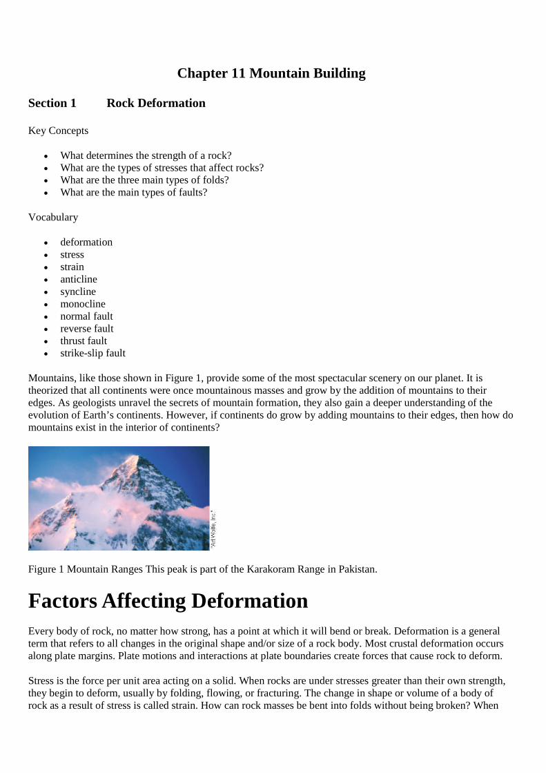
Mountains, like those shown in Figure 1, provide some of the most spectacular scenery on our planet. It istheorized that all continents were once mountainous masses and grow by the addition of mountains to theiredges. As geologists unravel the secrets of mountain formation, they also gain a deeper understanding of theevolution of Earth’s continents. However, if continents do grow by adding mountains to their edges, then how domountains exist in the interior of continents?
Figure 1 Mountain Ranges This peak is part of the Karakoram Range in Pakistan.
Factors Affecting DeformationEvery body of rock, no matter how strong, has a point at which it will bend or break. Deformation is a generalterm that refers to all changes in the original shape and/or size of a rock body. Most crustal deformation occursalong plate margins. Plate motions and interactions at plate boundaries create forces that cause rock to deform.
Stress is the force per unit area acting on a solid. When rocks are under stresses greater than their own strength,they begin to deform, usually by folding, flowing, or fracturing. The change in shape or volume of a body ofrock as a result of stress is called strain. How can rock masses be bent into folds without being broken? When
stress is gradually applied, rocks first respond by deforming elastically. Changes that result from elasticdeformation are recoverable. Like a rubber band, the rock will return to almost its original size and shape oncethe force is removed. Once the elastic limit or strength of a rock is surpassed, it either flows or fractures. Thefactors that influence the strength of a rock and how it will deform include temperature, confining pressure, rocktype, and time.
Temperature and Pressure
Rocks deform permanently in two ways: brittle deformation and ductile deformation. Rocks near the surface,where temperatures and confining pressures are low, usually behave like brittle solids and fracture once theirstrength is exceeded. This type of deformation is called brittle failure or brittle deformation. You know that glassobjects, wooden pencils, china plates, and even our bones show brittle failure once their strength is exceeded.
At depth, where temperatures and confining pressures are high, rocks show ductile behavior. Ductiledeformation is a type of solid-state flow that produces a change in the size and shape of an object withoutfracturing the object. Objects that display ductile behavior include modeling clay, bee’s wax, caramel candy, andmost metals. For example, a copper penny placed on a railroad track will be flattened and deformed withoutbreaking by the force applied by a passing train. Ductile deformation of a rock that is strongly aided by hightemperature and high confining pressure is somewhat similar to the deformation of a penny flattened by a train.
Rock Type
The mineral composition and texture of a rock also greatly affect how it will deform. Rocks like granite andbasalt that are composed of minerals with strong internal molecular bonds usually fail by brittle fracture.Sedimentary rocks that are weakly cemented or metamorphic rocks that contain zones of weakness—such asfoliation—are more likely to deform by ductile flow. Rocks that are weak and most likely behave in a ductilemanner when under force include rock salt, gypsum, and shale. Limestone, schist, and marble are of intermediatestrength and may also behave in a ductile manner.
Time
In nature small stresses applied over long time spans play an important role in the deformation of rock. You cansee the effects of time on deformation in everyday settings. For example, marble benches have been known tosag under their own weight over a span of a hundred years or so. Forces that are unable to deform rock when firstapplied may cause rock to flow if the force is maintained over a long period of time.
Types of StressRocks are exposed to many different forces due to plate motions. The three types of stresses that rockscommonly undergo are tensional stress, compressional stress, and shear stress. Look at Figure 2. When rocks aresqueezed or shortened the stress is compressional. Tensional stress is caused by rocks being pulled in oppositedirections. Shear stress causes a body of rock to be distorted.
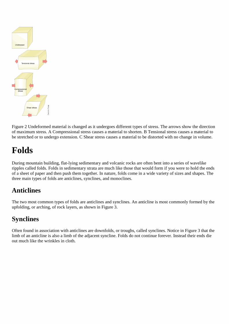
Figure 2 Undeformed material is changed as it undergoes different types of stress. The arrows show the directionof maximum stress. A Compressional stress causes a material to shorten. B Tensional stress causes a material tobe stretched or to undergo extension. C Shear stress causes a material to be distorted with no change in volume.
Folds
During mountain building, flat-lying sedimentary and volcanic rocks are often bent into a series of wavelikeripples called folds. Folds in sedimentary strata are much like those that would form if you were to hold the endsof a sheet of paper and then push them together. In nature, folds come in a wide variety of sizes and shapes. Thethree main types of folds are anticlines, synclines, and monoclines.
Anticlines
The two most common types of folds are anticlines and synclines. An anticline is most commonly formed by theupfolding, or arching, of rock layers, as shown in Figure 3.
Synclines
Often found in association with anticlines are downfolds, or troughs, called synclines. Notice in Figure 3 that thelimb of an anticline is also a limb of the adjacent syncline. Folds do not continue forever. Instead their ends dieout much like the wrinkles in cloth.

Figure 3 Anticlines and Synclines The upfolded or arched structures are anticlines. The downfolds or troughs aresynclines. Notice that the limb of an anticline is also the limb of the adjacent syncline.
Monoclines
Although we will discuss folds and faults separately, in the real world folds are generally closely associated withfaults. Examples of this close association are broad, regional features called monoclines. Monoclines are large,step-like folds in otherwise horizontal sedimentary strata. Monoclines seem to occur as sedimentary layers havebeen folded over a large faulted block of underlying rock. Monoclines are prominent features of the ColoradoPlateau area in Colorado, New Mexico, Utah, and Arizona, as shown in Figure 4 on the next page.
Figure 4 Monocline A Monocline located near Mexican Hat, Utah. B This monocline consists of bentsedimentary beds that were deformed by faulting in the bedrock below.
Recall that faults are fractures in the crust along which movement has taken place. Small faults can berecognized in road cuts where sedimentary beds have been offset a few meters, as shown in Figure 5. Faults ofthis size usually occur as single breaks. By contrast, large faults, like the San Andreas fault in California, havedisplacements of hundreds of kilometers and consist of many interconnecting fault surfaces. These fault zonescan be many kilometers wide and are often easier to identify from high-altitude photographs than at ground level.
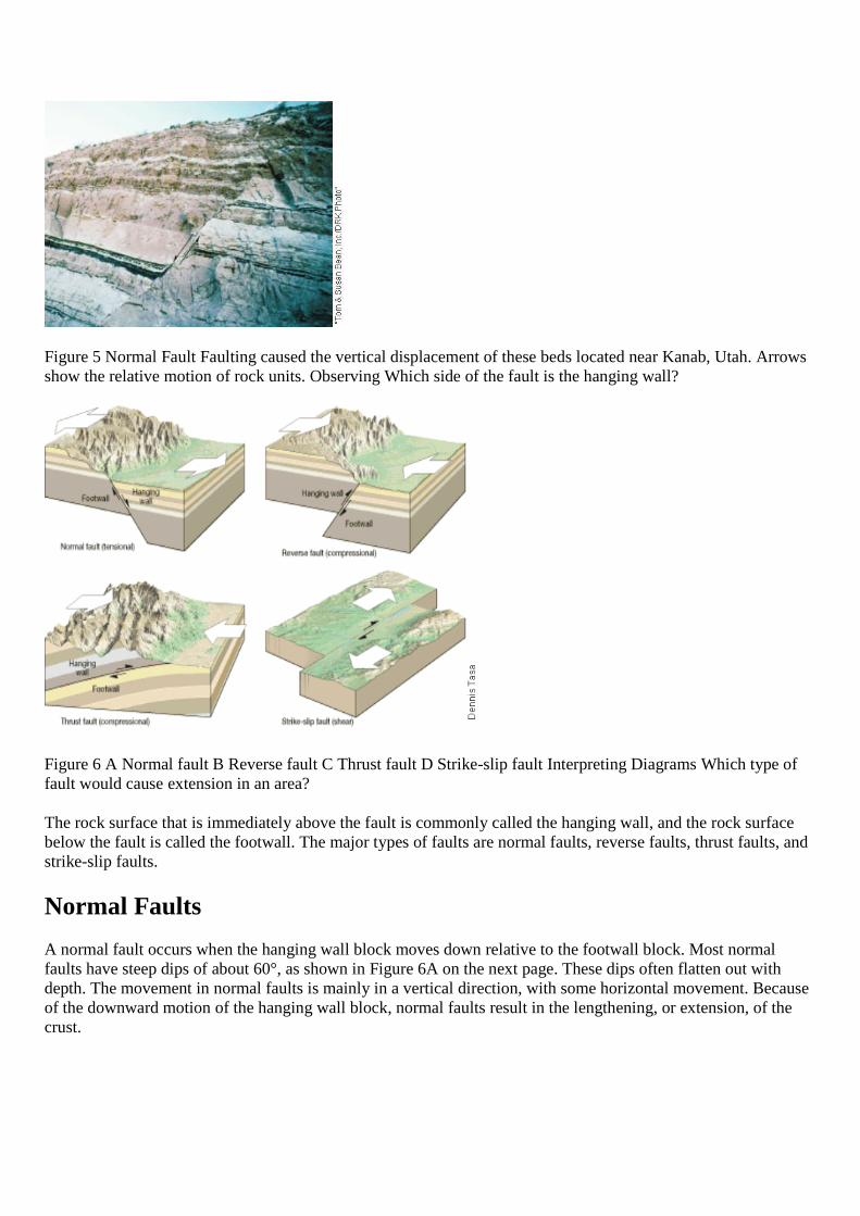
Figure 5 Normal Fault Faulting caused the vertical displacement of these beds located near Kanab, Utah. Arrowsshow the relative motion of rock units. Observing Which side of the fault is the hanging wall?
Figure 6 A Normal fault B Reverse fault C Thrust fault D Strike-slip fault Interpreting Diagrams Which type offault would cause extension in an area?
The rock surface that is immediately above the fault is commonly called the hanging wall, and the rock surfacebelow the fault is called the footwall. The major types of faults are normal faults, reverse faults, thrust faults, andstrike-slip faults.
Normal Faults
A normal fault occurs when the hanging wall block moves down relative to the footwall block. Most normalfaults have steep dips of about 60°, as shown in Figure 6A on the next page. These dips often flatten out withdepth. The movement in normal faults is mainly in a vertical direction, with some horizontal movement. Becauseof the downward motion of the hanging wall block, normal faults result in the lengthening, or extension, of thecrust.
Reverse Faults and Thrust Faults
A reverse fault is a fault in which the hanging wall block moves up relative to the footwall block. Reverse faultsare high-angle faults with dips greater than 45°. Thrust faults are reverse faults with dips of less than 45°.Because the hanging wall block moves up and over the footwall block, reverse and thrust faults result in ashortening of the crust, as shown in Figure 6B and 6C.
Most high-angle reverse faults are small. They cause only local displacements in regions dominated by othertypes of faulting. Thrust faults, on the other hand, exist at all scales. In mountainous regions such as the Alps,northern Rockies, Himalayas, and Appalachians, thrust faults have displaced rock layers as far as 50 kilometersover adjacent rocks. The result of this large-scale movement is that older rocks end up on top of younger rocks.
Normal faults occur due to tensional stresses, and reverse and thrust faults result from compressional stresses.Compressional forces generally produce folds as well as faults. These compressional forces result in a thickeningand shortening of the rocks.
Q :How do you determine which side of a fault has moved?
A: For the fault shown in Figure 5, did the left side move down, or did the right side move up? Since the surfaceat the top of the photo has been eroded flat, either side could have moved, or both sides could have moved, withone side moving more than the other. That’s why geologists talk about relative motion across faults. In this case,the left side moved down relative to the right side, and the right side moved up relative to the left side.
Strike-Slip Faults
Faults in which the movement is horizontal and parallel to the trend, or strike, of the fault surface are calledstrike-slip faults, as shown in Figure 6D. Because of their large size and linear nature, many strike-slip faultsproduce a trace that is visible over a great distance. Rather than a single fracture, large strike-slip faults usuallyconsist of a zone of roughly parallel fractures. The zone may be up to several kilometers wide. The most recentmovement, however, is often along a section only a few meters wide, which may offset features such as streamchannels. Crushed and broken rocks produced during faulting are more easily eroded, often producing linearvalleys or troughs that mark the locations of strike-slip faults. Scientific records of strike-slip faulting were madefollowing surface ruptures that produced large earthquakes. Strike-slip faults are commonly caused by shearstress. The San Andreas fault in California and the Great Glen fault in Scotland are well-known examples ofstrike-slip faults.
Joints
Among the most common rock structures are fractures called joints. Unlike faults, joints are fractures alongwhich no appreciable movement has occurred. Although some joints have a random orientation, most occur inroughly parallel groups, as shown in Figure 7. Joints usually form as the result of large-scale regional stresses.
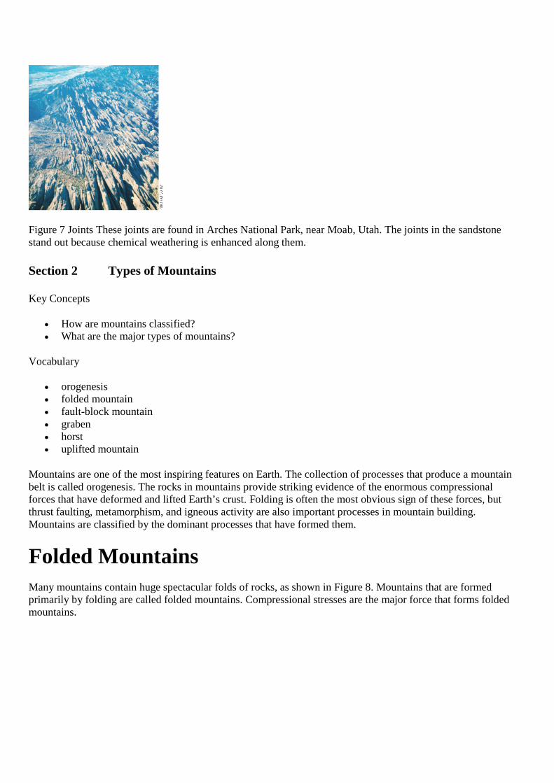
Figure 7 Joints These joints are found in Arches National Park, near Moab, Utah. The joints in the sandstonestand out because chemical weathering is enhanced along them.
Section 2 Types of Mountains
Key Concepts
How are mountains classified? What are the major types of mountains?
Vocabulary
orogenesis folded mountain fault-block mountain graben horst uplifted mountain
Mountains are one of the most inspiring features on Earth. The collection of processes that produce a mountainbelt is called orogenesis. The rocks in mountains provide striking evidence of the enormous compressionalforces that have deformed and lifted Earth’s crust. Folding is often the most obvious sign of these forces, butthrust faulting, metamorphism, and igneous activity are also important processes in mountain building.Mountains are classified by the dominant processes that have formed them.
Folded Mountains
Many mountains contain huge spectacular folds of rocks, as shown in Figure 8. Mountains that are formedprimarily by folding are called folded mountains. Compressional stresses are the major force that forms foldedmountains.

Figure 8 Folded Mountains Folded sedimentary layers are exposed in the northern Rocky Mountains on the faceof Mount Kidd, Alberta, Canada.
Thrust faulting is also important in the formation of folded mountains, which are often called fold-and-thrustbelts. Folded mountains often contain numerous stacked thrust faults that have displaced the folded rock layersmany kilometers horizontally. The Appalachian Mountains, the northern Rocky Mountains, and the Alps inEurope are examples of folded mountain ranges.
Fault-Block MountainsMost normal faults are small and have displacements of only a meter or so. Others extend for tens of kilometerswhere they may outline the boundary of a mountain front. Large-scale normal faults are associated withstructures called fault-block mountains. These mountains form as large blocks of crust are uplifted and tiltedalong normal faults.
In the western United States, examples of fault-block mountains include the Teton Range of Wyoming and theSierra Nevada of California. Both are faulted along their eastern flanks, which were uplifted as the blocks tilteddownward to the west. These steep mountain fronts were produced over a period of 5 million to 10 million yearsby many episodes of faulting. Each event produced just a few meters of displacement.
Normal faulting occurs where tensional stresses cause the crust to be stretched or extended. As the crust isstretched, a block called a graben, which is bounded by normal faults, drops down. Graben is the German wordfor ditch or trench. Grabens produce an elongated valley bordered by relatively uplifted structures called horsts.The Basin and Range Province of Nevada, Utah, and California, shown in Figure 9, is made of elongatedgrabens. Above the grabens, tilted fault-bound blocks or horsts produce linear fault-block mountains.
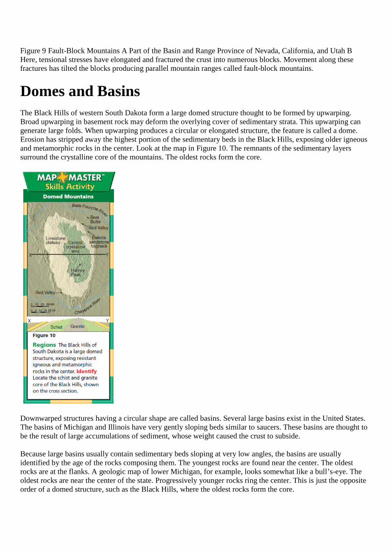
Figure 9 Fault-Block Mountains A Part of the Basin and Range Province of Nevada, California, and Utah BHere, tensional stresses have elongated and fractured the crust into numerous blocks. Movement along thesefractures has tilted the blocks producing parallel mountain ranges called fault-block mountains.
Domes and BasinsThe Black Hills of western South Dakota form a large domed structure thought to be formed by upwarping.Broad upwarping in basement rock may deform the overlying cover of sedimentary strata. This upwarping cangenerate large folds. When upwarping produces a circular or elongated structure, the feature is called a dome.Erosion has stripped away the highest portion of the sedimentary beds in the Black Hills, exposing older igneousand metamorphic rocks in the center. Look at the map in Figure 10. The remnants of the sedimentary layerssurround the crystalline core of the mountains. The oldest rocks form the core.
Downwarped structures having a circular shape are called basins. Several large basins exist in the United States.The basins of Michigan and Illinois have very gently sloping beds similar to saucers. These basins are thought tobe the result of large accumulations of sediment, whose weight caused the crust to subside.
Because large basins usually contain sedimentary beds sloping at very low angles, the basins are usuallyidentified by the age of the rocks composing them. The youngest rocks are found near the center. The oldestrocks are at the flanks. A geologic map of lower Michigan, for example, looks somewhat like a bull’s-eye. Theoldest rocks are near the center of the state. Progressively younger rocks ring the center. This is just the oppositeorder of a domed structure, such as the Black Hills, where the oldest rocks form the core.
Section 3 Mountain Formation
Key Concepts
What mountains are associated with convergent plate boundaries? What mountains are associated with divergent plate boundaries? How is isostatic adjustment involved in mountain formation?
Vocabulary
accretionary wedge accretion terrane isostasy isostatic adjustment
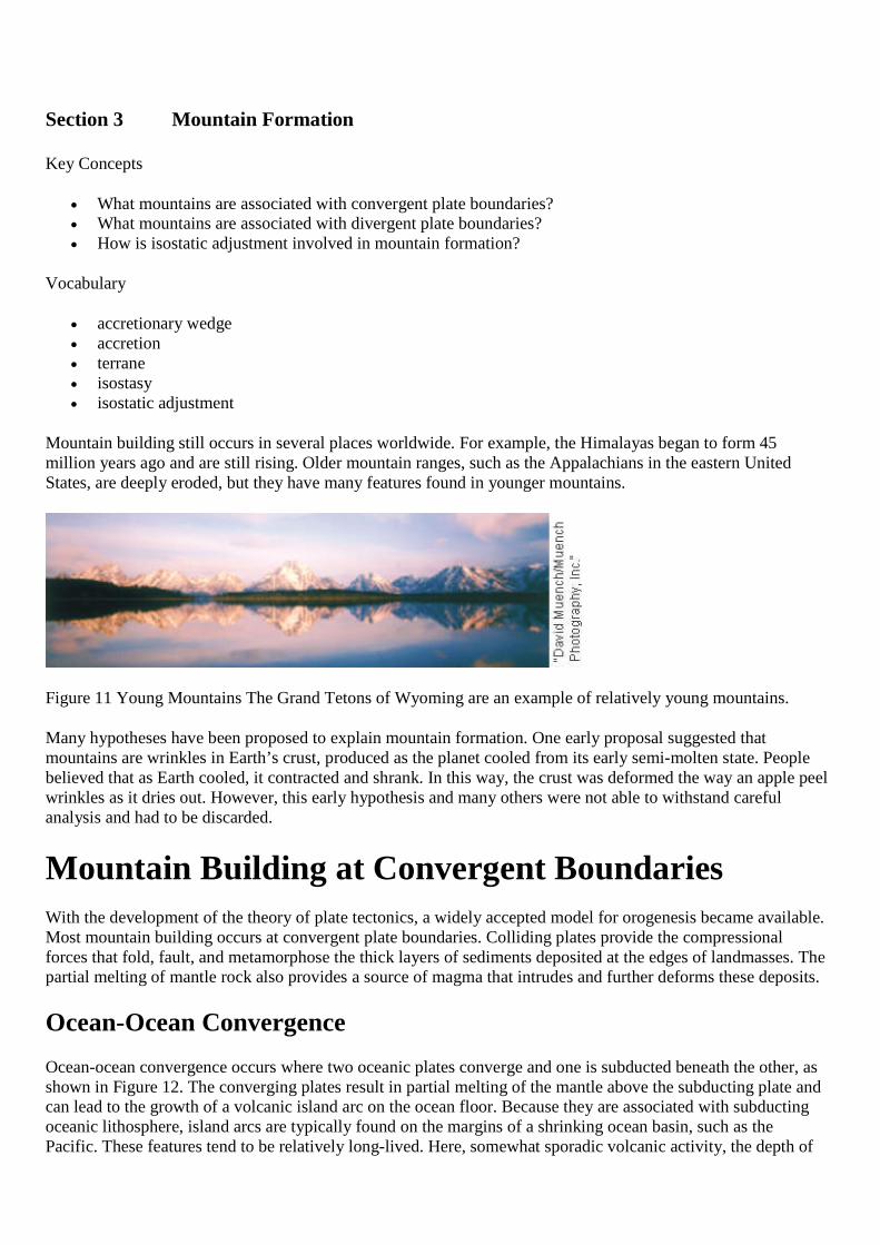
Mountain building still occurs in several places worldwide. For example, the Himalayas began to form 45million years ago and are still rising. Older mountain ranges, such as the Appalachians in the eastern UnitedStates, are deeply eroded, but they have many features found in younger mountains.
Figure 11 Young Mountains The Grand Tetons of Wyoming are an example of relatively young mountains.
Many hypotheses have been proposed to explain mountain formation. One early proposal suggested thatmountains are wrinkles in Earth’s crust, produced as the planet cooled from its early semi-molten state. Peoplebelieved that as Earth cooled, it contracted and shrank. In this way, the crust was deformed the way an apple peelwrinkles as it dries out. However, this early hypothesis and many others were not able to withstand carefulanalysis and had to be discarded.
Mountain Building at Convergent Boundaries
With the development of the theory of plate tectonics, a widely accepted model for orogenesis became available.Most mountain building occurs at convergent plate boundaries. Colliding plates provide the compressionalforces that fold, fault, and metamorphose the thick layers of sediments deposited at the edges of landmasses. Thepartial melting of mantle rock also provides a source of magma that intrudes and further deforms these deposits.
Ocean-Ocean Convergence
Ocean-ocean convergence occurs where two oceanic plates converge and one is subducted beneath the other, asshown in Figure 12. The converging plates result in partial melting of the mantle above the subducting plate andcan lead to the growth of a volcanic island arc on the ocean floor. Because they are associated with subductingoceanic lithosphere, island arcs are typically found on the margins of a shrinking ocean basin, such as thePacific. These features tend to be relatively long-lived. Here, somewhat sporadic volcanic activity, the depth of
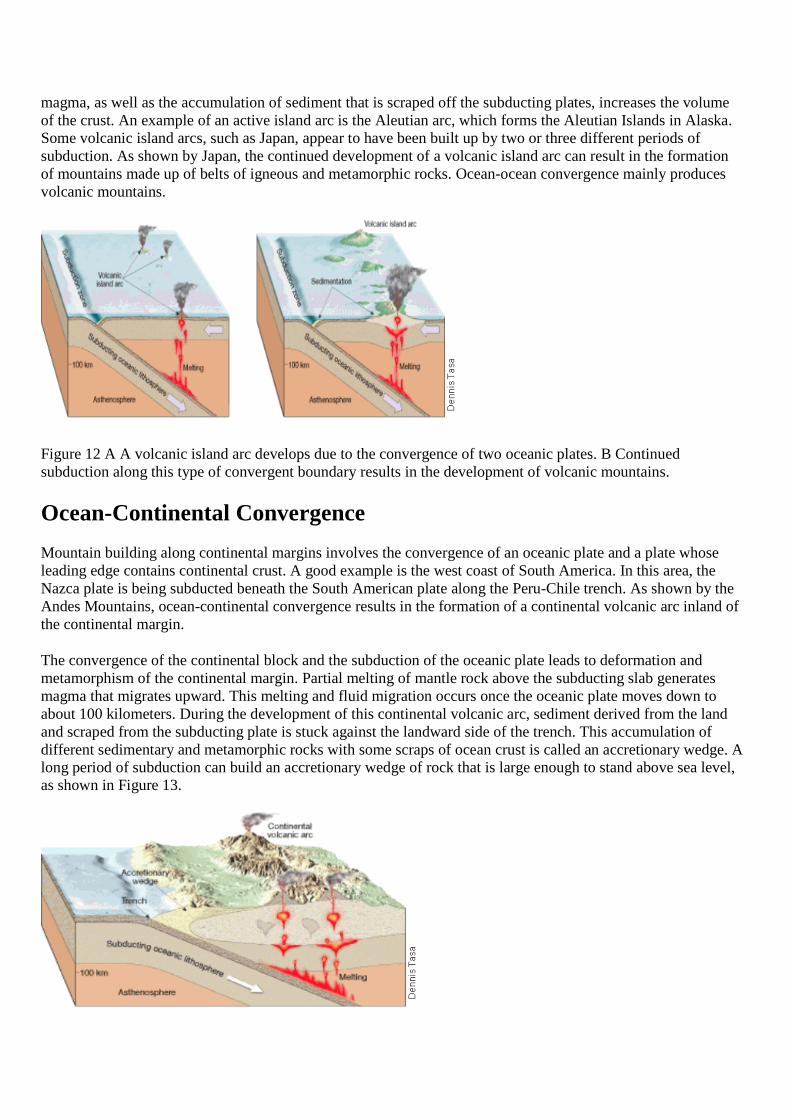
magma, as well as the accumulation of sediment that is scraped off the subducting plates, increases the volumeof the crust. An example of an active island arc is the Aleutian arc, which forms the Aleutian Islands in Alaska.Some volcanic island arcs, such as Japan, appear to have been built up by two or three different periods ofsubduction. As shown by Japan, the continued development of a volcanic island arc can result in the formationof mountains made up of belts of igneous and metamorphic rocks. Ocean-ocean convergence mainly producesvolcanic mountains.
Figure 12 A A volcanic island arc develops due to the convergence of two oceanic plates. B Continuedsubduction along this type of convergent boundary results in the development of volcanic mountains.
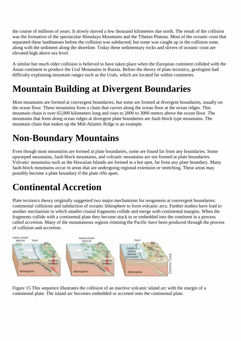
Ocean-Continental Convergence
Mountain building along continental margins involves the convergence of an oceanic plate and a plate whoseleading edge contains continental crust. A good example is the west coast of South America. In this area, theNazca plate is being subducted beneath the South American plate along the Peru-Chile trench. As shown by theAndes Mountains, ocean-continental convergence results in the formation of a continental volcanic arc inland ofthe continental margin.
The convergence of the continental block and the subduction of the oceanic plate leads to deformation andmetamorphism of the continental margin. Partial melting of mantle rock above the subducting slab generatesmagma that migrates upward. This melting and fluid migration occurs once the oceanic plate moves down toabout 100 kilometers. During the development of this continental volcanic arc, sediment derived from the landand scraped from the subducting plate is stuck against the landward side of the trench. This accumulation ofdifferent sedimentary and metamorphic rocks with some scraps of ocean crust is called an accretionary wedge. Along period of subduction can build an accretionary wedge of rock that is large enough to stand above sea level,as shown in Figure 13.

Figure 13 Ocean-Continental Convergence Plate convergence generates a subduction zone, and partial meltingproduces a continental volcanic arc. Continued convergence and igneous activity further deforms the crust andforms a roughly parallel folded mountain belt. Observing What type of mountains result from the partialmelting?
Ocean-continental convergence produces mountain ranges composed of two roughly parallel belts. Thecontinental volcanic arc develops on the continental block. The arc consists of volcanoes and large intrusivebodies mixed with high-temperature metamorphic rocks. The seaward belt is the accretionary wedge. It consistsof folded, faulted sedimentary and metamorphic rocks. The types of mountains formed by ocean-continentalconvergence are volcanic mountains and folded mountains.
Problem Solving
Rates of Mountain Building
The mighty Himalayas between India and Tibet are the tallest mountains on Earth, rising to more than 8kilometers. These mountains are still rising at about 1 centimeter per year. Mount Everest is the tallest peak withan elevation of 8848 meters above sea level. The Himalayas formed as a result of India colliding with theEurasian plate.
1. Calculating If you assume that the Himalayas will continue to be uplifted at the current rate of 1centimeter per year, how long will it take the mountains to rise another 500 meters?
2. Calculating Assuming a rate of uplift of 1 centimeter per year, how much higher could the Himalayas bein one million years?
3. Applying Concepts If the convergence of tectonic plates is causing the Himalayas to rise in elevation,what common surface processes are working to decrease their elevations?
4. Inferring Do you think it is reasonable for the Himalayas to continue to rise in elevation indefinitely?Explain your answer.
Continent-Continent Convergence
Continental crust floats too much to be subducted. At a convergent boundary between two plates carryingcontinental crust, a collision between the continental fragments will result and form folded mountains.
Figure 14 Continental- Continental Convergence The ongoing collision of India and Asia started about 45million years ago and produced the majestic Himalayas. A Converging plates generated a subduction zone,producing a continental volcanic arc. B Eventually the two landmasses collided, which deformed and elevatedthe mountain range.
An example of such a collision began about 45 million years ago when India collided with the Eurasian plate, asshown in Figure 14. Before this event, India was once part of Antarctica, and it had split from that continent over
the course of millions of years. It slowly moved a few thousand kilometers due north. The result of the collisionwas the formation of the spectacular Himalaya Mountains and the Tibetan Plateau. Most of the oceanic crust thatseparated these landmasses before the collision was subducted, but some was caught up in the collision zone,along with the sediment along the shoreline. Today these sedimentary rocks and slivers of oceanic crust areelevated high above sea level.
A similar but much older collision is believed to have taken place when the European continent collided with theAsian continent to produce the Ural Mountains in Russia. Before the theory of plate tectonics, geologists haddifficulty explaining mountain ranges such as the Urals, which are located far within continents.
Mountain Building at Divergent Boundaries
Most mountains are formed at convergent boundaries, but some are formed at divergent boundaries, usually onthe ocean floor. These mountains form a chain that curves along the ocean floor at the ocean ridges. Thismountain chain is over 65,000 kilometers long and rises to 2000 to 3000 meters above the ocean floor. Themountains that form along ocean ridges at divergent plate boundaries are fault-block type mountains. Themountain chain that makes up the Mid-Atlantic Ridge is an example.
Non-Boundary MountainsEven though most mountains are formed at plate boundaries, some are found far from any boundaries. Someupwarped mountains, fault-block mountains, and volcanic mountains are not formed at plate boundaries.Volcanic mountains such as the Hawaiian Islands are formed at a hot spot, far from any plate boundary. Manyfault-block mountains occur in areas that are undergoing regional extension or stretching. These areas maypossibly become a plate boundary if the plate rifts apart.
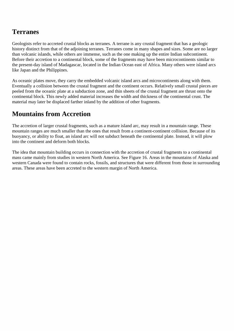
Continental AccretionPlate tectonics theory originally suggested two major mechanisms for orogenesis at convergent boundaries:continental collisions and subduction of oceanic lithosphere to form volcanic arcs. Further studies have lead toanother mechanism in which smaller crustal fragments collide and merge with continental margins. When thefragments collide with a continental plate they become stuck to or embedded into the continent in a processcalled accretion. Many of the mountainous regions rimming the Pacific have been produced through the processof collision and accretion.
Figure 15 This sequence illustrates the collision of an inactive volcanic island arc with the margin of acontinental plate. The island arc becomes embedded or accreted onto the continental plate.
Terranes
Geologists refer to accreted crustal blocks as terranes. A terrane is any crustal fragment that has a geologichistory distinct from that of the adjoining terranes. Terranes come in many shapes and sizes. Some are no largerthan volcanic islands, while others are immense, such as the one making up the entire Indian subcontinent.Before their accretion to a continental block, some of the fragments may have been microcontinents similar tothe present-day island of Madagascar, located in the Indian Ocean east of Africa. Many others were island arcslike Japan and the Philippines.
As oceanic plates move, they carry the embedded volcanic island arcs and microcontinents along with them.Eventually a collision between the crustal fragment and the continent occurs. Relatively small crustal pieces arepeeled from the oceanic plate at a subduction zone, and thin sheets of the crustal fragment are thrust onto thecontinental block. This newly added material increases the width and thickness of the continental crust. Thematerial may later be displaced farther inland by the addition of other fragments.
Mountains from Accretion
The accretion of larger crustal fragments, such as a mature island arc, may result in a mountain range. Thesemountain ranges are much smaller than the ones that result from a continent-continent collision. Because of itsbuoyancy, or ability to float, an island arc will not subduct beneath the continental plate. Instead, it will plowinto the continent and deform both blocks.
The idea that mountain building occurs in connection with the accretion of crustal fragments to a continentalmass came mainly from studies in western North America. See Figure 16. Areas in the mountains of Alaska andwestern Canada were found to contain rocks, fossils, and structures that were different from those in surroundingareas. These areas have been accreted to the western margin of North America.
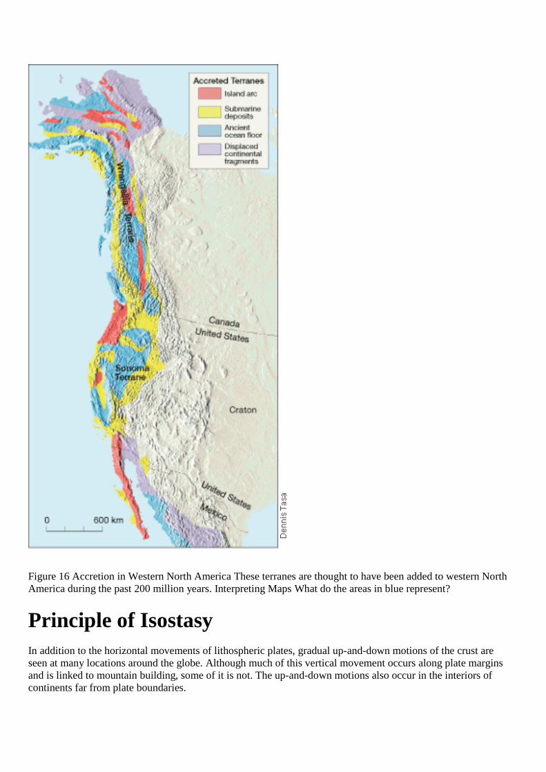
Figure 16 Accretion in Western North America These terranes are thought to have been added to western NorthAmerica during the past 200 million years. Interpreting Maps What do the areas in blue represent?
Principle of Isostasy
In addition to the horizontal movements of lithospheric plates, gradual up-and-down motions of the crust areseen at many locations around the globe. Although much of this vertical movement occurs along plate marginsand is linked to mountain building, some of it is not. The up-and-down motions also occur in the interiors ofcontinents far from plate boundaries.
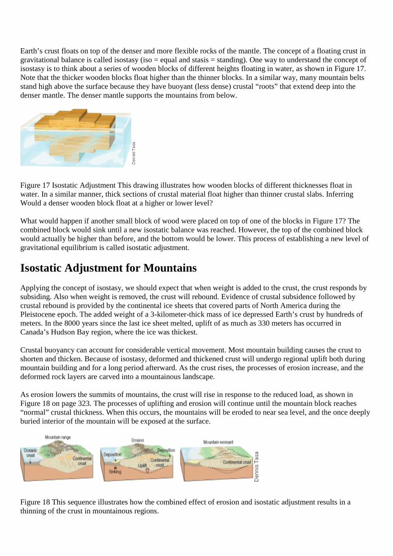
Earth’s crust floats on top of the denser and more flexible rocks of the mantle. The concept of a floating crust ingravitational balance is called isostasy (iso = equal and stasis = standing). One way to understand the concept ofisostasy is to think about a series of wooden blocks of different heights floating in water, as shown in Figure 17.Note that the thicker wooden blocks float higher than the thinner blocks. In a similar way, many mountain beltsstand high above the surface because they have buoyant (less dense) crustal “roots” that extend deep into thedenser mantle. The denser mantle supports the mountains from below.
Figure 17 Isostatic Adjustment This drawing illustrates how wooden blocks of different thicknesses float inwater. In a similar manner, thick sections of crustal material float higher than thinner crustal slabs. InferringWould a denser wooden block float at a higher or lower level?
What would happen if another small block of wood were placed on top of one of the blocks in Figure 17? Thecombined block would sink until a new isostatic balance was reached. However, the top of the combined blockwould actually be higher than before, and the bottom would be lower. This process of establishing a new level ofgravitational equilibrium is called isostatic adjustment.
Isostatic Adjustment for Mountains
Applying the concept of isostasy, we should expect that when weight is added to the crust, the crust responds bysubsiding. Also when weight is removed, the crust will rebound. Evidence of crustal subsidence followed bycrustal rebound is provided by the continental ice sheets that covered parts of North America during thePleistocene epoch. The added weight of a 3-kilometer-thick mass of ice depressed Earth’s crust by hundreds ofmeters. In the 8000 years since the last ice sheet melted, uplift of as much as 330 meters has occurred inCanada’s Hudson Bay region, where the ice was thickest.
Crustal buoyancy can account for considerable vertical movement. Most mountain building causes the crust toshorten and thicken. Because of isostasy, deformed and thickened crust will undergo regional uplift both duringmountain building and for a long period afterward. As the crust rises, the processes of erosion increase, and thedeformed rock layers are carved into a mountainous landscape.
As erosion lowers the summits of mountains, the crust will rise in response to the reduced load, as shown inFigure 18 on page 323. The processes of uplifting and erosion will continue until the mountain block reaches“normal” crustal thickness. When this occurs, the mountains will be eroded to near sea level, and the once deeplyburied interior of the mountain will be exposed at the surface.
Figure 18 This sequence illustrates how the combined effect of erosion and isostatic adjustment results in athinning of the crust in mountainous regions.