Embed Size (px)
Citation preview
Suburbanisation and Urban Growth: Revisiting the Life
Cycle Hypothesis
Kostas Rontos1, Christos Mavroudis2, Luca Salvati3
1 Department of Sociology, University of the Aegean, GR‐81100 Mitilini, Lesvos, Greece.
2 Greek National Statistical Authority, Pireos 46 & Eponiton, GR‐18510 Mitilini, Lesvos, Greece.
3 Council for Research in Agriculture – Centre for Soil‐Plant Relationships (CRA‐RPS), Via della
Navicella 2‐4, I‐00184 Rome, Italy
Running Title: Suburbanization in Athens, Greece.
Correspondence to:
Dr. Luca Salvati, Ph.D.
CRA‐RPS
Via della Navicella 2‐4
I‐00184 Rome, Italy
Fax: +39 6 700.57.11
E‐mail: [email protected]
Suburbanisation and Urban Growth: Revisiting the Life
Cycle Hypothesis
Abstract
This article illustrates the recent phases characterizing the urban development in
Athens in combination with the development of the Greek economy after the
second world war II era, in the light of the theory of spatial cycle. Since the
beginning of the post‐war period (1951‐1981), greater Athens has been going
through massive urban growth. Recently (1981‐2011) the investigated area has
shifted from relative to absolute decentralization, facing depopulation,
unemployment, and economic depression. Since differences among western,
southern and northern suburbs are important to explain the spatial pattern in
urban growth, a municipal scale analysis was carried out in order to identify the
direction of urban evolution through time. The recent decline in suburb’s growth
together with the emergence of urban centers outside greater Athens, provides
some evidence that the investigated area is towards disurbanization.
Key words: Suburbanization, Reurbanization, Urban gradient, Municipalities,
Mediterranean city.
Introduction
The high level of urbanization observed globally is a relatively recent
phenomenon. As a matter of fact, at the end of the 19th century the extension of
the world urbanization was rather limited. According to Weber (1899) only
Britain, western Europe and the USA population were classified for more than
25% as urban. The increasing levels of urbanization is the result of population
growth and rural‐to‐urban migration. The two major processes reinforce each
other, although their relative importance varies. As an example, Findley (1993),
found that, for 24 developing countries, the average contribution of migration to
urban growth was only 54% between 1975 and 1990, but other studies attribute an
increasing role of migration in the demographic expansion of urban regions.
However, according to many studies, such as Fielding (1982), Champion (1989),
and Cross (1990), indicators of urbanization should not be taken to mean that
urbanization is a unidirectional (low to high) process. In advanced countries the
level of urbanization stopped increasing between 1965 and 1990 and this
phenomenon is now acknowledged to indicate a process of population
redistribution at the regional scale.
The Theory of Spatial Cycle (SCT), introduced by Klaassen et al (1981) and firstly
adopted by Van den Berg et al. (1982), aims to explain the different stages of
urban development with a regional‐wide perspective. A cycle defines the time
period during which a demographic phase at a defined spatial unit (i.e. an urban
region) emerges and declines, while a transition is the time period between two
cycles. A cycle is based upon the fact that a system, once in place, works
according to a relative stability of its parameters and their dynamics in time and
space (Rodrigue et al. 1997). According to SCT, the development of an urban
region may be described using four phases:
(i) the urbanization phase, when certain settlements grow at the cost of their
surrounding countryside,
(ii) the suburbanization (or ex‐urbanization) phase, when the urban ring
(commuter belt) grows at the cost of urban core,
(iii) the dis‐urbanization (or counter‐urbanisation) phase, when the population
loss in the urban core exceeds the population gain in the ring, resulting in overall
population decline,
(iv) the re‐urbanisation phase, when the core city starts re‐attracting population
while the suburbs still experience demographic decline.
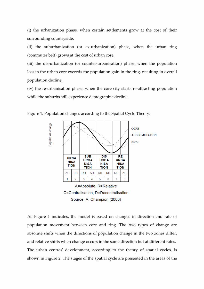
Figure 1. Population changes according to the Spatial Cycle Theory.
As Figure 1 indicates, the model is based on changes in direction and rate of
population movement between core and ring. The two types of change are
absolute shifts when the directions of population change in the two zones differ,
and relative shifts when change occurs in the same direction but at different rates.
The urban centresʹ development, according to the theory of spatial cycles, is
shown in Figure 2. The stages of the spatial cycle are presented in the areas of the
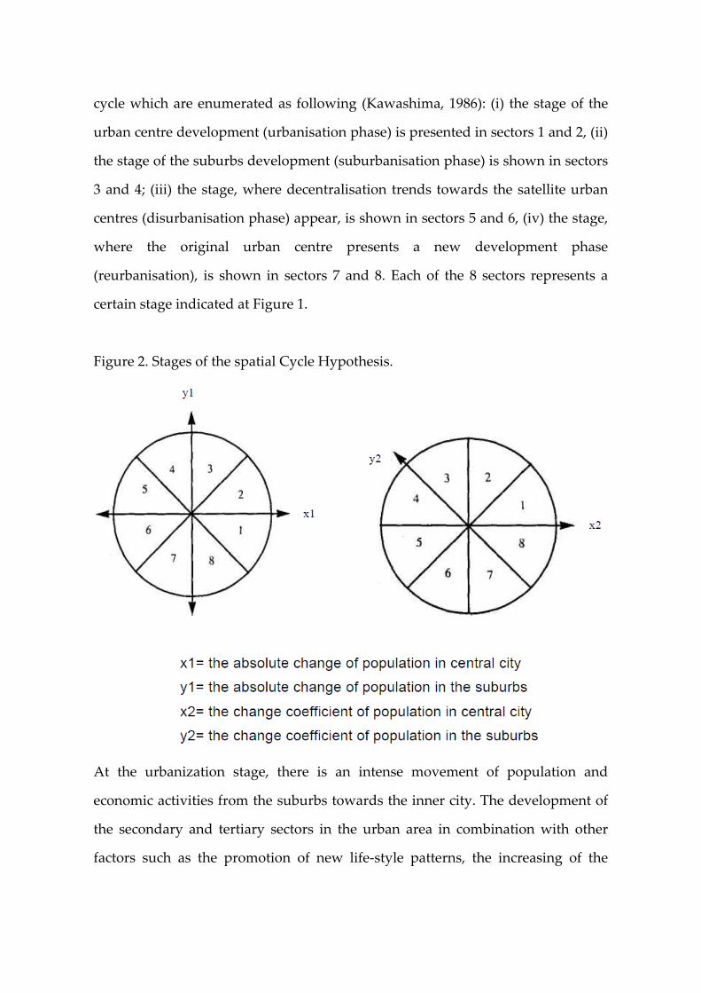
cycle which are enumerated as following (Kawashima, 1986): (i) the stage of the
urban centre development (urbanisation phase) is presented in sectors 1 and 2, (ii)
the stage of the suburbs development (suburbanisation phase) is shown in sectors
3 and 4; (iii) the stage, where decentralisation trends towards the satellite urban
centres (disurbanisation phase) appear, is shown in sectors 5 and 6, (iv) the stage,
where the original urban centre presents a new development phase
(reurbanisation), is shown in sectors 7 and 8. Each of the 8 sectors represents a
certain stage indicated at Figure 1.
Figure 2. Stages of the spatial Cycle Hypothesis.
At the urbanization stage, there is an intense movement of population and
economic activities from the suburbs towards the inner city. The development of
the secondary and tertiary sectors in the urban area in combination with other
factors such as the promotion of new life‐style patterns, the increasing of the
financial and institutional power of metropolis, the infrastructural development,
creates the proper conditions for urbanization.
With the growth of resident population and economic activities within the city
centre, the negative external economies of urbanization (traffic, pollution, crimes,
poverty) are getting importance. Households of medium‐ and especially high‐
income thus move to the suburbs with high environmental quality and favorable
conditions of housing. Thus, suburbanization, the second phase of the spatial
cycle, emerges. According to Bourne (1996), suburbs were interpreted in various
ways: (i) as a mechanism to escape social and environmental problems common
in the central city, (ii) as a macro‐economic policy tool for generating local
employment and promoting capital accumulation, (iii) as a means of individual
utility maximization, (iv) as a means of socio‐political strategies assuring social
homogeneity, recapturing an assumed‐rural way of life, without completely
losing the advantage of urban living.
As an example, suburbanization in Germany was slowly but continuously
increasing everywhere since the last fifty years (Mäding 2004). The degree of
suburbanisation of the population was greater than that of employment. In the
1960s and 1970s commuter distances increased. In the 1980s and 1990s inter‐
regional migration and the establishment of companies progressively
strengthened the suburban areas. Settlement axes were grown according the
extension of road and railway network while ‘employment suburbanisation’ was
concentrated in places with transportation facilities. Shopping and leisure
facilities areas were appearing to a great extent in surrounding areas, which were
easily reached by car. Even surprising ʺspatialʺ connections were found e.g., those
who lived to the south of an inner city, often moved to a southern suburb in the
same urban region.
The suburbanisation wave reaches its greatest extension in the phenomenon of
massive ex‐urbanisation. In the USA, Nelson (1992) identified four principal
factors to explain ex‐urbanisation: (i) continued deconcentration of employment
at the rise of exurban industrialization; (ii) the latent anti‐urban and rural location
preferences of US households, (iii) improved technology that makes exurban
living possible and finally, (iv) an apparent policy bias favoring exurban
development over compact development.
Exurbia tend to be dominated by middle‐class residents, many of whom commute
long distances to work in city or in the newer suburbs, but other groups are also
present, including retirees and young households seeking social status, free land
and new housing at a lower cost than it was available in the suburbs. Davis et al.
(1994) found that in the USA, exurban development has captured as much as 25%
of recent country population growth and 60% of recent manufacturing
investment. For this heralds a ʹpost‐suburbanʹ era characterized by inner
suburban population loss and relative income decline, an increase in suburban
employment, a reduction in population and income, and increased farmland
conversion to urban use (Lucy and Philips, 1997).
With the re‐establishment of companies and the over‐concentration of population
into the suburbs, the previous stage is completed and the disurbanisation stage
begins. Households and businesses have vacated a big part of the centre of the
metropolis. This evolution has two consequences: in the core city, the economical
activity is shrunk and the abandoned spaces are occupied by marginal social
groups. In 2000 the 50% of the USA population leave at the suburbs. According to
Gareau (1988), the functions of the suburbs range from undifferentiated
residential areas to a more recent mix. This mix includes specialized retail
corridors, high‐technology industrial clusters, and high‐density office and
commercial nodes or “edge cities”. These consequences mainly result into the
gentrification of the inner city.
According to Mäding (2004), the negative external effects have an impact on
public property and social objectives are endangered. This will be explained
briefly with regard to the attitude of high‐ and middle‐class households to leave
the inner cities and look for areas of preferential single family housing.
Population growth, changes in household structure, income growth and the
higher demand for housing resulting from it, increase the demand for settlement
areas progressively further away from the core cities.
All these factors result in the disurbanisation stage. This stage is completed by the
appearance of adverse conditions in saturated suburbs and the movement of
households in new cities or settlements of high environmental quality and better
standards of living. According to Pacione (2005), signs of a population reversal in
rural areas were first identified in the USA, but similar trends were soon detected
in other advanced nations, including Canada, Australia, Western Europe and
Britain. Counterurbanisation in United Kingdom started since the early 1960s
when for the first time areas located further away from the urban influence began
to grow faster than the main conurbations and their dependent regions.
Population growth in rural Britain was particularly strong in the late 1960s and
early 1970s but has continued over recent decades, with net out‐migration from
the main metropolitan areas to the rest of the country averaging 90,000 people per
year with a rate of 0.5%. The reasons for this reversal of long established trends
are multifaceted and site‐specific and any attempt to apply a unique explanation
to so widely diverse changes in different regions would result simplistic.
Findings from a range of studies provide an useful inventory of contributory
factors to the Life Cycle Theory. These include: (i) continuing growth of
metropolitan centers and their spillover into adjacent non‐metropolitan counties,
(ii) decentralisation of manufacturing in pursuit of lower land and waste costs,
(iii) increased pursuit of leisure activities at all ages, (iv) narrowing the traditional
gap between rural and urban lifestyles with extension of access to modern
facilities, (v) more long‐distance commuting and lower cost of living in rural
areas, (vi) residential preference for lower density rural living and finally, (vii)
government decentralisation policies.
The extension to which each factor contributes to population change will depend
on local conditions. Theoretically, there is a last phase (reurbanisation) where the
core city shows a more slight decrease in population; in parallel, gentrification,
which was observed in the previous phase start to disappear (Lever, 1993). The
ability of ameliorating the housing conditions of the core city, where some old
houses are demolished and restored, constitutes a primary factor of the above
mentioned evolution. In the later period of this phase, the population living in the
inner city increases again while suburbsʹ population decreases. In some cases,
households start moving from the suburbs to the centre. Changes in the economic
structure of the urban region are additional factors driving this phase. The
development of high‐technology tertiary sector as well as changes in the cost of
energy and transportation, bring the economic activity back to the centre of the
city (Lever, 1993).
However, the empirical evidence for reurbanisation is mixed. Cheshire (1995)
found that in 241 functional urban regions (FURs) in Europe between 1981 and
1991 the proportion of urban cores gaining population reached 47%, compared
with, only 22% over the period 1975‐81. However, it was mainly the smaller FURs
that exhibited reurbanisation, not the larger, older urban regions. In the UK
reurbanisation occurred in only four of 36 FURs (Glasgow, Oxford, Cambridge
and Canterbury), with only Glasgow confirming model expectations.
On the other hand, there is a growing body of case‐study evidence that indicates a
recovery of large cities since the 1970s. In the USA, the 1980s witnessed the re‐
emergence of the larger metropolitan areas as the fastest growing elements of the
economic system. Overall, metropolitan areas with 1 million or more residents
grew by 12% in the 1980s compared with 8% in the previous decade.
According to Pacione (2005), the population growth that has occurred in the
central areas of US cities was fuelled by two distinct migration streams. First, new
migrants, primarily from Latin America and Asia, moved into lower‐value areas
of cities such as New York and Los Angeles, as well as into other metropolitan
areas on the west coast (San Diego and San Francisco), in the South‐West
(Houston) and Florida (Miami) that historically had attracted relatively fewer
migrants. The second stream comprised a flow of ʹbaby‐boomersʹ (those born just
after the Second World War and during the 1950s and 1960s) investing in high‐
status residential areas. During the 1980s the strongest magnets for adult
ʹboomersʹ were metropolitan areas with expanding high‐tech and defence‐
oriented economies, including coastal cities such as Boston and Seattle and
sunbelt locations like Dallas and Atlanta. Australia and Canada also provide
evidence of strengthening metropolitan areas and inner‐city growth in the 1980s.
In general, the empirical observations of Pacione (2005) suggest that there are
widespread signs of renewed growth or reduced population decline for larger
metropolitan areas, as well as a population recovery for some cores cities, and
there is also a disagreement over the extent to which the inner‐city revitalisation
that took place in the 1980s will be able to continue and lead to fundamental
changes in the form of developed urban regions.
The process of decentralisation, on the other hand, is likely to continue as a major
feature of post‐industrial urbanisation, though in a form very different from the
suburbanisation phase observed after the second World War. Baker et al. (2000)
replaced the model of inner and middle city decline and growth in the outer rings
with a more complex pattern in which the positive correlation between
population growth rate and distance from the city centre has been eroded. This is
partly due to demographic factors. It has been shown in Australian cities that in
the early post‐war years of rapid population growth whole suburbs tended to be
initially settled by young families with children. As these groups have aged and
their children left, the population declines.
However, as these original settlers die or move into aged care accommodation
their houses come onto the market and are purchased by younger people. This
often sees one occupant of a home replaced by two or three occupants causing
population growth. However, it is also clear that other elements are also at work.
On the one hand, local and state governments are encouraging urban
consolidation.
There are some elements in the population who are showing a preference for
urban‐type lifestyles. This has undoubtedly caused increased population growth
in inner and middle suburbs. On the other hand, suburban growth has certainly
not ceased especially in the fastest growing cities. So, in recent decades however
along with all the OECD nations, Australia has attempted to move toward more
ʺsustainableʺ compact cities by changing land‐use policy to encourage increases in
population density in built‐up areas.
The process of urbanisation at a local level was specified by Nordstrom who
studied the settlement pattern changes in all the development phases of a given
city. According to Nordstrom (1981), the settlement pattern of population and
activities is seriously affected by the economic development, the time of its
completion as well as the general social changes caused by it. He reported that,
when a society develops, all the activities which affect employment ‐ and
consequently the settlement pattern ‐ undergo changes which pass through
various developing phases. Also, he points out the impact of the environmental
conditions and the exercised policy function as basic parameters in the form of the
settlement pattern in modern societies. The impact of the latter factor is stressed in
other studies, too (Korcelli, 1986). At local level, the urban structure depends on
two variables: the available space per inhabitant and the total number of
inhabitants (Nordstrom, 1981).
In the frame of the empirical analysis of the urban centre development and
according to the theory of the spatial cycle, the usual variables can be the absolute
or relative change of population in the geographical units of interest (Kawashima,
1986; Korcelli, 1986) or their population density (Nordstrom, 1981; Schwizer, 1985;
Alperowitz, 1983). Regardless of the choice of variable or the analysis level of the
urban development, a systematic empirical implementation of the spatial cycle is
succeeded through the division of the city into districts or communes and
municipalities and then clustering according to their distance from a central point
of the core city. Next step consists of examining the development of these
clustered areas or communities within a given period of time.
In an implementation of this method, Nordstrom (1981) performed a zoning of
the city of Gothenburg according to parishes by clustering them according to their
distance from a central point. Then he studied the evolution of the population
density for these grouped parishes within a certain period of time (1910‐1975).
Kawashima (1986), in one of his studies about the development stages of the
Tokyo Metropolitan Area, divided it into zones of cities and villages according to
their distance from a central point of the city of Tokyo and studied the population
changes in these zones during the period 1960‐1985. The mean distance from the
centre of the core city is widely used as an indicator of suburbanization
(Mordridge and Parr, 1997).
The basic conclusion of the empirical applications, relative to the spatial cycle, for
a given zone, is that: the longer the distance from the central point is, the shorter it
appears the highest value of the variable used (either density of population or
population change). In the present study the theory of the spatial cycle, based on
the techniques which are in accordance with the ones mentioned above, is applied
to a case study encompassing the Athens Metropolitan Area. New data derived
from the recent population censuses provide the relative evolutions in the greater
urban area in Greece during 1991‐2011. That is the reason why we believe that it is
worth studying again the spatial cycle approach in Athens Metropolitan Area.
Additionally, the recent empirical results worldwide that are reviewed above are
making the paper more informative. Next to this introduction, the methodology
and the implementation of the specific technique used are developed, while in the
following a discussion and some basic conclusions about the stages of the urban
evolution in Athens are provided.
Material and methods
The analysis covers the time period encompassing 1951‐2011. The study could not
be extended before 1951 because of the decade 1941‐1951, when the changes in the
settlement patterns were a result of other factors different from the ones matching
with the theory of the spatial cycle. Those radical changes in the population and
the economic relations resulted from exceptional external factors as a consequence
of the World War II and the following civil war in Greece. The time limitation
does not permit the use of the population density as a variable because, according
to the spatial cycle analysis, it is used in case of studying long‐term population
changes. The metropolitan region of Athens (AMA) was considered as the
investigated area. According to the administrative system enforced in law in
Greece, the AMA is divided into greater Athens (including both central city and
suburbs) and the rest of the Attica region. To this region belongs some towns and
villages more or less economically independent from the core city of Athens.
Results
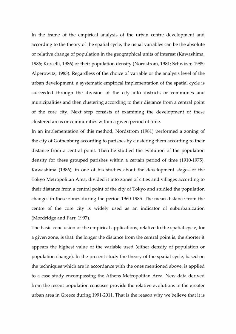
Based on the circular diagram of the spatial cycle, we initially study the
population changes in the investigated area during the period 1951‐2001. X‐axis
counts the absolute difference of the Athens city population and the Y‐axis counts
the absolute difference of the suburbs population during the censuses interval. In
Figure 3 the points A, B, and C (referring to the decades 1951‐1961, 1961‐1971 and
1971‐1981) are placed within the third class of the cycle; this fact implies that,
during period 1951‐1981, the AMA was at the development phase of suburbs
around the core city of Athens (suburbanisation phase) and particularly at the
stage 3, the so called stage of relative suburbanisation where both core and
suburbs populations are increasing.
During 1981‐1991, the population path (city of Athens change ● the suburbs
change) shifts to point D which is within the fourth class of the cycle. This
evolution means that, even at the phase of suburbanisation, the differentiation is
obvious: the population of the city of Athens decreases while the population of
the suburbs increases slowly. In fact the AMA had passed to the stage of absolute
suburbanisation. The urban centre as a whole (core and suburbs), however,
continued to gain population. In 1991‐2001, point E was stable in stage 4 but was
changing direction closing towards class 3 again.
Figure 3. The Spatial Life Cycle diagram applied to Athens metropolitan area.
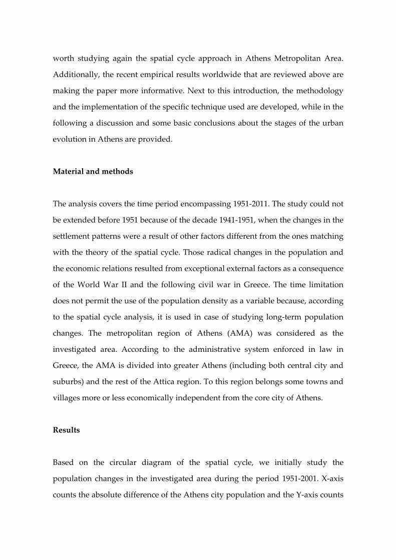
Next, we performed a classification of the Attica municipalities and communes
into zones set up according to their distance from a central place in Athens
(Syntagma Square: Figure 4). The aim is to examine the population variation in
these distance zones and through these results, the time definition of the stages of
the spatial cycle. It must be pointed out that the specific analysis is expanded to
the whole AMA, which includes not only the greater Athens (core city and
suburbs) but also the rest of Attica.
Figure 4. Classification of the municipalities in AMA according to the distance
from the centre of Athens.
In Table 1, the population evolution of the municipalities and communes of the
Attica Region was shown according to distance zones and years. Figure 5
illustrates the population change rates by distance zone and year. The resulting
data provide indications about the metropolitan development in the biggest
urban area of Greece.
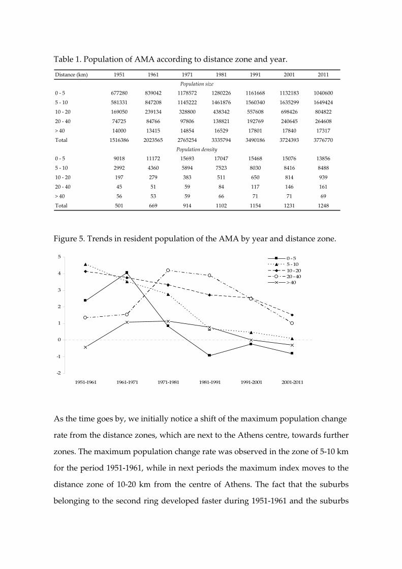
Table 1. Population of AMA according to distance zone and year.
Distance (km) 1951 1961 1971 1981 1991 2001 2011
0 ‐ 5 677280 839042 1178572 1280226 1161668 1132183 1040600
5 ‐ 10 581331 847208 1145222 1461876 1560340 1635299 1649424
10 ‐ 20 169050 239134 328800 438342 557608 698426 804822
20 ‐ 40 74725 84766 97806 138821 192769 240645 264608
> 40 14000 13415 14854 16529 17801 17840 17317
Total 1516386 2023565 2765254 3335794 3490186 3724393 3776770
0 ‐ 5 9018 11172 15693 17047 15468 15076 13856
5 ‐ 10 2992 4360 5894 7523 8030 8416 8488
10 ‐ 20 197 279 383 511 650 814 939
20 ‐ 40 45 51 59 84 117 146 161
> 40 56 53 59 66 71 71 69
Total 501 669 914 1102 1154 1231 1248
Population density
Population size
Figure 5. Trends in resident population of the AMA by year and distance zone.
‐2
‐1
0
1
2
3
4
5
1951‐1961 1961‐1971 1971‐1981 1981‐1991 1991‐2001 2001‐2011
0 ‐ 55 ‐ 1010 ‐ 2020 ‐ 40> 40
As the time goes by, we initially notice a shift of the maximum population change
rate from the distance zones, which are next to the Athens centre, towards further
zones. The maximum population change rate was observed in the zone of 5‐10 km
for the period 1951‐1961, while in next periods the maximum index moves to the
distance zone of 10‐20 km from the centre of Athens. The fact that the suburbs
belonging to the second ring developed faster during 1951‐1961 and the suburbs
of the third zone developed faster in the following periods, confirms the previous
analysis according to which, the AMA went through the stage of the suburbs
development in 1951‐1981. Nevertheless, we must note that the furthest distance
zones showed a remarkable increase in population rates since 1971. The bigger
the distance of the given zone from the central city of the given metropolitan area
is, the later it reaches the maximum value (peak) of its population change and this
result is in accordance with the initial hypothesis.
The appearance of the maximum change value of the Athens population and its
closer suburbs during period 1961‐1971 could possibly be attributed to an
irregularity which occurred from the huge inflow of immigrants in the region of
Athens. An irregularity is also appeared in the more distant zones, where the
peak is coming back to the period 1971‐1981.
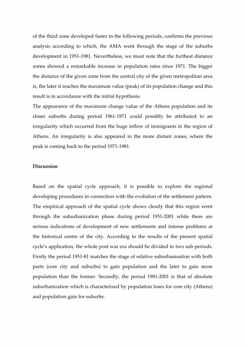
Discussion
Based on the spatial cycle approach, it is possible to explore the regional
developing procedures in connection with the evolution of the settlement pattern.
The empirical approach of the spatial cycle shows clearly that this region went
through the suburbanization phase during period 1951‐2001 while there are
serious indications of development of new settlements and intense problems at
the historical centre of the city. According to the results of the present spatial
cycle’s application, the whole post war era should be divided in two sub‐periods.
Firstly the period 1951‐81 matches the stage of relative suburbanisation with both
parts (core city and suburbs) to gain population and the later to gain more
population than the former. Secondly, the period 1981‐2001 is that of absolute
suburbanization which is characterized by population loses for core city (Athens)
and population gain for suburbs.
The population in the suburbs of Athens city presents a bigger growth in relation
of Athens population during the whole post‐war era. It is characteristic that the
increasing rates of the population in Athens city were close to zero during period
1951‐1961; this trend was reversed during pe riod 1961‐71 while the zero increase
rates came back in the decade 1971‐1981. Within the decade 1981‐1991, the
population of Athens city decreased. A weak decrease was observed for the
decade 1991‐2001 (only 1%).
The impact of intense population changes, during 1941‐51, explains to a certain
degree the irregular behaviour at the beginning of the post‐war period. When
Greece returned to the normal developing procedures of peace period, the
evolution of the population changes in Athens and its suburbs came back to a
normal tempo and the suburbs present obviously faster population increase rates.
The huge accumulation of emigrants from the provinces to the capital during
period 1961‐71, leads quickly ‐ and maybe prematurely ‐ to the over concentration
of population and activities in the city of Athens; as a consequence, a respectively
big part of its new inhabitants was led to the suburbs‐mainly in the Departments
of Western Attica and Piraeus (Rontos, 1987). At the same time, the degradation
of the life quality at the core city led part of the inhabitants, mainly of high
income, to the northern and eastern suburbs within decade 1961‐1971.
The later reason of movement becomes obvious from the big population change
rates in the north‐eastern suburbs which attracted the high‐income inhabitants,
like the municipalities of Kifissia, Amaroussio, Filothei, and Psychiko. We make
the assumption of the high‐income inhabitant movements in the intraregional
level taking in account that it is rather impossible to have a remarkable
population increase in expensive suburbs that could be justified form the flow of
low‐ and medium‐income immigrants, originating from the rest of the country.
During 1961‐1971 negative external economies appear and they become even
more obvious within next period 1971‐1981. We should mention that Athens city
population almost stagnates during the decade 1971‐1981 while the population of
suburbs increased by the same absolute number as the ones in previous periods.
The population movement from Athens to the suburbs played an important,
determining factor in the change of settlement patterns within decade 1971‐1981
since the impact of immigrantsʹ flow was much lower compared to previous years
(Rontos, 1987).
During 1976‐1980, the inter‐municipality demographic movements within the
AMA reach approximately 250,000 inhabitants. Within the decade 1971‐1981, the
overpopulated – even saturated ‐ city of Athens led the immigrants from the rest
of the country to settle in the Athens suburbs. In addition, we should point out
the accumulation of the public and private sectorsʹ services in central areas of the
city of Athens which functioned competitively to the housing needs and
concurred to the movement of inhabitants towards the suburbs.
The centralized administrative system and the necessity to satisfy the need of
services for a continuously increased population pushed the population to settle
in the suburbs. The relation of environmental conditions to this change of pattern
‐ from the city of Athens to the suburbs ‐ has not been analyzed empirically but it
must have played an important role in the decade 1981‐1991.
However the last decade 1991‐2001 presents an interesting situation leading to
two different scenarios for the future. Initially AMA, remains at the absolute
suburbanization stage (quadrant 4 of Figure 3). As a result an advance to the next
stage of disurbanisation phase (5th or 6th stage) does not seem to occur. On the
contrary, the Cartesian product approaches again stage 3. During 1991‐2001 we
observe a slow down of centre Athens population decrement in relation with
1981‐1991. For the suburbs we observe that the excessive deceleration of
population increase during 1981‐1991 in relation with the previous periods
(transition from points A, B, C to point D) during the last period present a
stabilization of the population growth rate (from point D to E).
We can assume that if the increased deceleration of suburban population
continues in conjunction with the centre population variation we should advance
to stage 5. In case of a decrease of suburbs population we could advance to stage 6
or 7. The reason of this irregularity can be likely attributed to the foreign
emigrants who definitively boost the Athens centre population. Rehabilitation
and return of local population from the suburbs does not seem probable. A heavy
concentration of foreign population in Athens (74% of Attica foreign population
and 36% of Greece) can however influence the rehabilitation of the inner city.
Foreign emigrants choose to settle in Athens centre because of cheaper house
rents, easier transportation, shared residence with other migrants from the same
country, benefits provided by the state or local organizations, and rallying.
During 1991‐2001 we faced a similar situation with the 1961‐1971 when the
excessive internal immigration had caused irregularities to the spatial cycle
evolution, as it is already mentioned above.
According to the obtained results, we can illustrate two possible scenarios for the
future evolution of AMA: (i) if the Athens centre rehabilitation is temporary and
in the future is discontinued (that means acceleration of core population decrease
in combination with a deceleration of suburbs population increase) we will
advance at stage 5 (absolute disurbanisation); (ii) if the suburbs population
decreases we will advance at stage 6 or 7 (relative disurbanisation or relative
reurbanisation stage). 2. In case the centre of Athens (core city) presents a
population increase (continues the recent tendency) combined with a population
decrease in suburbs we will advance at stage 8 (absolute reurbanisation stage).
Further research, including future population projections of cities and villages in
AMA and intra‐suburbs analysis, should be undertaken in order to gather new
evidences for the future evolution of large Mediterranean cities.
References
G. Aplerovich (1983) “An empirical study of population, density gradients and
their determinants”, Journal of Regional Science. 23, p.p. 529‐540.
E. Baker, N. Coffee and G. Hugo (2000) “Suburbanisation Vs Reurbanisation:
Population Distribution Changes in Australian Cities” Department of the
Environment and Heritage, Canberra
M. Batty and Karmeshu (1983) “A Strategy for Generating and Testing Models of
Migration and Urban Growth”, Reg. Studies. 17, pp. 223‐236
L. van de Berg, R. Drewett, L. Klaassen, L. Rossi and C. Vijverberg (1982): “A
Study of Growth and Decline”, Oxford
L. Bourne (1996): “Reinventing the suburbs: old myths and new realities”,
Progress in Planning 4b(3), 163‐84
A. Champion (1990): “Counterurbanisation: The Changing Pace and Nature of
Population Decentralisation, London.
A. Champion (2000): “Urbanisation, suburbanisation, counterurbinisation and
reurbanisation”, in R. Paddison and W. Lever “Handbook of Urban Studies”
London
P. Cheshire (1995): “A new phase of urban development in Western Europe?”
Urban Studies, 32
D. Cross (1990): “Counterurbanisation in England and Wales” Aldershot
J.S. Davis et al. (1994): “The new ‘burbs: The exurbs and their implications in
planning policies” Journal of the American Planning Association, 60
A. Fielding (1982): “Counterurbanisation in Western Europe” at Progress in
Planning 17(1)
S. Findley (1993): “The third world city: development policy and issues” in J.
Kasarda and A. Parnel “Third world Cities”, London
W. H. Frey (1983) “A Multiregional population‐projection framework that
incorporates both migration and residential mobility streams: application to
metropolitan city‐suburb redistribution”, Environment and Planning A. 15, pp.
1613‐1632
W.H. Frey (1990) “Metropolitan America: beyond the transition”, Population
Bulletin 45, pp. 1‐51.
J. Garreau (1988): “Edge city” New York
P. Hall (1997) “The future of the metropolis and its form” Regional Studies. 31,
pp. 211‐220.
T. Kawashima (1986) “Spatial cycle hypothesis and Roxy index method:
implications of the 1985 population census figures for the stage of
suburbanization of Tokyo Metropolitan area”. A paper prepared for the RSA
twenty Sixth European Congress, Krakow, Poland.
H. Kingsley and W. Enders (1975) “Distance, Direction and Entropy in the
Evolution of a Settlement Pattern”, Economic Geography. 51, pp. 357‐365.
L. H. Klaassen (1981): “Transport and re‐urbanisation”. Gower Publishing
Company, Hants, England
L. Klaassen, W. Molle and J. Paelinck (1981): “Dynamics of Urban Development”
New York
P. Korcelli (1986): “Growth rate fluctuations and alternative trajectories of future
populations change: A case of Warsaw region”, paper prepared for the RSA
twenty Sixth European Congress, Krakow, Poland.
M. Law (1988) “The Uncertain Future of the Urban Core”, London, Routledge.
W. F. Lever (1993): “Reurbanisation ‐ The policy implications”. Urban studies 30,
pp. 267‐284.
W. Lucy and C. Philips (1997): “The post‐suburban era comes to Richmond: city
decline, suburban transition, and exurban growth” Landscape and Urban
Planning, 36
H. Mäding (2004): “Suburbanisation and Urban Development in Germany.
Trends ‐ Models – Strategies” Deutsches Institut für Urbanistik
F. Masser and D. Stroud (1965): “The Metropolitan Village” Town Planning
Review, 36.
M. Mordridge and J. Parr (1997): “Metropolis or region: On the development and
structure of London”. Regional Studies 31, pp. 97‐115.
A. Nelson (1992): “Characterizing exurbia ”Journal of Planning Literature, 5, 350‐
368
L. Noordstrom (1981): “Population changes in a functional regional system”.
Economic Geography, 57, pp. 183‐198
M. Pacione (2005): “Urban Geography”, 2nd edition, Abingdon, UK
Jean‐Paul Rodrigue, Brian Slack and Claude Comtois (1997): “Transportation and
spatial cycles: Evidence from maritime” Journal of Transport Geography, 5(2), 87‐
98
K. Rontos and A. Papadaskalopoulos (1994) “The Approach of Spatial Cycle: The
Case of the Athens Metropolitan Area 1951‐1991”, Journal of Greek Official
Statisticians, 30(1‐2).
V. Schwitzer (1985) “Fiscal Independence, Spillovers and Residential Choice”,
Regional Science Association, 56, 59‐70.
A.F. Weber (1899) “The growth of cities in 19th century”, New York.