Embed Size (px)
Citation preview
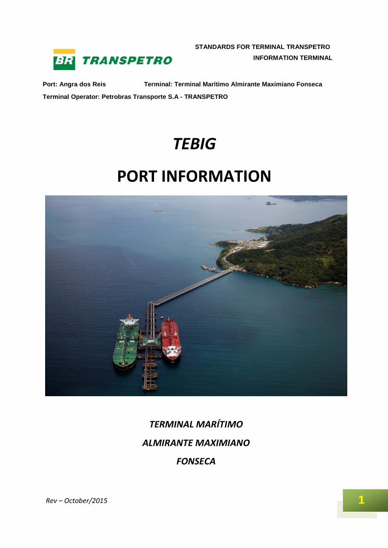
Port: Angra dos Reis Terminal: Terminal Marítimo Al mirante Maximiano Fonseca
Terminal Operator: Petrobras Transporte S.A - TRANS PETRO
1
STANDARDS FOR TERMINAL TRANSPETRO
INFORMATION TERMINAL
Rev – October/2015
TEBIG
PORT INFORMATION
TERMINAL MARÍTIMO
ALMIRANTE MAXIMIANO
FONSECA
Port: Angra dos Reis Terminal: Terminal Marítimo Al mirante Maximiano Fonseca
Terminal Operator: Petrobras Transporte S.A - TRANS PETRO
2
STANDARDS FOR TERMINAL TRANSPETRO
INFORMATION TERMINAL
Rev – October/2015
1 INTRODUCTION, p. 3 2 DEFINITIONS, p. 4 3 CHARTS AND REFERENCE DOCUMENTS, p. 4 4 DOCUMENTS AND INFORMATION EXCHANGE, p. 5 5 DESCRIPTION OF THE PORT AND ANCHORAGE AREA, p. 6 6 DESCRIPTION OF THE TERMINAL, p. 19 7 PROCEDURES, p. 23 8 PORT AND ACHORAGE AREA ORGANIZATION, p. 28 9 EMERGENCY PLAN, p. 31 10 CONTACTS, p. 35 APPENDICES, p. 37 A Location of the Tebig Pier, p. 37 B Towing scheme for ships below 100.000 DWT, p. 38 C Towing scheme for ships over 100.000 DWT and belo w 200.000 DWT, loaded, p. 43 D Towing scheme for ships over 200.000 DWT , p.48 E Diagram or each berth considering the lengths, de fenses, dolphins, location of mooring
points and manifolds, p. 52 F Diagram with loading connections, dimensions and sizes of flanges, p. 53 G Essential Information from the Ship to the Termin al, p. 54 H Information to be exchanged before cargo transfer , p. 55.

Port: Angra dos Reis Terminal: Terminal Marítimo Al mirante Maximiano Fonseca
Terminal Operator: Petrobras Transporte S.A - TRANS PETRO
3
STANDARDS FOR TERMINAL TRANSPETRO
INFORMATION TERMINAL
Rev – October/2015
1 INTRODUCTION This Port Information has been prepared by Petrobras Transporte S.A. TRANSPETRO, which Operates the TEBIG Terminal in the Port of Angra dos Reis. It provides essential information to the ships operating at the Terminal. This document is also distributed internally in the organization, and to the interested port parties, local and national authorities. The Port Information has versions in Portuguese and English languages. The information contained herein serves to supplement, but never to supersede or alter, any legislation, instructions, guidance or official publications, either national or international. Therefore, anything that conflicts with any of the aforementioned documents should be disregarded. The Terminal holds itself the right to change any of its operational features herein presented, with no advance notification. Where any information is found to be incorrect and requiring updating, please contact: Gerência do Terminal de Angra dos Reis Rodovia Governador Mário Covas, km 467 ZIP Code: 23916-000 – Angra dos Reis – RJ – Brazil Phone: (55 24) 3366-5201 Fax: (55 24) 3366-5390 Petrobras Transporte S.A. – Transpetro Avenida Presidente Vargas, 328 ZIP Code: 20.091-060 – Rio de Janeiro – RJ – Brazil Phone: (55 21) 3211-9085 Fax: (55 21) 3211-9067 The most recent version of this Port Information can be obtained at www.transpetro.com.br
Port: Angra dos Reis Terminal: Terminal Marítimo Al mirante Maximiano Fonseca
Terminal Operator: Petrobras Transporte S.A - TRANS PETRO
4
STANDARDS FOR TERMINAL TRANSPETRO
INFORMATION TERMINAL
Rev – October/2015
2 DEFINITIONS Syzygy tide – A condition in which the tide reaches the maximum amplitude at a certain time of the year. Dry tide – A condition in which the tide reaches the minimum amplitude at a certain time of the year. IMO – International Maritime Organization. Squat effect – Increase of a ship’s draft as a result of an increase in the displacement speed, especially in restricted waters. VTS – Vessel Traffic Service. Isgott – International Safety Guide for Oil Tankers and Terminals. BP – Bollard Pull – Ship’s longitudinal Static Traction. Giaont – Safety Surveyor Staff. DWT – Dead Weight Tonnage. COW – Crude Oil Washing (cargo tank cleaning with crude oil). ERP – The emergency Response Plan. UTC – Universal Time Control. UN-Bunker –Petrobras department that trades the bunker stored in the Transpetro Terminals. 3 CHARTS AND REFERENCE DOCUMENTS Information on the Terminal may be obtained in the following publications: 3.1 Charts Area Chart Number - Brazil (DHN) Anchorage and approach to the port 1,607 Mouth of the bar and channels 1,631 Terminal and approach area 1,636 East bar 1,621 3.2 Other Publications
Type/Subject Publisher or Source – Brazil (DHN) Rules and procedures of the Harbor
Master NPCP
Navigational support on the south coast South coast route
Port: Angra dos Reis Terminal: Terminal Marítimo Al mirante Maximiano Fonseca
Terminal Operator: Petrobras Transporte S.A - TRANS PETRO
5
STANDARDS FOR TERMINAL TRANSPETRO
INFORMATION TERMINAL
Rev – October/2015
4 DOCUMENTS AND INFORMATION EXCHANGE The items listed below must be provided by the Terminal or ship, as indicated on the table.
Information Prepared by: Delivered to: Comments
Terminal Ship Both Terminal Ship Both
Before arrival
Estimated time of Arrival (ETA) and information ship
X
X
As per Appendix
D.
Before cargo or Bunker transfer
On-board cargo/slop/ballast
X
X
As per Appendix E
Essencial operating information (fill in the location)
X
X
As per Appendix
E
Ship/Shore Safety Checklist
X
X
As per Appendix A - Isgott
During cargo or Bunker transfer
Repeat Ship/Shore Safety Checklist
X
X As per Appendix
A - Isgott
After cargo or Bunker transfer, before departure
Information required for unberthing ship.
X
X Quantity of fuel
the and water on board.
After unberthing, on leaving port
Information concerning Pilot port departure data
X
X
Disembarkation time and port
departure time

Port: Angra dos Reis Terminal: Terminal Marítimo Al mirante Maximiano Fonseca
Terminal Operator: Petrobras Transporte S.A - TRANS PETRO
6
STANDARDS FOR TERMINAL TRANSPETRO
INFORMATION TERMINAL
Rev – October/2015
5 - DESCRIPTION OF THE PORT AND ANCHORAGE AREA 5.1 General Description TEBIG is constituted by one pier with two berths, located near the city of Angra dos Reis and operated by Petrobras Transporte S.A. – TRANSPETRO. The Terminal operates with tankers that discharge oil and by-products. By import or cabotage, the oil moving aims at supplying the REDUC and REGAP refineries,via an oil pipeline with 40” of diameter and 123 km of extension. The transportation of national oil makes the Terminal an export and cabotage entrepôt for smaller Terminals. The by-products moving aims at bunkering and exporting the fuel oil surplus from national production. The bunker is used for supporting the bunkering demand of ships operating at the Terminal and the ports of Mangaratiba and Sepetiba, via barge operating in the tugs’ pier. TEBIG has implemented corporate safety protection measures applicable to ships and port facilities, in compliance with the requirements of the International Maritime Organization – IMO, by adopting the ISPS – International Ships and Port Facilities code. When required, these protection measures may be activated from the ship via VHF radio. Usually, TEBIG operates at safety level 01. 5.2 Location 5.2.1 Coordinates The Terminal facilities are located on the coordinates 23º 03’ 38” S and 044º 12’ 10’’ W. 5.2.2 General geographical location Angra dos Reis Marine Terminal (TEBIG) is located at Ilha Grande Bay, State of Rio de Janeiro, on the southeast coast of Brazil.
Port: Angra dos Reis Terminal: Terminal Marítimo Al mirante Maximiano Fonseca
Terminal Operator: Petrobras Transporte S.A - TRANS PETRO
7
STANDARDS FOR TERMINAL TRANSPETRO
INFORMATION TERMINAL
Rev – October/2015
5.3 Approaching the Terminal 5.3.1 General description One of the bars for approaching Ilha Grande Bay is located on the latitude 23° 18’ S and longitude 44º 30’ W, between Marambaia Island and Ponta de Joatinga, at approximately 20 miles from the Terminal, south-southwest direction. This bay is large and the coast in this region is very indented. Ilha Grande is located in its mouth. Ships heading to the TEBIG facilities shall approach by the west bar, which is safer, deeper and signaled. The approaching to the TEBIG facilities is made by the west bar, SW-NE direction, between Ponta Grossa de Sítio Forte and Ponta do Algodão, which is located on the southeast end of Gipóia Island, at near 4 miles to northwest. Ships heading to the TEBIG facilities via west bar of Ilha Grande shall steer to Laje do Coronel lighthouse. Marking more than 000º, which will keep them safe from Laje do Pendão de Fora. When marking Laje Branca at 090º, turn to starboard, steering to the swept channel entrance direction, delimited by 19 beacons, and extending for near 9 miles in an approximate southwest-northeast direction, with 350 meters of width and 25 meters of depth, maximum draft for berthing. Ships up to 500,000 DWT may berth on the TEBIG’s pier. The channel signaling is described in the section 5.3.3. The noticeable points, geographic accidents and hazards found when approaching the Terminal are described in the section 5.1. 5.3.2 Anchorage areas Anchoring near the Tebig piers is prohibited, because this is an area located in the access channel to the Port of Angra dos Reis for ships approaching by the east bar. The anchorage areas recommended or designated are described in the table below:
Port: Angra dos Reis Terminal: Terminal Marítimo Al mirante Maximiano Fonseca
Terminal Operator: Petrobras Transporte S.A - TRANS PETRO
8
STANDARDS FOR TERMINAL TRANSPETRO
INFORMATION TERMINAL
Rev – October/2015
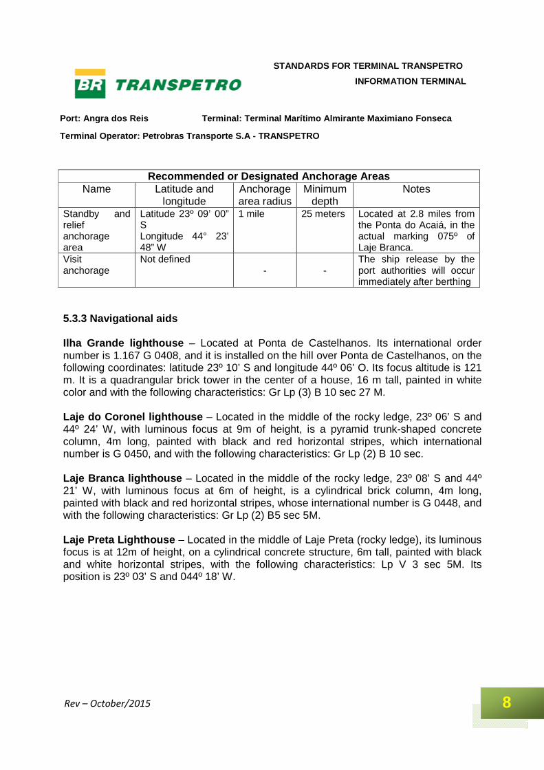
Recommended or Designated Anchorage Areas
Name Latitude and longitude
Anchorage area radius
Minimum depth
Notes
Standby and relief anchorage area
Latitude 23º 09’ 00” S Longitude 44° 23’ 48” W
1 mile 25 meters Located at 2.8 miles from the Ponta do Acaiá, in the actual marking 075º of Laje Branca.
Visit anchorage
Not defined -
-
The ship release by the port authorities will occur immediately after berthing
5.3.3 Navigational aids Ilha Grande lighthouse – Located at Ponta de Castelhanos. Its international order number is 1.167 G 0408, and it is installed on the hill over Ponta de Castelhanos, on the following coordinates: latitude 23º 10’ S and longitude 44º 06’ O. Its focus altitude is 121 m. It is a quadrangular brick tower in the center of a house, 16 m tall, painted in white color and with the following characteristics: Gr Lp (3) B 10 sec 27 M. Laje do Coronel lighthouse – Located in the middle of the rocky ledge, 23º 06’ S and 44º 24’ W, with luminous focus at 9m of height, is a pyramid trunk-shaped concrete column, 4m long, painted with black and red horizontal stripes, which international number is G 0450, and with the following characteristics: Gr Lp (2) B 10 sec. Laje Branca lighthouse – Located in the middle of the rocky ledge, 23º 08’ S and 44º 21’ W, with luminous focus at 6m of height, is a cylindrical brick column, 4m long, painted with black and red horizontal stripes, whose international number is G 0448, and with the following characteristics: Gr Lp (2) B5 sec 5M. Laje Preta Lighthouse – Located in the middle of Laje Preta (rocky ledge), its luminous focus is at 12m of height, on a cylindrical concrete structure, 6m tall, painted with black and white horizontal stripes, with the following characteristics: Lp V 3 sec 5M. Its position is 23º 03’ S and 044º 18’ W.
Port: Angra dos Reis Terminal: Terminal Marítimo Al mirante Maximiano Fonseca
Terminal Operator: Petrobras Transporte S.A - TRANS PETRO
9
STANDARDS FOR TERMINAL TRANSPETRO
INFORMATION TERMINAL
Rev – October/2015
Itaquatiba Island Lighthouse – Located at 45m of height, this is a square brick constructive structure, 5m tall, painted in white color, and with the following characteristics: Lp B 6 sec 5M. Its position is 23° 04’ S and longitude 044º 15’ W; international number G 0420. Ponta do Pasto Lighthouse – Located onshore, near Tebig facilities, at 9m of height. This is a cylindrical concrete structure, 8m tall, at the end of the Ponta do Pasto and near 0.5 mile to west of Ponta do Leme, with the following characteristics: Lp E 3 sec 9M. Its position is 23° 03’ S and longitude 044º 15’ W; international number G 0422. Ilha de Saracura lighthouse – Located at 17m of height. This is a square brick tower, 4m tall, painted in red color and constructed in the middle of the island, with the following characteristics: Lp E 5 sec 5M. Its international number is G 0424. Laje dos Homens lighthouse – Located at 8m of height. This is a cylindrical concrete structure, 5m tall, at the south end of this rocky ledge and 1.1 mile to NE of Laje Preta. Its international number is G 0428. The access channel leading from the anchorage area to the maneuvering basin is signaled by 19 beacons, 9 of them with green 5-sec flashes and 5-mile range, and 10 with red 5-sec flashes and 5-mile range. The lighthouses delimiting the swept channel to the Terminal facilities have the following characteristics: Lp V 5 sec 5M and Lp E 5 sec 5M. 5.3.4 Port limits The official port limits are from the coordinates 23º 18’ S and longitude 44º 30’ W to the coordinates latitude 23° 09’ S and longitude 44º 23’ W. 5.3.5 Pilotage Pilotage is mandatory for all ships maneuvering at the port, berthing or anchoring, from the access channel mouth. The organizations that offer this service are described on section 8.3. Pilotage is arranged for berthing and unberthing by the ship’s cargo agents. The agents provide pilotage for berthing based on their estimated time of arrival (ETA informed by the ships) and on the berthing schedule from the Terminal (informed by the Terminal’s shift supervisor). On unberthing, pilotage is requested via estimated time for concluding the operation (supplied by the ship) and time for releasing the cargo. The minimum time
Port: Angra dos Reis Terminal: Terminal Marítimo Al mirante Maximiano Fonseca
Terminal Operator: Petrobras Transporte S.A - TRANS PETRO
10
STANDARDS FOR TERMINAL TRANSPETRO
INFORMATION TERMINAL
Rev – October/2015
for requesting a pilot is 3.5 hours. For maneuvers from 09:30 p.m., the ship’s agent must request the pilot up to 06:00 p.m. After this time, the pilot could only be called into action for 09:30 a.m. on the next day. The pilots wait for the ships aboard boat or tug, near Ponta do Acaiá, surrounding the coordinates 23º 09’ S and 44º 23’ W. The ships shall carry sufficient ballast and be duly equipped in terms of mooring equipment and its respective accessories. Each captain is solely responsible for the maneuvers and is in charge of all the information to be provided to the pilot about any peculiarity, specific conditions or existing difficulties, such as: engine or boiler problems, problems or damage to navigation aid instruments, mooring lines or any element that may offer risks for mooring, rope release, loading/discharging the ship. After they are berthed, the ships shall remain in conditions deemed satisfactory by the pilot and Terminal operators. Where the captain does not follow the pilot’s instructions, and so as to ensure that the ship maneuvers safely, the port captain shall be notified in writing by the ship’s agency. This fact will be reported to Tebig by the ship’s agency. 5.3.6 Tugs and port services The tug services available are arranged by the cargo ship agents for berthing and unberthing. The agents provide the tugs for berthing based on the vessel size, its estimated time of arrival (ETA informed by the ships) and on the berthing schedule from the Terminal, informed by the Terminal’s shift supervisor. On unberthing, the tugs are requested via estimated time for concluding the operation supplied by the ship and time for releasing the cargo. The rules concerning the number of tugs to be used are described in the section 6.3. The communication form between tugs and ships during berthing and unberthing maneuvers is via VHF radio. This equipment remains permanently turned on in order to answer any call from ships berthed at the pier, or from the Terminal’s operating personnel. In case of equipment failure aboard the ship or tug during the maneuver, the ships will use the following whistle signals: > Call - 4 long whistles, followed by 1 or 2 short ones – the number of short whistles defines if 1 or 2 tug(s), respectively are called. > Before passing the towing rope
Port: Angra dos Reis Terminal: Terminal Marítimo Al mirante Maximiano Fonseca
Terminal Operator: Petrobras Transporte S.A - TRANS PETRO
11
STANDARDS FOR TERMINAL TRANSPETRO
INFORMATION TERMINAL
Rev – October/2015
- 2 short whistles – prepare to push forward or catch the bow rope. - 3 short whistles – prepare to push backwards or catch the aft rope. > After passing the towing rope - 1 long whistle – pull towards starboard. - 2 short whistles – pull towards port side - 3 short whistles – stop pulling. > Maneuvering alongside the ship - 1 short whistle – pull. - 2 short whistles – push. Other whistle signals are also used for auxiliary vessels: > Call - 2 long whistles, followed by a short one – to call the pilot boat. - 1 long whistle, followed by a short one – to call the boat. All the orders received by the tug must be acknowledged by a short whistle. Since the tugs have VHF radios, the maneuvering orders are usually transmitted by phone. The tugs are equipped with Aldis lamps for communication in Morse code. Boats for transporting people – The Terminal does not have boats for transporting people. This service may be requested by the ship’s protecting agent for rental at the Port of Angra dos Reis. Pilotage boat – The pilot uses the pilotage boat provided by the Port of Angra dos Reis. Boat for supply delivery – As the personnel transportation boat, this service is provided by the ship’s agent. The supply of provisions to the ship must occur when it is berthed, in daylight, by the external board of the vessel. The boats contracted must be priorly approved by the Terminal, before approaching the ship. We recommend that the loading/discharging equipment is in good conditions and the procedures are complied with. The Terminal has a mooring service that includes providing two diesel motorboats to assist in maneuvering the ropes. This shift supervisor calls this service into action 3 hours in advance, after the ship’s cargo agents have requested a pilot.
Port: Angra dos Reis Terminal: Terminal Marítimo Al mirante Maximiano Fonseca
Terminal Operator: Petrobras Transporte S.A - TRANS PETRO
12
STANDARDS FOR TERMINAL TRANSPETRO
INFORMATION TERMINAL
Rev – October/2015
5.3.7 Navigation risks The approaching to the TEBIG facilities is made by the west bar, SW-NE direction, between Ponta Grossa de Sítio Forte and Ponta do Algodão, which is located on the southeast end of Gipóia Island, at near 4 miles to northwest. The swept channel, which goes from the anchorage area to the Tebig facilities, presents the following hazards and geographic accidents: Ilha Grande – This island extends from Ponta de Castelhanos, which is its limiting east end near 6 miles to southwest of Marambaia Island, to Ponta do Acaiá, its west end. Its dimensions are 16 miles of extension and 7 miles of width. This is an island of broken terrain, covered in dense vegetation, which goes from its high peaks to the seashore. The highest peak at Ilha Grande is Pedra D’água, 984m tall, near the center of the island. At near 1.5 miles, east-southeast, from Pico da Pedra D’Água there is Pico do Papagaio, which name was given because its shape resembles the beak of a parrot. Its altitude is 963m. Gipóia Island – It is 2.75 miles long, and is located between Ponta do Algodão and Ponta Escalvada, at north. Its highest altitude is 279m, and the island has many large and small bays. Laje Branca – This is a whitish rock without vegetation, located at 1 mile to northeast of Ponta Grande. The descriptions of Laje Branca lighthouse are in the section 5.3.3. Laje do Fundo – This is a rock sounding to 8m. It is located at 1.1 mile NNO from Laje Branca. Laje do Coronel – Awash rock at 4.5 miles NNW from Ponta do Acaiá. Parcel do Coronel, sounding to 0.9 m, is located to west of Laje do Coronel. The descriptions of Laje do Coronel lighthouse are in the section 5.3.3. There are two rocks to SW of Ponta de Jurubaíba, which is the SW end of Gipóia Island. This point is at 2.5 miles NW from Laje do Coronel and to W from Ponta do Algodão. Queimada Grande Island – Located at 2 miles ESE from Ponta do Algodão, with a height of near 40 m. At 0,25 of mile to SSW from Queimada Grande Island, there is Queimada Pequena Island. The passage between this island and Ponta Grossa de Sítio Forte, which is to SSE, has a width of 1.5 mile and is safe.
Port: Angra dos Reis Terminal: Terminal Marítimo Al mirante Maximiano Fonseca
Terminal Operator: Petrobras Transporte S.A - TRANS PETRO
13
STANDARDS FOR TERMINAL TRANSPETRO
INFORMATION TERMINAL
Rev – October/2015
Laje dos Bêbados – This is a rock sounding 10.4 m and located at 0.5 mile to west of Queimada Pequena Island. Pedras Zatim – Located at 0.2 mile NE from Queimada Grande Island, these are clustered dark rocks with low elevation; Laje da Bocaina is at approximately 0.4 mile from these rocks, sounding 8 m. Laje do Mestre Bernardo – This is a rock sounding 8.8m at 0.9 mile NE from Queimada Grande Island. Imboassica Island – Located at near 1.2 miles SE from Ponta do Algodão. Its height is approximately 50m, and at SW there is a series of reefs extending by near 0.1 mile. Laje do Calauzinho and Laje Grande de Imboassica – Both of them sounding less than 1m, located within reefs, at near 0.9 meter SE from Ponta do Algodão. Between them and Ponta do Algodão, there is Laje do Algodão, which is a rock sounding little more than 0.5 meter. Respectively at near 0.6 and 0.8 mile E from Ponta do Algodão, there are Mariquita and Ferros, the first rock sounds 10.5m and second 7m. Sometimes, the sea breaks against Laje dos Ferros. Ponta da Pitangueira – Located on the east coast of Gipóia Island, at near 0.3 mile NNE from Ponta do Algodão. Its coordinates are 23º 03’ 48” S and 44° 20’ 42” W. There is a white brick beacon at SW of Ponta da Pitangueira. Laje Preta do Algodão – Located at near 0.3 mile NNE from Ponta da Pitangueira, this is a dark rock with low elevation. Porcos Grandes Island – Located at 1.5 to 2 miles ENE from Ponta do Algodão. It is the largest in a group of three islands, named as: Porcos Island, with near 75m of height and covered with vegetation; Ilhota dos Porcos, which is the smallest one, located at 0.2 mile SE from the W end of Porcos Grandes Island; and at last, Porcos Pequena Island, located at 0.18 mile NE, with 30m of height and 2 low peaks covered with light green vegetation. At 0.1 mile ESE from Ilhota dos Porcos, there is a small rock sounding near 3.5 m. Laje Preta – Located at 0.5 mile N from the NE end of Porcos Grande Island, this island has 7m of de height, scarce vegetation and dark color. A description of Laje Preta lighthouse is given in the section 5.3.3. Laje do Miguel – Located at near 0.4 mile NE from Laje Preta, this is a rock sounding 7.5m.
Port: Angra dos Reis Terminal: Terminal Marítimo Al mirante Maximiano Fonseca
Terminal Operator: Petrobras Transporte S.A - TRANS PETRO
14
STANDARDS FOR TERMINAL TRANSPETRO
INFORMATION TERMINAL
Rev – October/2015
Ilhas São João – Islands located at 0.7 to 1.1 mile WNW from Porcos Grande Island. These four islands are surrounded by rocky ledges. Ilhas Botinas – Also located at near 0.7 to 1.1 mile WNW from Porcos Grande Island, they are more westerly from Ilhas São João, and are low and with identical appearance. The largest one is São João Island, which is located more westerly, with Redonda Island near of it and more southerly. Laje de São João – Located at a distance little more than 0.5 mile SW between Botinas Island and Laje Preta do Algodão, this rock emerges with tide. Laje Chata – Located at near 0.12 mile NE from Botinas Island, this rock is delimited by a triangular 3-m beacon, sounding 1m. A rock, sounding 3m, is located at near 0.12 mile from Ponta do Pasto, a point on the east coast of Gipóia Island, which should not be confused with other point with the same name on the shore, on which there is a lighthouse. Its coordinates are latitude 23º 04’ S and longitude 044º 21’ W. Piedade Island – Located to east of Ponta da Piedade, NE end of Gipóia Island, at near 0.7 mile NO from Ponta do Pasto. Piedade Island is 31m high. Almeida Island is at 0.35 mile from Ponta da Piedade. There is a rock between the two islands, sounding 1.8m. Laje do Almeida – Located at 0.2 mile SE from Almeida Island. Its smallest depth is 2.7m. Laje do Pendão – Located at 0.35 mile N from Almeida Island. This rocky ledge, sounding 3m, is delimited at west by a blind buoy painted with black and red stripes. Itacuatiba Island – Located at east from those approaching to the Jacuacanga Bay, at near 1 mile SSW from Ponta do Pasto (onshore) and near 1 mile WNW from Macacos Island, this island is covered with scarce vegetation. The descriptions of Itacuatiba Island lighthouse are in the section 5.3.3. Laje de Itacuatiba – This is a rock sounding to 6.4m and located at 0.4 mile NE from Itacuatiba lighthouse. It is delimited by a blind buoy painted in black color at NE of the rocky ledge.
Port: Angra dos Reis Terminal: Terminal Marítimo Al mirante Maximiano Fonseca
Terminal Operator: Petrobras Transporte S.A - TRANS PETRO
15
STANDARDS FOR TERMINAL TRANSPETRO
INFORMATION TERMINAL
Rev – October/2015
Saracura Island – Located at 1.25 miles NW from Itacuatiba Island, this island has scarce vegetation. At 0.1 mile NNE direction, there are reefs sounding 5.5m, delimited at north by a buoy painted in black color. The lighthouse on the rocky ledge is described in the section 5.3.3. Laje de Saracura – This is a rock sounding 7m. At 0.45 mile from Saracura Island lighthouse, at north, it is delimited by a blind buoy painted with black and red stripes. Laje do Despique – This is a rock sounding to 8.8 m and located at 0.2 mile NNE from Saracura Island. Lajes do Badejo – These are 2 rocks sounding 7 to 8 m and located near Laje da Saracura. Located at near 0.35 mile NNE from Saracura Island, they are distant 0.1 mile each other. Laje do Sabonete Pequeno and Laje do Sabonete Grand e – The first sounds 2.4 m and the second, 6.7 m. They are located at 0.12 mile W and 0.2 mile WNW, respectively, from Ponta do Leste, east end of Jacuacanga Bay, at near 0.4 mile NW from Ponta do Pasto (onshore). The red blind buoy at west from these rocks is at 0.2 mile W from Ponta do Leste. Laje dos Homens – Located between Saracura Island and the continent, at 1.75 miles WNW from the first; at near 0.8 mile at north, there is Guaxima Island. Both are constituted by low rocks. Some submerged rocks emerge with tide and are located at near 0.1 mile N from Laje dos Homens. The lighthouse on the rocky ledge is described in the section 5.3.3. Laje Alagada – Located at 0.2 mile NNW from Laje dos Homens lighthouse, it is partially exposed with tide. There is a red beacon on this rocky ledge. Laje Baixa – Located at 100 m SE from Laje Alagada. This rocky ledge sounds 2.5 m. Laje Duas Irmãs – This is a rock sounding to 2.7m and located at 1.1 mile NNW from Ponta do Leste. It is delimited by a light buoy with black and red stripes, exhibiting Gp Lp (2) B 10 sec 5M. Macacos Island – Located near the north end of Ilha Grande. Ponta do Luiz – This is the north end of Macacos Island, and is located at 1.5 mile NE from Ponta do Bananal.
Port: Angra dos Reis Terminal: Terminal Marítimo Al mirante Maximiano Fonseca
Terminal Operator: Petrobras Transporte S.A - TRANS PETRO
16
STANDARDS FOR TERMINAL TRANSPETRO
INFORMATION TERMINAL
Rev – October/2015
Comprida Island – Its west end is located at 0.2 mile SW from Ponta do Luiz. Aroeira Island – Small island located at 0.12 mile N from Ponta do Luiz (latitude 23º 05’ S and longitude 044º 14’ W). Laje da Ilha Comprida – This is a rock sounding 8m and located at 0.3 mile WNW from the west end of Comprida Island. At near 0.25 mile NE from Ponta do Leste, a monument was constructed at a height of 69.5m (228 feet). On the beach located in the mouth of Ilha Grande Bay, there are the ruins of an old abandoned convent. These ruins are not clearly visible from the mouth of the bay. Laje Maciel – Located at west of Ponta do Gambelo and 0.3 mile SO from Ponta dos Coqueiros, sounding 6.4 m (21 feet). A rock sounding 7.3m (24 feet) is located at south of Laje do Maciel. 5.3.8 General restrictions There are no restrictions on maneuvering ships at night. The maximum speed limit recommended for port maneuvers: >Wind = 20 knots. >Current = 1 knot. Only one ship at time may navigate along the beacon signaled channel. The maximum permitted speed for the ships approaching the access channel for berthing in Tebig is 6 knots. The ship must remain parallel to the berthing pier, at a minimum distance of 100m, and from this point, it must respect the maximum speed limit of 15cm/sec, as per Table 6.3. 5.4 Maneuver Areas The maneuver basin, close to the pier, is about 0.6 mile long in the N-S direction, 1.3 mile in the E-W direction and is more than 30 meters deep. Transshipment operations are carried out with the vessels berthed, by using the interconnection alignments of the Terminal berths.
Port: Angra dos Reis Terminal: Terminal Marítimo Al mirante Maximiano Fonseca
Terminal Operator: Petrobras Transporte S.A - TRANS PETRO
17
STANDARDS FOR TERMINAL TRANSPETRO
INFORMATION TERMINAL
Rev – October/2015
5.4.1 Navigational and berthing aids The Terminal has docking radar equipment available for measuring the speed and the approach angle of the vessel at the berth. The Terminal operator assists the ship when it is berthing so as to position it in such a way that the loading arms can be connected. 5.4.2 Depth control At Tebig, the draft limit for berthing and unberthing at the berths is 25 meters at any time of the year. The points that delimit the maximum berthing draft at the Terminal are located in the access channel and described in the nautical charts, as per section 3. 5.4.3 Maximum dimensions The maximum ship size for berthing at Tebig is 500,000 DWT for berthing at P-1 (external berth) and 350,000 DWT at P-2 (internal berth). 5.5 Environmental Factors The region where the TEBIG is located presents high relative air humidity, ranging from 76% to 81%, while the atmospheric pressure is around 1,015 mba with good weather; and the local temperature ranges from 18° C (64.4º F), in June and July, to 35º C (95°F), in December and January. Other meteorological information for the region are shown below: 5.5.1 Prevailing winds In the autumn and winter seasons, fresh and cold winds are common in the coast from Rio de Janeiro to Santos. In daylight, the breeze “viração”) tends to increase the easterly wind component; on the other hand, at night, the westerly component prevails. At night, the wind speed tends to decrease, reaching calm conditions around 08:00 p.m. Due to the high mountains in Ilha Grande, the east winds, which prevail in the region, blow from several directions and exhibit speeds ranging from 3 to 15 knots.
Port: Angra dos Reis Terminal: Terminal Marítimo Al mirante Maximiano Fonseca
Terminal Operator: Petrobras Transporte S.A - TRANS PETRO
18
STANDARDS FOR TERMINAL TRANSPETRO
INFORMATION TERMINAL
Rev – October/2015
The southwest winds, brought by cold fronts, more frequent in the afternoon period, are more intense and raise the sea quite a bit in protected locations. Their speed ranges from 20 to 60 knots. Usually, in sheltered areas, ports, bays and channels in the region, the winds (moderate to fresh) blow soon after noon, when they contribute for decreasing the temperature. Northeast winds, with fewer incidence, but frequent in the dawn and morning periods, blow with speeds ranging from 3 to 20 knots. 5.5.2 Waves and swells For being in a sheltered area, Ilha Grande Bay does not have significant variations of waves or swells. 5.5.3 Rainfall The heaviest rainfall in the region occurs in the evening, and sometimes lasts all night. These rains are more frequent during spring and summer seasons. The annual rainfall average in the region is about 2.000 mm. Historically, there is no incidence of hailstorm or snow in the region. 5.5.4 Lightning storms Lightning storms are more frequent during the spring and summer seasons, in the afternoon and evening periods. The elements contributing to their occurrence are the cold fronts and high temperatures during the day. 5.5.5 Visibility In general, visibility is good, but haze occurs in the early hours of the morning, during the autumn and winter seasons. Sometimes during the summer period, a dry mist appears, thus reducing visibility. 5.5.6 Tidal currents and other currents On tide rising, the current flows approximately from east to west, almost parallel to the pier’s berth. The current variation in this direction is from 0.1 to 1 knot.
Port: Angra dos Reis Terminal: Terminal Marítimo Al mirante Maximiano Fonseca
Terminal Operator: Petrobras Transporte S.A - TRANS PETRO
19
STANDARDS FOR TERMINAL TRANSPETRO
INFORMATION TERMINAL
Rev – October/2015
On falling tide, the current flows approximately from west to east, the reverse of flood tide. The current variation in this direction is from 0.1 to 2 knots. The strong winds from northeast, south and southwest have influence on the current direction, which follows their direction. There are no noticeable tidal currents in the region. 5.5.7 Tide level variation The approximate average regular tide amplitude at the Terminal is of 1.10 meter (4 feet), but during syzygy tide there are greater variations, with up to 1.7 meter (4.5 feet). The maximum draft for berthing at Tebig has been calculated according to the worst tide condition. 5.5.8 Measurements The Terminal provides instant information about wind and current intensity and direction. When the vessels are approaching for berthing, this information may be provided via VHF radio, by the terminal operator to the onboard representative. 6 DESCRIPTION OF THE TERMINAL 6.1 General Description The Tebig pier has 2 berths (P01 – External berth and P02 – Internal berth). This pier, which starts at Ponta do Leme, extending along 1,318m, east-west direction, has an L-shape and is located in front of the center portion of Ilha Grande Bay.
Port: Angra dos Reis Terminal: Terminal Marítimo Al mirante Maximiano Fonseca
Terminal Operator: Petrobras Transporte S.A - TRANS PETRO
20
STANDARDS FOR TERMINAL TRANSPETRO
INFORMATION TERMINAL
Rev – October/2015
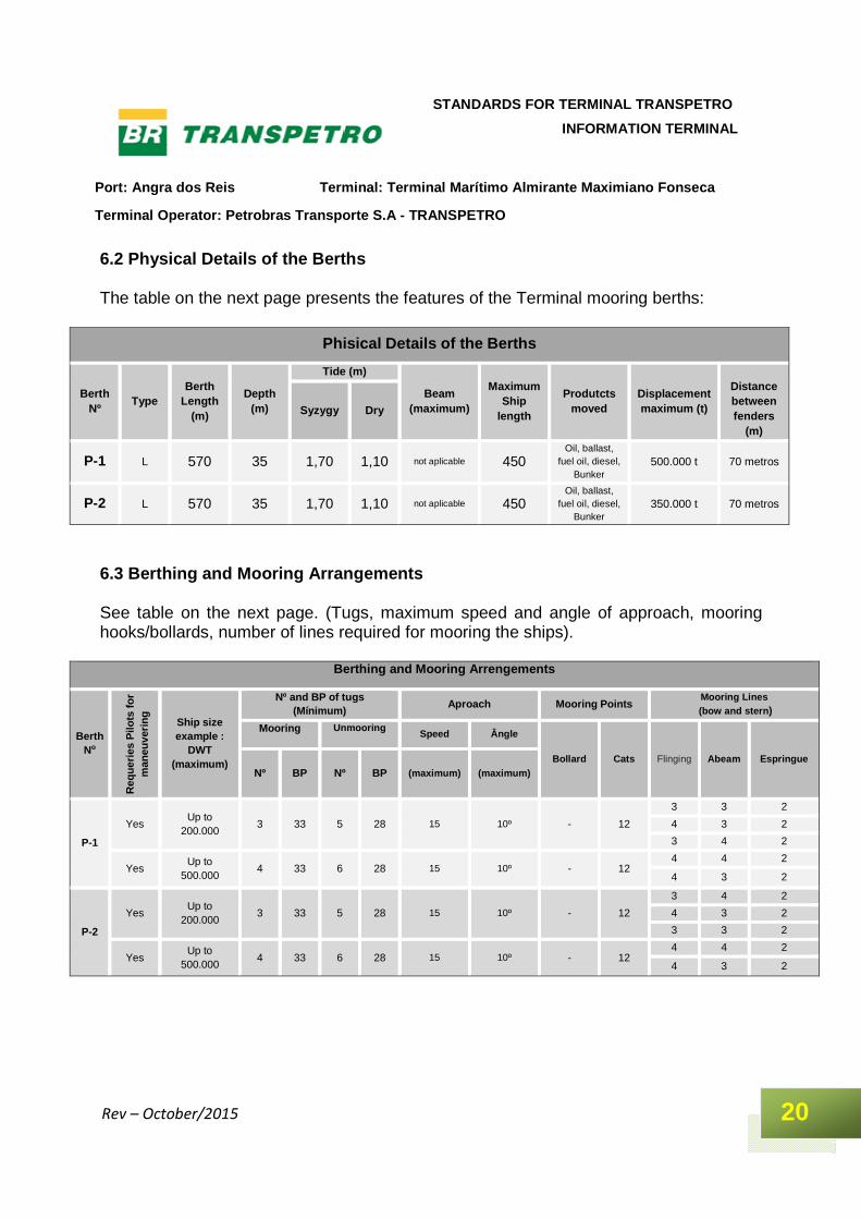
6.2 Physical Details of the Berths The table on the next page presents the features of the Terminal mooring berths:
Phisical Details of the Berths
Berth Nº
Type Berth
Length (m)
Depth (m)
Tide (m)
Beam (maximum)
Maximum Ship
length
Produtcts moved
Displacement maximum (t)
Distance between fenders
(m)
Syzygy Dry
P-1 L 570 35 1,70 1,10 not aplicable 450 Oil, ballast,
fuel oil, diesel, Bunker
500.000 t 70 metros
P-2 L 570 35 1,70 1,10 not aplicable 450 Oil, ballast,
fuel oil, diesel, Bunker
350.000 t 70 metros
6.3 Berthing and Mooring Arrangements See table on the next page. (Tugs, maximum speed and angle of approach, mooring hooks/bollards, number of lines required for mooring the ships).
Berthing and Mooring Arrengemen ts
Berth No
Req
uerie
s P
ilots
for
man
euve
ring Ship size
example : DWT
(maximum)
Nº and BP of tug s (Mínimum)
Aproach Mooring Points Mooring Lines
(bow and stern )
Mooring Unmooring Speed Ângle
Bollard Cats Flinging Abeam Espringue Nº BP Nº BP (maximum) (maximum)
P-1
Yes Up to
200.000 3 33 5 28 15 10º - 12
3 3 2
4 3 2
3 4 2
Yes Up to
500.000 4 33 6 28 15 10º - 12
4 4 2
4 3 2
P-2
Yes Up to
200.000 3 33 5 28 15 10º - 12
3 4 2
4 3 2
3 3 2
Yes Up to
500.000 4 33 6 28 15 10º - 12
4 4 2
4 3 2
Port: Angra dos Reis Terminal: Terminal Marítimo Al mirante Maximiano Fonseca
Terminal Operator: Petrobras Transporte S.A - TRANS PETRO
21
STANDARDS FOR TERMINAL TRANSPETRO
INFORMATION TERMINAL
Rev – October/2015
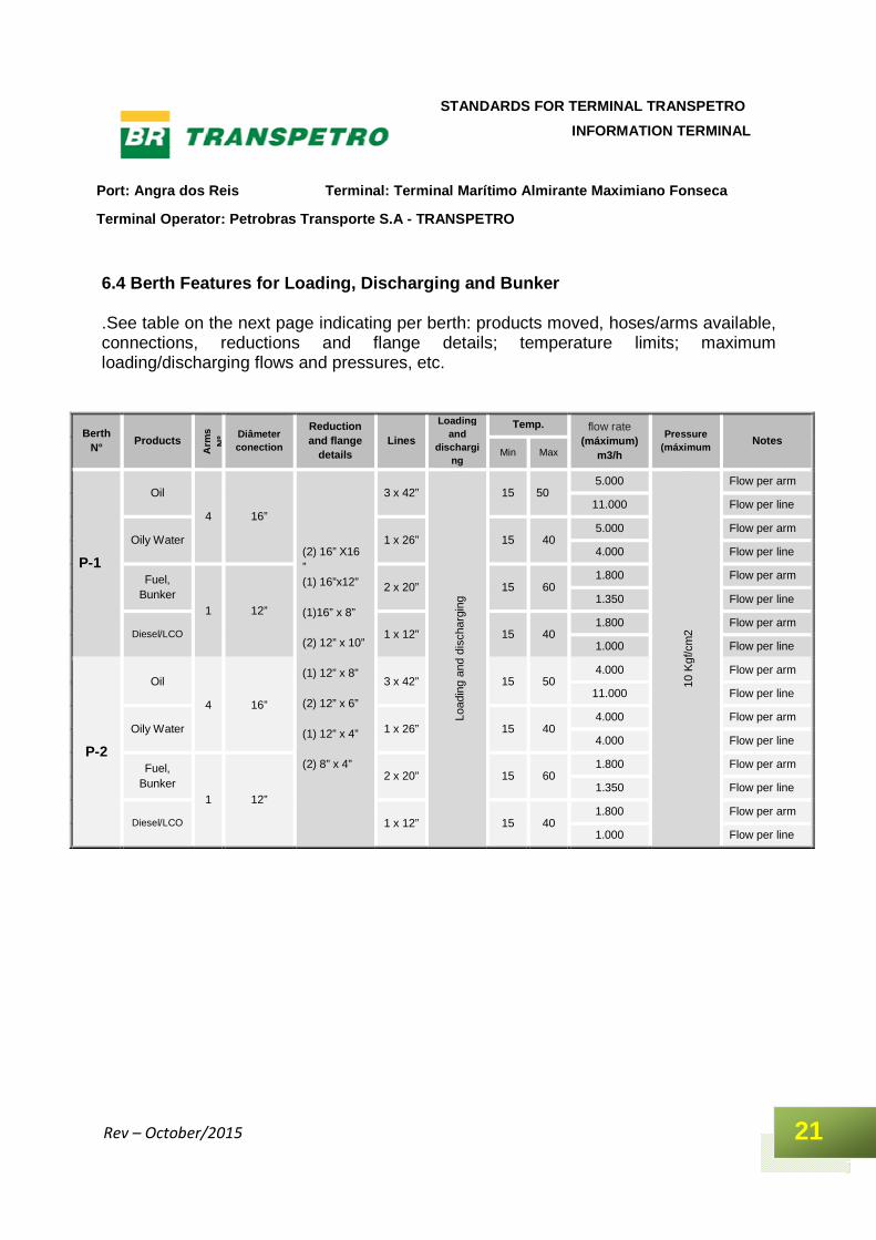
6.4 Berth Features for Loading, Discharging and Bun ker .See table on the next page indicating per berth: products moved, hoses/arms available, connections, reductions and flange details; temperature limits; maximum loading/discharging flows and pressures, etc.
Berth N°
Products
Arm
s N
º
Diâmeter conection
Reduction and flange
details Lines
Loading and
discharging
Temp. flow rate (máximum)
m3/h
Pressure (máximum
Notes Min Max
P-1
Oil
4 16”
(2) 16” X16 ” (1) 16”x12” (1)16” x 8” (2) 12” x 10” (1) 12” x 8” (2) 12” x 6” (1) 12” x 4” (2) 8” x 4”
3 x 42”
Load
ing
and
disc
harg
ing
15 50 5.000
10 K
gf/c
m2
Flow per arm
11.000 Flow per line
Oily Water 1 x 26” 15 40 5.000 Flow per arm
4.000 Flow per line
Fuel, Bunker
1 12”
2 x 20” 15 60 1.800 Flow per arm
1.350 Flow per line
Diesel/LCO 1 x 12” 15 40 1.800 Flow per arm
1.000 Flow per line
P-2
Oil
4 16”
3 x 42” 15 50 4.000 Flow per arm
11.000 Flow per line
Oily Water 1 x 26” 15 40 4.000 Flow per arm
4.000 Flow per line
Fuel, Bunker
1 12”
2 x 20” 15 60 1.800 Flow per arm
1.350 Flow per line
Diesel/LCO 1 x 12” 15 40 1.800 Flow per arm
1.000 Flow per line
Port: Angra dos Reis Terminal: Terminal Marítimo Al mirante Maximiano Fonseca
Terminal Operator: Petrobras Transporte S.A - TRANS PETRO
22
STANDARDS FOR TERMINAL TRANSPETRO
INFORMATION TERMINAL
Rev – October/2015
6.5 Management and Control The Tebig control room is located at the oil storage area, approximately 11 km from the main pier. The operator in charge of controlling all Terminal operations works in this central room, using the supervision system. There is one room in the pier, where the operators of that section prepare the documentation, handle the communications and monitor the berthing and positioning of ships. Communications with the ships are carried out via VHF radios in maritime frequencies previously agreed and registered. A secondary means, using land-based VHF radio, is agreed upon if the main system fails. 6.6 Major Risks The major risks associated with ships’ laytime in the Tebig berths are: > When exposed due to the absence of a large ship in the external berth (P-1), the ship berthed in the internal berth (P-2) is more vulnerable due to the position of the berth, when there is the incidence of strong current in the west-east direction, with the risk of the bow moving away from the pier defenses, when berthed by starboard. > The same hazard may occur due to the incidence, under the previous conditions, of strong southwest wind. The risks previously described require greater attention from the ships’ crews where the mooring lines are concerned. 7 PROCEDURES During the ship laytime at the port, various steps are taken to make it possible to operate safely and manage the risks, in order to minimize them. At every stage, as described below, measures are taken so as to facilitate the operations and plan them adequately. 7.1 Before Arrival 7.1.1 When berthing, and after the safety inspection made by the Safety Inspector (Giaont), based on the Isgott checklist, the ship will not be authorized by the Terminal to start its operations if there are pending issues not solved by the crew.

Port: Angra dos Reis Terminal: Terminal Marítimo Al mirante Maximiano Fonseca
Terminal Operator: Petrobras Transporte S.A - TRANS PETRO
23
STANDARDS FOR TERMINAL TRANSPETRO
INFORMATION TERMINAL
Rev – October/2015
7.1.2 On-board repairs and washing the ship’s cargo tank should be preferably carried out in the anchorage area. To carry out these services with the ship berthed, prior authorization from the Terminal will be necessary. 7.1.3 Ships heading to the Tebig facilities must indicate their estimated time of arrival (ETA) 72 and 48 hours in advance, directly to the respective agent, via PPR (Rio Rádio Estação Costeira Oficial). Change to or confirmation of the ship’s arrival shall be communicated at least 24 hours in advance. The ETA information must specify whether the time informed is local or UTC. 7.2 Arrival 7.2.1 The port authorities are brought into play by the ships’ agents according to the arrival and berthing schedule. Usually, the visit is made after berthing. 7.2.2 The bunker supply requests must be forwarded, via the agent, to UN-Bunker. 7.2.3 Information about the ship to be sent to the Terminal is described in Appendix D. 7.2.4 Please find below the list of important addresses and telephone numbers at the port: Receita Federal (Internal Revenue Service) Largo da Lapa, 35 – Centro Angra dos Reis – RJ – Brazil Phone: (55 24)3365-1730 / 3365-1992 / 3365-3503
Port: Angra dos Reis Terminal: Terminal Marítimo Al mirante Maximiano Fonseca
Terminal Operator: Petrobras Transporte S.A - TRANS PETRO
24
STANDARDS FOR TERMINAL TRANSPETRO
INFORMATION TERMINAL
Rev – October/2015
Police Department Rua Doutor Coutinho, 83 – Centro Angra dos Reis – RJ – Brazil Phone: (55 24) 3365-0027 / 3399-9084 / 3377-8611 / 3377-8553 Military Políce de Angra dos Reis (7ª DRPC) (Milita ry Police) Rod Governador Mario Covas – Km 142 - Perequê Angra dos Reis – RJ -Brazil Phone: (55 24) 3399-9080 / (55 24) 3362-3190 / (55 21) 3399-9157 Policlínica da Cidade Rua Doutor Moacir de Paula Lobo, 75 – Centro Antiga Rua das Palmeiras - Angra dos Reis – Brazil Phone: (55 24) 3369-6138 7.3 Berthing 7.3.1 Ship mooring system The mooring lines must be looked after constantly so that the ship always remains berthed. All the lines must be kept under adequate tension during the operation, and winches with their brakes activated. The use of automatic tensioning winches is not permitted. All the mooring lines must be of the same type, gauge and material (fiber or wire); mixed mooring lines are not permitted. Mixed mooring lines are those in which the lines performing the same function are of different type, gauge and materials. The mooring lines must be arranged as symmetrically as possible in relation to the middle of the ship. The breast lines must be deployed as perpendicularly as possible to the longitudinal axis of the ship, and passed as much as possible forward and aft. Spring lines must be oriented as parallel as possible to the longitudinal axis of the ship. When tails are used on the wire lines, they shall be of the same type, with gauge 25% greater than the minimum breaking load of the wire, same material and length.
Port: Angra dos Reis Terminal: Terminal Marítimo Al mirante Maximiano Fonseca
Terminal Operator: Petrobras Transporte S.A - TRANS PETRO
25
STANDARDS FOR TERMINAL TRANSPETRO
INFORMATION TERMINAL
Rev – October/2015
The horizontal angle of bow and stern lines relative to a breast line perpendicular to the ship’s longitudinal axis must not exceed 45°. 7.3.2 Ship/shore access The Tebig piers have telescopic ladders for easily accessing the berthed ships. The crew members who use the Terminal facilities on disembarkation, must use closed leather shoes, long pants and shirts with sleeves, and circulate only within the demarcated area as far as the expansion curve, where there will be a vehicle to take them to the exit gate. 7.4 Before Transferring the Cargo 7.4.1 - The loading arms have joined with electrical isolation. 7.4.2 The resources required for the connection are agreed upon the first contact between the ship and the Terminal. The ship must provide the manifold diameters to enable connecting the loading arms. After connecting the loading arms, they will be tested for tightness, using the static Terminal’s column pressure for this purpose. One onboard representative will inspect the entire operation, and must be near the ship’s manifold. 7.4.3 Onboard measurements are executed by the ship’s personnel, and inspected by the Terminal’s representatives and other inspectors. The material used must be properly grounded, and the measurement instruments must be explosion-proof. 7.4.4 The operation can only start after the initial letter has been filled in by onshore and onboard representatives. 7.4.5 The ship/shore safety checklist (Isgott, Appendix A) is checked and filled out by the Safety Inspector (Giaont) during the initial release of the ship. 7.4.6 Boiler pipes should not be cleaned while the ship is berthed. Precautions for preventing the escape of sparks through the smokestack must be taken. The non-compliance with this regulation will cause one or more of the sanctions below: >immediate interruption of the operations; > penalties will be applied by the competent authorities; > ship will be obliged to unberth from the pier;

Port: Angra dos Reis Terminal: Terminal Marítimo Al mirante Maximiano Fonseca
Terminal Operator: Petrobras Transporte S.A - TRANS PETRO
26
STANDARDS FOR TERMINAL TRANSPETRO
INFORMATION TERMINAL
Rev – October/2015
> ship owners will be informed about the infraction; and > ship will be held responsible for the fines applied, demurrage and all other related expenses resulting from this fact. 7.4.7 The prohibition of non-authorized small boats remaining alongside or near berthed ships shall be strictly observed. Only the Terminal service vessels or authorized vessels may remain in the vicinity or side by side, provided that they meet all safety conditions. The violation of this rule shall be communicated to the competent authority. 7.4.8 The berthed ships must not run their propeller(s) while connected to the loading arms. The jacking gear may be used, once the Terminal operator has been duly notified; however, the propeller must be turned slowly in order to ensure absolute safety. Ships will be held responsible for any damages resulting from these procedures. 7.5 Cargo Transfer 7.5.1 The monitoring of pressures during cargo transfer is recorded by the onboard and onshore representatives at the ship’s manifold, hour by hour. The Terminal controls the internal pressure variables by means of a centralized control supervision system. The flow rates on both sides of the operation are measured hour by hour, and compared between the parties, and according to the system used, there will be a limiting parameter for operational control. Any changes in the operating conditions must be communicated and documented between the parties. It is expressly forbidden to close valves that may cause counter-pressure in the system during the operation. 7.5.2 Ballast and deballast pipes and tanks must be designated for this purpose only, and remain isolated from other pipes aboard. The water ballast for discharge into the sea must be totally free of oil, any oily residues or substances that may pollute the seawater. 7.5.3 The Transpetro schedule, which interacts with the Petrobras logistics, provides tanks at the Terminal for receiving slop from the ships. Where the ship has to discharge slop in Angra dos Reis, it shall inform, via its agent, the quantity to be discharged and origin thereof. The system used by the Terminal for discharging slop is the same employed for other products, by using lines set up for this purpose. 7.5.4 Usually, the conventional tank cleaning operation is not accepted. However, COW operations are accepted, depending on prior authorization from the schedule as regards ship laytime at the port, and from the Safety Inspector (Giaont) as regards operational safety purposes.
Port: Angra dos Reis Terminal: Terminal Marítimo Al mirante Maximiano Fonseca
Terminal Operator: Petrobras Transporte S.A - TRANS PETRO
27
STANDARDS FOR TERMINAL TRANSPETRO
INFORMATION TERMINAL
Rev – October/2015
7.5.5 No repairs or maintenance work involving a risk of sparks or other forms of ignition can be carried out while the ship is berthed on the Terminal piers. In extreme cases, all the safety rules shall be complied with and fulfilled. Repairs involving the pier facilities, or that imply any restriction on the ship during the laytime, must have prior authorization from the Terminal. 7.5.6 The intermediate inspections, according to Appendix A of Isgott, will be performed by The Safety Inspector (Giaont) during the ship operation every 6 hours. 7.5.7 Loading or discharging must be interrupted in any situation that might offer risk, either to the ship or the Terminal. The operations may be temporarily suspended during lightning storms, thunderstorms and/or squalls. The operating personnel at the Terminal is authorized to interrupt/suspend the operation in case of non-compliance with any safety-related rules and standards globally accepted and adopted in the maritime transportation of oil. The ship’s captain is entitled to interrupt the operation when there are reasons to believe that the operations ashore are not safe, provided he notifies the pier operators in advance. 7.5.8 In any emergency situation, Angra dos Reis Marine Terminal will interrupt the operations in progress so that all available resources are focused on mitigating the disaster. The actions and contacts for every type of emergency are described in the management’s LCP and the key telephones are listed in section 9. 7.6 Cargo Measurement and Documentation 7.6.1 After finishing the operation, drainage of the loading arms used must commence. The Terminal operators will arrange for the used arms to be drained to a closed system on the pier. The ship’s representative must arrange for the onboard section to be drained. 7.6.2 The final onboard measurements will be carried out by the ship’s personnel, and inspected by the Terminal’s representatives and other inspectors. The material used must be properly grounded, and the measurement instruments must be explosionproof. The final ship release will occur after comparing the quantities moved and after complementing the laytime documentation. 7.7 Unberthing and Leaving the Port
Port: Angra dos Reis Terminal: Terminal Marítimo Al mirante Maximiano Fonseca
Terminal Operator: Petrobras Transporte S.A - TRANS PETRO
28
STANDARDS FOR TERMINAL TRANSPETRO
INFORMATION TERMINAL
Rev – October/2015
7.7.1 During the unberthing and port leaving maneuvers, the channel limits and hazards, listed in the section 5.3 and its sub-items, must be observed. 7.7.2 Usually, the pilot disembarks at the same embarkation point described in section 5.3.5, where a pilotage boat from the port will be waiting for him. 7.8 - Customer Service ISPS Code. 7.8.1 - The Terminal in Angra dos Reis has implemented measures to protect corporate security for ships and port facilities, pursuant to the requirements of the International Maritime Organization - IMO, by adopting the ISPS - International Ship and Port Facility Security Code. In case of need, these protective measures can be triggered by ship through the port security supervisor Terminal (PFSO) or VHF radio channel call 16, 9 or 8. 7.8.2 - The Terminal in Angra dos Reis normally operates at level 1 security. For more information, the supervisor of the Terminal port security, which is qualified according to the requirements of the IMO, can be contacted at Tel .: (55 24) 3366-5251. 8 PORT AND ANCHORAGE AREA ORGANIZATION 8.1 Port Control or VTS This section does not apply to TEBIG. 8.2 Maritime Authority 8.2.1 The maritime authority the Terminal is subordinated to is the Harbor Master of Angra dos Reis. 8.2.2 The officer at the Angra dos Reis Harbor Master determines that the visit of authorities occurs after unberthing the ship on the TEBIG pier. 8.2.3 The official port limits are from the coordinates 23º 18’ S and longitude 44º 30’ W to the coordinates latitude 23° 09’ S and longitude 44º 23’ W, as per section 5.3.4. 8.2.4 - The Harbor Master is the maritime authority within the limits of the Port of Angra dos Reis. It is responsible for deciding what actions to take, and for penalizing those responsible for any incident within the port limits.
Port: Angra dos Reis Terminal: Terminal Marítimo Al mirante Maximiano Fonseca
Terminal Operator: Petrobras Transporte S.A - TRANS PETRO
29
STANDARDS FOR TERMINAL TRANSPETRO
INFORMATION TERMINAL
Rev – October/2015
8.3 Pilotage 8.3.1 The pilotage is mandatory for all ship maneuvers as from the pilot’s point of embarkation (section 5.3.5). 8.3.2 The Pilotage organization operating at the An gra dos Reis ATALAIA MANGARATIBA - Mangaratiba Estrada RJ 14, 118 – Casa 02 – Alto do Ibicuí – Mangaratiba – RJ – Brazil Phone: (55 21) 2789-1278 / (55 21) 2789-1344 RIO PILOTS / SIND PILOT Angra dos Reis Rua Coronel Carvalho, 173/ 407 ZIP Code: 23900-000 – Centro – RJ – Brazil Telefax: (55 24) 3365-0886 Mangaratiba Av. Mangaratiba, 61/ loja ZIP Code: 23860-000 – Centro – RJ – Brazil Phone: (55 21) 2789-1422 Telefax: (55 21) 2789-1397 / 9987-7035 Rio de Janeiro Av. Rio Branco, 4 – salas 1501/03 e 1401/03 ZIP Code: 20090-000 – Centro – RJ – Brazil Phone: (55 21) 2516-1336 Fax (55 21) 2233-9738 8.3.3 For all the situations, the pilotage service is called into action by the ship’s agent. In case of emergency, according to availability, the pilot will embark on the ship at the first opportunity. 8.4 Tugs and other Maritime Services
Port: Angra dos Reis Terminal: Terminal Marítimo Al mirante Maximiano Fonseca
Terminal Operator: Petrobras Transporte S.A - TRANS PETRO
30
STANDARDS FOR TERMINAL TRANSPETRO
INFORMATION TERMINAL
Rev – October/2015
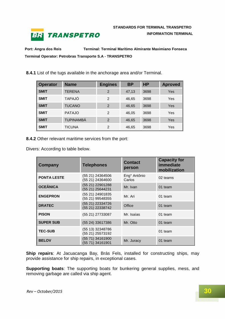
8.4.1 List of the tugs available in the anchorage area and/or Terminal.
Operator Name Engines BP HP Aproved
SMIT TERENA 2 47,13 3698 Yes
SMIT TAPAJÓ 2 46,65 3698 Yes
SMIT TUCANO 2 46,65 3698 Yes
SMIT PATAJO 2 46,05 3698 Yes
SMIT TUPINAMBÁ 2 46,65 3698 Yes
SMIT TICUNA 2 46,65 3698 Yes
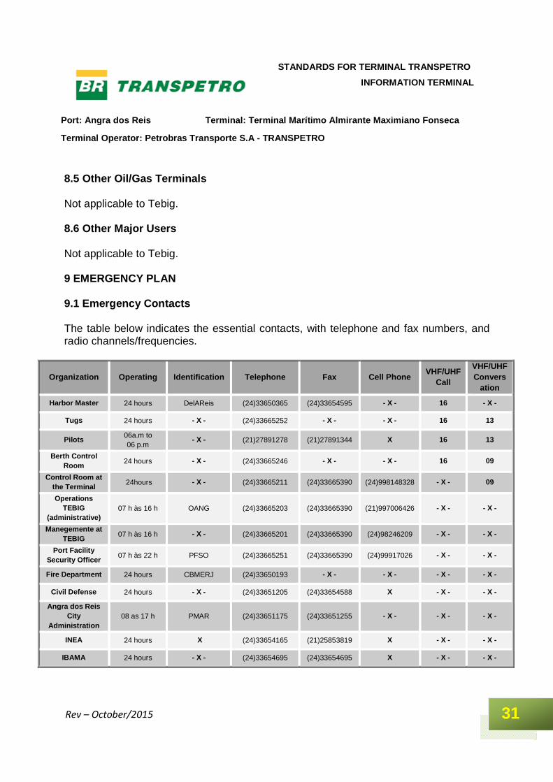
8.4.2 Other relevant maritime services from the port: Divers: According to table below.
Company Telephones Contact person
Capacity for immediate mobilization
PONTA LESTE (55 21) 24364506 (55 21) 24364600
Eng° Antônio Carlos
02 teams
OCEÂNICA (55 21) 22901288 (55 21) 25644231 Mr. Ivan 01 team
ENGEPRON (55 21) 24901835 (55 21) 99548355
Mr. Ari 01 team
DRATEC (55 21) 22334726 (55 21) 22338742
Office 01 team
PISON (55 21) 27733087 Mr. Isaías 01 team
SUPER SUB (55 24) 33617386 Mr. Otto 01 team
TEC-SUB (55 13) 32348786 (55 21) 25573192
01 team
BELOV (55 71) 34161900 (55 71) 34161901
Mr. Juracy 01 team
Ship repairs : At Jacuacanga Bay, Brás Fels, installed for constructing ships, may provide assistance for ship repairs, in exceptional cases. Supporting boats : The supporting boats for bunkering general supplies, mess, and removing garbage are called via ship agent.
Port: Angra dos Reis Terminal: Terminal Marítimo Al mirante Maximiano Fonseca
Terminal Operator: Petrobras Transporte S.A - TRANS PETRO
31
STANDARDS FOR TERMINAL TRANSPETRO
INFORMATION TERMINAL
Rev – October/2015
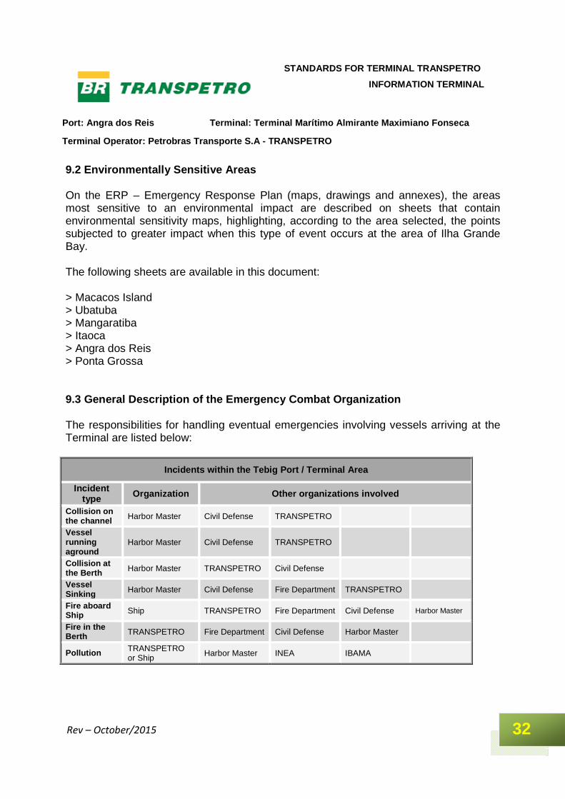
8.5 Other Oil/Gas Terminals Not applicable to Tebig. 8.6 Other Major Users Not applicable to Tebig. 9 EMERGENCY PLAN 9.1 Emergency Contacts The table below indicates the essential contacts, with telephone and fax numbers, and radio channels/frequencies.
Organization Operating Identification Telephone Fax Cell Phone VHF/UHF
Call
VHF/UHF Convers
ation
Harbor Master 24 hours DelAReis (24)33650365 (24)33654595 - X - 16 - X -
Tugs 24 hours - X - (24)33665252 - X - - X - 16 13
Pilots 06a.m to 06 p.m
- X - (21)27891278 (21)27891344 X 16 13
Berth Control Room
24 hours - X - (24)33665246 - X - - X - 16 09
Control Room at the Terminal
24hours - X - (24)33665211 (24)33665390 (24)998148328 - X - 09
Operations TEBIG
(administrative) 07 h às 16 h OANG (24)33665203 (24)33665390 (21)997006426 - X - - X -
Manegemente at TEBIG
07 h às 16 h - X - (24)33665201 (24)33665390 (24)98246209 - X - - X -
Port Facility Security Officer
07 h às 22 h PFSO (24)33665251 (24)33665390 (24)99917026 - X - - X -
Fire Department 24 hours CBMERJ (24)33650193 - X - - X - - X - - X -
Civil Defense 24 hours - X - (24)33651205 (24)33654588 X - X - - X -
Angra dos Reis City
Administration 08 as 17 h PMAR (24)33651175 (24)33651255 - X - - X - - X -
INEA 24 hours X (24)33654165 (21)25853819 X - X - - X -
IBAMA 24 hours - X - (24)33654695 (24)33654695 X - X - - X -
Port: Angra dos Reis Terminal: Terminal Marítimo Al mirante Maximiano Fonseca
Terminal Operator: Petrobras Transporte S.A - TRANS PETRO
32
STANDARDS FOR TERMINAL TRANSPETRO
INFORMATION TERMINAL
Rev – October/2015
9.2 Environmentally Sensitive Areas On the ERP – Emergency Response Plan (maps, drawings and annexes), the areas most sensitive to an environmental impact are described on sheets that contain environmental sensitivity maps, highlighting, according to the area selected, the points subjected to greater impact when this type of event occurs at the area of Ilha Grande Bay. The following sheets are available in this document: > Macacos Island > Ubatuba > Mangaratiba > Itaoca > Angra dos Reis > Ponta Grossa 9.3 General Description of the Emergency Combat Org anization The responsibilities for handling eventual emergencies involving vessels arriving at the Terminal are listed below:
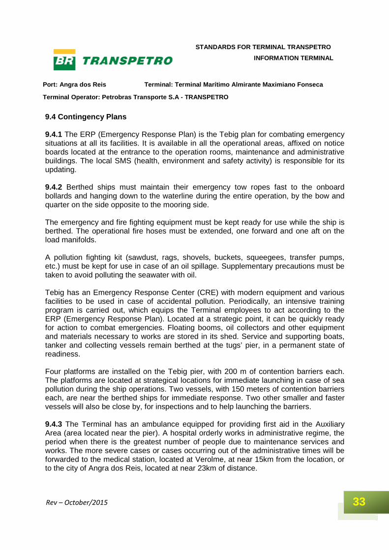
Incidents within the Tebig Port / Terminal Area
Incident type Organization Other organizations involved
Collision on the channel Harbor Master Civil Defense TRANSPETRO
Vessel running aground
Harbor Master Civil Defense TRANSPETRO
Collision at the Berth Harbor Master TRANSPETRO Civil Defense
Vessel Sinking Harbor Master Civil Defense Fire Department TRANSPETRO
Fire aboard Ship Ship TRANSPETRO Fire Department Civil Defense Harbor Master
Fire in the Berth TRANSPETRO Fire Department Civil Defense Harbor Master
Pollution TRANSPETRO or Ship Harbor Master INEA IBAMA
Port: Angra dos Reis Terminal: Terminal Marítimo Al mirante Maximiano Fonseca
Terminal Operator: Petrobras Transporte S.A - TRANS PETRO
33
STANDARDS FOR TERMINAL TRANSPETRO
INFORMATION TERMINAL
Rev – October/2015
9.4 Contingency Plans 9.4.1 The ERP (Emergency Response Plan) is the Tebig plan for combating emergency situations at all its facilities. It is available in all the operational areas, affixed on notice boards located at the entrance to the operation rooms, maintenance and administrative buildings. The local SMS (health, environment and safety activity) is responsible for its updating. 9.4.2 Berthed ships must maintain their emergency tow ropes fast to the onboard bollards and hanging down to the waterline during the entire operation, by the bow and quarter on the side opposite to the mooring side. The emergency and fire fighting equipment must be kept ready for use while the ship is berthed. The operational fire hoses must be extended, one forward and one aft on the load manifolds. A pollution fighting kit (sawdust, rags, shovels, buckets, squeegees, transfer pumps, etc.) must be kept for use in case of an oil spillage. Supplementary precautions must be taken to avoid polluting the seawater with oil. Tebig has an Emergency Response Center (CRE) with modern equipment and various facilities to be used in case of accidental pollution. Periodically, an intensive training program is carried out, which equips the Terminal employees to act according to the ERP (Emergency Response Plan). Located at a strategic point, it can be quickly ready for action to combat emergencies. Floating booms, oil collectors and other equipment and materials necessary to works are stored in its shed. Service and supporting boats, tanker and collecting vessels remain berthed at the tugs’ pier, in a permanent state of readiness. Four platforms are installed on the Tebig pier, with 200 m of contention barriers each. The platforms are located at strategical locations for immediate launching in case of sea pollution during the ship operations. Two vessels, with 150 meters of contention barriers each, are near the berthed ships for immediate response. Two other smaller and faster vessels will also be close by, for inspections and to help launching the barriers. 9.4.3 The Terminal has an ambulance equipped for providing first aid in the Auxiliary Area (area located near the pier). A hospital orderly works in administrative regime, the period when there is the greatest number of people due to maintenance services and works. The more severe cases or cases occurring out of the administrative times will be forwarded to the medical station, located at Verolme, at near 15km from the location, or to the city of Angra dos Reis, located at near 23km of distance.
Port: Angra dos Reis Terminal: Terminal Marítimo Al mirante Maximiano Fonseca
Terminal Operator: Petrobras Transporte S.A - TRANS PETRO
34
STANDARDS FOR TERMINAL TRANSPETRO
INFORMATION TERMINAL
Rev – October/2015
9.5 Public Resources for Combating Emergencies At the Port of Angra dos Reis, only Transpetro – via Tebig and other operational units, called into action by the Local Emergency Plan – have resources that may be used for mitigating sea pollution events. For other emergencies, the public organizations offer resources they are destined to. 9.5.1 Local Emergency Services The Fire Department, Civil Defense, Police and the hospital unit in Angra dos Reis have the appropriate resources, and are called into action according to the Table in the section 9.1. 9.5.2 Mutual support plans The institutions listed below participate in the PAM (Mutual Assistance Plan of the Green Coast (Costa Verde)): Their resources are available as priorly agreed in this plan: > Fire Department (Military Police) of the State of Rio de Janeiro > Transpetro/Tebig > MBR (Minerações Brasileiras Reunidas) > Angra dos Reis City Administration (Civil Defense) > ELETRONUCLEAR > Mangaratiba City Hall > INEA > Hotel Portobello > Hotel Portogalo > Club Med > Federal Highway Police > Estaleiro Brasfels > Vale >Viação Senhor do Bonfim > GRAM – Grupo de Radiomadores de Manbucaba > TRANSMAR – Transporte Marítimos de Angra dos Reis 9.6 Combating Oil Spills The following sub-items describe the resources available for combating pollution in the areas adjacent to the Terminal.
Port: Angra dos Reis Terminal: Terminal Marítimo Al mirante Maximiano Fonseca
Terminal Operator: Petrobras Transporte S.A - TRANS PETRO
35
STANDARDS FOR TERMINAL TRANSPETRO
INFORMATION TERMINAL
Rev – October/2015
9.6.1 Combat Capacity of the Terminal The resources available at the Terminal for combating oil spillage situations are listed in the ERP, which is available in all the administrative, operational and maintenance areas of TEBIG. 9.6.2 Combat Capacity of the Environment Agency The Environmental Agency of Angra dos Reis does not have resources for combating oil spillage in the sea. 9.6.3 Resources available from the Mutual Support P lans at other Terminals The resources available at other Transpetro Terminals for providing assistance to emergency pollution situations occurring at the Terminal surroundings, are listed in the local ERP. 9.7 Combating a Large Scale Incident The ERP at TEBIG lists those actions and those responsible for every type of event expected to occur within its unit, pipelines or vessels, and which involve third parties. For events not foreseen in this document, TRANSPETRO/PETROBRAS will provide all the national or international resources within its reach. 10 CONTACTS The following tables indicate the organization, title of the person in charge, telephone, fax, e-mail and radio channel/frequencies. 10.1 Terminal
Location Contact Telephone Fax Channels VHF/UHF
Call Conversation
Berths P-1 and P-2 Operator 55 24 - 33665246 - x - 16 09
Control Center Operator 55 24 33665445 55 24 33617331
- x - 16 09
Shift Supervisor Supervisor 55 24 - 33665283 - x - - x - Land 02
Security (SMS) Supervisor 55 24 – 33665319 - x - - x - Land 06

Port: Angra dos Reis Terminal: Terminal Marítimo Al mirante Maximiano Fonseca
Terminal Operator: Petrobras Transporte S.A - TRANS PETRO
36
STANDARDS FOR TERMINAL TRANSPETRO
INFORMATION TERMINAL
Rev – October/2015
10.2 Port Services
Organizatio
Contact
Telephone Fax E-mail
Channels VHF/UHF
Call Conversation
Harbor Master Officer of
duty (55 24)33650365 (55 24)33644595
(55 24)33653355 secom@dlangr.
mar.mil.br- 16 - x -
Associatio Pilotticos
Dispatcher (55 21)27891278 (55 21)27891344
- x - atalaiamangaratiba@praticagem-
rj.org.br 16 13
Tugs Agency As per 10.3 As per 10.3 - x - 16 13
10.3 Selected Navigation Agents and Suppliers
Company Business Telephone Fax E-mail Channels VHF/UHF
Call Conversation
ISS Agent (55 24)34213750 (55 24)92592529
(55 24)33644209 herton.jones@iss-
shipping.com 16 08
TERRA ENERGY
Agent (55 24)33655655 (55 24)33655127 teamangra@teamangra
.com.br - X - - X -
10.4 Local Authorities, State and National Agencies The table in section 9.1 shows the list of these authorities and how to contact them.
Port: Angra dos Reis Terminal: Terminal Marítimo Al mirante Maximiano Fonseca
Terminal Operator: Petrobras Transporte S.A - TRANS PETRO
37
STANDARDS FOR TERMINAL TRANSPETRO
INFORMATION TERMINAL
Rev – October/2015
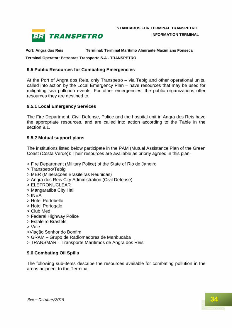
APPENDICES A – Location of the Tebig Pier
Port: Angra dos Reis Terminal: Terminal Marítimo Al mirante Maximiano Fonseca
Terminal Operator: Petrobras Transporte S.A - TRANS PETRO
38
STANDARDS FOR TERMINAL TRANSPETRO
INFORMATION TERMINAL
Rev – October/2015
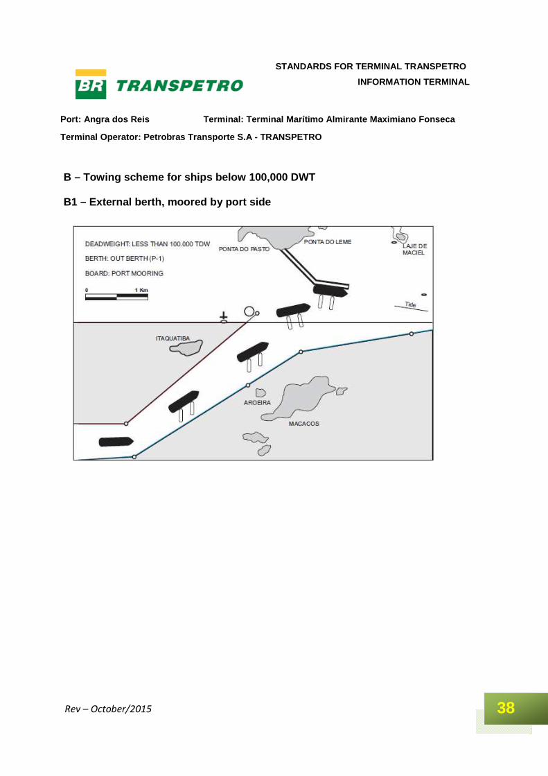
B – Towing scheme for ships below 100,000 DWT B1 – External berth, moored by port side
Port: Angra dos Reis Terminal: Terminal Marítimo Al mirante Maximiano Fonseca
Terminal Operator: Petrobras Transporte S.A - TRANS PETRO
39
STANDARDS FOR TERMINAL TRANSPETRO
INFORMATION TERMINAL
Rev – October/2015
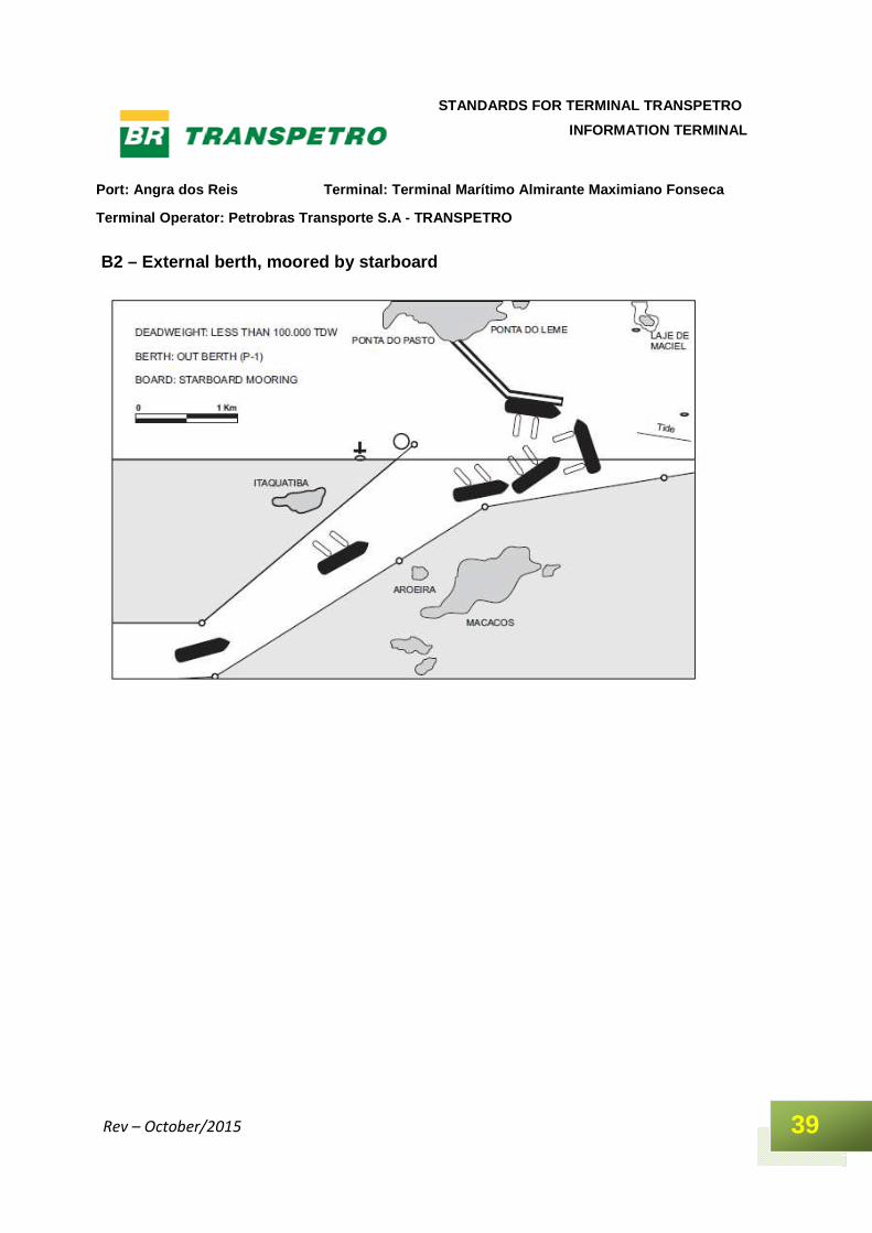
B2 – External berth, moored by starboard
Port: Angra dos Reis Terminal: Terminal Marítimo Al mirante Maximiano Fonseca
Terminal Operator: Petrobras Transporte S.A - TRANS PETRO
40
STANDARDS FOR TERMINAL TRANSPETRO
INFORMATION TERMINAL
Rev – October/2015
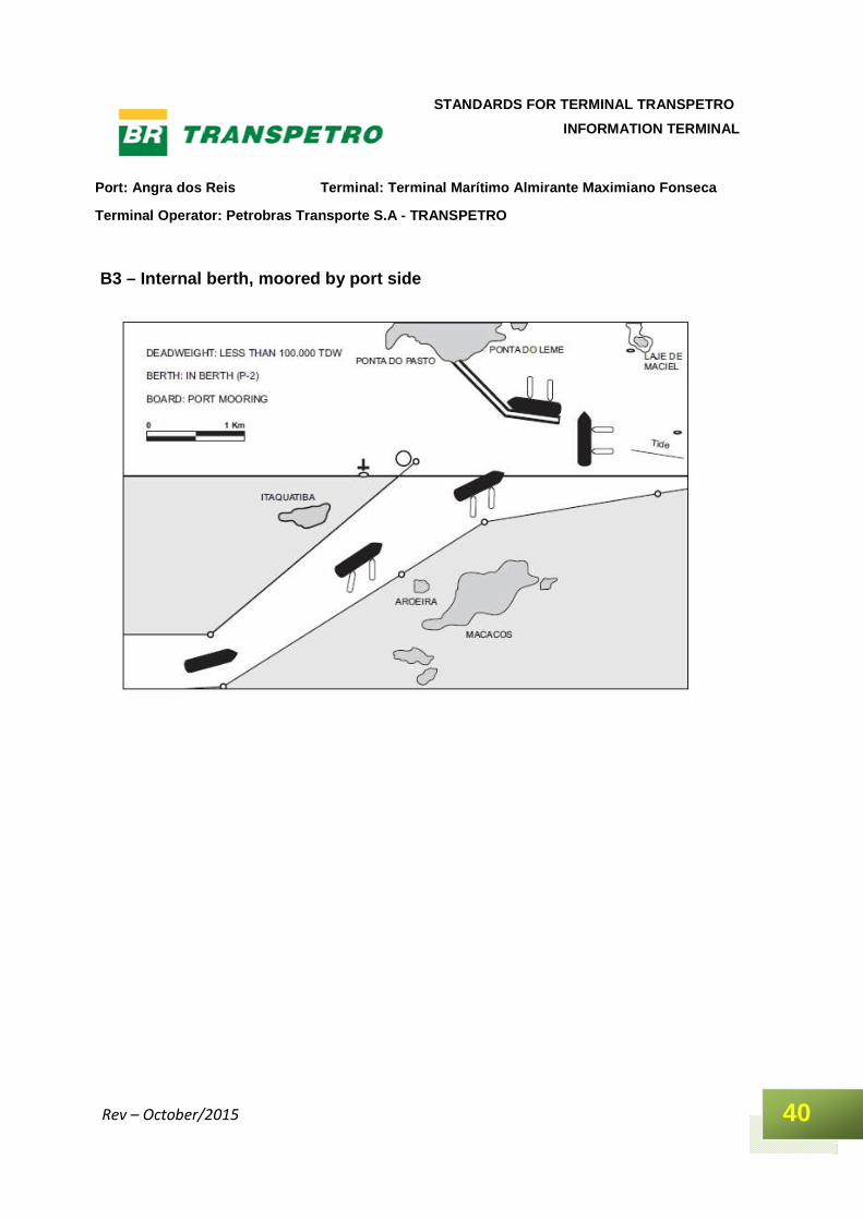
B3 – Internal berth, moored by port side
Port: Angra dos Reis Terminal: Terminal Marítimo Al mirante Maximiano Fonseca
Terminal Operator: Petrobras Transporte S.A - TRANS PETRO
41
STANDARDS FOR TERMINAL TRANSPETRO
INFORMATION TERMINAL
Rev – October/2015
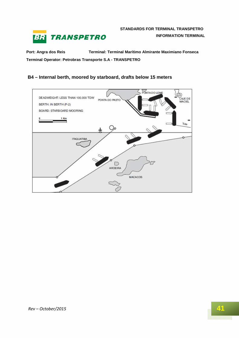
B4 – Internal berth, moored by starboard, drafts be low 15 meters
Port: Angra dos Reis Terminal: Terminal Marítimo Al mirante Maximiano Fonseca
Terminal Operator: Petrobras Transporte S.A - TRANS PETRO
42
STANDARDS FOR TERMINAL TRANSPETRO
INFORMATION TERMINAL
Rev – October/2015
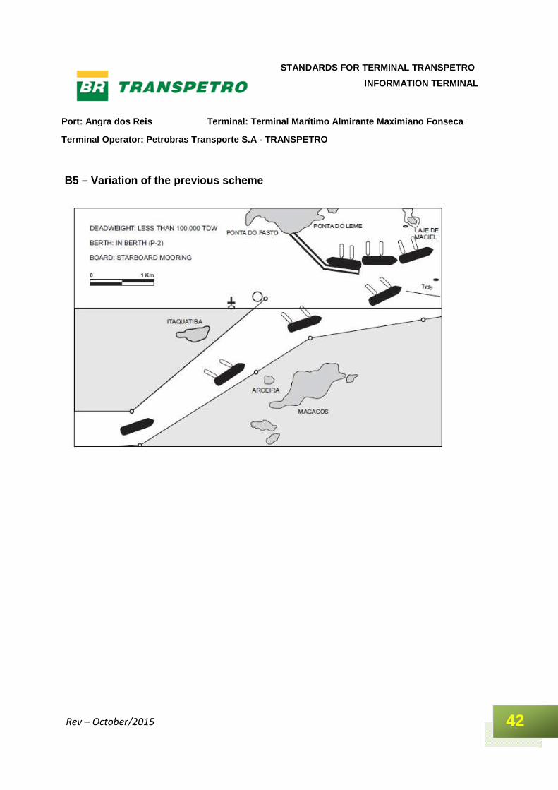
B5 – Variation of the previous scheme
Port: Angra dos Reis Terminal: Terminal Marítimo Al mirante Maximiano Fonseca
Terminal Operator: Petrobras Transporte S.A - TRANS PETRO
43
STANDARDS FOR TERMINAL TRANSPETRO
INFORMATION TERMINAL
Rev – October/2015
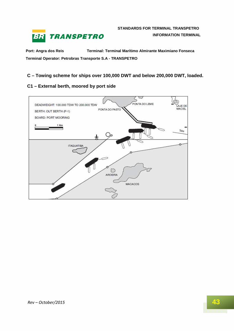
C – Towing scheme for ships over 100,000 DWT and be low 200,000 DWT, loaded. C1 – External berth, moored by port side

Port: Angra dos Reis Terminal: Terminal Marítimo Al mirante Maximiano Fonseca
Terminal Operator: Petrobras Transporte S.A - TRANS PETRO
44
STANDARDS FOR TERMINAL TRANSPETRO
INFORMATION TERMINAL
Rev – October/2015
C2 – External berth, moored by starboard
Port: Angra dos Reis Terminal: Terminal Marítimo Al mirante Maximiano Fonseca
Terminal Operator: Petrobras Transporte S.A - TRANS PETRO
45
STANDARDS FOR TERMINAL TRANSPETRO
INFORMATION TERMINAL
Rev – October/2015
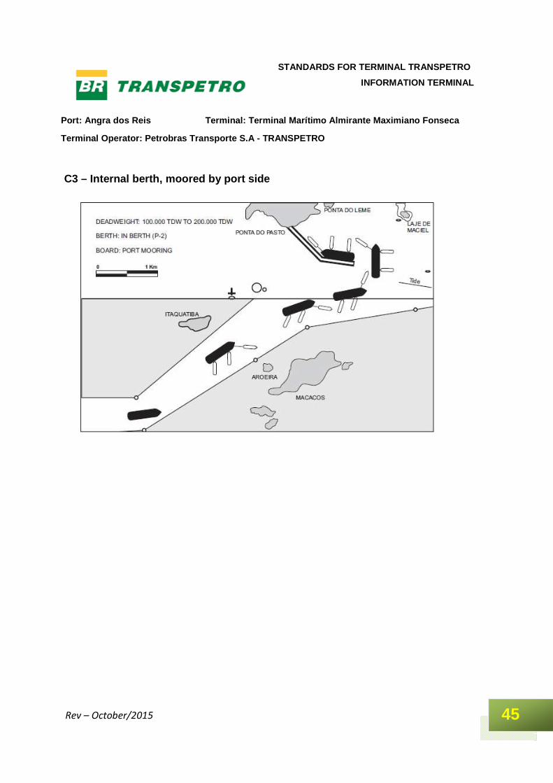
C3 – Internal berth, moored by port side
Port: Angra dos Reis Terminal: Terminal Marítimo Al mirante Maximiano Fonseca
Terminal Operator: Petrobras Transporte S.A - TRANS PETRO
46
STANDARDS FOR TERMINAL TRANSPETRO
INFORMATION TERMINAL
Rev – October/2015
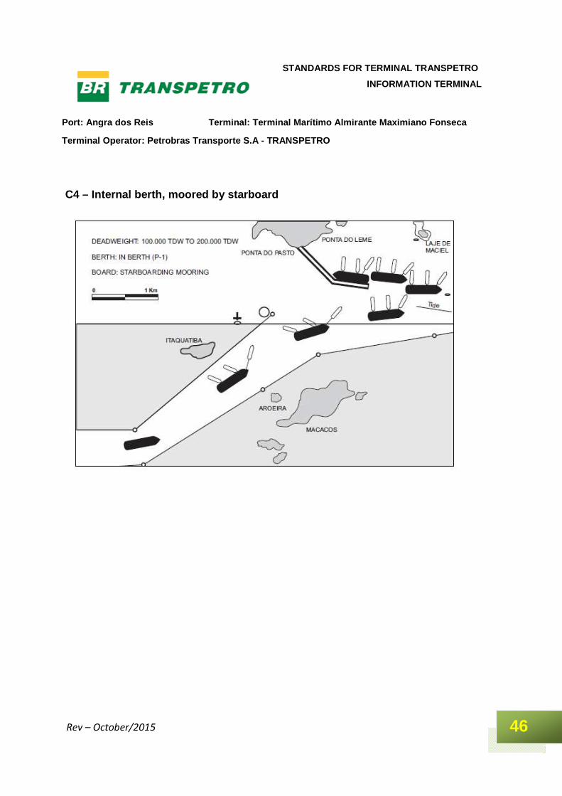
C4 – Internal berth, moored by starboard
Port: Angra dos Reis Terminal: Terminal Marítimo Al mirante Maximiano Fonseca
Terminal Operator: Petrobras Transporte S.A - TRANS PETRO
47
STANDARDS FOR TERMINAL TRANSPETRO
INFORMATION TERMINAL
Rev – October/2015
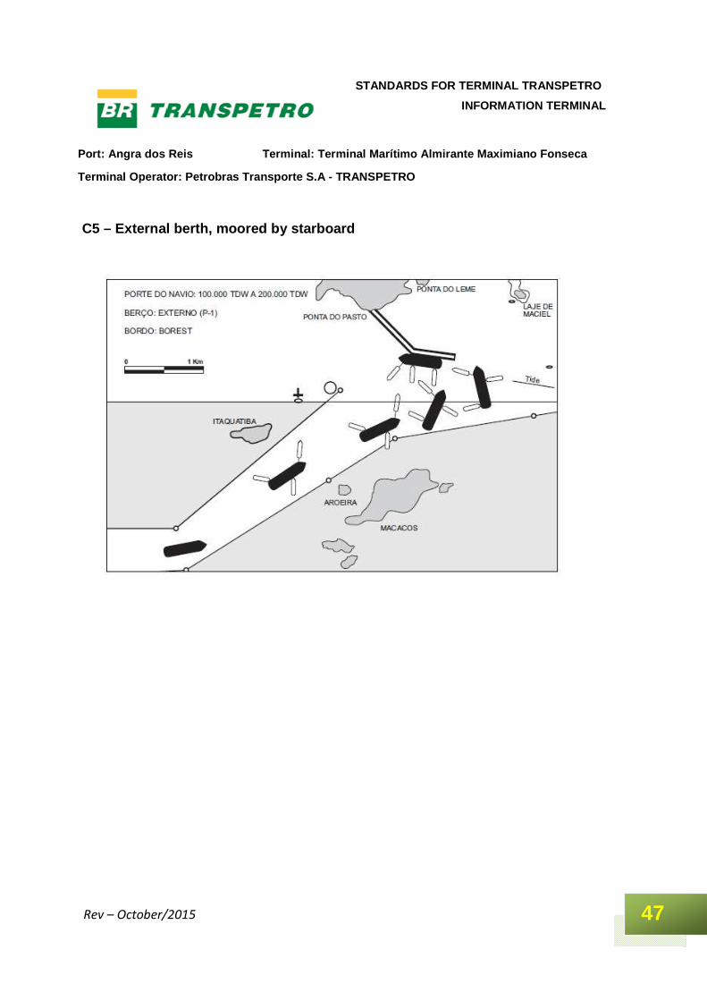
C5 – External berth, moored by starboard
Port: Angra dos Reis Terminal: Terminal Marítimo Al mirante Maximiano Fonseca
Terminal Operator: Petrobras Transporte S.A - TRANS PETRO
48
STANDARDS FOR TERMINAL TRANSPETRO
INFORMATION TERMINAL
Rev – October/2015
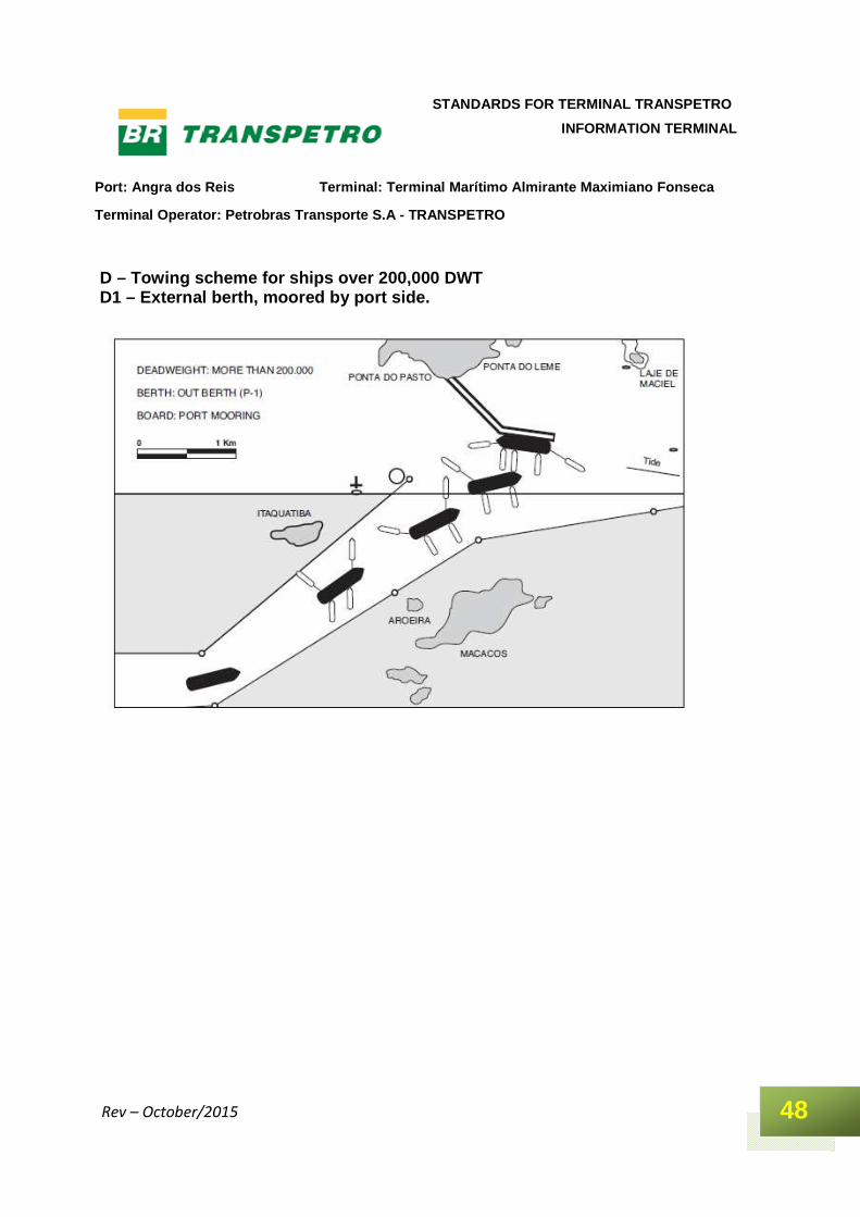
D – Towing scheme for ships over 200,000 DWT D1 – External berth, moored by port side.
Port: Angra dos Reis Terminal: Terminal Marítimo Al mirante Maximiano Fonseca
Terminal Operator: Petrobras Transporte S.A - TRANS PETRO
49
STANDARDS FOR TERMINAL TRANSPETRO
INFORMATION TERMINAL
Rev – October/2015
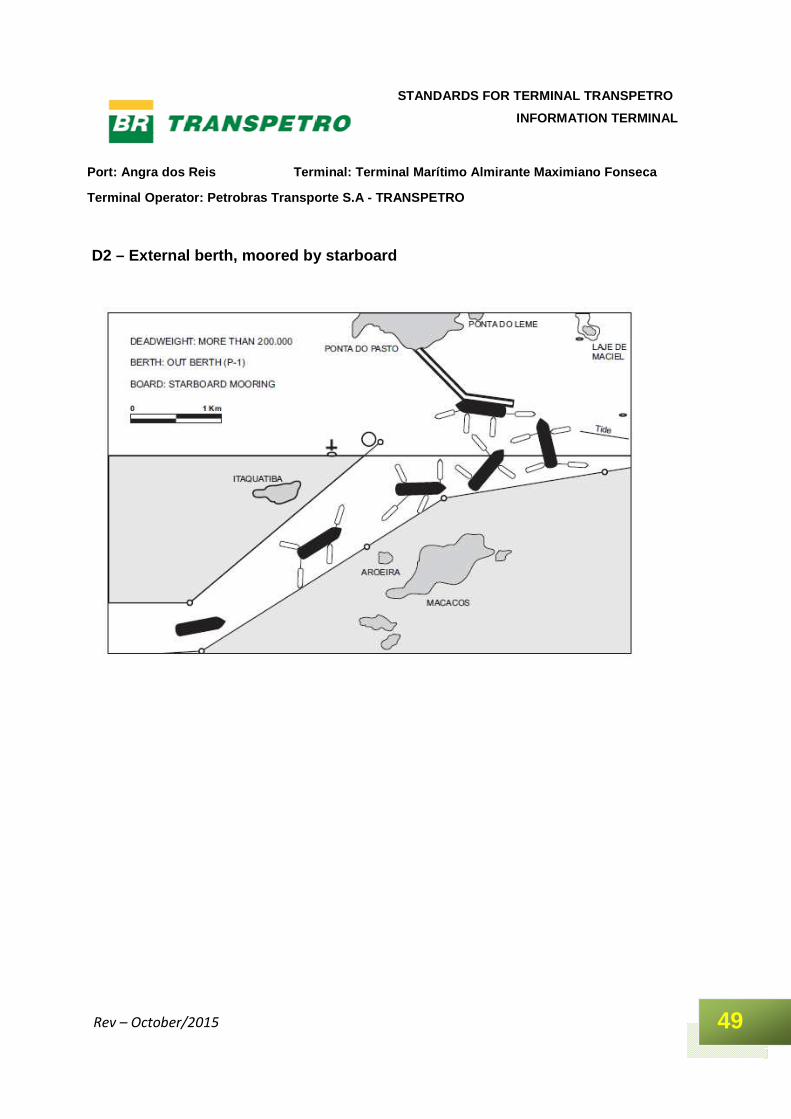
D2 – External berth, moored by starboard
Port: Angra dos Reis Terminal: Terminal Marítimo Al mirante Maximiano Fonseca
Terminal Operator: Petrobras Transporte S.A - TRANS PETRO
50
STANDARDS FOR TERMINAL TRANSPETRO
INFORMATION TERMINAL
Rev – October/2015
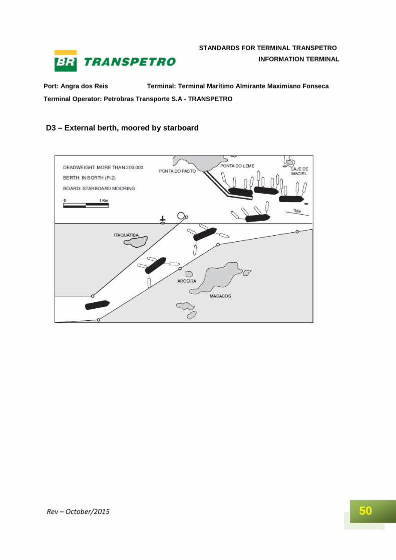
D3 – External berth, moored by starboard
Port: Angra dos Reis Terminal: Terminal Marítimo Al mirante Maximiano Fonseca
Terminal Operator: Petrobras Transporte S.A - TRANS PETRO
51
STANDARDS FOR TERMINAL TRANSPETRO
INFORMATION TERMINAL
Rev – October/2015
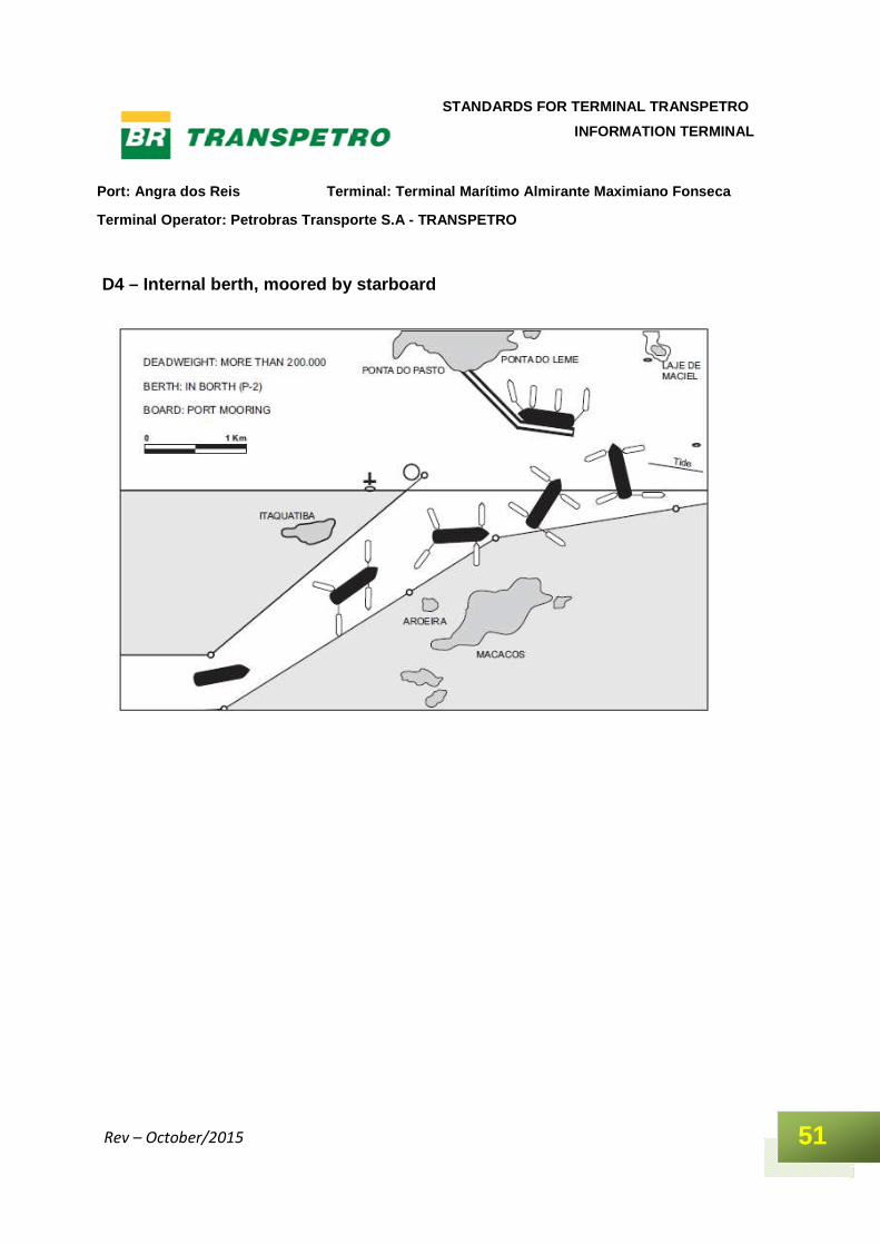
D4 – Internal berth, moored by starboard
Port: Angra dos Reis Terminal: Terminal Marítimo Al mirante Maximiano Fonseca
Terminal Operator: Petrobras Transporte S.A - TRANS PETRO
52
STANDARDS FOR TERMINAL TRANSPETRO
INFORMATION TERMINAL
Rev – October/2015
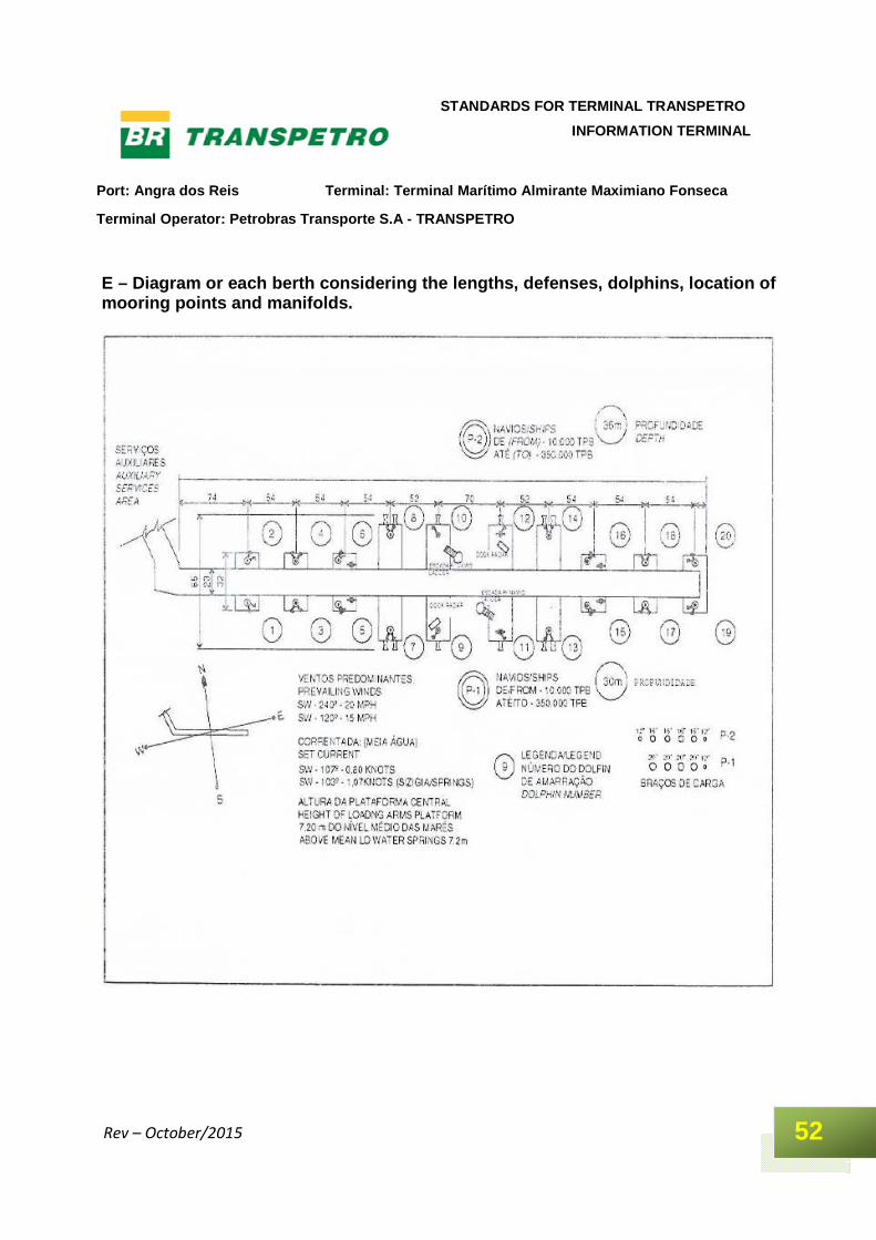
E – Diagram or each berth considering the lengths, defenses, dolphins, location of mooring points and manifolds.
Port: Angra dos Reis Terminal: Terminal Marítimo Al mirante Maximiano Fonseca
Terminal Operator: Petrobras Transporte S.A - TRANS PETRO
53
STANDARDS FOR TERMINAL TRANSPETRO
INFORMATION TERMINAL
Rev – October/2015
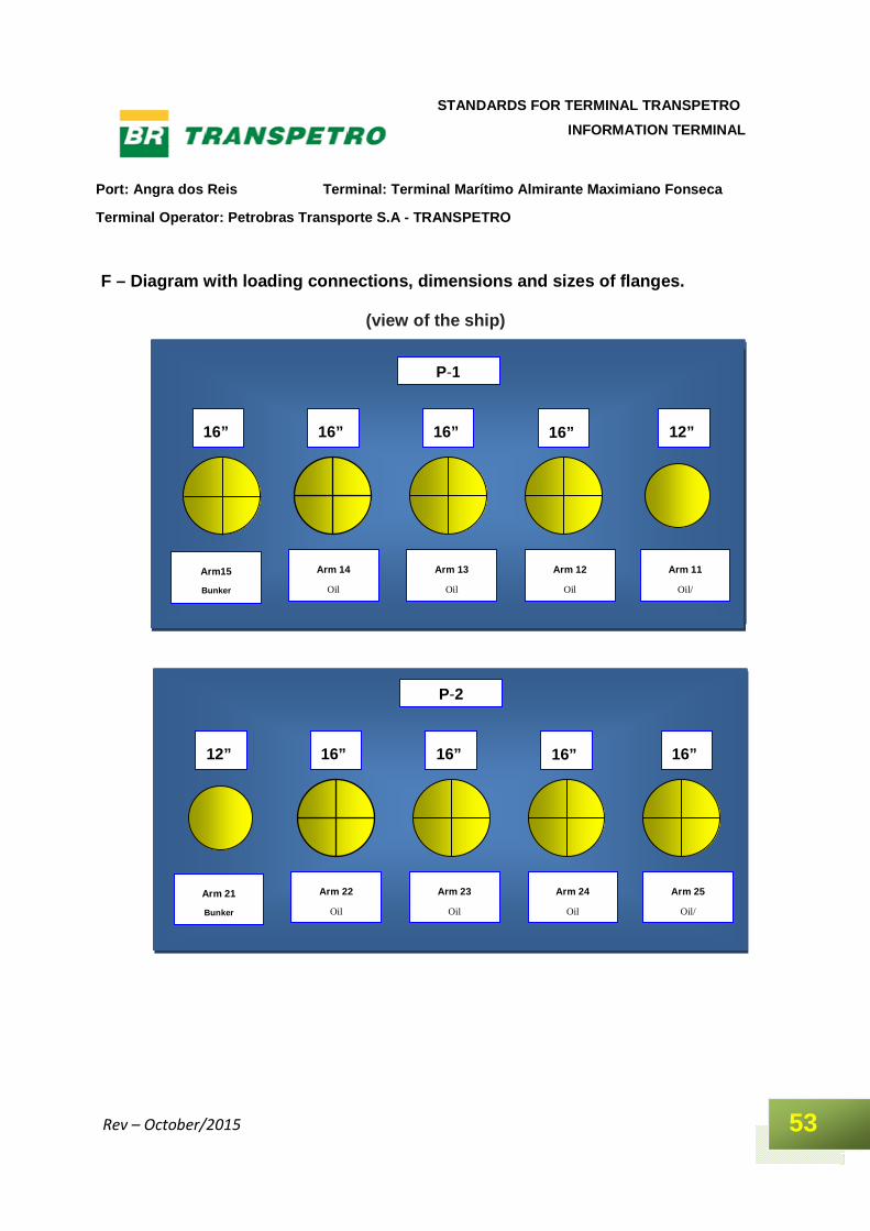
F – Diagram with loading connections, dimensions an d sizes of flanges.
(view of the ship)
Arm 21
Bunker Arm 22
Oil
Arm 25
Oil/
16””
16””
16””
16” 12””
P-2
Arm 23
Oil
Arm 24
Oil
Braço15
Bunker Braço 14
petróleo
Braço 11
Petróleo/
12””
16””
16””
16” 16””
P-1
Braço 13
petróleo
Braço 12
petróleo Arm15
Bunker Arm 14
Oil
Arm 11
Oil/
12””
16””
16””
16” 16””
P-1
Arm 13
Oil
Arm 12
Oil
Port: Angra dos Reis Terminal: Terminal Marítimo Al mirante Maximiano Fonseca
Terminal Operator: Petrobras Transporte S.A - TRANS PETRO
54
STANDARDS FOR TERMINAL TRANSPETRO
INFORMATION TERMINAL
Rev – October/2015
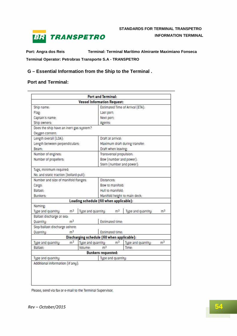
G – Essential Information from the Ship to the Term inal . Port and Terminal:
Port: Angra dos Reis Terminal: Terminal Marítimo Al mirante Maximiano Fonseca
Terminal Operator: Petrobras Transporte S.A - TRANS PETRO
55
STANDARDS FOR TERMINAL TRANSPETRO
INFORMATION TERMINAL
Rev – October/2015
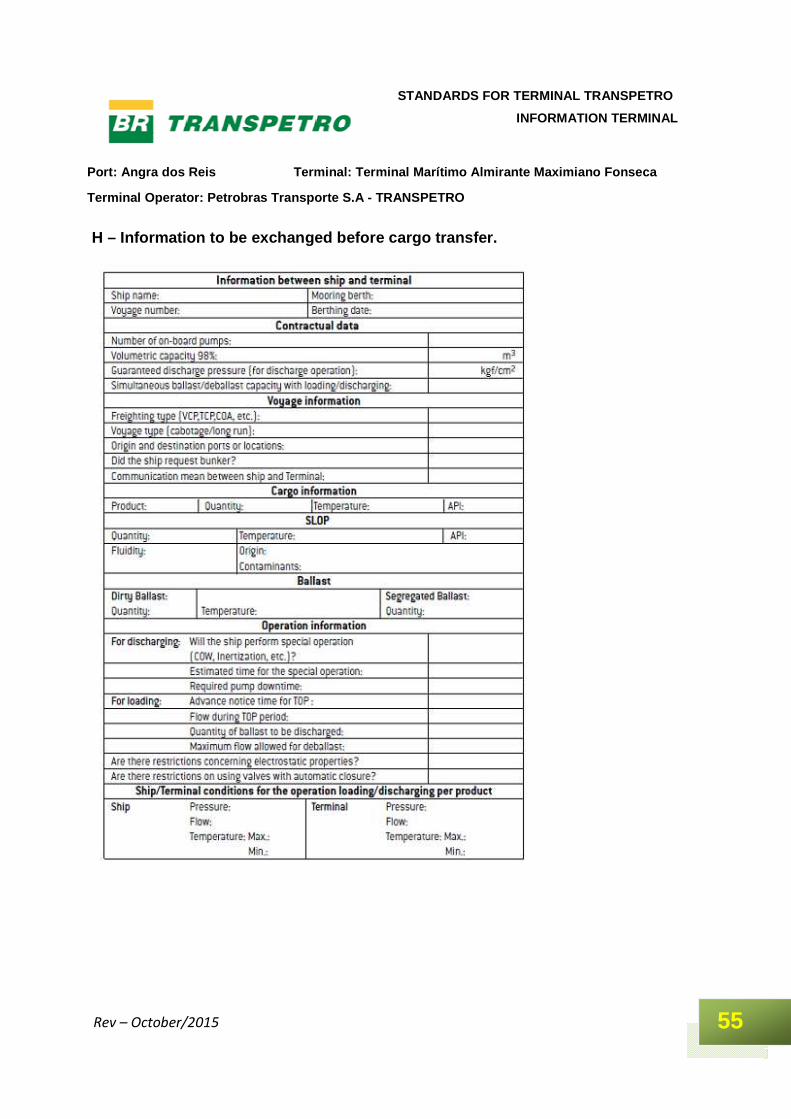
H – Information to be exchanged before cargo transf er.