Embed Size (px)
Citation preview
EnvironmentThe Corps
VOLUME 15, ISSUE 3 JULY 2014
See Park, Page 4
Restoring Chicago park designed by nation’s foremost parkmaker
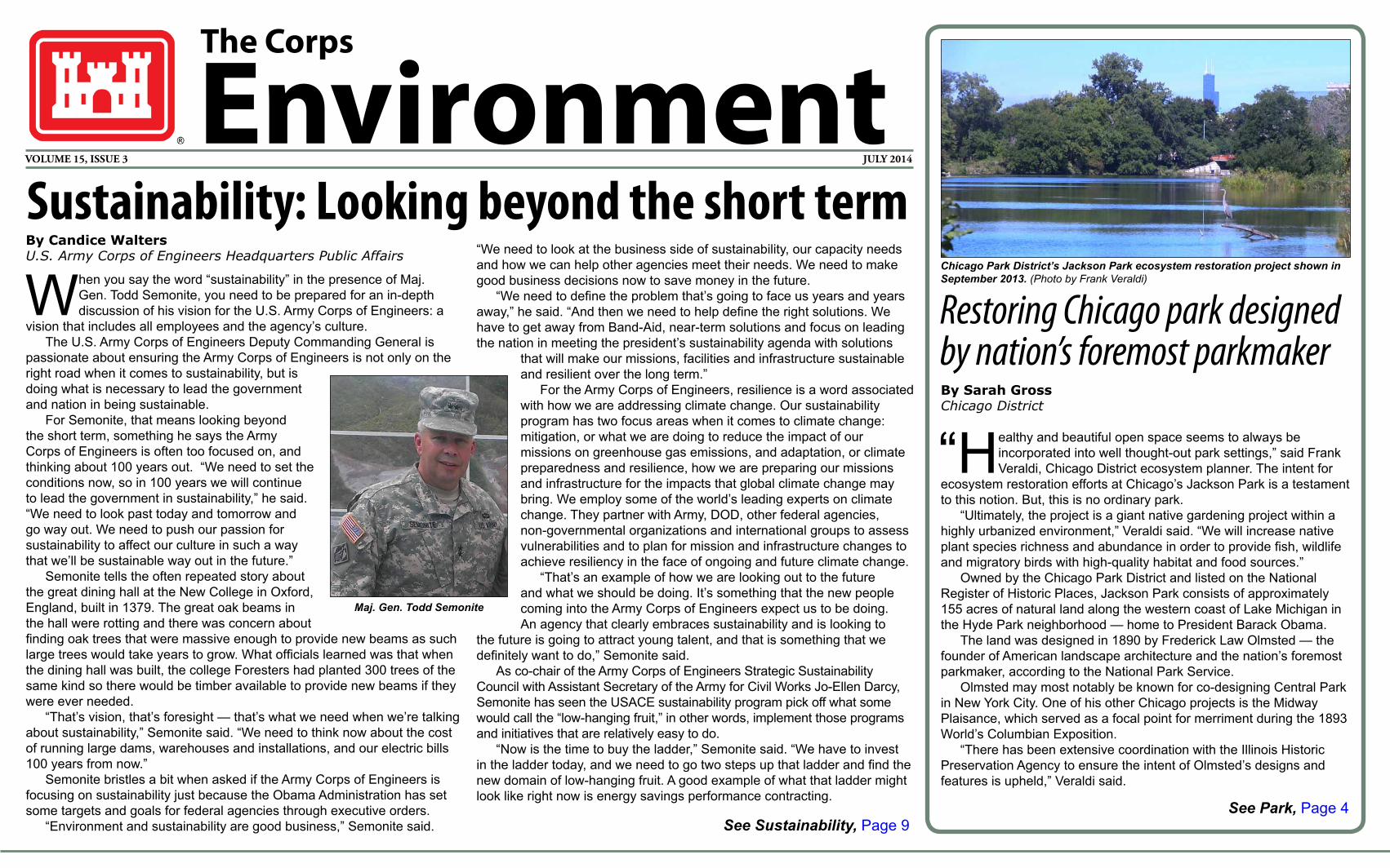
Chicago Park District’s Jackson Park ecosystem restoration project shown in September 2013. (Photo by Frank Veraldi)
Sustainability: Looking beyond the short term
See Sustainability, Page 9
By Sarah GrossChicago District
“Healthy and beautiful open space seems to always be incorporated into well thought-out park settings,” said Frank Veraldi, Chicago District ecosystem planner. The intent for
ecosystem restoration efforts at Chicago’s Jackson Park is a testament to this notion. But, this is no ordinary park.
“Ultimately, the project is a giant native gardening project within a highly urbanized environment,” Veraldi said. “We will increase native plant species richness and abundance in order to provide fish, wildlife and migratory birds with high-quality habitat and food sources.”
Owned by the Chicago Park District and listed on the National Register of Historic Places, Jackson Park consists of approximately 155 acres of natural land along the western coast of Lake Michigan in the Hyde Park neighborhood — home to President Barack Obama.
The land was designed in 1890 by Frederick Law Olmsted — the founder of American landscape architecture and the nation’s foremost parkmaker, according to the National Park Service.
Olmsted may most notably be known for co-designing Central Park in New York City. One of his other Chicago projects is the Midway Plaisance, which served as a focal point for merriment during the 1893 World’s Columbian Exposition.
“There has been extensive coordination with the Illinois Historic Preservation Agency to ensure the intent of Olmsted’s designs and features is upheld,” Veraldi said.
By Candice WaltersU.S. Army Corps of Engineers Headquarters Public Affairs
When you say the word “sustainability” in the presence of Maj. Gen. Todd Semonite, you need to be prepared for an in-depth discussion of his vision for the U.S. Army Corps of Engineers: a
vision that includes all employees and the agency’s culture. The U.S. Army Corps of Engineers Deputy Commanding General is
passionate about ensuring the Army Corps of Engineers is not only on the right road when it comes to sustainability, but is doing what is necessary to lead the government and nation in being sustainable.
For Semonite, that means looking beyond the short term, something he says the Army Corps of Engineers is often too focused on, and thinking about 100 years out. “We need to set the conditions now, so in 100 years we will continue to lead the government in sustainability,” he said. “We need to look past today and tomorrow and go way out. We need to push our passion for sustainability to affect our culture in such a way that we’ll be sustainable way out in the future.”
Semonite tells the often repeated story about the great dining hall at the New College in Oxford, England, built in 1379. The great oak beams in the hall were rotting and there was concern about finding oak trees that were massive enough to provide new beams as such large trees would take years to grow. What officials learned was that when the dining hall was built, the college Foresters had planted 300 trees of the same kind so there would be timber available to provide new beams if they were ever needed.
“That’s vision, that’s foresight — that’s what we need when we’re talking about sustainability,” Semonite said. “We need to think now about the cost of running large dams, warehouses and installations, and our electric bills 100 years from now.”
Semonite bristles a bit when asked if the Army Corps of Engineers is focusing on sustainability just because the Obama Administration has set some targets and goals for federal agencies through executive orders.
“Environment and sustainability are good business,” Semonite said.
“We need to look at the business side of sustainability, our capacity needs and how we can help other agencies meet their needs. We need to make good business decisions now to save money in the future.
“We need to define the problem that’s going to face us years and years away,” he said. “And then we need to help define the right solutions. We have to get away from Band-Aid, near-term solutions and focus on leading the nation in meeting the president’s sustainability agenda with solutions
that will make our missions, facilities and infrastructure sustainable and resilient over the long term.”
For the Army Corps of Engineers, resilience is a word associated with how we are addressing climate change. Our sustainability program has two focus areas when it comes to climate change: mitigation, or what we are doing to reduce the impact of our missions on greenhouse gas emissions, and adaptation, or climate preparedness and resilience, how we are preparing our missions and infrastructure for the impacts that global climate change may bring. We employ some of the world’s leading experts on climate change. They partner with Army, DOD, other federal agencies, non-governmental organizations and international groups to assess vulnerabilities and to plan for mission and infrastructure changes to achieve resiliency in the face of ongoing and future climate change.
“That’s an example of how we are looking out to the future and what we should be doing. It’s something that the new people coming into the Army Corps of Engineers expect us to be doing. An agency that clearly embraces sustainability and is looking to
the future is going to attract young talent, and that is something that we definitely want to do,” Semonite said.
As co-chair of the Army Corps of Engineers Strategic Sustainability Council with Assistant Secretary of the Army for Civil Works Jo-Ellen Darcy, Semonite has seen the USACE sustainability program pick off what some would call the “low-hanging fruit,” in other words, implement those programs and initiatives that are relatively easy to do.
“Now is the time to buy the ladder,” Semonite said. “We have to invest in the ladder today, and we need to go two steps up that ladder and find the new domain of low-hanging fruit. A good example of what that ladder might look like right now is energy savings performance contracting.
Maj. Gen. Todd Semonite
THE CORPS ENVIRONMENT PAGE 2
SubmissionsThe Corps Environment welcomes submissions. Please send your articles, photos, events, letters or questions to [email protected].
Deadline for submissions:Nov. 15 (January issue)Feb. 15 (April issue)May 15 (July issue)Aug. 15 (October issue)
www.usace.army.mil/Missions/Environmental.aspx
Whenever possible, please enjoy The Corps Environment without using paper.
is an online quarterly produced by the U.S. Army Corps of Engineers as an unofficial newsletter under the provisions of AR 360-1. The purpose of this newsletter is to provide information about Corps environmental actions, issues, policies and technologies. Opinions expressed are not necessarily those of the U.S. Army. Inquiries can be addressed to U.S. Army Corps of Engineers, Attn: CEHNC-PA, P.O. Box 1600, Huntsville, AL 35807-4301. Phone: 256-895-1809.
Lt. Gen. Thomas P. Bostick Commanding General
PublisherW. Curry Graham
Director of Public AffairsKaren Baker
Executive EditorCandice WaltersManaging Editor
Julia BobickEditor
The Corps EnvironmentCONTENTS
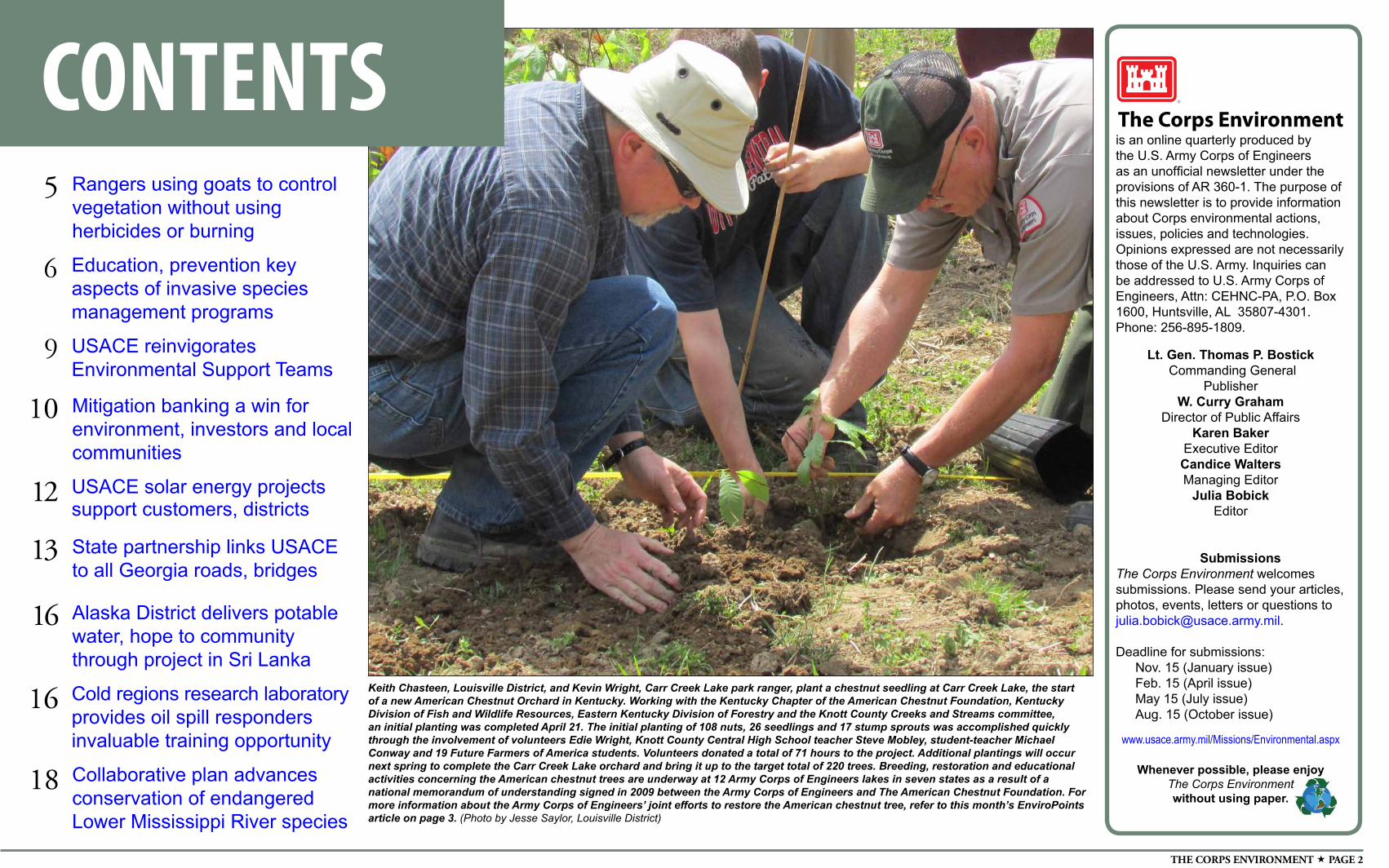
Keith Chasteen, Louisville District, and Kevin Wright, Carr Creek Lake park ranger, plant a chestnut seedling at Carr Creek Lake, the start of a new American Chestnut Orchard in Kentucky. Working with the Kentucky Chapter of the American Chestnut Foundation, Kentucky Division of Fish and Wildlife Resources, Eastern Kentucky Division of Forestry and the Knott County Creeks and Streams committee, an initial planting was completed April 21. The initial planting of 108 nuts, 26 seedlings and 17 stump sprouts was accomplished quickly through the involvement of volunteers Edie Wright, Knott County Central High School teacher Steve Mobley, student-teacher Michael Conway and 19 Future Farmers of America students. Volunteers donated a total of 71 hours to the project. Additional plantings will occur next spring to complete the Carr Creek Lake orchard and bring it up to the target total of 220 trees. Breeding, restoration and educational activities concerning the American chestnut trees are underway at 12 Army Corps of Engineers lakes in seven states as a result of a national memorandum of understanding signed in 2009 between the Army Corps of Engineers and The American Chestnut Foundation. For more information about the Army Corps of Engineers’ joint efforts to restore the American chestnut tree, refer to this month’s EnviroPoints article on page 3. (Photo by Jesse Saylor, Louisville District)
6 Education, prevention key aspects of invasive species management programs
9 USACE reinvigorates Environmental Support Teams
Mitigation banking a win for environment, investors and local communities
10
USACE solar energy projects support customers, districts
12
State partnership links USACE to all Georgia roads, bridges
13
Rangers using goats to control vegetation without using herbicides or burning
5
Alaska District delivers potable water, hope to community through project in Sri Lanka
16
Cold regions research laboratory provides oil spill responders invaluable training opportunity
16
Collaborative plan advances conservation of endangered Lower Mississippi River species
18
JULY 2014 PAGE 3
ENVIROPOINTS
Partnering valuable tool in natural resource management efforts
James R. Hannon Jr.
By James R. Hannon Jr.U.S. Army Corps of Engineers Chief, Operations and Regulatory Division
We have all heard the words before — collaboration, partnerships and working together to find solutions
to the challenges no one agency or group can do on its own. In my years working with the U.S. Army Corps of Engineers and especially as the head of the Operations Division, I can attest to the validity of those words.
“In today’s budgetary climate, partnering is an essential tool that allows the Army Corps of Engineers to effectively manage recreation and environmental resources. Each year, thousands of partner organizations and individuals help us maintain and enhance our nation’s natural resources through activities such as wildlife protection, habitat improvements, restoration projects, recreational facility enhancements, education and outreach, and much more,” said Mary Coulombe, Army Corps of Engineers Natural Resource Management chief.
“In fiscal year 2013, more than 1,000 partners contributed a total value of more than $50.7 million, which is an additional 14 percent above the recreation and environmental stewardship budgets,” added Heather Burke, the national partnership program manager. “Volunteer time provided by partners contributed the equivalent of 147 full-time equivalents. Those numbers further equate to a lot of work that aids natural resource staff in accomplishing their daily duties and meeting the needs of the public.”
For the Natural Resources Management community, it’s easy to see how valuable partnerships are, both in terms of actual dollar value and purpose. The partners range from other federal agencies such as the U.S. Fish and Wildlife Service and U.S. Geological Survey to the Girl Scouts of the
United States of America, the National Wild Turkey Association and National Audubon Society. And the diversity is reflected in the value of those partnerships — ranging from 25 partnerships with the Student Conservation Association valued at more than $1.8 million to two partnerships with the Boy Scouts of America valued at $200 and everything in between.
While the value of the partnerships is important, the fact that these organizations want to be part of the Army Corps of Engineers recreation areas demonstrates that they believe they can benefit from the resources the areas offer, whether that be a place for education and outreach or a location that is conducive to protecting a habitat for an endangered species.
That is the case with one partnership taking root at a number of our recreation areas. The Army Corps of Engineers and The American Chestnut Foundation (TACF) have formed a partnership that is helping the foundation restore the American chestnut tree with joint projects in seven states: Massachusetts, Pennsylvania, West Virginia, Kentucky, Virginia, Georgia and Missouri.
Retired Maj. Gen. Merdith “Bo” Temple signed a national memorandum of understanding with the foundation in December 2009 that is guiding the two organizations’ respective efforts to work cooperatively to restore the American chestnut. The agreement is facilitating the breeding, restoration and educational activities concerning the American chestnut trees at 12 different Army Corps of Engineers lakes that provide critical long-term maintenance and care of the orchards.
The American chestnut once made up a quarter of the trees in Appalachia and was known as the King of the Forest and the Redwoods of the East Coast. It was an essential component of the entire U.S. ecosystem and was valued for its timber and nuts. However, a blight brought into the
country on imported Asian chestnut trees practically wiped out the species in the early 1900s.
Efforts now are underway to restore the tree to forests by cross-breeding American chestnut trees with the blight-resistant Chinese chestnut.
Through the memorandum, one notable initiative has been the USACE headquarters handshake partnership program, which has provided $71,000 in funding at Raystown and Shenango
lakes in Pennsylvania, Allatoona Lake in Georgia, and Carr Creek Lake in Kentucky. Local USACE districts and other partners matched that money for a total of $410,000 in American chestnut-specific funding.
“This is one of the most exciting and rewarding projects for our staff and visitors at these lakes because in most species restoration efforts, only a select few biologists can be directly involved. However, each volunteer and participant in this effort gets to hold and plant an American chestnut tree,” said Jeff Krause, USACE national program manager for environmental stewardship.
By establishing orchards in our Army Corps of Engineers recreation areas, we are helping The American Chestnut Foundation in its efforts to plant 1 million trees. The goal is to introduce blight-resistant chestnut trees to the eastern forests of the United States through a multi-faceted approach.
Our project areas are attractive to the foundation because of four reasons: Many of our projects lie within the Chestnut Range; we have existing interpretive programs that assist in educating the public about the heritage and importance of the American chestnut; we have an excellent volunteer base; and the vast majority of our recreation areas are close to metropolitan areas, thus helping to increase public participation and awareness.
Baltimore District’s Raystown Lake has led the way in promoting the reintroduction of the American chestnut tree at Army Corps of Engineers recreation areas, planting 100 pure American chestnut trees to establish its breeding orchard in 1999. Its existing pure American orchard consists of 80 trees, which has produced more than 4,000 chestnuts each year since 2009. With this success, Raystown Lake has planted two additional breeding orchards and a fourth area testing the restoration success of the most advanced seed. Assistant Secretary of the Army for Civil Works Jo-Ellen Darcy recently assisted in the planting of two advanced chestnuts as part of a trail dedication at the lake.
Knott County Central High School Future Farmers of America Club members, Louisville District personnel, Kentucky Department of Fish and Wildlife Resources, and the Kentucky–TACF breeding coordinator participated in a tree-planting effort April 21 at the district’s Carr Creek Lake (see photo on page 2). Display plantings also have taken place at Louisville and Nashville district projects throughout
Kentucky, including Barren River, Nolin River, Dewey, Grayson and Paintsville lakes, as well as Lake Cumberland.
“It’s exciting for USACE to partner with TACF in the recovery of the American chestnut. Within Kentucky, Corps projects exist in each eco-region where chestnut trees naturally occurred. This provides a wonderful opportunity to support TACF’s breeding program, enhance our environmental stewardship mission, and provide educational and interpretive opportunities for our visitors,” said Gene Dowell, Louisville District chief of operations.
Students from Berry College and volunteers from the Georgia Chapter of The American Chestnut Foundation helped plant hybrid chestnuts at the main orchard at Lake Allatoona March 14. In May, a demonstration orchard at Pittsburgh District’s Shenango River Lake was planted with 48 new trees to complement the lake’s 2013 planting of 200 restoration seedlings.
This flurry of recent activity across multiple states illustrates the strong conservation ethic of our employees at Army Corps of Engineers projects to embrace this historic restoration program. As these seedlings take root and blight resistance strains are bred into them, the hope is that future offspring will repopulate forests throughout the East Coast and the American chestnut will once again take its rightful place as the Redwoods of the East Coast.
It’s just one example of how the Army Corps of Engineers is partnering with other organizations to maintain and enhance our country’s natural resources.
THE CORPS ENVIRONMENT PAGE 4
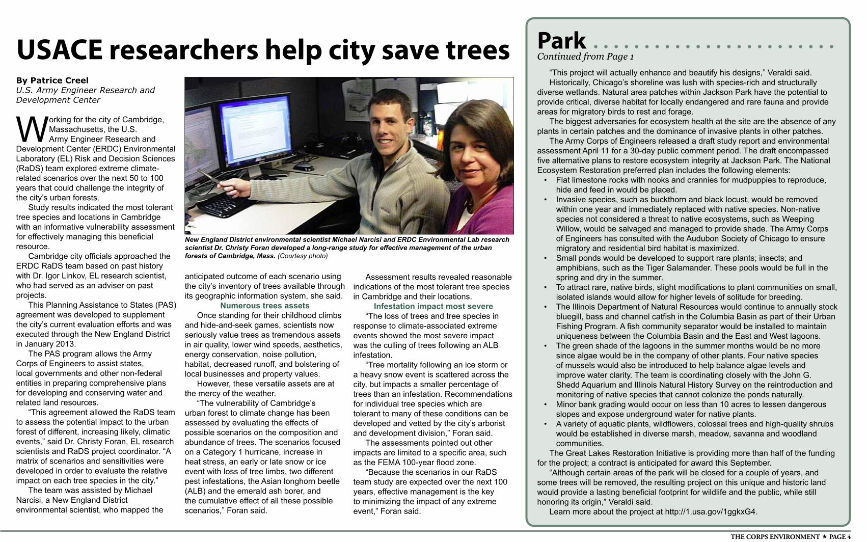
New England District environmental scientist Michael Narcisi and ERDC Environmental Lab research scientist Dr. Christy Foran developed a long-range study for effective management of the urban forests of Cambridge, Mass. (Courtesy photo)
By Patrice CreelU.S. Army Engineer Research and Development Center
Working for the city of Cambridge, Massachusetts, the U.S. Army Engineer Research and
Development Center (ERDC) Environmental Laboratory (EL) Risk and Decision Sciences (RaDS) team explored extreme climate-related scenarios over the next 50 to 100 years that could challenge the integrity of the city’s urban forests.
Study results indicated the most tolerant tree species and locations in Cambridge with an informative vulnerability assessment for effectively managing this beneficial resource.
Cambridge city officials approached the ERDC RaDS team based on past history with Dr. Igor Linkov, EL research scientist, who had served as an adviser on past projects.
This Planning Assistance to States (PAS) agreement was developed to supplement the city’s current evaluation efforts and was executed through the New England District in January 2013.
The PAS program allows the Army Corps of Engineers to assist states, local governments and other non-federal entities in preparing comprehensive plans for developing and conserving water and related land resources.
“This agreement allowed the RaDS team to assess the potential impact to the urban forest of different, increasing likely, climatic events,” said Dr. Christy Foran, EL research scientists and RaDS project coordinator. “A matrix of scenarios and sensitivities were developed in order to evaluate the relative impact on each tree species in the city.”
The team was assisted by Michael Narcisi, a New England District environmental scientist, who mapped the
USACE researchers help city save trees
anticipated outcome of each scenario using the city’s inventory of trees available through its geographic information system, she said.
Numerous trees assetsOnce standing for their childhood climbs
and hide-and-seek games, scientists now seriously value trees as tremendous assets in air quality, lower wind speeds, aesthetics, energy conservation, noise pollution, habitat, decreased runoff, and bolstering of local businesses and property values.
However, these versatile assets are at the mercy of the weather.
“The vulnerability of Cambridge’s urban forest to climate change has been assessed by evaluating the effects of possible scenarios on the composition and abundance of trees. The scenarios focused on a Category 1 hurricane, increase in heat stress, an early or late snow or ice event with loss of tree limbs, two different pest infestations, the Asian longhorn beetle (ALB) and the emerald ash borer, and the cumulative effect of all these possible scenarios,” Foran said.
Assessment results revealed reasonable indications of the most tolerant tree species in Cambridge and their locations.
Infestation impact most severe“The loss of trees and tree species in
response to climate-associated extreme events showed the most severe impact was the culling of trees following an ALB infestation.
“Tree mortality following an ice storm or a heavy snow event is scattered across the city, but impacts a smaller percentage of trees than an infestation. Recommendations for individual tree species which are tolerant to many of these conditions can be developed and vetted by the city’s arborist and development division,” Foran said.
The assessments pointed out other impacts are limited to a specific area, such as the FEMA 100-year flood zone.
“Because the scenarios in our RaDS team study are expected over the next 100 years, effective management is the key to minimizing the impact of any extreme event,” Foran said.
“This project will actually enhance and beautify his designs,” Veraldi said.Historically, Chicago’s shoreline was lush with species-rich and structurally
diverse wetlands. Natural area patches within Jackson Park have the potential to provide critical, diverse habitat for locally endangered and rare fauna and provide areas for migratory birds to rest and forage.
The biggest adversaries for ecosystem health at the site are the absence of any plants in certain patches and the dominance of invasive plants in other patches.
The Army Corps of Engineers released a draft study report and environmental assessment April 11 for a 30-day public comment period. The draft encompassed five alternative plans to restore ecosystem integrity at Jackson Park. The National Ecosystem Restoration preferred plan includes the following elements:
• Flat limestone rocks with nooks and crannies for mudpuppies to reproduce, hide and feed in would be placed.
• Invasive species, such as buckthorn and black locust, would be removed within one year and immediately replaced with native species. Non-native species not considered a threat to native ecosystems, such as Weeping Willow, would be salvaged and managed to provide shade. The Army Corps of Engineers has consulted with the Audubon Society of Chicago to ensure migratory and residential bird habitat is maximized.
• Small ponds would be developed to support rare plants; insects; and amphibians, such as the Tiger Salamander. These pools would be full in the spring and dry in the summer.
• To attract rare, native birds, slight modifications to plant communities on small, isolated islands would allow for higher levels of solitude for breeding.
• The Illinois Department of Natural Resources would continue to annually stock bluegill, bass and channel catfish in the Columbia Basin as part of their Urban Fishing Program. A fish community separator would be installed to maintain uniqueness between the Columbia Basin and the East and West lagoons.
• The green shade of the lagoons in the summer months would be no more since algae would be in the company of other plants. Four native species of mussels would also be introduced to help balance algae levels and improve water clarity. The team is coordinating closely with the John G. Shedd Aquarium and Illinois Natural History Survey on the reintroduction and monitoring of native species that cannot colonize the ponds naturally.
• Minor bank grading would occur on less than 10 acres to lessen dangerous slopes and expose underground water for native plants.
• A variety of aquatic plants, wildflowers, colossal trees and high-quality shrubs would be established in diverse marsh, meadow, savanna and woodland communities.
The Great Lakes Restoration Initiative is providing more than half of the funding for the project; a contract is anticipated for award this September.
“Although certain areas of the park will be closed for a couple of years, and some trees will be removed, the resulting project on this unique and historic land would provide a lasting beneficial footprint for wildlife and the public, while still honoring its origin,” Veraldi said.
Learn more about the project at http://1.usa.gov/1ggkxG4.
ParkContinued from Page 1
JULY 2014 PAGE 5
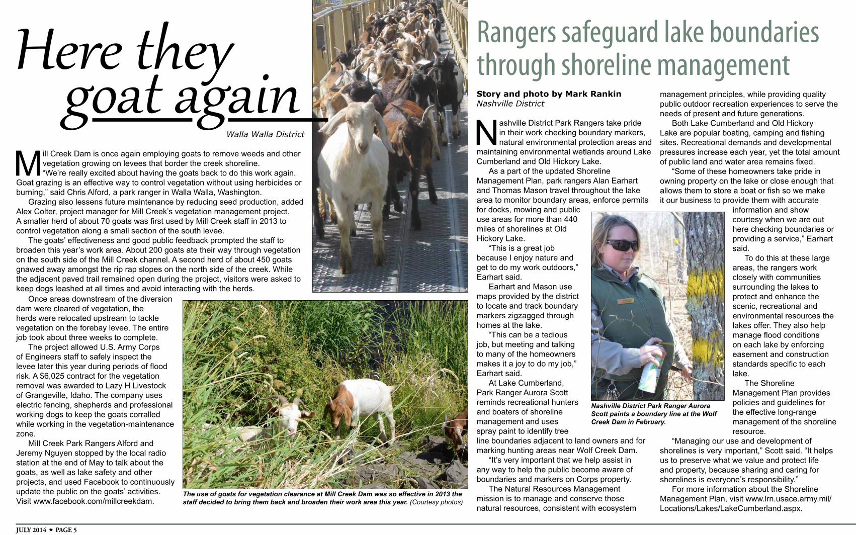
Here theyWalla Walla District
Mill Creek Dam is once again employing goats to remove weeds and other vegetation growing on levees that border the creek shoreline. “We’re really excited about having the goats back to do this work again.
Goat grazing is an effective way to control vegetation without using herbicides or burning,” said Chris Alford, a park ranger in Walla Walla, Washington.
Grazing also lessens future maintenance by reducing seed production, added Alex Colter, project manager for Mill Creek’s vegetation management project. A smaller herd of about 70 goats was first used by Mill Creek staff in 2013 to control vegetation along a small section of the south levee.
The goats’ effectiveness and good public feedback prompted the staff to broaden this year’s work area. About 200 goats ate their way through vegetation on the south side of the Mill Creek channel. A second herd of about 450 goats gnawed away amongst the rip rap slopes on the north side of the creek. While the adjacent paved trail remained open during the project, visitors were asked to keep dogs leashed at all times and avoid interacting with the herds.
goat again
Once areas downstream of the diversion dam were cleared of vegetation, the herds were relocated upstream to tackle vegetation on the forebay levee. The entire job took about three weeks to complete.
The project allowed U.S. Army Corps of Engineers staff to safely inspect the levee later this year during periods of flood risk. A $6,025 contract for the vegetation removal was awarded to Lazy H Livestock of Grangeville, Idaho. The company uses electric fencing, shepherds and professional working dogs to keep the goats corralled while working in the vegetation-maintenance zone.
Mill Creek Park Rangers Alford and Jeremy Nguyen stopped by the local radio station at the end of May to talk about the goats, as well as lake safety and other projects, and used Facebook to continuously update the public on the goats’ activities. Visit www.facebook.com/millcreekdam.
The use of goats for vegetation clearance at Mill Creek Dam was so effective in 2013 the staff decided to bring them back and broaden their work area this year. (Courtesy photos)
Rangers safeguard lake boundaries through shoreline managementStory and photo by Mark RankinNashville District
Nashville District Park Rangers take pride in their work checking boundary markers, natural environmental protection areas and
maintaining environmental wetlands around Lake Cumberland and Old Hickory Lake.
As a part of the updated Shoreline Management Plan, park rangers Alan Earhart and Thomas Mason travel throughout the lake area to monitor boundary areas, enforce permits for docks, mowing and public use areas for more than 440 miles of shorelines at Old Hickory Lake.
“This is a great job because I enjoy nature and get to do my work outdoors,” Earhart said.
Earhart and Mason use maps provided by the district to locate and track boundary markers zigzagged through homes at the lake.
“This can be a tedious job, but meeting and talking to many of the homeowners makes it a joy to do my job,” Earhart said.
At Lake Cumberland, Park Ranger Aurora Scott reminds recreational hunters and boaters of shoreline management and uses spray paint to identify tree line boundaries adjacent to land owners and for marking hunting areas near Wolf Creek Dam.
“It’s very important that we help assist in any way to help the public become aware of boundaries and markers on Corps property.
The Natural Resources Management mission is to manage and conserve those natural resources, consistent with ecosystem
management principles, while providing quality public outdoor recreation experiences to serve the needs of present and future generations.
Both Lake Cumberland and Old Hickory Lake are popular boating, camping and fishing sites. Recreational demands and developmental pressures increase each year, yet the total amount of public land and water area remains fixed.
“Some of these homeowners take pride in owning property on the lake or close enough that allows them to store a boat or fish so we make it our business to provide them with accurate
information and show courtesy when we are out here checking boundaries or providing a service,” Earhart said.
To do this at these large areas, the rangers work closely with communities surrounding the lakes to protect and enhance the scenic, recreational and environmental resources the lakes offer. They also help manage flood conditions on each lake by enforcing easement and construction standards specific to each lake.
The Shoreline Management Plan provides policies and guidelines for the effective long-range management of the shoreline resource.
“Managing our use and development of shorelines is very important,” Scott said. “It helps us to preserve what we value and protect life and property, because sharing and caring for shorelines is everyone’s responsibility.”
For more information about the Shoreline Management Plan, visit www.lrn.usace.army.mil/Locations/Lakes/LakeCumberland.aspx.
Nashville District Park Ranger Aurora Scott paints a boundary line at the Wolf Creek Dam in February.
THE CORPS ENVIRONMENT PAGE 6
Education & prEvEntion first line of defense in invasive species management
The Invasion Curve illustrates that prevention is the most efficient and least costly method of combating invasive species. As a non-native species becomes more established over time, the effort and associated costs of addressing it escalate exponentially. (From the USDA Forest Service 2005 Invasive Plant Environmental Impact Statement)
By Tim ToplisekU.S. Army Corps of EngineersSenior Policy Adviser for Invasive Species Management
For the past decade, the U.S. Army Corps of Engineers and state departments of natural resources — especially those near the Great Lakes — have focused their efforts on controlling the migration of
Asian Carp, a known invasive species, before it reaches the Great Lakes. It’s been a challenge.
The Army Corps of Engineers spends about $145 million a year to control and restore damage caused by invasive species, a figure that is escalating with the spread of existing species and the introduction of new invasive species. Effective invasive species education and prevention programs can help mitigate the spread of new invasive species like the snakehead, an air-breathing freshwater fish not native to North America.
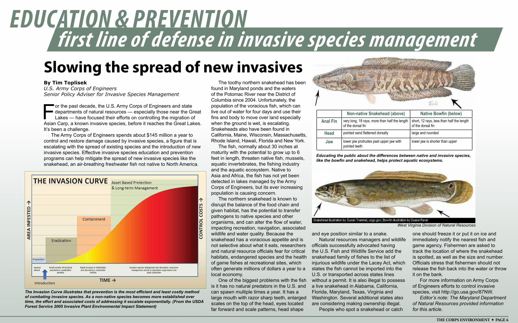
Slowing the spread of new invasivesThe toothy northern snakehead has been
found in Maryland ponds and the waters of the Potomac River near the District of Columbia since 2004. Unfortunately, the population of the voracious fish, which can live out of water for four days and use their fins and body to move over land especially when the ground is wet, is escalating. Snakeheads also have been found in California, Maine, Wisconsin, Massachusetts, Rhode Island, Hawaii, Florida and New York.
The fish, normally about 30 inches at maturity with the potential to grow up to 6 feet in length, threaten native fish, mussels, aquatic invertebrates, the fishing industry and the aquatic ecosystem. Native to Asia and Africa, the fish has not yet been detected in lakes managed by the Army Corps of Engineers, but its ever increasing population is causing concern.
The northern snakehead is known to disrupt the balance of the food chain and given habitat, has the potential to transfer pathogens to native species and other organisms, and can alter the flow of water, impacting recreation, navigation, associated wildlife and water quality. Because the snakehead has a voracious appetite and is not selective about what it eats, researchers and natural resource officials fear for critical habitats, endangered species and the health of game fishes at recreational sites, which often generate millions of dollars a year to a local economy.
One of the biggest problems with the fish is it has no natural predators in the U.S. and can spawn multiple times a year. It has a large mouth with razor sharp teeth, enlarged scales on the top of the head, eyes located far forward and scale patterns, head shape
and eye position similar to a snake.Natural resources managers and wildlife
officials successfully advocated having the U.S. Fish and Wildlife Service add the snakehead family of fishes to the list of injurious wildlife under the Lacey Act, which states the fish cannot be imported into the U.S. or transported across states lines without a permit. It is also illegal to possess a live snakehead in Alabama, California, Florida, Maryland, Texas, Virginia and Washington. Several additional states also are considering making ownership illegal.
People who spot a snakehead or catch
West Virginia Division of Natural Resources
one should freeze it or put it on ice and immediately notify the nearest fish and game agency. Fishermen are asked to track the location of where the snakehead is spotted, as well as the size and number. Officials stress that fishermen should not release the fish back into the water or throw it on the bank.
For more information on Army Corps of Engineers efforts to control invasive species, visit http://go.usa.gov/87NW.
Editor’s note: The Maryland Department of Natural Resources provided information for this article.
Non-native Snakehead (above) Native Bowfin (below)Anal Fin very long, 18 rays, more than half the length
of the dorsal finshort, 12 rays, less than half the length of the dorsal fin
Head pointed sand flattened dorsally large and rounded
Jaw lower jaw protrudes past upper jaw with pointed teeth
lower jaw is shorter than upper
Educating the public about the differences between native and invasive species, like the bowfin and snakehead, helps protect aquatic ecosystems.
JULY 2014 PAGE 7
By Erica SkolteJacksonville District
Across Florida and throughout the nation, invasive species bring with them high ecological and economic costs. It’s far too big a problem for just one agency or group. The Florida Invasive Species Partnership
(FISP) is a collaborative group of federal, state and local agencies and non-government organizations, all with a stake in managing non-native species in Florida. FISP facilitates the formation of Cooperative Invasive Species Management Areas (CISMAs), alliances of stakeholders addressing regional invasive species management. Some of the concerns they try to address include prevention, education/awareness, early detection, rapid response, monitoring and integrated pest management.
“It’s really important to be able to get on top of these species early on,” said Jessica Spencer, a Jacksonville District biologist and member of the First Coast Invasive Working Group, the CISMA that covers northeast Florida. “We’ve got to control the problem before the species becomes established and starts to expand its range. Once the population expands, the impacts and the cost of control escalate exponentially.”
The cooperative groups provide expertise with common problems statewide and serve as experts on challenges in the local area. Each CISMA covers a certain type of habitat and climate zone. They are large enough to have regional impact, but small enough to deal with specific local issues.
“We try to reach out to folks on public and private lands. We provide treatment recommendations, management advice and sometimes we can even help with treatment,” Spencer said. “We are a good resource for land managers all over the state.”
Though some of the problems may overlap, others are localized. Members of these groups are often in the field and can help locally monitor species. They try to identify and deal with potential problems before they become more serious. Some of the problems in south Florida are very different from those in north Florida.
In south Florida, for example, a species of Asian mangrove (Lumnitzera racemosa) was brought into the country as a specimen plant at a botanical garden. Its population started to expand and escape into natural areas. The Everglades CISMA had multiple workdays and successfully eradicated the infestation. Follow-up is still needed to catch any new seedlings, but it appears the invasion has been stopped.
Another way CISMAs raise awareness and help control invasive animal species is to sponsor Pet Amnesty Days, where people can turn in their unwanted pets without penalties, instead of releasing them into the wild.
In Jacksonville and north Florida, some of the early detection and rapid response efforts have targeted salt cedar and old world climbing fern. Brazilian pepper has firmly established itself in south Florida and is now creeping north along the coast and seems to be headed toward Jacksonville.
For more information, visit the Florida Invasive Species Partnership website: www.floridainvasives.org and the National Invasive Species Council website: www.invasivespecies.gov/global/EDRR/EDRR_index.html.
Florida agencies work together
By Erica SkolteJacksonville District
It’s almost like a scene from a science fiction movie. Florida is being taken over by potatoes. Yes, potatoes. So, what do you do
when foreign potatoes invade and attempt to take over the native plants? You try to “nip it in the spud!”
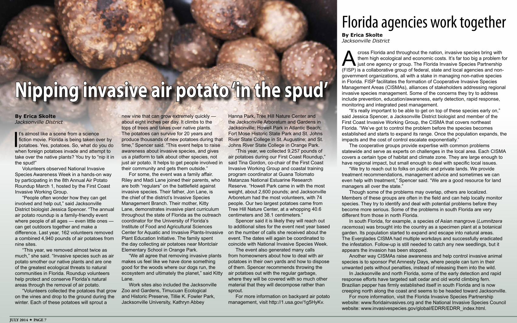
Volunteers observed National Invasive Species Awareness Week in a hands-on way by participating in the 8th Annual Air Potato Roundup March 1, hosted by the First Coast Invasive Working Group.
“People often wonder how they can get involved and help out,” said Jacksonville District biologist Jessica Spencer. “The annual air potato roundup is a family-friendly event where people of all ages — even little ones —can get outdoors together and make a difference. Last year, 162 volunteers removed a combined 4,940 pounds of air potatoes from nine sites.
“This year, we removed almost twice as much,” she said. “Invasive species such as air potato smother our native plants and are one of the greatest ecological threats to natural communities in Florida. Roundup volunteers help protect and conserve Florida’s natural areas through the removal of air potato.
“Volunteers collected the potatoes that grow on the vines and drop to the ground during the winter. Each of these potatoes will sprout a
new vine that can grow extremely quickly —about eight inches per day. It climbs to the tops of trees and takes over native plants. The potatoes can survive for 20 years and produce thousands of new potatoes during that time,” Spencer said. “This event helps to raise awareness about invasive species, and gives us a platform to talk about other species, not just air potato. It helps to get people involved in their community and gets them outside.”
For some, the event was a family affair. Riley and Madi Lane joined their parents, who are both “regulars” on the battlefield against invasive species. Their father, Jon Lane, is the chief of the district’s Invasive Species Management Branch. Their mother, Kitty Lane, demonstrates invasive plant curriculum throughout the state of Florida as the outreach coordinator for the University of Florida’s Institute of Food and Agricultural Sciences Center for Aquatic and Invasive Plants-Invasive Plant Education Initiative. The family spent the day collecting air potatoes near Montclair Elementary School in Orange Park.
“We all agree that removing invasive plants makes us feel like we have done something good for the woods where our dogs run, the ecosystem and ultimately the planet,” said Kitty Lane.
Work sites also included the Jacksonville Zoo and Gardens, Timucuan Ecological and Historic Preserve, Tillie K. Fowler Park, Jacksonville University, Kathryn Abbey
Hanna Park, Tree Hill Nature Center and the Jacksonville Arboretum and Gardens in Jacksonville; Howell Park in Atlantic Beach; Fort Mose Historic State Park and St. Johns River State College in St. Augustine; and St. Johns River State College in Orange Park.
“This year, we collected 9,257 pounds of air potatoes during our First Coast Roundup,” said Tina Gordon, co-chair of the First Coast Invasive Working Group and coastal training program coordinator at Guana Tolomato Matanzas National Estuarine Research Reserve. “Howell Park came in with the most weight, about 2,600 pounds; and Jacksonville Arboretum had the most volunteers, with 74 people. Our two largest potatoes came from Tree Hill Nature Center, at a whopping 40.6 centimeters and 38.1 centimeters.”
Spencer said it is likely they will reach out to additional sites for the event next year based on the number of calls she received about the event. The dates will again be coordinated to coincide with National Invasive Species Week.
The event also generated many calls from homeowners about how to deal with air potatoes in their own yards and how to dispose of them. Spencer recommends throwing the air potatoes out with the regular garbage, where they will be covered with so much other material that they will decompose rather than sprout.
For more information on backyard air potato management, visit http://1.usa.gov/1g5HyKv.
Nipping invasive air potato ‘in the spud’
THE CORPS ENVIRONMENT PAGE 8
By Andrew Kornacki, Lynn Greer and Rich RubyBuffalo District
Buffalo District, in cooperation with the U.S. Army Engineer Research and Development Center (ERDC),
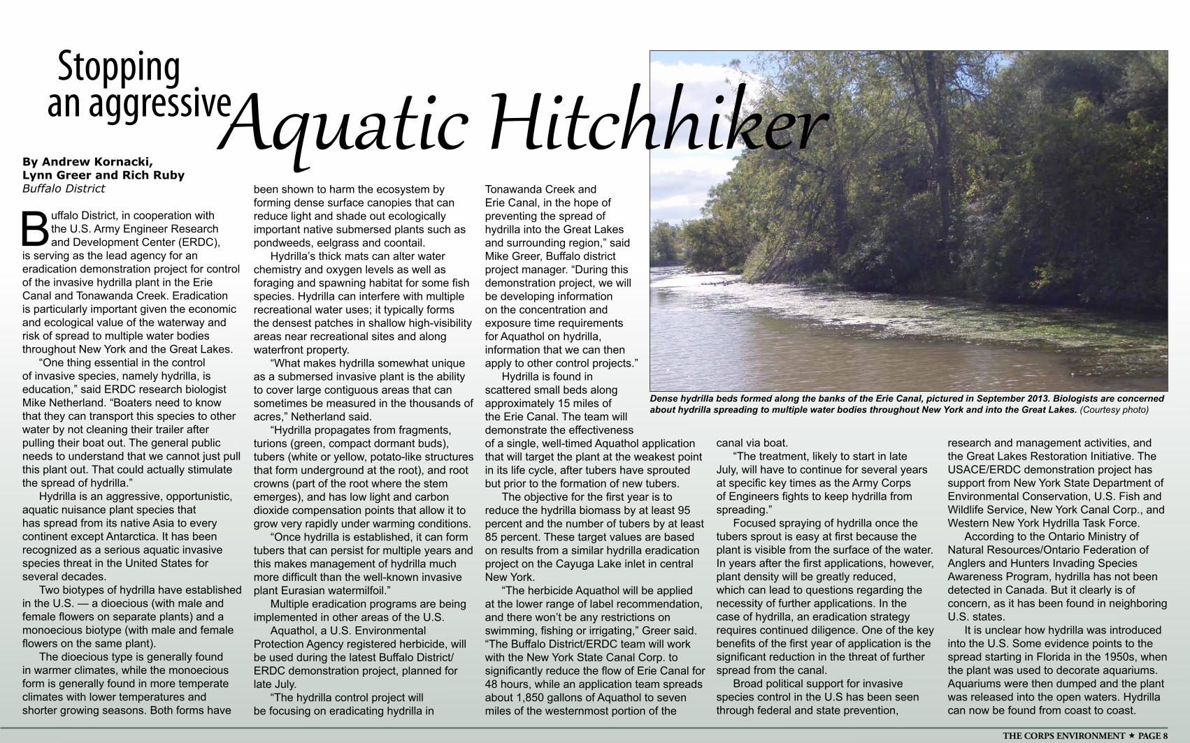
is serving as the lead agency for an eradication demonstration project for control of the invasive hydrilla plant in the Erie Canal and Tonawanda Creek. Eradication is particularly important given the economic and ecological value of the waterway and risk of spread to multiple water bodies throughout New York and the Great Lakes.
“One thing essential in the control of invasive species, namely hydrilla, is education,” said ERDC research biologist Mike Netherland. “Boaters need to know that they can transport this species to other water by not cleaning their trailer after pulling their boat out. The general public needs to understand that we cannot just pull this plant out. That could actually stimulate the spread of hydrilla.”
Hydrilla is an aggressive, opportunistic, aquatic nuisance plant species that has spread from its native Asia to every continent except Antarctica. It has been recognized as a serious aquatic invasive species threat in the United States for several decades.
Two biotypes of hydrilla have established in the U.S. — a dioecious (with male and female flowers on separate plants) and a monoecious biotype (with male and female flowers on the same plant).
The dioecious type is generally found in warmer climates, while the monoecious form is generally found in more temperate climates with lower temperatures and shorter growing seasons. Both forms have
been shown to harm the ecosystem by forming dense surface canopies that can reduce light and shade out ecologically important native submersed plants such as pondweeds, eelgrass and coontail.
Hydrilla’s thick mats can alter water chemistry and oxygen levels as well as foraging and spawning habitat for some fish species. Hydrilla can interfere with multiple recreational water uses; it typically forms the densest patches in shallow high-visibility areas near recreational sites and along waterfront property.
“What makes hydrilla somewhat unique as a submersed invasive plant is the ability to cover large contiguous areas that can sometimes be measured in the thousands of acres,” Netherland said.
“Hydrilla propagates from fragments, turions (green, compact dormant buds), tubers (white or yellow, potato-like structures that form underground at the root), and root crowns (part of the root where the stem emerges), and has low light and carbon dioxide compensation points that allow it to grow very rapidly under warming conditions.
“Once hydrilla is established, it can form tubers that can persist for multiple years and this makes management of hydrilla much more difficult than the well-known invasive plant Eurasian watermilfoil.”
Multiple eradication programs are being implemented in other areas of the U.S.
Aquathol, a U.S. Environmental Protection Agency registered herbicide, will be used during the latest Buffalo District/ERDC demonstration project, planned for late July.
“The hydrilla control project will be focusing on eradicating hydrilla in
Tonawanda Creek and Erie Canal, in the hope of preventing the spread of hydrilla into the Great Lakes and surrounding region,” said Mike Greer, Buffalo district project manager. “During this demonstration project, we will be developing information on the concentration and exposure time requirements for Aquathol on hydrilla, information that we can then apply to other control projects.”
Hydrilla is found in scattered small beds along approximately 15 miles of the Erie Canal. The team will demonstrate the effectiveness of a single, well-timed Aquathol application that will target the plant at the weakest point in its life cycle, after tubers have sprouted but prior to the formation of new tubers.
The objective for the first year is to reduce the hydrilla biomass by at least 95 percent and the number of tubers by at least 85 percent. These target values are based on results from a similar hydrilla eradication project on the Cayuga Lake inlet in central New York.
“The herbicide Aquathol will be applied at the lower range of label recommendation, and there won’t be any restrictions on swimming, fishing or irrigating,” Greer said. “The Buffalo District/ERDC team will work with the New York State Canal Corp. to significantly reduce the flow of Erie Canal for 48 hours, while an application team spreads about 1,850 gallons of Aquathol to seven miles of the westernmost portion of the
canal via boat. “The treatment, likely to start in late
July, will have to continue for several years at specific key times as the Army Corps of Engineers fights to keep hydrilla from spreading.”
Focused spraying of hydrilla once the tubers sprout is easy at first because the plant is visible from the surface of the water. In years after the first applications, however, plant density will be greatly reduced, which can lead to questions regarding the necessity of further applications. In the case of hydrilla, an eradication strategy requires continued diligence. One of the key benefits of the first year of application is the significant reduction in the threat of further spread from the canal.
Broad political support for invasive species control in the U.S has been seen through federal and state prevention,
research and management activities, and the Great Lakes Restoration Initiative. The USACE/ERDC demonstration project has support from New York State Department of Environmental Conservation, U.S. Fish and Wildlife Service, New York Canal Corp., and Western New York Hydrilla Task Force.
According to the Ontario Ministry of Natural Resources/Ontario Federation of Anglers and Hunters Invading Species Awareness Program, hydrilla has not been detected in Canada. But it clearly is of concern, as it has been found in neighboring U.S. states.
It is unclear how hydrilla was introduced into the U.S. Some evidence points to the spread starting in Florida in the 1950s, when the plant was used to decorate aquariums. Aquariums were then dumped and the plant was released into the open waters. Hydrilla can now be found from coast to coast.
Dense hydrilla beds formed along the banks of the Erie Canal, pictured in September 2013. Biologists are concerned about hydrilla spreading to multiple water bodies throughout New York and into the Great Lakes. (Courtesy photo)
Stopping
Aquatic Hitchhikeran aggressive
JULY 2014 PAGE 9
SustainabilityContinued from Page 1
By Candice WaltersU.S. Army Corps of Engineers Headquarters Public Affairs
Anew “old” cadre is being stood up across the U.S. Army Corps of Engineers to provide commanders environmental subject matter experts both abroad and at home.
For years, Environmental Support Teams (EnvST) have deployed to conduct a number of environmental surveys that would include Environmental Baseline Surveys (EBSs), Environmental Condition Surveys (ECS) and Environmental Site Closure Surveys (ESCS) for deploying U.S. forces. However, in the past few years, it has become apparent the environmental support requirements of a warfighter involve much more than just conducting the environmental surveys.
“Instead, the Corps of Engineers began finding that the on-the-ground needs required environmental subject matter experts who could cover a wide range of environmental issues to include water supply and sanitation, and solid and hazardous waste management. That led to the need to reach beyond the existing EnvST to find additional subject matter experts,” said Douglas Warnock, Headquarters EnvST program manager.
Historically the USACE divisions were responsible for maintaining eight EnvST teams, which consisted of 32 people and operated on an 18-month cycle of availability, team training and reset. Under the “old” EnvST concept, four to five environmental professionals would deploy to a contingency operations location as a team.
However, it just never seemed to happen that way, said Suresh Kikkeri, a Water Resources Program manager, a lead environmental engineer at Transatlantic Division (TAD), and an EnvST member for the past 12 years.
“Having been involved with overseas contingency operations in CENTCOM (Central Command), my experience is that typically, there won’t be a need for a team of environmental professionals for the mission, one or two people would suffice. Typically, the division would identify an EnvST environmental professional and that one person would deploy as part of a Forward Engineer Support Team (FEST).”
As part of Fragmentary Order 6 of Operation Order 2012-68, published May 12, the old EnvST concept was replaced with a new cadre of environmental subject matter experts from throughout USACE who will deploy as necessary to support the warfighter. The new cadre will be centralized at Headquarters within the Military Missions Environmental Division, reducing both costs and the number of trained personnel. Instead of eight teams, one resource “pool” of subject matter experts will be established with a broader mission that goes beyond just conducting environmental surveys.
The new cadre will consist of 16 deployable members focused on four major environmental disciplines: water management (drinking water, wastewater), solid waste management (hazardous, solid and medical waste, burn pits, incinerators), environmental surveys (EBS, ECS and ESCS), and special waste management (such as uranium tailings, depleted uranium waste).
“With this pool, we will have all areas represented, so depending on the situation, we will be able to pick one or two individuals with the needed expertise
and deploy them to the place where they are needed,” said Kikkeri, who has deployed to Afghanistan twice with FEST.
“While most often the cadre will be deployed to support warfighters outside the United States with a main mission of going down range before the forward operating base camps are set it, the cadre will also be available to provide support in natural disasters here in the U.S. if needed,” Warnock said.
The main focus, however, remains on supporting the warfighter, especially when establishing forward operating bases, Kikkeri said. “In Afghanistan, water became a big issue. We would have to bring in a geologist or hydrogeologist to find areas where we could drill for water, then decide if it was potable for the Soldiers to drink and then have to treat it. Next came the issue of managing the stream of waste water, solid, hazardous and medical waste, incineration, etc.,” he said.
Matthew Parks, a senior strategic planner for the Headquarters Strategic Integration Office, returned March 1 from six months in Jordan as a member of the NAU FEST-A Team (Europe District North Atlantic Division). A hydrogeologist, Parks said he has seen the EnvST concept, structure and mission change as the need and breadth of the subject matter expertise required has changed and grown.
“It has grown, but I think the cadre of skills sets remains unknown to a lot of senior leaders and Army commanders,” said Parks, who has been a member of the team since 2003. “Other service assets don’t always understand the value of an SME (subject matter expert) who understands water supply, quality, proper waste disposal and safety when it comes to water and waste. But once we get on the ground, the commanders latch onto us to solve the tough problems that they don’t have time or staff to think about.”
Parks said he believes commanders have found that addressing environmental concerns early, proactively and up front is a wiser approach versus the heavy cost of dealing with the environmental cleanup costs after the fact. Because of the lessons learned during the last four years, they are realizing the value in having USACE FEST-A teams with an EnvST SME as an integrated part of their planning team embedded and on the ground during the earliest planning stages of a mission, he said.
Another advantage of EnvST is that it gives people who have an interest in the environment an opportunity to build upon that interest. “You don’t have to work in the environmental field to be part of the team,” Parks said. “For example, when I deployed, the Environmental Team lead was an employee who worked in Resource Management but had a degree in biology. You just have to have the subject knowledge, that’s a requirement, but if an employee has a interest and or a passion for the subject then they will succeed.
“There are a great many multi-talented people within USACE with many capabilities that they may not practice daily. Being part of the EnvST gives them an opportunity to take advantage of those skills and is an example of USACE’s value added to the warfighter.”
Environmental SMEs from throughout USACE have been identified to be EnvST cadre members who will be supported by military planners from each division.
ESPCs, or Energy Savings Performance Contracts, are tools available to help us reach the higher-hanging fruit, and do so more quickly and effectively than we ever would with appropriated funds.
“We have to change the culture within the Army Corps of Engineers,” Semonite said. “There’s no free lunch anymore. We have to go to that next level of return on investment. It’s harder, and it’s very easy for people to try to talk us out of making those investments or taking those next steps to address the increasingly expensive and hard-to-do changes we need to make.
“We have to make the long-term investments and look for the long-term solutions,” he added. “We need to keep setting the example of what right looks like.”
As Deputy Chief of Engineers, Semonite says part of his job is to work sustainability issues and “to make sure we are taking small bites day to day. We have made progress with vehicle utilization (reducing the size of the agency’s vehicle fleet) and we’re doing space utilization very well. I personally track sustainability metrics throughout the agency every month, and we are making progress.
“Sustainability is one of those really important things we need to work on, and it’s one of those things where we need to take little steps at a time. Otherwise it’s going to be insurmountable if we try to tackle all our programs at once.”
Semonite says another part of his job is ensuring all Army Corps of Engineers employees know they have roles to play in ensuring the agency becomes more sustainable. It’s important for everyone to be engaged, he said.
“Everyone has to be all-in when it comes to sustainability, from ‘lighting’ usage to driving to and from work to determining the optimum square footage of a building. A little bit in the aggregate can do a lot.
“It requires us to become less averse to risk, from both a technical and cultural perspective. We have to accelerate the pace of innovation, look at different alternatives. We have to have both better and more directed conversation about sustainability and different alternatives. Are we ready to accept technical changes and take on more risk?
“We should be a leader in sustainability. It’s the right thing for business and for our environment. We can’t afford not to do it.”
Editor’s note: USACE submitted its 2014-15 Strategic Sustainability Plan to the Obama Administration at the end of June detailing how it plans to meet its sustainability goals and metrics.
USACE reinvigorates Environmental Support Teams

THE CORPS ENVIRONMENT PAGE 10
Huntington District
There is a bank under construction near Camp Creek State Forest in Spanishburg, West Virginia. While you cannot apply for a business or home
loan at this bank, the transactions projected to occur here are no less significant. Mitigation banks, like the one being developed in Spanishburg, are springing up throughout Appalachia to compensate for unwanted impacts to rivers, streams, wetlands and other aquatic resources.
Activities such as mining, hydraulic fracturing, processing chemicals and even just building homes can impair local rivers, streams and wetlands, explained Mark Taylor, a Huntington District supervisory biologist.
“We understand development will happen, but we want to make sure aquatic resources are protected,” Taylor said.
Before anyone may legally proceed with such activities, a permit from the U.S. Army Corps of Engineers is often required to satisfy certain conditions of the Clean Water Act and the Rivers and Harbors Act of 1899. Both regulations seek to protect various types of water resources against damage. Through its Regulatory Program, the Corps works hard to make sure undesired impacts to aquatic resources are avoided or minimized, Taylor said.
In some cases, however, activities will unavoidably impair rivers, streams, wetlands and other bodies of water. Federal regulations require those causing the unwanted impacts to restore, establish, enhance or preserve aquatic resources to offset losses. Such efforts, known as compensatory mitigation, help make possible natural resources exploration, extraction and processing, as well as other development activities, while protecting aquatic resources and their functions, Taylor said.
Say a permitted developer wants to build homes, but construction will cause unwanted impacts to nearby wetlands. The developer is required to alleviate the damage caused by construction operations so there will be no net loss of wetlands. The homebuilder can take the appropriate steps to mitigate damage caused to wetlands or pick from a menu of compensatory mitigation strategies, including purchasing mitigation bank “credits.”
A mitigation bank is a parcel of land or body of water on which mitigation activities, such as environmental restoration, have been conducted in anticipation of
future impacts from unrelated projects. Mitigation banking is a form of trade wherein aquatic resources are rehabilitated or restored to create credits fit for sale in the form of acres and functions. These credits can then be purchased by those causing unavoidable impacts, like the aforementioned developer. Instead of designing, constructing and monitoring the ecological success and long-term protection of a mitigation site, the developer could purchase credits from a mitigation bank developed and maintained by those with the environmental and business expertise to do it well.
In 2008, the Army Corps of Engineers and Environmental Protection Agency jointly published the “Final Rule for Compensatory Mitigation for Losses of Aquatic Resources,” which lays the groundwork for better consistency in the establishment, use and operation of all forms of compensatory mitigation, including banks. The rule requires mitigation bank proposals be reviewed, evaluated and negotiated by a team of regulatory agencies led by USACE. Called the Interagency Review Team (IRT), it works with those seeking to establish mitigation banks to develop
an instrument that explains the terms and conditions for bank approval or certification and seeks to ensure compensatory mitigation will indeed be achieved.
“It’s about leveraging collaboration, environmental science and business expertise to achieve compensatory mitigation in the most efficient and effective manner possible, said District Commander Col. Leon Parrott. “When we work cooperatively with all the relevant agencies, with the mitigation bank developers, the permittees and surrounding communities, we reduce uncertainty over whether or not compensatory mitigation will be successful in offsetting impacts.”
In West Virginia, standing members of the IRT include USACE, EPA, U.S. Fish and Wildlife Service, U.S. Department of Agriculture’s Natural Resource Conservation Service, West Virginia Department of Environmental Protection and the West Virginia Division of Natural Resources. Once a mitigation bank has been created, the IRT determines the types and number of credits that will be available for sale. Credits are purchased and subtracted from each bank until all the credits have been sold. The bank then closes to further
purchases of credits, but the mitigation banker, or landowner, is still responsible for monitoring ecological success and long-term protection of the bank for the duration of the conservation easement.
Jim Spence, a regulatory project manager with the Huntington District who is an IRT member, visits proposed mitigation bank sites and works with mitigation bankers and their consultants, which includes private-sector firms as well as government agencies and non-profits, to recommend measures and practices that will most likely result in the highest functional lift or gain.
Mitigation is only satisfied when the functional lift of credits is greater than or equal to the functional loss of the aquatic resource for which the credits are purchased to offset, Spence said. He added that compensatory mitigation is the third step in a series of activities to protect water resources.
“We first try to avoid impacts all together which could be accomplished by recommending changes to a design or modifying an activity. If impacts cannot be avoided, we try to minimize them. Finally, if there truly are unavoidable impacts, we may not grant a permit at all or we may grant a permit but will require compensatory mitigation,” Spence said. “We are not for or against development, we simply want to make sure what is lost is replaced.”
The nearly 400-acre Spanishburg mitigation bank is being developed by David Gibbons, a founder and manager of Acadia Capital Group, which has also invested in the development of a second 500-acre West Virginia site at Hayes Run.
“We create mitigation banks from damaged streams. Improving the streams and committing the banks to a permanent conservation easement ensures that streams, which are a significant asset of West Virginia, remain pristine,” Gibbons said. “Mitigation banking not only serves the business community, but also provides a benefit to the state, residents and the environment. The work we are doing today will benefit West Virginia for the next hundred years, if not longer.”
Gibbons hired Alliance Consulting Inc., headquartered in Beckley, West Virginia, to design, construct, monitor and maintain the banks at Hayes Run and Spanishburg. Shamrock Environmental Corporation, based in North Carolina, is also participating in construction at the Spanishburg site.
For more about compensatory mitigation strategies, visit http://www.usace.army.mil/Missions/CivilWorks/RegulatoryProgramandPermits/mitig_info.aspx.
Mitigation banking a win for environment, residents, investors
This stream is undergoing restoration at a mitigation bank site in Spanishburg, West Virginia. Mitigation banks, and other compensatory mitigation strategies, help make natural resources exploration, extraction, processing and other development activities possible, while protecting aquatic resources and their functions. (Courtesy photo)
JULY 2014 PAGE 11
USACE, Massachusetts Department of Fish and Gamesign agreement to protect aquatic resources
By Tim DuganNew England District
New England District and the Massachusetts Department of Fish and Game (DFG) signed an In-Lieu Fee agreement May 23 providing
an alternative form of compensatory mitigation to those seeking permits who are required to compensate for their project’s impacts to aquatic resources, wetlands and waters of the U.S. in the state of Massachusetts.
“The program purposefully advances the protection of aquatic resources in Massachusetts. It provides individuals and firms seeking a Corps permit an alternative form of compensatory mitigation,” said Col. Charles Samaris, New England District commander. “Protecting the environment is one of our core missions and part of the Chief of Engineers’ campaign plan. This In-Lieu Fee agreement contributes to accomplishing that mission.”
“We are pleased that the U.S. Army Corps of Engineers has approved DFG to sponsor this state-wide program that will result in protection and restoration of critical habitats, as well as the flexibility for developers in obtaining permits from the Corps,” said Energy and Environmental Affairs Secretary Rick Sullivan, Commonwealth of Massachusetts.
The concept of an In-lieu Fee Program (ILFP) is to allow Corps permittees, in compensation for their project’s unavoidable impacts to waters of the U.S., including wetlands, to make a monetary payment in-lieu of or in addition to doing the required mitigation themselves. The eligible projects are activities authorized under Section 404 of the Clean Water Act and/or Section 10 of the Rivers and Harbors Act. These in-lieu fee payments are made to the ILFP and administered by DFG. As the ILFP sponsor, DFG, in turn, assumes legal responsibility for implementing the required mitigation, which it will accomplish by aggregating and expending the in-lieu funds received from Army Corps of Engineers
permittees for mitigation projects. By aggregating the fees from multiple permitted
impacts, the ILFP can use the fees to develop larger compensatory projects that offer greater ecological benefits than smaller permittee-conducted mitigation. This ability to aggregate ILFP funds will facilitate mitigation projects that better contribute to watershed level conservation goals. Maine, New Hampshire, Vermont, Connecticut and New York already have Army Corps of Engineers-approved ILFPs.
“This program will improve our efforts to protect and restore natural habitats throughout the Commonwealth, including coastal waters,” said Department of Fish and Game Commissioner Mary Griffin. “We have well-established programs in land acquisition and aquatic habitat restoration that will use funds collected through the In-Lieu Fee Program to protect and enhance ecologically important aquatic resources and wildlife habitat.”
Prior to this agreement, from June 2008 to June 2013, DFG’s Division of Marine Fisheries served as the program sponsor for an ILFP established to provide mitigation for impacts to marine resources and Essential Fish Habitat in Massachusetts. Mitigation was limited to projects that altered less than one acre of aquatic resource and met the criteria for coverage under the Corps’ General Permit in Massachusetts.
The Department of Fish and Game’s three divisions — the Division of Marine Fisheries, the Division of Fisheries and Wildlife, and the Division of Ecological Restoration — will implement mitigation projects that permanently protect or restore aquatic resources and upland buffers. Examples of projects include acquisition of threatened fisheries and wildlife habitats; dam removals that improve passage for fish such as river herring, shad and eels; phragmites control in wetland habitats; and eel grass restoration in coastal waters.
For more information on the ILFP in New England, visit www.nae.usace.army.mil/Missions/Regulatory/Mitigation/InLieuFeePrograms.aspx.
Groundwater cleanup complete 15 years early
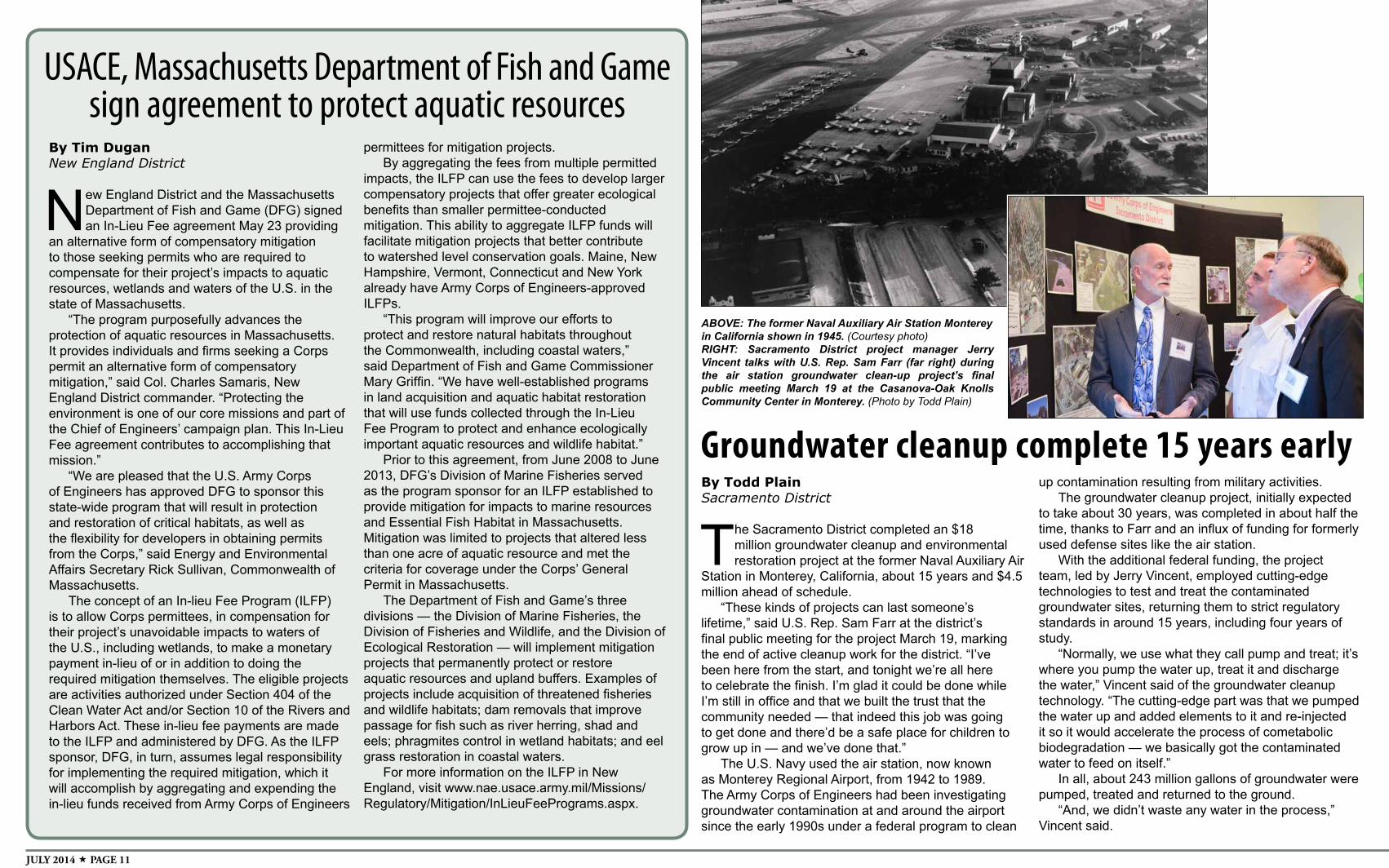
ABOVE: The former Naval Auxiliary Air Station Monterey in California shown in 1945. (Courtesy photo)RIGHT: Sacramento District project manager Jerry Vincent talks with U.S. Rep. Sam Farr (far right) during the air station groundwater clean-up project’s final public meeting March 19 at the Casanova-Oak Knolls Community Center in Monterey. (Photo by Todd Plain)
By Todd PlainSacramento District
The Sacramento District completed an $18 million groundwater cleanup and environmental restoration project at the former Naval Auxiliary Air
Station in Monterey, California, about 15 years and $4.5 million ahead of schedule.
“These kinds of projects can last someone’s lifetime,” said U.S. Rep. Sam Farr at the district’s final public meeting for the project March 19, marking the end of active cleanup work for the district. “I’ve been here from the start, and tonight we’re all here to celebrate the finish. I’m glad it could be done while I’m still in office and that we built the trust that the community needed — that indeed this job was going to get done and there’d be a safe place for children to grow up in — and we’ve done that.”
The U.S. Navy used the air station, now known as Monterey Regional Airport, from 1942 to 1989. The Army Corps of Engineers had been investigating groundwater contamination at and around the airport since the early 1990s under a federal program to clean
up contamination resulting from military activities. The groundwater cleanup project, initially expected
to take about 30 years, was completed in about half the time, thanks to Farr and an influx of funding for formerly used defense sites like the air station.
With the additional federal funding, the project team, led by Jerry Vincent, employed cutting-edge technologies to test and treat the contaminated groundwater sites, returning them to strict regulatory standards in around 15 years, including four years of study.
“Normally, we use what they call pump and treat; it’s where you pump the water up, treat it and discharge the water,” Vincent said of the groundwater cleanup technology. “The cutting-edge part was that we pumped the water up and added elements to it and re-injected it so it would accelerate the process of cometabolic biodegradation — we basically got the contaminated water to feed on itself.”
In all, about 243 million gallons of groundwater were pumped, treated and returned to the ground.
“And, we didn’t waste any water in the process,” Vincent said.
THE CORPS ENVIRONMENT PAGE 12
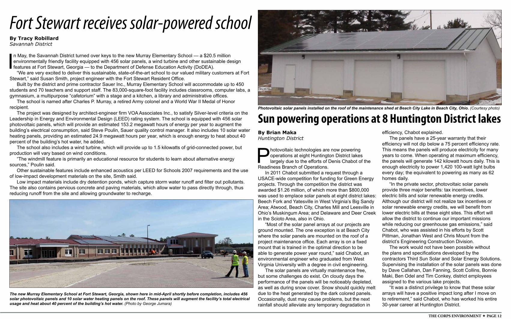
Photovoltaic solar panels installed on the roof of the maintenance shed at Beach City Lake in Beach City, Ohio. (Courtesy photo)
Sun powering operations at 8 Huntington District lakesBy Brian MakaHuntington District
Photovoltaic technologies are now powering operations at eight Huntington District lakes largely due to the efforts of Denis Chabot of the
Readiness Branch of Operations.In 2011 Chabot submitted a request through a
USACE-wide competition for funding for Green Energy projects. Through the competition the district was awarded $1.26 million, of which more than $800,000 was used to emplace solar panels at eight district lakes: Beech Fork and Yatesville in West Virginia’s Big Sandy Area; Atwood, Beach City, Charles Mill and Leesville in Ohio’s Muskingum Area; and Delaware and Deer Creek in the Scioto Area, also in Ohio.
“Most of the solar panel arrays at our projects are ground mounted. The one exception is at Beach City where the solar panels are mounted on the roof of a project maintenance office. Each array is on a fixed mount that is trained in the optimal direction to be able to generate power year round,” said Chabot, an environmental engineer who graduated from West Virginia University with a degree in civil engineering.
The solar panels are virtually maintenance free, but some challenges do exist. On cloudy days the performance of the panels will be noticeably depleted, as well as during snow cover. Snow should quickly melt due to the heat generated by the dark colored panels. Occasionally, dust may cause problems, but the next rainfall should alleviate any temporary degradation in
efficiency, Chabot explained.The panels have a 25-year warranty that their
efficiency will not dip below a 75 percent efficiency rate. This means the panels will produce electricity for many years to come. When operating at maximum efficiency, the panels will generate 142 kilowatt hours daily. This is enough electricity to power 1,420 100-watt light bulbs every day; the equivalent to powering as many as 62 homes daily.
“In the private sector, photovoltaic solar panels provide three major benefits: tax incentives, lower electric bills and solar renewable energy credits. Although our district will not realize tax incentives or solar renewable energy credits, we will benefit from lower electric bills at these eight sites. This effort will allow the district to continue our important missions while reducing our greenhouse gas emissions,” said Chabot, who was assisted in his efforts by Scott Pittman, Jonathan West and Chris Mount from the district’s Engineering Construction Division.
The work would not have been possible without the plans and specifications developed by the contractors Third Sun Solar and Solar Energy Solutions. Supervising the installation of the solar panels was done by Dave Callahan, Dan Fanning, Scott Collins, Bonnie Maki, Ben Odel and Tim Conkey, district employees assigned to the various lake projects.
“It was a distinct privilege to know that these solar arrays will have a positive impact long after I move on to retirement,” said Chabot, who has worked his entire 30-year career at Huntington District.
The new Murray Elementary School at Fort Stewart, Georgia, shown here in mid-April shortly before completion, includes 456 solar photovoltaic panels and 10 solar water heating panels on the roof. These panels will augment the facility’s total electrical usage and heat about 40 percent of the building’s hot water. (Photo by George Jumara)
By Tracy RobillardSavannah District
In May, the Savannah District turned over keys to the new Murray Elementary School — a $20.5 million environmentally friendly facility equipped with 456 solar panels, a wind turbine and other sustainable design features at Fort Stewart, Georgia — to the Department of Defense Education Activity (DoDEA).
“We are very excited to deliver this sustainable, state-of-the-art school to our valued military customers at Fort Stewart,” said Susan Smith, project engineer with the Fort Stewart Resident Office.
Built by the district and prime contractor Sauer Inc., Murray Elementary School will accommodate up to 450 students and 70 teachers and support staff. The 83,000-square-foot facility includes classrooms, computer labs, a gymnasium, a multipurpose “cafetorium” with a stage and a kitchen, a library and administrative offices.
The school is named after Charles P. Murray, a retired Army colonel and a World War II Medal of Honor recipient.
The project was designed by architect-engineer firm VOA Associates Inc., to satisfy Silver-level criteria on the Leadership in Energy and Environmental Design (LEED) rating system. The school is equipped with 456 solar photovoltaic panels, which will provide an estimated 153.2 megawatt hours of energy per year to augment the building’s electrical consumption, said Steve Poulin, Sauer quality control manager. It also includes 10 solar water heating panels, providing an estimated 24.9 megawatt hours per year, which is enough energy to heat about 40 percent of the building’s hot water, he added.
The school also includes a wind turbine, which will provide up to 1.5 kilowatts of grid-connected power, but production will vary based on wind conditions.
“The windmill feature is primarily an educational resource for students to learn about alternative energy sources,” Poulin said.
Other sustainable features include enhanced acoustics per LEED for Schools 2007 requirements and the use of low-impact development materials on the site, Smith said.
Low impact materials include dry detention ponds, which capture storm water runoff and filter out pollutants. The site also contains pervious concrete and paving materials, which allow water to pass directly through, thus reducing runoff from the site and allowing groundwater to recharge.
Fort Stewart receives solar-powered school
JULY 2014 PAGE 13
By Tracy RobillardSavannah District
Did you know that every roadway and bridge in the state of Georgia is linked to the U.S. Army Corps of
Engineers?Because of a partnership between the
Corps and the Georgia Department of Transportation (GDOT) — the lead state agency for constructing road projects —any proposed road or bridge project must first receive a permit from USACE to ensure potential impacts to wetlands are first avoided, then minimized and, lastly, compensated.
“First we always seek to avoid any impacts to wetlands or aquatic resources,” said Kelly Finch, chief of the district’s Coastal Branch. “Then we look at ways we could alter the project to minimize the environmental footprint to the most practicable extent possible. Those impacts we can’t avoid must be properly mitigated to ensure no net loss of wetlands.”
Through its regulatory program, USACE must issue permits for any construction or development that may impact streams, wetlands and aquatic resources. This authority comes from Section 404 of the Clean Water Act, which regulates the discharge of dredge or fill material in U.S. waters. USACE also must uphold the Rivers and Harbors Act, which ensures any development in rivers and waterways does not adversely impact federal navigation.
“We have a very good, collaborative, working relationship [with the Corps],” said Larry Barnes, GDOT maintenance liaison. “Both parties are willing to share information, conduct joint site visits, and exchange general guidance and experience so that we both can do what is necessary to protect the environment.”
For federally funded road projects, the USACE-GDOT partnership also extends
Partnership balances environment with developmentto the Federal Highway Administration, an agency within the U.S. Department of Transportation that supports state and local governments in the design, construction and maintenance of the nation’s highway system.
Coordination and collaborationThe Army Corps of Engineers issued
130 permits for GDOT projects this past fiscal year and 526 permits in the past five years. Barnes said that at any given time, GDOT will have six to 12 projects undergoing permitting with USACE.
GDOT’s current workload is 1,712 approved construction projects at varying stages of development, Barnes said. The agency’s total fiscal year 2014 program amount is $2.4 billion in federal, state and local projects.
That equates to a lot of permitsJoe Rivera is one of three USACE
regulators who work solely on GDOT permitting projects. His job is to ensure open communication between the two agencies to improve understanding of the permitting requirements and to ultimately streamline the process.
“We promote early coordination with GDOT to discuss all projects,” Rivera said. “This way, we can provide our comments well in advance regarding all issues relating to the permitting process, and provide them with feedback to minimize their impacts to wetlands and stream channels.”
Workshops and wetland educationOne example of agency collaboration
is biannual workshops with USACE and GDOT employees. The most recent workshop took place Feb. 19 in Macon, Georgia, with 45 people in attendance.
“These workshops educate GDOT staff members about the regulatory program, to include the application process, jurisdictional waters, types of permits and tools available to assist with
application submittals,” said Ed Johnson, chief of the Regulatory Piedmont Branch in Morrow, Georgia. “If there are changes within the regulatory program, we try to arrange a workshop to inform GDOT of those changes and how they might impact their proposed projects.”
Funding requirementsSection 214 of the Water Resources
and Development Act allows USACE to accept funds from GDOT to provide priority review of their permit applications. Essentially, it allows the Savannah District to devote three full-time regulatory specialists for GDOT permit reviews. This “allows our project managers to be proactive and build relationships with GDOT staff,” Finch said. “It allows a Corps project manager to follow a project from start to finish and to understand the unique needs of each project.”
Objective permit decisionsStan Knight is another USACE
regulator who works specifically on GDOT projects. Knight also worked closely with the Charleston District to permit construction for the Savannah Back River bridge project, which spanned two regulatory jurisdictions in Georgia and South Carolina.
“The biggest challenge is making sure GDOT understands my role as a Corps regulator and not a GDOT employee,” Knight said. “My first priority is to ensure that a fair and balanced, non-biased permit decision is made on every permit action.”
As Georgia continues to maintain, develop and improve its roadways and transportation infrastructure, the partnership between USACE and GDOT is essential — especially as the regulatory program adapts to new ways of doing business.
For more information about Savannah District’s regulatory program, visit www.sas.usace.army.mil/regulatory.
Story and photo by Clem Gaines Baltimore District
It may look like a network cable coming out of the back of a regular laptop (well, OK, it IS a network cable coming out of the back of a regular laptop) but this wire is unique — it will soon connect multiple buildings on Fort Detrick, Maryland, together in an energy
monitoring and conservation project.Using funds from the Army’s Energy Conservation Investment Program, engineers from
the Baltimore District are connecting 11 buildings in a pilot project.“Our goal is to build a central monitoring system for nine systems here and two
buildings on the Forest Glen Annex,” said Project Manager William Hettchen from the district’s Fort Detrick Integrated Program Office. “The project will give installation officials the ability to track facility energy use, look for trends and find ways for each facility to be more efficient and thereby save on energy costs. The installation will also have the data to support energy conservation actions in these buildings.”
The selected facilities are all of more modern construction.
“We need fairly recently constructed buildings that have control systems with fully integrated heating, ventilation and air conditioning systems,” said project engineer William Conroy. In older facilities, there are multiple thermostats for multiple areas and often, different temperature settings, which Conroy said is not a best business practice for efficient energy use.
This ECIP project will provide immediate and recordable energy use data from each building via a secure website to a central monitoring point at the installation’s Directorate of Public Works. The system is designed to interface with the Army’s Meter Data Management System to track energy usage down to a single building. Local technicians will be trained to access and interpret the data to make energy adjustments for efficiency and to spot trends. Over time, this monitoring and subsequent actions, as well as data accumulation, will lead to cost savings through intentional and more efficient energy use. In addition, the installation can later connect more buildings through the project’s dedicated server to increase overall energy efficiency on the installation.
A key component of the Army Corps of Engineers $754,000 contract awarded in October 2012 was to develop and field an effective software package (currently under testing) to reach the project’s goals. At more than 90 percent complete as of June 9, the project was ahead of schedule with nine out of the 11 buildings connected.
“This truly is an investment program that will lead to energy conservation in these buildings,” said Hettchen, “and elsewhere on the installation.”
Connecting garrison buildingsto improve, reduce energy use
A network cable links the energy use controls for each connected building to a central monitoring station.
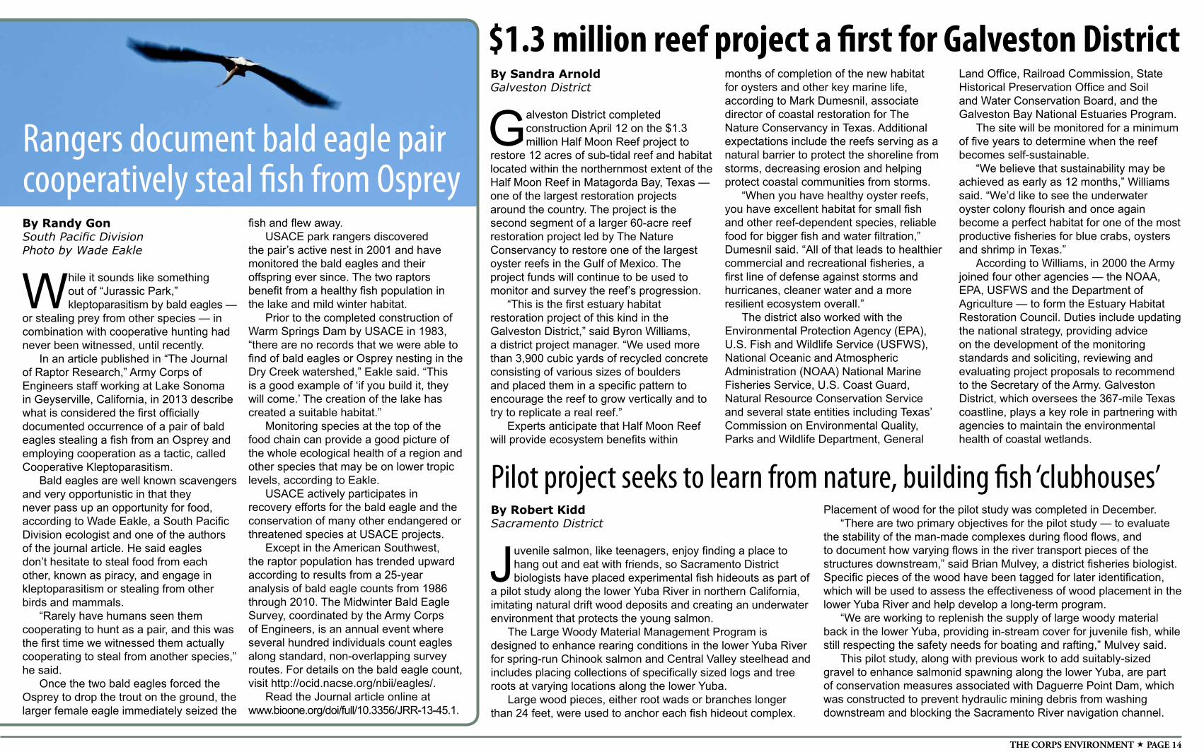
THE CORPS ENVIRONMENT PAGE 14
By Randy GonSouth Pacific DivisionPhoto by Wade Eakle
While it sounds like something out of “Jurassic Park,” kleptoparasitism by bald eagles —
or stealing prey from other species — in combination with cooperative hunting had never been witnessed, until recently.
In an article published in “The Journal of Raptor Research,” Army Corps of Engineers staff working at Lake Sonoma in Geyserville, California, in 2013 describe what is considered the first officially documented occurrence of a pair of bald eagles stealing a fish from an Osprey and employing cooperation as a tactic, called Cooperative Kleptoparasitism.
Bald eagles are well known scavengers and very opportunistic in that they never pass up an opportunity for food, according to Wade Eakle, a South Pacific Division ecologist and one of the authors of the journal article. He said eagles don’t hesitate to steal food from each other, known as piracy, and engage in kleptoparasitism or stealing from other birds and mammals.
“Rarely have humans seen them cooperating to hunt as a pair, and this was the first time we witnessed them actually cooperating to steal from another species,” he said.
Once the two bald eagles forced the Osprey to drop the trout on the ground, the larger female eagle immediately seized the
fish and flew away.USACE park rangers discovered
the pair’s active nest in 2001 and have monitored the bald eagles and their offspring ever since. The two raptors benefit from a healthy fish population in the lake and mild winter habitat.
Prior to the completed construction of Warm Springs Dam by USACE in 1983, “there are no records that we were able to find of bald eagles or Osprey nesting in the Dry Creek watershed,” Eakle said. “This is a good example of ‘if you build it, they will come.’ The creation of the lake has created a suitable habitat.”
Monitoring species at the top of the food chain can provide a good picture of the whole ecological health of a region and other species that may be on lower tropic levels, according to Eakle.
USACE actively participates in recovery efforts for the bald eagle and the conservation of many other endangered or threatened species at USACE projects.
Except in the American Southwest, the raptor population has trended upward according to results from a 25-year analysis of bald eagle counts from 1986 through 2010. The Midwinter Bald Eagle Survey, coordinated by the Army Corps of Engineers, is an annual event where several hundred individuals count eagles along standard, non-overlapping survey routes. For details on the bald eagle count, visit http://ocid.nacse.org/nbii/eagles/.
Read the Journal article online at www.bioone.org/doi/full/10.3356/JRR-13-45.1.
Rangers document bald eagle paircooperatively steal fish from Osprey
By Sandra ArnoldGalveston District
Galveston District completed construction April 12 on the $1.3 million Half Moon Reef project to
restore 12 acres of sub-tidal reef and habitat located within the northernmost extent of the Half Moon Reef in Matagorda Bay, Texas —one of the largest restoration projects around the country. The project is the second segment of a larger 60-acre reef restoration project led by The Nature Conservancy to restore one of the largest oyster reefs in the Gulf of Mexico. The project funds will continue to be used to monitor and survey the reef’s progression.
“This is the first estuary habitat restoration project of this kind in the Galveston District,” said Byron Williams, a district project manager. “We used more than 3,900 cubic yards of recycled concrete consisting of various sizes of boulders and placed them in a specific pattern to encourage the reef to grow vertically and to try to replicate a real reef.”
Experts anticipate that Half Moon Reef will provide ecosystem benefits within
$1.3 million reef project a first for Galveston Districtmonths of completion of the new habitat for oysters and other key marine life, according to Mark Dumesnil, associate director of coastal restoration for The Nature Conservancy in Texas. Additional expectations include the reefs serving as a natural barrier to protect the shoreline from storms, decreasing erosion and helping protect coastal communities from storms.
“When you have healthy oyster reefs, you have excellent habitat for small fish and other reef-dependent species, reliable food for bigger fish and water filtration,” Dumesnil said. “All of that leads to healthier commercial and recreational fisheries, a first line of defense against storms and hurricanes, cleaner water and a more resilient ecosystem overall.”
The district also worked with the Environmental Protection Agency (EPA), U.S. Fish and Wildlife Service (USFWS), National Oceanic and Atmospheric Administration (NOAA) National Marine Fisheries Service, U.S. Coast Guard, Natural Resource Conservation Service and several state entities including Texas’ Commission on Environmental Quality, Parks and Wildlife Department, General
Land Office, Railroad Commission, State Historical Preservation Office and Soil and Water Conservation Board, and the Galveston Bay National Estuaries Program.
The site will be monitored for a minimum of five years to determine when the reef becomes self-sustainable.
“We believe that sustainability may be achieved as early as 12 months,” Williams said. “We’d like to see the underwater oyster colony flourish and once again become a perfect habitat for one of the most productive fisheries for blue crabs, oysters and shrimp in Texas.”
According to Williams, in 2000 the Army joined four other agencies — the NOAA, EPA, USFWS and the Department of Agriculture — to form the Estuary Habitat Restoration Council. Duties include updating the national strategy, providing advice on the development of the monitoring standards and soliciting, reviewing and evaluating project proposals to recommend to the Secretary of the Army. Galveston District, which oversees the 367-mile Texas coastline, plays a key role in partnering with agencies to maintain the environmental health of coastal wetlands.
By Robert KiddSacramento District
Juvenile salmon, like teenagers, enjoy finding a place to hang out and eat with friends, so Sacramento District biologists have placed experimental fish hideouts as part of
a pilot study along the lower Yuba River in northern California, imitating natural drift wood deposits and creating an underwater environment that protects the young salmon.
The Large Woody Material Management Program is designed to enhance rearing conditions in the lower Yuba River for spring-run Chinook salmon and Central Valley steelhead and includes placing collections of specifically sized logs and tree roots at varying locations along the lower Yuba.
Large wood pieces, either root wads or branches longer than 24 feet, were used to anchor each fish hideout complex.
Pilot project seeks to learn from nature, building fish ‘clubhouses’Placement of wood for the pilot study was completed in December.
“There are two primary objectives for the pilot study — to evaluate the stability of the man-made complexes during flood flows, and to document how varying flows in the river transport pieces of the structures downstream,” said Brian Mulvey, a district fisheries biologist. Specific pieces of the wood have been tagged for later identification, which will be used to assess the effectiveness of wood placement in the lower Yuba River and help develop a long-term program.
“We are working to replenish the supply of large woody material back in the lower Yuba, providing in-stream cover for juvenile fish, while still respecting the safety needs for boating and rafting,” Mulvey said.
This pilot study, along with previous work to add suitably-sized gravel to enhance salmonid spawning along the lower Yuba, are part of conservation measures associated with Daguerre Point Dam, which was constructed to prevent hydraulic mining debris from washing downstream and blocking the Sacramento River navigation channel.
JULY 2014 PAGE 15
By Ariane PinsonAlbuquerque District
We’re standing knee-deep in Rio Grande mud, squinting in the bright sunlight. I close my eyes and drink in the lazy sounds and smells of the
bosque. A Great Blue Heron wings by.The cry, “I’ve got silver!” sets us all in motion.
Biologists have brought the nets ashore and wriggling within them are a dozen small fish, among which are seven endangered Rio Grande silvery minnow (Hybognathus amarus). The fish are rapidly transferred to a water-filled bucket from where they are quickly measured, weighed and released. All but one exceed 70mm in length. They are not young-of-the-year, but this is not surprising: this year’s drought meant that the spring runoff was not large enough to cue spawning.
Albuquerque District Fishery Biologist Michael “Mick” Porter is satisfied with the catch. We are out on the river collecting data for a study on silvery minnow populations in the Middle Rio Grande. Porter’s team is funded by the USACE Middle Rio Grande Endangered Species Collaborative Program to evaluate whether previous population censuses accurately counted fish. The standard method is to use a beach seine, a flat,
Seining for ‘silver’ in Rio Granderectangular net that is dragged upstream through a section of water. Using this method, the majority of silvery minnow sampled were small, young-of-the-year. Large, old adults were rarely caught. This led to the conclusion that silvery minnow are a short-lived species, with life-spans in the 1- to 3-year range.
However, collections at the University of New Mexico Museum of Southwestern Biology made earlier this century contained larger, older individuals. Had damming the river and diverting water for irrigation somehow reduced the average lifespan of individual fish? If large fish were not turning up in nets, did that mean they were not there, or did it mean they were not being caught using this method?
Porter suspected that the standard beach seining method used to census fish could be biasing the results. Larger, faster-moving fish could swim out of the way of the net while small, young, slower-swimming fish could not. So Porter designed a two-net system, consisting of the standard beach seine and a bag seine. Whereas the beach seine is a flat piece of net, the bag seine has a three dimensional shape that enables it to bulge in a downstream direction, better trapping fish. The two nets are deployed facing each other in the river at a measured distance. The beach seine is walked
downstream to the stationary bag seine, and when the two meet, the catch is brought to shore.
Once on shore, the catch in each net is tallied by species and size. So far this season in early fiscal year 2014, the number of fish caught in each net is approximately equal, suggesting that both nets do equally well at catching fish. But, intriguingly, the minnows have almost all been caught in the bag seine. Porter points out that this year was a “lean year for minnows” in the sense that low spring water levels meant that few minnows reproduced. The minnows caught to date are almost entirely large fish. Because minnows grow continuously, age is correlated with size. In historic collections, the majority of fish in the size range being caught this year are estimated at 3 years old and older. Most intriguingly, the minnows caught in the bag seine are larger, presumably older individuals.
“It would be interesting to repeat this study in a ‘good’ year to see whether different age classes occur in different nets,” Porter said. “I would expect either the young to be split evenly between the nets or to be found more frequently in the mobile beach seine. As they get older, I would expect more and more of them in the bag seine.”
If it turns out that larger minnows are able to avoid
capture when beach seines are used for sampling, and smaller minnows are not, this would have broad implications for our understanding of minnow populations on the Middle Rio Grande. Current understanding is based mainly on population censuses using beach seines, which have suggested minnows are small, short-lived and vulnerable to population failure when drought stymies reproduction. The new data suggest that minnows may be larger, longer-lived fish with populations that may be somewhat larger than previously estimated. Importantly, a longer life span would offer greater resilience to drought and other causes of reproductive failure than is currently thought. The minnow data also suggest that undercounting of older age classes may be occurring for other fish species in the Rio Grande and elsewhere. Porter’s study is therefore being watched with great interest by fisheries biologists across the U.S.
Porter is optimistic his preliminary observations will be upheld as the number of fish sampling events increases. He wants to continue the study through the end of FY 14 and possibly repeat it in an out year when a large snowpack offers the chance for good reproduction. But for now, the nets are empty and it’s time to move up river and sample at the next location.
THE CORPS ENVIRONMENT PAGE 16
By John BudnikAlaska District
Imagine walking three miles every day for potable water to complete daily chores. This is reality for many Sri Lankans — until
Alaska District engineers finish connecting hundreds of Puttalam households to the town’s water supply.
Located in western Sri Lanka, the Puttalam project was identified as a priority by the Department of State to improve the living conditions of the community. The Alaska District is on schedule to accomplish the connections in September 2014 — one year after the project’s onset. Approximately 100 homes are already tapped into the system and steady progress continues with 10 to 15 homes linked up each week.
“This is a very unique and meaningful project that demonstrates the district's ability to deliver for our customers. By evaluating all available options, we were able to execute this priority project for the U.S. Ambassador,” said Stan Wharry, chief of the Asia Office in the Environmental and Special Projects Branch.
Clean water to satisfy parched throats and more time for other activities are becoming a new standard for 371 families living below Sri Lanka’s poverty line.
The new hook-ups are drawing water from existing main supply pipes owned and operated by the Puttalam Water District alongside neighborhood roads.
The additional network is delivering water to residents’ front door steps through an outdoor spigot and water meter.
“They are thankful that someone has taken notice and wants to better their community,” said Mike MacMillan, project manager in the Environmental and Special Projects Branch overseeing
the construction.Since 2009, the district has constructed
schools, medical clinics and cyclone shelters for the U.S. Pacific Command, which is responsible for providing humanitarian assistance to 36 countries across the Asian and Pacific regions. Installing water connections for Puttalam residents puts a face to the construction.
“This project is an excellent example of U.S. Pacific Command’s humanitarian assistance program and we are excited to be part of it. We were able to team with them and local host nation partners to cost effectively provide drinking water to those in need,” Wharry said.
Residents no longer have to spend four to five hours per day collecting water. The extra time has led to more focus on other activities like fishing, salt production and
other practical improvements.“I notice that family priorities have
changed. Strengthening the community and securing work are the focus instead of obtaining clean water,” MacMillan described. “People have hope.”
MacMillan periodically visits the construction sites to ensure each connection is correctly installed by local contractors; all the hookups require approval from the Puttalam Water District. MacMillan’s duties have also included writing letters to the water district expressing the importance of the project and helping Sri Lankan contractors navigate the intricacies working with the U.S. government.
The U.S. Agency for International Development (USAID) has provided support during the construction of the project, as well. Auff Magbool, senior engineer and project management specialist for USAID, frequently visits the project sites to assist the district with quality assurance. The local Sri Lankan is instrumental in coordinating with the local government, water district, contractor and recipients of the water.
“These deserving people used to walk miles to fetch water for drinking daily. For washing and bathing, they used to go to lakes, riverbanks or [elsewhere] kilometers away every other day. During drought it was terrible,” Magbool explained. “Now they get adequate clean water at their doorsteps throughout the year. Their dream became a reality today.”
Interest in the community has grown rapidly with more than just the homeowners using the new water spigots.
“It started as a project to help about 1,200 people,” MacMillan said. “It’s now 4,000 to 5,000 since the extended families and neighbors of the connected households are helping to pay for and use the water, too.”
Water can be taken for granted when the life-sustaining element is always available at the flick of a faucet handle. Perhaps for these Sri Lankan residents, the thought of walking three miles per day for water will become a distant memory.
Mike MacMillan, project manager in the Environmental Special Projects Branch, poses with a newly installed water spigot near Puttalam, Sri Lanka. (Courtesy photo)
Delivering hope, potable water in Sri Lanka
By Marie DarlingU.S. Army Engineer Research and Development Center
The U.S. Army Engineer Research and Development Center (ERDC) Cold Regions Research and Engineering Laboratory (CRREL) hosted this year’s annual Alaska Clean Seas (ACS) Advanced Oil Spill Response in Ice course for the third year in
a row at the laboratory’s Geophysical Research Facility while taking advantage of New Hampshire’s cold temperatures.
ACS’s mission is to protect the environment by providing effective response services to the producers of Alaska North Slope crude oil and the first 167 miles of the Trans-Alaska pipeline system in accordance with oil spill response agreements and plans.
“This was a very comprehensive class — giving all the spill responders an opportunity to experience oil mitigation techniques and tools,” said Leonard Zabilansky, a CRREL research civil engineer and provider of logistical oversight and technical assistance to ACS. “This year, we incorporated ice melting technology using jets and bubblers — a method to melt ice and recover just the oil residue.”
ACS developed its training program around CRREL’s outdoor test basin, the Geophysical Research Facility. The one-week Advanced Oil Spill Response in Ice course trained approximately 40 spill response personnel, with an additional two-day field observer workshop. These groups represented various oil companies and agencies working the oil industry in cold regions.
The course combined classroom and hands-on components. Training topics on response tactics included ice safety; delineating an oil spill under ice; deploying and using grooved drum, brush and mop skimmers; and oil burning. The lab has become a valuable resource to ACS because of its ice expertise and the uniqueness of its facilities.
“CRREL provides [us] the opportunity to train the North Slope Spill Response Team members on tactics for response to oil spills in solid ice conditions,” said Alaska Clean Seas Planning and Development Manager Lee Majors. “This practical, controlled experience with actual oil under ice is invaluable and only obtainable at the CRREL facility.”
USACE helps oil spill responders keep arctic clean
A Hanover, New Hampshire, firefighter takes advantage of a unique opportunity to extinguish burning North Slope crude oil. The burning is part of Alaska Clean Seas’ Advanced Oil Response in Ice course for oil spill responders. The fire department’s presence was requested as a precaution, but resulted in training for them, as well. Burning oil is an environmentally accepted and extremely efficient method of mitigating oil spills in ice-infested water. (Photo by L. Zabilansky)
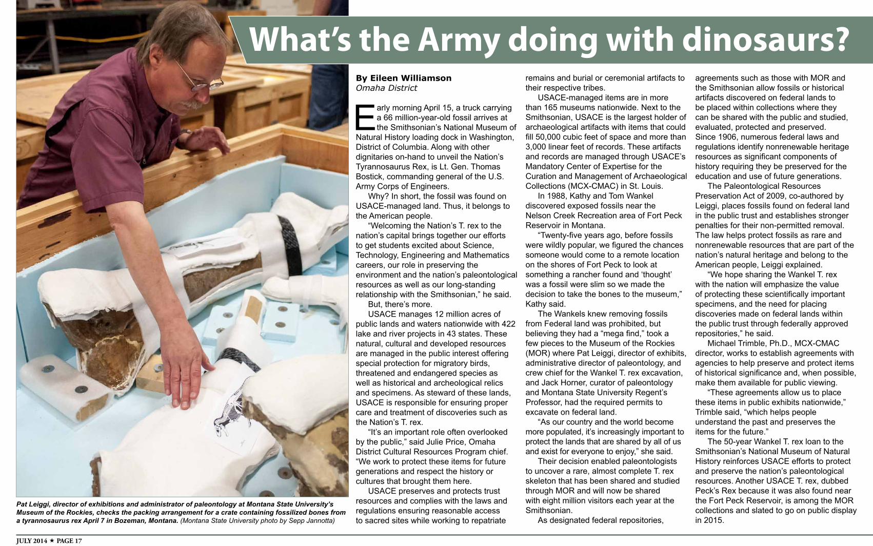
JULY 2014 PAGE 17
Pat Leiggi, director of exhibitions and administrator of paleontology at Montana State University’s Museum of the Rockies, checks the packing arrangement for a crate containing fossilized bones from a tyrannosaurus rex April 7 in Bozeman, Montana. (Montana State University photo by Sepp Jannotta)
By Eileen WilliamsonOmaha District
Early morning April 15, a truck carrying a 66 million-year-old fossil arrives at the Smithsonian’s National Museum of
Natural History loading dock in Washington, District of Columbia. Along with other dignitaries on-hand to unveil the Nation’s Tyrannosaurus Rex, is Lt. Gen. Thomas Bostick, commanding general of the U.S. Army Corps of Engineers.
Why? In short, the fossil was found on USACE-managed land. Thus, it belongs to the American people.
“Welcoming the Nation’s T. rex to the nation’s capital brings together our efforts to get students excited about Science, Technology, Engineering and Mathematics careers, our role in preserving the environment and the nation’s paleontological resources as well as our long-standing relationship with the Smithsonian,” he said.
But, there’s more.USACE manages 12 million acres of
public lands and waters nationwide with 422 lake and river projects in 43 states. These natural, cultural and developed resources are managed in the public interest offering special protection for migratory birds, threatened and endangered species as well as historical and archeological relics and specimens. As steward of these lands, USACE is responsible for ensuring proper care and treatment of discoveries such as the Nation’s T. rex.
“It’s an important role often overlooked by the public,” said Julie Price, Omaha District Cultural Resources Program chief. “We work to protect these items for future generations and respect the history or cultures that brought them here.
USACE preserves and protects trust resources and complies with the laws and regulations ensuring reasonable access to sacred sites while working to repatriate
What’s the Army doing with dinosaurs?remains and burial or ceremonial artifacts to their respective tribes.
USACE-managed items are in more than 165 museums nationwide. Next to the Smithsonian, USACE is the largest holder of archaeological artifacts with items that could fill 50,000 cubic feet of space and more than 3,000 linear feet of records. These artifacts and records are managed through USACE’s Mandatory Center of Expertise for the Curation and Management of Archaeological Collections (MCX-CMAC) in St. Louis.
In 1988, Kathy and Tom Wankel discovered exposed fossils near the Nelson Creek Recreation area of Fort Peck Reservoir in Montana.
“Twenty-five years ago, before fossils were wildly popular, we figured the chances someone would come to a remote location on the shores of Fort Peck to look at something a rancher found and ‘thought’ was a fossil were slim so we made the decision to take the bones to the museum,” Kathy said.
The Wankels knew removing fossils from Federal land was prohibited, but believing they had a “mega find,” took a few pieces to the Museum of the Rockies (MOR) where Pat Leiggi, director of exhibits, administrative director of paleontology, and crew chief for the Wankel T. rex excavation, and Jack Horner, curator of paleontology and Montana State University Regent’s Professor, had the required permits to excavate on federal land.
“As our country and the world become more populated, it’s increasingly important to protect the lands that are shared by all of us and exist for everyone to enjoy,” she said.
Their decision enabled paleontologists to uncover a rare, almost complete T. rex skeleton that has been shared and studied through MOR and will now be shared with eight million visitors each year at the Smithsonian.
As designated federal repositories,
agreements such as those with MOR and the Smithsonian allow fossils or historical artifacts discovered on federal lands to be placed within collections where they can be shared with the public and studied, evaluated, protected and preserved. Since 1906, numerous federal laws and regulations identify nonrenewable heritage resources as significant components of history requiring they be preserved for the education and use of future generations.
The Paleontological Resources Preservation Act of 2009, co-authored by Leiggi, places fossils found on federal land in the public trust and establishes stronger penalties for their non-permitted removal. The law helps protect fossils as rare and nonrenewable resources that are part of the nation’s natural heritage and belong to the American people, Leiggi explained.
“We hope sharing the Wankel T. rex with the nation will emphasize the value of protecting these scientifically important specimens, and the need for placing discoveries made on federal lands within the public trust through federally approved repositories,” he said.
Michael Trimble, Ph.D., MCX-CMAC director, works to establish agreements with agencies to help preserve and protect items of historical significance and, when possible, make them available for public viewing.
“These agreements allow us to place these items in public exhibits nationwide,” Trimble said, “which helps people understand the past and preserves the items for the future.”
The 50-year Wankel T. rex loan to the Smithsonian’s National Museum of Natural History reinforces USACE efforts to protect and preserve the nation’s paleontological resources. Another USACE T. rex, dubbed Peck’s Rex because it was also found near the Fort Peck Reservoir, is among the MOR collections and slated to go on public display in 2015.
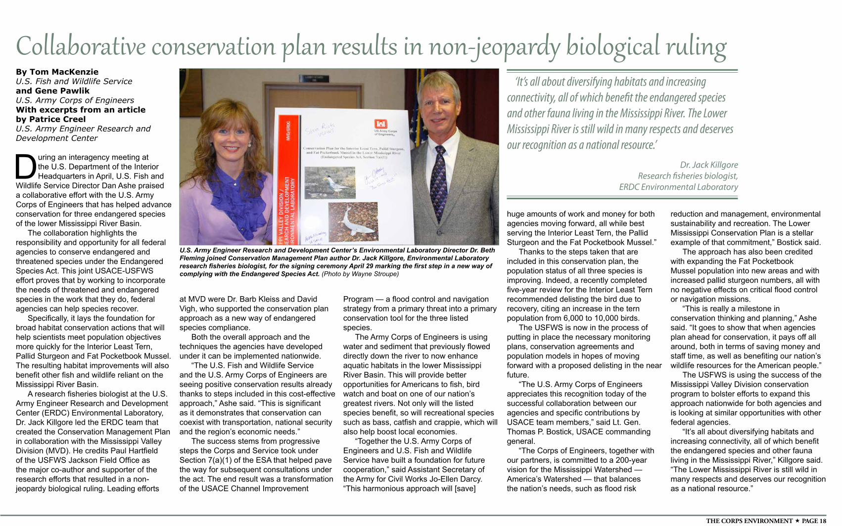
THE CORPS ENVIRONMENT PAGE 18
By Tom MacKenzieU.S. Fish and Wildlife Serviceand Gene Pawlik U.S. Army Corps of EngineersWith excerpts from an article by Patrice CreelU.S. Army Engineer Research and Development Center
During an interagency meeting at the U.S. Department of the Interior Headquarters in April, U.S. Fish and
Wildlife Service Director Dan Ashe praised a collaborative effort with the U.S. Army Corps of Engineers that has helped advance conservation for three endangered species of the lower Mississippi River Basin.
The collaboration highlights the responsibility and opportunity for all federal agencies to conserve endangered and threatened species under the Endangered Species Act. This joint USACE-USFWS effort proves that by working to incorporate the needs of threatened and endangered species in the work that they do, federal agencies can help species recover.
Specifically, it lays the foundation for broad habitat conservation actions that will help scientists meet population objectives more quickly for the Interior Least Tern, Pallid Sturgeon and Fat Pocketbook Mussel. The resulting habitat improvements will also benefit other fish and wildlife reliant on the Mississippi River Basin.
A research fisheries biologist at the U.S. Army Engineer Research and Development Center (ERDC) Environmental Laboratory, Dr. Jack Killgore led the ERDC team that created the Conservation Management Plan in collaboration with the Mississippi Valley Division (MVD). He credits Paul Hartfield of the USFWS Jackson Field Office as the major co-author and supporter of the research efforts that resulted in a non-jeopardy biological ruling. Leading efforts
at MVD were Dr. Barb Kleiss and David Vigh, who supported the conservation plan approach as a new way of endangered species compliance.
Both the overall approach and the techniques the agencies have developed under it can be implemented nationwide.
“The U.S. Fish and Wildlife Service and the U.S. Army Corps of Engineers are seeing positive conservation results already thanks to steps included in this cost-effective approach,” Ashe said. “This is significant as it demonstrates that conservation can coexist with transportation, national security and the region’s economic needs.”
The success stems from progressive steps the Corps and Service took under Section 7(a)(1) of the ESA that helped pave the way for subsequent consultations under the act. The end result was a transformation of the USACE Channel Improvement
huge amounts of work and money for both agencies moving forward, all while best serving the Interior Least Tern, the Pallid Sturgeon and the Fat Pocketbook Mussel.”
Thanks to the steps taken that are included in this conservation plan, the population status of all three species is improving. Indeed, a recently completed five-year review for the Interior Least Tern recommended delisting the bird due to recovery, citing an increase in the tern population from 6,000 to 10,000 birds.
The USFWS is now in the process of putting in place the necessary monitoring plans, conservation agreements and population models in hopes of moving forward with a proposed delisting in the near future.
“The U.S. Army Corps of Engineers appreciates this recognition today of the successful collaboration between our agencies and specific contributions by USACE team members,” said Lt. Gen. Thomas P. Bostick, USACE commanding general.
“The Corps of Engineers, together with our partners, is committed to a 200-year vision for the Mississippi Watershed —America’s Watershed — that balances the nation’s needs, such as flood risk
U.S. Army Engineer Research and Development Center’s Environmental Laboratory Director Dr. Beth Fleming joined Conservation Management Plan author Dr. Jack Killgore, Environmental Laboratory research fisheries biologist, for the signing ceremony April 29 marking the first step in a new way of complying with the Endangered Species Act. (Photo by Wayne Stroupe)
Collaborative conservation plan results in non-jeopardy biological ruling‘It’s all about diversifying habitats and increasing
connectivity, all of which benefit the endangered species and other fauna living in the Mississippi River. The Lower Mississippi River is still wild in many respects and deserves our recognition as a national resource.’
Dr. Jack KillgoreResearch fisheries biologist,
ERDC Environmental Laboratory
reduction and management, environmental sustainability and recreation. The Lower Mississippi Conservation Plan is a stellar example of that commitment,” Bostick said.
The approach has also been credited with expanding the Fat Pocketbook Mussel population into new areas and with increased pallid sturgeon numbers, all with no negative effects on critical flood control or navigation missions.
“This is really a milestone in conservation thinking and planning,” Ashe said. “It goes to show that when agencies plan ahead for conservation, it pays off all around, both in terms of saving money and staff time, as well as benefiting our nation’s wildlife resources for the American people.”
The USFWS is using the success of the Mississippi Valley Division conservation program to bolster efforts to expand this approach nationwide for both agencies and is looking at similar opportunities with other federal agencies.
“It’s all about diversifying habitats and increasing connectivity, all of which benefit the endangered species and other fauna living in the Mississippi River,” Killgore said. “The Lower Mississippi River is still wild in many respects and deserves our recognition as a national resource.”
Program — a flood control and navigation strategy from a primary threat into a primary conservation tool for the three listed species.
The Army Corps of Engineers is using water and sediment that previously flowed directly down the river to now enhance aquatic habitats in the lower Mississippi River Basin. This will provide better opportunities for Americans to fish, bird watch and boat on one of our nation’s greatest rivers. Not only will the listed species benefit, so will recreational species such as bass, catfish and crappie, which will also help boost local economies.
“Together the U.S. Army Corps of Engineers and U.S. Fish and Wildlife Service have built a foundation for future cooperation,” said Assistant Secretary of the Army for Civil Works Jo-Ellen Darcy. “This harmonious approach will [save]