Embed Size (px)
Citation preview
1
Supplementary information
The effect of soils contaminated with fuel‐based hydrocarbons on the
germination and early life stages on Subantarctic plants
Gabriella K Macoustra†, Catherine K. King‡, Jane Wasley ‡, Lauren Wise‡, Sharon Robinsonφ
and Dianne F. Jolley †*
† School of Chemistry, University of Wollongong, NSW 2522, Australia
‡ Australian Antarc c Division, Terrestrial and Nearshore Ecosystems Program, Kingston,
Tasmania, Australia φ School of Biological Sciences, University of Wollongong, NSW 2522, Australia
* To whom correspondence may be addressed ([email protected])
SI Section 1. Macquarie Island and impacts of human activities
Macquarie Island is an isolated subantarctic island located approximately 1,500 km south-south-east of Tasmania and 1,300 km north of Victoria Land, Antarctic (54°30'S, 158°57'E; Figure S1). This places Macquarie Island just north of the Antarctic Convergence or Polar Frontal Zone where the cold, southern polar waters meet the warmer, northern subantarctic waters [1]. Soils and vegetation vary considerably depending on location and vegetation present, with coastal soils being extremely sandy and inland herb field soils consisting of elevated levels of highly organic peat [2]. Soils on the isthmus where the research station is located are principally water-saturated, medium- to coarse-grained sand with little fine material [2]. The extensive damage caused by early exploitation led to Macquarie Island being declared a wildlife sanctuary in 1933 and it was granted World Heritage status in 1988. Despite the cessation of the fur and oil industries and efforts to eradicate introduced pest species, Macquarie Island is still at risk from human activity mainly associated with the Australian National Antarctic Research Expedition (ANARE) station that was established in 1948 and to a lesser extent, seasonal tourists. The human settlement is located on the isthmus that connects Wireless Hill to the northern end of the island and comprises buildings for housing, storage, machinery and waste materials (Figure S2). This permanent occupation at the island’s research station and increased tourism has led to adverse environmental impacts including a number of accidental spills of Special Antarctic Blend (SAB) diesel fuel at and near the research station [2, 3].
Three major spills have been recorded but the first two were not documented at the time and are believed to have occurred before 1994. The most recent and largest spill occurred in 2002 [2]. The fuel spills were significant because of the large volume and relatively high concentrations of spilled fuel [2]. Macquarie Island is protected under the Environment Protection and Biodiversity Conservation Act 1999 and soil remediation to reduce the level of fuel contamination is required to comply with the legislation.
Electronic Supplementary Material (ESI) for Environmental Science: Processes & Impacts.This journal is © The Royal Society of Chemistry 2015

2
Figure S1. Map of subantarctic Macquarie Island. Inset bottom right: Macquarie Island in relation to Australia, New Zealand and Antarctica. Inset top left: the isthmus on which Australia’s research station is located. Image from [4].
Figure S2. Australian research station at Macquarie Island. Photo taken looking north towards Wireless Hill with Hasselborough Bay on the left and Buckles Bay on the right. The fuel spill sites at the Main Powerhouse (top) and Fuel Farm (bottom) are circled in red. Photo by Corrine de Mestre (2013, University of Wollongong, NSW, Australia).
3
SI Section 2. Supplementary results
Rangefinder bioassay, germination success on SAB contaminated soils
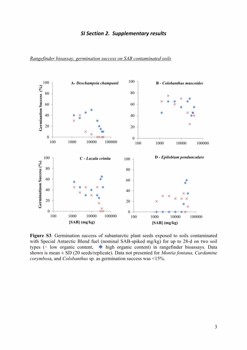
Figure S3. Germination success of subantarctic plant seeds exposed to soils contaminated with Special Antarctic Blend fuel (nominal SAB-spiked mg/kg) for up to 28-d on two soil types (× low organic content, high organic content) in rangefinder bioassays. Data shown is mean ± SD (20 seeds/replicate). Data not presented for Montia fontana, Cardamine corymbosa, and Colobanthus sp. as germination success was <15%.
0
20
40
60
80
100
100 1000 10000 100000
Ger
mia
nti
on S
ucc
ess
(%
) A- Deschampsia champanii
0
20
40
60
80
100
100 1000 10000 100000
B - Colobanthus muscoides
0
20
40
60
80
100
100 1000 10000 100000
Ger
min
atin
on S
ucc
ess
(%)
[SAB] (mg/kg)
C - Luzula crinita
0
20
40
60
80
100
100 1000 10000 100000
[SAB] (mg/kg)
D - Epilobium pendunculare
4
Definitive bioassay, germination success on SAB contaminated soils
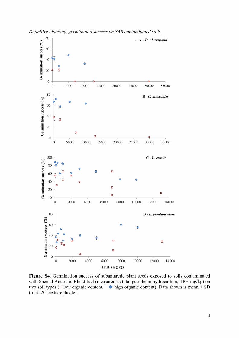
Figure S4. Germination success of subantarctic plant seeds exposed to soils contaminated with Special Antarctic Blend fuel (measured as total petroleum hydrocarbon; TPH mg/kg) on two soil types (× low organic content, high organic content). Data shown is mean ± SD (n=3; 20 seeds/replicate).
A - D. champanii
5
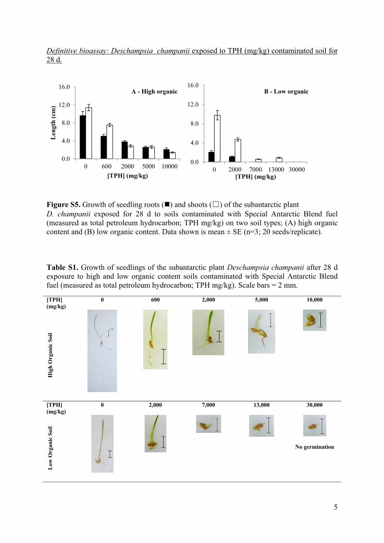
Definitive bioassay: Deschampsia champanii exposed to TPH (mg/kg) contaminated soil for 28 d.
Figure S5. Growth of seedling roots () and shoots (☐) of the subantarctic plant D. champanii exposed for 28 d to soils contaminated with Special Antarctic Blend fuel (measured as total petroleum hydrocarbon; TPH mg/kg) on two soil types; (A) high organic content and (B) low organic content. Data shown is mean ± SE (n=3; 20 seeds/replicate). Table S1. Growth of seedlings of the subantarctic plant Deschampsia champanii after 28 d exposure to high and low organic content soils contaminated with Special Antarctic Blend fuel (measured as total petroleum hydrocarbon; TPH mg/kg). Scale bars = 2 mm.
[TPH] (mg/kg)
0 600 2,000 5,000 10,000
Hig
h O
rgan
ic S
oil
[TPH] (mg/kg)
0 2,000 7,000 13,000 30,000
Low
Org
anic
Soi
l
No germination
0.0
4.0
8.0
12.0
16.0
0 600 2000 5000 10000
Len
gth
(cm
)
[TPH] (mg/kg)
A - High organic
0.0
4.0
8.0
12.0
16.0
0 2000 7000 13000 30000[TPH] (mg/kg)
B - Low organic
6
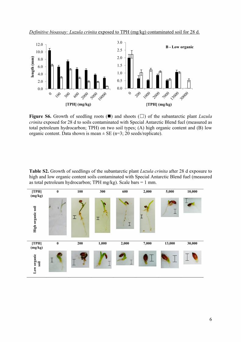
Definitive bioassay: Luzula crinita exposed to TPH (mg/kg) contaminated soil for 28 d.
Figure S6. Growth of seedling roots () and shoots (☐) of the subantarctic plant Luzula crinita exposed for 28 d to soils contaminated with Special Antarctic Blend fuel (measured as total petroleum hydrocarbon; TPH) on two soil types; (A) high organic content and (B) low organic content. Data shown is mean ± SE (n=3; 20 seeds/replicate).
Table S2. Growth of seedlings of the subantarctic plant Luzula crinita after 28 d exposure to high and low organic content soils contaminated with Special Antarctic Blend fuel (measured as total petroleum hydrocarbon; TPH mg/kg). Scale bars = 1 mm.
[TPH] (mg/kg)
0 100 300 600 2,000 5,000 10,000
Hig
h o
rgan
ic s
oil
[TPH] (mg/kg)
0 200 1,000 2,000 7,000 13,000 30,000
Low
org
anic
so
il
0.0
2.0
4.0
6.0
8.0
10.0
12.0
len
gth
(m
m)
[TPH] (mg/kg)
0.0
0.5
1.0
1.5
2.0
2.5
3.0
[TPH] (mg/kg)
B - Low organic
7
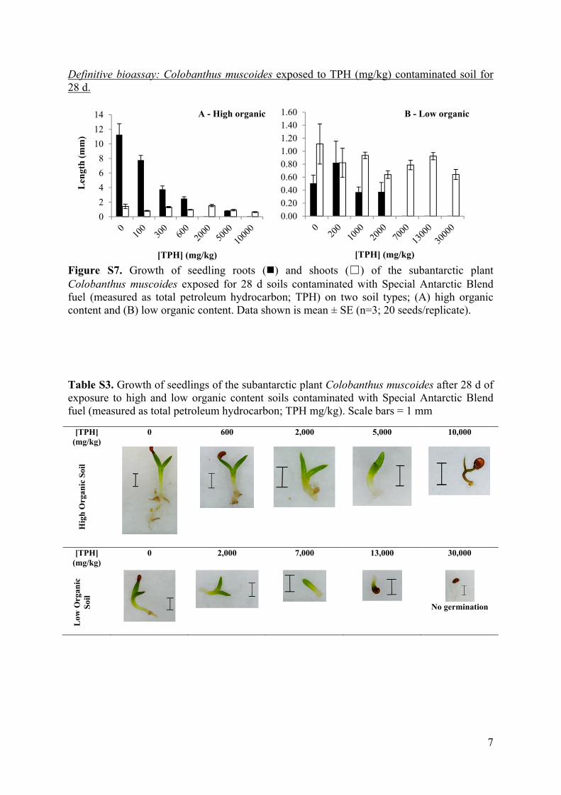
Definitive bioassay: Colobanthus muscoides exposed to TPH (mg/kg) contaminated soil for 28 d.
Figure S7. Growth of seedling roots () and shoots (☐) of the subantarctic plant Colobanthus muscoides exposed for 28 d soils contaminated with Special Antarctic Blend fuel (measured as total petroleum hydrocarbon; TPH) on two soil types; (A) high organic content and (B) low organic content. Data shown is mean ± SE (n=3; 20 seeds/replicate).
Table S3. Growth of seedlings of the subantarctic plant Colobanthus muscoides after 28 d of exposure to high and low organic content soils contaminated with Special Antarctic Blend fuel (measured as total petroleum hydrocarbon; TPH mg/kg). Scale bars = 1 mm
[TPH] (mg/kg)
0 600 2,000 5,000 10,000
Hig
h O
rgan
ic S
oil
[TPH] (mg/kg)
0 2,000 7,000 13,000 30,000
Low
Org
anic
S
oil
No germination
0
2
4
6
8
10
12
14
Len
gth
(m
m)
[TPH] (mg/kg)
A - High organic
0.000.200.400.600.801.001.201.401.60
[TPH] (mg/kg)
B - Low organic

8
Definitive bioassay: Epilobium pendunculare exposed to TPH (mg/kg) contaminated soil for 28 d.
Figure S8. Growth of seedling roots () and shoots (☐) of the subantarctic plant Epilobium pendunculare exposed for 28 d to soils contaminated with Special Antarctic Blend fuel (measured as total petroleum hydrocarbon; TPH mg/kg) on two soil types; (A) high organic content and (B) low organic content. Data is shown as mean ± SE (n=3; 20 seeds/replicate).
Table S4. Growth of seedlings of the subantarctic plant Epilobium pendunculare after 28 d of exposure to low and high organic content soils contaminated with Special Antarctic Blend fuel (measured as total petroleum hydrocarbon; TPH mg/kg). Note purple pigmentation in leaves at higher TPH concentrations. Scale bars = 1 mm.
[TPH] (mg/kg)
0 100 300 600 2,000 5,000 10,000
Hig
h O
rgan
ic S
oil
[TPH] (mg/kg)
0 200 1,000 2,000 7,000 13,000 30,000
Low
org
anic
so
ils
0.00
0.30
0.60
0.90
1.20
1.50
Len
gth
(cm
)
[TPH] (mg/kg)
A - High organic
0.00
0.03
0.06
0.09
0.12
0.15
[TPH] (mg/kg)
B - Low organic

9
Table S5. Summary of 28-d NOEC and LOEC values for root and shoot length of seedlings of subantarctic plants exposed to Special Antarctic Blend fuel. Fuel concentration measured as total petroleum hydrocarbon (TPH, mg/kg).
Endpoint Species Organic Soil type
NOEC (mg/kg)
LOEC (mg/kg)
Root length (mm)
D. champanii High <600 600 Low^ - -
L. crinita High <100* 100* Low <239* 239*
C. muscoides High <600* 600* Low† - -
E. pendunculare High <100 100 Low <2,000 2,000
Shoot length (mm)
D. champanii High <600 600 Low <2,000 2,000
L. crinita High <100 100 Low <200 200
C. muscoides High 10,000 5,000 Low 2,000 7,000
E. pendunculare High <100 100 Low 2,000 2,000
*trends which showed an interrupted does response, the first significant response was taken as the LOEC. †Neither NOEC or LOEC values were calculated as germination was not observed in more than two concentrations.
References
[1] Belkin, IM and Gordon, AL 1996. Southern Ocean fronts from the Greenwich meridian to
Tasmania. Journal of Geophysical Research–Oceans. 101: 3675–3696. [2] Rayner, JL, Snape, I, Walworth, JL, Harvey, PM & Ferguson, SH. 2007. Petroleum-
hydrocarbon contamination and remediation by microbioventing at sub-Antarctic Macquarie Island. Cold Regions Science and Technolog. 48: 139–153.
[3] Schafer, AN, Snape, I & Siciliano, SD. 2007. Soil Biogeochemical Toxicity End Points for Sub-Antarctic Islands Contaminated with Petroleum Hydrocarbons. Environmental Toxicology and Chemistry. 26: 890–897.
[4] Australian Antarctic Division 2008, Macquarie Island map with insets of The Isthmus and Wireless Hill and Macquarie Island in relation to Australia and Antarctica, Hobart. https://data.aad.gov.au/aadc/mapcat/display_map.cfm?map_id=13529