Embed Size (px)
Citation preview
Traffic, Transportation & Safety Action Plan 1 April 13, 2010
Chinatown Working Group
唐人街 工作 小组 Economics and Transportation Working Team 经济和交通运输工作组
Traffic, Transportation and Safety Preliminary Action Plan
Release – April 13, 2010
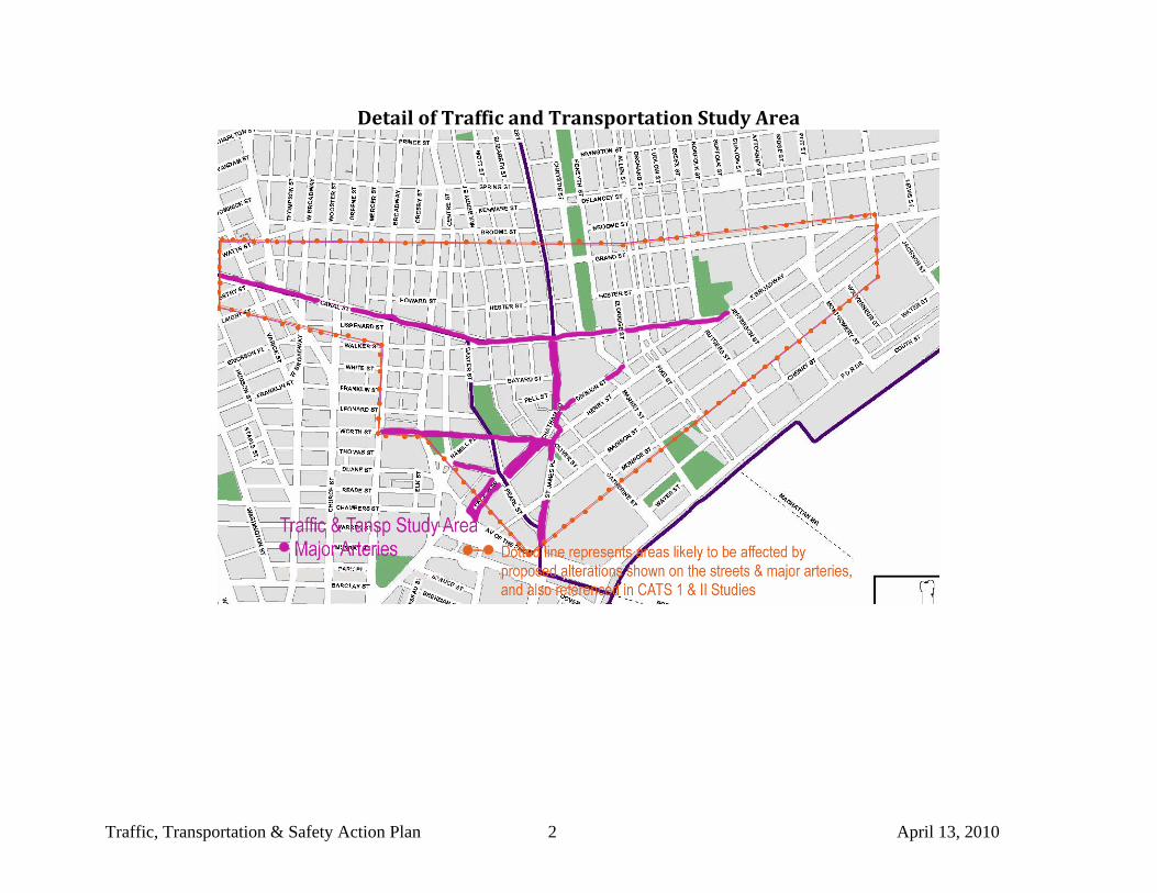
Traffic, Transportation & Safety Action Plan 2 April 13, 2010
Detail of Traffic and Transportation Study Area
Traffic, Transportation & Safety Action Plan 3 April 13, 2010
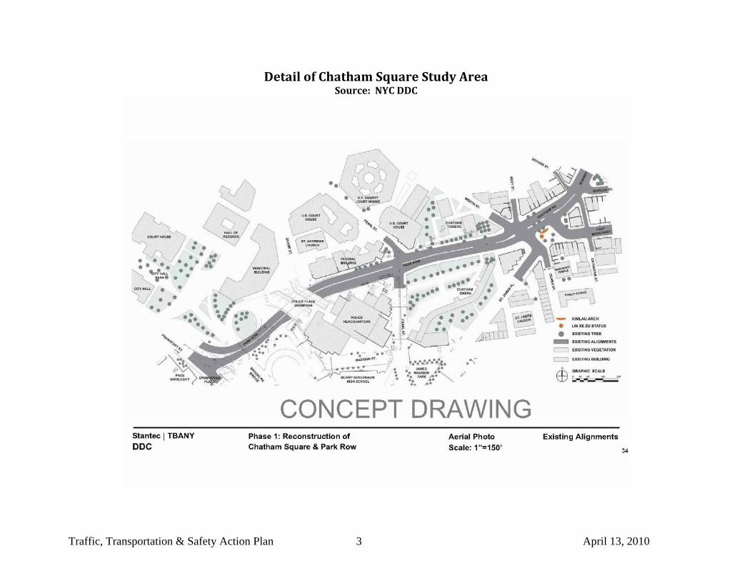
Detail of Chatham Square Study Area Source: NYC DDC
Traffic, Transportation & Safety Action Plan 4 April 13, 2010
Guiding Principles - Parking, Transportation, Circulation, and Safety 1. Strive for a balance in transportation, parking, and security. 2. Foster community input and involvement in vehicular and pedestrian traffic planning and monitoring with an ongoing transparent
process. 3. Advocate for "natural" [holistic] designs and flows; develop improvements to physical layout by taking small steps toward goals that
measure the effectiveness/success/failure at each step and provide opportunity to reassess the path accordingly. 4. Resolving parking and transportation issues:
• Re-establish lost parking, • promote public transportation while easing bus congestion and • plan for private transportation (buses, shuttles, etc) to make it easier for customers to patronize Chinatown businesses, for
residents to travel within their community and for people who have family and other ties to Chinatown throughout the New York Metropolitan Area to congregate and pursue Chinatown traditions and activities related, but not limited, to Chinese-American culture.
• improving pedestrian and cyclist safety,
See Detail of Traffic & Transportation Study Area Map
See also Detail of Chatham Square Study Area Map
Current Condition Goal Agency Coordination and
Research
1. Pedestrian Traffic
Bridge Entrances and Exits – competing priorities between vehicular and pedestrian right-of-ways: Manhattan Bridge, Brooklyn Bridge at Pearl.St./ James Place.
Create Better Pedestrian Spaces
1. Redesign pedestrian/vehicular right of way’s and provide protected pedestrian crossings. 1
a. Manhattan Bridge
NYC AGENCIES: DOT, DCA, DOS, DOH, Parks, LPC, CPC
STATE and Tri-STATE AGENCY: Bridge and Tunnel Authority
FEDERAL AGENCIES: - Canal Area Traffic Study (CATS) I an II. (Get current
1 Feb. 2010 Town Hall – specific request Cantonese Charrette
Traffic, Transportation & Safety Action Plan 5 April 13, 2010
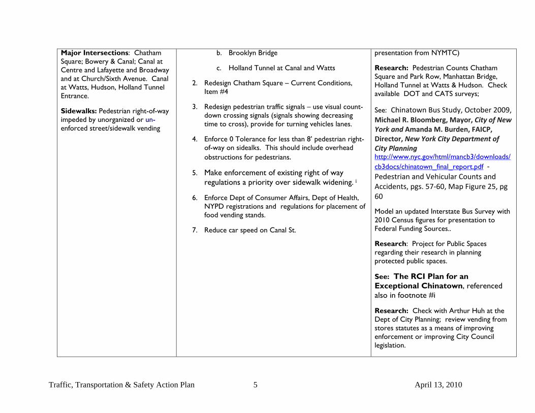
Major Intersections: Chatham Square; Bowery & Canal; Canal at Centre and Lafayette and Broadway and at Church/Sixth Avenue. Canal at Watts, Hudson, Holland Tunnel Entrance.
Sidewalks: Pedestrian right-of-way impeded by unorganized or un-enforced street/sidewalk vending
b. Brooklyn Bridge
c. Holland Tunnel at Canal and Watts
2. Redesign Chatham Square – Current Conditions, Item #4
3. Redesign pedestrian traffic signals – use visual count-down crossing signals (signals showing decreasing time to cross), provide for turning vehicles lanes.
4. Enforce 0 Tolerance for less than 8’ pedestrian right-of-way on sidealks. This should include overhead obstructions for pedestrians.
5. Make enforcement of existing right of way regulations a priority over sidewalk widening. i
6. Enforce Dept of Consumer Affairs, Dept of Health, NYPD registrations and regulations for placement of food vending stands.
7. Reduce car speed on Canal St.
presentation from NYMTC)
Research: Pedestrian Counts Chatham Square and Park Row, Manhattan Bridge, Holland Tunnel at Watts & Hudson. Check available DOT and CATS surveys;
See: Chinatown Bus Study, October 2009, Michael R. Bloomberg, Mayor, City of New York and Amanda M. Burden, FAICP, Director, New York City Department of City Planning http://www.nyc.gov/html/mancb3/downloads/cb3docs/chinatown_final_report.pdf ‐ Pedestrian and Vehicular Counts and Accidents, pgs. 57‐60, Map Figure 25, pg 60
Model an updated Interstate Bus Survey with 2010 Census figures for presentation to Federal Funding Sources..
Research: Project for Public Spaces regarding their research in planning protected public spaces.
See: The RCI Plan for an Exceptional Chinatown, referenced also in footnote #i
Research: Check with Arthur Huh at the Dept of City Planning; review vending from stores statutes as a means of improving enforcement or improving City Council legislation.
Traffic, Transportation & Safety Action Plan 6 April 13, 2010
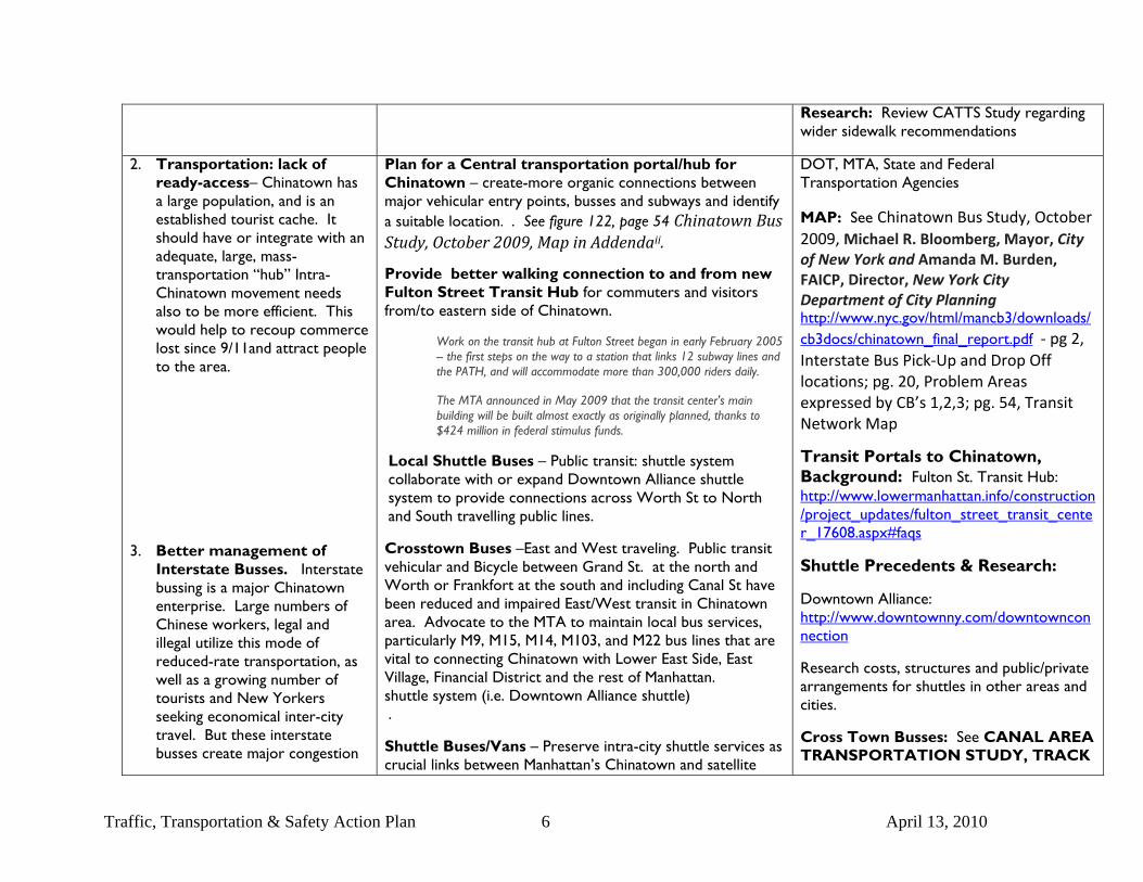
Research: Review CATTS Study regarding wider sidewalk recommendations
2. Transportation: lack of ready-access– Chinatown has a large population, and is an established tourist cache. It should have or integrate with an adequate, large, mass-transportation “hub” Intra-Chinatown movement needs also to be more efficient. This would help to recoup commerce lost since 9/11and attract people to the area.
3. Better management of Interstate Busses. Interstate bussing is a major Chinatown enterprise. Large numbers of Chinese workers, legal and illegal utilize this mode of reduced-rate transportation, as well as a growing number of tourists and New Yorkers seeking economical inter-city travel. But these interstate busses create major congestion
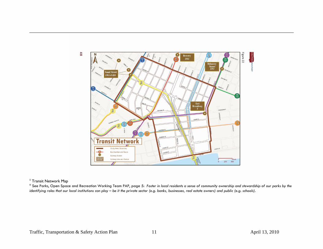
Plan for a Central transportation portal/hub for Chinatown – create-more organic connections between major vehicular entry points, busses and subways and identify a suitable location. . See figure 122, page 54 Chinatown Bus Study, October 2009, Map in Addendaii.
Provide better walking connection to and from new Fulton Street Transit Hub for commuters and visitors from/to eastern side of Chinatown.
Work on the transit hub at Fulton Street began in early February 2005 -- the first steps on the way to a station that links 12 subway lines and the PATH, and will accommodate more than 300,000 riders daily.
The MTA announced in May 2009 that the transit center's main building will be built almost exactly as originally planned, thanks to $424 million in federal stimulus funds.
Local Shuttle Buses – Public transit: shuttle system collaborate with or expand Downtown Alliance shuttle system to provide connections across Worth St to North and South travelling public lines.
Crosstown Buses –East and West traveling. Public transit vehicular and Bicycle between Grand St. at the north and Worth or Frankfort at the south and including Canal St have been reduced and impaired East/West transit in Chinatown area. Advocate to the MTA to maintain local bus services, particularly M9, M15, M14, M103, and M22 bus lines that are vital to connecting Chinatown with Lower East Side, East Village, Financial District and the rest of Manhattan. shuttle system (i.e. Downtown Alliance shuttle) .
Shuttle Buses/Vans – Preserve intra-city shuttle services as crucial links between Manhattan’s Chinatown and satellite
DOT, MTA, State and Federal Transportation Agencies
MAP: See Chinatown Bus Study, October 2009, Michael R. Bloomberg, Mayor, City of New York and Amanda M. Burden, FAICP, Director, New York City Department of City Planning http://www.nyc.gov/html/mancb3/downloads/cb3docs/chinatown_final_report.pdf ‐ pg 2, Interstate Bus Pick‐Up and Drop Off locations; pg. 20, Problem Areas expressed by CB’s 1,2,3; pg. 54, Transit Network Map
Transit Portals to Chinatown, Background: Fulton St. Transit Hub: http://www.lowermanhattan.info/construction/project_updates/fulton_street_transit_center_17608.aspx#faqs
Shuttle Precedents & Research:
Downtown Alliance: http://www.downtownny.com/downtownconnection
Research costs, structures and public/private arrangements for shuttles in other areas and cities.
Cross Town Busses: See CANAL AREA TRANSPORTATION STUDY, TRACK
Traffic, Transportation & Safety Action Plan 7 April 13, 2010
and pollution. Their current frequency on narrow side streets and in major commercial areas for parking and passenger embarking and disembarking increases Chinatown transportation issues.
In addition, more oversight is needed for the proliferation of commuter vans and interstate buses to address noise, pollution, and traffic impacts while recognizing that these modes of transportation are important to the economy of Chinatown’s local businesses and workers.
areas of Sunset Park and Flushing, but support NYC Planning efforts via its Chinatown Bus Study 2009 to regulate the services. Currently, Taxi & Limousine Commission cannot regulate commuter vans with over 20 seats, thus providing a loophole for offenders that operate with egregious violations. Support NYC DOT plans to change regulations to allow more oversight and cull the worse offenders.
Interstate Buses – Recognize that interstate buses provide an important, low-cost mass transit system for Chinatown immigrant workers to distant out-of-state locations for jobs, as well as linkages between other Chinatowns along the Eastern Seaboard to the Midwest. However, State legislation must be passed to empower NYC DOT to regulate bus operations. The worst offenders can be regulated by issuance of curb pickup and drop off times, set locations, scheduled stops, and other permitting schemes. Recommend that the study area boundary for the bus and van lines at the very minimum include the boundary set by the NYC Planning’s Chinatown Bus Study 2009, which is roughly bounded by FDR Drive to the south, Rutgers & Essex St to the east, Grand St to the north, and Centre, Worth, and Catherine Sts to the west. Chinatown Bus Study, Pages 37-40 Long-Term: Investigate underground parking beneath Sarah Roosevelt Park including area just for interstate and tourist buses. Plan for easy access to and from major entry points.
II (CATS II)
http://www.nymtc.org/catsII/files/CATS%20II%20Nov28%20Meetings%20Summary_Feb%2008.pdf, page 4
Inter-State Buses: Interstate Buses – See Chinatown Bus Study, October 2009, Michael R. Bloomberg, Mayor, City of New York and Amanda M. Burden, FAICP, Director, New York City Department of City Planning http://www.nyc.gov/html/mancb3/downloads/cb3docs/chinatown_final_report.pdf ‐
1. Pages 13‐14 outline areas considered for bus depots that have been eliminated from consideration, and why.
2. See also pages 21‐23 for Community Concerns ‐ CB1, CB2, CB3.
3. See Page 33 for recommendations.
Additional References:
NYCDOT’s Chinatown Parking and Access Study; NYCDOT’s Lower Manhattan Street Management; and NYMTC’s Canal Area Transportation Study (CATS).
Traffic, Transportation & Safety Action Plan 8 April 13, 2010
4. Chatham Square/Park Row, Columbus Park – The imposition of adhoc security measures by NYPD headquarters and facilities has failed to accommodate Chinatown. The impact of Park Row closure on vehicular and pedestrian access between Government Center and Chinatown is profound. It cuts off a natural flow of commuters in and out of Chinatown to major public transit hubs; inhibits retail traffic from one of the largest centers of employee commerce in the City.
The affects of planning and development of government buildings has blocked off Chinatown parks, closed streets and radically altered all levels of cultural commerce.
Re-Open Park Row and other access points
The north and eastern parts of Chinatown have been cut off from the south and west due to the presence of municipal and other court buildings. A study is needed to identify a more efficient gateway passage thru to Columbus Park and the center of historic Chinatown and its commercial core. .iii Re-Open Park Row as a means to reconnect Chinatown to City Hall and Financial District. This would solve other conduit problems such as the blockage created by municipal and court buildings near Columbus Park.
Relocate Police Headquarters as per the Environmental Impact Statement, which would aid disaster rapid response time if less vital agencies were concentrated in high-risk areas of Lower Manhattan. Also research relocation of Police Headquarters as a means to address the problem of placard parking in Chinatown, which takes up numerous parking spaces needed for businesses and visitors crucial to the Chinatown economy. Follow-up on CB3 Chatham Square Taskforce recommendations from the City as well as the Community on the best way to fix the traffic flow and increase pedestrian safety in the Chatham Square area. Refer to NYC DOT and Chatham Resident plans.
CPC, DOT, NYPD, City Council, State and Federal Transportation Agencies
Research
DOT/DDC Chatham Square Redevelopment Plan . See Addenda
Brian Ketchum Engineering, PC: ANALYSIS OF COMMUNITY ALTERNATIVES. REVISED February 26, 2009. See Addenda
Page: 8 Find Chatham Green document regarding Chatham Square traffic mitigation plan.
Do a Study regarding the relocation of Police Headquarters to a safer location. Also find the community to the EIS (one pp security plan) and Recommendations from Police Plaza case. (Chatham Green & Chatham Towers)
Traffic, Transportation & Safety Action Plan 9 April 13, 2010
5. Lack of coordination and planning for incoming and outgoing bridge and tunnel traffic.
Create a flexible traffic routing system (including reduced tolls to encourage re-routing for peak or off-hour traffic)
Include Chinatown access as part of an integrated and coordinated lower Manhattan traffic management strategy.
Office of Emergency Management, DOT, Bridge and Tunnel Authority, Federal and State Depts of Transp.
Research: Quantify benefits of Brooklyn Bridge/Park Row entry to Chinatown reopened to traffic.
6. Loss of parking affects businesses (*weekends)…(Police Plaza, Pearl St., Leonard St.). As the vehicular entry point for the Manhattan and Brooklyn Bridges as well as the Holland Tunnel with additional Govt Agency parking needs, the area provides no opportunity for parking vehicles and reducing intra-Borough vehicular traffic.
Re-establish municipal parking. Provide above or below ground parking with better intra Chinatown and Govt Center local transit opportunities.
See also Conditions, Item # 3
Stricter limits and better enforcement of placard parking.
Implement "fast fleet" (as per Washington, DC) system for government agencies/employee car management
Open NYC/STATE parking to public
CPC, DOT,
State and Federal: NYMTC
Research: Study lost parking revenues from the Municipal Garage closure.
What are the potential benefits to the entire Civic Center of having a 1000 car garage (this includes approximately 400 public spaces and 600 NYPD spaces at the Municipal Garage)?
7. Taxis avoid Chinatown (Chatham Square)
Provide mandated Taxi-Stand areas. Possible coordination with pedestrian mall or seating areas and with municipal parking locations
Taxi & Limousine Commission, DOT
8. Too much Commercial Traffic - truck traffic on Canal St. (health problems, safety issues). This has unfairly burdened Chinatown.
Change toll structure on Verrazano Bridge
Dis-incentivize access by large trucks (Higher tolls for larger vehicles, defined local delivery hours ?)
Federal Dept of Transportation, State Dept of Transp., Bridge and Tunnel Auth.
Research: NYMTC/CATS
9. Need better coordination between local residents and businesses with City agencies in ongoing improvement planning
Foster community input and involvement in vehicular and pedestrian traffic planning and monitoring in an ongoing transparent process. (Community Benefit District, LCD Structure?)
DOT, CAU, CPC
Traffic, Transportation & Safety Action Plan 10 April 13, 2010
i The RCI Plan for an Exceptional Chinatown, “Prosperity and Longevity” includes sidewalk widening aspects: Chinatown Main Streets: East Broadway, Division, East Canal, Grand. As Chinatown has grown, so has its other shopping districts. These now address the shopping needs not only of local residents, but also suburban and outer-borough Chinese-Americans. These districts include Grand Street, East Broadway, East Canal Street, and Upper Mott Street.
The most important of these “Main Streets” is East Broadway---the main center of the Fukienese ethnic group, and a major destination thanks to the regional buses and vans that stop nearby. East Broadway’s biggest problem is simply congestion: there are too few cross streets for easy circulation; too narrow sidewalks for pedestrians; and too little parking for convenience. The plan envisions mid-block crossings, through street arcades to Division and Henry, a night Market below the Manhattan Bridge, new pedestrian-scaled lighting, bump-outs at the corners, sidewalk widening, street trees, added parking along Allen Street – all of the ingredients of a successful “Main Street” program." -
Traffic, Transportation & Safety Action Plan 11 April 13, 2010
ii Transit Network Map iii See Parks, Open Space and Recreation Working Team PAP, page 5: Foster in local residents a sense of community ownership and stewardship of our parks by the identifying roles that our local institutions can play – be it the private sector (e.g. banks, businesses, real estate owners) and public (e.g. schools).
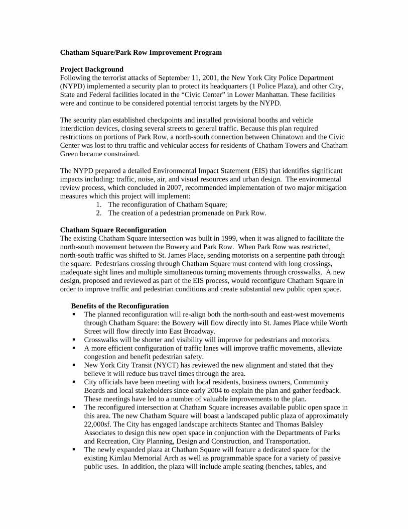
Chatham Square/Park Row Improvement Program Project Background Following the terrorist attacks of September 11, 2001, the New York City Police Department (NYPD) implemented a security plan to protect its headquarters (1 Police Plaza), and other City, State and Federal facilities located in the “Civic Center” in Lower Manhattan. These facilities were and continue to be considered potential terrorist targets by the NYPD. The security plan established checkpoints and installed provisional booths and vehicle interdiction devices, closing several streets to general traffic. Because this plan required restrictions on portions of Park Row, a north-south connection between Chinatown and the Civic Center was lost to thru traffic and vehicular access for residents of Chatham Towers and Chatham Green became constrained. The NYPD prepared a detailed Environmental Impact Statement (EIS) that identifies significant impacts including: traffic, noise, air, and visual resources and urban design. The environmental review process, which concluded in 2007, recommended implementation of two major mitigation measures which this project will implement:
1. The reconfiguration of Chatham Square; 2. The creation of a pedestrian promenade on Park Row.
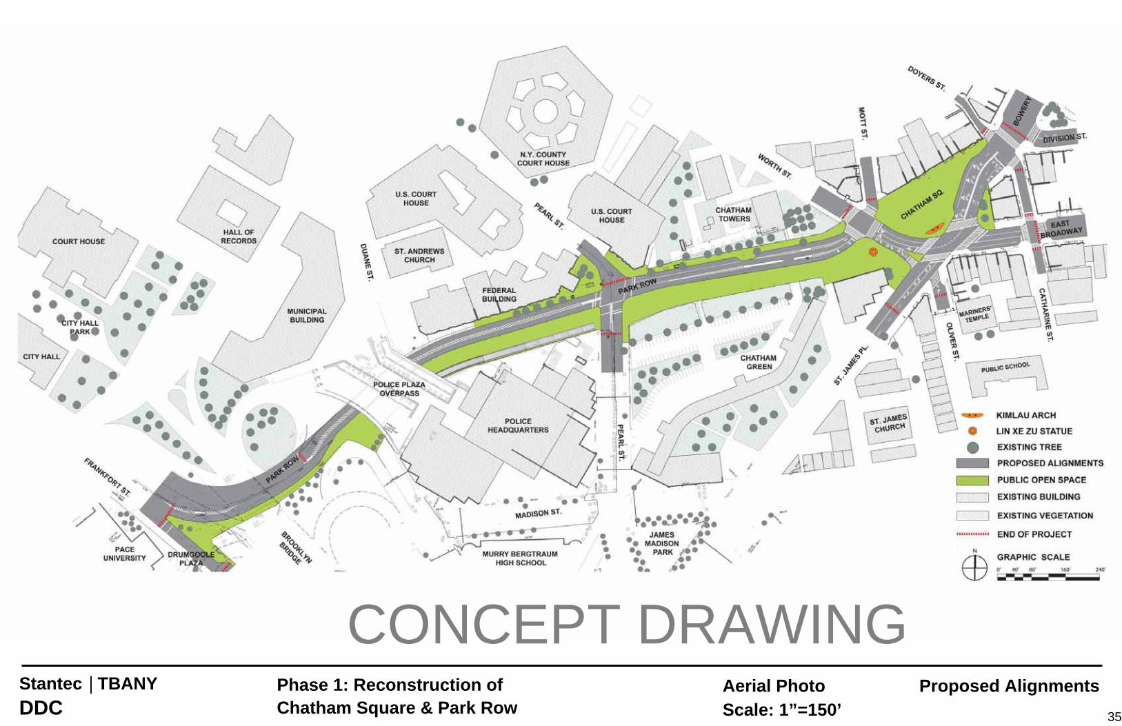
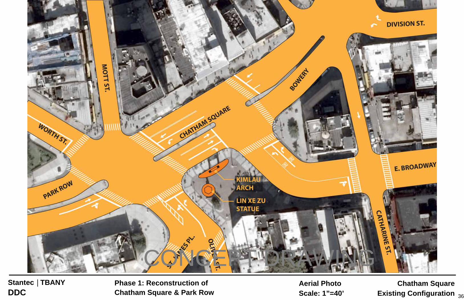
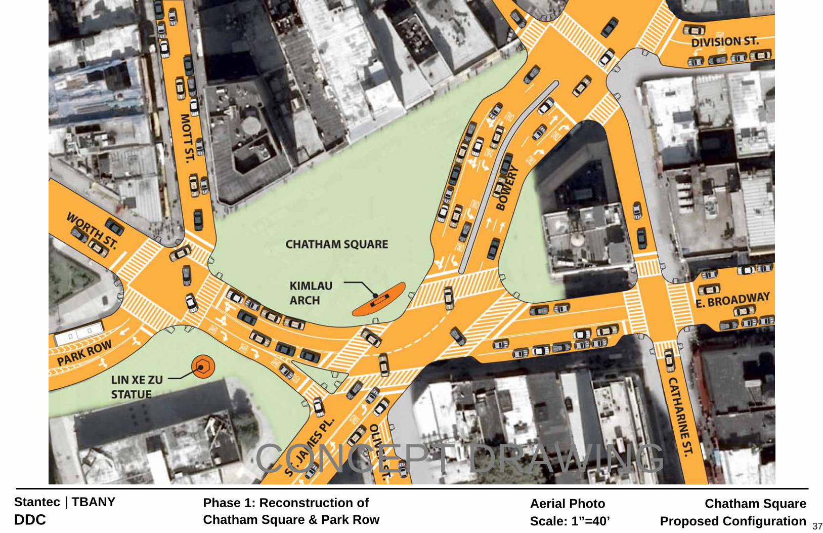
Chatham Square Reconfiguration The existing Chatham Square intersection was built in 1999, when it was aligned to facilitate the north-south movement between the Bowery and Park Row. When Park Row was restricted, north-south traffic was shifted to St. James Place, sending motorists on a serpentine path through the square. Pedestrians crossing through Chatham Square must contend with long crossings, inadequate sight lines and multiple simultaneous turning movements through crosswalks. A new design, proposed and reviewed as part of the EIS process, would reconfigure Chatham Square in order to improve traffic and pedestrian conditions and create substantial new public open space. Benefits of the Reconfiguration
The planned reconfiguration will re-align both the north-south and east-west movements through Chatham Square: the Bowery will flow directly into St. James Place while Worth Street will flow directly into East Broadway.
Crosswalks will be shorter and visibility will improve for pedestrians and motorists. A more efficient configuration of traffic lanes will improve traffic movements, alleviate
congestion and benefit pedestrian safety. New York City Transit (NYCT) has reviewed the new alignment and stated that they
believe it will reduce bus travel times through the area. City officials have been meeting with local residents, business owners, Community
Boards and local stakeholders since early 2004 to explain the plan and gather feedback. These meetings have led to a number of valuable improvements to the plan.
The reconfigured intersection at Chatham Square increases available public open space in this area. The new Chatham Square will boast a landscaped public plaza of approximately 22,000sf. The City has engaged landscape architects Stantec and Thomas Balsley Associates to design this new open space in conjunction with the Departments of Parks and Recreation, City Planning, Design and Construction, and Transportation.
The newly expanded plaza at Chatham Square will feature a dedicated space for the existing Kimlau Memorial Arch as well as programmable space for a variety of passive public uses. In addition, the plaza will include ample seating (benches, tables, and
chairs), extensive plantings and street trees providing a refuge for pedestrians, and a water feature that will act as a focal point for the Square.
Park Row Promenade
The existing configuration of Park Row permits two lanes of through traffic plus a parking lane in each direction. Now that Park Row is restricted to authorized vehicles (local residents, NYPD vehicles, NYCT buses and emergency services), this roadway is underutilized.
Nearly 50% of the right-of-way for vehicles is planned for conversion as a landscaped promenade for pedestrians and bicyclists. The promenade will feature: o An array of appropriate trees and plantings; o A landscaped path linking Chinatown to the Civic Center and Lower Manhattan
that can accommodate pedestrians and bicyclists; o Passive recreation space; and o A new location for the Commissioner Lin Xe Zu statue near the northern
terminus of Park Row (this location was identified with input from the Lin Xe Zu Foundation).
Between Pearl Street and the 1PP Plaza, the project proposes to construct a pedestrian ramp that will provide a direct pedestrian link from the Civic Center / One Police Plaza to Park Row, including the City Hall subway station. This ramp will provide an important connection to and from Chinatown that currently does not exist.
The plan for Park Row also features improvements to the existing “sallyport” security configuration at its northern entrance (near Worth St). These improvements will mobility for residents and MTA buses that pass through the checkpoint and will provide upgrade the security devices to improve aesthetics and reduce visual and noise impacts.
Small Business Assistance Program Businesses may be eligible for assistance through the Small Business Assistance Program established by the Lower Manhattan Development Corporation in Cooperation with the Small Business Services and the New York City Economic Development Corporation. More information can be found at: http://www.renewnyc.com/ProjectsAndPrograms/small_firms.asp Project Schedule The schedule for the Chatham Square / Park Row Improvements project will coordinate with the Brooklyn Bridge Rehabilitation Project, which will require traffic to be detoured to the Manhattan Bridge and through the Chatham Square intersection. The Brooklyn Bridge project is scheduled to begin in mid-2010, and the Chatham Square intersection realignment and related utility work needs to start construction one year ahead of the Brooklyn Bridge project.
Chatham Square intersection re-alignment and related utility work Target construction start: Mid-2009 Expected duration: Late 2011
Chatham Square Landscaping, Park Row Promenade and Pedestrian Ramp (concurrent with Brooklyn Bridge) Target construction start: Early 2010 Expected completion: Mid-2011
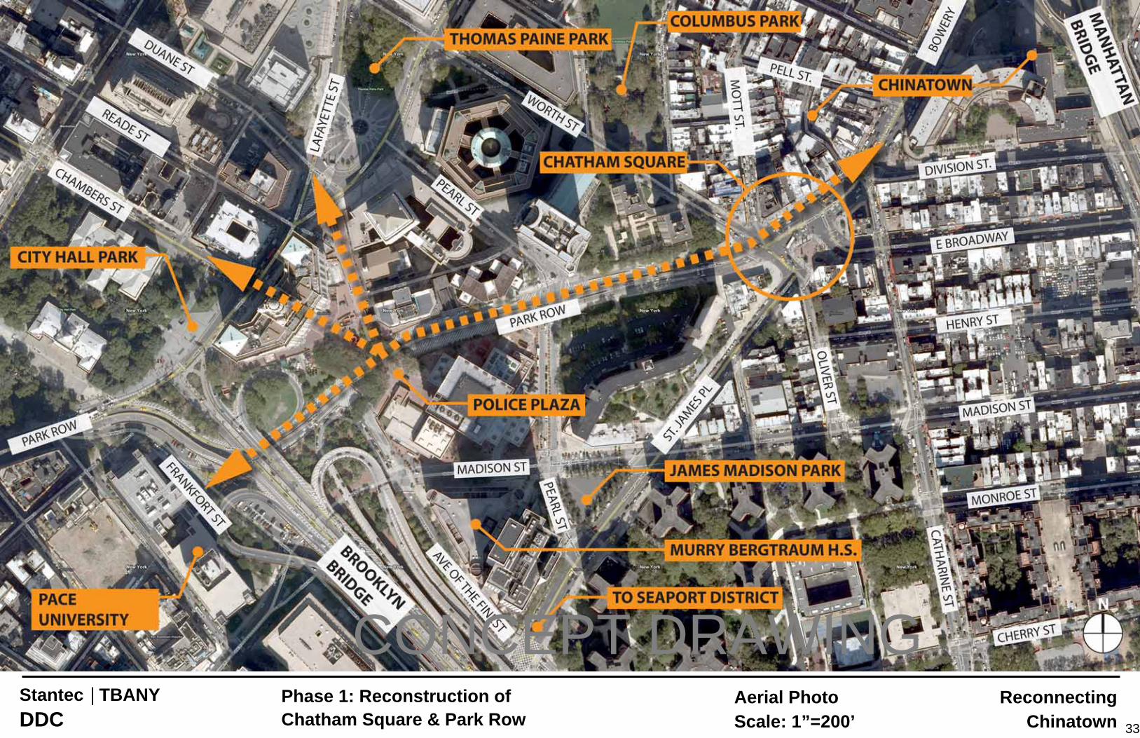
33
Reconnecting Chinatown
Aerial PhotoScale: 1”=200’
Stantec | TBANY DDC
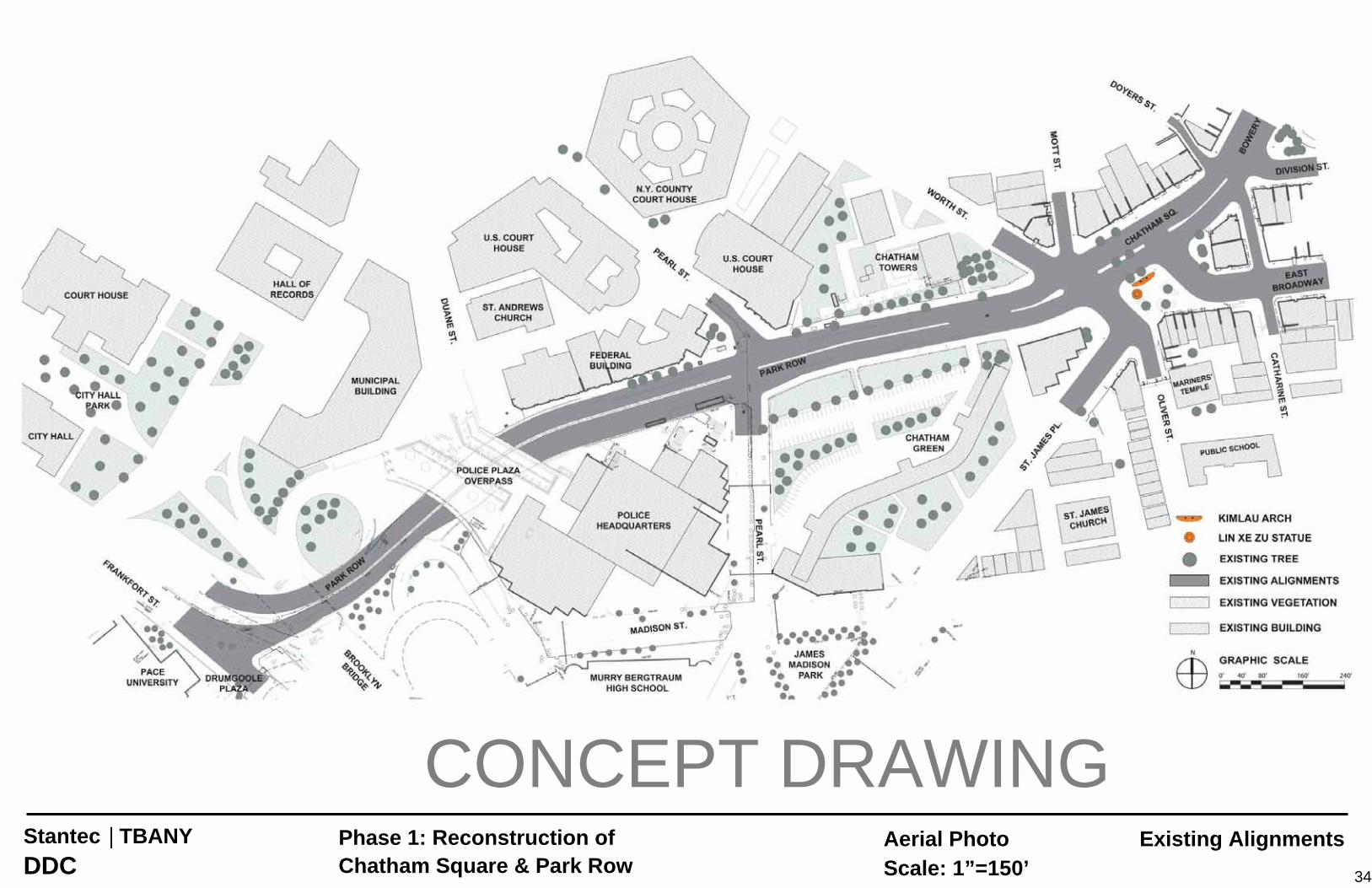
Phase 1: Reconstruction of Chatham Square & Park Row
CONCEPT DRAWING
34
Existing AlignmentsAerial PhotoScale: 1”=150’
Stantec | TBANY DDC
Phase 1: Reconstruction of Chatham Square & Park Row
CONCEPT DRAWING
35
Proposed AlignmentsAerial PhotoScale: 1”=150’
Stantec | TBANY DDC
Phase 1: Reconstruction of Chatham Square & Park Row
CONCEPT DRAWING
36
Chatham SquareExisting Configuration
Aerial PhotoScale: 1”=40’
Stantec | TBANY DDC
Phase 1: Reconstruction of Chatham Square & Park Row
CONCEPT DRAWING
37
Aerial PhotoScale: 1”=40’
Chatham SquareProposed Configuration
Stantec | TBANY DDC
Phase 1: Reconstruction of Chatham Square & Park Row
CONCEPT DRAWING
1
BRIAN KETCHAM ENGINEERING, PC 175 Pacific Street, Brooklyn, NY 11201, 718-330-0550
MEMORANDUM ANALYSIS OF COMMUNITY ALTERNATIVES
REVISED February 26, 2009
Representatives from the Chinatown community have suggested a number of alternative configurations and refinements to the Chatham Square reconstruction. This technical memorandum summarizes an analysis of three proposals designed to improve pedestrian safety at the dangerous intersection of Olive Street and St. James Place and to facilitate traffic flow through Chatham Square. The three proposals examined are:
1. A connecting link from St. James Place to E. Broadway (Alternative A) 2. A connecting link from St. James Place to the intersection of Bowery and E. Broadway
(Alternative B) 3. A pedestrian crossing on St. James Place south of Oliver Street with each of the above.
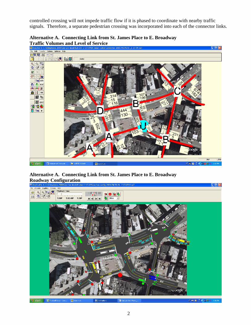
A Synchro traffic simulation model of the entire immediate area was developed using traffic data for baseline weekday PM peak hour conditions provided by Phillip Habib Associates that was used in their analysis of the Chatham Square reconstruction. It does not consider the diversion that might occur with the reconstruction of the Brooklyn Bridge. Baseline vehicle trips were redistributed for each option on the basis of baseline travel patterns. Signal phasing was optimized for baseline conditions and unchanged for the alternatives (except for the intersection of Bowery/E. Broadway with the introduction of a diagonal connector (Alt. B)); signal cycle time and the distribution of green time were optimized to achieve the best operating conditions for each alternative. All alternatives in the following figures are compared in the concluding table. Alternative A. Connecting Link from St. James Place to E. Broadway. This connecting link is assumed to be one-way northbound with a stop-controlled entrance to E. Broadway. Because the link enters E. Broadway midblock, it would be difficult and disruptive to permit E. Broadway WB trips to make a left turn. The link is assumed to be 14 feet in width (one moving lane). Alternative B. Connecting Link from St. James Place to Intersection of E. Broadway and Bowery Street. This is another interpretation of the proposed community alternative. It too is one-way northbound. During the modeling, attempts to provide two-way operation were made, but turns from E. Broadway and Bowery onto this added road were impossible to accommodate without producing area-wide breakdown conditions. This connecting link was assumed to be two lanes NB. Again, trips were redistributed on the basis of existing travel patterns. Pedestrian Crossing South of Oliver Street. The simulation for both alternatives assumes a signalized pedestrian crossing south of Oliver Street. The hazard at St. James Place and Oliver Street is that drivers of cars and trucks traveling south on St. James cannot easily see pedestrians crossing at the existing uncontrolled crossing. Adding a signal alone does not fully solve the sight distance problem. By moving the pedestrian crossing approximately 100 feet south between Oliver and James Streets, protected by a signal, pedestrians crossing St. James would be much safer. A barrier may be needed at Oliver Street to get pedestrians to walk out of their way to make the crossing and not jay-walk across St. James Place to save a little time. Providing a mid-block signal
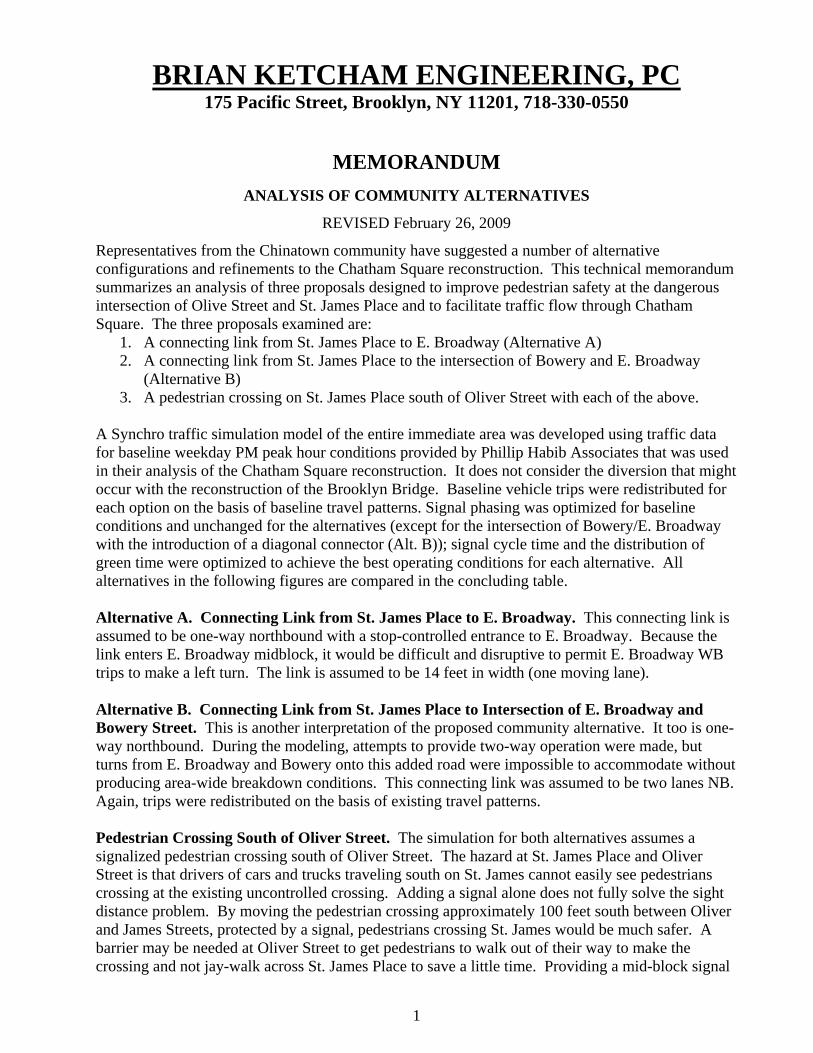
controlled crossing will not impede traffic flow if it is phased to coordinate with nearby traffic signals. Therefore, a separate pedestrian crossing was incorporated into each of the connector links. Alternative A. Connecting Link from St. James Place to E. Broadway Traffic Volumes and Level of Service
Alternative A. Connecting Link from St. James Place to E. Broadway Roadway Configuration
2
Alternative B. Connecting Link from St. James Place to the Intersection of Bowery and E. Broadway Traffic Volumes and Level of Service
Alternative B. Connecting Link from St. James Place to the Intersection of Bowery and E. Broadway Roadway Configuration
3
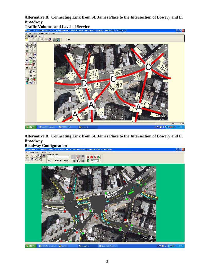
Baseline Conditions (No Build) Traffic Volumes and Level of Service
Baseline Conditions (No Build) Roadway Configuration Assumed for Baseline Conditions
4
5
Comparison of Operating Conditions A comparison of operating conditions for the two community scenarios with baseline conditions is shown in the table below. It is assumed for this analysis that no parking would be allowed on either proposed connector. A traffic signal was assumed for the intersection of Oliver Street with St. James Place for all comparisons. The two intersections that are compared are Worth Street at the Bowery (Chatham Square) and Bowery and E. Broadway. They are both impacted by the proposed actions. Since the first draft of this report dated February 15, 2009, we have improved the operation of the Synchro network shown in the above figures. Refinements of the signal phasing, timing and cycle times have produced somewhat different results than earlier reported, especially for Alternative B with the diagonal connection between St. James Place and the intersection of the Bowery with E. Broadway. The additional modeling demonstrates, based on the assumed traffic volumes that the diagonal alternative (Alt. B) shows similar, but better performance of the cross connector (Alt. A) as reported earlier. Alternative A. Operating conditions for the alternative assuming a direct connection between St. James Place and E. Broadway appears to provide significantly better traffic flow at the intersection of Worth and Bowery and little change at the intersection of Bowery and E. Broadway. Overall Level of Service (LOS) for the Worth Street/Bowery/St. James intersection improves from a LOS F with 74 seconds of average vehicle delay to LOS D with 47 seconds of delay. For the intersection of the Bowery with E. Broadway, LOS does not change from existing conditions, remaining at LOS B with 11 seconds of delay. The table below shows considerable improvement at two approaches and slight deterioration at two approaches to Worth St/Bowery/St. James Place for Alt. A. The St. James Pl. northbound right turn improves from LOS F with 107 seconds of delay to LOS F with 87 seconds of delay. The Bowery St. southbound right turn improves from LOS F with 129 seconds of delay to LOC C with 30 seconds of delay. However, the Mott Street left and right turn movements deteriorate somewhat more, from LOS D with 43 seconds of a delay to LOS D with 50 seconds of delay for the right turn and from LOS D with 46 seconds of delay to LOS E with 62 seconds of delay for the left turn. Alternative B. The second alternative analyzed is the direct diagonal connection from St. James Pl. to the intersection of the Bowery with E. Broadway. This alternative achieves a slightly better 7overall LOS of D with 44 seconds of delay compared to overall LOS of D with 47 seconds delay for Alt. A discussed above. Again, there are some gains and some losses for certain intersection approaches. The St. James Pl. northbound right turn at the Bowery improves from LOS C with 34 seconds of delay compared to LOS F with 87 seconds of delay for Alt. A from St. James Pl. to the new E. Broadway stop-controlled intersection. Only one location exhibits significant losses: the Bowery southbound right turn deteriorates from LOS C with 30 seconds of delay (Alt. B) to LOS E with 72 seconds of delay (Alt. A) but is an improvement over the existing 107 seconds of delay for Baseline conditions. The Mott St. southbound left turn movement which exhibits LOS E for both alternatives but deteriorates from 62 to 69 seconds of delay. Adding a signal-protected pedestrian crossing to St. James Place to either alternative will not adversely affect traffic movement along St. James Place. Conclusions Refined traffic modeling shows that both community alternatives, a new road connecting St. James Place either directly with East Broadway (Alt. A) or diagonal with Bowery Street (Alt. B) would improve existing conditions to a similar degree at the Worth St./Bowery/St. James Place intersection, improving the overall existing Level of Service E with 74 seconds delay to LOS D with either 47 (Alt. A) or 44 (Alt. B) seconds of delay. However, at the Bowery/E. Broadway
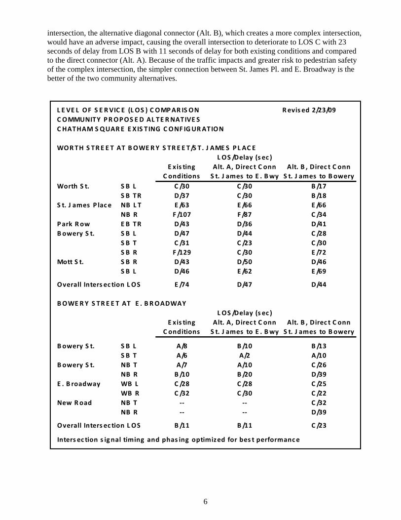
intersection, the alternative diagonal connector (Alt. B), which creates a more complex intersection, would have an adverse impact, causing the overall intersection to deteriorate to LOS C with 23 seconds of delay from LOS B with 11 seconds of delay for both existing conditions and compared to the direct connector (Alt. A). Because of the traffic impacts and greater risk to pedestrian safety of the complex intersection, the simpler connection between St. James Pl. and E. Broadway is the better of the two community alternatives.
L E VE L OF S E RVIC E (L OS ) C OMPAR IS ON Revis ed 2/23/09C OMMUNITY PROPOS E D AL TE RNATIVE SC HATHAM S QUARE E XIS TING C ONF IGURATION
WORTH S TR E E T AT BOWERY S TR E E T/S T. J AME S PL AC EL OS /Delay (s ec )
E xis ting Alt. A, Direc t C onn Alt. B , Direc t C onnC onditions S t. J ames to E . Bwy S t. J ames to Bowery
Worth S t. S B L C /30 C /30 B /17S B TR D/37 C /30 B /18
S t. J ames P lace NB L T E /63 E /66 E /66NB R F /107 F /87 C /34
Park Row E B TR D/43 D/36 D/41Bowery S t. S B L D/47 D/44 C /28
S B T C /31 C /23 C /30S B R F /129 C /30 E /72
Mott S t. S B R D/43 D/50 D/46S B L D/46 E /62 E /69
Overall Inters ec tion L OS E /74 D/47 D/44
BOWERY S TR E E T AT E . BROADWAYL OS /Delay (s ec )
E xis ting Alt. A, Direc t C onn Alt. B , Direc t C onnC onditions S t. J ames to E . Bwy S t. J ames to Bowery
Bowery S t. S B L A/8 B /10 B /13S B T A/6 A/2 A/10
Bowery S t. NB T A/7 A/10 C /26NB R B /10 B /20 D/39
E . B roadway WB L C /28 C /28 C /25WB R C /32 C /30 C /22
New Road NB T ‐‐ ‐‐ C /32NB R ‐‐ ‐‐ D/39
Overall Inters ec tion L OS B /11 B /11 C /23
Inters ec tion s ignal timing and phas ing optimized for bes t performance
6