Embed Size (px)
Citation preview

Journalof volcanology and geothermal research
ELSEVIER Journal of Volcanology and Geothermal Research 91 (1999) 1-21 www .elsevier.com/locate/jvolgeores
Tungurahua Volcano, Ecuador: structure, eruptive history and I hazards Minard L. Hall a*1, Claude Robin b. * , Bernardo Beate ', Patricia Mothes a.1,
Michel Monzier a*d,2
a lnstifrtto Geojïsico, Escuela Politécnica Nacional, P.O. Box 1701 -2759, Qriito. Ecuador lnstirut de Recherches Pour le Déceloppement (IRD, ex-ORSTOMI. UR 6, OPGC, 5 Rue Kessler, 63038. Clermont-Ferrand. France Departantento de Geología. Facultad de Geologia. Minas y Petróleos, Escuela Politecnica Nacional. P.O. Box I701 -2759. Quito,
Ecuador Institiit de Recherches pour le Déceloppement IIRD, ex-ORSTOMI. UR 6, A.P. 17-1 1-6596, Quit;. Ecuador
Accepted 23 March 1999 I I
Abstract l Tungurahua, one of Ecuador's most active volcanoes, is made up of threc volcanic edifices. Tungurahua I was a
14-km-wide andesitic stratocone which experienced at least one sector collapse followed by the extrusion of a dacite lava series. Tungurahua II, mainly composed of acid andesite lava flows younger than 14,000 years BP, was partly destroyed by the last collapse event. 7955 f 90 years ago, which left a large amphitheater and produced a - 8 - h 3 debris deposit. The avalanche collided with the high ridge immediately to the west of the cone and was diverted to the northwest and southwest for - 15 km. A large lahar formed during this event, which was followed in turn by dacite extrusion. Southwestward, the damming of the Chambo valley by the avalanche deposit resulted in a - 10-km-long lake, which was subsequently breached. generating another catastrophic debris flow. The eruptive activity of the present volcano (Tungurahua III) has rebuilt the cone to about 50% of its pre-collapse size by the emission of - 3 km3 of volcanic products. Two periods of construction are recognized in Tungurahua's III history. From - 2300 to - 1400 years BP, high rates of lava extrusion and pyroclastic flows occurred. During this period, the magma composition did not evolve significantly, remaining essentially basic andesite. During the last - 1300 years, eruptive episodes take place roughly once per century and generally begin with lapilli fall and pyroclastic flow activity of varied composition (andesite 4- dacite), and end with more basic andesite lava tlows or crater plugs. This pattern is observed in the three historic eruptions of 1773, 1886 and 1916-1918. Given good age control and volumetric considerations, Tungurahua III growth's rate is estimated at - 1.5 X lo6 m3/year over the last 2300 years. Although an infrequent event, a sector collapse and associated lahars constitute a strong hazard of this volcano. Given the - 3000 m relief and steep slopes of the present cone, a future collapse, even of small volume, could cover an area simil? to that affected by the - 3000-year-old avalanche. The more frequent eruptive episodes of each century,
' Corresponding author. E-mail: [email protected] ' E-mail: [email protected]. ' E-mail: geotï[email protected], [email protected].
0377-0273/99/% - see front matter Q 1999 Elsevier Science B.V. All rights reserved. PII: S 03 7 7 -0 27 3(9 9 )00047-5
I - _-----
Fonds Documentaire OWSTOM

2 ML. Hail et al./Joumal of Volcanology and Geothermal Research 91 (19991 1-21
characterized by pyroclastic flows, lavas, lahars. as well as tephra falls, directly threaten 25,000 people and the Agoyan hydroelectric dam located at the foot of the volcano. O 1999 Elsevier Science B.V. All rights reserved.
Keywords: Andesite magmatism: Debris avalanche and dam: Magma flux rate: Hazards: Tungurahua Volcano; Ecuador
1. Introduction
Tungurahua Volcano (Lat. 01'28's; Long. 78'27'W) is located on the Eastern Cordillera of the Ecuadorian Andes, 120 km south of Quito and 33 km southeast of Ambato, the capital of Tungurahua Province (Fig. 1). This 5023-m-high active volcano is notable for its extreme relief (3200 m), steep sides, and small summit glacier. Along with other large active volcanoes such as Cotopaxi, Sangay, Antisana and Cayambe, it defines the eastern volcanic row in
Ecuador, some 35 km behind the volcanic front that lies on the Western Cordillera.
Early geological and petrographical descriptions of Tungurahua were given by Reiss (1874), Stübel (1886). Wolf (1892) and Reiss and Stübel (1904). More modern studies of the volcano and its hazards were carried out by Salazar (1977), Hall and Vera (1985, Hall and Hillebrandt (1988) and Almeida and Ramon (1991). According to the catalogue of active volcanoes (Simkin and Siebert, 19941, this volcano has experienced 17 eruptions since its discovery in
I
1 Soche 10 Antisdna 2 Cotacachi-Ciicocha 11 Sumaco 3 Mojanda-Fuya Fuya 12 llliniza
5 Cayambe 14 Chalupas 6 Reventador caldera 7 Pichincha 15 Quilotoa 8 Chacana caldera 16 Sagoatoa 9 Atacazo 17 Chimborazo
4 Pululagua 13 Cotopaxi
78"OoW
18 Tungurahua 19 Altar 20 Sangay
u Caldera - Fautt
Fig. 1. Location of Tungurahua Volcano. The names of the 20 main Quaternary volcanic edifices are given.

ML. Hall et aL/Journal of Volcanology and Georhennal Research 91 (1999) 1-21 3
1532, 10 of them being uncertain. Four major erup- tive episodes are recognized by historical reports: in 1641-1646, 1773-1781, 1886-1888 and 1916- 1918, the former needing to be confirmed. In total, they amount to seven major emissions of lava, pyro- clastic flows and fallout tephra. The development and consequences of the two largest historic erup- tions, those of 1886 and 1916-1918, were described in considerable detail by A. Martinez (1886) and N. Martinez ( 1932). Additionally, crater explosions oc- curred in 1797, coinciding with the earthquake that destroyed nearby Riobamba. Increased fumarolic ac- tivity was reported in 1857, and in 1873, 1877, 1883 and 1885, apparently preceding the eruption of 1886. After the 1916-1918 eruptive period, important fu- marolic activity continued until 1925. Fumaroles still exist along the northern edge of the present summit crater (150-200 m in diameter and 50 m deep) and hot springs occur around the base of the volcano.
2. Focus of the study
Because of its numerous eruptions, the widespread ash deposits around the cone, and the freqllent gener- ation of pyroclastic flows and lahars, Tungurahua is considered to be a dangerous volcano which threat- ens the tourist town of Baños, as well as other small villages (Fig. 2). A few kilometers east of Baños, the large Pastaza river is contained by the Agoyan dam and used for hydroelectric power generation. Future eruptions of Tungurahua threaten this dam and reser- voir. the second most important in Ecuador.
Unfortunately, historical reports concerning Tun- gurahua's early eruptions are commonly brief and unclear, making it difficult to correlate eruptive events with the tephra stratigraphy, especially with- out 11C dates and petrological support. As an exam- ple, pyroclastic flow deposits attributed to the 1641 AD eruption by Almeida and Ramon (1991) were dated by us at more than 1000 years BP. Moreover, Egred (1989) questions the authenticity of the 1641 eruption. The aim of the present paper is to provide an overall view of the recent volcanic development of this little known volcano and will focus on the Holocene and Historic eruptive activity, including the last sector collapse. This study is based on work canied out before 1989 which was written in Span-
ish and only available locally (INECEL, 1989), on fieldwork carried out in 1995-1997, and the study of about 50 stratigraphic sections, 11 of which are presented here. A petrological study based on 90 whole-rock analyses will be the focus of another paper. Here, only the broad petrographic nature of the volcanic units is presented to help the reader in understanding the volcanic history.
3. Overall structure
The Tungurahua volcanic complex was con- structed upon the Paleozoic-Cretaceous regional metamorphic basement that underlies the Eastern Cordillera (Litherland and Egüez, 1993). It has a broad conical form with a basal diameter of 14 km. The surrounding topography varies between 2000 and 3000 m in elevation and the orincipal rivers that encircle the cone-the Chambo, Puela and Pastaza rivers-descend from 2400 to 1600 m elevation (Fig. 2) .
The complex consists of three successive edifices, the two former ones have been partially destroyed by large sector collapses: (i) the northern, eastern and southern flanks Selong to the older edifice of Tungu- rahua I, which is represented today by large, out- wardly-dipping surfaces that are not graded to the present cone and are greatly incised by deep canyons (Fig. 3); (ii) the intermediate cone of Tungurahua II, now only represented by a series of lava flows on the upper southern flank; and (i$ the young edifice, a near-symmetrical cone with steep 30-35" slopes, occupies the western third of the older volcanic complex, nearly filling the avalanche amphitheater carved into the west flank by the last sector collapse event. Incipient erosion has cut gorges only 10-40 m deep into this cone.
4. Main stages of development
4.1. Older Tungurahua (Tungurahua I)
Immediately south of Baños the northem remnant flanks of Tungurahua I consist of a - 400-m-thick concordant series of basic andesitic and andesitic lava flows (55.0-58.6 wt.% SiO,; see Table 1) and
iV1.L. Hall et al. /Journal of Volcanology and Geothermal Research 91 (19991 1-21
Fig. 1. Physiographic map of Tungurahua Volcano with location of sites and sections referenced in text. Bold line with teeth: avalanche caldera GU. QA = Quzhmda Achupashal; QC = Quebrada Confesionario: QM = Quebrada Mandur: QMT = Quebrada Motilones: QLP = Quebrada Lu Piramide: QPL; = Quebrada Palma Urcu; QR = Quebrada Rea. Continuous bold lines = roads.
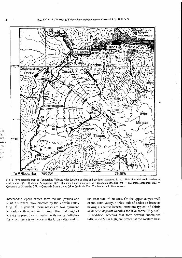
interbedded tephra, which form the old Pondoa and Runtun surfaces, now bisected by the VazcÚn valley (Fig. 3). In general. these rocks are two pyroxene andesites with or without olivine. This first stage of activity apparently culminated with sector collapses for which there is evidence in the Ulba valley and on
the west side of the cone. On the upper canyon wall of the Ulba valley, a thick unit of andesitic breccias having a chaotic internal structure typical of debris avalanche deposits overlies the lava series (Fig. 4A). In addition, breccias that form several anomalous hills, up to 50 m high, are present at the western base
M.L. Hall et aL/Joumal of Volcanology and Geothermal Research 91 (19991 1-21 5
1 Fig. 3. Tungurahua Volcano (5023 m) as seen from the north. The deep Vazcdn valley has conducted lahars and pyroclastic flows directly toward the town of Baños (1800 m) in historic eruptions.
of the cone. They consist of - 60 vol.% of clasts of andesitic lavas (55.8-62.3% SiO,) and subordinate amounts of hydrothermally altered rocks; their ma- trix ( - 40%) is well-indurated, fine-grained ash con- taining abundant lithic and altered fragments. These characteristics (Sieben. 1984) suggest that these de- posits are the remnant mounds of a massive avalanche related to a sector collapse that followed the Tungu- rahua I constructional period.
The magmatic suite of Tungurahua I varies from basic andesites to dacites (Table 1). Thick dacitic biotite-bearing lavas (Runtun dacites: 64.3-66.3% SiO,) and subordinate dacitic block and ash flow
’ deposits covered the avalanche deposits and are now exposed upon the Runtun surface (Fig. 4A). Similar
I_ dacitic lavas, the Minsas dacites, descended from high on the southeast slopes of Tungurahua I, and accumulated against the adjacent metamorphic hills, leaving that flank at a higher elevation than those of the north and south sides. These lavas were eroded in turn by the last important glaciation, thought to be
the bate Glaciation Maximum of Clappertoc (19931, placed in the interval of - 33,000 to - 14.000 years BP. Because the hydrographic network developed more rapidly on the other flanks, the southeast flank has been less eroded and better preserved. On the lower west flank, acid andesites (61.5% SiO,) over- lie the breccia sequence. Together with the Runtun and Minsas dacites, these lavas belong to an impor- tant phase of silicic volcanism that ended the long history of Tungurahua I. Andesites from Tungurahua I have given K/Ar ages of 0.77 Lk 0.05 and 0.35 Lk 0.04 Ma (Barberi et al., 1988).
The structure and inclination of this lava flow series clearly define the form and size of Tungurahua I. The upward projection of the original slopes con- verge to a hypothetical summit whose position and elevation would be similar to that of the present volcano. The downward projection of these same slopes suggests that at the end of Tungurahua I the bottom of the Pastaza valley was at about 2200 m in elevation, some 400 m higher than the present floor.

6
Table I Average compositions and individual analyses (recalculated to 100% LOI free)
M.L. Hall et aL/Joumal of Volcanology and Geothermal Research 91 (1999) 1-21
Tungurahua I Tungurahua II Transition E-III Tungurahua III BA@) AA(8) D(5) BA(1) AA(15) D(1) BA(1) BA(15) AA(26) D(10) ,
sio, Tio2 AI20, Fe20T MnO MgO Ca0 Na,O KlO Pl05
55.75 I .o0
17.56 8.23 0.13 4.26 7.25 3.89 1.65 0.27
100.00
FeO/MgO 1.77 Mg* 50.4
Cr 69 Ni 34 Rb 43.2 Sr 646 La 19.4 Yb 1.80
59.04 0.94
16.75 7.14 0.11 3.55 6.16 3.87 2.18 0.27
100.00
1.87 49.2
82 37 60.6
545 22.3
1.79
64.93 0.62
16.75 4.51 0.10 1.46 3.50 4.75 3.15 0.23
100.00
2.87 38.5
13 6
94.5 440
32.6 2.05
56.60 0.88
16.30 7.90 0.12 5.58 7.16 3.72 1.51 0.23
100.00
1.27 58.0
238 89 35.5
600 15.3 1.22
TG 49
59.71 65.70 0.81 0.57
16.95 16.27 6.60 4.56 0.10 0.09 3.56 1.72 6.12 4.02 4.04 4.33 1.89 2.56 0.21 0.18
100.00 100.00
1.71 51.3
80 32 48.4
620 18.6 I.29
2.38 42.8
25 11 77.0
502 24.5
1.51
TG 48A
56.23 0.90
17.22 7.85 0.12 4.87 6.98 4.09 1.49 0.25
100.00
1.45 55.1
161 60 ??.O
7311 17.0 1.37
56.47 0.89
16.82 7.80 0.12 5.09 7.19 3.88 1.50 0.24
100.00
1.39 56.3
161 .62 35.5
636 16.6 1.39
58.66 0.82
16.71 6.99 0.11 4.27 6.45 3.97 1.78 0.23
100.00
1.49 54.6
117 47 45.8
602 18.4 1.11
64.5 1 0.62
16.05 4.94 0.09 2.49 4.54 4.14 2.45 0.18
100.00
1.82 49.7
66 26 . 70.5
22.6 480
1.42
Numbers with'brackets indicate the number of analyzed samples. BA = basaltic andente; AA = acid andesite; D = dacite. *Total iron as Fe,O,.
Thus, Tungurahua I was a normal andesitic stratovol- cano, with k approximate relief of 2800 m, centered on the same conduit as the present volcano.
4.2. Intermediate cone (Tiingurahria II)
Upon the upper southern flanks, the 80- 100-m- thick Tiacos unit, consisting essentially of andesitic and high-Si andesitic lavas (57.7-60.7% SO,) and having a limited distribution, rests upon the eroded edifice of the older cone and is truncated in turn by the scarp of the sector collapse that occurred about 3000 years BP. Its unique dip and orientation suggest that it was once part of a younger cone (here called Tungurahua II) which had been constructed upon the older cone and which probably attained a similar relief (about 3000 m), given the Tiacos unit's eleva- tion and position.
That Tungurahua II was a large and different cone is also implied by the fact that the deposits of the subsequent voluminous avalanche are composed
mainly of andesitic to high-Si andesitic lavas (57.3- 62.3% SiO,) having chemical characteristics similar to that of the Tiacos series (Table 1 and Fig. 5). Furthermore, they are markedly different than those of the andesitic suite of the basal volcano, which suggests that the latter did not contribute signifi- cantly to the avalanche deposit. Thus, the Tiacos lavas are the only remaining inplace evidence of a large cone whose remnants make up the greater part of the subsequent avalanche deposit. The Tiacos activity is apparently younger than 14,000 years BP, since the Tiacos lavas occupy and post-date two glacial valleys whose terminal moraines have an elevation typical of the Late Glaciation Maximum.
4.3. CoLlapse of the Tungurahua II cone
Given the inferred great relief and steepness of Tungurahua II, the western flank slid readily downs- lope, filling the Chambo river valley with avalanche debris (Fig. 4C). The scars of the collapse amphithe- ater widen downslope to the west. The central part of

M.L. Hall et al./Joumal of Volcanology and Geothermal Research 91 (1999) 1-21 7
b
Avalanche caldera limit
Tun urahua II lava flows
Runtun and Minsas lava flows Tungurahua I breccias (of probable avalanche origin)
, .i : . . Basal series of Tungurahua D (mainly lava flows)
0 Debris avalanche '
(Jematic)
Fig. 5. Sketch diagrams showing the main periods of Tungurahua development up through the 3000-year-old avalanche event.
this avalanche collided with the high ridge immedi- ately in front of the sector collapse. Here, thick deposits of avalanche debris were left, forming a bench upon which the village of Cota16 is presently located. some 400 m above the valley bottom (Fig. 6). The flow was also diverted to the south and the north, along the Chambo and Patate river valleys, respectively. The part of the avalanche that de- scended the southwest flank of the edifice did not encounter major obstacles and consequently flowed southward up the Chambo river valley. Along this path, the avalanche traveled 21 km from the pre- sumed summit, leaving deposits and hummocks read-
small village of Bayushig (Fig. 2) , for example, lies within the hummocky terrain left by the avalanche. Other towns, such as Penipe, occupy terraces and abandoned stream channels that were subsequently cut into the unconsolidated breccias. The avalanche flowed up the Patate river valley for a similar dis- tance (Fig. 4 0 .
The avalanche deposit is a chaotic breccia, locally monolithologic, containing 20-40% matrix of un- consolidated lithic powder, bluish-gray or pink in color. Angular clasts of andesites and high-Si an- desites are the dominant fragments observed in the breccia. No stratification or intemal structure is ob-
ily observed along the Baños-Riobamba road. The served, except for 15-30-m-long pods of jigsaw-

8 M . L Hail et ai./Jounral of Volcanologyand Geothermal Research 91 (1999) 1-21
40 - La (PPm) 0 a
O
n n 8
n %
si02 % I
53 55 57 59 61 63 65 67 50 55 60 65 70 6 MgO%
T a *
2l 1'
o Tungurahua I series (basal volcano).
Tungvrahua II (Tacos Unit)
Tungurahua 111 (post avalanche cone)
SI02 % o : : : : : : : : : : : : : : i
53 55 57 59 61 63 65 67 &.
Fig. 5. K20-Si0, . MgO-SiO, and La-SiO, geochemical diagrams. BA = basic andesites: AA = acid andesites; D = dacites. HK, LK and MK define the areas of high. medium and low-potassium contents.
fractured lava flows, as well as occasional packages of randomly oriented tephra sequences that contain tan to pinkish ash flow deposits with glassy dacitic blocks and/or scoria bombs. The avalanche deposit covers at least 80 km'. Its maximum thickness at the western foot of the volcano is - 400 m. To the north and south, the deposit gradually thins to 30-50-m- thick, but may reach 200 m in places. Its estimated volume is - 8 km3.
A large matrix-rich debris flow, yellowish-tan in color, was generated shortly after the avalanche and its deposits are seen principally in the Chambo val- ley where they fill depressions in the irregular sur- face of the avalanche deposit. Frequently, pods of unconsolidated avalanche breccia are caught up in the lahar deposit, suggesting that the lahar immedi- ately followed the avalanche. This flow was appar- ently the result of the mobilization of water and
íce-saturated parts of the debris avalanche, an origin similar to that of the North Fork Toutle River lahars during the 1980 Mount St. Helen's eruption (Janda et al., 1981). Scoria bombs with cooling fractures are found within the lahar, implying that an eruptive event either triggered or accompanied the collapse.
This lahar deposit overlies the main avalanche breccias on the Cota16 bench (Section, Fig. 6) . Here, it contains non-carbonized logs which have been dated at 2995 k 90 years BP, giving the age of the avalanche event. The lahar deposit is in tum overlain by a second avalanche deposit. This second avalanche must have occurred shortly after the lahar, since only an uneroded and unincised surface of the first avalanche fan would have allowed the second avalanche to cross the now deep Chambo river canyon and deposit itself upon the lahar and earlier avalanche deposits.

~~ ~ ~~~~
M.L. Hall et a l , / Journal of Volcanology and Geothermal Research 91 (1999) 1-21
COTALO CHACAUCO SECTION SECTION
-m years BP
Andesitic pyroclastic
ash, bombs and lithics. Soil or paleosoil ,a\q&q, aa o a flow deposit : blocks,
\ .=. -.. -, -\ Block-rich lahar deposit
I I Ash Fall deposit
Alternating ash and scoria fall deposits deposit /fluviatil deposit
Avalanche deposits
NW SE Km - 5 -1
- - -
. . ~
- - Chambo river - I l I I I I I Km I 1 I l O 2 4 6 8 10 12 14 16
Vertical exageration : 2X
9
Fig. 6 . NW-SE topographic profile of the present cone showing the avalanche deposit and representative stratigraphic sections in the Chambo valley.
The - 3000 years BP avalanche event was fol- lowed by the extrusion of large dacitic lava flows. South of Las Juntas, the avalanche breccia is over- lain by vitrophyric dacite lavas bearing olivine, two pyroxenes and minor amphibole (the Cusua dacites, Fig. 4C; 64.0% SO2) . These 6-km-long flows were probably related to dome extrusion in the amphithe- ater. A large debris flow, containing prismatically jointed glassy blocks of the same dacite, up to 10 m in size, was generated during this activity (see Fig. SC). Following this dacitic activity, there is no evi-
dence of eruptive activity until - 2300 years BP, implying that the volcano was quiet for approxi- mately 700 years.
4.4. Present cone (Tungurahua III)
The past 2300 years have seen the growth of Tungurahua III, characterized by almost continuous eruptive activity and the repeated generation of lava flows, pyroclastic flows, and debris flows. These have principally descended the cone’s western and

10 h4.L. Hall et al. /Journal of Volcanology and Geothermal Research 91 (1999) 1-17]
_.I
. .. -. ! :'
tun and Ulba valley:
Juive Chico Pre-historic lava flows Undifferentiated Pre-historic lava flows
Alluvium and lahar deposits plder limit L T l Avalanche deposits
I - - - - - - Pre-avalanche volcanic8
. Runtun and Minsas dacites Tungurahua II lava flows
w d Breccias Mainly lava flows
Fig. 7. Simplified geological map of Tungurahua Volcano.

I l h4.L Hall et al./Journal of Volcanology and Geothermal Research 91 119991 1-21
northem flanks down to the Chambo and Pastua rivers (Fig. 7). The eruptions also ejected moderate
amounts of ash, scoria lapilli and occasionally pumice lapilli, which were transported by winds chiefly to
FALLOUT DEPOSITS MOTILONES - U PIRAMIDE
I PYROCLASTIC SEQUENCE PYROCLASTIC SEOUENCE LAS JUNTAS - IA REA
CONFESIONARIO 1 I
2 9 W - 9 0 y. BP
Andesitic pyroclastic flow & ~ $ i b c k s , ash, bombs
Pyroclastic flow deposit with heterogeneous (banded)
soil or paleosoit
Lavaflow
Block-rich lahar deposit pumice blocks . . .
Ash-rich lahar Andesitic bomb-rich scoria deposit / fluviatil deposit flow deposit
‘ESIONARIO Ml of A
P2
RIO CHAMBO
Gray ash induding lapilli
Black ash Smria lapllli Black ash
Alternatrj layera d ash and m ’ a lapilli
P1 Pumice lapilli faif layer Ash and pumice
Alternating ash and scoria lapilli Gray ash and scoria lapilli Scoria lapilli and bombs Ash Ash, scoria lapilli and pumice lapilli Ash
Scoria lapilli (andesitic)
Altemating ash arid scoria
Avalanche deposit
0 Ashfall deposit
Andesitic scotia fall deposit
Pumice fall deposit
Alternating ash and scotia fall deposits
Fig. 8. Stratigraphic columns related to Tungurahua III cone. See Fig. 2 for location. Note: P1 unit marks transition from basic andesitic volcanism to mixed andesitic and dacitic volcanism. Because no soil nor hiatus is observed at this horizon, this transition was apparently rapid. Note changes in scale between columns.
A

12 M.L. Hall et al./Joumal of Volcanology and Geothermal Research 91 (1999) 1-21
the west and southwest. The Tungurahua III cone developed during two main periods (Fig. 10).
4.4. I. Tiingiirahua III-1 The first period (approximately 2300- 1400 years
BP) is composed of three volcanic units that, al- though discussed separately, represent a continuum of activity whose products were deposited upon dif- ferent sectors of the western flank at different mo- ments. Selected stratigraphic columns showing these deposits are presented in Fig. 8.
(1) Near Las Juntas, a series of olivine and two pyroxene basic andesite lavas (56.0-56.3% SiO,) mark the volcano’s reactivation. Most flows traveled down the west side of the new cone and then flowed 5 km northward down the Chambo valley. Interbed- ded in these lavas is a scoria-rich pyroclastic flow deposit of the same composition, which contains carbonized wood that has given a radiocarbon date of 2215 k 90 years BP. The late lavas of this se- quence are characterized by augite and large olivine phenocrysts (5-10 mm) and the absence of hypers- thene. The total thickness of this basal unit is 140 m (see Cusua section, Fig. 8). Southwestward, in the Confesionario and La Rea valleys, similar olivine and clinopyroxene-phyric andesites occur, resting upon the avalanche debris. On the basis of petrologi- cal similarities, the lava flow which descended the Ulba valley is related to this unit.
( 2 ) Following the basal lava series, explosive activity occurred, which led to the mantling of the new cone by thick sequences of scoria flow deposits and subordinate ash and scoria fall layers. Between the Pingullo and Confesionario channels, for exam- ple, these deposits are estimated to be > 100 m thick. They give the western side of Tungurahua III its smooth topography observed between the 2400- and 7900-m contours. On the lower slopes, the avalanche I hummocks are almost entirely covered by these deposits (as an example, see Chontapamba,
- . .
Fig. 7). Stream incisions expose sections up to 30 m thick, two of which are presented in Fig. 8 (Moti- Iones and Confesionario sections).
Pyroclastic flow and surge deposits, interbedded with thin andesitic zsh and lapilli fall layers, typi- cally contain decimeter-sized bread-crust bombs and black vitric blocks in a brown or reddish-brown ashy matrix. The juvenile clasts are invariably two pyrox- ene basic andesites and andesites (56.3-58.2% SiO,). At one site (48, Confesionario valley) the basal part of the sequence shows evidence of a heterogeneous magma: juvenile andesite blocks and bombs (sample TG 48A, Table 1) contain light-gray dacitic bands and inclusions bearing amphibole (sample TG 49). These dacitic bands apparently correspond to a slightly more differentiated magma leftover from the Cusua dacitic magmatism.
In these pyroclastic flow sequences, the presence of surge deposits, numerous inclusions within the bombs, and L?rge numbers of quenched clasts sug- gest powerful open-conduit explosions and magma- water interactions. The nature and shape of accessory blocks attest to the destruction of andesitic domes or lava plugs obstructing the conduit. These deposits possibly formed by collapse of the denser parts of the eruptive column, such as were observed during the brief, vertically-directed explosions generated in the 1979 St. Vincent activity (Shepherd and Sigurds- son, 1982).
During this period, block and ash flows derived from collapsing lava fronts were also produced and directed to the northwest. Their deposits are ob- served at La Piramide (Fig. 7 and section, Fig. 8) and in the middle of the Las Juntas section (layer A, Figs. 8 and 9a), where they predate a sequence of ash and lapilli fall layers and scoria flow deposits dated.at - 1200 years BP. In these deposits, juvenile vitric blocks have similar compositions (56-57% SiO, ) to those encountered in the scoria flow units, showing that no significant chemical evolution oc- curred during this phase.
Fig. 9. Pyroclastic deposits of Tungurahua III. (a) Las Juntas section (site 1; description of layers A-G in Fig. 8 and text): (b) bomb-rich scoria flow deposit in La Rea valley. equivalent to layer F at site I; (c) Lahar deposit in Patate valley, bearing large bombs of the Cusua dacite: (d) 1916 ash and scoria flow deposits (8-m thick) in Vazcún valley; (e) banded (andesitic and dacitic) blocks in the 1886 ash and scoria flow deposits, southeast of Las Juntas.

M.L. Hull rt al. / Jcmrtinl of Volcunologv utid Georhennul Research 91 (1999) I -21 13

I I M.L. Hull et al./Joitrnal of Volcanology and Geothermal Research 91 (I9991 1-21
( 3 ) A renewed phase of effusive activity followed, during which three flows of two pyroxene andesite lavas (57-58% SiO,), whose total volume is esti- mated at - 5 7 0 x IO6 m3, descended the northern and northwestern flanks. The main flow descended the old Pondoa surface to Juive Chico, filled the Pastaza canyon. and then flowed downvalley at least 30 km. Several towns, including Baños, sit directly upon this flow (Fig. 7). The second flow series descended the northwest flank following the Juive Grande drainage and a third flow traveled down Vazcún valley. At Pondoa, these lavas predate an ash fall layer in which charcoal gives an age of 1470 f 85 years BP. Their youthfulness is also indicated by the well-preserved lava flow terraces, pools, and chan- nels observed to the east of Baños.
As the dominant winds of the region blow from east to west, most tephra fell upon the western slopes of the new cone. Generally the tephra were not carried far: at sites 15 km downwind, the ash fall layers rarely exceed LO cm. The fallout tephra of the first main period consist entirely of andesite and basic andesite products; no siliceous layers have been observed. On the contrary, significant fallout deposits of the second main period are silicic. This change is placed at a prominent pumice lapilli fall of dacitic composition (layer P1, Figs. 8 and 10) that has a wide distribution and is about 1200 years old.
4.4.2. Twiguriilzun Ill-2 The second main period of the present cone began - 1700 years BP and is still continuing. The upper
parts of the Las Juntas section (Figs. 8 and 9a) provide a good record of the pyroclastic activity \\hich preceded historic times. They consist of a series of pyroclastic flow deposits. fallout tephra and lahars. which begins with the Pl pumice lapilli fall (62.7% SiO-) and scoria flow units (layers C-D) containing banded scoria bombs (61-64% SiO,). Upsection. it continues with homogenous andesitic ( 5 7 . 5 - 5 8 . 5 9 SiO,) block and ash pyroclastic flows (layers E. F). and'finally ends with alternating beds of andesitic scoria lapilli and ash and banded dacitic pumice lapilli (layer GI. Correlations with the La Ren and Guishnaute sequences are shown in Fig. 8. Layer F is readily recognized in most places, due to the presence of large (< 1 m> breadcrust vitric bombs.
Two radiocarbon dates on charcoal from the sco- ria flow deposit IC-D were obtained from Krueger Enterprises (Cambridge, MA) and the Centre for Isotope Research (Groningen. the Netherlands): the measured ages are 1210 f 200 and 1230 f 30 years BP. A third date of 955 f 80 years BP was obtained from charcoal in the bomb-rich layer at the Guish- naute section which is correlated with the F layer of the Las Juntas section and the lower layer of the La Rea section (Figs. 8 and 9b).
The eruptive style that dominated the 1200-900 years BP period returned during historic times after an apparent repose of - 500 years. The historic records report four eruptive periods. However, the postulated 1641 AD eruption lacks both reliable eyewitness descriptions (Egred, 1989) and strati- graphic confirmation. Thus, only three important historic eruptive periods are recognized here, each of which comprises one or more explosive episoues that mainly gefierated pyroclastic products of both an- desitic and dacitic composition and that were fol- lowed in turn by the emission of andesite lava.
In 1773 AD, following an andesitic ash fall and a widespread dacitic pumice lapilli fall CP2 layer. 65.5% SO,; Figs. 8 and LO), a large andesitic lava flow, bearing augite, rare olivine and hypersthene and with an estimated volume of 102 X lo6 m3, flowed down the cone's north-northwest flank to Juive Grande and the Las Juntas area and dammed the Pastaza river for several days.
The 1886 eruption witnessed numerous pyroclas- tic flows that descended different routes on the west- ern flank (Martinez. 1886). being more frequent on the northwest side, where they partially buried the 1773 lava tlow. Similar to those of pre-historic eruptions, the 1886 pyroclastic flows (basically ash and scoria flows) contain well-banded bombs whose composition ranges from acid andesites to dacites (6 1-64.5% SiO,; Fig. 9e). Plagioclase, augite, hy- persthene, olivine and a trace of amphibole comprise the typical mineralogy of the acid andesites. A few months later, a lava flowed down the northwest flank towards Cusua and dammed the Chambo river; its volume is estimated at 89 X IO6 m3. This lava has the same composition (61.3% SiO,) as the less silicic bombs of the preceding pyroclastic flows, but is more siliceous than the lava left in the crater by the 1916-1918 activity.

M.L. Hall et al./Joumal of Volcaiiology and Geothemial Research 91 (19991 1-21
Magma Sequence name / deposits Eruptive stages, major composition eruptions and datings
Mainly pyroclastic ~ I activity
Andesitic 191 6-1 91 8 eruption - Dacitic --> acid andesite -->andesitic 1886 eruption
Dacitic --> 1773 eruption acid andesite - P2
4-- Unknown activity 4-
Dacitic La Rea and Las Juntas upper pyroclastic flows
Basic andesite & andesitic
Bombrich pyroclastic flows in La Rea and upper Las Juntas sections (layer F)
dacitic --> acid andesite
Las Juntas pyroclastic flow sequence (middle part of the section) - + PI -
890+/-135 BP (ash dep 955 +/- 80 y. BP
1230 +/- 30 y. BP
-4; 1470 +/- 25 y. BP in an ashfall deposit
Andesitic Juive Chico and Vazcun Lava flows ] lconstructlon stage I - La Piramide and Motilones pyr. flows, lower, mainly andesitic, fallout deposits
Basic andesite , lower Las Juntas pyr0ClaStiC flows, 8 andesitic
I - Lower Las Juntas series + Rio Charnbo (mainly lava flows)
1 I Construction stage I Basic andesite 4-221 5 +/- 90 v. Bp L Dacitic Cusua dacites
-I
Main avalanche event -2955+/-90 y. BP
Mainly acid Tungurahua II andesite
Basic andesite to Tungurahua I Age : up to - 0.7 Ma
Fig. IO. Generalized stratigraphy of Tungurahua volcano with special emphasis to the post avalanche Tungurahua cone.
Finally, the 1916-1918 eruptive episode was most noteworthy for the numerous pyroclastic flows which descended the northwest and north flanks to’the Las Juntas area and VazcÚn valley (Fig. 9d); many were witnessed and photographed (Martinez, 1932). The composition of these products was mainly andesitic (56.8--57.7% SiO,). During this episode, lava was also confined to the crater.
Lahars were produced during the 1773, 1886 and 19 16- 19 18 eruptions. Baños narrowly escaped disas- ter in 1773, when a large debris flow in the VazcÚn valley barely spilled over into the city. In 1886, the largest lahars descended the SW flank to Puela. Others traveled down the Vazcún and Ulba valleys, which again saw large lahars during the 1916 erup- tion.
A

16 M.L. Hall el al./ Joitrnal of Volcanology and Geothermal Research 91 (1999) 1-21
5. Discussion and conclusion
5.1. Etuplace,nent of the 3000-!ear-old acalanche
The characteristics of the 3000 years BP debris avalanche are worthy of further discussion, given its youthfulness. good preservation, and notable size. Factors that played a dominant role in the distribu- tion of the deposits include: its large volume (esti- mate 8 km3), the great relief (estimate 3000 m> and steep slopes (25-35") of the cone, and the intrusion of dacitic magma into the cone which apparently led to its instability, a situation similar to that of the 1980 Mount St. Helens event (Voight et al., 1981).
In order to better document the nature of the collapse, the event was modeled as follows. The western flank of the cone was divided into three sectors. to take into account the differences in the presumed topographic relief. The northwest flank is thought to have had - 3000 m of relief, the west flank, some 2800 m of relief, and the southwest side about 2600 m of relief. Fig. 11 shows that an avalanche with H / L = 0.1 1 best fits the overall distribution a id reach of the 3000-year old deposits in the Patate and Chambo valleys. Based upon this theoretically possible distribution and our field ob- servations. we surmise the following scenario.
The main axis of the collapse was to the north- west. There, the high ridge of La Piramide helped to split the avalanche into two parts. The part which traveled south of this ridge collided directly with the canyon wall near Cotaló. in agreement with the thickest avalanche deposits 400 m) observed in the Chambo valley. Part of this flow surmounted the canyon wall and was diverted to the north-northeast by the lower slopes of Cerro Huisla toward the Patate valley (arrow 1. Fig. 11). There, deposits up to 50 m thick are still preserved as far as 15 km up the valley. Additionally, a part of the avalanche trateled north of La Piramide ridge and was fun- neled up the axis of the Patate valley (arrow 2). Southwestwards. the avalanche tlowed up the Chambo river valley about 15 km, taking advantage of its flat gradient.
An unusual characteristic of the Tungurahua avalanche event is its widely open (- 1 IO") am- phitheater. Considering the orientation of collapse amphitheaters to tectonics, sector collapses in the
Andes tend to occur perpendicularly to regional faults (Francis and Wells, 1988). This is the case at Tungu- rahua, where the main tectonic lineaments are ori- ented "E-SSW and NNW-SSE. The southern limit of the avalanche amphitheater is bounded by a northeast-trending fault, while its northwest-oriented northern limit is aligned with a possible fault in the Patate valley. Among the Andean volcanoes, only the collapse of the Old Cone of San Pedro Volcano. cut by an "W-SSE striking normal fault. seems to have generated such a wide depression. Thus, al- though the deformation related to the intrusion of a viscous cryptodome probably triggered the avalanche, as suggested by the post-collapse extrusion of dacite lavas, the local tectonic pattern apparently played an important role in orienting the collapse event. At least it was a key factor in controlling the width and shape of the avalanche amphitheater.
5.2. Variablp eriiptiile behaoior of the Tiingurahiia III actirity
The activity of Tungurahua I I ï Sas had variable eruptive styles and corresponding products. The available information about historic eruptions, as well as that obtained from field work, suggests that this activity has had a cyclic pattern, alternating between explosive and effusive episodes, during both the first and second periods.
During the first period of Tungurahua III, from 2300 to 1400 years BP, the two major effusive episodes (the Las Juntas lava sequence and later the Juive Chico lava outpouring) were separated by large pyroclastic episodes (e.g., the Motilones and La Pi- ramide scoria flow sequences). Despite this variation in behavior, no significant petrological evolution is noted: that is. the eruptive products have varied little in composition (SiO? 55-58%) during about 1000 years. This, in turn, suggests that magma was proba- bly supplied almost continuously from a deep source and consequently little differentiation occurred in whatever shallow magma chambers might have ex- isted. Variable magma/water ratios, as suggested by the phreatomagmatic character of the Tungurahua III- 1 pyroclastic deposits, would best explain this variation in eruptive style. For example, until the pyroclastic episode of Tungurahua III- 1, the volcano probably had a lower elevation and a limited icecap, resulting in a less phreatomagmatic and a more
*
I l

M.L. Hall et al. /Journal of Volcanology and Georhemlal Research 91 (1999) 1-21
I)
c
17
Fig. I I . HaLard map for lava flows. fallout deposits and sector collapse events. I = Distribution of a hypothetical debris avalanche with an - H / L = 0.09: 2 =distribution of a hypothetical debris avalanche with an H / L = 0.1 1. very similar to the 3000 years BP avalanche: 3 = ilihtrihutiun'of a hypothetical debris avalanche with an H / L = 0.18 h a l l volume avalanche): 4 = caldera limits which would control the distribution of small- to medium-size avalanches in futuie events: 5 = most probable paths of future lava flows. Expected ash fall ilimibutionb: '4 < 10 um: B < 5 cm.
effusive behavior. As the volcano attained a greater height during Tungurahua 111-2 and supported a larger
icecap, phreatomagmatic activity became progres- sively more important.
A

18 M.L. H d et al. / Joiininl of Volcanology und Geothermal Research 91 (1999) 1-21
Beginning about 1300 years BP, the activity of Tungurahua 111-2 has been characterized by repeti- tive pyroclastic episodes (tephra falls and pyroclastic flows) followed by lava flows or crater plugs. Pyro- clastic activity dominates the main part of each eruptive episode, thanks to the role played by both juvenile and meteoric water. However, as the vol- cano heats up and dries out, less meteoric water is available and more effusive activity ensues. This leads to lava flows. dome extrusion. and block and ash flows. This cyclic process is similar to that observed in many andesite volcanoes, (e.g.. Fuego de Colima in Mexico; Robin et al., 1991). Parallel to the eruptive evolution, a petrologic evolution is noted in the course of these eruptive cycles. From mainly acid andesite to dacitic at the beginning of the eruptive cycles, the magma turns andesitic with the lavas emitted at the end of the eruptions.
These eruptive events occur approximately every 100 years, which roughly agrees with the number of eruptive sequences observed for the past - 1300 years as well as with the eruption frequency of the past 300 ye_ars.
5.3. Growth rate of the presetit cone
., I The good chronological control as well as the -*y . well constrai,ned topographic changes permit an esti-
mate of the magma flux at Tungurahua. During the growth of Tungurahua III. the point of emission has not varied,.xhich has had the effect of directing the greater volume of its volcanic products into con- .strutting .the new cone within the amphitheater.
Earlier, we estimated the volume of the avalanche deposits at - 8 kmJ. This corresponds to an nvalanche depression of - 6 km3, taking into con- sideration the expansion effect noted by Voight et al. I98 1 ) for the Mount St. Helens avalanche deposit.
Given the height of the amphitheater scars (30-160 m high) and the present slopes of - 30". we calcu- late that - 3.1 km3 of material is still needed to rebuild the cone to its previous height. Thus, the approximate volume of the present cone is 2.9 km3. Considering that the cone is roughly composed of 70% pyroclastic deposits (mean density 1.6) and 30% lava flows (density -2.65), such a volume represents - 2 kmJ DRE. To this volume, we add the 0.57 km3 of lava that flowed out of the caldera
.e,- r
, *
(Juive Chico series) and the estimated 0.85 km3 (DRE) of tephra that fell downwind of the volcano, the latter being based upon a 20 X 40 km elliptic distribution pattern with a maximum combined ash fall thickness of 8 m at the cone. Thus, we estimate that the magma flux (DRE) has been about 3.45 km3 during 2300 years, corresponding to a magma supply rate of about 1.5 X lo6 mJ/year.
This rate is similar to the rates given by K. Nakamura (1964) and M. Nakamura (1967) for the last 1500 years at Oshima Volcano and for the period 4000- 1000 years BP at Kaimon-dake Vol- cano (1.67 X lo6 m3/year and 1.17 X lo6 m3/year, respectively). Our estimate also fits in the range of construction rates for andesitic volcanoes: from 0.63 X lo6 m3/year (Hakone Volcano) to 2.7 X IO6 m3/year (Sakurajima Volcano), although the contri- bution of dispersed tephra was not considered in those calculations (Nakamura, 1976; Wadge. L 982). The presen: value is also similar to the cumulative volume of lavas produced at Merapi Volcano during the last century (1.2 X IO6 M3/year, Siswowidjoyo et al., 1995). Conversely our estimate at Tungurahua for the last 2300 years is 2-3 times the estimated rate of eruptive volume in the Central Andes for the Late Cenozoic (Baker and Francis, 1978: Crisp. 1984). The intermittent character of andesitic mag- matism is well known elsewhere: this implies that Tungurahua's activity has been intense during the past 2300 years.
5.1. Volcariic hazard assessinetit
5.4.1. Ha:ards due to sector collapses arid related lahars
Although a sector collapse and associated debris avalanche are rare events. at Tungurahua they have occurred at least twice in the geologic past and the most recent event happened only 3000 years ago. Collapse events repeated at relatively short time intervals are reported for several andesitic edifices, (e.g.. Augustine Volcano in Alaska, Siebert et al., 1995).
In Fig. I l , three sizes of avalanches are consid- ered: ( I ) an avalanche with H / L = O. 1 I , characteris- tic of large volume avalanches (Siebert et al., 1987); (2) a worst case event (greater runout and a H / L = 0.09); and (3) an avalanche with H / L = 0.18, a

M. L. Hd1 et d./ Journal oj' Volcanology and Georliermal Research 91 (1 999) 1-2 I I9
value typical of small avalanches (< 1 km3). Due to the rapid supply of magma during the last 2300 years, Tungurahua Volcano 'has already refilled about half of the avalanche depression. Thus, it is believed that the conditions of the present cone (3000 m relief and 30" slopes) will favor a future collapse. If it were to happen today, an avalanche of 1-3 km' in volume could be generated and would have a distribution similar to that shown in case 3.
Lahars associated with collapse events generally form by the remobilization of water-saturated parts of the avalanche deposits, or by the incorporation of water and snow (Gorshkov, 1959; Janda et al., 1981). .),
Furthermore, lahars may occur during or after erup- tions when lakes dammed by avalanche debris break out catastrophically, or when a large volume of water is displaced violently (Glicken et al., 1983; Meyer et al., 1986; Siebert et al., 1987).
Following the 3000-year old avalanche event, a 14km long section of the Chambo river valley was blocked by the avalanche debris and associated lahar deposits, forming a large natural dam and a 10- km-long lake (Fig. W. This temporary lake. whose volume is ,estimated at 0.4 km', left a - 19-m-thick sequence of finely-bedded lacustrine sediments. mainly gray sands and silts, that are found up to the
Kilometers 0 1 2 3
m -
78" 30 78 !5 78'
-
D Fig. 12. Hazard map for pyroclastic flows and lahars, showing the main runouts followed by historic tlows (PF = pyroclastic flows). I = High harard for directed blasts and fallback pyroclastic tlows over the whole area, and lahars in the valleys: 2 = minor hazard area for pyroclastic flows: 3 = high hazard for lahars in the lower Pastaza valley.

20 M.L. Htrll et al. /Joirnial of vokrinology und Geotliemial Research 91 (14991 1-11
3410-m contour line in the Puela and Chambo river valleys. As the rising lake in the Chambo valley topped and breached the natural dam. the resulting flood generated an enormous debris flow that left thick. localized deposits containing avalanche brec- cia pods and andesitic clasts in a gray sandy matrix, derived from the reservoir sediments. At Las Juntas, the avalanche deposits are buried by this debris flow unit which in turn is covered by the dacite-block lahar associated with the Cusua dacitic lava extru- sion. This clearly indicates that the lake-breakout debris flow is one of the events of the avalanche cycle. At the confluence of the Pastaza and Topo rivers, 30 km downstream from Baños, a similar deposit, up to 120 m thick, is observed. Its thickness emphasizes the catastrophic nature of this laharic event.
Following an avalanche event. lahars certainly represent the greatest hazard and this hazard remains high long after the eruption has ended, especially when large drainages are blocked and lakes are formed. Some of the largest lahars probably resulted from lake breakouts (Siebert et al., 1987). Tungu- rahua's setting invites such a possibility: even if the next collapse is of small volume (< I km3). the resulting debris avalanche would likely refill the narrow Chambo valley. damming it, which would probably generate another lake-breakout debris flow of significant proportions.
-.*
5.4.2. H~i:ards dire to lniw ,jhrs, pyroclastic jlorvs í i t i d cissociíited debris jlortx
Due to the relatively high viscosity of the mag- mas. lava tlous do not attain great velocities and thus do not represent a major hazard for populations IiLing at the foot of the volcano (Fig. I I ) .
From the .study of historic and prehistoric activity i t is clear that pqroclastic flows and lahars triggered by pyroclastic tlow/surge activity represent the prin- cipal hazards. Based upon the eruption frequency of the last 7 millenniums, future eruptions are to be expected and consequently, the emission of pyroclas- tic tlows and lahars such as occurred in 1886 and 1916-1918 are likely. In this case, Baños and sev- eral villages located on the western and northern tlanks would be directly threatened. Fig. 12 empha- sizes the pyroclastic flow and debris flow hazards in the valleys which head on the volcano, especially the
Vazcún and Ulba valleys, which descend toward Baños and the Agoyan dam.
Acknowledgements
This study is part of a cooperative program in volcanology camed out by the Geophysical Institute of the National Polytechnical School of Quito and IRD (French Scientific Research Institute for the Development in Cooperation, ex-ORSTOM). Five
C datings were done by Krueger Enterprises (Cam- bridge. MA) and one additional dating by Dr. J. van der Plicht at the Centre for Isotope Research, Univer- sity of Groningen (the Netherlands). Thanks are also due to JO Cotten (Université de Bretagne Occiden- tale, Brest, France) for providing the whole-rock analyses. The final version of the paper was greatly improved 5y the careful reviews by S. De Silva and an anonyrmus reviewer.
I4
References
.4imeida. E.. Ramon. P.. 1991. Las erupciones hi\taricas del volcan Tungurahua. Bol. Geol. Ecuat. 2 (I ). 89- 138.
Baker. M.C.W., Francis, P.W.. 1978. Upper Cenozoic vdcnnism in the Central Andes-Ages and volumes. E m h Planet. Sci. Lett. 41, 175-187.
Barberi. F.. Coltelli. M.. Ferrara. G., 1988. Plio-Quaternary vol- canism in Ecuador. Geol. Mag. I15 ( l ). l - 14.
Clapperton. C M . 1993. Quaternary Geology and Geomorphology of South America. Elsevier, Amsterdam. 779 pp.
Crisp. I.A.. 1981. Rates of magma emplacement and volcanic output. J. Volcanol. Geotherm. Res. 70. 177-2 I 1.
Egred. I.. 1989. Informe sobre la investigacion historica referente a las erupciones de los volcanes Tungurahua y Cotopaxi. In: Proyecto hidroelectrico San Francisco: informe Final de vul- canologia. Unpublished report. Republica del Ecuador. Minis- terio de Energia y Minas, %pt. 1989. 123 pp.
Francis. P.W.. Wells. G.L.. 1988. Landsat thematic mapper obser- vations of debris avalanche deposits in the Central Andes. Bull. Volcanol. 50. 258-278.
Glicken. H.. Meyer. W.. Carpenter. P.J.. Sabol. MA.. Swift, C.F.. Kresh. D.L.. 1983. Actual and potential lake breakouts at Mount St. Helens. Washington. Eos, Trans. Am. Geophys. Union 64, 894. abstract.
Gorshkov. G.S.. 1959. Gigantic eruption of the Volcano Bezymi- amy. Bull. Volcanol. 70. 77- 109. .
Hall. M.L.. Hillebrandt. C.G.. 1988. Mapa de los peligros volcani- cos potenciales asociados con el volcan Cotopaxi. I /50.000 scale map. in two parts (north and south). Republic of Ecuador.

M.L. Hull et d. / Jolinial of Volcnriology arid Georlienrial Research 91 ( 1999). 1-21 I I
Instituto Geofisico de la Escuela Politecnica Nacional (Ed.). UNDRO-US AID-EPN Project.
Hall. M.L.. Vera. R.. 1985. La actividad volcanica del volcan Tungurahua: sus peligros y SUS riesgos volcanicos. Rev. Po- litec.. Quito IO. 91-144.
[NECEL (Instituto Ecuatoriano de Electritlcacion). 1989. Proyecto hidroelectrico San Francisco: informe Final de vulcanologia. Unpublished report. Republica del Ecuador. Ministerio de Energia y Minas. S>pt. 1989. I23 pp.
Janda. R.J.. Scott. K.hI.. Nolan. K.M.. Martison, H.M.. 1981. Lahar movement. effects. and deposits. In: Lipman. P.W.. Mullineaux. R. (Eds.). The 1980 Eruptions of Mount St. Helens, Washington. Geological Survey Prof. Papers 1250. pp.
Litherland. M.. Egiiez. A.. 1993. &Mapa geológico de la República dei Ecuador. I / I .OOO.OOO. British Geological Survey
Quito. Meyer. W.. Sabol. M.A., Glicken. H.. Voight. B.. 1986. The
effects of ground water. slope stability and seismic hazards on the stability of the South Fork Creek blockage in the ,Mount St. Helens area. Washington. US Geol. Survey Prof. Paper 13-15,
Martinez, A.. 1886. Report in the La Nacion newspaper. 17 March 1886. Guayaquil.
Martinez. N.. 1932. Las grandes erupciones del Tungurahua de los años 19 16- 1918. Publicaciones del Observatorio Astronomico de Quito. Seccion de Geofisica. Quito (Ecuador).
Nakamura. K.. 1964. Volcano-stratigraphic atudy of Oshima vol- cano. Izu. Bull. Eanhquake Res. Inst. Tokyo Univ. 42. 649- 778.
Nakamura. K.. 1976. Preliminary estimate of global volcanic production rate. [n: Colp. J.L. (Ed.). The Utilization of Vol- cano Energy. Sandia Laboratories. .Albuquerque. pp. 273-285.
Nakamura. M.. 1967.. On the volcanic products and history of Kaimon-dake volcano. Bull. Volcanol. Soc. Jpn. 12. 119-13 I .
R e i s W.. 1874. Eber lavastriime der Tungurahua und Cotopaxi. Zeitschr. Dt. Geol. Ces. 26. 907-927.
46 1-486. &,
?, (Keyworth, Nottingham) y CODIGEM (Quito. Ecuador).
Reiss. W.. Stiibel. A,. 1904. Das Hochgebirge der Republik Ecuador. Petrographische Untersuchungen. Berlin. 236 pp.
Robin, C.. Camus. G.. Gourgaud. A.. 1991. Eruptive and mag- matic cycles at Fuego de Colima volcano. J. Volcanol. Geotherm. Res. 45, 709-225.
Salazar. E.. 1977. La geologia del tlanco septentrional del volcan Tungurahua. Tesis de grado. Escuela Politecnica Nacional. Quito. 98 pp.
Shepherd. J.B.. Sigurdsson. H.. 1982. Mechanism of the IY79 explosive eruption of Soufriere volcano. J. Volcanol. Geotherm. Res. 13. 119-130.
Siebert. L.. 1981. Large debris aLalanches: characteristics [if
source areas. deposits and associated eruptions. J. Volcanol. Geotherm. Res. 22. 163-197.
Siebert, L.. Glicken. H., U¡. T.. 1987. Volcanic harards from Bezymianny- and Bandai-type eruptions. Bull. Volcanol. 49. 435-459.
Siebert. L.. Beget. J.E.. Clicken. H.. 1995. The 1883 and Iate-pre- historic eruptions of Augustine Volcano. Alaska. J. Volcunol. Geotherm. Res. 66. 367-395.
Simkin. T.. Siebert. L.. 1994. Volcanoes of the World. 2nd edn. Smithsonian Institution. p. 142.
Siswowidjoyo. S.. Suryo. I.. Yokoyama. I.. 1715. Magma eruption rates of ,Merapi volcano. Central Java. Indonesia during one century ( 1890- 1992). Bull. Volcanol. 50. I I I - I 16.
Stiibel. A.. 1886. Skizzen ails Ecuador. Aaher edn.. Berlin. 176 PP.
Voight. B.. Glicken. H.. Janda. R.J.. Douglass. P.M..:.1981. Catas- trophic rockslide. avalanche of May IS. in: Lipman. P.W.. Mullineaux. R. (Eds.) The 1980 Eruptions of Mount St. He- lens. Washington. Geological Survey Prof. Papers 1250. pp. 347-378.
Wndge. G.. 1982. Steady >tate volcanism: evidence from eruption histories of polygenic volcanoes. J. Geophys. Res. B 87 (5). 4035-4049.
Wolf. T.. 1892. Geografia y geologia del Ecuador. Brockaus edn. Leipzig, 671 pp.

.t .