Embed Size (px)
Citation preview

1
Auxiliary sciences in archaeology, preservation of relicts and environmental engineering.
CD -no 16, Ed. M Pawlikowski -------------------------------------------------------------------------------------------------
WYNIKI MINERALOGICZNYCH I GEOCHEMICZNYCH BADAŃ EWAPORATÓW ZE ZŁOŻA TAUDENNI-AGORGOTT
(MALI, SAHARA ZACHODNIA)
Results of mineralogical and geochemical investigation of evaporates from the Taoudenni-Agorgott deposit (Mali, Western Sahara).
Jakub PAJĄK, Maciej PAWLIKOWSKI
Pająk J., Pawlikowski M., (2013) - Results of mineralogical and geochemical investigation of
evaporates from the Taoudenni-Agorgott deposit (Mali, Western Sahara).Geol. Quart. ( ):
. Warszawa
Field as well as mineralogical and geochemical investigation of evaporates of Taoudenni-Agorgott deposit were performed. It was stated out that the profile is composed of halite, glauberite, gypsum, carbonates, quartz and clay minerals. The sequence of the presence of minerals at the profile suggests the deposit is the result of evaporation of salty lake during drying of climate at the Sahara Desert. Mineral composition of evaporates suggest that Na-Cl reach like evolved to Na-Ca-SO4 phase and next was fully evaporated and coated with detrital sediments. Jakub Pająk - Department of General Geology, Environmental Protection and Geotourism, Faculty of Geology, Geophysics and Environmental Protection, AGH University of Science and Technology, al. Mickiewicza 30, 30-059 Kraków, Poland; e-mail: [email protected]. Maciej Pawlikowski - Department of Mineralogy, Petrography and Geochemistry, Faculty of Geology, Geophysics and Environmental Protection, AGH University of Science and Technology: , al. Mickiewicza 30, 30-059 Kraków, Poland e-mail: [email protected] Key words: Sahara Desert, evaporates, mineralogy, Taoudenni, Mali, halite
Introduction
The Taoudenni-Agorgott salt deposit was visited during the field trip to the Malian
desert in the year 2008. The salt deposits were studied in-situ and evaporates samples were
collected in one of the existing open pit mine in that area. The aim of this paper is to review

2
previous works concerning studied area and to compare results of field and laboratory
investigation with the earlier data.
Geographical settings
The Taoudenni-Agorgott salt deposit is located in the northern part of the Mali
Republic, around 600 km deep into the Sahara Desert interior (fig. 1). Geographic coordinates
of present-day working excavations called New
Agorgott are 22o36’N and 4o02’W. The local depression of Taoudenni (circa 130 m
AMSL) is the lowest area of the West Africa within more than thousand kilometers. Salt
mines are situated at almost plane surface of ancient lake covered with muddy-gypsum crust.
From the south, Taoudenni-Agorgott depression is bounded by the rocky scarp with Djebel
Fum el-Alous culmination. Djebel al-Gara (283 m AMSL) and Djebel al-Kudi mountains
tower above the central part of the ancient lake, and in the north, Djebel Hammou-Salah
mountain ascendant to 315 m AMSL. Depression zone with a fossil record of additional
ancient lakes stretch dozens km from Taoudenni to the NW (Sbeita) and more than 120 km to
the SE (Telig, Haijad) reaching the El Gettara ancient lake and the El Khnâchîch escarpment.
The area between the Taoudenni depression and the El Khnâchîch escarpment and stony
plateau to the south is covered mainly with eolian sands, while the area to the north of the
depression zone is occupied by the stony desert Hamâda el Haricha (Harichat).
Moreover, whole region is cut by a dense, anisotropic system of dolerite dykes. They
form elongated elevations that are clearly visible in topography.
Fig. 1. Location of Taoudenni. Sahara Desert covers all areas of Mali Republic north of Timbouctou.

3
Salt mines of Taoudenni (fig. 2) are historically interesting and have been functional
since the end of 16th century. Exploitation was transfered there from nearby Teghaza mines
(founded at least in 10th century) after captured them by Moroccan Empire in the end of 16th
century (Dziubiński, 1983; Tymowski, 1979). Both of them were connected with the ancient
transsaharan caravan route and till present-day Taoudenni is a destination of salt caravans
beginning from Malian towns south of the Sahara. Distance from salt mines to the closest
village – Araouane reaches more than 400 km to the south and to the nearest town –
Timbouctou (Tombouctou, Timbuktu) around 700 km. The roundtrip for camel caravans,
counting hundreds of animals, takes up to 5 weeks. The way of salt exploitation as well as
output caravan transportation has not change during the span of centuries (Pająk, 2009; Pająk,
2010; Pająk, 2011).
General geology
The studied site is located in the northern part of the Taoudenni syneclize, one of the
largest sedimentary basins in the world. It covers over 2.000.000 sq. km of the West African
Craton (Villeneuve, 2005) and the thickness of sedimentary strata reaches 4000 meters
(Guiraud et al., 2005). Sedimentation began around 1000 Ma and continued until the end of
Carboniferous (Villeneuve, 2005). Outcrops of these formations are exposed at the Taoudenni
basin rims while the central part is covered with the Mesozoic-Cenozoic sedimentary rocks.
Large Taoudenni basin could be divided into 8 subbasins (Villeneuve, 2005) and the
salt mines of Taoudenni-Agorgott are situated within the precincts of Hank subbasin. In the
north, it borders with the Archaean to Palaeoproterozoic cratonic basement of the Reguibat
Shield in the Eglab Massif (Fabre, 2005; Przybyłek, 1993; Villeneuve, 2005).
Fig. 2. One of the salt pit at the Taoudenni-New Agorgott mines (phot. J. Pająk).

4
Lower and Upper Carboniferous detrical and carbonate sediments form the nearest
surroundings of the Holocene Taoudenni-Agorgott salt deposit (fig. 3) (Mees, 1999; le Verati
et al., 2005). The Lower Carboniferous rocks (Teraza Group) belong to the Safia Formation
(Late Visean foraminifera) and the Haricha Formation (Serpukhovian foraminifera), while the
Upper Carboniferous rocks (Jakania Group) belong to the Hammou Salah Formation
(Namurian/Bashkirian? flora and fauna) and the Jakania Formation (Upper
Westphalian?/Upper Moscovian-Kasimovian? flora and fauna) (Fabre, 2005; Villeneuve,
2005). Total thickness of the Taoudenni basin Carboniferous deposits reaches 200-400
meters.
The Safia (20-35 m) and the Haricha Formations (25-50 m) mainly consist of organic-
rich carbonates with coral fossils and Gigantoproductus (Fabre, 2005; Przybyłek, 1993). They
form stony deserts covered with a limestone cap. Hamada Safia is located in a distance of 30-
40 km north of Taoudenni, while Hamada Haricha (or Harichat) is situated in the close
vicinity north and east of Taoudenni sebkha. The section of the Safia formation is composited
of light-blue limestones with interbeddings of nodular limestones and red argiles. A few
meters of marls and sandy-clayey deposits with gypsum separate this formation from the
overlaying limestones of Haricha Formations (Fabre, 2005). These fine-clastic layers are
impervious for groundwater and possibly could be the reason for lakes and swamps forming
Fig. 3. Geological sketch map of Taoudenni area with approximate location of samples collection by Mees in 1998 and Pająk in 2008 (after Mees, 1999).

5
in the wet period of the Holocene. This was also a preferential zone for the Early Jurassic
doleritic sills intrusions that are groundwater impermeable too (Fabre, 2005). Doleritic dikes
and sills were formed 197-198 Ma during the break-up of the Pangea supercontinent and
development of the Central-Atlantic Magmatic Province (CAMP) (le Verati et al., 2005;
Golonka et al., 2006). After Villemur (1967), strongly fractured Visean limestones contain a
groundwater aquifer that determined occurrence of sebkhas in the Taoudenni area, however,
recent foraminifera dating suggests the Serpukhovian Age of the carbonates belonging to the
Haricha Formation (Fabre, 2005). Genesis and arrangements of these sebkhas could be linked
to a regional draining system of this aquifer (Przybyłek, 1993 after Villemur, 1967). The
Haricha Formation is composed of thick limestone and dolomite layers interbedded with
marls or sandy marls. The last 20 m of the profile is a record of transition between marine,
lagoonal and continental deposits (Fabre, 2005). Global regresion could be linked to a
formation of the supercontinent Pangea and large southern polar ice cap (Golonka et al.,
2006). The overlaying Upper Carboniferous sediments are typically continental sandy-clayey
deposits (Fabre, 2005). Escarpments of the Hammou Salah Formation, up to 100 meters high,
tower above the Taoudenni-Agorgott sebkha. Profile of this formation is made of thick layers
of reddish mudstones, siltstones and sandstones interbedded with thin carbonate and gypsum
strata. Fossil records of these deposits indicate lacustrine environment of sedimentation
(Fabre, 2005). The overlaying Jakania Formation is formed mainly of sandstones and
mudstones and could be observed at the El Khnâchîch escarpement (Fabre, 2005). The most
characteristic feature of this formation is a large accumulation of silicified tree trunks at the El
Khnâchîch Plateau, which are clearly visible along the caravan trail to the salt mines.
Evaporate deposits from Northern Mali including those from Taoudenni-Agorgott
depression was a subject of sedimentological, mineralogical and petrological studies before.
Works of many authors clearly indicated genesis of evaporates including salt deposits as a
result of palaeolake evaporation processes during the Holocene (Delibrias et al., 1991; Fabre,
1983; Fabre, 1991a; Fabre, 1991b; Fabre et al., 1988; Oxnevad, 1991; Petit-Maire et al., 1987;
Schulz, 1991a; Schulz, 1991b). Detailed results of sedimentological, mineralogical and
petrological investigations of Taoudenni-Agorgott evaporates were published by Mees (1998,
1999). Salt lake deposits consist mainly sediments with a high glauberite (Na2Ca(SO4)2)
content and in a lesser degree salt beds containing bloedite (Na2Mg(SO4)2·4H2O), thenardite
(Na2SO4) or halite (NaCl). They formed in a perennial lake that experienced a gradual
decrease in water depth. Textural features in glauberite rich parts of the palaeolake profile are
showing variations in glauberite content and crystal size, that is reflecting depth of the water

6
due to changes in water supply and to short-term variations in evaporation rates. Layering
deposits were formed in shallow water, whereas unstratified deposits were produced during
high lake level stages. Also halite textures indicate changes in water depth and short-term
variations in evaporation rates. The
oldest halite beds are largely unaltered
cumulate deposits,
whereas the youngest layers developed
exclusively through bottom growth
(Mees, 1999). A large majority of halite
deposits (including layers with samples
XI-VII from fig. 4) are placed between
6,500 years BP and 4,500 years BP.
Beginning of halite deposition is
interpreted as shifting from an early to
middle Holocene humid period to more
arid conditions, leading up to the hyper-
arid period that continues to the present
(Mees, 1999). Salinity of the palaeolake
is connected with geological nature of
the catchment areas, water-rock
interactions in the aquifer, as well as
with atmospheric inputs. Increased
rainfall leads to more intensive salt-crust
dissolution and to rise of groundwater
salinity. Radiocarbon ages suggests that
recharge of groundwater aquifers took
place between 13000-2000 years BP
(Gasse, 2002)
Material and methods
A. Sampling & profile B. Microscopic examination C. X-ray diffractometry
Fig. 4. Geological profile of the study deposits. Salt mine of Taoudenni-Agorgott, pit with coordinates 22o36’45”N and 4o02’24”W (Pająk, 2009).

7
D. Determination of chemical composition
A. Sampling
Samples were collected at the north-westernmost pit of the Taoudenni-New Agorgott
salt mines that was exploited in the beginning of the year 2008. Geographic coordinates of
this excavation are 22o36’45”N and 4o02’24”W. The investigated profile is shown as fig. 4.
Surface and underground photographs of the outcrop correspond to entire geological profile. ,
They represent evaporates as well as detrital material deposited between salt layers. Most of
layers starting from the depth close to 3 meters up to Earth surface were collected, including
all halite layers (fig. 5 & 6). Sampling points are marked at the right side of the profile with
Roman numerals.
Samples collected in 2008 as well as described in this paper profile come from the pit
lying much more to the west (or NWW) from the site investigated by Mees in 1988. Every
year dozens of new pits are created to get access to halite layers, so the mine head is shifting along surface of former palaeolake. Unfortunately it is hard to estimate the scale of the
move during last 20 years of salt exploitation because detailed geographical position of the
pit, where Mees collected samples is not indicated in the papers.
Fig. 5. A - Upper part of tested profile. One can see the transition of evaporates into upper detrital sediments.; B - Lower part of tested and explored evaporates. Thicker layers containing mainly halite. Intercalated with detrital material containing glauberite (phot. J. Pająk).
Fig. 6. A – Central part of profile. Layered halite and glauberite. B – Central part of profile –crystals of pure halite (phot. J. Pająk).
8
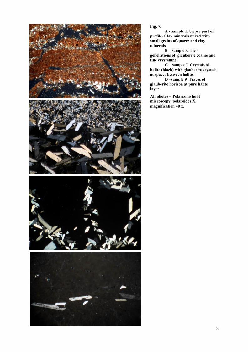
Fig. 7. A - sample 1. Upper part of
profile. Clay minerals mixed with small grains of quartz and clay minerals.
B – sample 3. Two generations of glauberite coarse and fine crystalline.
C – sample 7. Crystals of halite (black) with glauberite crystals at spaces between halite.
D –sample 9. Traces of glauberite horizon at pure halite layer.
All photos – Polarizing light microscopy, polaroides X, magnification 40 x.
9
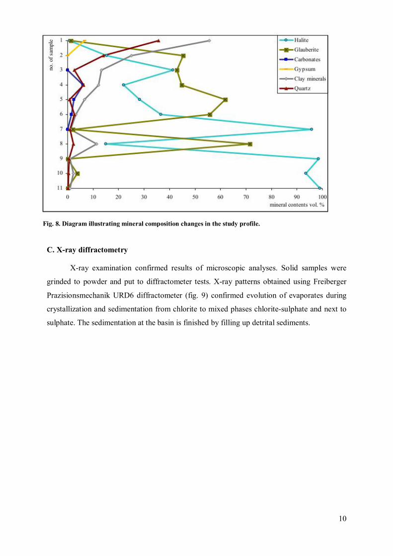
B. Microscopic examination
Microscopic examinations were performed using POLMI A polarizing light
microscope. Thin sections were obtained by cutting samples with the use of diamond cutter
followed by polishing these thin plasters. Lastly, samples were fixed on glass.
Together with microscopic observations of structures and textures, the counting of
mineral composition of samples was performed (fig. 7). Mineral composition of tested
sediments was evaluated from the bottom sediments to the top. At the lower part of profile
mostly coarse crystalline halite was determined. Higher up are present mixtures of medium or
fine halite and fine crystallized glauberite. The amount of glauberite is higher up
continuously growing to the top of evaporate sequence (tab. 1, fig. 8). Upper part of profile is
composed first of all of gluberite mixed with detrital material represented by quartz and clay
minerals. Sediments at this part contain traces of halite and gypsum. The top sediments of
profile are composed only of detrital material i.e. clay minerals and quartz with traces of
halite penetrating these sediments and crystallizing from liquids migrating, due to sun heating,
up from deeper evaporates.
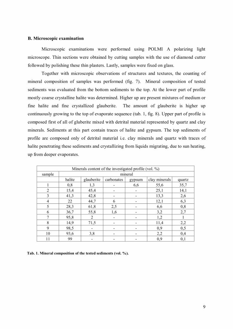
Tab. 1. Mineral composition of the tested sediments (vol. %).
10
C. X-ray diffractometry
X-ray examination confirmed results of microscopic analyses. Solid samples were
grinded to powder and put to diffractometer tests. X-ray patterns obtained using Freiberger
Prazisionsmechanik URD6 diffractometer (fig. 9) confirmed evolution of evaporates during
crystallization and sedimentation from chlorite to mixed phases chlorite-sulphate and next to
sulphate. The sedimentation at the basin is finished by filling up detrital sediments.
Fig. 8. Diagram illustrating mineral composition changes in the study profile.

11
Fig. 9A. The X-ray powder diffraction patterns of examined samples: 1, 3, and 6.

12
Fig. 9A. The X-ray powder diffraction patterns of examined samples: 8, 9 and 10.
13
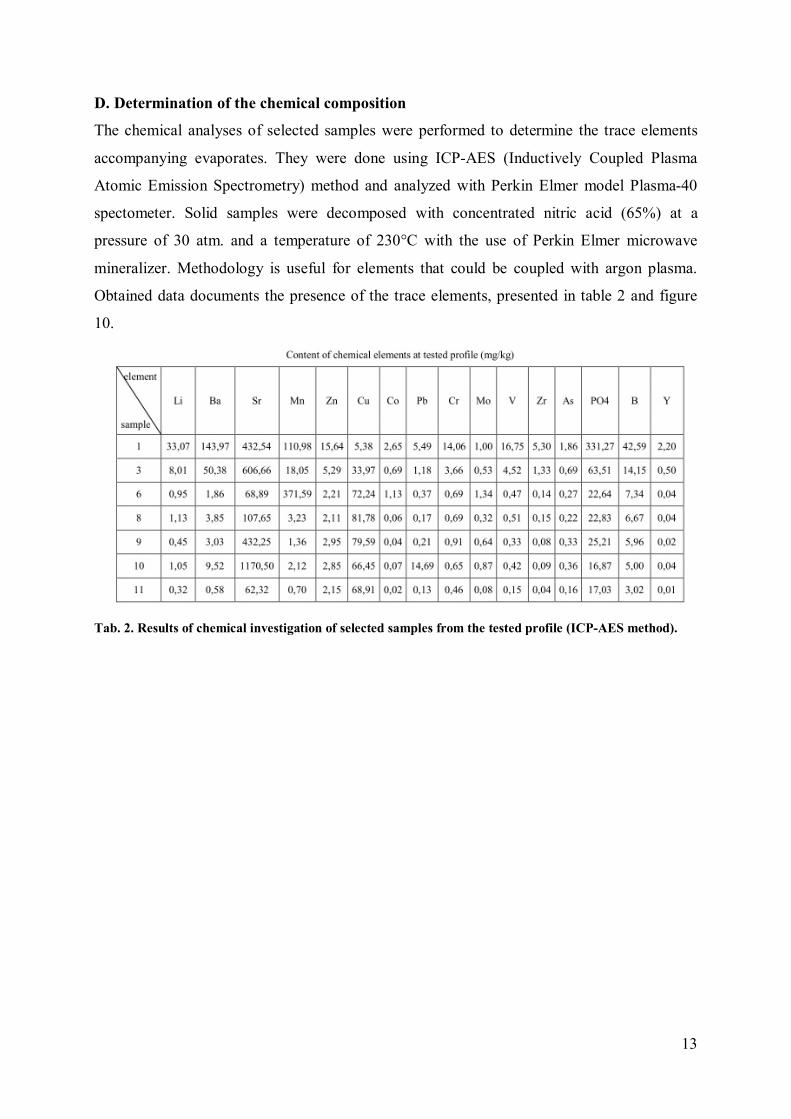
D. Determination of the chemical composition
The chemical analyses of selected samples were performed to determine the trace elements
accompanying evaporates. They were done using ICP-AES (Inductively Coupled Plasma
Atomic Emission Spectrometry) method and analyzed with Perkin Elmer model Plasma-40
spectometer. Solid samples were decomposed with concentrated nitric acid (65%) at a
pressure of 30 atm. and a temperature of 230°C with the use of Perkin Elmer microwave
mineralizer. Methodology is useful for elements that could be coupled with argon plasma.
Obtained data documents the presence of the trace elements, presented in table 2 and figure
10.
Tab. 2. Results of chemical investigation of selected samples from the tested profile (ICP-AES method).

14
Fig. 10. Diagrams illustrating trace elements content in the study profile.

15
Results
As one could see at the studied profile (fig. 4) layers containing mainly halite are
intercalated with detrital material containing glauberite. It is also visible that generally upper
part of the profile is more glauberite rich than a bottom part. Microscopic examinations of
collected samples show also that glauberite content is higher in thinner halite layers (fig. 4,
samples III-VI). Thick halite layers (fig. 4, samples VII and IX-XI) consist of almost pure
NaCl with no glauberite impurity or with a very low glauberite presence (Tab. 1, fig. 8). The
exception is sample no. VIII, thick layer of halit with the highest glauberite presence, as well
as clay minerals. The middle part of the profile (Tab. 1 & fig. 8, samples no. IV-VI) contains
also some carbonates. In the upper part of the profile (Tab. 1 & fig. 8, samples no. I-II) we
can see the transition into sulphate deposition and detrical sedimentation. Especially clay
minerals content is growing in the upper part of the profile, begining from the sample no. VI
(Fig. 8). Sediments in the upper part of the profile (samples no. I-II) contain traces of halite
and gypsum. The top sediments of profile are composed only of detrital material i.e. clay
minerals and quartz with traces of halite penetrating these sediments and crystallizing from
liquids migrating, due to sun heating, up from deeper evaporates.
Glauberite as sulphate is grystallizing elaier than halite. It is mostly present at lake
evaporites and rare as primary at sea deposits.
The X-ray examination confirmed results of microscopic analyses. The upper part of
the profile shows transition from chlorite to mixed phases chlorite-sulphate and next to
sulphate. The sedimentation at the basin is finished by filling up detrital sediments.
The trace elements that accompanying evaporates could also tell us about
environmental changes during crystallization and sedimentation in the basin. Sample no. X is
rich in strontium, molybdenium and lead. Strontium is also present in sample no. IX.
Moreover sample no. VI is interesting and contain trace elements as follow: copper,
manganese, cobalt and molybdenium. Copper is present in the lower part of the profile, below
the sample no. VI. In the upper part of the profile (samles I-III) we can observe upward
increase of some trace element content like: Sr, Pb, Cr, Zn, Zr, Y, As V, B, Li, Co, Mo, PO4 ,
Ba and Mn.
The amount and kind of elements present at tested evaporites confirm strong influence
of rocks surounding lake on evaporite chemistry. Most of typical sea evaporites das not
contains elements determined at examined salts.
Disscusion

16
Detailed results of sedimentological, mineralogical and petrological investigations of
Taoudenni-Agorgott evaporates were published by Mees (1998, 1999). Salt lake deposits
consist mainly sediments with a high glauberite (Na2Ca(SO4)2) content and in a lesser degree
salt beds containing bloedite (Na2Mg(SO4)2·4H2O), thenardite (Na2SO4) or halite (NaCl).
They formed in a perennial lake that experienced a gradual decrease in water depth. Textural
features in glauberite rich parts of the palaeolake profile are showing variations in glauberite
content and crystal size, that is reflecting depth of the water due to changes in water supply
and to short-term variations in evaporation rates. Layering deposits were formed in shallow
water, whereas unstratified deposits were produced during high lake level stages. Also halite
textures indicate changes in water depth and short-term variations in evaporation rates. The
oldest halite beds are largely unaltered cumulate deposits, whereas the youngest layers
developed exclusively through bottom growth (Mees, 1999). Results of our examinations
generally confirm results of the previous works published by Mees (1998, 1999). The studied
profile is almost identical to that one from the Mees works, although there is a distance of at
least few hundred meters between both tested sites. The minerals textures, as well as mineral
and chemical composition of correlated samples are also very similar.
Conclusions
The mineral sequences of the tested profile suggest that the deposit is a result of
repeated evaporation cycles, probably connected with the climatic fluctuation. Mineral
composition of the upper part of the profile confirmed that Na-Cl reach like waters evolved to
Na-Ca-SO4 (D’Ans, 1933, Birchert & Muir, 1964). At the final phase of the lake existence
water totally evaporated and the area was coated with detrital sediments.
Described sequence of sedimentation reflects climate changes (Pawlikowski, 1976,
1983) i.e. drying - desertation of the Sahara with some moister intervals. Precise
determination of phases of mentioned process is impossible at this stage of investigation and
needs more examination. Determination of the origin of lake is difficult as well. Chemical
composition of sediments showed the lake was not connected with the sea. On the other hand,
surrounding rocks are only subordinate built of minerals containing Na, Ca, Cl and SO4. They
represent mainly various detrital sediments, in lesser degree limestone or others rocks.
Because of this one can suppose the origin and salinity of the lake as the result of migration
and evaporation of deep, mineralized groundwaters (Kucha & Pawlikowski, 1986).

17
Literature
BORCHERT H. and MUIR R.O. (1964) - Salt deposits. The origin, matamorphism and deformation of evaporites. D. Van Nostrand Co. London-New York. CANALS-SABATE A., TOURAY J.C. and FABRE J. (1990) - Fluid inclusions in thenardite from northern Mali: experimental stretching and microthermometric investigations. Mineralogical Magazine, 54: 305-309. D’ANS J. (1933) - Die losungsgleichgewichte der System der Salze oceanischer Salzblagerungen. Verlagsgesellschaft fur Ackerbau. M.B.H., Berlin. DELIBRIAS G., FONTUGNE M. and ARNOLD M. (1991) - Datation par le carbone 14. In: Petit-Maire, N. (Ed.), Paléoenvironnements du Sahara. Lacs Holocénes à Taoudenni (Mali). CNRS, Paris: 177–179. DZIUBIŃSKI A. (1983) - Historia Maroka. Ossolineum, Wrocław. FABRE J. (1983) - Le Sahara malien septentrional (22o–24oN): Taoudenni–Trhaza. Esquise stratigraphique préliminaire des dépôts lacustres quaternaires. In: Petit-Maire, N., Riser, J. (Eds.), Sahara ou Sahel? Quaternaire récent du Bassin de Taoudenni (Mali). Lamy, Marseille: 421–439. FABRE J. (1991a) - Le lac Holocéne de Taoudenni–Agorgott. Cadre géologique et évolution. In: Petit-Maire, N. (Ed.), Paléoenvironnements du Sahara. Lacs Holocénes à Taoudenni (Mali). CNRS, Paris: 117–130. FABRE J. (1991B) - Formations Holocénes et substratum pré-Quaternaire. In: Petit-Maire, N. (Ed.), Paléoenvironnements du Sahara. Lacs Holocénes à Taoudenni (Mali). CNRS, Paris: 23–29. FABRE J. and PETIT-MAIRE N. (1988) - Holocene climatic evolution at 22–23oN from two palaeolakes in the Taoudenni area (northern Mali). Palaeogeography, Palaeoclimatology, Palaeoecology, 65: 133–148. FABRE J. (eds.) (2005) - Géologie du Sahara occidental et central. Musée Royal de l’Afrique Centrale, Tervuren, Belgique. GASSE F. (2002) - Diatom-inferred salinity and carbonate oxygen isotopes in Holocene waterbodies of the western Sahara and Sahel (Africa). Quaternary Science Reviews, 21: 737-767. GOLONKA J., KROBICKI M., PAJĄK J., GIANG N.V. and ZUCHIEWICZ W. (2006) - Global Plate Tectonics and Paleogeography of Southeast Asia. Faculty of Geology, Geophysic and Environmental Protection, AGH University of Science and Technology, Arkadia, Kraków. GUIRAUD R., BOSWORTH W., THIERRY J. and DELPLANQUE A. (2005) - Phanerozoic geological evolution of Northern and Central Africa: An overview. Journal of African Earth Sciences, 43: 83–143.

18
KUCHA H. and PAWLIKOWSKI M. (1986) - Two-brine model of the genesis of strata -bound Zechstein deposits /Kupferschifer type, Poland. Mineralium Deposita, 21: 70-80. LE VERATI C., BERTRAND H. and FÉRAUD G. (2005) - The farthest record of the Central Atlantic Magmatic Province into West Africa craton: Precise 40Ar/39Ar dating and geochemistry of Taoudenni basin intrusives (northern Mali). Earth and Planetary Science Letters, 235: 391– 407. MEES F. (1998) - The alternation of glauberite in lacustrine deposits of the Taoudenni–Agorgott basin, northern Mali. Sedimentary Geology, 117: 193–205. MEES F. (1999) - Textural features of Holocene perennial saline lake deposits of the Taoudenni–Agorgott basin, northern Mali. Sedimentary Geology, 127: 65–84. OXNEVAD I. (1991) - Sedimentology of the Taoudenni–Agorgott palaeolake. In: Petit-Maire, N. (Ed.), Paloenvironnements du Sahara. Lacs Holocénes à Taoudenni (Mali). CNRS, Paris: 131–138. PAJĄK J. (2009) - Solna karawana (Timbuktu - Taoudenni, Mali). In: Urbanik, A. (Ed.), Przez Świat: Informacje Turystyczne z Całego Świata, Tom XIII. Agencja Travelland, Kraków: 181-192.
PAJĄK J. (2010) - Po białe złoto Sahary. National Geographic Traveler, 9: 33-39.
PAJĄK J. (2011) - Po białe złoto Sahary. In: Żukowska, B. (Ed.), Adventure. 17 niesamowitych wypraw. Tom: 1. Wydawnictwo National Geographic: 177-183.
PAWLIKOWSKI M. (1976) - Studium mineralogiczno-petrograficzne utworów terrygeniczno-chemicznych złoża solnego Wieliczki. Prace Mineralogiczne, 56: 67-123. PAWLIKOWSKI M. (1983) - Studium mineralogiczno-petrograficzne produktów przeobrażeń gipsów mioceńskich w złożu siarki Wydrza. Prace Mineralogiczne, 72: 1-59. PETIT-MAIRE N., FABRE J., CARBONEL P., SCHULZ E. and AUCOUR A.M. (1987) - La dépression de Taoudenni (Sahara malien) à l’Holocéne. Géodynamique, 2 : 154–160. PRZYBYLEK J. (1993) - Hydrogeologia Sahary w Rejonie Masywu Eglab (Algierska Sahara Zachodnia). WN UAM, Poznań. SCHULZ E. (1991a) - The Taoudenni–Agorgott pollen record and the Holocene vegetation history of the central Sahara. In: Petit-Maire, N. (Ed.), Paléoenvironnements du Sahara. Lacs Holocénes à Taoudenni (Mali). CNRS, Paris: 143–162. SCHULZ E. (1991b) - Paléoenvironnement dans le Sahara central pendant l’Holocéne. Palaeoecol. Afr., 22: 191–201. TYMOWSKI M. (1979) - Historia Mali. Ossolineum, Wrocław. VILLENEUVE M. (2005) - Paleozoic basins in West Africa and the Mauritanide thrust belt. Journal of African Earth Sciences, 43: 166–195.