Embed Size (px)
Citation preview
ArticleArticleBull. Volcanol. Soc. Japan
Vol. /, (,**1) No. 0, pp. ,23�-*3
Volcano-tectonic Earthquakes during the Stage of Magma Accumulation
at the Aira Caldera, Southern Kyushu, Japan
Sri HIDAYATI�, Kazuhiro ISHIHARA��and Masato IGUCHI��
(Received, December ,*, ,**0 ; Accepted, September +., ,**1)
At Sakurajima volcano, activity of volcano-tectonic (VT) earthquakes has gradually increased since ,**,, as
the inflation of the Aira caldera progressed since +33-. In particular, VT earthquakes SW o# the volcano and in
the caldera swarmed during November ,**-�February ,**., and then a baseline of GPS across the volcano
indicated a significant extension. However, no significant increase in eruptive activity was observed. Location and
focal mechanism of VT earthquakes, which occurred during +332�,**/, are determined and the relationship
between the seismic activity of VT earthquakes and volcanic activity is discussed. The VT earthquakes originated
in an elongated zone extending in NE-SW direction, namely from the NE part of the Aira caldera through
Sakurajima volcano to SW o# the volcano. This zone coincides with active tectonic zone. The focal zones of VT
earthquakes are distinguished into three regions : (+) * to . km deep beneath the summit of Sakurajima, (,) 0 to
3 km deep SW o# the volcano, and (-) . to +. km deep in the Aira caldera. At the summit area, VT earthquakes
occurred mostly south of the crater and a few located north, and very few VT earthquakes were found inside the
crater. Focal mechanism of VT earthquakes beneath the summit area has variation with depth. Reverse fault type
was dominantly obtained at depths from * to , km. Meanwhile at deeper portion of ,�. km, strike-slip fault type
is predominant. In contrast, most of VT earthquakes SW o# Sakurajima indicated uniquely normal fault type with
horizontal T-axes oriented to WNW-ESE direction. Whereas the mechanism of those in the Aira caldera is
strike-slip types which one of the nodal lines oriented in NE-SW direction. These are consistent with regional
stress field and direction of depression zone inferred from geological study. A hypothetical model adding a tensile
fault to dual Mogi’s pressure source is proposed to examine the relation of inflation of Aira caldera and the
following seismicity SW o# the volcano.
Key words : Sakurajima volcano, volcano-tectonic earthquake, ground deformation, magma supply system
+. Introduction
Various types of earthquakes are observed at active
volcanoes. From the nature of waveform, Minakami
(+31.) classified volcanic earthquakes into four types :
A-type, B-type, explosion earthquakes and tremors.
A-type earthquakes usually originate beneath the vol-
canoes at the range of depth from + km to ,* km. Their
waveform is similar to shallow tectonic earthquakes,
and P- and S-phases of seismic waves are clearly rec-
ognized. On the other hand, B-type earthquakes occur
at shallow depth and their S-phases are not clear. On
the basis of source mechanism, Latter (+32+) reclassified
earthquakes observed at Ruapehu and Ngauruhoe vol-
canoes into two groups, “volcanic” and “tectonic” types.
“Volcanic” type usually has emergent onset with poorly-
defined phases and originates in partially molten materi-
al by some extended source mechanism. This category
includes B-type, explosion earthquakes and tremor in
the Minakami’s classification. “Tectonic” type is charac-
terized by sharp onset and well-defined phases. A term
“volcano-tectonic” is proposed to distinguish between
earthquakes of “tectonic” type originate on or beneath
volcanoes and those which occur at some distance.
“Volcano-tectonic” type takes place in competent rock
as a result of some instantaneous source mechanism.
This category covers Minakami’s A-type. The terminol-
ogy of volcano-tectonic (VT) earthquakes has been widely
used instead of A-type earthquakes. In the present
study, the terminology of volcano-tectonic earthquakes
will be used instead of A-type earthquake, although
A-type has been used at Sakurajima volcano.
An increase in VT earthquake activity is often an
early sign of volcanic unrest and potentially leading to
eruption. At Merapi volcano, occurrence of VT earth-
�
��
Center for Volcanology and Geological Hazard Miti-
gation, Jl. Diponegoro /1 Bandung .*+,,, Indonesia.
Sakurajima Volcano Research Center, DPRI, Kyoto
University, Sakurajima-Yokoyamacho, Kagoshima 23+�
+.+3, Japan.
Corresponding author : Sri Hidayati
e-mail : [email protected]
quakes preceded the increase in Multiphase (MP)
events which are related to formation of lava dome
(Hidayati et al., +332 ; Ratdomopurbo, +33/). Increase
in VT earthquakes and their hypocenter migration
toward the summit were also observed prior to +33*�+33. eruption at Unzen volcano (Umakoshi et al., ,**+).
However, increase in VT earthquakes is not necessarily
accompanied with eruption. For examples, Guntur
volcano, Indonesia (Suantika et al., +332) and Mt. Ve-
suvius, Italy (De Natale et al., ,***) have experienced
several significant increases in VT events during their
long-time dormant period, but eruptions have not taken
place yet since +2.1 and +3.., respectively. Thus,
relationship between VT earthquakes and the dynamics
of volcanoes is still unclear. Therefore, VT seismicity
could be a long-term sign of potential unrest as well as
a good short-term indicator (Chouet, +330).
Seismic events originating at Sakurajima volcano have
been conventionally classified into A-type, B-type, ex-
plosion earthquakes and C-type tremor. A-type earth-
quakes, namely VT earthquakes have often preceded
swarms of B-type earthquakes and the following repeat
of explosive eruptions (Kamo, +312). The swarm of
B-type earthquakes is inferred to be related to extrusion
of lava to the summit crater (Nishi, +32.). VT earth-
quakes have originated mostly beneath the summit and
occasionally in a deeper zone SW o# the volcano (Nishi,
+312). The foci of VT earthquakes occasionally mi-
grated from deep SW o# to shallow part beneath the
volcano before eruptive activity increased (Kamo,
+312). This suggested a magma pathway from SW of
Sakurajima. In addition, ground deformation studies
have indicated magma pathway from the Aira caldera,
north of the Sakurajima (Eto, +301 ; Mogi, +3/2 ;
Yokoyama, +320 ; Yoshikawa, +30+). Based on seismo-
logical and ground deformation studies, Kamo (+323)
proposed a model composed of , magma paths to ex-
plain the volcanic process at Sakurajima volcano. One
is from the northern part beneath the Aira caldera and
the other from the southern part which is inferred by
hypocenter migration of VT earthquakes from deep SW
o# to shallow part beneath the volcano.
Locations of VT earthquakes beneath the summit of
the volcano are separated from those of the other types
of volcanic earthquake ; BH-type, BL-type and explo-
sion earthquakes (Iguchi, +33.). VT earthquakes en-
close the hypocentral zone of the other types of volcanic
earthquakes and the zone suggests a vertically elongated
magma conduit (Ishihara, +33*). Iguchi (+33.) deter-
mined source mechanism of these earthquakes. VT
earthquakes have a faulting source and originate in
competent rock, while BH-type, BL-type and explosion
earthquakes are caused by the release of volumetric
strain related to the expansion process of a gas pocket
along the conduit. Nishi (+312) found temporal change
of the mechanism of VT earthquakes beneath the summit
with eruptive activity. Normal fault type predominantly
occurred when eruptive activity began to increase, and
reverse fault type occurred while the activity declined.
During the period of +310-+312, VT earthquakes fre-
quently occurred SW o# the Sakurajima (Kamo, +312),
however, fault plane solutions of the VT earthquakes
could not be determined due to insu$cient coverage of
seismic stations. Focal mechanisms of VT earthquakes
were not clear except for the summit area.
The previous studies on VT earthquakes were mostly
carried out during the deflation stage of the Aira calde-
ra. The deflation of Aira caldera turned inflation in
+33- (Eto et al., +332) and seismicity of VT earthquakes
has sometimes increased since then. In the present study,
we will determine hypocenter and focal mechanism of
VT earthquakes originating at Sakurajima volcano and
its surroundings during the inflation stage of the calde-
ra, and examine relationship of VT earthquakes with
volcanic activity. In particular, volcanological implica-
tions of VT earthquakes out of the summit area of
Sakurajima will be discussed in relation to tectonic
setting and volcanic activity.
,. Activity of Sakurajima volcano
The Aira caldera occupies the northern part of Kago-
shima Bay. Hayasaka (+321) revealed that the origin of
the bay dates back to certain age far older than the
formation of the calderas and was attributed to the
formation of an elongated depression from north to
south accompanied with large scale tectonic activities as
illustrated in Fig. +. A submarine volcano, Wakamiko
is located at NE part of the caldera. At the southern
rim of the caldera, Sakurajima volcano is located as a
post-caldera cone which has grown to its present eleva-
tion of about ++** m. An E-W cross section of the south-
ern part of the Aira caldera showed that Sakurajima
volcano lies on the graben formed by normal faults
(Aramaki, +32.).
Sakurajima volcano has experienced flank and summit
eruptions during historic times. Large eruptions with
e#usion of lava took place in +.1+-+.10, +113 and +3+..
The +113 eruption was accompanied with submarine
eruption at NE o# the volcano, and several new islets
were formed. The current eruptive activity started in
+3//, and it is characterized by explosive eruption of
Vulcanian type at the summit crater, Minamidake.
From +31. to +33,, the ground around the Aira
caldera gradually subsided as detected by precise level-
ing measurement showing *.+- m subsidence (BM S,0referring to BM S+1) at northern part of Sakurajima,
while hundreds number of explosive eruptions and
dozen million tons of volcanic ash were ejected a year,
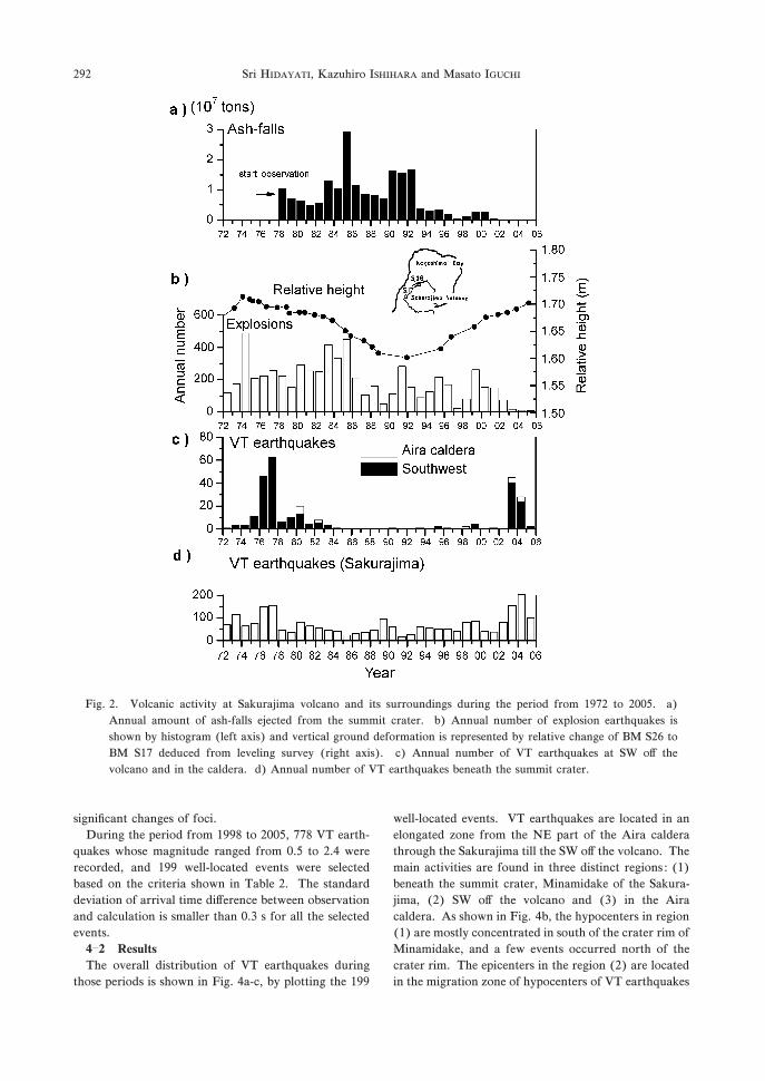
as shown in Fig. ,. During the period, number of VT
earthquakes has gradually decreased. In particular,
Sri HIDAYATI, Kazuhiro ISHIHARA and Masato IGUCHI290

seismicity of VT earthquakes out of Sakurajima has
significantly decayed as deflation of the caldera has
progressed. In +33-, eruptive activity and ash ejection
declined significantly, and the deflation of the ground
turned inflation, as illustrated in Fig. ,. It is interpreted
that magma accumulation resumed at the magma reser-
voir beneath the caldera (Eto et al., +332). Meanwhile,
number of VT earthquakes originating beneath the
summit has gradually increased since ,**,. In Novem-
ber ,**-, ,0 VT earthquakes occurred SW o# the
volcano and the seismicity continued until February
,**.. Furthermore, in December ,**-, while the seis-
mic activity still persisted, several earthquakes originated
in the caldera, where few events have been detected
since +32,. However, no significant change in eruptive
activity was observed, in spite of increase in seismicity
of VT earthquakes.
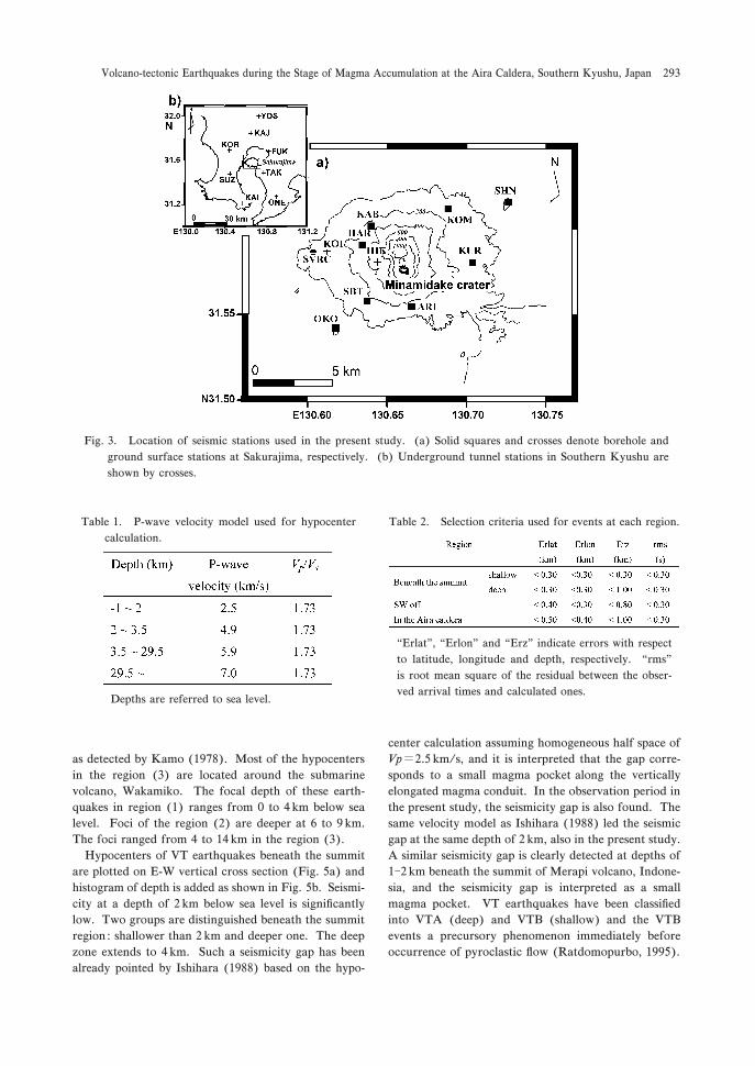
-. Seismic observation
Sakurajima Volcano Research Center (SVRC) of Kyoto
University has monitored seismic activity of the volcano
by +2 stations (Fig. -). Ten stations are distributed in a
range of 1 km from the active crater of Sakurajima
volcano (Fig. -a). Most of them are borehole stations,
except for HIK and KOI, where seismometers are in-
stalled on the ground surface ones. All the stations are
equipped with --component short-period (+ Hz) seis-
mometer and seismic signals are transmitted by tele-
phone line and radio waves to SVRC. Wider network
(Fig. -b) is composed of 2 stations located outside
Sakurajima volcano in Southern Kyushu, and also equi-
pped with --component short-period seismometer. All
the seismic signals are transmitted by telephone line to
SVRC.
The seismic signals were recorded on analogue mag-
netic tapes in trigger method before May ,**+, and they
were digitized with a sampling rate of ,** Hz for
analysis in this study. Since ,**+, the data have been
transformed in digital form at a sampling rate of ,** Hz
continuously at the stations.
.. Hypocenter
.�+ Method
To calculate hypocenter location, a velocity model
composed of three layers over a half space was assumed
as listed in Table +, based on the model proposed by
Yamasato (+321). A value of +.1- was assumed as Vp/
Vs ratio for all the layers. Location of VT earthquakes
was calculated by HYPOELLIPSE program (Lahr, +333).
In order to minimize time-picking errors, calculation
was done for events whose P-wave first motions were
clearly recorded at more than 2 stations for VT events at
the volcano and more than +. stations for those out of
Sakurajima. Calculation stability was examined by
varying initial depths of +, -, / and 1 km to confirm no
Fig. +. Map of subsurface geology of Kagoshima
Bay, Southern Kyushu, Japan. Aira caldera and
Sakurajima volcano is shown (Hayasaka, +321,
with slightly modified expression). + : basement ;
, : nearly horizontal strata continue to +/*�,**m below sea level, overlain by recent deposits ;
- : thin parallel strata continue to depth of ,**�-** m through recent deposit. This deposit buries
a depression feature like a valley ; . : probably
fore-set deposits of deltas overlain by recent
deposits ; / : non stratification material overlain
by recent deposits /*�2* m thick ; 0 : dike.
Volcano-tectonic Earthquakes during the Stage of Magma Accumulation at the Aira Caldera, Southern Kyushu, Japan 291
significant changes of foci.
During the period from +332 to ,**/, 112 VT earth-
quakes whose magnitude ranged from *./ to ,.. were
recorded, and +33 well-located events were selected
based on the criteria shown in Table ,. The standard
deviation of arrival time di#erence between observation
and calculation is smaller than *.- s for all the selected
events.
.�, Results
The overall distribution of VT earthquakes during
those periods is shown in Fig. .a-c, by plotting the +33
well-located events. VT earthquakes are located in an
elongated zone from the NE part of the Aira caldera
through the Sakurajima till the SW o# the volcano. The
main activities are found in three distinct regions : (+)
beneath the summit crater, Minamidake of the Sakura-
jima, (,) SW o# the volcano and (-) in the Aira
caldera. As shown in Fig. .b, the hypocenters in region
(+) are mostly concentrated in south of the crater rim of
Minamidake, and a few events occurred north of the
crater rim. The epicenters in the region (,) are located
in the migration zone of hypocenters of VT earthquakes
Fig. ,. Volcanic activity at Sakurajima volcano and its surroundings during the period from +31, to ,**/. a)
Annual amount of ash-falls ejected from the summit crater. b) Annual number of explosion earthquakes is
shown by histogram (left axis) and vertical ground deformation is represented by relative change of BM S,0 to
BM S+1 deduced from leveling survey (right axis). c) Annual number of VT earthquakes at SW o# the
volcano and in the caldera. d) Annual number of VT earthquakes beneath the summit crater.
Sri HIDAYATI, Kazuhiro ISHIHARA and Masato IGUCHI292
as detected by Kamo (+312). Most of the hypocenters
in the region (-) are located around the submarine
volcano, Wakamiko. The focal depth of these earth-
quakes in region (+) ranges from * to . km below sea
level. Foci of the region (,) are deeper at 0 to 3 km.
The foci ranged from . to +. km in the region (-).
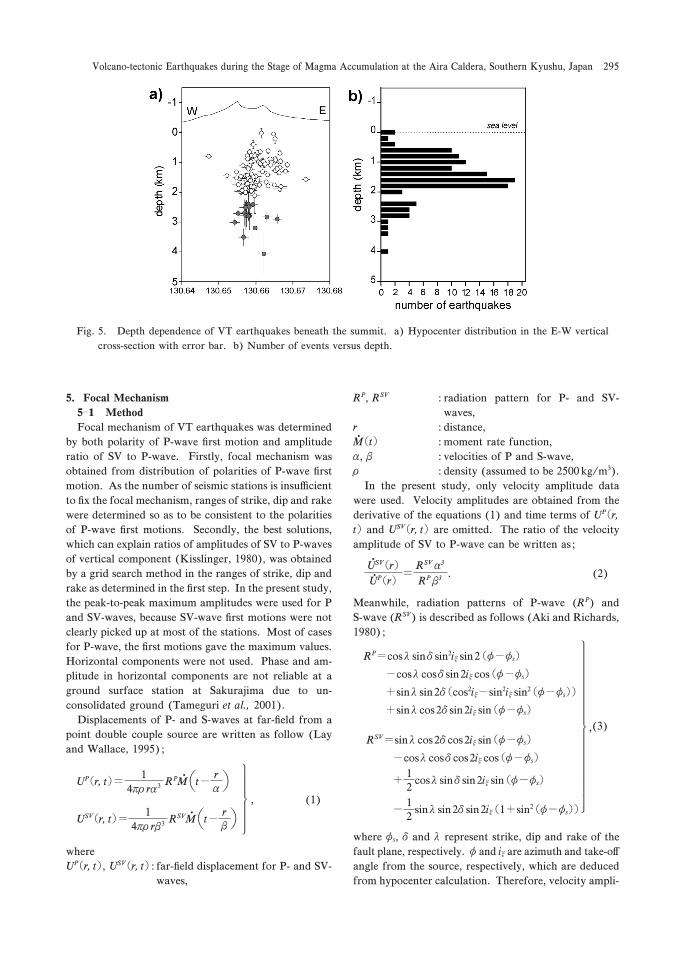
Hypocenters of VT earthquakes beneath the summit
are plotted on E-W vertical cross section (Fig. /a) and
histogram of depth is added as shown in Fig. /b. Seismi-
city at a depth of , km below sea level is significantly
low. Two groups are distinguished beneath the summit
region : shallower than , km and deeper one. The deep
zone extends to . km. Such a seismicity gap has been
already pointed by Ishihara (+322) based on the hypo-
center calculation assuming homogeneous half space of
Vp�,./ km/s, and it is interpreted that the gap corre-
sponds to a small magma pocket along the vertically
elongated magma conduit. In the observation period in
the present study, the seismicity gap is also found. The
same velocity model as Ishihara (+322) led the seismic
gap at the same depth of , km, also in the present study.
A similar seismicity gap is clearly detected at depths of
+�, km beneath the summit of Merapi volcano, Indone-
sia, and the seismicity gap is interpreted as a small
magma pocket. VT earthquakes have been classified
into VTA (deep) and VTB (shallow) and the VTB
events a precursory phenomenon immediately before
occurrence of pyroclastic flow (Ratdomopurbo, +33/).
Fig. -. Location of seismic stations used in the present study. (a) Solid squares and crosses denote borehole and
ground surface stations at Sakurajima, respectively. (b) Underground tunnel stations in Southern Kyushu are
shown by crosses.
Table +. P-wave velocity model used for hypocenter
calculation.
Table ,. Selection criteria used for events at each region.
“Erlat”, “Erlon” and “Erz” indicate errors with respect
to latitude, longitude and depth, respectively. “rms”
is root mean square of the residual between the obser-
ved arrival times and calculated ones.Depths are referred to sea level.
Volcano-tectonic Earthquakes during the Stage of Magma Accumulation at the Aira Caldera, Southern Kyushu, Japan 293
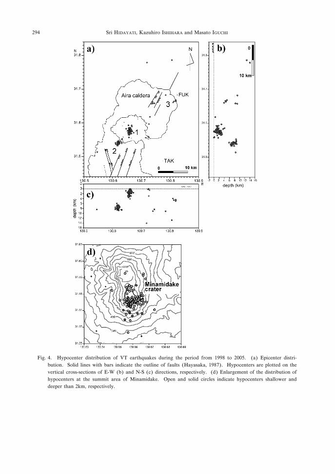
Fig. .. Hypocenter distribution of VT earthquakes during the period from +332 to ,**/. (a) Epicenter distri-
bution. Solid lines with bars indicate the outline of faults (Hayasaka, +321). Hypocenters are plotted on the
vertical cross-sections of E-W (b) and N-S (c) directions, respectively. (d) Enlargement of the distribution of
hypocenters at the summit area of Minamidake. Open and solid circles indicate hypocenters shallower and
deeper than ,km, respectively.
Sri HIDAYATI, Kazuhiro ISHIHARA and Masato IGUCHI294
/. Focal Mechanism
/�+ Method
Focal mechanism of VT earthquakes was determined
by both polarity of P-wave first motion and amplitude
ratio of SV to P-wave. Firstly, focal mechanism was
obtained from distribution of polarities of P-wave first
motion. As the number of seismic stations is insu$cient
to fix the focal mechanism, ranges of strike, dip and rake
were determined so as to be consistent to the polarities
of P-wave first motions. Secondly, the best solutions,
which can explain ratios of amplitudes of SV to P-waves
of vertical component (Kisslinger, +32*), was obtained
by a grid search method in the ranges of strike, dip and
rake as determined in the first step. In the present study,
the peak-to-peak maximum amplitudes were used for P
and SV-waves, because SV-wave first motions were not
clearly picked up at most of the stations. Most of cases
for P-wave, the first motions gave the maximum values.
Horizontal components were not used. Phase and am-
plitude in horizontal components are not reliable at a
ground surface station at Sakurajima due to un-
consolidated ground (Tameguri et al., ,**+).
Displacements of P- and S-waves at far-field from a
point double couple source are written as follow (Lay
and Wallace, +33/) ;
UP�r, t�� +.pr ra- RPM
���t� r
a��
USV�r, t�� +.pr rb- RSVM
���t� r
b��
�������
, (+)
where
UP�r, t�, USV�r, t� : far-field displacement for P- and SV-
waves,
RP, RSV : radiation pattern for P- and SV-
waves,
r : distance,
M�t��: moment rate function,
a, b : velocities of P and S-wave,
r : density (assumed to be ,/** kg/m-).
In the present study, only velocity amplitude data
were used. Velocity amplitudes are obtained from the
derivative of the equations (+) and time terms of UP�r,t� and USV�r, t� are omitted. The ratio of the velocity
amplitude of SV to P-wave can be written as ;
USV�r�UP�r�
�� �
RSV a-
RP b- . (,)
Meanwhile, radiation patterns of P-wave (RP) and
S-wave (RSV) is described as follows (Aki and Richards,
+32*) ;
RP�cosl sind sin,ix sin,�f�fs��cosl cosd sin,ix cos�f�fs��sinl sin,d�cos,ix�sin,ix sin,�f�fs���sinl cos,d sin,ix sin�f�fs�
�����������������
,(-)
RSV�sinl cos,d cos,ix sin�f�fs��cosl cosd cos,ix cos�f�fs�
� +,
cosl sind sin,ix sin�f�fs�
� +,
sinl sin,d sin,ix�+�sin,�f�fs��
where fs, d and l represent strike, dip and rake of the
fault plane, respectively. f and ix are azimuth and take-o#angle from the source, respectively, which are deduced
from hypocenter calculation. Therefore, velocity ampli-
Fig. /. Depth dependence of VT earthquakes beneath the summit. a) Hypocenter distribution in the E-W vertical
cross-section with error bar. b) Number of events versus depth.
Volcano-tectonic Earthquakes during the Stage of Magma Accumulation at the Aira Caldera, Southern Kyushu, Japan 295
tude ratio of SV to P-wave at a station x from the source
x* could be written as follows ;
USV
UP
�� �x��
RSV�fs, d, l, x*�a-
RP�fs, d, l, x*�b- . (.)
Grid search method was applied for strike, dip and
rake, so as to minimize residual of the calculated SV/P
amplitude ratios from observed ones with / degrees
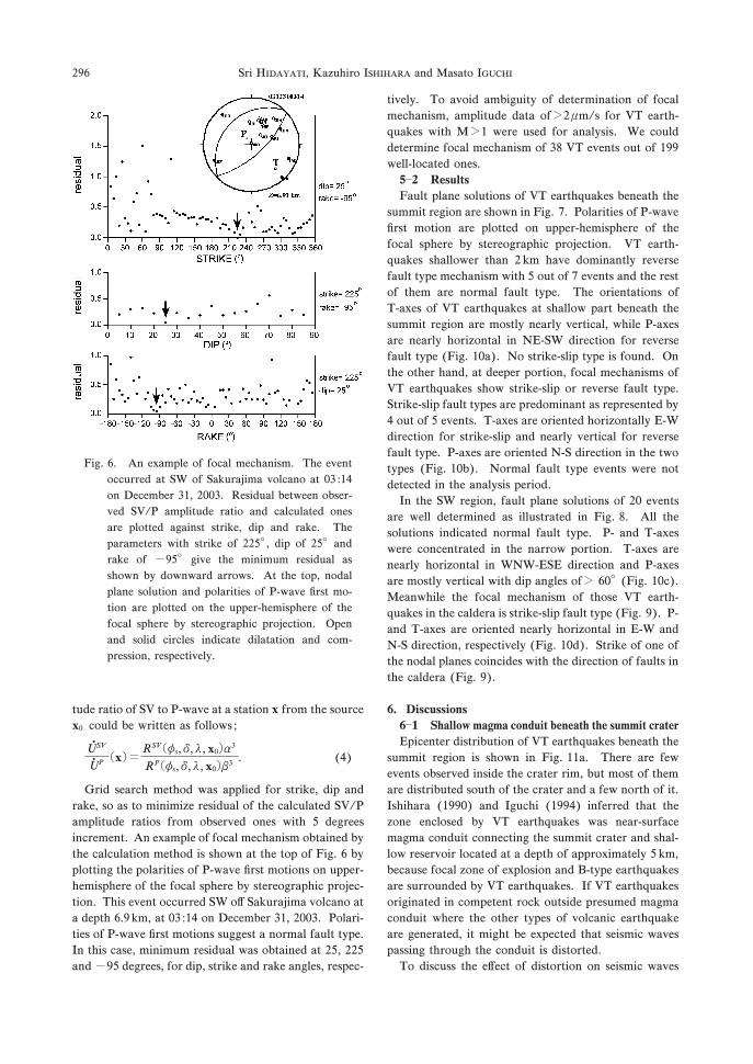
increment. An example of focal mechanism obtained by
the calculation method is shown at the top of Fig. 0 by
plotting the polarities of P-wave first motions on upper-
hemisphere of the focal sphere by stereographic projec-
tion. This event occurred SW o# Sakurajima volcano at
a depth 0.3 km, at *- :+. on December -+, ,**-. Polari-
ties of P-wave first motions suggest a normal fault type.
In this case, minimum residual was obtained at ,/, ,,/and�3/ degrees, for dip, strike and rake angles, respec-
tively. To avoid ambiguity of determination of focal
mechanism, amplitude data of�, mm/s for VT earth-
quakes with M�+ were used for analysis. We could
determine focal mechanism of -2 VT events out of +33well-located ones.
/�, Results
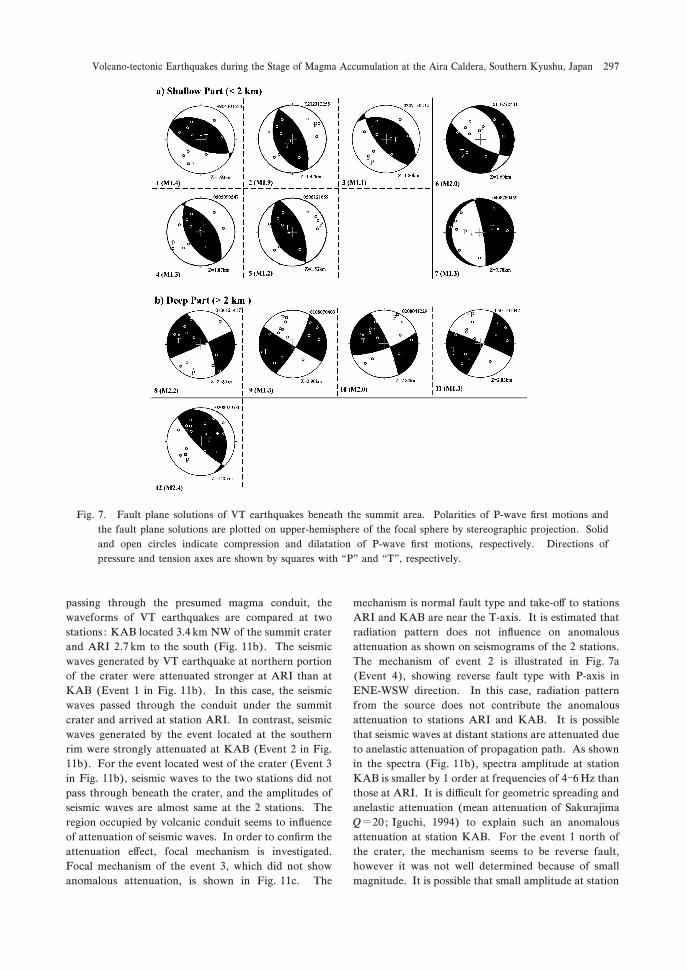
Fault plane solutions of VT earthquakes beneath the
summit region are shown in Fig. 1. Polarities of P-wave
first motion are plotted on upper-hemisphere of the
focal sphere by stereographic projection. VT earth-
quakes shallower than , km have dominantly reverse
fault type mechanism with / out of 1 events and the rest
of them are normal fault type. The orientations of
T-axes of VT earthquakes at shallow part beneath the
summit region are mostly nearly vertical, while P-axes
are nearly horizontal in NE-SW direction for reverse
fault type (Fig. +*a). No strike-slip type is found. On
the other hand, at deeper portion, focal mechanisms of
VT earthquakes show strike-slip or reverse fault type.
Strike-slip fault types are predominant as represented by
. out of / events. T-axes are oriented horizontally E-W
direction for strike-slip and nearly vertical for reverse
fault type. P-axes are oriented N-S direction in the two
types (Fig. +*b). Normal fault type events were not
detected in the analysis period.
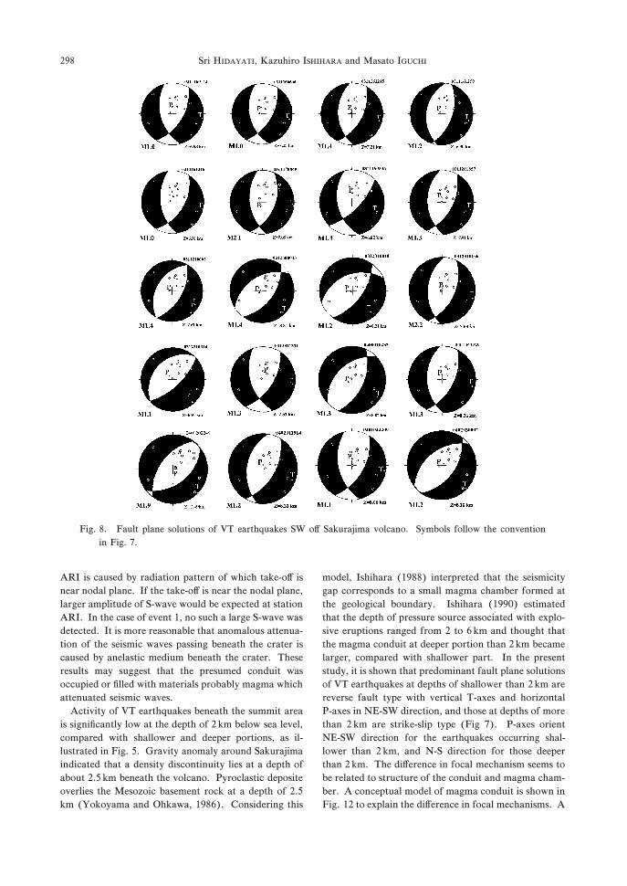
In the SW region, fault plane solutions of ,* events
are well determined as illustrated in Fig. 2. All the
solutions indicated normal fault type. P- and T-axes
were concentrated in the narrow portion. T-axes are
nearly horizontal in WNW-ESE direction and P-axes
are mostly vertical with dip angles of� 0*� (Fig. +*c).
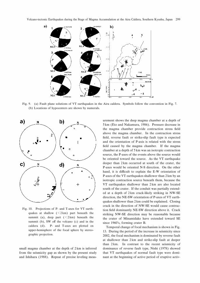
Meanwhile the focal mechanism of those VT earth-
quakes in the caldera is strike-slip fault type (Fig. 3). P-
and T-axes are oriented nearly horizontal in E-W and
N-S direction, respectively (Fig. +*d). Strike of one of
the nodal planes coincides with the direction of faults in
the caldera (Fig. 3).
0. Discussions
0�+ Shallow magma conduit beneath the summit crater
Epicenter distribution of VT earthquakes beneath the
summit region is shown in Fig. ++a. There are few
events observed inside the crater rim, but most of them
are distributed south of the crater and a few north of it.
Ishihara (+33*) and Iguchi (+33.) inferred that the
zone enclosed by VT earthquakes was near-surface
magma conduit connecting the summit crater and shal-
low reservoir located at a depth of approximately / km,
because focal zone of explosion and B-type earthquakes
are surrounded by VT earthquakes. If VT earthquakes
originated in competent rock outside presumed magma
conduit where the other types of volcanic earthquake
are generated, it might be expected that seismic waves
passing through the conduit is distorted.
To discuss the e#ect of distortion on seismic waves
Fig. 0. An example of focal mechanism. The event
occurred at SW of Sakurajima volcano at *- :+.on December -+, ,**-. Residual between obser-
ved SV/P amplitude ratio and calculated ones
are plotted against strike, dip and rake. The
parameters with strike of ,,/�, dip of ,/� and
rake of �3/� give the minimum residual as
shown by downward arrows. At the top, nodal
plane solution and polarities of P-wave first mo-
tion are plotted on the upper-hemisphere of the
focal sphere by stereographic projection. Open
and solid circles indicate dilatation and com-
pression, respectively.
Sri HIDAYATI, Kazuhiro ISHIHARA and Masato IGUCHI296
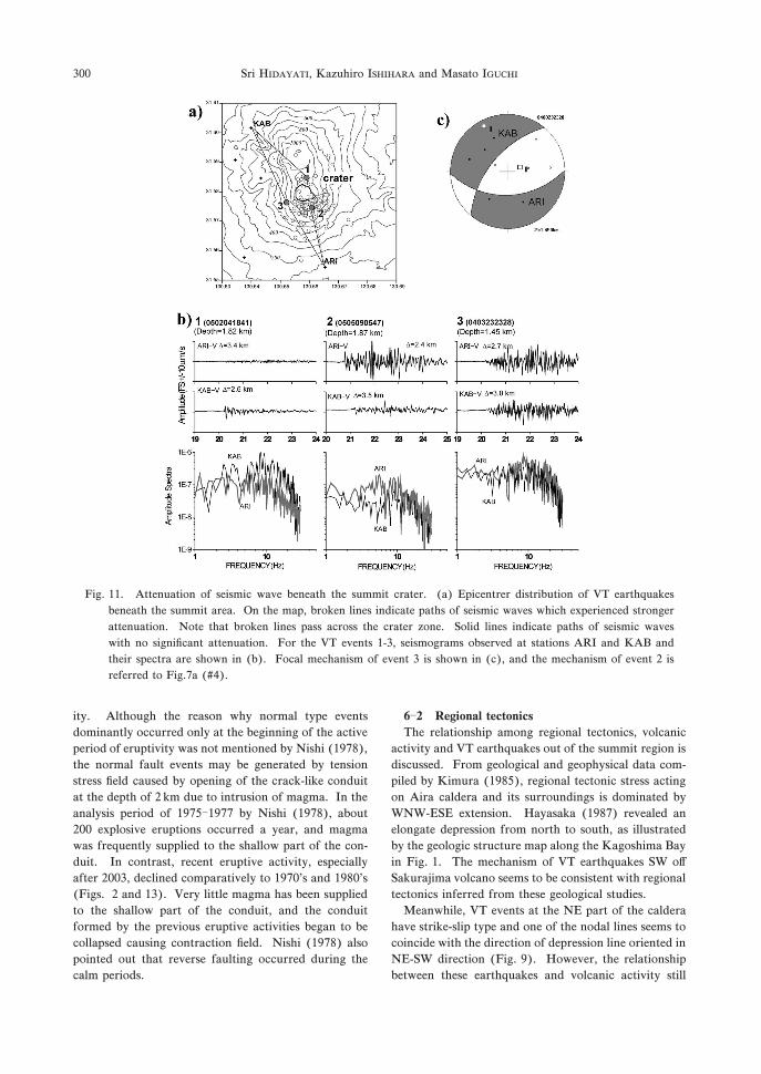
passing through the presumed magma conduit, the
waveforms of VT earthquakes are compared at two
stations : KAB located -.. km NW of the summit crater
and ARI ,.1 km to the south (Fig. ++b). The seismic
waves generated by VT earthquake at northern portion
of the crater were attenuated stronger at ARI than at
KAB (Event + in Fig. ++b). In this case, the seismic
waves passed through the conduit under the summit
crater and arrived at station ARI. In contrast, seismic
waves generated by the event located at the southern
rim were strongly attenuated at KAB (Event , in Fig.
++b). For the event located west of the crater (Event -in Fig. ++b), seismic waves to the two stations did not
pass through beneath the crater, and the amplitudes of
seismic waves are almost same at the , stations. The
region occupied by volcanic conduit seems to influence
of attenuation of seismic waves. In order to confirm the
attenuation e#ect, focal mechanism is investigated.
Focal mechanism of the event -, which did not show
anomalous attenuation, is shown in Fig. ++c. The
mechanism is normal fault type and take-o# to stations
ARI and KAB are near the T-axis. It is estimated that
radiation pattern does not influence on anomalous
attenuation as shown on seismograms of the , stations.
The mechanism of event , is illustrated in Fig. 1a
(Event .), showing reverse fault type with P-axis in
ENE-WSW direction. In this case, radiation pattern
from the source does not contribute the anomalous
attenuation to stations ARI and KAB. It is possible
that seismic waves at distant stations are attenuated due
to anelastic attenuation of propagation path. As shown
in the spectra (Fig. ++b), spectra amplitude at station
KAB is smaller by + order at frequencies of .�0 Hz than
those at ARI. It is di$cult for geometric spreading and
anelastic attenuation (mean attenuation of Sakurajima
Q�,* ; Iguchi, +33.) to explain such an anomalous
attenuation at station KAB. For the event + north of
the crater, the mechanism seems to be reverse fault,
however it was not well determined because of small
magnitude. It is possible that small amplitude at station
Fig. 1. Fault plane solutions of VT earthquakes beneath the summit area. Polarities of P-wave first motions and
the fault plane solutions are plotted on upper-hemisphere of the focal sphere by stereographic projection. Solid
and open circles indicate compression and dilatation of P-wave first motions, respectively. Directions of
pressure and tension axes are shown by squares with “P” and “T”, respectively.
Volcano-tectonic Earthquakes during the Stage of Magma Accumulation at the Aira Caldera, Southern Kyushu, Japan 297
ARI is caused by radiation pattern of which take-o# is
near nodal plane. If the take-o# is near the nodal plane,
larger amplitude of S-wave would be expected at station
ARI. In the case of event +, no such a large S-wave was
detected. It is more reasonable that anomalous attenua-
tion of the seismic waves passing beneath the crater is
caused by anelastic medium beneath the crater. These
results may suggest that the presumed conduit was
occupied or filled with materials probably magma which
attenuated seismic waves.
Activity of VT earthquakes beneath the summit area
is significantly low at the depth of , km below sea level,
compared with shallower and deeper portions, as il-
lustrated in Fig. /. Gravity anomaly around Sakurajima
indicated that a density discontinuity lies at a depth of
about ,./ km beneath the volcano. Pyroclastic deposite
overlies the Mesozoic basement rock at a depth of ,./km (Yokoyama and Ohkawa, +320). Considering this
model, Ishihara (+322) interpreted that the seismicity
gap corresponds to a small magma chamber formed at
the geological boundary. Ishihara (+33*) estimated
that the depth of pressure source associated with explo-
sive eruptions ranged from , to 0 km and thought that
the magma conduit at deeper portion than , km became
larger, compared with shallower part. In the present
study, it is shown that predominant fault plane solutions
of VT earthquakes at depths of shallower than , km are
reverse fault type with vertical T-axes and horizontal
P-axes in NE-SW direction, and those at depths of more
than , km are strike-slip type (Fig 1). P-axes orient
NE-SW direction for the earthquakes occurring shal-
lower than , km, and N-S direction for those deeper
than , km. The di#erence in focal mechanism seems to
be related to structure of the conduit and magma cham-
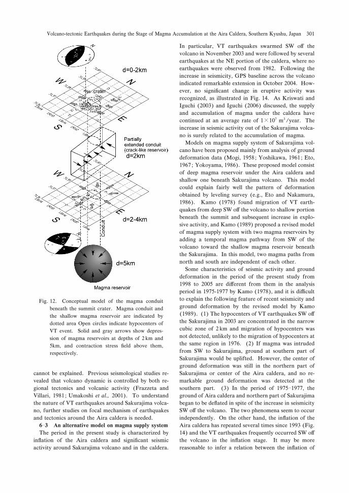
ber. A conceptual model of magma conduit is shown in
Fig. +, to explain the di#erence in focal mechanisms. A
Fig. 2. Fault plane solutions of VT earthquakes SW o# Sakurajima volcano. Symbols follow the convention
in Fig. 1.
Sri HIDAYATI, Kazuhiro ISHIHARA and Masato IGUCHI298
small magma chamber at the depth of , km is inferred
from the seismicity gap as shown by the present study
and Ishihara (+322). Repeat of precise leveling meas-
urement shows the deep magma chamber at a depth of
/ km (Eto and Nakamura, +320). Pressure decrease in
the magma chamber provide contraction stress field
above the magma chamber. In the contraction stress
field, reverse fault or strike-slip fault type is expected
and the orientation of P-axis is related with the stress
field caused by the magma chamber. If the magma
chamber at a depth of / km was an isotropic contraction
source, the P-axes of the events above the source would
be oriented toward the source. As the VT earthquake
deeper than , km occurred at south of the crater, the
P-axes would be oriented N-S direction. On the other
hand, it is di$cult to explain the E-W orientation of
P-axes of the VT earthquakes shallower than , km by an
isotropic contraction source beneath them, because the
VT earthquakes shallower than , km are also located
south of the crater. If the conduit was partially extend-
ed at a depth of , km crack-likely striking in NW-SE
direction, the NE-SW orientation of P-axes of VT earth-
quakes shallower than , km could be explained. Closing
crack in the direction of NW-SE would cause contrac-
tion field dominantly NE-SW direction above it. Crack
striking NW-SE direction may be reasonable because
the crater of Minamidake have extended toward SE
since +30*’s, forming crater B.
Temporal change of focal mechanism is shown in Fig.
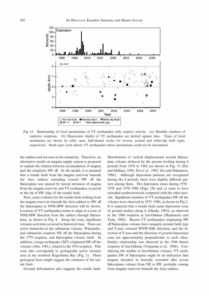
+-. During the period of the increase in seismicity since
,**,, the focal mechanism is dominated by reverse fault
at shallower than , km and strike-slip fault at deeper
than , km. In contrast to the recent seismicity of
dominance of reverse fault type, Nishi (+312) showed
that VT earthquakes of normal fault type were domi-
nant at the beginning of active period of eruptive activ-
Fig. 3. (a) Fault plane solutions of VT earthquakes in the Aira caldera. Symbols follow the convention in Fig. 1.
(b) Locations of hypocenters are shown by numerals.
Fig. +*. Projections of P- and T-axes for VT earth-
quakes at shallow (�, km) part beneath the
summit (a), deep part (�, km) beneath the
summit (b), SW o# the volcano (c) and in the
caldera (d). P- and T-axes are plotted on
upper-hemisphere of the focal sphere by stereo-
graphic projection.
Volcano-tectonic Earthquakes during the Stage of Magma Accumulation at the Aira Caldera, Southern Kyushu, Japan 299
ity. Although the reason why normal type events
dominantly occurred only at the beginning of the active
period of eruptivity was not mentioned by Nishi (+312),
the normal fault events may be generated by tension
stress field caused by opening of the crack-like conduit
at the depth of , km due to intrusion of magma. In the
analysis period of +31/�+311 by Nishi (+312), about
,** explosive eruptions occurred a year, and magma
was frequently supplied to the shallow part of the con-
duit. In contrast, recent eruptive activity, especially
after ,**-, declined comparatively to +31*’s and +32*’s
(Figs. , and +-). Very little magma has been supplied
to the shallow part of the conduit, and the conduit
formed by the previous eruptive activities began to be
collapsed causing contraction field. Nishi (+312) also
pointed out that reverse faulting occurred during the
calm periods.
0�, Regional tectonics
The relationship among regional tectonics, volcanic
activity and VT earthquakes out of the summit region is
discussed. From geological and geophysical data com-
piled by Kimura (+32/), regional tectonic stress acting
on Aira caldera and its surroundings is dominated by
WNW-ESE extension. Hayasaka (+321) revealed an
elongate depression from north to south, as illustrated
by the geologic structure map along the Kagoshima Bay
in Fig. +. The mechanism of VT earthquakes SW o#Sakurajima volcano seems to be consistent with regional
tectonics inferred from these geological studies.
Meanwhile, VT events at the NE part of the caldera
have strike-slip type and one of the nodal lines seems to
coincide with the direction of depression line oriented in
NE-SW direction (Fig. 3). However, the relationship
between these earthquakes and volcanic activity still
Fig. ++. Attenuation of seismic wave beneath the summit crater. (a) Epicentrer distribution of VT earthquakes
beneath the summit area. On the map, broken lines indicate paths of seismic waves which experienced stronger
attenuation. Note that broken lines pass across the crater zone. Solid lines indicate paths of seismic waves
with no significant attenuation. For the VT events +--, seismograms observed at stations ARI and KAB and
their spectra are shown in (b). Focal mechanism of event - is shown in (c), and the mechanism of event , is
referred to Fig.1a (#.).
Sri HIDAYATI, Kazuhiro ISHIHARA and Masato IGUCHI300
cannot be explained. Previous seismological studies re-
vealed that volcano dynamic is controlled by both re-
gional tectonics and volcanic activity (Frazzeta and
Villari, +32+ ; Umakoshi et al., ,**+). To understand
the nature of VT earthquakes around Sakurajima volca-
no, further studies on focal mechanism of earthquakes
and tectonics around the Aira caldera is needed.
0�- An alternative model on magma supply system
The period in the present study is characterized by
inflation of the Aira caldera and significant seismic
activity around Sakurajima volcano and in the caldera.
In particular, VT earthquakes swarmed SW o# the
volcano in November ,**- and were followed by several
earthquakes at the NE portion of the caldera, where no
earthquakes were observed from +32,. Following the
increase in seismicity, GPS baseline across the volcano
indicated remarkable extension in October ,**.. How-
ever, no significant change in eruptive activity was
recognized, as illustrated in Fig. +.. As Kriswati and
Iguchi (,**-) and Iguchi (,**0) discussed, the supply
and accumulation of magma under the caldera have
continued at an average rate of +�+*1 m- /year. The
increase in seismic activity out of the Sakurajima volca-
no is surely related to the accumulation of magma.
Models on magma supply system of Sakurajima vol-
cano have been proposed mainly from analysis of ground
deformation data (Mogi, +3/2 ; Yoshikawa, +30+ ; Eto,
+301 ; Yokoyama, +320). These proposed model consist
of deep magma reservoir under the Aira caldera and
shallow one beneath Sakurajima volcano. This model
could explain fairly well the pattern of deformation
obtained by leveling survey (e.g., Eto and Nakamura,
+320). Kamo (+312) found migration of VT earth-
quakes from deep SW o# the volcano to shallow portion
beneath the summit and subsequent increase in explo-
sive activity, and Kamo (+323) proposed a revised model
of magma supply system with two magma reservoirs by
adding a temporal magma pathway from SW of the
volcano toward the shallow magma reservoir beneath
the Sakurajima. In this model, two magma paths from
north and south are independent of each other.
Some characteristics of seismic activity and ground
deformation in the period of the present study from
+332 to ,**/ are di#erent from them in the analysis
period in +31/-+311 by Kamo (+312), and it is di$cult
to explain the following feature of recent seismicity and
ground deformation by the revised model by Kamo
(+323). (+) The hypocenters of VT earthquakes SW o#the Sakurajima in ,**- are concentrated in the narrow
cubic zone of , km and migration of hypocenters was
not detected, unlikely to the migration of hypocenters at
the same region in +310. (,) If magma was intruded
from SW to Sakurajima, ground at southern part of
Sakurajima would be uplifted. However, the center of
ground deformation was still in the northern part of
Sakurajima or center of the Aira caldera, and no re-
markable ground deformation was detected at the
southern part. (-) In the period of +31/�+311, the
ground of Aira caldera and northern part of Sakurajima
began to be deflated in spite of the increase in seismicity
SW o# the volcano. The two phenomena seem to occur
independently. On the other hand, the inflation of the
Aira caldera has repeated several times since +33- (Fig.
+.) and the VT earthquakes frequently occurred SW o#the volcano in the inflation stage. It may be more
reasonable to infer a relation between the inflation of
Fig. +,. Conceptual model of the magma conduit
beneath the summit crater. Magma conduit and
the shallow magma reservoir are indicated by
dotted area Open circles indicate hypocenters of
VT event. Solid and gray arrows show depres-
sion of magma reservoirs at depths of , km and
/km, and contraction stress field above them,
respectively.
Volcano-tectonic Earthquakes during the Stage of Magma Accumulation at the Aira Caldera, Southern Kyushu, Japan 301
the caldera and increase in the seismicity. Therefore, an
alternative model on magma supply system is proposed
to explain the relation between accumulation of magma
and the seismicity SW o#. In the model, it is assumed
that a tensile fault from the magma reservoir beneath
the Aira caldera extending toward SW o# the
Sakurajima was opened by lateral intrusion of magma
from the magma reservoir and VT earthquakes occurred
at the tip of SW edge of the tensile fault.
Next, some evidence for the tensile fault striking from
the magma reservoir beneath the Aira caldera to SW o#the Sakurajima in NNE-SSW direction will be shown.
Location of VT earthquakes seems to align in a zone of
NNE-SSW direction from the caldera through Sakura-
jima, as shown in Fig. .. Along the zone, significant
volcanic activities occurred in historical time. These are
active fumaroles at the submarine volcano, Wakamiko,
and submarine eruption NE o# the Sakurajima during
the +113 eruption, and Sakurajima volcano itself. In
addition, a large earthquake (M1) originated SW o# the
volcano (Abe, +32+), related to the +3+. eruption. This
zone also corresponds to geologically active tectonic
area at the northern Kagoshima Bay (Fig. +). These
geological facts might suggest the existence of the ten-
sile fault.
Ground deformation also suggests the tensile fault.
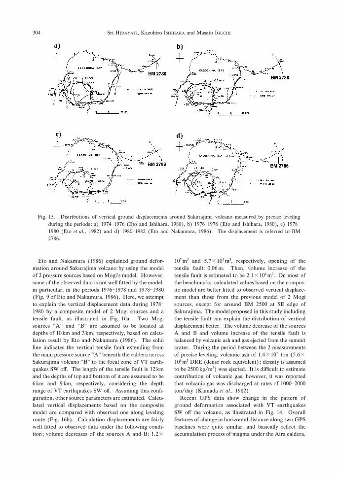
Distributions of vertical displacements around Sakura-
jima volcano deduced by the precise leveling during .periods from +31. to +32, are shown in Fig. +/ (Eto
and Ishihara, +32* ; Eto et al., +32, ; Eto and Nakamura,
+320). Although depression patterns are recognized
during the . periods, there were slightly di#erent pat-
tern among them. The depression zones during +310�+312 and +312�+32* (Figs. +/b and c) seem to have
extended southwestwards compared with the other peri-
ods. Significant numbers of VT earthquakes SW o# the
volcano were observed in +31/�+32*, as shown in Fig ,.
It is expected that a tensile fault cause depression zone
of ground surface along it (Okada, +33,), as observed
in the +320 eruption at Izu-Oshima (Hashimoto and
Tada, +322). Recent VT earthquakes originating SW
o# Sakurajima volcano have uniquely normal fault type
and T-axes oriented WNW-ESE direction, and the di-
rection of T-axes and the direction of ground depression
zone are approximately perpendicular to each other.
Similar relationship was observed in the +320 fissure
eruption of Izu-Oshima (Yamaoka et al., +322). Con-
sidering the studies in Izu-Oshima volcano, VT earth-
quakes SW of Sakurajima might be an indication that
magma intruded in laterally extended dike across
Sakurajima volcano from NE to SW, probably coming
from magma reservoir beneath the Aira caldera.
Fig. +-. Relationship of focal mechanisms of VT earthquakes with eruptive activity. (a) Monthly numbers of
explosive eruptions. (b) Hypocenter depths of VT earthquakes are plotted against time. Types of focal
mechanism are shown by solid, open, half-shaded circles for reverse, normal and strike-slip fault types,
respectively. Small open circle denote VT earthquakes whose mechanisms could not be determined.
Sri HIDAYATI, Kazuhiro ISHIHARA and Masato IGUCHI302
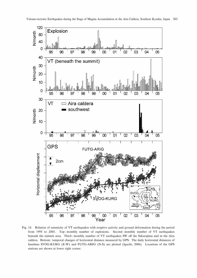
Fig. +.. Relation of seismicity of VT earthquakes with eruptive activity and ground deformation during the period
from +33/ to ,**/. Top : monthly number of explosions. Second : monthly number of VT earthquakes
beneath the summit area. Third : monthly number of VT earthquakes SW o# the Sakurajima and in the Aira
caldera. Bottom: temporal changes of horizontal distance measured by GPS. The daily horizontal distances of
baselines SVOG-KURG (E-W) and FUTG-ARIG (N-S) are plotted (Iguchi, ,**0). Locations of the GPS
stations are shown at lower right corner.
Volcano-tectonic Earthquakes during the Stage of Magma Accumulation at the Aira Caldera, Southern Kyushu, Japan 303
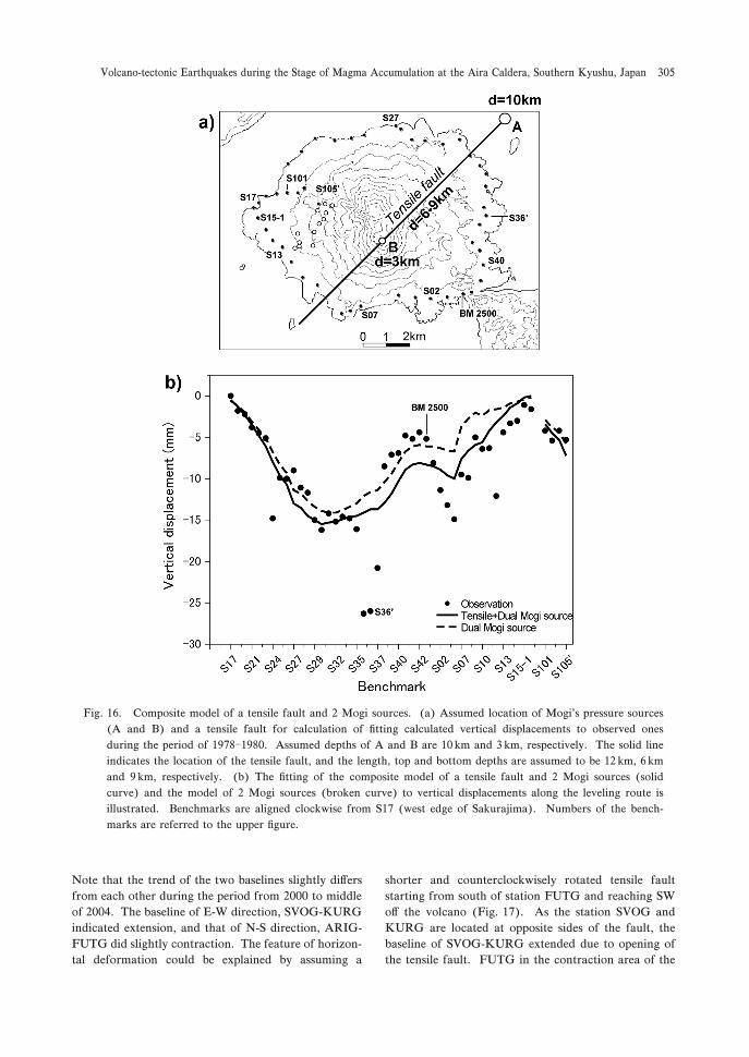
Eto and Nakamura (+320) explained ground defor-
mation around Sakurajima volcano by using the model
of , pressure sources based on Mogi’s model. However,
some of the observed data is not well fitted by the model,
in particular, in the periods +310�+312 and +312�+32*(Fig. 3 of Eto and Nakamura, +320). Here, we attempt
to explain the vertical displacement data during +312�+32* by a composite model of , Mogi sources and a
tensile fault, as illustrated in Fig. +0a. Two Mogi
sources “A” and “B” are assumed to be located at
depths of +* km and - km, respectively, based on calcu-
lation result by Eto and Nakamura (+320). The solid
line indicates the vertical tensile fault extending from
the main pressure source “A” beneath the caldera across
Sakurajima volcano “B” to the focal zone of VT earth-
quakes SW o#. The length of the tensile fault is +, km
and the depths of top and bottom of it are assumed to be
0 km and 3 km, respectively, considering the depth
range of VT earthquakes SW o#. Assuming this confi-
guration, other source parameters are estimated. Calcu-
lated vertical displacements based on the composite
model are compared with observed one along leveling
route (Fig. +0b). Calculation displacements are fairly
well fitted to observed data under the following condi-
tion ; volume decreases of the sources A and B: +.,�
+*1 m- and /.1�+*/ m-, respectively, opening of the
tensile fault : *.*0 m. Then, volume increase of the
tensile fault is estimated to be ,.+�+*0 m-. On most of
the benchmarks, calculated values based on the compos-
ite model are better fitted to observed vertical displace-
ment than those from the previous model of , Mogi
sources, except for around BM ,/** at SE edge of
Sakurajima. The model proposed in this study including
the tensile fault can explain the distribution of vertical
displacement better. The volume decrease of the sources
A and B and volume increase of the tensile fault is
balanced by volcanic ash and gas ejected from the summit
crater. During the period between the , measurements
of precise leveling, volcanic ash of +..�+*1 ton (/.0�+*0 m- DRE (dense rock equivalent) ; density is assumed
to be ,/** kg/m-) was ejected. It is di$cult to estimate
contribution of volcanic gas, however, it was reported
that volcanic gas was discharged at rates of +***�,***ton/day (Kamada et al., +32,)
Recent GPS data show change in the pattern of
ground deformation associated with VT earthquakes
SW o# the volcano, as illustrated in Fig. +.. Overall
features of change in horizontal distance along two GPS
baselines were quite similar, and basically reflect the
accumulation process of magma under the Aira caldera.
Fig. +/. Distributions of vertical ground displacements around Sakurajima volcano measured by precise leveling
during the periods : a) +31.�+310 (Eto and Ishihara, +32*), b) +310�+312 (Eto and Ishihara, +32*), c) +312�+32* (Eto et al., +32,) and d) +32*�+32, (Eto and Nakamura, +320). The displacement is referred to BM
,120.
Sri HIDAYATI, Kazuhiro ISHIHARA and Masato IGUCHI304
Note that the trend of the two baselines slightly di#ers
from each other during the period from ,*** to middle
of ,**.. The baseline of E-W direction, SVOG-KURG
indicated extension, and that of N-S direction, ARIG-
FUTG did slightly contraction. The feature of horizon-
tal deformation could be explained by assuming a
shorter and counterclockwisely rotated tensile fault
starting from south of station FUTG and reaching SW
o# the volcano (Fig. +1). As the station SVOG and
KURG are located at opposite sides of the fault, the
baseline of SVOG-KURG extended due to opening of
the tensile fault. FUTG in the contraction area of the
Fig. +0. Composite model of a tensile fault and , Mogi sources. (a) Assumed location of Mogi’s pressure sources
(A and B) and a tensile fault for calculation of fitting calculated vertical displacements to observed ones
during the period of +312�+32*. Assumed depths of A and B are +* km and - km, respectively. The solid line
indicates the location of the tensile fault, and the length, top and bottom depths are assumed to be +, km, 0 km
and 3 km, respectively. (b) The fitting of the composite model of a tensile fault and , Mogi sources (solid
curve) and the model of , Mogi sources (broken curve) to vertical displacements along the leveling route is
illustrated. Benchmarks are aligned clockwise from S+1 (west edge of Sakurajima). Numbers of the bench-
marks are referred to the upper figure.
Volcano-tectonic Earthquakes during the Stage of Magma Accumulation at the Aira Caldera, Southern Kyushu, Japan 305
tensile fault moved toward the edge of the tensile fault
(southward movement) and the station ARIG also
moved southward by opening of the tensile fault.
Therefore the baseline FUTG-ARIG showed no re-
markable change or slight contraction. The deflation
Mogi source in +312�+32* is located near Shinjima as
shown in Fig. +1 by “A”. Locations of the pressure
sources in inflation stage are estimated to be located a
little north or west of the deflation source. Circles “AL”
and “AG” in Fig. +1 indicate locations of the sources
during the period of +33+�+330 by precise leveling (Eto
et al., +332) and during the period of +331�+333 by
continuous GPS observation (Kriswati and Iguchi,
,**-). If the inflation source were located at di#erent
position from that of deflation source, it would be
reasonable that tensile crack occupies the northern part
of the Sakurajima rather than NE part. The model for
temporal changes of baselines measured by GPS corre-
sponds to less activity at the northern part of the tensile
fault as shown in Fig. +1. During the period from ,***to middle of ,**., remarkable inflation of the Aira
caldera was not detected.
Finally, the model proposed in the present study is
schematically illustrated in Fig. +2 comparing with the
model by Kamo (+323), and interpretation of recent
volcanic process is described according to the proposed
model.
+) Magma has been supplied to the main reservoir
beneath the Aira caldera, and the accumulation of
magma induces inflation at the caldera since +33-, as
indicated by leveling and GPS data (Figs. , and +.).
The location of pressure source is shown by “A”.
,) Magma started to intrude laterally toward the
Sakurajima volcano along the tensile fault, maybe, in
early +333, because the inflation of Aira caldera became
active in November +331 and the eruptive activity of
Sakurajima gradually increased in June +333 reaching at
a peak in December (Fig. +.). It is reasonable that
magma began to move from the magma reservoir be-
neath the Aira caldera to the Sakurajima before the
eruptive activity in late +333. As shown by changes of
pattern of baselines indicated by GPS from ,*** to the
middle of ,**., lateral movement to SW direction still
continued along the tensile fault in spite of less magma
accumulation beneath the Aira caldera.
-) As a result, VT earthquakes of normal fault type
were generated due to pressure increase at the south-
western edge of the tensile fault during the periods from
November ,**-�February ,**.. This lateral migration
might cause change in stress field at deeper parts around
the caldera. VT earthquakes at the caldera region might
be partly a#ected by adjustment of stress field due to this
intrusion process.
.) Due to the change of stress field of the Aira
caldera, some earthquakes occurred at NE of the Aira
caldera.
/) Accumulation of magma resumed beneath the
Aira caldera in October ,**..
During the periods from ,*** above mentioned, very
little magma moved to the magma chamber beneath the
summit. The pressure source “B” may be deflated as
discussed in 0�+.
1. Conclusions
VT earthquakes observed at Sakurajima volcano and
its surroundings during the period of +332-,**/ were
analyzed and discussed. The results are summarized as
follows ;
+) The seismicity is mainly found at three distinct
regions : beneath the summit, SW o# Sakurajima volca-
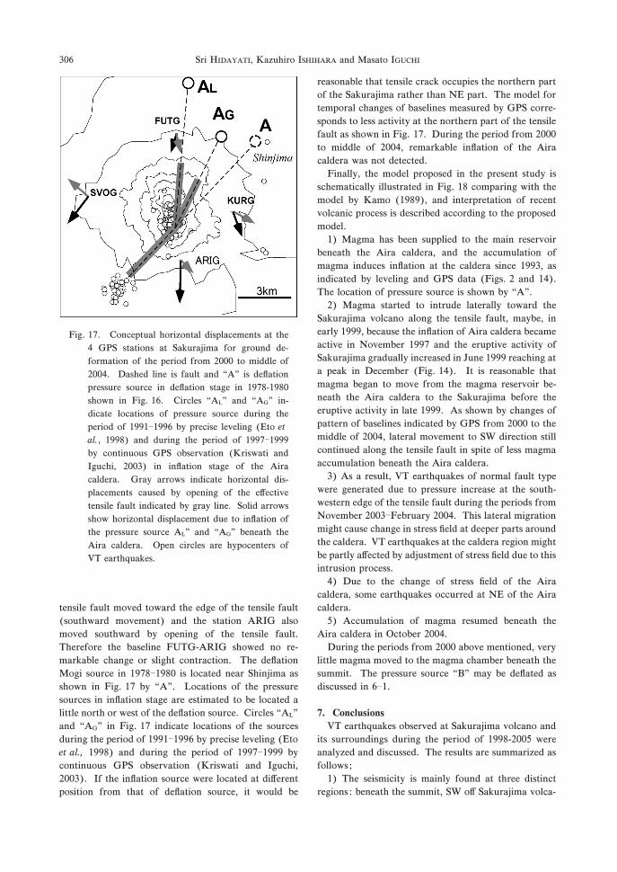
Fig. +1. Conceptual horizontal displacements at the
. GPS stations at Sakurajima for ground de-
formation of the period from ,*** to middle of
,**.. Dashed line is fault and “A” is deflation
pressure source in deflation stage in +312-+32*shown in Fig. +0. Circles “AL” and “AG” in-
dicate locations of pressure source during the
period of +33+�+330 by precise leveling (Eto et
al., +332) and during the period of +331�+333by continuous GPS observation (Kriswati and
Iguchi, ,**-) in inflation stage of the Aira
caldera. Gray arrows indicate horizontal dis-
placements caused by opening of the e#ective
tensile fault indicated by gray line. Solid arrows
show horizontal displacement due to inflation of
the pressure source AL” and “AG” beneath the
Aira caldera. Open circles are hypocenters of
VT earthquakes.
Sri HIDAYATI, Kazuhiro ISHIHARA and Masato IGUCHI306
no and NE part of the Aira caldera, in particular
around Wakamiko volcano. These regions are aligned
in NE-SW direction, which corresponds to active tec-
tonic zone.
,) Determined focal mechanism of VT earthquakes
beneath the summit region is reverse fault types in the
shallow portion�, km, meanwhile at deeper one, strike-
slip fault type is predominant. The di#erence in focal
mechanism above and below , km boundary seems to be
related to shape of the conduit at depths of , km and /km.
-) Most of VT earthquakes SW o# Sakurajima volca-
no indicated a unique focal mechanism of normal fault
type with horizontal T-axes oriented nearly to WNW-
ESE direction. At the NE part of the caldera, the
mechanism showed strike-slip fault types and one of the
nodal lines oriented in NE-SW. This orientation is
consistent with regional stress field and direction of
depression zone inferred from geological study.
.) The occurrence of VT earthquakes of normal fault
types at deep SW region could be explained by, for
example, a tensile fault, namely lateral dike, running
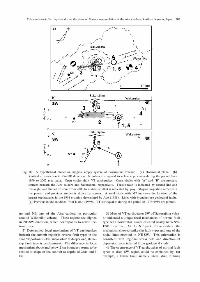
Fig. +2. A hypothetical model on magma supply system at Sakurajima volcano. (a) Horizontal plane. (b)
Vertical cross-section in SW-NE direction. Numbers correspond to volcanic processes during the period from
+333 to ,**/ (see text). Open circles show VT earthquakes. Open circles with “A” and “B” are pressure
sources beneath the Aira caldera and Sakurajima, respectively. Tensile fault is indicated by dashed line and
rectangle, and the active zone from ,*** to middle of ,**. is indicated by gray. Magma migration inferred in
the present and previous studies is shown by arrows. A solid circle with M1 indicates the location of the
largest earthquakes in the +3+. eruption determined by Abe (+32+). Lines with branches are geological faults.
(c) Previous model modified from Kamo (+323). VT earthquakes during the period of +310�+32* are plotted.
Volcano-tectonic Earthquakes during the Stage of Magma Accumulation at the Aira Caldera, Southern Kyushu, Japan 307
across the volcano from the main magma reservoir
beneath Aira caldera.
Acknowledgement
The authors are grateful to Drs T. Tameguri and K.
Yamamoto of SVRC, Disaster Prevention Research
Institute, Kyoto University and Profs Y. Tanaka, T.
Kagiyama, Y. Sudo and T. Ohkura of Aso Volcanolog-
ical Laboratory, Graduate School of Sciences for their
worthy comments and discussions. Thanks are extend-
ed to sta#s of SVRC for maintaining the instruments.
Finally, constructive reviews by Drs. H. Aoyama, J.
Oikawa and T. Tsutsui are very helpful.
References
Abe, K. (+32+) Seismometrical re-evaluation of the
Sakurajima Earthquake of January +,, +3+.. Geophys.
Bull. Hokaido Univ., -3, /1�0, (in Japanese with English
abstract).
Aki, K. and Richards, P.G. (+32*) Quantitative Seismolo-
gy. W.H. Freeman and Company, San Fransisco.
Aramaki, S. (+32.) Formation of the Aira caldera, South-
ern Kyushu,�,,,*** years ago. J. Geophys. Res, 23,
2.2/�2/*+.
Chouet, B.A. (+330) Long-period volcano seismicity : its
source and use in eruption forecasting. Nature, -2*, -*3�-+0.
De Natale, G., Petrazzuoli, S.M., Troise, C., Pingue, F. and
Capuano, P. (,***) Internal stress field at Mt. Vesuvius
as due to gravitational and structural e#ects : a model for
the generation of background seismicity at a central
volcano. J. Geophys. Res., +*/, +0,,*1�+0,,+..
Eto, T. (+301) Volcanic crustal deformation (III) : crustal
deformations in the vicinity of Aira caldera and the
activity of Sakurajima volcano. Bull. Volcanol. Soc. Japan,
+,, 2*�22 (in Japanese with English abstract).
Eto, T. and Ishihara, K. (+32*) Ground deformation
around Sakurajima volcano. In -rd Joint observation of
Sakurajima volcano (Kamo, K. ed), Sakurajima Volca-
nological Observatory, Kagoshima, +3�,+ (in Japanese).
Eto, T. and Nakamura, S. (+320) Ground deformation
around Sakurajima volcano�+31.�+32,�. In /th Joint
observation of Sakurajima volcano (Kamo, K. ed). Sakura-
jima Volcanological Observatory, Kagoshima, ++�,+ (in
Japanese).
Eto, T., Ishihara, K. and Nakamura, S. (+32,) Ground
deformation around Sakurajima volcano. In .th Joint
observation of Sakurajima volcano (Kamo, K. ed). Sakura-
jima Volcanological Observatory, Kagoshima, +3�,+ (in
Japanese).
Eto, T., Takayama, T., Yamamoto, K., Hendrasto, M.,
Miki, D., Sonoda, T., Kimata, F., Miyajima, R., Matsu-
shima, T., Uchida, K., Yakiwara, H. and Kobayashi, K.
(+332) On the result of leveling surveys around Sakura-
jima volcano during December +33+ to October +330. In
3th Joint observation of Sakurajima volcano (Ishihara, K.
ed). Sakurajima Volcano Research Center, Kagoshima,
+/�,3 (in Japanese).
Frazetta, G. and Villari, L. (+32+) The feeding of the
eruptive activity of Etna volcano. The regional stress
field as a constraint to magma uprising and eruption.
Bull. Volcanol., .., ,03�,2,.
Hashimoto, M. and Tada, T. (+322) Crustal deformations
before and after the +320 eruption of Izu-oshima volca-
no. Bull. Volcanol. Soc. Japan., --, S+-0�S+.. (in Japa-
nese with English abstract).
Hayasaka, S. (+321) Geologic structure of Kagoshima Bay,
South Kyushu, Japan. The Association for Geological
Collaboration in Japan. Monograph, --, ,,/�,-- (in
Japanese with English Abstract).
Hidayati, S., Iguchi, M., Ishihara, K., Purbawinata, M.A.,
Subandriyo, Sinulingga, I.K. and Suharna. (+332) A
preliminary result of quantitative evaluation on activity
of Merapi volcano. In Proc. on Symposium on Japan-
Indonesia IDNDR Project, +0/�+2*.
Iguchi, M. (+33.) A vertical expansion source model for
the mechanisms of earthquakes originated in the magma
conduit of an andesitic volcano : Sakurajima, Japan.
Bull. Volcanol. Soc. Japan, -3, .3�01.
Iguchi, M. (,**0) Aira caldera storing magma. Monthly
Chikyu, ,2, ++/�+,,.
Ishihara, K. (+322) Geophysical evidence on the existence
of magma reservoir and conduit at Sakurajima volcano,
Japan. Ann. Disast. Prev. Res. Inst., Kyoto Univ., -+B-+,
+�+/ (in Japanese with English abstract).
Ishihara, K. (+33*) Pressure sources and induced ground
deformation associated with explosive eruptions at andes-
itic volcano : Sakurajima volcano, Japan. In Magma
Transport and Storage (Ryan, M.P. ed), --/--/0. John
Wiley & Sons, Chischester.
Kamada, M., Ohta, K., Matsuwo, N. and Kimishima, K.
(+32,) Discharge of SO, from Mt. Minamidake of Sakura-
jima volcano. In .th Joint observation of Sakurajima
volcano (Kamo, K. ed). Sakurajima Volcanological Ob-
servatory, Kagoshima, 11�2* (in Japanese).
Kamo, K. (+312) Some phenomena before the summit
eruptions at Sakurajima volcano. Bull. Volcanol. Soc.
Japan, ,-, /-�0. (in Japanese with English abstract).
Kamo, K. (+323) A dialogue with Sakurajima volcano. In
Proc. Kagoshima International Conference on Volcanoes,
-�+-.
Kimura, M. (+32/) Back-arc rifting in the Okinawa Trough.
Mar and Petro. Geol., ,, ,,,�,.*.
Kisslinger, C. (+32*) Evaluation of S to P amplitude ratios
for determining focal mechanisms from regional network
observations. Bull. Seism. Soc. Am., 1*, 333�+*+..
Kriswati, E. and Iguchi, M. (,**-) Inflation of the Aira
caldera prior to the +333 eruptive activity at Sakurajima
volcano detected by GPS network in South Kyushu. Ann.
Disast. Prev. Res. Inst., Kyoto Univ., .0, 2+1�2,0.
Lahr, J.C. (+333) HYPOELLIPSE/Version +.* : a comput-
er program for determining local earthquake hypocentral
parameters, magnitude, and first-motion pattern (Y,K
Sri HIDAYATI, Kazuhiro ISHIHARA and Masato IGUCHI308
compliant version). US Geological Survey, Open-File
Report 2.�100, on-line edition.*
Latter, J. H. (+32+) Volcanic earthquakes and their rela-
tionship to eruptions at Ruapehu and Ngauruhoe vol-
canoes. J. Volcanol. Geotherm. Res., 3, ,3-�-*3.
Lay, T. and Wallace, T.C. (+33/) Modern Global Seismol-
ogy. Academic Press, California.
Minakami, T. (+31.) Seismology and volcanoes in Japan.
In Physical Volcanology (Civetta, L., Gasparini, P., Luongo,
G., Rapolla, A., eds), +�,1. Elsevier.
Mogi, K. (+3/2) Relations between the eruptions of vari-
ous volcanoes and the deformations of the ground sur-
faces around them. Bull. Earthq. Res. Inst., Univ. Tokyo,
-0, 33�+-..
Nishi, K. (+312) On the focal mechanism of volcanic
earthquakes in Sakurajima volcano. Ann. Disast. Prev.
Res. Inst., Kyoto Univ., ,+B-+, +./�+/, (in Japanese with
English abstract).
Nishi, K. (+32.) Volcanic B-type earthquake swarm pre-
ceding volcanic explosion. Ann. Disast. Prev. Res. Inst.,
Kyoto Univ., ,1B-+, ,3�-. (in Japanese with English ab-
stract).
Okada, Y. (+33,) Internal deformation due to shear and
tensile faults in half-space. Bull. Seism. Soc. Am., 1,, +*+2�+*.*.
Ratdomopurbo, A. (+33/) Etude sismoloique du vulcan
Merapi et formation du dome de +33.. PhD Thesis,
L’universite Joseph Fourier-Grenoble I, France.
Suantika, G., Iguchi, M., Sutawidjaya, I.S. and Yamamoto,
K. (+332) Characteristics of volcanic earthquakes around
Guntur volcano, West Java, Indonesia, hypocenter and
focal mechanism from +33.�+332. In Proc. on Symposi-
um on Japan-Indonesia IDNDR Project, Bandung, 1+�2*.
Tameguri, T., Iguchi, M. and Ishihara, K. (,**+) Reexam-
ination of moment tensors for initial motion of explosion
earthquakes using borehole seismograms at Sakurajima
volcano, Japan. Earth Planets Space, /-, 0-�02.
Umakoshi, K., Shimizu, H. and Matsuwo, N. (,**+)
Volcano-tectonic seismicity at Unzen volcano, Japan,
+32/�+333. J. Volcanol. Geotherm. Res., ++,, ++1�+-+.
Yamaoka, K., Watanabe, H. and Sakashita, S. (+322)
Seismicity during the +320 eruption of Izu-oshima volca-
no. Bull. Volcanol. Soc. Japan, --, S3+-S+*+ (in Japanese
with English abstract).
Yamasato, H. (+321) Distribution of the initial motions of
explosion earthquakes at Sakurajima volcano. Bull. Vol-
canol. Soc. Japan, -,, ,23�-** (in Japanese with English
abstract).
Yokoyama, I. (+320) Crustal deformation caused by the
+3+. eruption of Sakurajima volcano, Japan and its sec-
ular changes. J. Volcanol. Geotherm. Res., -*, ,2-�-*,.
Yokoyama, I. and Ohkawa, S. (+320) The subsurface struc-
ture of the Aira caldera and its vicinity in Southern
Kyushu, Japan. J. Volcanol. Geotherm. Res., -*, ,/-�,2,.
Yoshikawa, K. (+30+) On the result of the precise leveling
at Sakurajima (part ,) and the observations of the crustal
deformations at Sakurajima volcano (continued report).
Ann. Disast. Prev. Res. Inst., Kyoto Univ., .2, +�+/ (in
Japanese with English abstract).
(Editiorial handling Tomoki Tsutsui)
����������� ����������
S. Hidayati���������
�!"�#$%&'()��������*%+, -./ +33-012)3456�789:��������;<=>%?@ABC/D ,**-0 ++EFG:34HIJ� 0K3 km�LM9��%N;() OPQ5RS;<%TUGVWFC/������XYZ9[��%;<(/D \0] :GPS ^_������*�+,%`aMV/%34�"�#$ bcWde:fVB9�5fgTUGVhiWiD +332K,**/0 ;<(/���������j5;�k�lmU)��#$�^n��opq5�rsltu(/D v+w 34�^n6�78����������j:������FG34lxCh6�HIy F�hz{() fVG:) 34H|}'�LM *K. km) HIJLM 0K3km�^n������~LM .K+. km
� -���� z�GV�D H|'�LM , kmB9�;�k�:����%����%) , km^_LiZz9:��V�%����D v,w 34HIJ��������:,��%IXI�YHY�������9�_) v-w ������~��������������:������ ��(h�_) i�V[f�����������5���9��D v.w 34HIJ���#$%������FG34l������� ¡¢£� r¤(hi��9:WiF5i¥¦§ /Ch) �¨d$�©ªl«¬(h6�®�ltu��55[ ) ¯/W��opq°��l±²(/D
* http ://jclahr.com/science/software/hypoellipse/
Volcano-tectonic Earthquakes during the Stage of Magma Accumulation at the Aira Caldera, Southern Kyushu, Japan 309