Embed Size (px)
Citation preview
Weather and Climate Modelling Efforts at
MoES
M RajeevanMinistry of Earth Sciences
New Delhi
Major Weather and Climate Prediction Activities
• IMD is supported by NCMRWF and IITM Pune for modelling activities.• Short to medium range prediction
• Extended Range Prediction
• Seasonal Forecasts
• Modelling of Water Cycle
• Fog Prediction efforts
• Air Pollution Emergencies
• Two modelling frameworks are being used:• NCEP GFS and CFS models
• UK Met Office Unified Models
• Seamless prediction

Models being used for operational work at MoES• Short to Medium Range
• GFS Model T1534 (12 Km) – Deterministic• GFS Model T 574 - Ensemble (20 Members)• UKMO UM N768 (17 Km) Deterministic• UKMO UM N400 (33 Km) Ensemble – 44 Members• UKMO UM Regional Model- 4 km
• Extended Range • CFS/GFS Model T126 – Original and bias corrected • CFS/GFS Model T382 - Original and bias corrected
• Seasonal Forecasts• CFS Model T382- 40 Ensembles
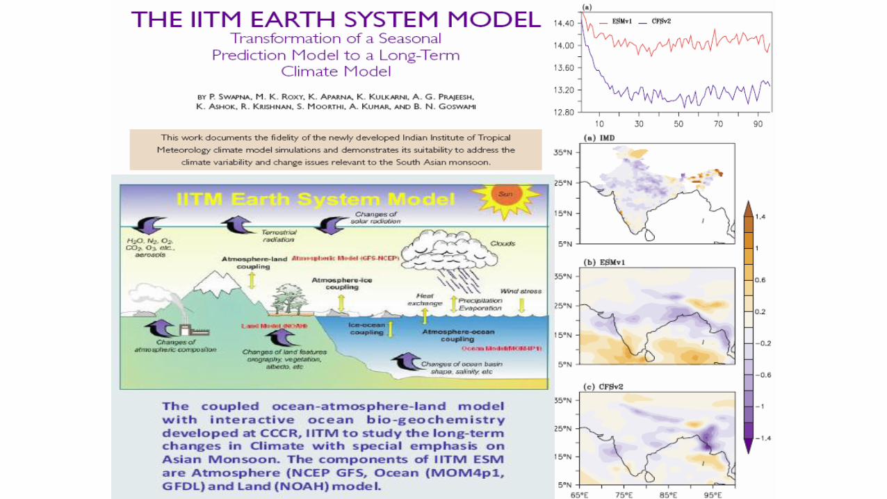
• Climate Change Projections- Earth System Model• CFS Model -T62
44 Members
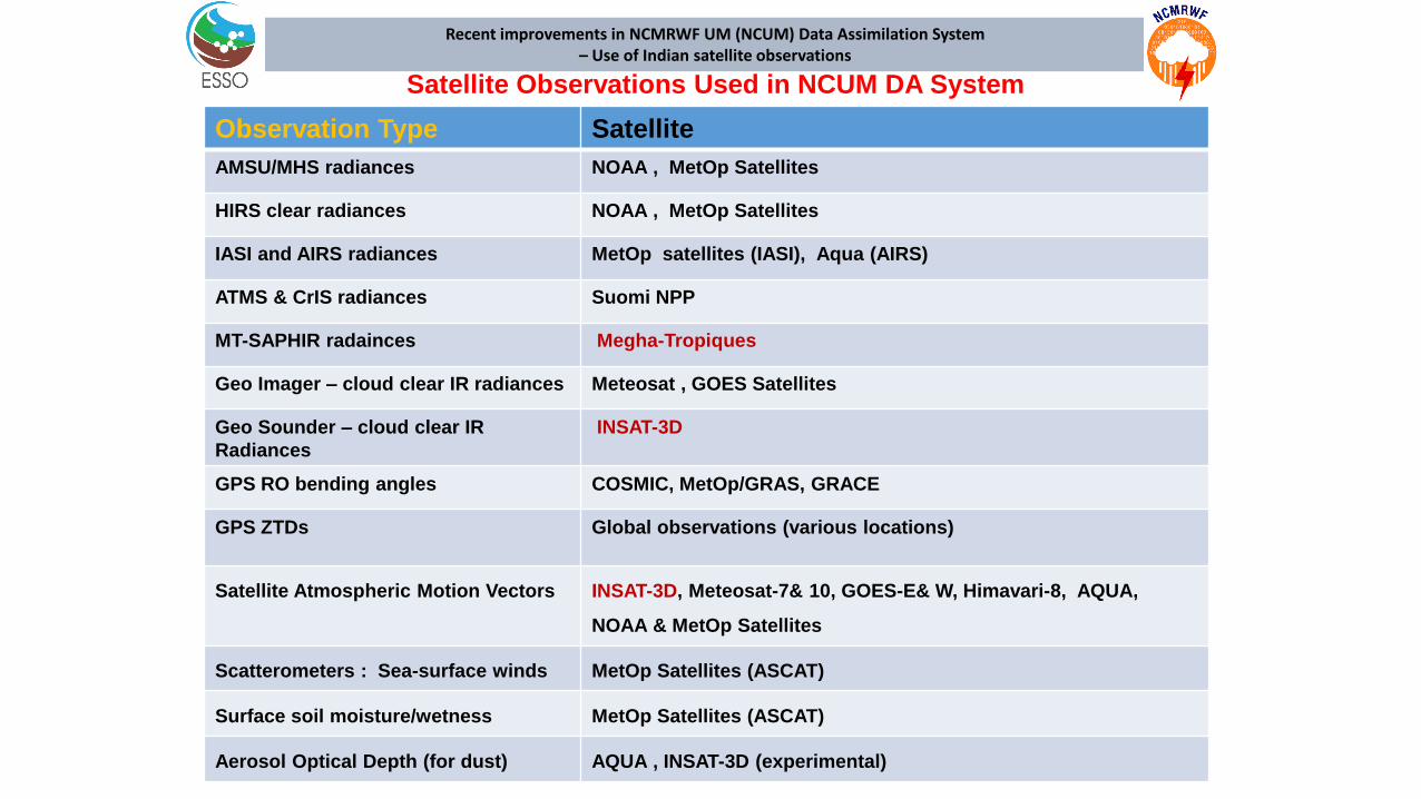
Observation Type Satellite
AMSU/MHS radiances NOAA , MetOp Satellites
HIRS clear radiances NOAA , MetOp Satellites
IASI and AIRS radiances MetOp satellites (IASI), Aqua (AIRS)
ATMS & CrIS radiances Suomi NPP
MT-SAPHIR radainces Megha-Tropiques
Geo Imager – cloud clear IR radiances Meteosat , GOES Satellites
Geo Sounder – cloud clear IR
Radiances
INSAT-3D
GPS RO bending angles COSMIC, MetOp/GRAS, GRACE
GPS ZTDs Global observations (various locations)
Satellite Atmospheric Motion Vectors INSAT-3D, Meteosat-7& 10, GOES-E& W, Himavari-8, AQUA,
NOAA & MetOp Satellites
Scatterometers : Sea-surface winds MetOp Satellites (ASCAT)
Surface soil moisture/wetness MetOp Satellites (ASCAT)
Aerosol Optical Depth (for dust) AQUA , INSAT-3D (experimental)
Satellite Observations Used in NCUM DA System
Recent improvements in NCMRWF UM (NCUM) Data Assimilation System – Use of Indian satellite observations
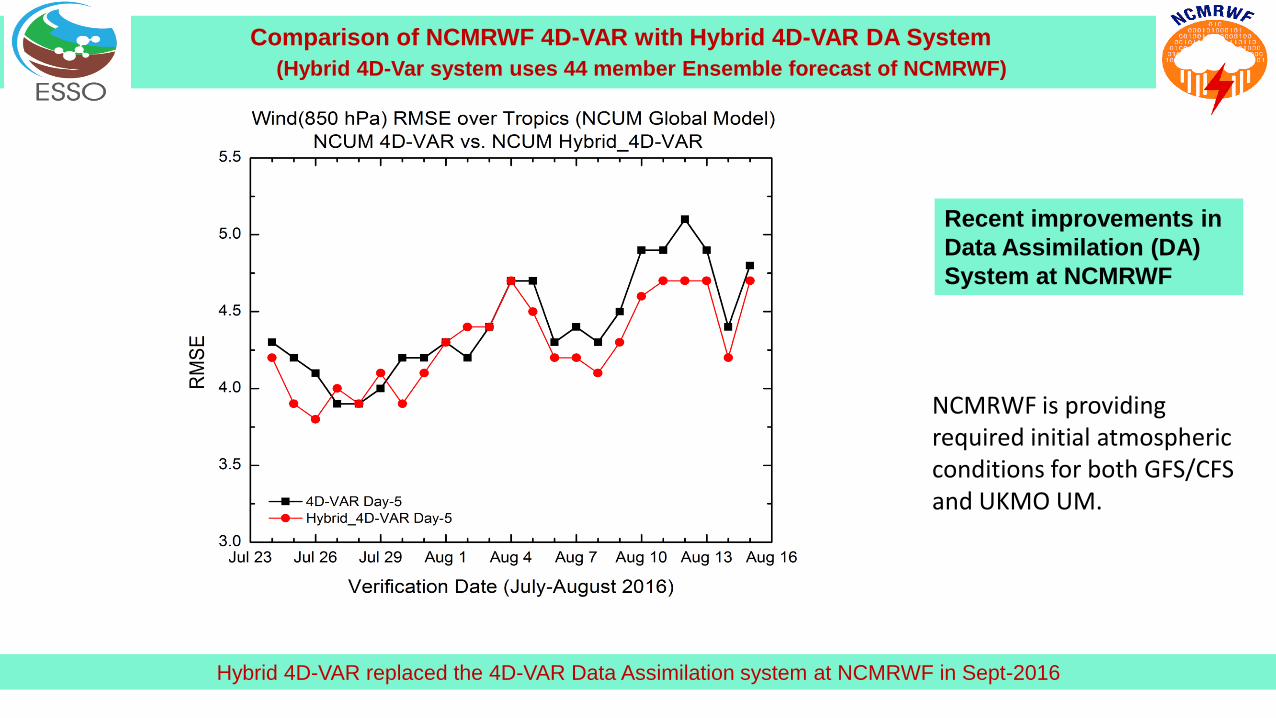
Comparison of NCMRWF 4D-VAR with Hybrid 4D-VAR DA System
(Hybrid 4D-Var system uses 44 member Ensemble forecast of NCMRWF)
Hybrid 4D-VAR replaced the 4D-VAR Data Assimilation system at NCMRWF in Sept-2016
Recent improvements in
Data Assimilation (DA)
System at NCMRWF
NCMRWF is providing required initial atmospheric conditions for both GFS/CFS and UKMO UM.

Radar Data Assimilation in 4 km NCUM Regional ModelVerification of Rainfall forecast
Number of DWR radial wind observations used in DAfrom each radar is given in the brackets
Rainfall Observation
(IMD-NCMRWF)
24 hr forecast:
DA with GTS+Satelite Obs
24 hr forecast: DA with
GTS+Satellite+Radar DWR wind observations used in DA
Rainfall valid at 00 UTC 27-July-2016
(24 hr forecast based on 00 UTC 26-July-2016 initial condition)
DWR Radial Wind Assimilation in Regional NCUM DA system
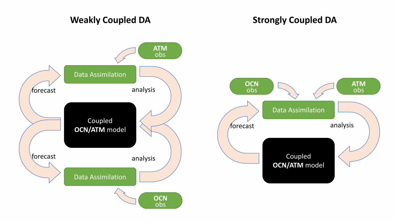
Coupled OCN/ATM model
Data Assimilation
Data Assimilation
analysis
analysisforecast
forecast
ATM obs
OCN obs
Coupled OCN/ATM model
Data Assimilation
analysisforecast
ATM obs
OCN obs
Weakly Coupled DA Strongly Coupled DA
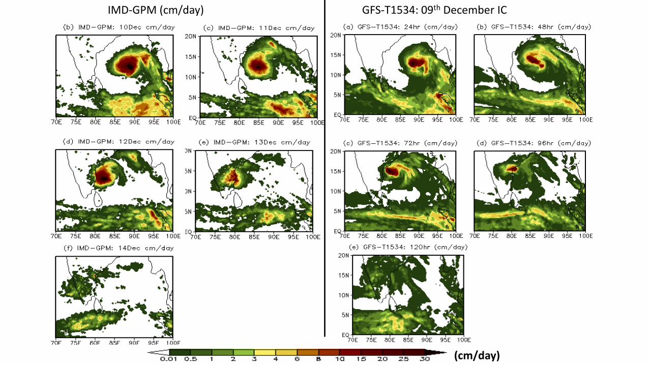
IMD-GPM (cm/day) GFS-T1534: 09th December IC
(cm/day)
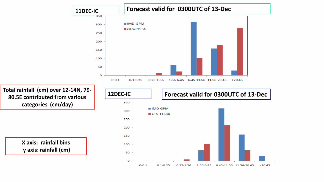
Forecast valid for 0300UTC of 13-Dec11DEC-IC
12DEC-IC Forecast valid for 0300UTC of 13-DecTotal rainfall (cm) over 12-14N, 79-
80.5E contributed from various categories (cm/day)
X axis: rainfall binsy axis: rainfall (cm)
Based on 10 Dec IC
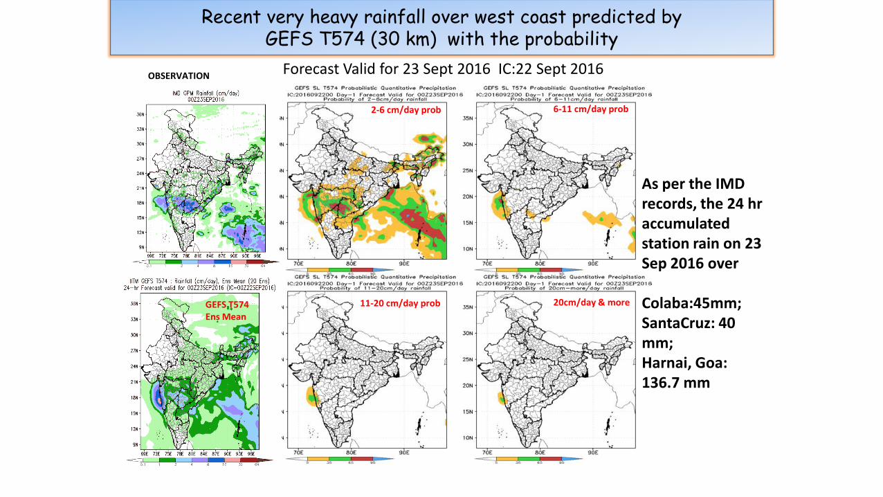
Recent very heavy rainfall over west coast predicted by GEFS T574 (30 km) with the probability
Forecast Valid for 23 Sept 2016 IC:22 Sept 2016
20cm/day & more11-20 cm/day prob
6-11 cm/day prob2-6 cm/day prob
OBSERVATION
As per the IMD records, the 24 hr accumulated station rain on 23 Sep 2016 over
Colaba:45mm; SantaCruz: 40 mm; Harnai, Goa: 136.7 mm
GEFS T574 Ens Mean

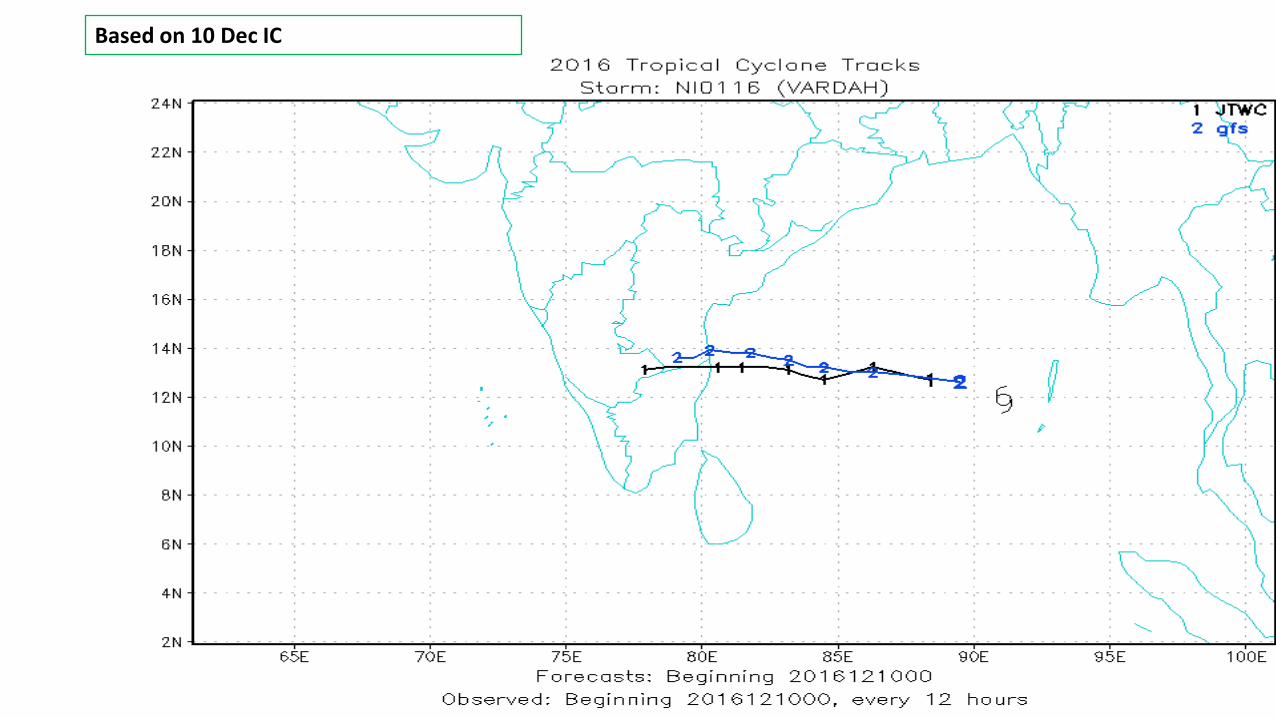
Probabilistic Prediction of Heavy rain over Chennai associated with Cyclone VERDAH 12 Dec 2016
Forecast valid for 00Z13Dec2016 IC: 00Z12Dec2016


Extended Range Forecasts
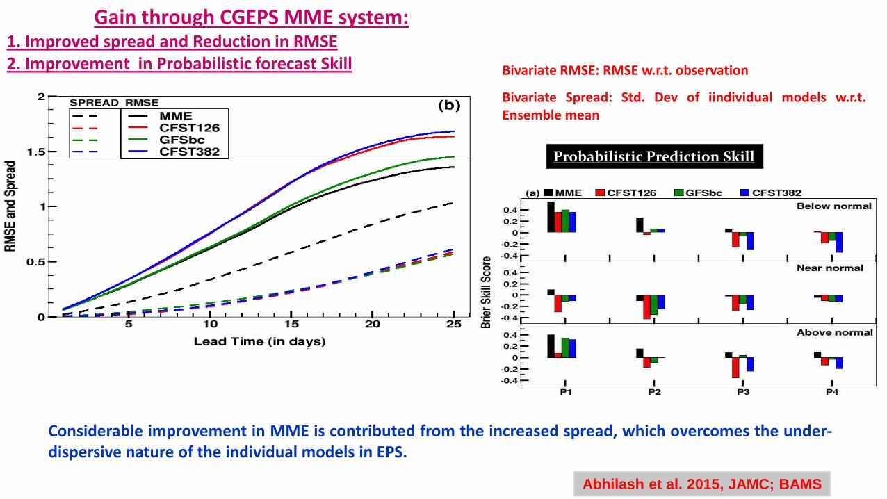
Gain through CGEPS MME system:1. Improved spread and Reduction in RMSE2. Improvement in Probabilistic forecast Skill
Considerable improvement in MME is contributed from the increased spread, which overcomes the under-dispersive nature of the individual models in EPS.
Abhilash et al. 2015, JAMC; BAMS
Bivariate RMSE: RMSE w.r.t. observation
Bivariate Spread: Std. Dev of iindividual models w.r.t.Ensemble mean
Probabilistic Prediction Skill

MOK date has been calculatedfor all 44 members of CGEPSand the mean of all of them isgiven as the final predictedMOK date.
Prediction of MOK during 2015 monsoon
IC: 16 May
MME
OBS

Prediction of Heavy Rainfall Events Uttarakhand event in June 2013 (IC:
0605)
OBS
MME
MMEOBS
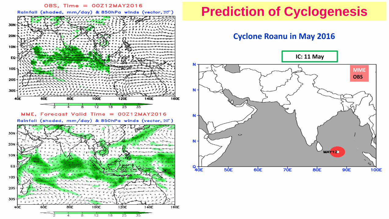
IC: 11 May
Cyclone Roanu in May 2016
Prediction of Cyclogenesis
OBS model
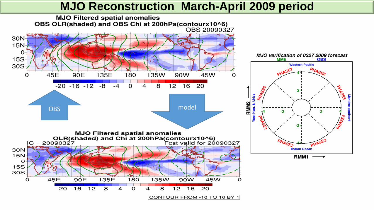
MJO Reconstruction March-April 2009 period
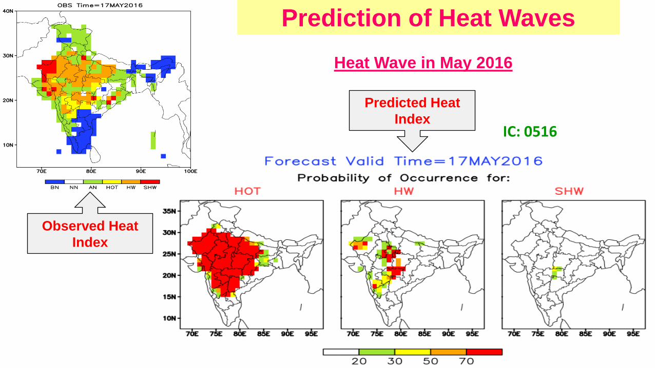
Heat Wave in May 2016
Observed Heat
Index
Predicted Heat
IndexIC: 0516
Prediction of Heat Waves

Seasonal Forecasts
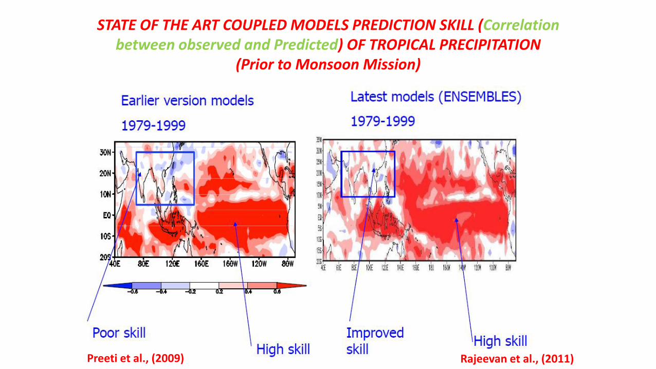
Rajeevan et al., (2011)Preeti et al., (2009)
STATE OF THE ART COUPLED MODELS PREDICTION SKILL (Correlation between observed and Predicted) OF TROPICAL PRECIPITATION
(Prior to Monsoon Mission)

IITM CFS Model:
Seasonal Prediction
Ocean Model
MOMv4
global
1/2ox1/2o (1/4o in tropics)
40 levels
Atmospheric Model
GFS
T382 L64 levels
Land Model
NOAH
Ice Model
COUPLER
ATMOSPHERE INITIAL CONDITIONS FROM GSI
(NCMRWF)
OCEAN INITIAL CONDITIONS FROM GODAS(INCOIS/IITM)
(Original model is adopted from NCEP)
Initial conditions for Hindcast runs are obtained from CFSR

Feb. IC
Apr.IC
Anomaly Correlation Between Observed and Predicted (Rain: 1982-2008)
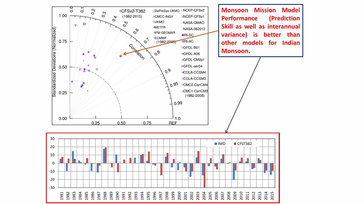
Monsoon Mission ModelPerformance (PredictionSkill as well as interannualvariance) is better thanother models for IndianMonsoon.
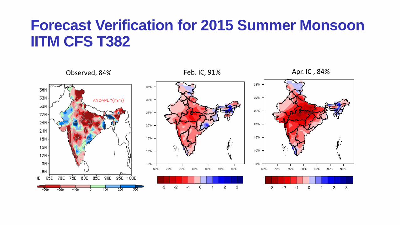
Forecast Verification for 2015 Summer MonsoonIITM CFS T382
Observed, 84% Feb. IC, 91% Apr. IC , 84%
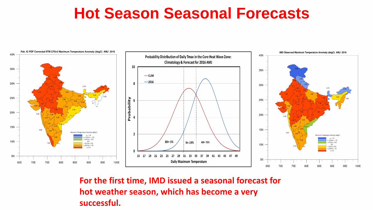
Hot Season Seasonal Forecasts
For the first time, IMD issued a seasonal forecast for hot weather season, which has become a very successful.
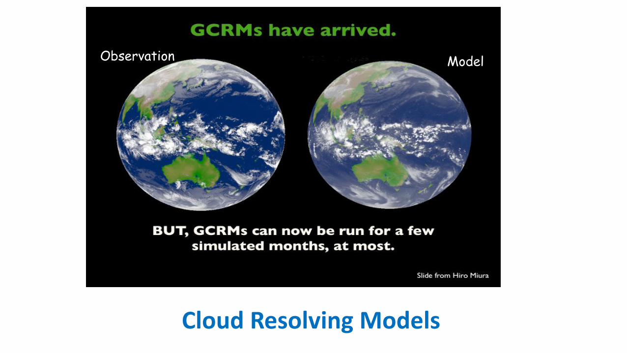
Scientific Basis of high resolution global modelModelObservation
Cloud Resolving Models

Superparameterized CFSv2-T62 (SPCFS) Analyses of 6.5 year free run
Convective tendencies are explicitly simulated with a Cloud Resolving Model running in each GCM grid column
which replaces the traditional cumulus parameterization of the GCM.
• Model integrated for 6.5 years and five years are analyzed
Bidyut B. Goswami, R. P. M. Krishna, P. Mukhopadhyay, Marat Khairoutdinov, andB. N. Goswami, 2015: Simulation of the Indian Summer Monsoon in theSuperparameterized Climate Forecast System Version 2: Preliminary Results. J.Climate, 28, 8988–9012
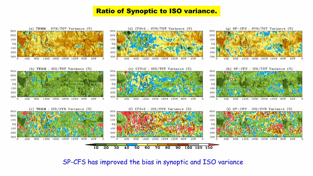
Ratio of Synoptic to ISO variance.
SP-CFS has improved the bias in synoptic and ISO variance
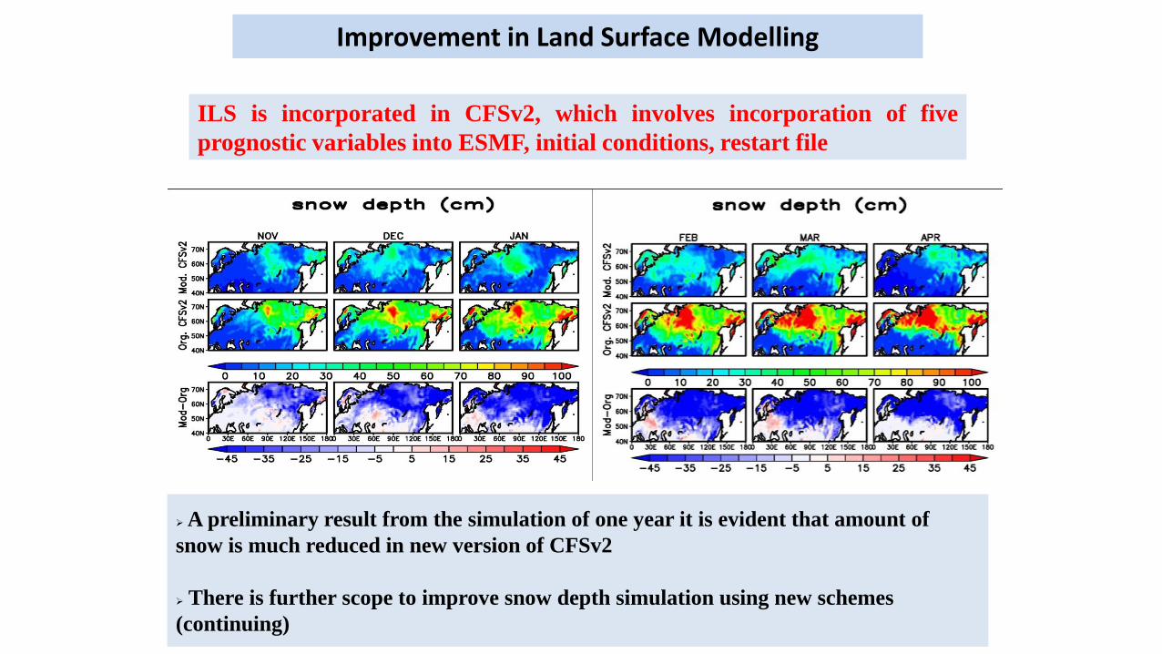
Improvement in Land Surface Modelling
ILS is incorporated in CFSv2, which involves incorporation of five
prognostic variables into ESMF, initial conditions, restart file
A preliminary result from the simulation of one year it is evident that amount of
snow is much reduced in new version of CFSv2
There is further scope to improve snow depth simulation using new schemes
(continuing)
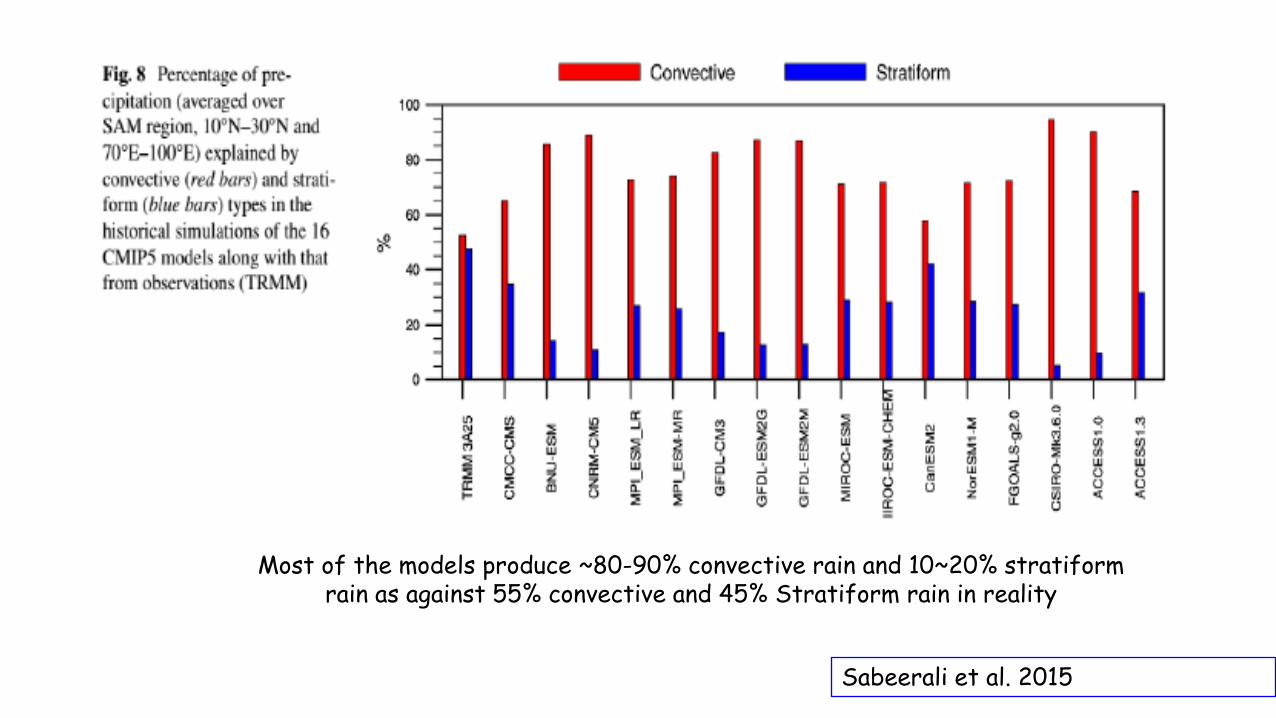
Sabeerali et al. 2015
Most of the models produce ~80-90% convective rain and 10~20% stratiformrain as against 55% convective and 45% Stratiform rain in reality
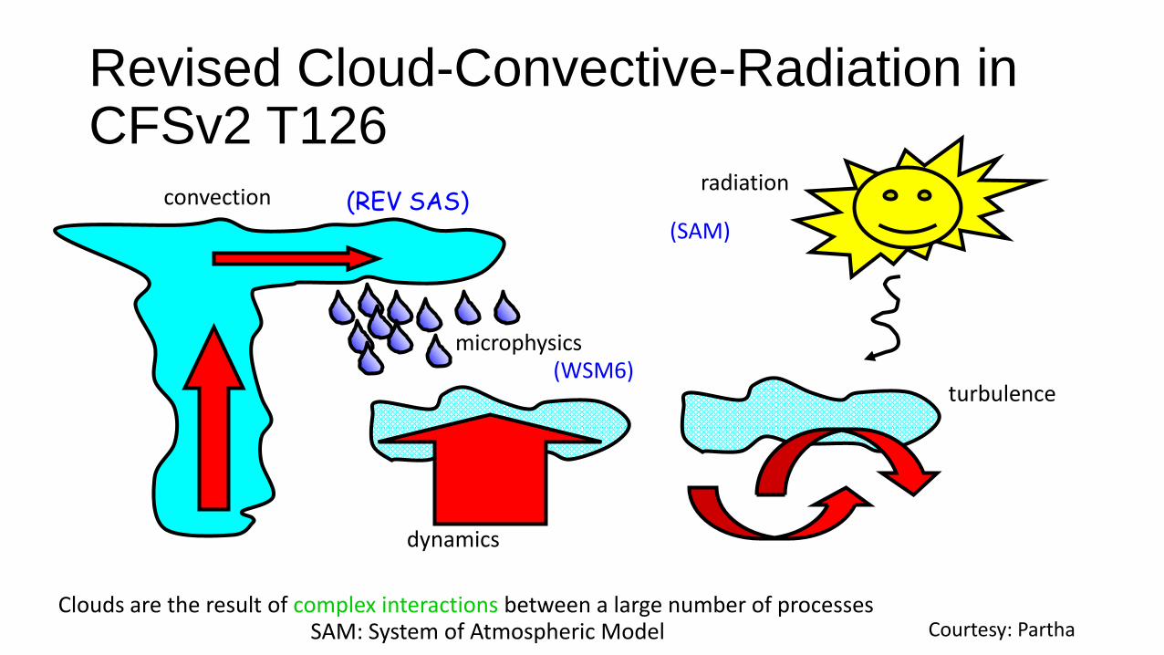
Revised Cloud-Convective-Radiation in CFSv2 T126
convection
Clouds are the result of complex interactions between a large number of processes
radiation
turbulence
dynamics
microphysics
(REV SAS)
(WSM6)
(SAM)
SAM: System of Atmospheric Model Courtesy: Partha
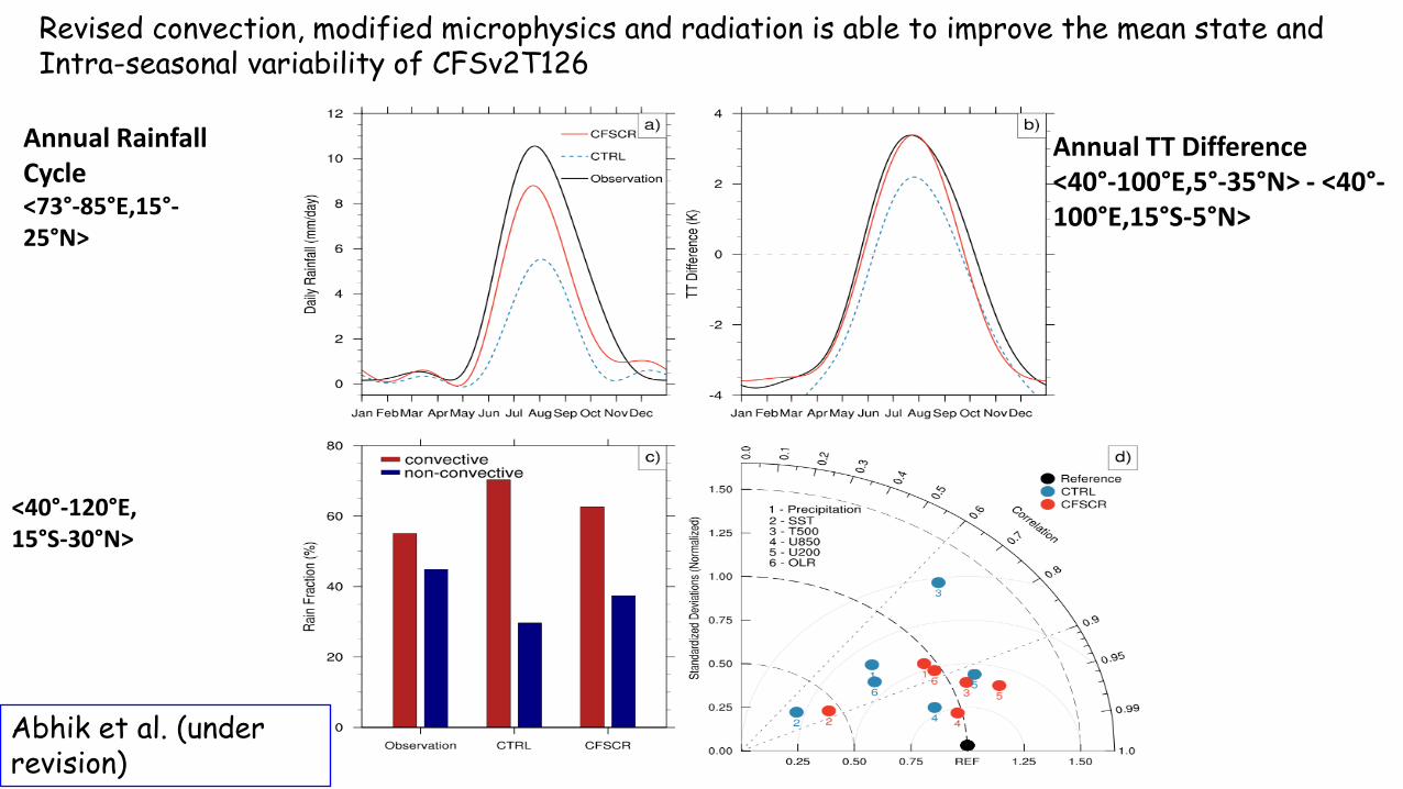
Annual Rainfall Cycle<73°-85°E,15°-25°N>
Annual TT Difference<40°-100°E,5°-35°N> - <40°-100°E,15°S-5°N>
<40°-120°E,15°S-30°N>
Revised convection, modified microphysics and radiation is able to improve the mean state and Intra-seasonal variability of CFSv2T126
Abhik et al. (under revision)
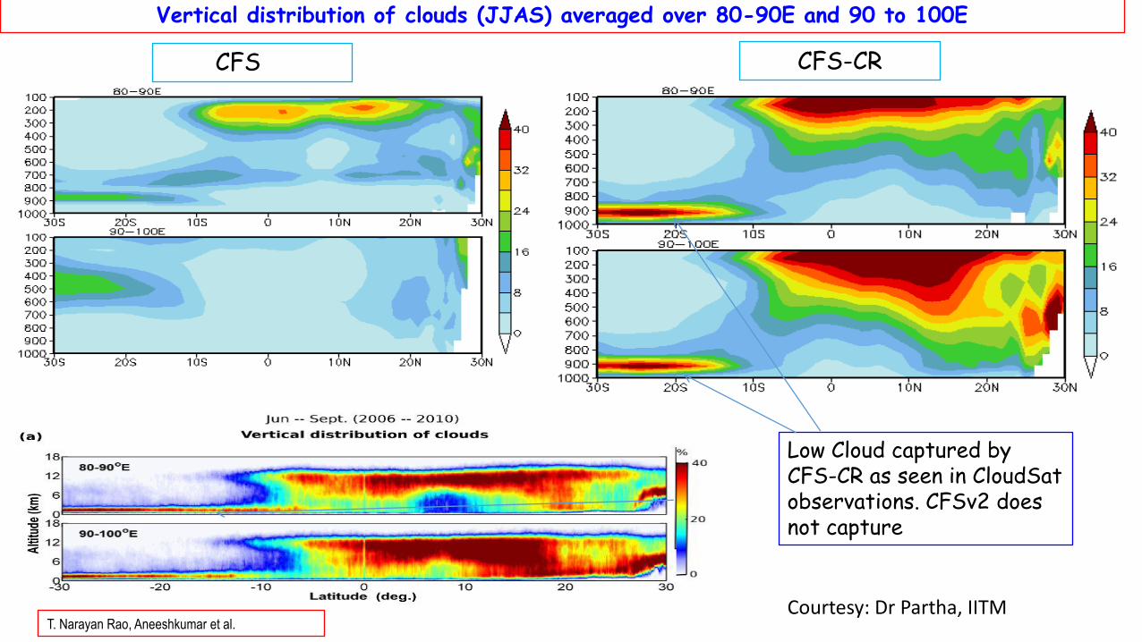
Vertical distribution of clouds (JJAS) averaged over 80-90E and 90 to 100E
CFS-CRCFS
Low Cloud captured by CFS-CR as seen in CloudSatobservations. CFSv2 does not capture
T. Narayan Rao, Aneeshkumar et al.Courtesy: Dr Partha, IITM
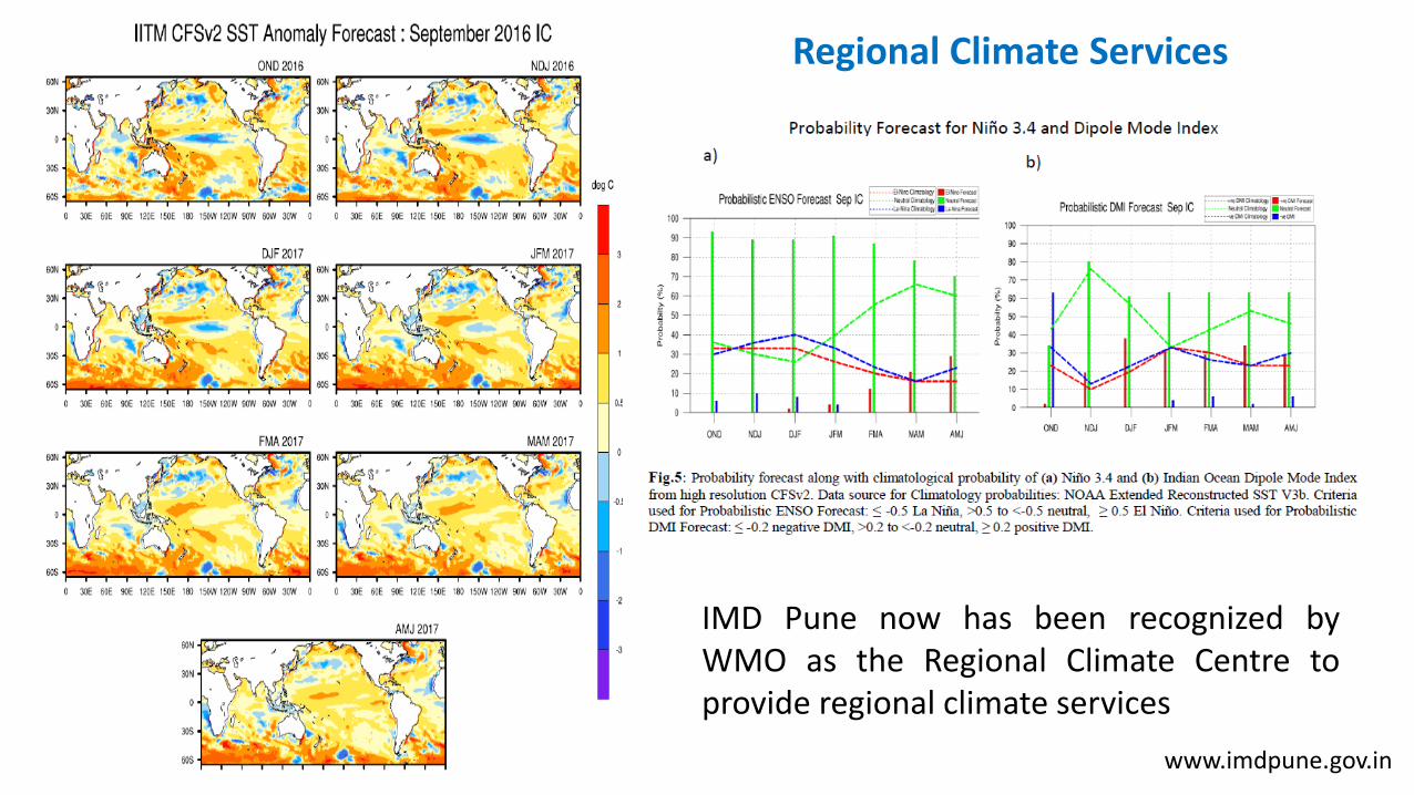
Regional Climate Services
IMD Pune now has been recognized byWMO as the Regional Climate Centre toprovide regional climate services
www.imdpune.gov.in

Climate Change Modelling
41
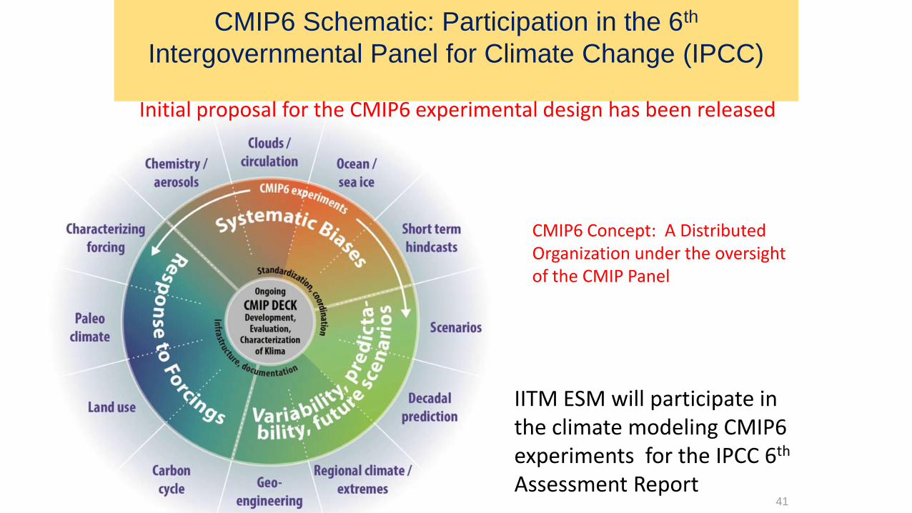
CMIP6 Concept: A Distributed Organization under the oversight of the CMIP Panel
CMIP6 Schematic: Participation in the 6th
Intergovernmental Panel for Climate Change (IPCC)
Initial proposal for the CMIP6 experimental design has been released
IITM ESM will participate in the climate modeling CMIP6 experiments for the IPCC 6th
Assessment Report
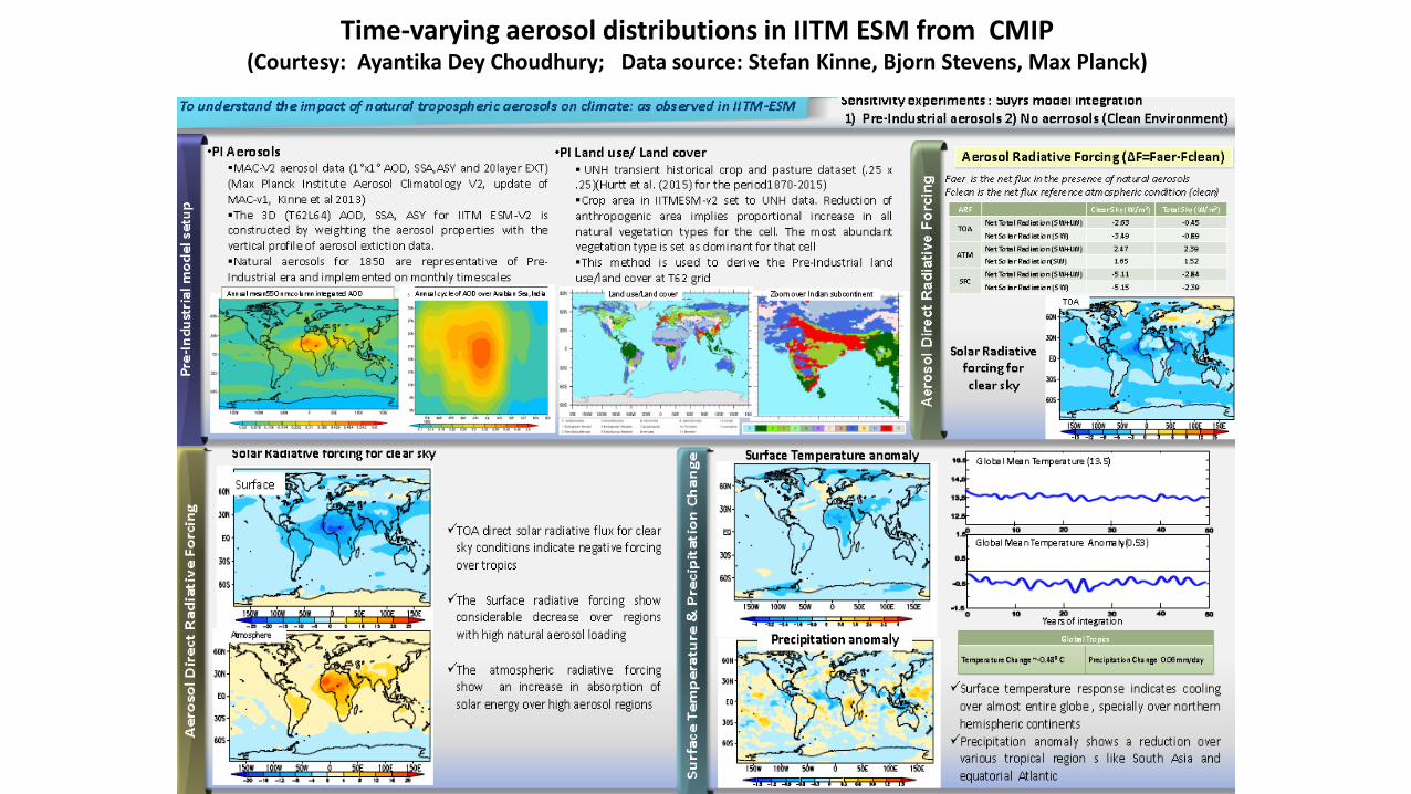
Time-varying aerosol distributions in IITM ESM from CMIP(Courtesy: Ayantika Dey Choudhury; Data source: Stefan Kinne, Bjorn Stevens, Max Planck)
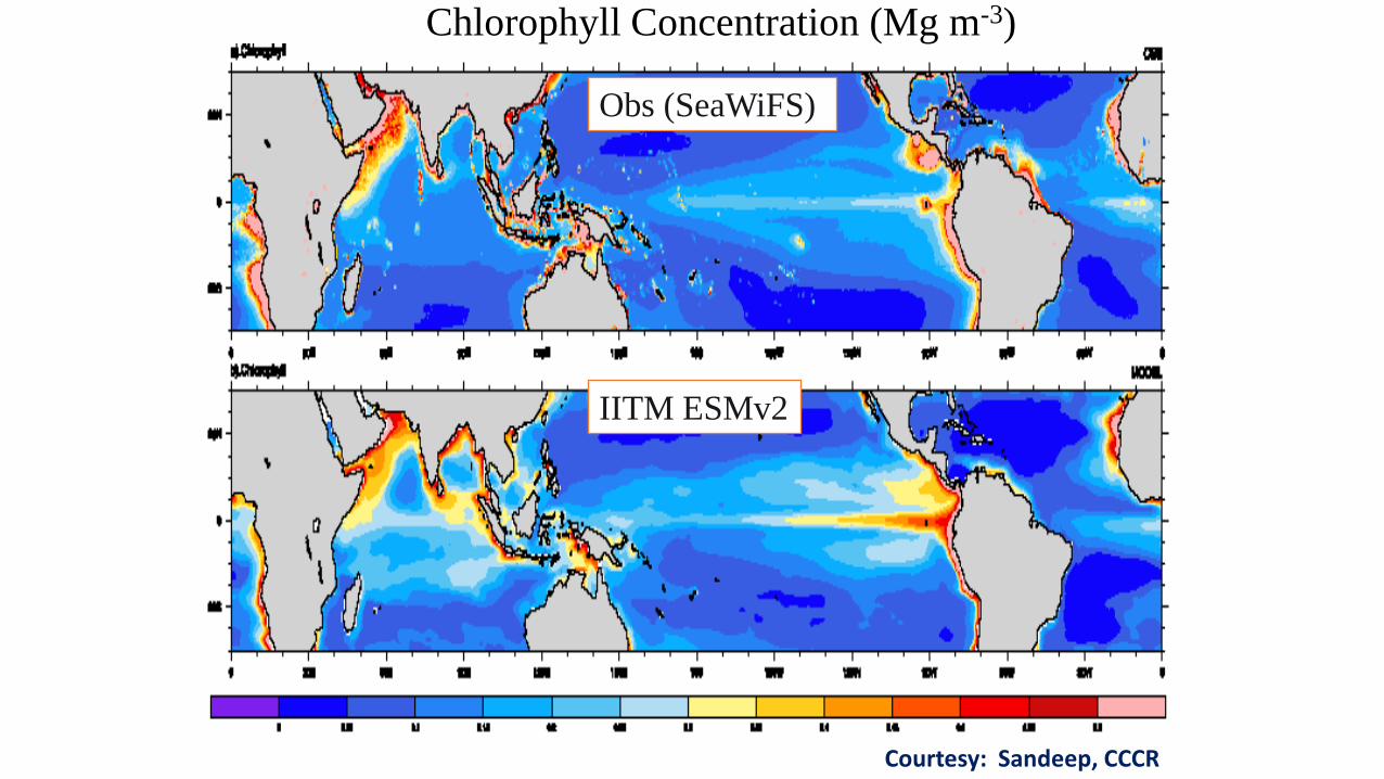
Chlorophyll Concentration (Mg m-3)
IITM ESMv2
Obs (SeaWiFS)
Courtesy: Sandeep, CCCR
Boreal summer monsoon (JJAS) precipitation (mm day-1)
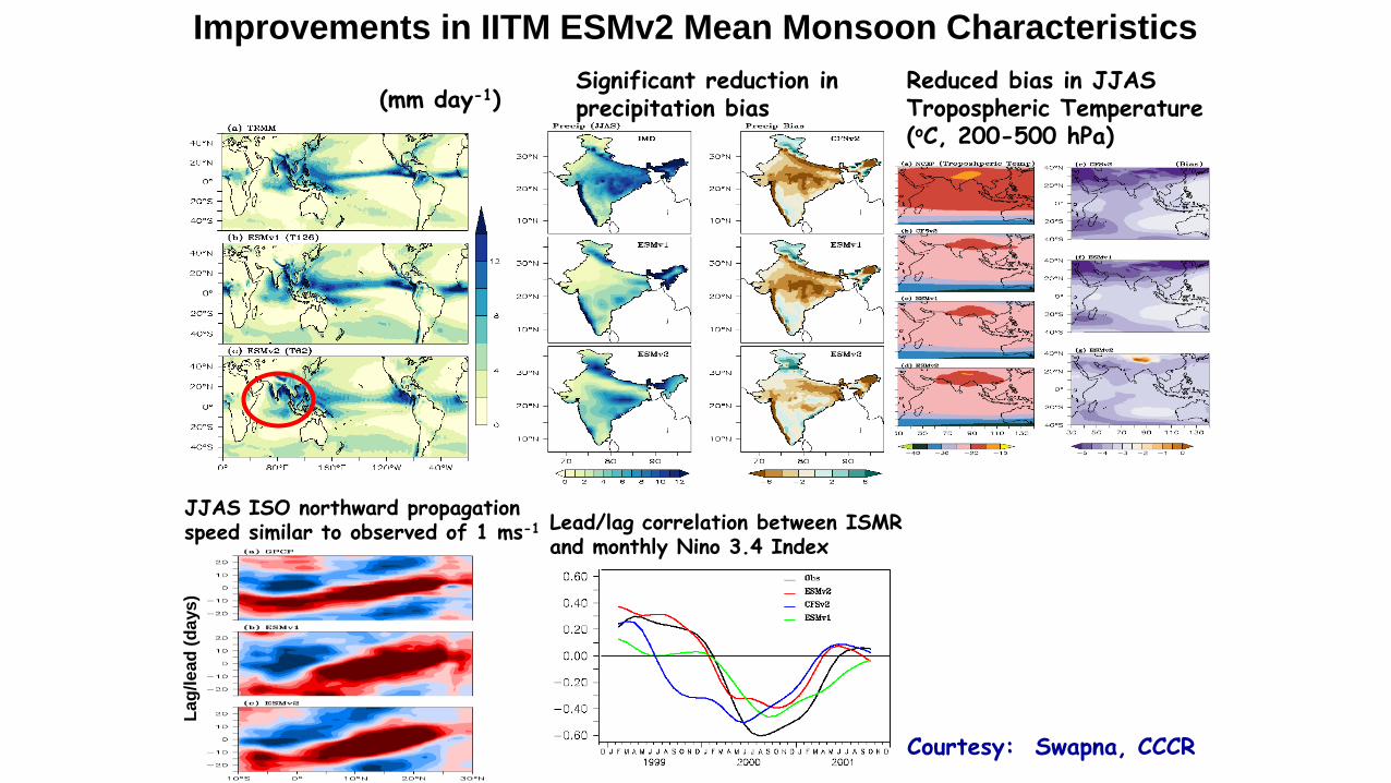
Improvements in IITM ESMv2 Mean Monsoon Characteristics
Significant reduction in precipitation bias
Reduced bias in JJAS Tropospheric Temperature (oC, 200-500 hPa)
JJAS ISO northward propagation speed similar to observed of 1 ms-1
La
g/l
ea
d (
da
ys
)
Lead/lag correlation between ISMR and monthly Nino 3.4 Index
Courtesy: Swapna, CCCR
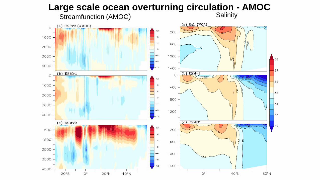
Large scale ocean overturning circulation - AMOC
CMIP6
Model
Streamfunction (AMOC) Salinity

CORDEX South Asia Co-ordination @ CCCR, IITM, Pune
• Development of multi-model ensemble projections of highresolution (50km) regional climate change scenarios for SouthAsia
• Generation of regional climate projections at CCCR-IITM
• LMDZ variable grid global climate model
• RegCM4 regional climate model
• Co-ordination with partner institutions for multi-model
ensemble projections – SMHI, IAES, CSC, CSIRO, ICTP…
• Development of an Earth System Grid (ESG) node at
CCCR-IITM for CORDEX South Asia
• Archival, Management, Dissemination of CORDEX South Asia data
• Evaluation of regional climate projections over South Asia
• For reliable regional climate change information for effectiveharnessing of science-based climate information by Vulnerability,Impact Adaptation (VIA) community
• Development of regional capacity for assessment of regionalclimate change
Coordinated Regional Climate Downscaling Experiment (CORDEX):Sponsored by the World Climate Research Programme , WMO
The CORDEX vision is to advance and coordinate the science andapplication of regional climate downscaling through global partnerships
ESG Data Node @ CCCR, IITMhttp://esg-cccr.tropmet.res.in/esgf-web-fe/


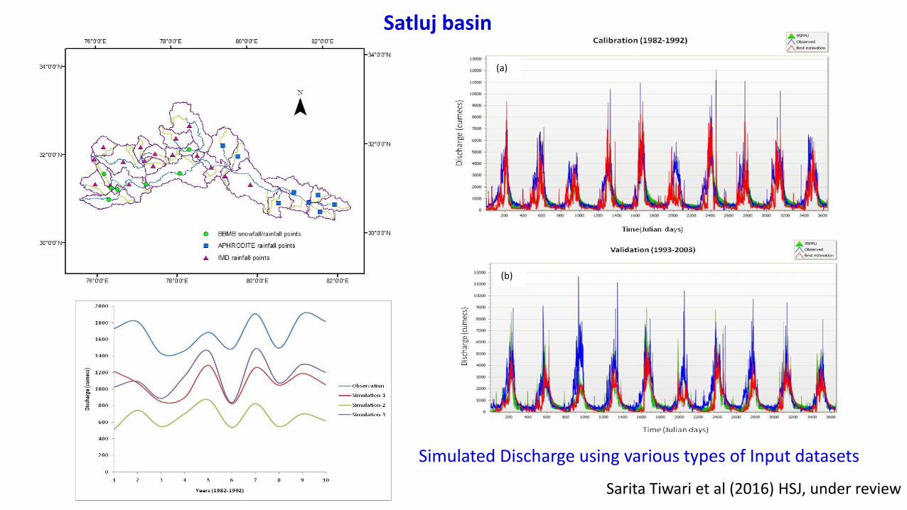
Modelling of Water Cycle
(a)
(b)
Simulated Discharge using various types of Input datasets
Satluj basin
Sarita Tiwari et al (2016) HSJ, under review

Prediction of Fog
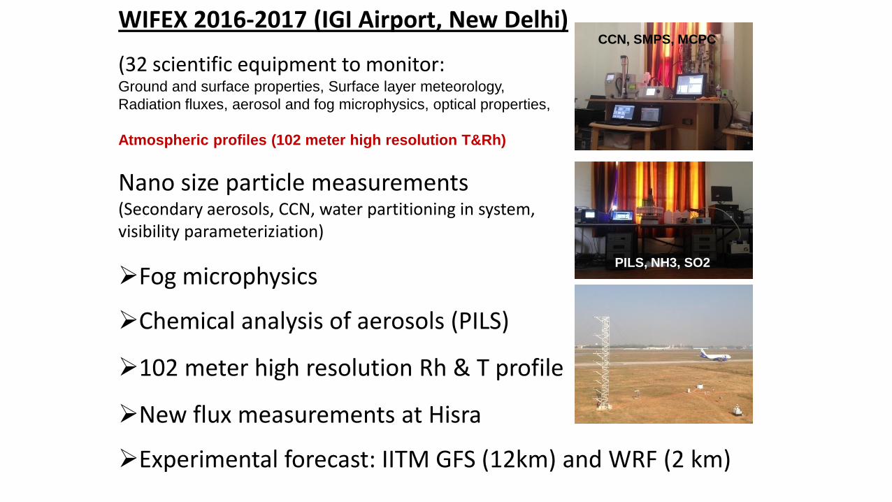
WIFEX 2016-2017 (IGI Airport, New Delhi)
(32 scientific equipment to monitor:Ground and surface properties, Surface layer meteorology,
Radiation fluxes, aerosol and fog microphysics, optical properties,
Atmospheric profiles (102 meter high resolution T&Rh)
Nano size particle measurements(Secondary aerosols, CCN, water partitioning in system,visibility parameteriziation)
Fog microphysics
Chemical analysis of aerosols (PILS)
102 meter high resolution Rh & T profile
New flux measurements at Hisra
Experimental forecast: IITM GFS (12km) and WRF (2 km)
CCN, SMPS, MCPC
PILS, NH3, SO2

Flux Tower
Ramdas Layer Celiometer CDP
Sodar
Fog sampler, PM2.5 collector
Electric field mill
102 meter Rh & T profile
Fog collector
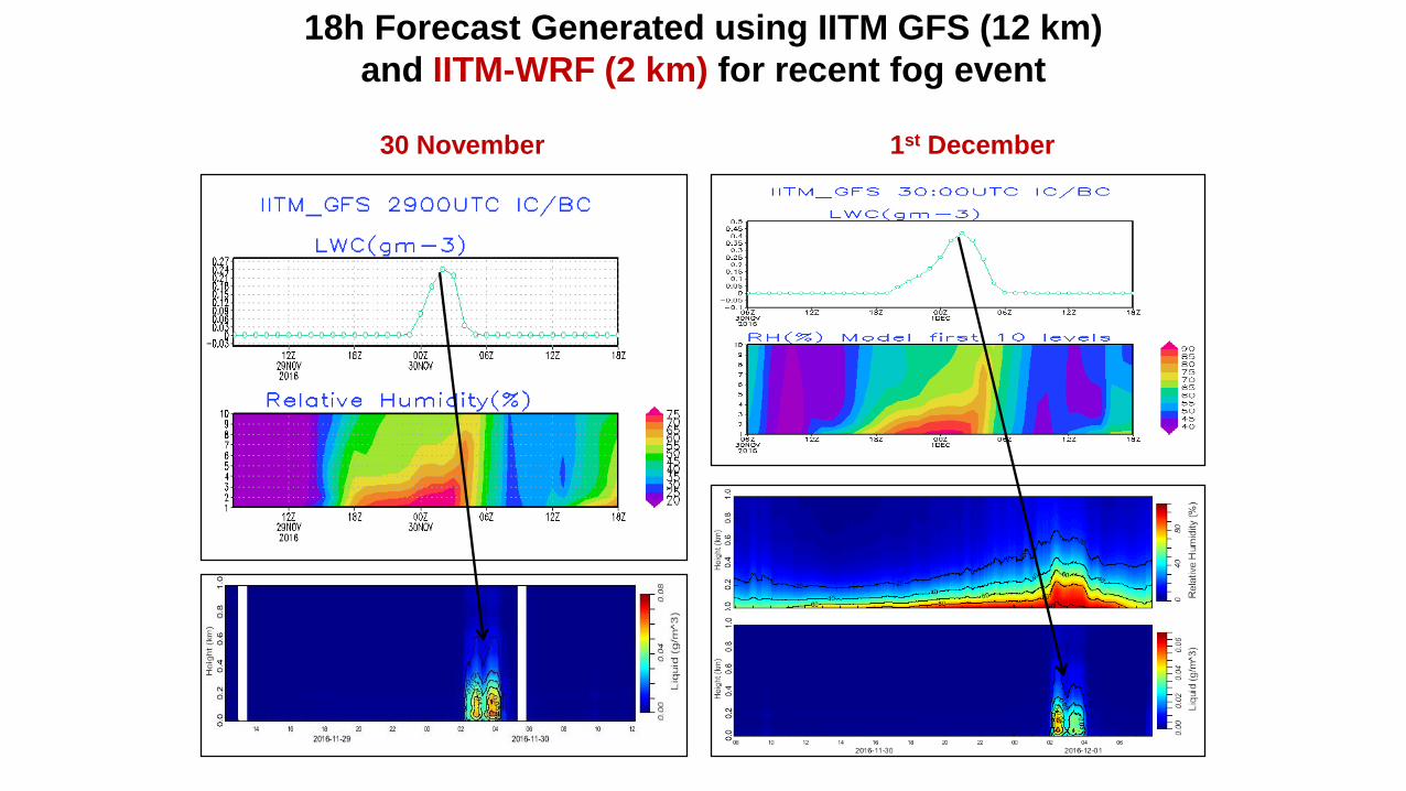
18h Forecast Generated using IITM GFS (12 km)
and IITM-WRF (2 km) for recent fog event
30 November 1st December
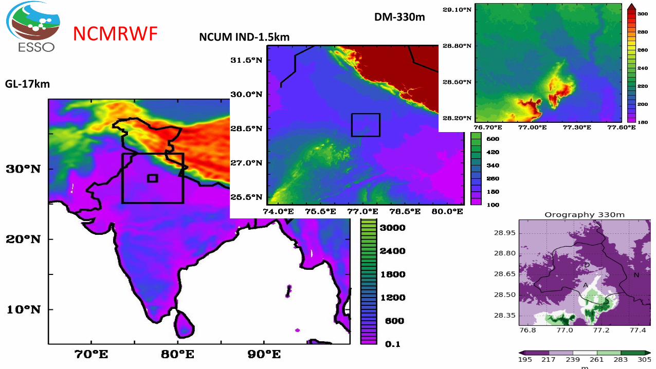
GL-17km
NCUM IND-1.5km
DM-330m
NCMRWF

DM model verification
The trend of visibility is predictedreasonably well by the model, however,model predicted visibility values aremuch higher
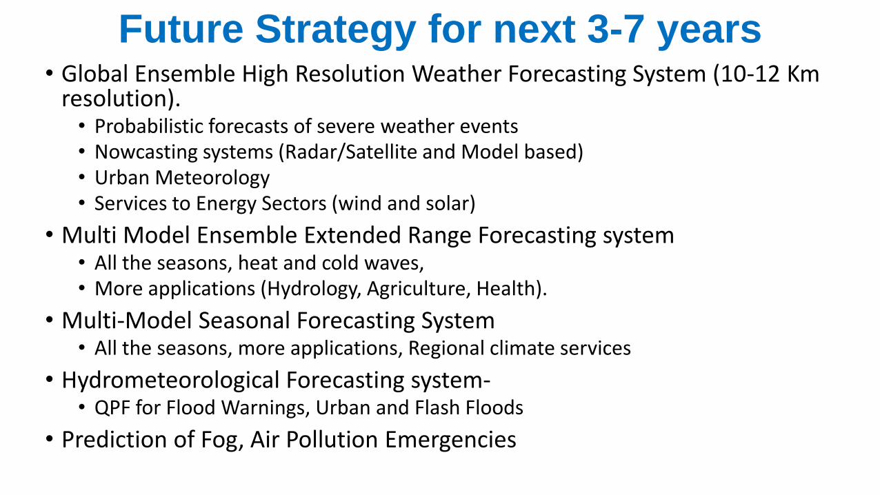
Future Strategy for next 3-7 years• Global Ensemble High Resolution Weather Forecasting System (10-12 Km
resolution).• Probabilistic forecasts of severe weather events• Nowcasting systems (Radar/Satellite and Model based)• Urban Meteorology• Services to Energy Sectors (wind and solar)
• Multi Model Ensemble Extended Range Forecasting system• All the seasons, heat and cold waves, • More applications (Hydrology, Agriculture, Health).
• Multi-Model Seasonal Forecasting System • All the seasons, more applications, Regional climate services
• Hydrometeorological Forecasting system-• QPF for Flood Warnings, Urban and Flash Floods
• Prediction of Fog, Air Pollution Emergencies

Observations and Services• Augmentation of regional meteorological observational network
• Ideally 25 X 25 km surface and 100 X 100 km upper air, supplemented by satellite, RADARs, lightning sensors, LIDARs, Radiometers etc
• Improved Agro-meteorological Services• Block Level Forecasts through 660 District Centres
• Research Testbeds• Fog Prediction- at IIG Airport, Delhi
• Monsoon Convection- At Sagar University, Madhya Pradesh, Bhubaneshwar
• Climate Reference Stations• Climate Change Monitoring
• To start with 50 Pristine locations
• Special Observational network over NW Himalayas and North-eastern States.

Thank you

![CONTENTS *Tropics -ENSO [Neutral] -MJO *Extra-tropics *Verification of ASO & October 2014 Outlooks *Drought *Selected Weather/Climate Events *Outlooks](https://img.pdfslide.tips/doc/110x75/56649d705503460f94a51e0b/contents-tropics-enso-neutral-mjo-extra-tropics-verification-of-aso.jpg)