Embed Size (px)
Citation preview
What is Geodesy? 1
Open GIS ConsortiumOpen GIS Consortium
for a changing world.
Spatial connectivity
What is What is Geodesy Geodesy ??
Roel Nicolaisenior consultant Geomatics and GIS
Shell Exploration and Production Technology Application and Research
(SEPTAR)
Rijswijk - The Netherlands
What is Geodesy? 2
Open GIS ConsortiumOpen GIS Consortium
for a changing world.
Spatial connectivity
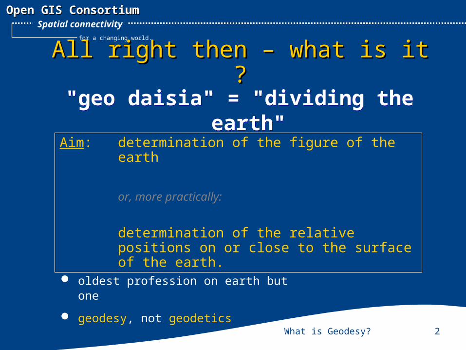
All right then – what is it ?All right then – what is it ?
"geo daisia" = "dividing the earth"
"geo daisia" = "dividing the earth"
Aim: determination of the figure of the earth
or, more practically:
determination of the relative positions on or close to the surface of the earth.
oldest profession on earth but one
geodesy, not geodetics
What is Geodesy? 3
Open GIS ConsortiumOpen GIS Consortium
for a changing world.
Spatial connectivity
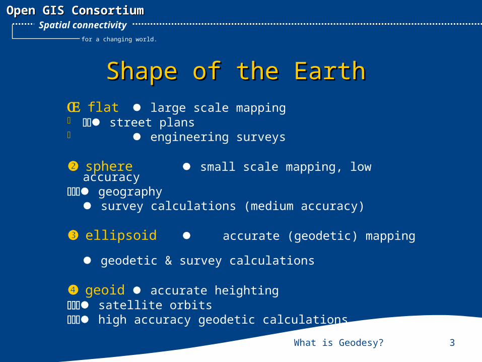
Shape of the EarthShape of the EarthŒflat large scale mapping street plans engineering surveys
spheresmall scale mapping, low accuracygeography
survey calculations (medium accuracy)
ellipsoid accurate (geodetic) mapping geodetic & survey calculations
geoid accurate heighting satellite orbitshigh accuracy geodetic calculations
What is Geodesy? 4
Open GIS ConsortiumOpen GIS Consortium
for a changing world.
Spatial connectivity
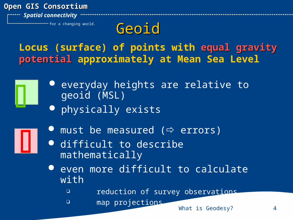
GeoidGeoidLocus (surface) of points with equal gravity equal gravity potentialpotential approximately at Mean Sea Level
must be measured (errors) difficult to describe mathematically even more difficult to calculate with
reduction of survey observations map projections
everyday heights are relative to geoid
(MSL) physically exists
What is Geodesy? 5
Open GIS ConsortiumOpen GIS Consortium
for a changing world.
Spatial connectivity
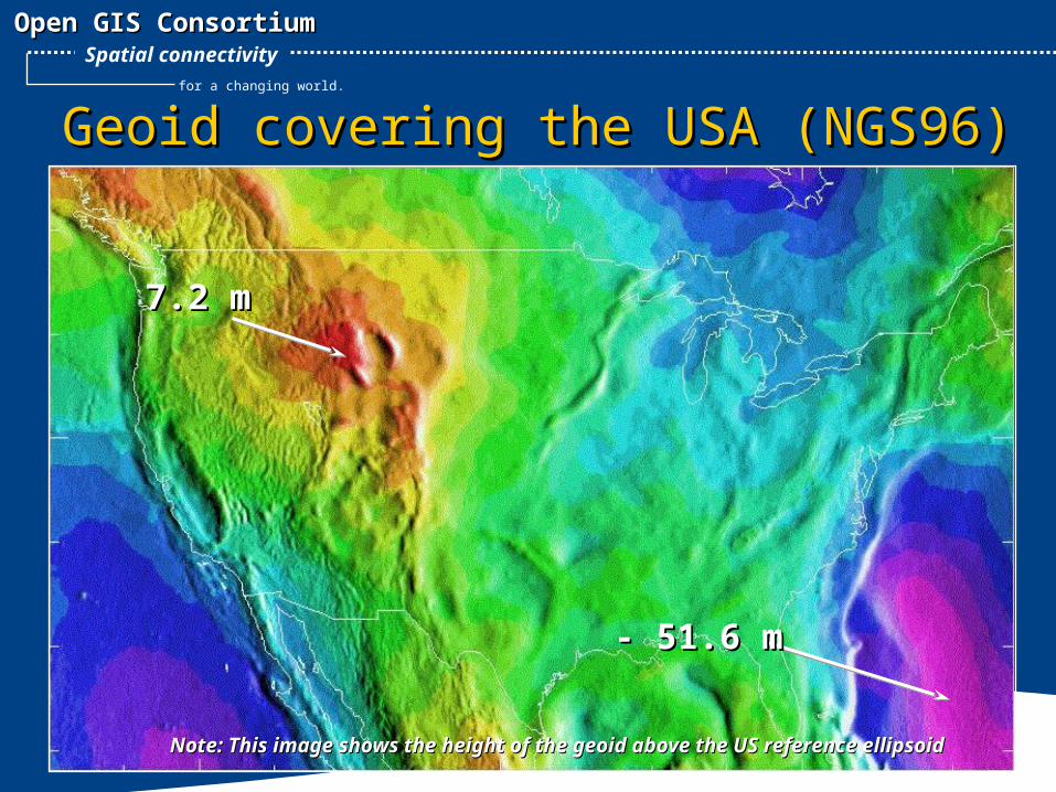
Geoid covering the USA (NGS96)Geoid covering the USA (NGS96)
7.2 m7.2 m
- 51.6 m- 51.6 m
Note: This image shows the height of the geoid above the US reference ellipsoidNote: This image shows the height of the geoid above the US reference ellipsoid
What is Geodesy? 6
Open GIS ConsortiumOpen GIS Consortium
for a changing world.
Spatial connectivity
What is Geodesy? 7
Open GIS ConsortiumOpen GIS Consortium
for a changing world.
Spatial connectivity
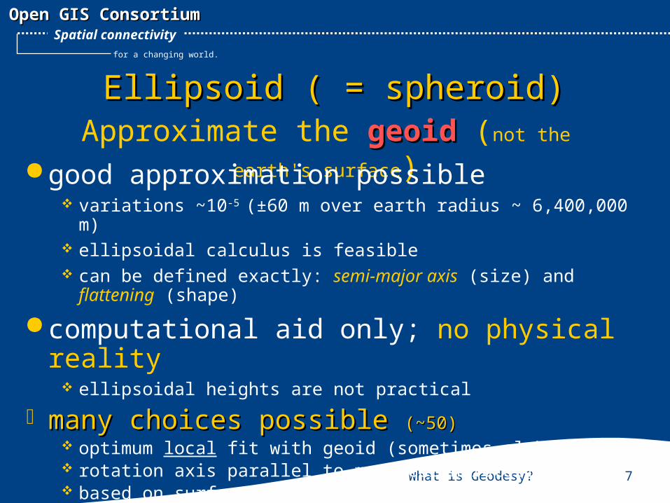
Ellipsoid ( = spheroid)Ellipsoid ( = spheroid)Approximate the geoid geoid (not the earth's
surface) good approximation possible variations ~10-5 (±60 m over earth radius ~ 6,400,000 m) ellipsoidal calculus is feasible can be defined exactly: semi-major axis (size) and flattening
(shape)
computational aid only; no physical reality ellipsoidal heights are not practical
many choices possible many choices possible (~50)(~50) optimum local fit with geoid (sometimes global fit) rotation axis parallel to mean earth rotation axis based on surface geodetic observations
What is Geodesy? 8
Open GIS ConsortiumOpen GIS Consortium
for a changing world.
Spatial connectivity
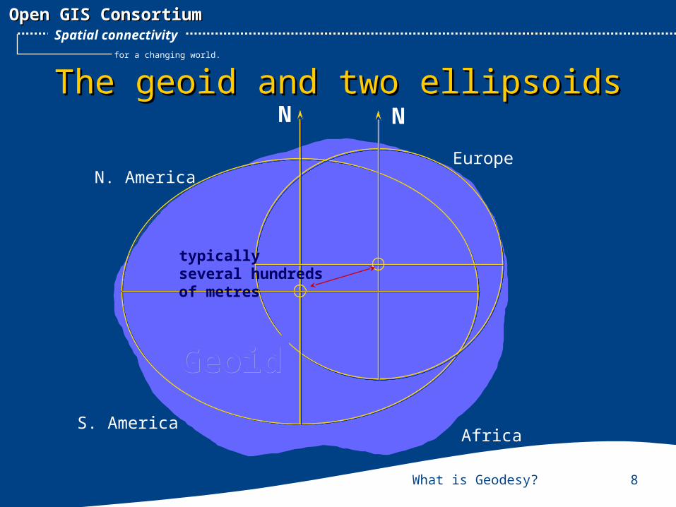
The geoid and two ellipsoidsThe geoid and two ellipsoidsNN
EuropeN. America
S. AmericaAfrica
GeoidGeoid
typically several hundreds of metres
What is Geodesy? 9
Open GIS ConsortiumOpen GIS Consortium
for a changing world.
Spatial connectivity
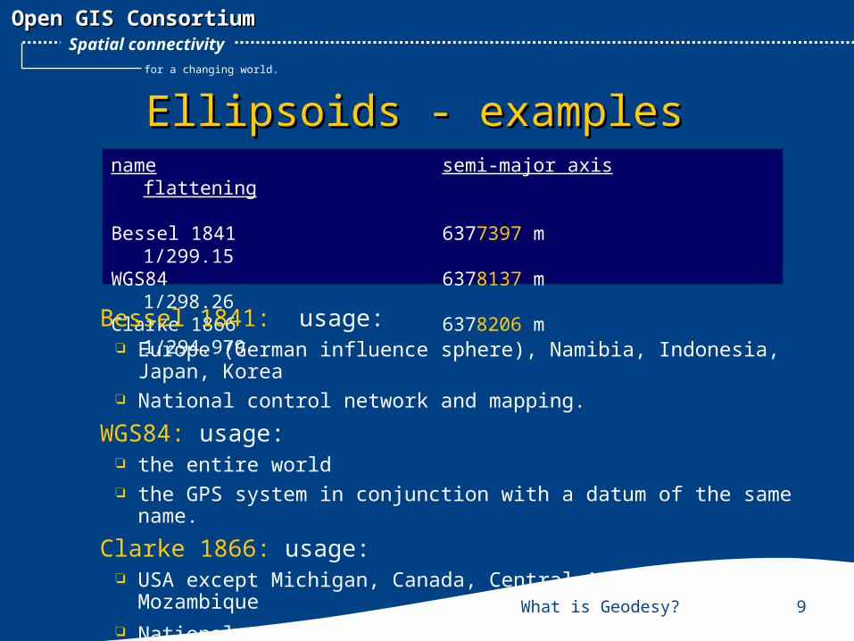
Ellipsoids - examplesEllipsoids - examplesname semi-major axis
flattening
Bessel 1841 6377397 m1/299.15
WGS84 6378137 m1/298.26
Clarke 1866 6378206 m1/294.979
Bessel 1841: usage: Europe (German influence sphere), Namibia, Indonesia, Japan, Korea National control network and mapping.
WGS84: usage: the entire world the GPS system in conjunction with a datum of the same name.
Clarke 1866: usage: USA except Michigan, Canada, Central America, Philippines,
Mozambique National control network and mapping.
What is Geodesy? 10
Open GIS ConsortiumOpen GIS Consortium
for a changing world.
Spatial connectivity
Many ellipsoids …. many datumsMany ellipsoids …. many datums
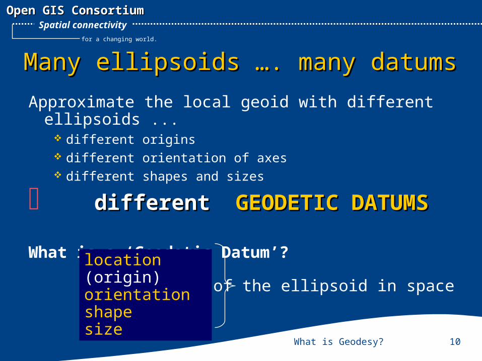
Approximate the local geoid with different ellipsoids ...
different origins different orientation of axes different shapes and sizes
differentdifferent GEODETIC DATUMS GEODETIC DATUMS
What is a ‘Geodetic Datum’?location (origin)orientation shapesize
of the ellipsoid in space
What is Geodesy? 11
Open GIS ConsortiumOpen GIS Consortium
for a changing world.
Spatial connectivity
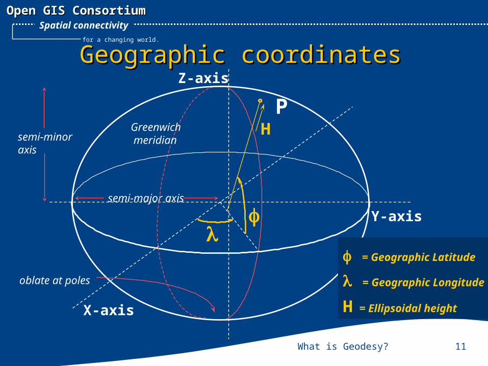
Geographic coordinatesGeographic coordinates
P
X-axis
Y-axis
Z-axis
semi-major axis
H Greenwich meridiansemi-minor
axis
oblate at poles
= Geographic Latitude
= Geographic Longitude
H = Ellipsoidal height
What is Geodesy? 12
Open GIS ConsortiumOpen GIS Consortium
for a changing world.
Spatial connectivity
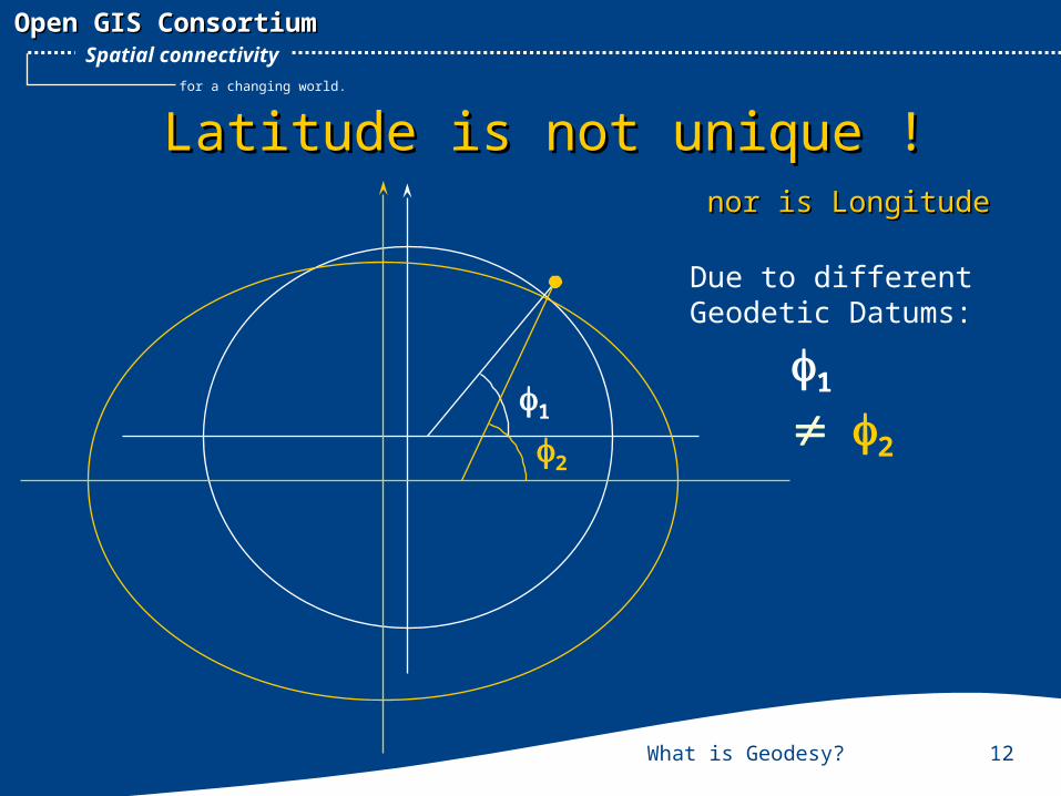
Latitude is not unique !Latitude is not unique !
1
2
nor is Longitudenor is Longitude
1
2
Due to different Geodetic Datums:
What is Geodesy? 13
Open GIS ConsortiumOpen GIS Consortium
for a changing world.
Spatial connectivity
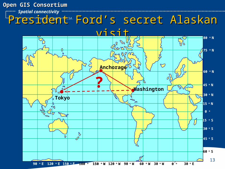
President Ford’s secret Alaskan visitPresident Ford’s secret Alaskan visit
Why not the shorter route?
0 o
15 o N
30 o N
45 o N
60 o N
75 o N
80 o N
15 o S
30 o S
45 o S
60 o S
0 o 30 o E30 o W60 o W90 o W120 o W150 150 o o WW180 o 150 o E120 o E90 o E
Anchorage
Washington
Tokyo
?
What is Geodesy? 14
Open GIS ConsortiumOpen GIS Consortium
for a changing world.
Spatial connectivity
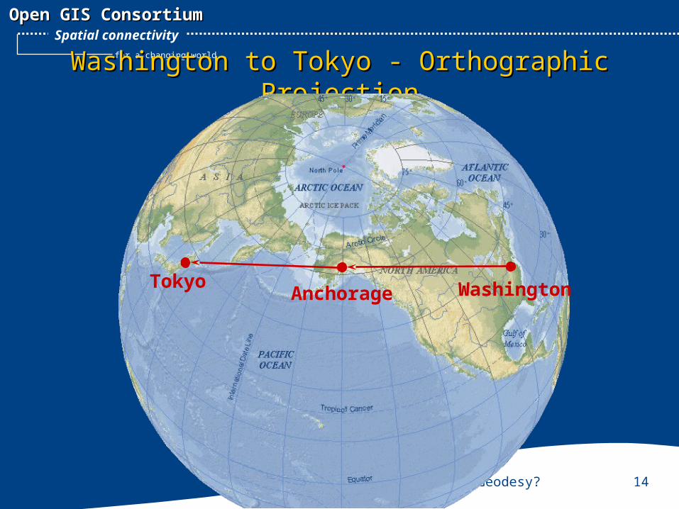
Washington to Tokyo - Orthographic ProjectionWashington to Tokyo - Orthographic Projection
TokyoAnchorage Washington
What is Geodesy? 15
Open GIS ConsortiumOpen GIS Consortium
for a changing world.
Spatial connectivity
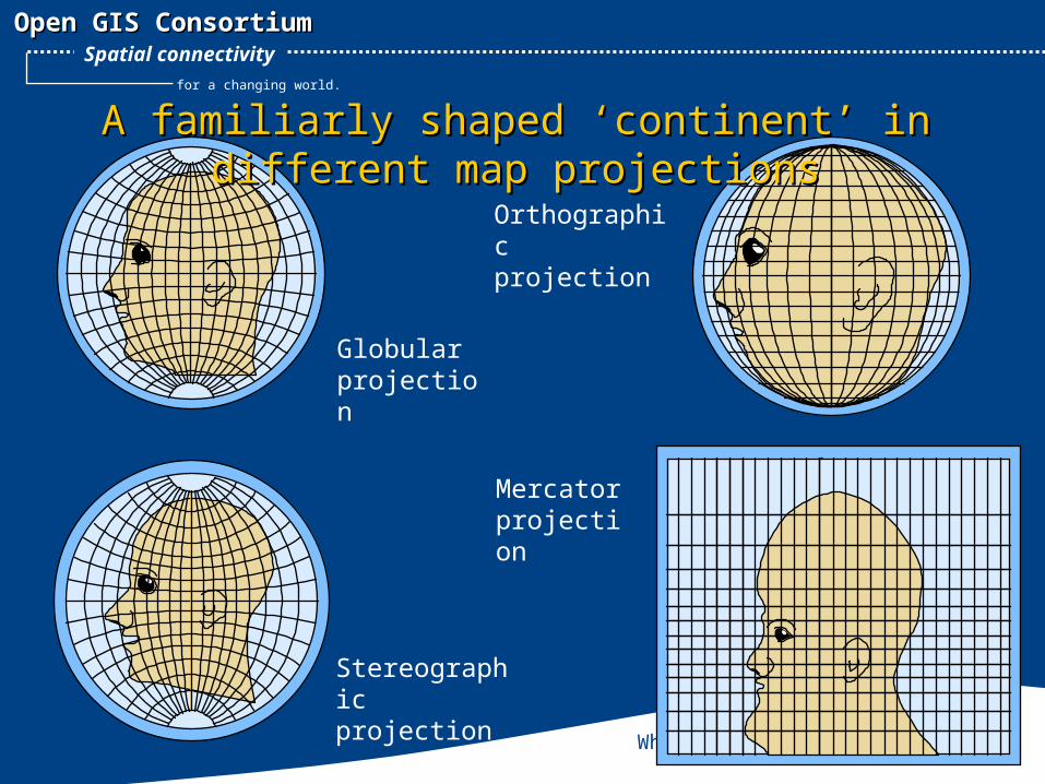
Mercator projection
Globular projection
Orthographic projection
Stereographic projection
A familiarly shaped ‘continent’ in different A familiarly shaped ‘continent’ in different map projectionsmap projections
What is Geodesy? 16
Open GIS ConsortiumOpen GIS Consortium
for a changing world.
Spatial connectivity
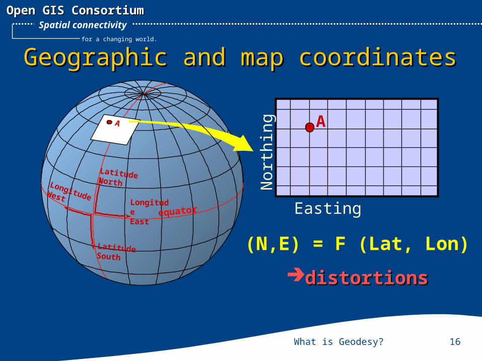
Easting
Northing
LongitudeEast
Longitude West
equator
LatitudeNorth
LatitudeSouth
AA
Geographic and map coordinatesGeographic and map coordinates
(N,E) = F (Lat, Lon)
distortionsdistortions
What is Geodesy? 17
Open GIS ConsortiumOpen GIS Consortium
for a changing world.
Spatial connectivity
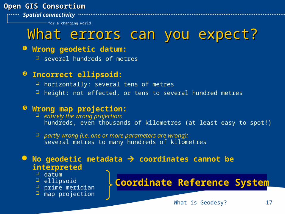
What errors can you expect?What errors can you expect? Wrong geodetic datum:
several hundreds of metres
Incorrect ellipsoid: horizontally: several tens of metres height: not effected, or tens to several hundred metres
Wrong map projection: entirely the wrong projection:
hundreds, even thousands of kilometres (at least easy to spot!)
partly wrong (i.e. one or more parameters are wrong):several metres to many hundreds of kilometres
No geodetic metadata coordinates cannot be interpreted
datum ellipsoid prime meridian map projection
Coordinate Reference SystemCoordinate Reference System
What is Geodesy? 18
Open GIS ConsortiumOpen GIS Consortium
for a changing world.
Spatial connectivity
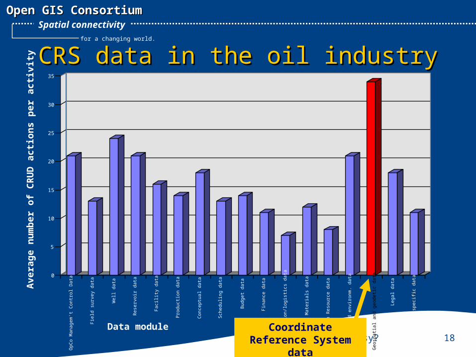
CRS data in the oil industryCRS data in the oil industry
0
5
10
15
20
25
30
35
Avera
ge n
um
ber
of
CR
UD
acti
on
s p
er
acti
vit
y
Fie
ld s
urve
y da
ta
Wel
l dat
a
Res
ervo
ir da
ta
Fac
ility
dat
a
Pro
duct
ion
data
Con
cept
ual d
ata
Sch
edul
ing
data
Bud
get d
ata
Fin
ance
dat
a
Tra
nspo
rtat
ion/
logi
stic
s da
ta
Mat
eria
ls d
ata
Hum
an R
esou
rce
data
Saf
ety
and
envi
ronm
. dat
a
Geo
spat
ial a
nd g
eode
tic d
ata
Lega
l dat
a
IC s
peci
fic d
ata
OpC
o M
anag
em't
Con
trol
Dat
a
Data module Coordinate Reference System
data
What is Geodesy? 19
Open GIS ConsortiumOpen GIS Consortium
for a changing world.
Spatial connectivity
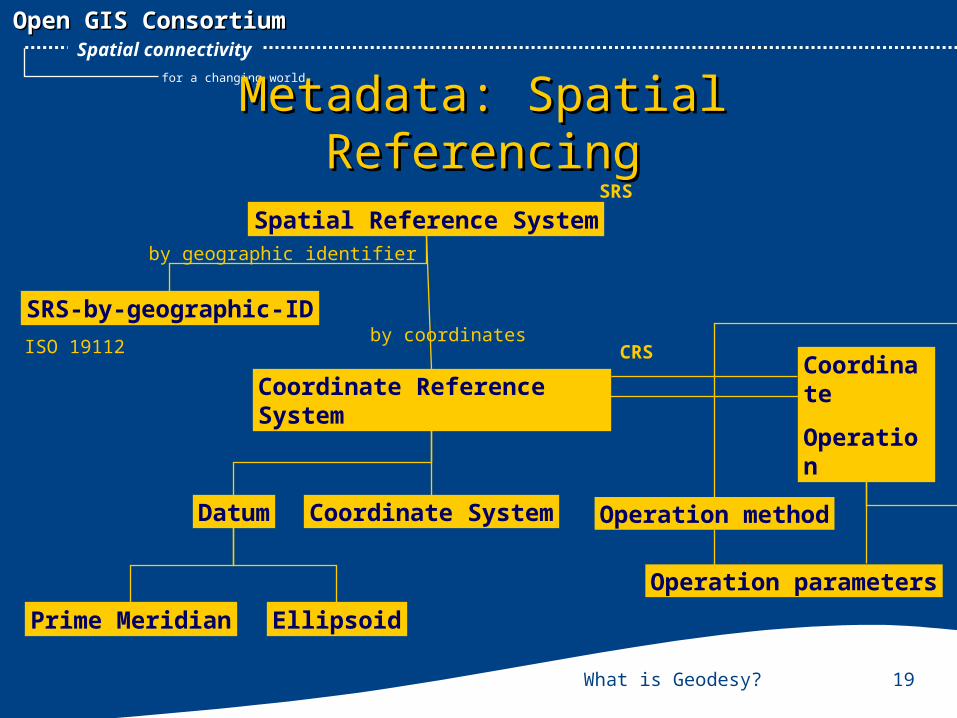
Metadata: Spatial ReferencingMetadata: Spatial Referencing
Prime Meridian Ellipsoid
Datum Coordinate System
Coordinate
Operation
ISO 19112
SRS-by-geographic-ID
by geographic identifier
Spatial Reference SystemSRS
Coordinate Reference System
by coordinatesCRS
Operation method
Operation parameters
What is Geodesy? 20
Open GIS ConsortiumOpen GIS Consortium
for a changing world.
Spatial connectivity
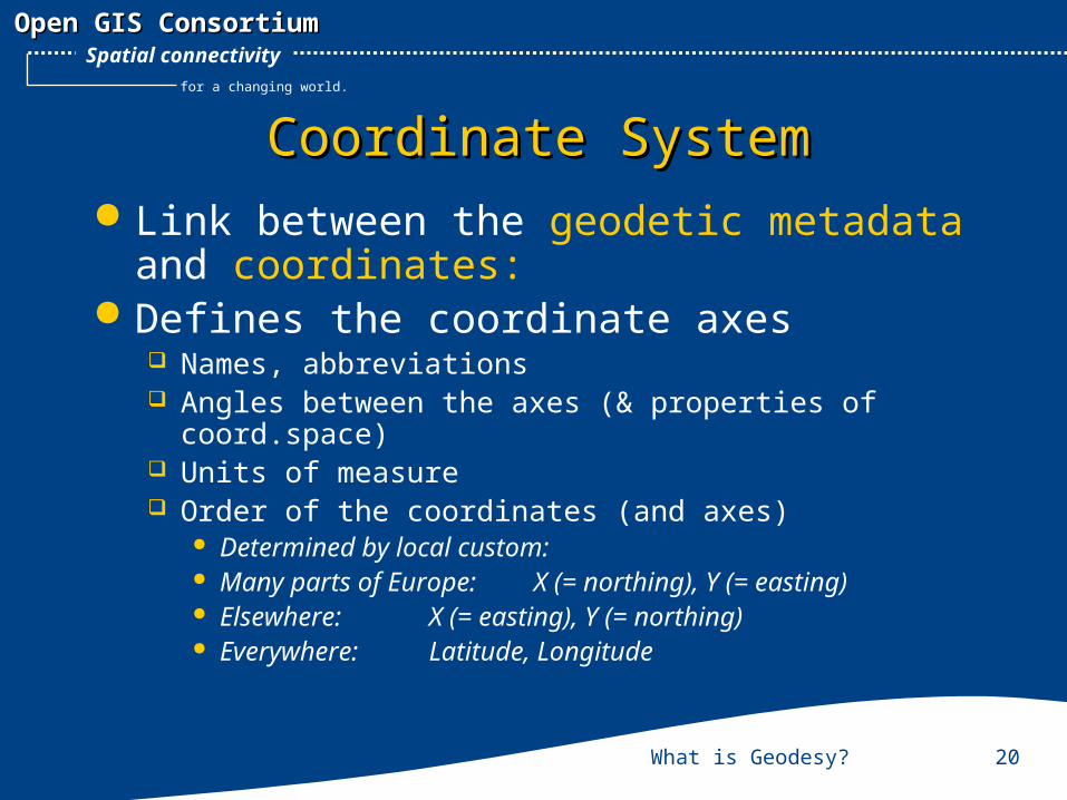
Coordinate SystemCoordinate System Link between the geodetic metadata
and coordinates: Defines the coordinate axes
Names, abbreviations Angles between the axes (& properties of
coord.space) Units of measure Order of the coordinates (and axes)
Determined by local custom: Many parts of Europe: X (= northing), Y (= easting) Elsewhere: X (= easting), Y (= northing) Everywhere: Latitude, Longitude
What is Geodesy? 21
Open GIS ConsortiumOpen GIS Consortium
for a changing world.
Spatial connectivity
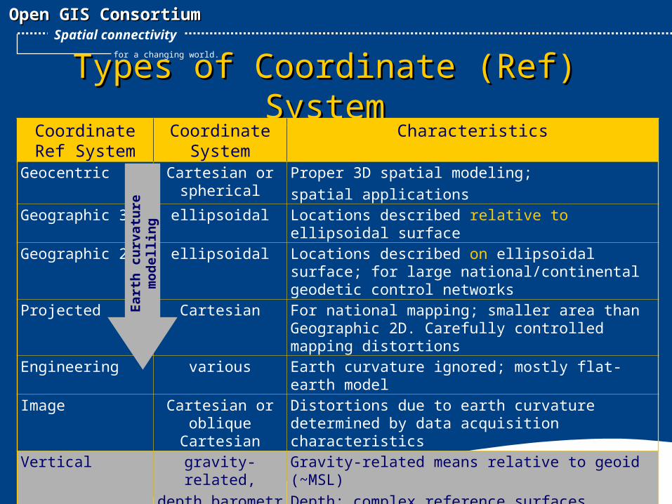
Types of Coordinate (Ref) SystemTypes of Coordinate (Ref) SystemCoordinate Ref
SystemCoordinate
SystemCharacteristics
Geocentric Cartesian or spherical
Proper 3D spatial modeling;spatial applications
Geographic 3D ellipsoidal Locations described relative to ellipsoidal surface
Geographic 2D ellipsoidal Locations described on ellipsoidal surface; for large national/continental geodetic control networks
Projected Cartesian For national mapping; smaller area than Geographic 2D. Carefully controlled mapping distortions
Engineering various Earth curvature ignored; mostly flat-earth modelImage Cartesian or
oblique Cartesian
Distortions due to earth curvature determined by data acquisition characteristics
Vertical gravity-related,depth,barometri
c
Gravity-related means relative to geoid (~MSL)Depth: complex reference surfaces (tidal)
Eart
h c
urv
atu
re
mod
ellin
g
What is Geodesy? 22
Open GIS ConsortiumOpen GIS Consortium
for a changing world.
Spatial connectivity
EPSG Geodesy WGEPSG Geodesy WG Working Group of EPSG
European Petroleum Survey Group Members:
Roger Lott – BP/Amoco (chair) Roel Nicolai – Shell Jim Cain – geodetic consultant, formerly Western Atlas Bruno Ravanas – TotalElfFina Alan Faichney – Society of Exploration Geophysicists Geir Simensen – Statoil (Norway)
Approached by POSC in 1992 Geodetic advice on EPICENTRE data modelling Suppliers of geodetic reference parameters
Website: www.epsg.org (hosted by IHS Energy) US sister established in 1999: APSG
What is Geodesy? 23
Open GIS ConsortiumOpen GIS Consortium
for a changing world.
Spatial connectivity
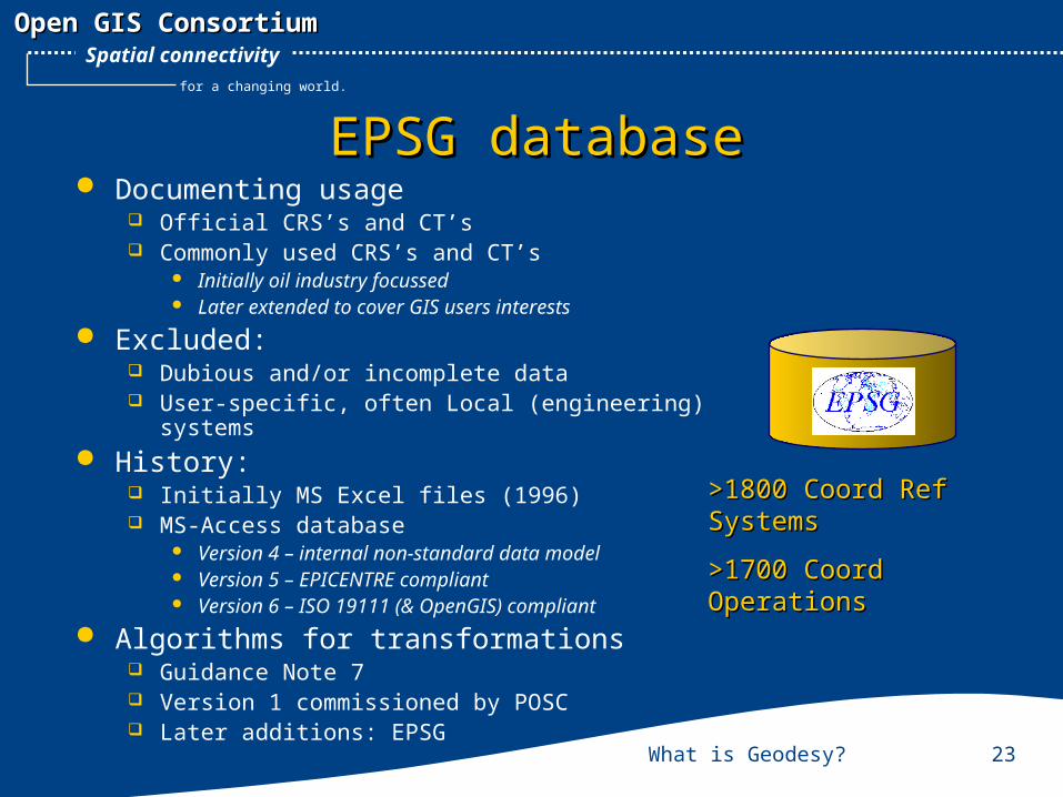
EPSG databaseEPSG database Documenting usage
Official CRS’s and CT’s Commonly used CRS’s and CT’s
Initially oil industry focussed Later extended to cover GIS users interests
Excluded: Dubious and/or incomplete data User-specific, often Local (engineering) systems
History: Initially MS Excel files (1996) MS-Access database
Version 4 – internal non-standard data model Version 5 – EPICENTRE compliant Version 6 – ISO 19111 (& OpenGIS) compliant
Algorithms for transformations Guidance Note 7 Version 1 commissioned by POSC Later additions: EPSG
>1800 Coord Ref >1800 Coord Ref SystemsSystems
>1700 Coord >1700 Coord OperationsOperations
What is Geodesy? 24
Open GIS ConsortiumOpen GIS Consortium
for a changing world.
Spatial connectivity
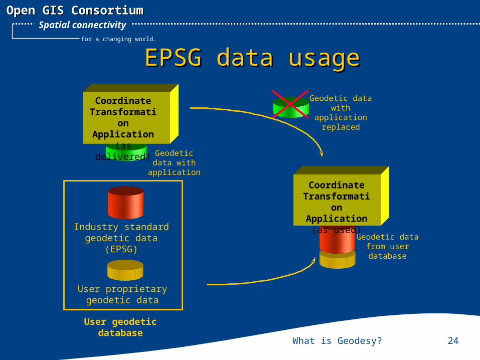
EPSG data usageEPSG data usage
Coordinate Transformati
on Application(as delivered)
Geodetic data with
application
Geodetic data from user database
Geodetic data with application
replaced
Coordinate Transformati
on Application
(as used)Industry standard geodetic data
(EPSG)
User geodetic database
User proprietary geodetic data
What is Geodesy? 25
Open GIS ConsortiumOpen GIS Consortium
for a changing world.
Spatial connectivity
EPSG data deprecation policyEPSG data deprecation policy New policy w.e.f. July 2001 No data will be deleted
ISO and SEG requirement Critical data in error
i.e. numerical integrity of coordinate data affected by error new record(s) created with correct data incorrect record marked as deprecated (+date and reason) replacement path will be recorded dependent records also deprecated and replaced Change recorded explaining actions
Non-critical data in error correction of data in record; revision date changed Change recorded
Superseded data (in usage) data stays in; comment added
What is Geodesy? 26
Open GIS ConsortiumOpen GIS Consortium
for a changing world.
Spatial connectivity
Some myths about EPSGSome myths about EPSG “Reference to an EPSG number is all I need to solve all my
spatial referencing problems” EPSG cannot hope to record all CRS and CT data You need to check whether data is still valid
“EPSG precribe how they believe CRS data should be used” EPSG record common usage and established practice
“EPSG is liable for any errors in their database” EPSG makes every effort to minimize the number of errors EPSG have made a disclaimer on liability resulting from errors
“ISO 19127 is going to make the EPSG database obsolete” ISO 19127 only collects ‘official’ parameters ISO 19127 data will be included in the EPSG dataset
What is Geodesy? 27
Open GIS ConsortiumOpen GIS Consortium
for a changing world.
Spatial connectivity
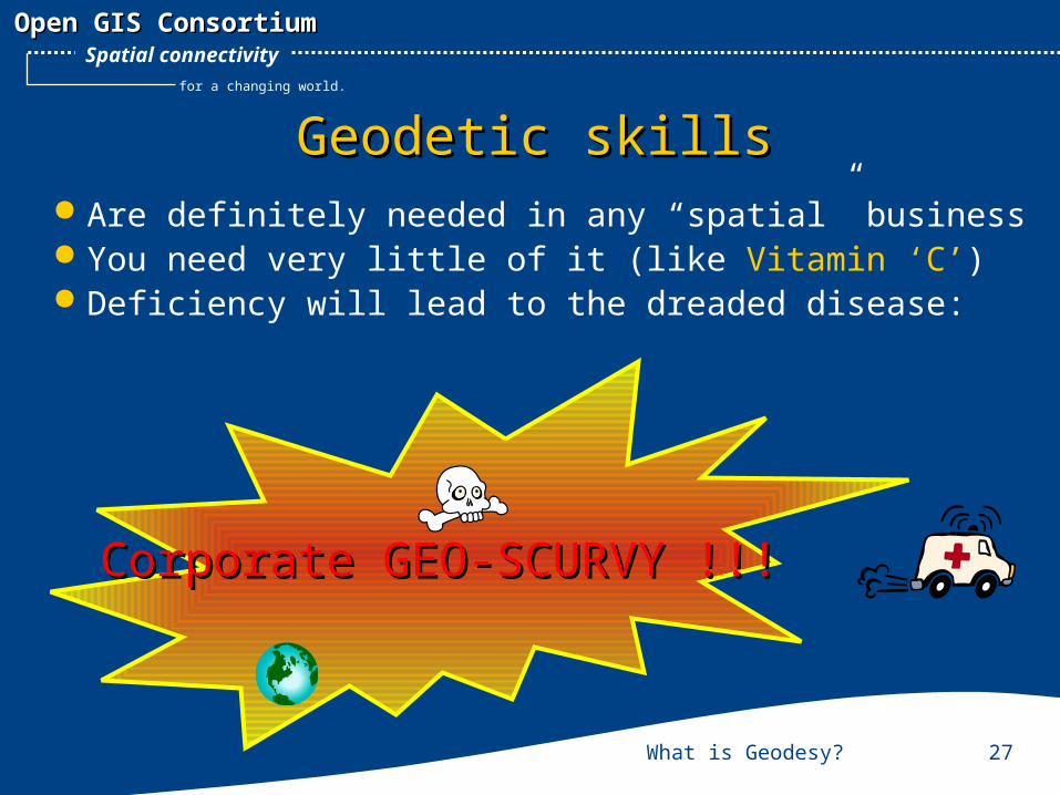
Geodetic skillsGeodetic skills Are definitely needed in any “spatial” business You need very little of it (like Vitamin ‘C’) Deficiency will lead to the dreaded disease:
Corporate GEO-SCURVY !!!Corporate GEO-SCURVY !!!