Embed Size (px)
Citation preview
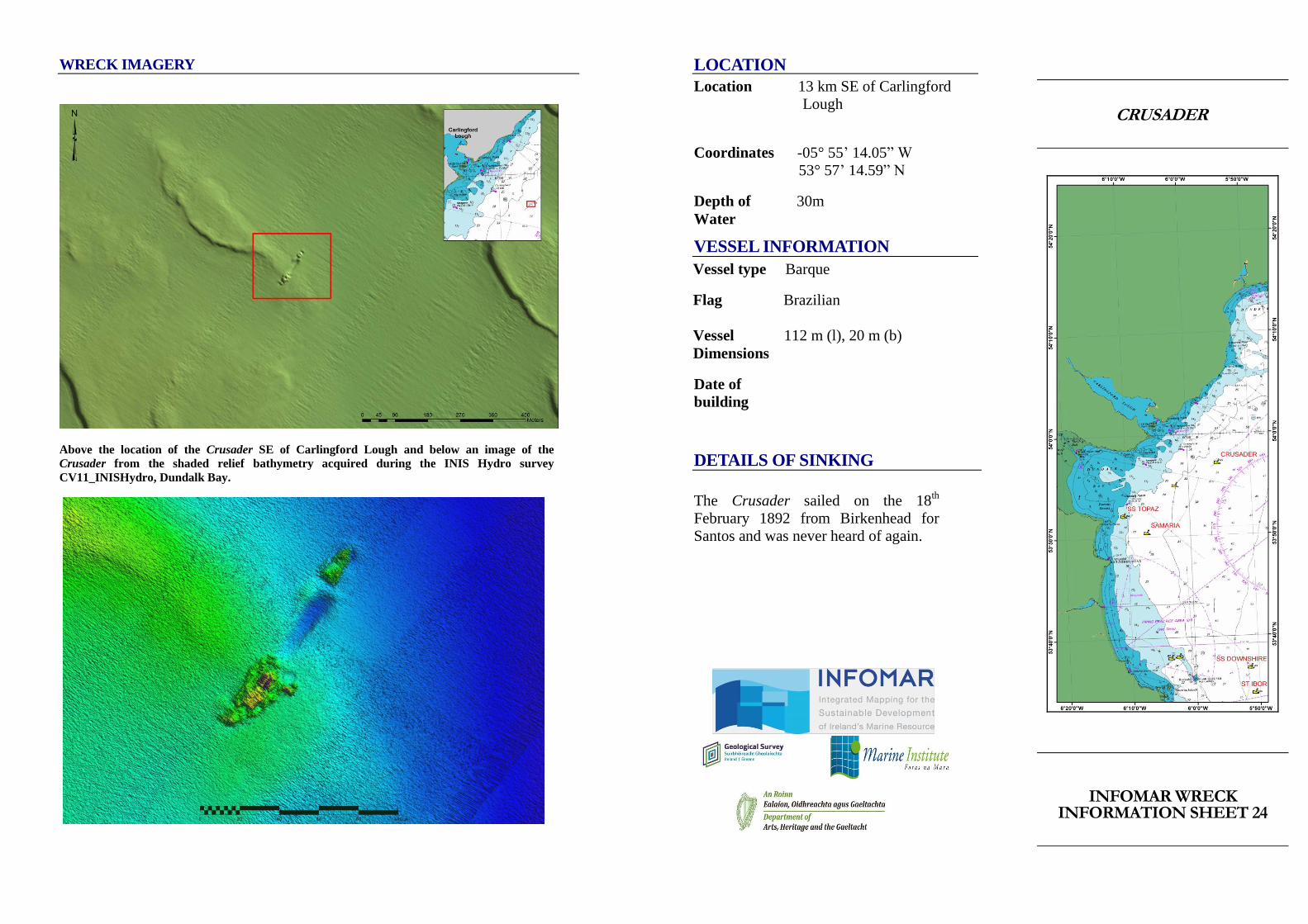
WRECK IMAGERY
Above the location of the Crusader SE of Carlingford Lough and below an image of the
Crusader from the shaded relief bathymetry acquired during the INIS Hydro survey
CV11_INISHydro, Dundalk Bay.
LOCATION
Location 13 km SE of Carlingford
Lough
Coordinates -05° 55’ 14.05” W
53° 57’ 14.59” N
Depth of 30m
Water
VESSEL INFORMATION
Vessel type Barque
Flag Brazilian
Vessel 112 m (l), 20 m (b)
Dimensions
Date of
building
DETAILS OF SINKING
The Crusader sailed on the 18th
February 1892 from Birkenhead for
Santos and was never heard of again.
CRUSADER
INFOMAR WRECK INFORMATION SHEET 24
VESSEL HISTORY
The Crusader was a 500-1000 ton vessel. It
is believed to be pre-1900 because of the
style of port holes seen when dived on in
1977. Silver cutlery was also recovered with
name 'Crusader' on it.
DIVE INFORMATION
The wreck of the Crusader lies in two parts
with no scour. It is believed that the wreck
Wrecks over 100 years old and
archaeological objects found underwater are
protected under the National Monuments
(Amendment) Acts 1987 and 1994. As the
Crusader is over 100 years old, it is
protected and a license is required to dive
the site which can be obtained from:
https://www.archaeology.ie/licences/dive-
survey-licence
Under the legislation all diving on protected
wreck sites or with the intention of
searching for archaeological underwater
material is subject to such licensing
requirements.
ABOUT INFOMAR
Covering some 125,000 square
kilometres of underwater territory,
INFOMAR (the INtegrated Mapping
FOr the Sustainable Development of
Ireland’s MARine Resource) project
will produce integrated mapping
products covering the physical,
chemical and biological features of the
seabed. INFOMAR will initially focus
on 26 priority bays and three priority
areas around the coast delivering:
hydrographic maps, illustrating
everything from sandbars to underwater
canyons and cliffs; seabed classification
maps showing the type of sediment on
the seabed. INFOMAR provides key
baseline data to support coastal and
inshore development. Making this
information available to the world aims
to stimulate research and development
of Ireland’s 220 million acres under the
sea. The data will be of interest to
fisheries managers, aquaculture
operators, coastal zone managers and
engineers, offshore engineering
interests, licensing authorities and those
carrying out environmental impact
assessments. Indeed this unique dataset
is of interest in its own right because of
the sheer volume of data collected
FURTHER READING/REFERENCES
www.infomar.ie
https://www.archaeology.ie/underwater-
archaeology
www.irishwrecksonline.net
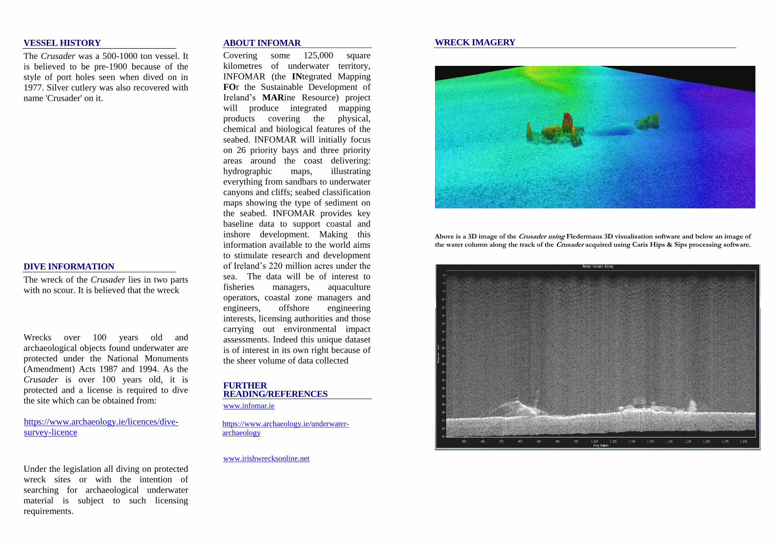
WRECK IMAGERY
Above is a 3D image of the Crusader using Fledermaus 3D visualisation software and below an image of the water column along the track of the Crusader acquired using Caris Hips & Sips processing software.