INERSIA Vol. 2 No. 1 (Maret 2006) pp 55-65
APLIKASIPROGRAM TOPOCAD UNTUK PENGGAMBARANHASIL UKUR TANAH
Sunar RochmadiStaf Pengajar Fakultas Teknik UNY
Afif NofaridaAlumni Fakultas Teknik UNY
ABSTRACTConstruction works need various drawings, including the drawings of
earth surface profiles used to prepare plan and design of construction works.If the drawing process of earth surface profile is conducted manually, it will takerelatively longer time. Using Topocad program it is hoped to produce highprecission earth surface profiles. This research aims to prove that the drawingprocess is more effective and efficient using Topocad computer program.
This research was conducted using the Football Field ReplacementDevelopment Project in Dusun Kayen, Desa Sinduadi, Kecamatan Mlati,Kabupaten Sleman, Yogyakarta. The field measurement was conducted togather data used to calculate distance and height difference between points.The data were processed in the Surveying Laboratory, FaCUlty of Engineering,UN~
Based on data analysis, it is concluded that the calculation process ofsurveying data is more effective and efficient supported by Microsoft Excelsoftware. Applying Topocad program using the surveying data results singlecross sections, multiple cross section, single long section, polygon and crosssection detail were drawn digitally. The drawings produced utiliZing Topocadprogram are easy to be edited and therefore should be suitable for planningand designing civil construction works, because the drawings are in theenvironment of the AutoCAD software.
Key words: Earth surface~ profile, computer aided drawing, surveying drawing.
PENDAHULUAN
Dalam pekerjaan konstruksi sangatdibutuhkan adanya gambar profit ataupenampang permukaan tanah sebagailandasan utama dalam membuat rencanadan rancangan peke~aan. Seiring dengantuntutan zaman, gambar profit ataupenampang permukaan tanah diharapkanmempunyai ketelitian dan efisiensi waktudalam proses pembuatannya, sehinggaperlu digunakan alat bantu programkomputer untuk proses penggambarannya.
55
Perkembangan teknologi terutamakomputer dan program-programnya sangatmembantu dalam proses perhitungan danpenggambaran dengen akurasi yangcukup tinggi. Kemajuan teknologi jugamemberikan banyak pilihan untukmenyelesaikan suatu permasalahan.Pemilihan teknologi harus disesuaikandengan berbagai hal agar didapatkanpenyelesaian yang memuaskan. Di bidangpemetaan berbagai perkembangan telahdirasakan, mulai dari alat-alat optik dengan

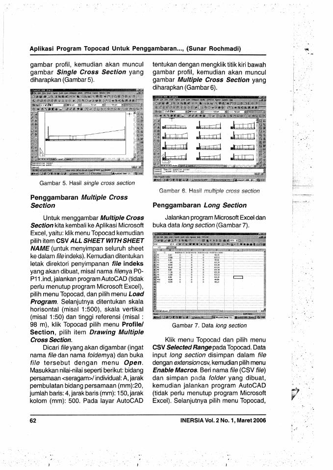
Recommended