LDF Evidence
Base
Rochford District Council October 2007
RochfordD i s t r i c t C o u n c i l
Local Development Framework
Evidence Base
Battlesbridge Conservation Area
Appraisal and Management Plan


Cantonese 如果你 需要 放大,盲
文資訊或者不同語言的
版本請聯絡 01702 546 366
Gujarati Spanish Si desea esta información impresa en letra grande, Braille o en otro idioma, por favor llame al teléfono 01702 546 366
Urdu
Portugese Caso necessite desta informação em impressão maior, em Braille ou noutra língua, por favor contacte 01702 546 366
Shona Kana uchida ruzivo, kana tsananguro iyi yakanyorwa nemavara makuru, kana kuthi yakanyorwa nerurimi rwemapofu, kana nerumwe rurimi, kana umwe mufauro sununguka kuti taurira parunare ronoti 01702 546 366
If you would like this information in
large print, Braille or another language please contact 01702 546 366
This document was produced for Rochford District Council and Chelmsford
Borough Council. The document was prepared by Karen Fielder, MA PGDip, of Essex County
Council’s Historic Buildings and Conservation Section, and Michael Hurst, BSc (Hons) MSc MRICS IHBC, of Chelmsford Borough Council’s Design and Development Coordination Section.
© Rochford District Council, Essex County Council and Chelmsford Borough
Council 2006 Ordnance Survey maps reproduced by permission of Ordnance Survey® on behalf
of the Controller of Her Majesty’s Stationery Office.© Crown Copyright. Licence number LA100019602
Aerial photograph © UK Perspectives
Contents 1. Introduction 1 2. Character statement 2 3. Statutory protection 3 4. Planning policies 5 Chelmsford Borough planning policies 5 Rochford District planning policies 6 5. Location and landscape setting 7 6. Origins and development 8 7. Character appraisal 12 Spatial analysis 13 Character analysis 17 Materials and details 17 Area 1 North of the River Crouch 22 Area 2 South of the River Crouch 29 Problems and pressures 35 8. Management proposals 35 Enhancement opportunities 36 Bibliography 40 Appendices Appendix 1 Listed buildings in the conservation area 41 Appendix 2 EHER sites in the conservation area 44

This page is intentionally blank.

1. INTRODUCTION 1.1 Battlesbridge is a small rural settlement on the upper estuary of the River Crouch,
situated partly within Chelmsford Borough and partly within Rochford District. It is located at the tidal limit of the river, where it forms an important crossing point. The history of Battlesbridge is intimately linked with the river, and its present appearance owes much to centuries of riverside industry. Today Battlesbridge is best known as a centre for antiques and collectables.
1.2 The Battlesbridge conservation area boundary is loosely drawn around the historic
industrial core of the settlement where the principal historic buildings are largely associated with functions relating to the river. It encompasses marsh and drainage land on both sides of the river. The bridge provides the focus at the centre of the conservation area. Other important structures and buildings include former mill buildings, the Barge Inn, farm buildings and cottages.
1.3 Conservation areas are ‘Areas of Special Architectural or Historic Interest, the
character or appearance of which it is desirable to preserve or enhance’ (Planning (Listed Buildings and Conservation Areas) Act 1990). Government Planning Policy Guidance 15, Planning and the Historic Environment, emphasises that the character of conservation areas derives not simply from the quality of individual buildings, but also depends on ‘the historic layout of property boundaries and thoroughfares; on a particular “mix” of uses; on characteristic materials; on appropriate scaling and detailing of contemporary buildings; on the quality of advertisements, shop fronts, street furniture and hard and soft surfaces; on vistas along streets and between buildings; and on the extent to which traffic intrudes and limits pedestrian use of space between buildings’ (para. 4.2).
1.4 Designation of a conservation area extends planning controls over certain types of
development, including extensions, boundary treatments, the demolition of unlisted buildings and works to trees. However it does not prevent any change and the area may be subject to pressures (good and bad) that will affect its character and appearance. Battlesbridge derives much of its special character from the surviving evidence of its historic role as a centre for riverside industrial activity. The decline of traditional industries has created pressures for change, and Battlesbridge has successfully reinvented itself as a centre for the sale of antiques and crafts since the 1960s. However some changes constitute a threat to the special character of Battlesbridge, including change of use of redundant buildings, new development, and demand for modernisation and improvement of existing properties.
1.5 This conservation area appraisal was prepared jointly by Essex County Council, on
behalf of Rochford District Council, and by Chelmsford Borough Council. The research and fieldwork were carried out in October 2006 and January 2007.
1.6 The appraisal provides a brief development history of the current settlement, followed
by a description and assessment of character. The contribution of its different elements to the character is identified. Any issues which may affect the protection of character will be highlighted and opportunities for enhancement identified.
1
2
2. CHARACTER STATEMENT 2.1 Battlesbridge is a small semi-industrial and rural settlement at the head of the
navigable part of the River Crouch, and forms an important crossing point on the river. The settlement derives much of its distinctive character from its intimate association with the river. The built environment has a mixed character reflecting past uses, and includes industrial, agricultural and domestic buildings of different periods. Former mill buildings are strong elements in the special character of the area. The tall Victorian granary is a landmark building on the north side, whilst the historic tide mill, drying kiln and tide gates to the south create a picturesque and timeless scene viewed across the mudflats and marsh. The bridge provides a focus for the conservation area, and is a fine piece of Victorian engineering. Views along the river are largely unspoilt, and mudflats, marsh and drainage channels are ever-present features of the settlement. The conservation area is spacious, open and informal, with large areas of open space within the boundary, including the village green, meadows, marsh and gardens, as well as the river channel itself. Trees and hedges contribute to the rural character of the area, particularly to the south and east.
Fig. 1 Old tide mill, mill cottages and drying kiln.
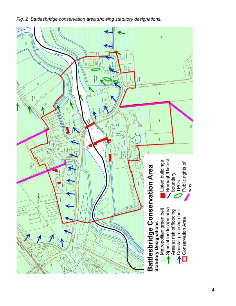
3. STATUTORY PROTECTION WITHIN THE CONSERVATION AREA (Fig. 2)
3.1 The conservation area was jointly designated by Chelmsford Borough Council (north
side of the river) and Rochford District Council (south side of the river) in February 1992 and March 1992 respectively.
3.2 There are seven listed buildings in the conservation area. These are the old tide mill
and attached dam wall, the old granary and drying kiln, the Hay Barn Antique Centre, the Barge Inn, the dovecote at Muggeridge’s Farm, Great Coopers farmhouse, and the road bridge. All of these are Grade II listed. Appendix 1 contains list descriptions for these buildings.
3.3 There are three public rights of way in the conservation area marked on the Definitive
Map of footpaths in Essex. Two paths head north from Maltings Road on either side of Muggeridge Farm, and one runs south from Chelmsford Road past Telfords heading towards Rawreth.
3.4 There is one Tree Preservation Order in the conservation area, within the Rochford
District area, covering three groups of willow trees off Beeches Road (ROC/30/92). However trees within the conservation area enjoy protection in as much as anyone within a conservation area carrying out works to a tree must give written notification to the local planning department at least six weeks beforehand.
3.5 The rural character of Battlesbridge and its wider setting is recognised by a number of
statutory designations. The settlement lies within Metropolitan Green Belt, where there is a general presumption against inappropriate development. Parts of the conservation area fall within the Essex Coastal Protection Belt which recognises the special and undeveloped character of parts of the Essex coastline. In addition the eastern part of the conservation area is set within a Special Landscape Area (SLA), designated as being of great landscape value, the conservation of which is considered to be important to the county’s natural heritage as well as at a local level. There is a presumption against development in an SLA unless it accords with the character of the area.
3.6 With its low-lying setting Battlesbridge is situated within an area that has been
designated as at risk of flooding. New developments must take into account the level of risk posed and must include appropriate flood mitigation and management measures.
3
4
Fig. 2 Battlesbridge conservation area showing statutory designations.
4. PLANNING POLICIES Chelmsford Borough Council Planning Policies Existing Statutory Planning Policy 4.1 The Chelmsford Borough Local Plan was adopted in 1997. Its objectives include
promoting sustainable development, protection and enhancement of towns, villages and countryside, minimising environmental damage and protection of the Green Belt.
4.2 The Local Plan includes specific planning objectives to preserve and enhance the
character and appearance of conservation areas. Emphasis is given to the siting and design of buildings, materials, spaces, landscaping and detailing.
4.3 The Local Plan contains policies to ensure proposals preserve or enhance the
character and appearance of conservation areas (ENV6), direct the preparation of enhancement schemes (ENV7) and encourage maintenance of buildings and features (ENV8). Shopfronts with character should be retained and appropriate design and materials used for new shopfronts (ENV16). ENV19 controls security grills and shutters and ENV17 and 18 advertising paraphernalia. Policies ENV9, 10 and 11 cover works to listed buildings, their re-use and maintenance. Assessment, recording and retention of archaeological remains are covered by ENV12 and 13.
4.4 The whole settlement is within the Metropolitan Green Belt. Battlesbridge is a small
hamlet and due to the informal layout and open character of the built settlement it does not form part of a defined settlement. There is a general presumption against inappropriate development. Local Plan policies restrict infilling (HO12), control replacement dwellings (HO14) and limit the extension of existing buildings (HO15).
4.5 The conservation area is defined as part of the coastal protection belt. The Coastal
Protection Subject Plan, a statutory plan adopted in 1984, defined the extent of the coastal areas within Essex where there would be the most stringent restriction on development due to the special character of the open and undeveloped coast. Policy CC1 of the Essex and Southend-on-Sea Replacement Structure Plan embodies the commitment to the Coastal Protection Belt. There is a presumption against development which is intrusive or undesirable.
4.6 The eastern part of the conservation area is defined as a Special Landscape Area.
These areas are defined as areas of greater than average visual quality. Development which detracts from an area’s character will not normally be allowed. The Essex and Southend-on-Sea Replacement Structure Plan (2001), Policy NR12, provides the basis for protection.
4.7 There is a general presumption against new development or the intensification of
development in areas liable to flooding, unless it can be demonstrated that appropriate flood protection measures will be undertaken (CSU8).
4.8 Abutting the conservation area to the north east is an area designated as an employment policy area, off Hawk Lane. Industrial uses are encouraged if they do not create environmental or amenity problems (EMP2).
5
Emerging Statutory Planning Policy 4.9 Chelmsford Borough Council has prepared a core strategy and development control
policies for its local development framework (LDF), to replace the 1997 local plan. These documents are expected to be adopted in late 2007. The table below compares the principal 1997 local plan policies relating to the conservation area and the comparable LDF policies.
1997 Local Plan Policy 2006 Core Policy 2006 Development Control Policy ENV6 Conservation Areas CP9 DC19 ENV7 Enhancement Schemes CP9 DC19 EHV8 Maintaining Conservation CP9 DC19 Areas ENV9-11 Listed Buildings CP9 DC20 ENV16 Shop fronts CP9 DC19, DC49 ENV17-18 Advertising CP9 DC49 ENV19 Security Shutters CP9 DC46, DC49 ENV12 & 13 Archaeology CP9 DC23
HO12, 14 & 15 Greenbelt CP5 DC1, DC2, DC12, DC13, DC51 RE19 River Valleys CP4, CP9 DC18, DC11
4.10 Special landscape designations with the existing structure plan will be covered by a landscape character assessment (Blandford Associates, 2006). Battlesbridge falls within the Fambridge drained estuarine marsh area
Rochford District Council Planning Policies 4.11 Rochford District Replacement Local Plan was adopted in June 2006. Its objectives
include promoting a green and sustainable environment, improving the quality of life for people in the District, and the maintenance and enhancement of local heritage.
4.12 The Replacement Local Plan includes specific planning objectives to protect and
enhance the historic character of settlements, particularly within conservation areas, and to formulate and publish a detailed assessment of each conservation area, indicating townscape features, buildings and spaces that distinguish the character of each conservation area, to be taken into consideration when new development is being proposed.
4.13 The Replacement Local Plan contains policies (BC1-2) formulated to ensure the
preservation of the special character of the conservation areas and to promote good design within them. Further guidance for the assessment of proposals for development in conservation areas is provided in Local Plan Supplementary Planning Document 6. Policies BC3-4 set out to protect listed buildings from demolition and from alterations, additions or change of use which might adversely affect important architectural or historic features. In addition policies BC5 and BC6 apply to
6
developments affecting archaeological sites. Policies SA8-11 are concerned with shop design and advertising in conservation areas.
4.14 The Replacement Local Plan also includes a range of policies dealing with
development in Green Belt (policies R1-R10), and there is a general presumption against inappropriate development. Development in many settlements and hamlets in the District that lie within Green Belt, including Battlesbridge and Rawreth, is considered to be of such a sporadic nature that to allow any new dwellings would have a detrimental effect on the visual appearance of the Green Belt and the existing open character of such settlements.
4.15 Policy NR10 of the Rochford District Replacement Local Plan sets out the local
planning authority’s approach when considering rural and undeveloped areas of coastline within the Coastal Protection Belt, and states that applications for development will not be granted planning permission unless it can be shown that the development would not adversely affect the open and rural character of the coastline, or its historic, wildlife or geological features.
4.16 Rochford District Council sets out its policy with regard to the protection of SLAs in
Policy NR1 of the Replacement Local Plan. This policy states that development will not be allowed unless its location, size, siting, design, materials and landscaping accord with the character of the area in which development is proposed.
4.17 Flood risk is a material planning consideration. Policy NR11 in the Replacement Local
Plan sets out the local planning authority’s approach to development proposals within flood risk areas. Applications for development in these areas must be accompanied by flood risk assessments to enable the Local Planning Authority to consider the level of risk posed to the development and the effectiveness of flood mitigation and management measures.
5. LOCATION AND LANDSCAPE SETTING 5.1 Battlesbridge is a small hamlet that straddles the upper reaches of the River Crouch. It
is set just east of the A130, about ten miles south of Chelmsford and four miles north of Rayleigh. The main road through the settlement links with the estuarine coast and other settlements such as Hockley, Ashingdon and Canewdon. Battlesbridge is divided between the parish of Rettendon to the north and Rawreth to the south, the parish boundary largely following the centre of the river channel.
5.2 The upper Crouch estuary provides the landscape setting for Battlesbridge, and
comprises a series of gently undulating valley sides. Battlesbridge is set on the flood plain, and the river remains tidal at this point. The river channel is fringed by mud, rough grassland and marsh. The current tidal defences remain largely in the same position as they appeared by the time of the First Edition OS map in 1876. The north side of the river is embanked, largely by earthworks except along the roadside and at the Battlesbridge Antiques Centre where there are concrete walls. Works have recently been carried out to enhance the tidal defences on the north side, including the raising of the embankments and increasing the height of the concrete walls with a new coping. A meander in the river channel west of the conservation area by what is
7
now a caravan park was straightened in the last 40 years, and the parish boundary follows the old river route at this point.
5.3 The river cuts through an area of low hills which developed on London Clay and
Claygate beds to the north and London Clay and Bagshot beds to the south, in places masked by river deposits and overlain by a thin layer of estuarine alluvium. Historically the marshlands provided good pasture, particularly for sheep, and the soils were suitable for arable cultivation which continues to contribute to the local economy today. The proximity to the river for transport of farm produce was an added encouragement to agricultural production in the area. There is some evidence of a historic rectilinear field pattern which may be medieval in date or earlier, with a grid structure on a broad north-south axis. However arable fields have suffered from boundary loss which has created prairie fields and eroded the historic landscape pattern.
5.4 The landscape around Battlesbridge includes a number of scattered medieval moated
sites that are typical of the dispersed settlement pattern of the area. These include Beeches Farm to the east of Battlesbridge (EHCR 7517). Others are mentioned in the inventory of historic monuments produced by the Royal Commission on Historic Monuments (England).
6. ORIGINS AND DEVELOPMENT 6.1 In the Mesolithic period the area of what is now the upper Crouch estuary was dry
land that was available for occupation, hunting and foraging. By the Neolithic period the estuary was approaching its present form, with high water roughly where the low water mark is today, and further marine transgression occurred in the late Roman period.
6.2 The ancient origins of the place name of Battlesbridge are unclear. Writing in the
1860s Philip Benton suggested that the place name might be associated with the nearby Battle of Assandune between the Saxon king Edmund Ironside and the Dane Canute, or perhaps with some other battle (Benton 1888, 647). However the name Battlesbridge is more probably linked to the family of Reginald Battaille, and is first mentioned in 1351 as Batailesbregge (Reaney 1935). This suggests that the river was bridged by this date. There was certainly a bridge by 1571 when it was described in Quarter Sessions as ‘ruinous and in great decay’ (Newman 1970). This was a timber structure, and seems to have frequently required repairs. A new bridge was constructed in 1769, also of timber. For a brief spell the route over the bridge was a turnpike, granted to a Trust which operated between 1794 and 1820 (Booker 1974, 103). The old timber bridge was replaced by an iron structure in 1856, but this was destroyed when it was struck by a large steam traction engine, and the present structure was erected in 1872.
6.3 Medieval activity in the Battlesbridge area is represented by a number of moated sites.
A possible moated site has been identified at Battlesbridge Mill on the west side of the road (EHER 7607). The Chapman and André map of Essex of 1777 is a good indicator of the settlement pattern at the end of the medieval period (Fig. 3). It shows a number of scattered farmsteads fringing Battle Bridge Common to the north of the
8
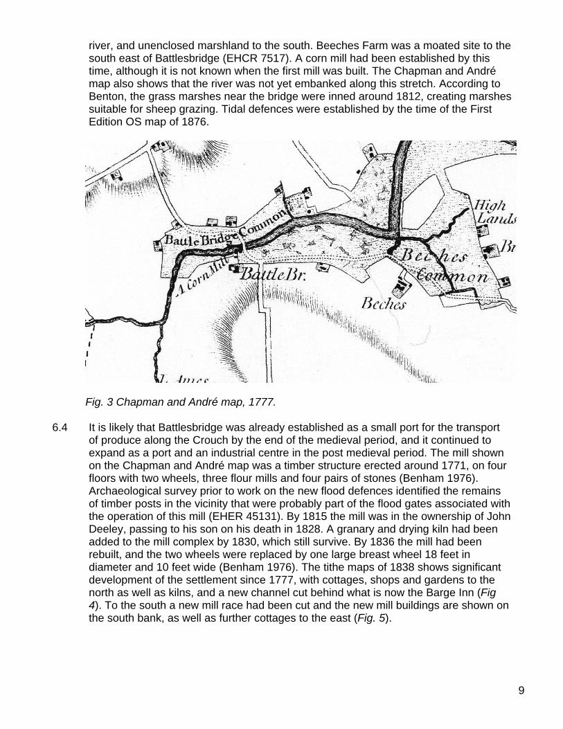
river, and unenclosed marshland to the south. Beeches Farm was a moated site to the south east of Battlesbridge (EHCR 7517). A corn mill had been established by this time, although it is not known when the first mill was built. The Chapman and André map also shows that the river was not yet embanked along this stretch. According to Benton, the grass marshes near the bridge were inned around 1812, creating marshes suitable for sheep grazing. Tidal defences were established by the time of the First Edition OS map of 1876.
Fig. 3 Chapman and André map, 1777.
6.4 It is likely that Battlesbridge was already established as a small port for the transport
of produce along the Crouch by the end of the medieval period, and it continued to expand as a port and an industrial centre in the post medieval period. The mill shown on the Chapman and André map was a timber structure erected around 1771, on four floors with two wheels, three flour mills and four pairs of stones (Benham 1976). Archaeological survey prior to work on the new flood defences identified the remains of timber posts in the vicinity that were probably part of the flood gates associated with the operation of this mill (EHER 45131). By 1815 the mill was in the ownership of John Deeley, passing to his son on his death in 1828. A granary and drying kiln had been added to the mill complex by 1830, which still survive. By 1836 the mill had been rebuilt, and the two wheels were replaced by one large breast wheel 18 feet in diameter and 10 feet wide (Benham 1976). The tithe maps of 1838 shows significant development of the settlement since 1777, with cottages, shops and gardens to the north as well as kilns, and a new channel cut behind what is now the Barge Inn (Fig 4). To the south a new mill race had been cut and the new mill buildings are shown on the south bank, as well as further cottages to the east (Fig. 5).
9
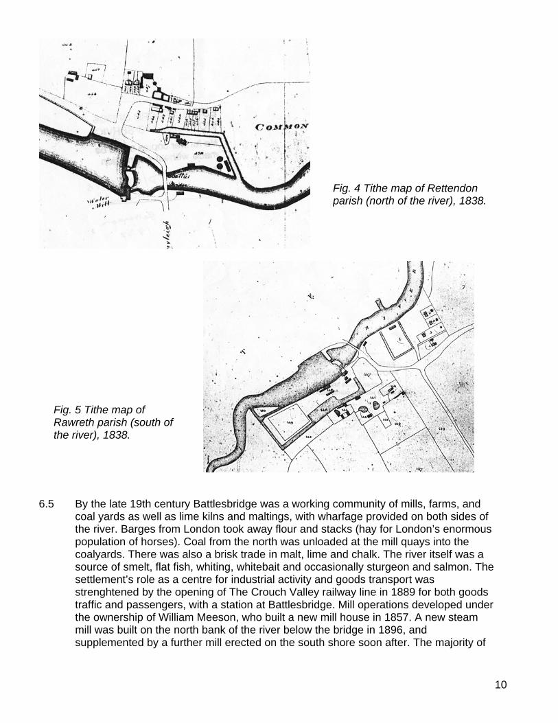
Fig. 4 Tithe map of Rettendon parish (north of the river), 1838.
Fig. 5 Tithe map of Rawreth parish (south of the river), 1838.
6.5 By the late 19th century Battlesbridge was a working community of mills, farms, and
coal yards as well as lime kilns and maltings, with wharfage provided on both sides of the river. Barges from London took away flour and stacks (hay for London’s enormous population of horses). Coal from the north was unloaded at the mill quays into the coalyards. There was also a brisk trade in malt, lime and chalk. The river itself was a source of smelt, flat fish, whiting, whitebait and occasionally sturgeon and salmon. The settlement’s role as a centre for industrial activity and goods transport was strenghtened by the opening of The Crouch Valley railway line in 1889 for both goods traffic and passengers, with a station at Battlesbridge. Mill operations developed under the ownership of William Meeson, who built a new mill house in 1857. A new steam mill was built on the north bank of the river below the bridge in 1896, and supplemented by a further mill erected on the south shore soon after. The majority of
10
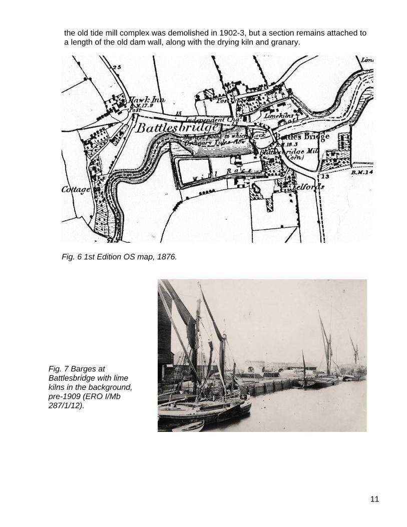
11
the old tide mill complex was demolished in 1902-3, but a section remains attached to a length of the old dam wall, along with the drying kiln and granary.
Fig. 6 1st Edition OS map, 1876.
Fig. 7 Barges at Battlesbridge with lime kilns in the background, pre-1909 (ERO I/Mb 287/1/12).
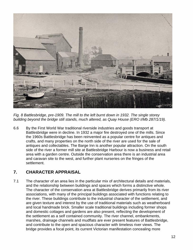
Fig. 8 Battlesbridge, pre-1909. The mill to the left burnt down in 1932. The single storey building beyond the bridge still stands, much altered, as Quay House (ERO I/Mb 287/1/19). 6.6 By the First World War traditional riverside industries and goods transport at
Battlesbridge were in decline. In 1932 a major fire destroyed one of the mills. Since the 1960s Battlesbridge has been reinvented as a popular centre for antiques and crafts, and many properties on the north side of the river are used for the sale of antiques and collectables. The Barge Inn is another popular attraction. On the south side of the river a former mill site at Battlesbridge Harbour is now a business and retail area with a garden centre. Outside the conservation area there is an industrial area and caravan site to the west, and further plant nurseries on the fringes of the settlement.
7. CHARACTER APPRAISAL 7.1 The character of an area lies in the particular mix of architectural details and materials,
and the relationship between buildings and spaces which forms a distinctive whole. The character of the conservation area at Battlesbridge derives primarily from its river associations, with many of the principal buildings associated with functions relating to the river. These buildings contribute to the industrial character of the settlement, and are given texture and interest by the use of traditional materials such as weatherboard and local handmade brick. Smaller scale traditional buildings including former shops and domestic cottages and gardens are also present, reflecting the development of the settlement as a self contained community. The river channel, embankments, marshes, drainage channels and mudflats are ever present features of Battlesbridge, and contribute to the open and spacious character with timeless river views. The bridge provides a focal point, its current Victorian manifestation concealing more
12
13
ancient origins as a major river crossing point. As well as its important position at the head of the tidal river, the rural setting also contributed to the development of Battlesbridge. Agriculture remains an important element in the local economy, and the settlement retains a rural quality both in its architecture and in its green and spacious character.
Spatial Analysis 7.2 The conservation area has
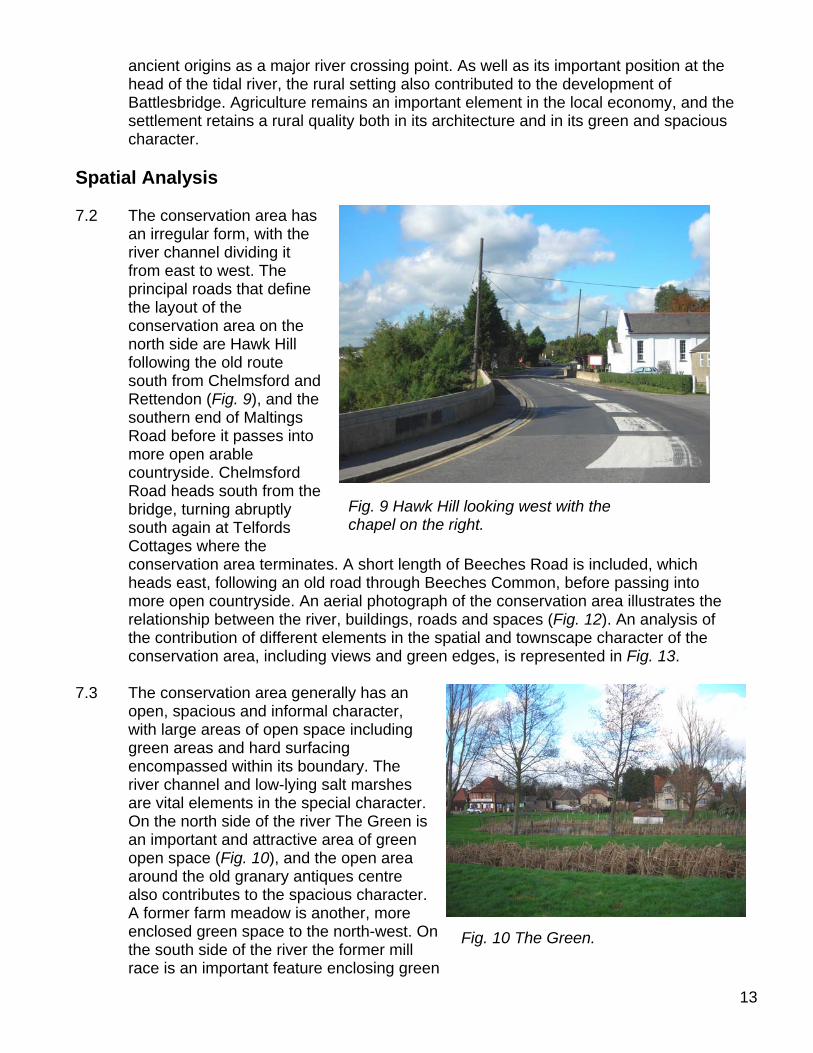
an irregular form, with the river channel dividing it from east to west. The principal roads that define the layout of the conservation area on the north side are Hawk Hill following the old route south from Chelmsford and Rettendon (Fig. 9), and the southern end of Maltings Road before it passes into more open arable countryside. Chelmsford Road heads south from the bridge, turning abruptly south again at Telfords Cottages where the conservation area terminates. A short lengtheads east, following an old road through Beeches Common, before passing into more open countryside. An aerial photograph ofrelationship between the river, buildings, roads and spaces (the contribution of different elements in conservation area, including views
7.3 The conservation area generally has an
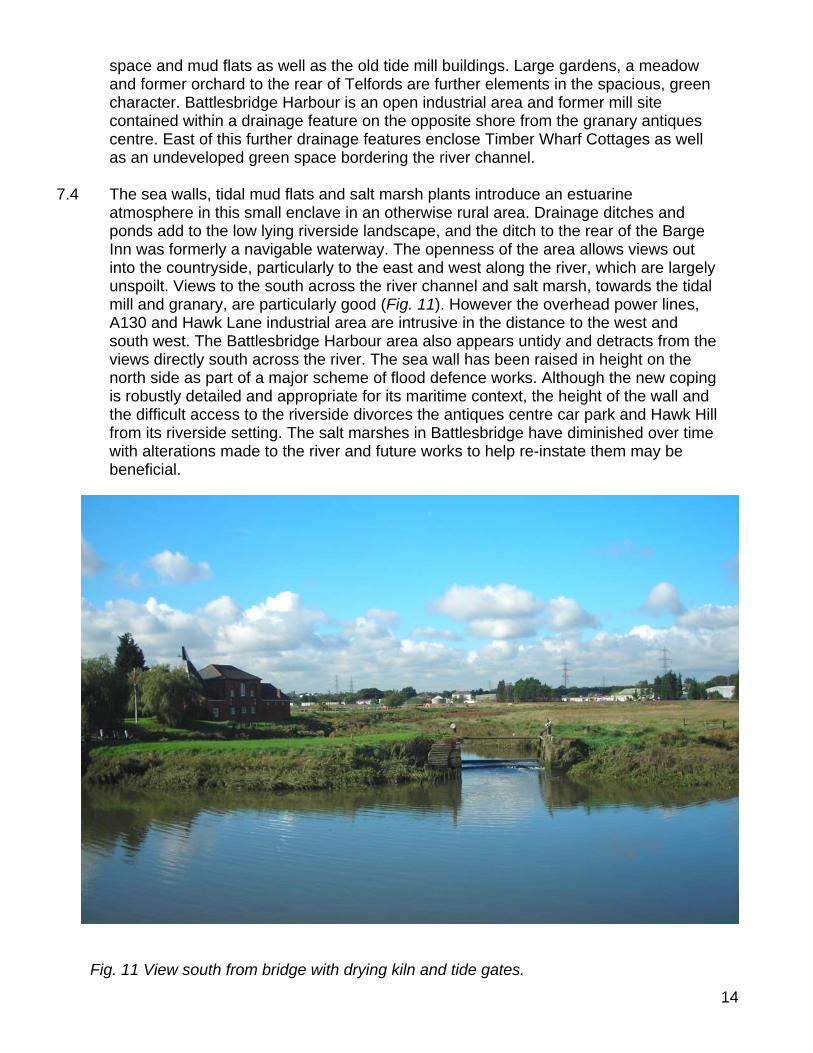
open, spacious and informal character, with large areas of open space including green areas and hard surfacing encompassed within its boundary. The river channel and low-lying salt marshes are vital elements in the special character. On the north side of the river The Green is an important and attractive area of green open space (Fig. 10), and the open area around the old granary antiques centre also contributes to the spacious character. A former farm meadow is another, more enclosed green space to the north-west. On the south side of the river the former mill race is an important feature enclosing green
h of Beeches Road is included, which
the conservation area illustrates the Fig. 12). An analysis of
the spatial and townscape character of the and green edges, is represented in Fig. 13.
Fig. 9 Hawk Hill looking west with the chapel on the right.
Fig. 10 The Green.
14
space and mud flats as well as the old tide mill buildings. Large gardens, a meadow and former orchard to the rear of Telfords are further elements in the spacious, green character. Battlesbridge Harbour is an open industrial area and former mill site contained within a drainage feature on the opposite shore from the granary antiques centre. East of this further drainage features enclose Timber Wharf Cottages as well as an undeveloped green space bordering the river channel.
7.4 The sea walls, tidal mud flats and salt marsh plants introduce an estuarine
atmosphere in this small enclave in an otherwise rural area. Drainage ditches and ponds add to the low lying riverside landscape, and the ditch to the rear of the Barge Inn was formerly a navigable waterway. The openness of the area allows views out into the countryside, particularly to the east and west along the river, which are largely unspoilt. Views to the south across the river channel and salt marsh, towards the tidal mill and granary, are particularly good (Fig. 11). However the overhead power lines, A130 and Hawk Lane industrial area are intrusive in the distance to the west and south west. The Battlesbridge Harbour area also appears untidy and detracts from the views directly south across the river. The sea wall has been raised in height on the north side as part of a major scheme of flood defence works. Although the new coping is robustly detailed and appropriate for its maritime context, the height of the wall and the difficult access to the riverside divorces the antiques centre car park and Hawk Hill from its riverside setting. The salt marshes in Battlesbridge have diminished over time with alterations made to the river and future works to help re-instate them may be beneficial.
Fig. 11 View south from bridge with drying kiln and tide gates.
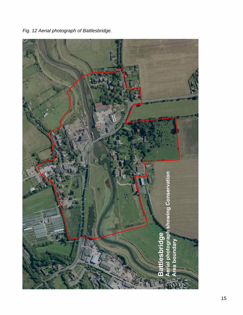
Fig. 12 Aerial photograph of Battlesbridge.
15
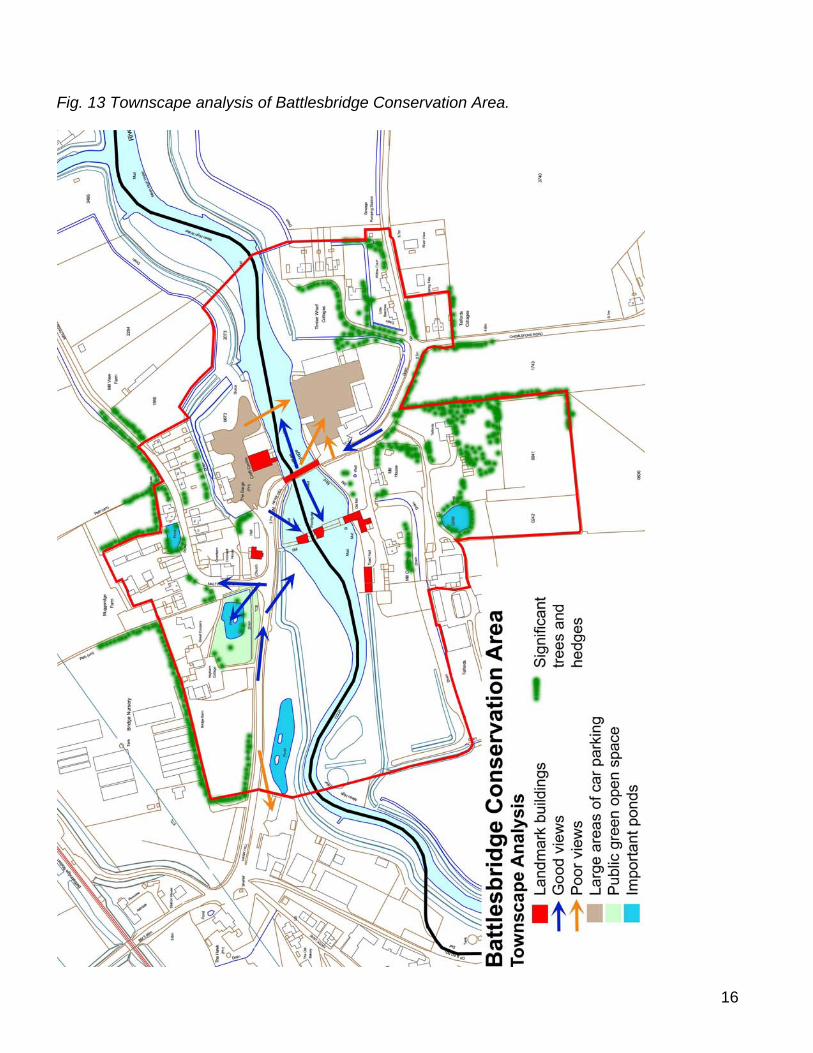
Fig. 13 Townscape analysis of Battlesbridge Conservation Area.
16
17
Character Analysis 7.5 The built environment has a mixed character reflecting its location and historical
development, with industrial buildings, agricultural buildings, small cottages and large houses all contributing to the street scene. The arrangement is loose and informal, with buildings often grouped according to their use or former use, principally industrial, agricultural or domestic. Although few of the non-domestic buildings have retained their original use, the area continues to have a mixed use character, including the antiques centre and associated buildings, public house, hotel, residential, commercial and office buildings. This mix of uses adds significantly to the vitality of the area. One of the most important aspects is the continued riverside activity, with moored barges and boats travelling up the river. The current uses of buildings within the conservation area is represented in Fig. 18.
7.6 The oldest surviving buildings date from the 16th century, and there are a significant
number of 19th century buildings reflecting the success of industrial enterprises at that time. The phased development of the settlement is shown in Fig. 19.
7.7 The north and south sides of the river have their own individual characteristics,
although both are inherently linked by their strong associations with the river. For the purposes of analysis each area is separately covered below. An evaluation of the contribution of individual buildings to the special character of the conservation area is shown in Fig. 20.
Materials and Details 7.8 A varied palette of local traditional
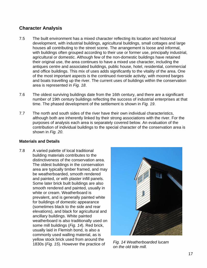
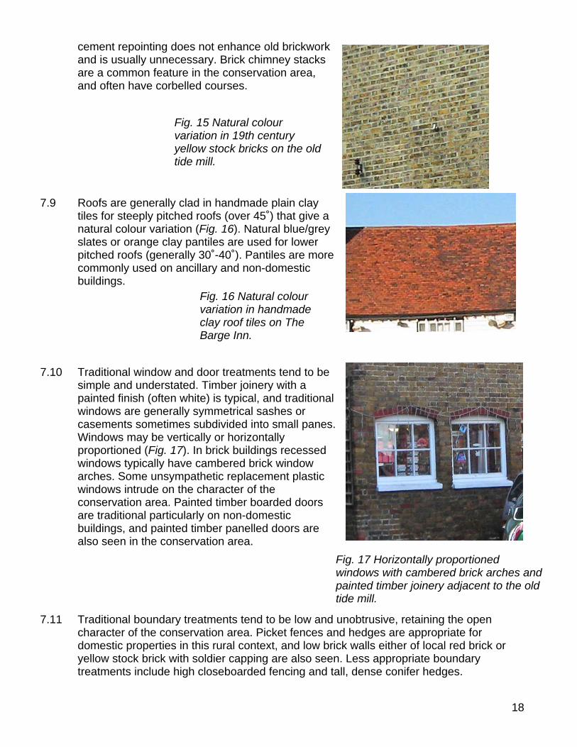
building materials contributes to the distinctiveness of the conservation area. The oldest buildings in the conservation area are typically timber framed, and may be weatherboarded, smooth rendered and painted, or with plaster infill panels. Some later brick built buildings are also smooth rendered and painted, usually in white or cream. Weatherboard is prevalent, and is generally painted white for buildings of domestic appearance (sometimes black to the side and rear elevations), and black for agricultural and ancillary buildings. White painted weatherboard is also traditionally used on some mill buildings (Fig. 14). Red brick, usually laid in Flemish bond, is also a commonly used walling material, as is yellow stock brick used from around the 1830s (Fig. 15). However the practice of Fig. 14 Weatherboarded lucam
on the old tide mill.
18
cement repointing does not enhance old brickwork and is usually unnecessary. Brick chimney stacks are a common feature in the conservation area, and often have corbelled courses.
7.9 Roofs are generally clad in handmade plain clay
tiles for steeply pitched roofs (over 45˚) that give a natural colour variation (Fig. 16). Natural blue/grey slates or orange clay pantiles are used for lower pitched roofs (generally 30˚-40˚). Pantiles are more commonly used on ancillary and non-domestic buildings.
7.10 Traditional window and door treatments tend to be
simple and understated. Timber joinery with a painted finish (often white) is typical, and traditional windows are generally symmetrical sashes or casements sometimes subdivided into small panes. Windows may be vertically or horizontally proportioned (Fig. 17). In brick buildings recessed windows typically have cambered brick window arches. Some unsympathetic replacement plastic windows intrude on the character of the conservation area. Painted timber boarded doors are traditional particularly on non-domestic buildings, and painted timber panelled doors are also seen in the conservation area.
7.11 Traditional boundary treatments tend to be low and unobtrusive, retaining the open
character of the conservation area. Picket fences and hedges are appropriate for domestic properties in this rural context, and low brick walls either of local red brick or yellow stock brick with soldier capping are also seen. Less appropriate boundary treatments include high closeboarded fencing and tall, dense conifer hedges.
Fig. 15 Natural colour variation in 19th century yellow stock bricks on the old tide mill.
Fig. 16 Natural colour variation in handmade clay roof tiles on The Barge Inn.
Fig. 17 Horizontally proportioned windows with cambered brick arches and painted timber joinery adjacent to the old tide mill.
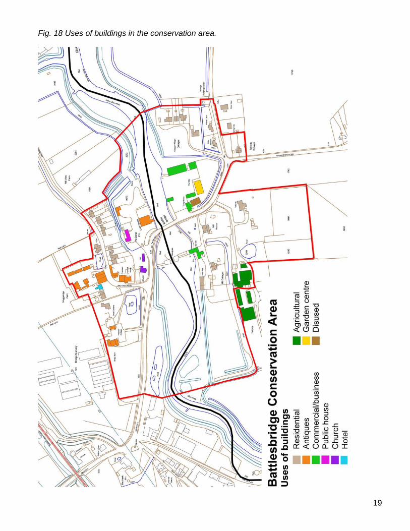
Fig. 18 Uses of buildings in the conservation area.
19
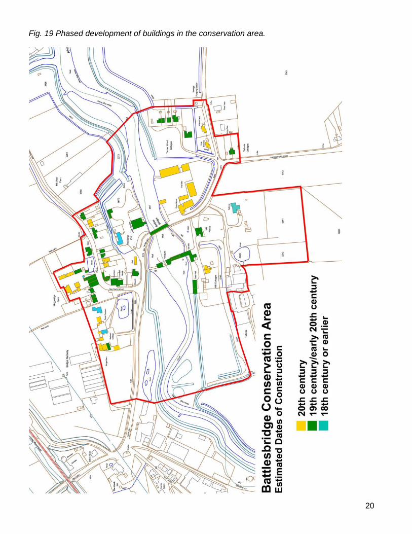
Fig. 19 Phased development of buildings in the conservation area.
20
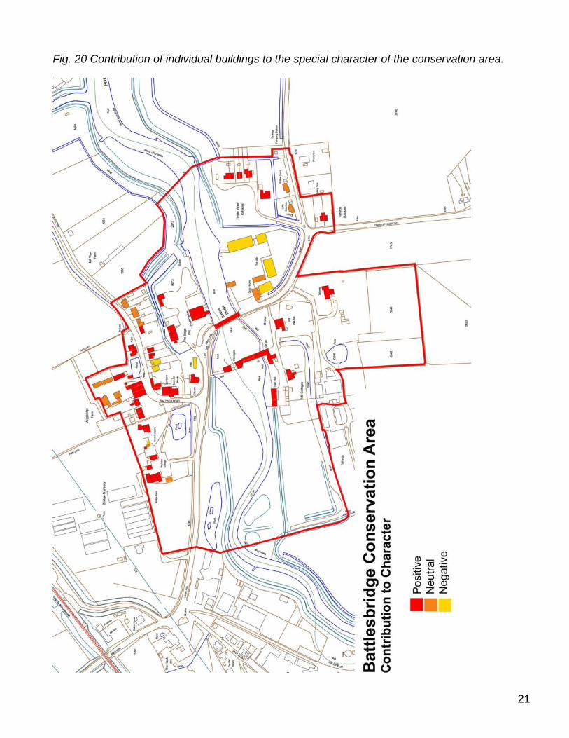
Fig. 20 Contribution of individual buildings to the special character of the conservation area.
21
22
Area 1: North of the River Crouch (Chelmsford Borough) 7.12 The former granary buildings, bridge and river form the heart of the area, with the
antique centre granary as a strong landmark from the surrounding area. The mix of riverside, agricultural and simple residential buildings gives the area a mixed built form which reflects its historic functions. The informal layout of the buildings and modest scale of the cottages to the fringe of the settlement, combined with the presence of many trees adds to the distinctive rural character of the area. For descriptive purposes this area is divided into three sub areas, The Riverside, Hawk Hill and Maltings Road.
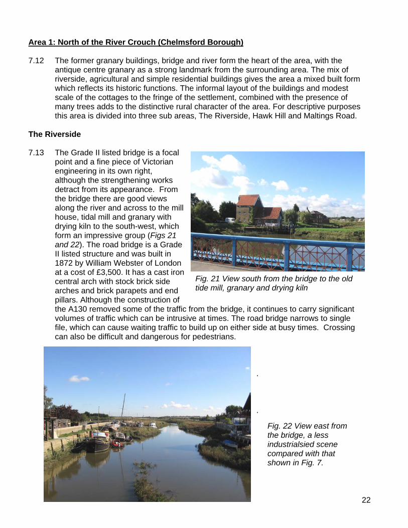
The Riverside 7.13 The Grade II listed bridge is a focal
point and a fine piece of Victorian engineering in its own right, although the strengthening works detract from its appearance. From the bridge there are good views along the river and across to the mill house, tidal mill and granary with drying kiln to the south-west, which form an impressive group (Figs 21 and 22). The road bridge is a Grade
he bridge, it continues to carry significant
up on either side at busy times. Crossing
II listed structure and was built in 1872 by William Webster of London at a cost of £3,500. It has a cast iron central arch with stock brick side arches and brick parapets and end pillars. Although the construction of the A130 removed some of the traffic from tvolumes of traffic which can be intrusive at times. The road bridge narrows to single file, which can cause waiting traffic to buildcan also be difficult and dangerous for pedestrians.
. .
Fig. 21 View south from the bridge to the old tide mill, granary and drying kiln
Fig. 22 View east from the bridge, a less industrialsied scene compared with that shown in Fig. 7.
23
The antique centre granary is the dominant built feature and serves as a reminder of
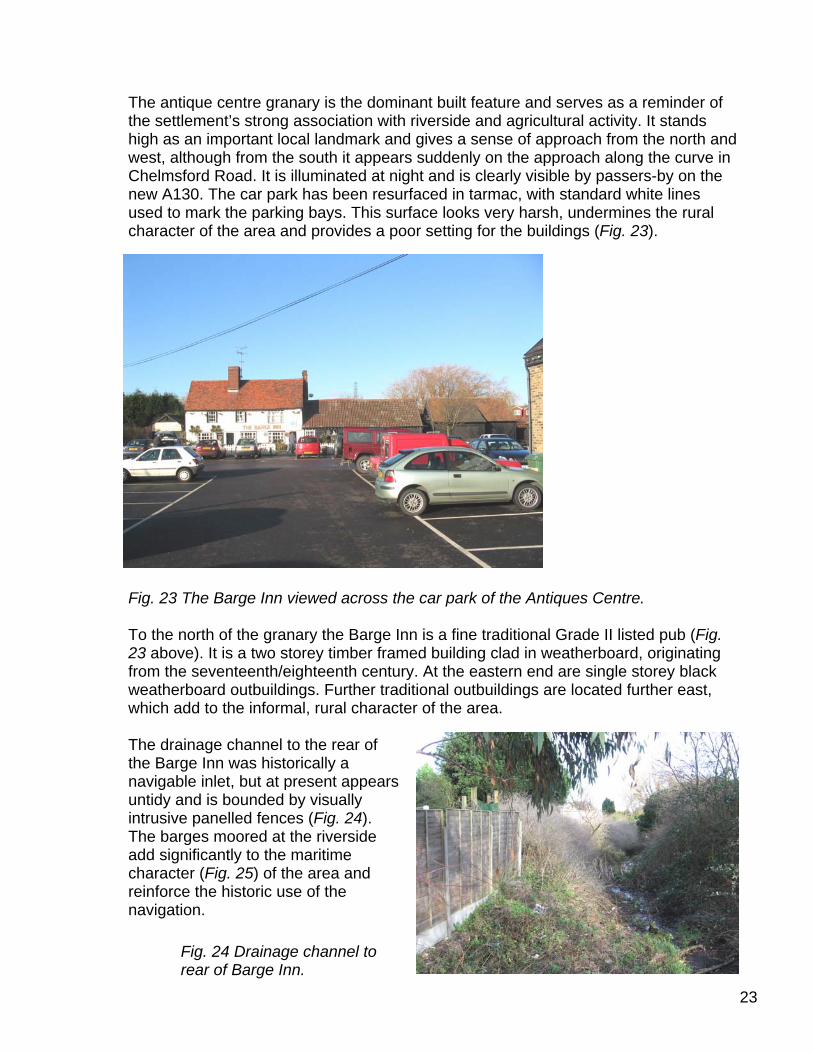
the settlement’s strong association with riverside and agricultural activity. It stands high as an important local landmark and gives a sense of approach from the north and west, although from the south it appears suddenly on the approach along the curve in Chelmsford Road. It is illuminated at night and is clearly visible by passers-by on the new A130. The car park has been resurfaced in tarmac, with standard white lines used to mark the parking bays. This surface looks very harsh, undermines the rural character of the area and provides a poor setting for the buildings (Fig. 23).
Fig. 23 The Barge Inn viewed across To the north of the granary the Barge I
23 above). It is a two storey timber framed from the seventeenth/eighteenth weatherboard outbuildings. Further traditionalwhich add to the informal, rural character of the area.
The drainage channel to the rear of
the Barge Inn was historically a navigable inlet, but at present appears untidy and is bounded by visually intrusive panelled fences (Fig. 24). The barges moored at the riverside add significantly to the maritime character (Fig. 25) of the area and reinforce the historic use of the navigation.
the car park of the Antiques Centre.
nn is a fine traditional Grade II listed pub (Fig. building clad in weatherboard, originating
century. At the eastern end are single storey black outbuildings are located further east,
Fig. 24 Drainage channel to rear of Barge Inn.
24
settlement. Since the A130 and subsequently onsiderably reduced. However the traffic still peak times. The line of conifers along the
alien feature, which is prominent on the crossing. Replacement with a native hedge
d still help to screen the industrial area to
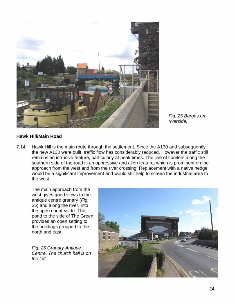
Hawk Hill/Main Road 7.14 Hawk Hill is the main route through the
the new A130 were built, traffic flow has cremains an intrusive feature, particularly atsouthern side of the road is an oppressive and approach from the west and from the river would be a significant improvement and woulthe west.
The main approach from the
west gives good views to the antique centre granary (Fig. 26) and along the river, into the open countryside. The pond to the side of The Green provides an open setting to the buildings grouped to the north and east.
Fig. 26 Granary Antique
Centre. The church hall is on the left.
Fig. 25 Barges on riverside.
25
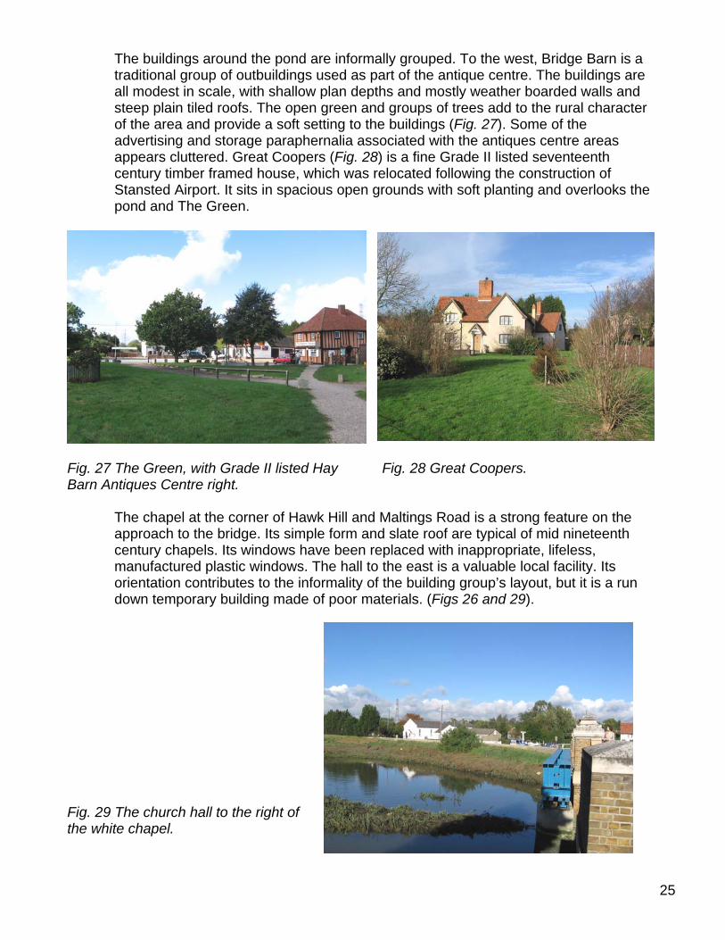
The buildings around the pond are informally grouped. To the west, Bridge Barn is a traditional group of outbuildings used as part of the antique centre. The buildings are all modest in scale, with shallow plan depths and mostly weather boarded walls and steep plain tiled roofs. The open green and groups of trees add to the rural character of the area and provide a soft setting to the buildings (Fig. 27). Some of the advertising and storage paraphernalia associated with the antiques centre areas appears cluttered. Great Coopers (Fig. 28) is a fine Grade II listed seventeenth century timber framed house, which was relocated following the construction of Stansted Airport. It sits in spacious open grounds with soft planting and overlooks the pond and The Green.
Hay Fig. 28 Great Coopers.
Maltings Road is a strong feature on the slate roof are typical of mid nineteenth
eplaced with inappropriate, lifeless, he east is a valuable local facility. Its the building group’s layout, but it is a run
Fig. 27 The Green, with Grade II listed Barn Antiques Centre right. The chapel at the corner of Hawk Hill and
approach to the bridge. Its simple form and century chapels. Its windows have been rmanufactured plastic windows. The hall to torientation contributes to the informality of down temporary building made of poor materials. (Figs 26 and 29).
Fig. 29 The church hall to the right of the white chapel.
26
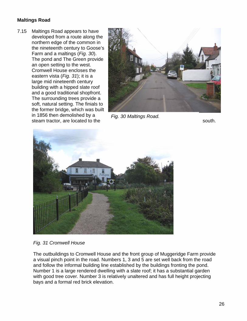
Maltings Road 7.15 Maltings Road appears to have
developed from a route along the northern edge of the common in the nineteenth century to Goose’s Farm and a maltings (Fig. 30). The pond and The Green provide an open setting to the west. Cromwell House encloses the eastern vista (Fig. 31); it is a large mid nineteenth century building with a hipped slate roof and a good traditional shopfront. The surrounding trees provide a soft, natural setting. The finials to the former bridge, which was built in 1856 then demolished by a steam tractor, are located to the south.
Fig. 30 Maltings Road.
Fig. 31 Cromwell House The outbuildings to Cromwell House and the front group of Muggeridge Farm provide
a visual pinch point in the road. Numbers 1, 3 and 5 are set well back from the road and follow the informal building line established by the buildings fronting the pond. Number 1 is a large rendered dwelling with a slate roof; it has a substantial garden with good tree cover. Number 3 is relatively unaltered and has full height projecting bays and a formal red brick elevation.
27
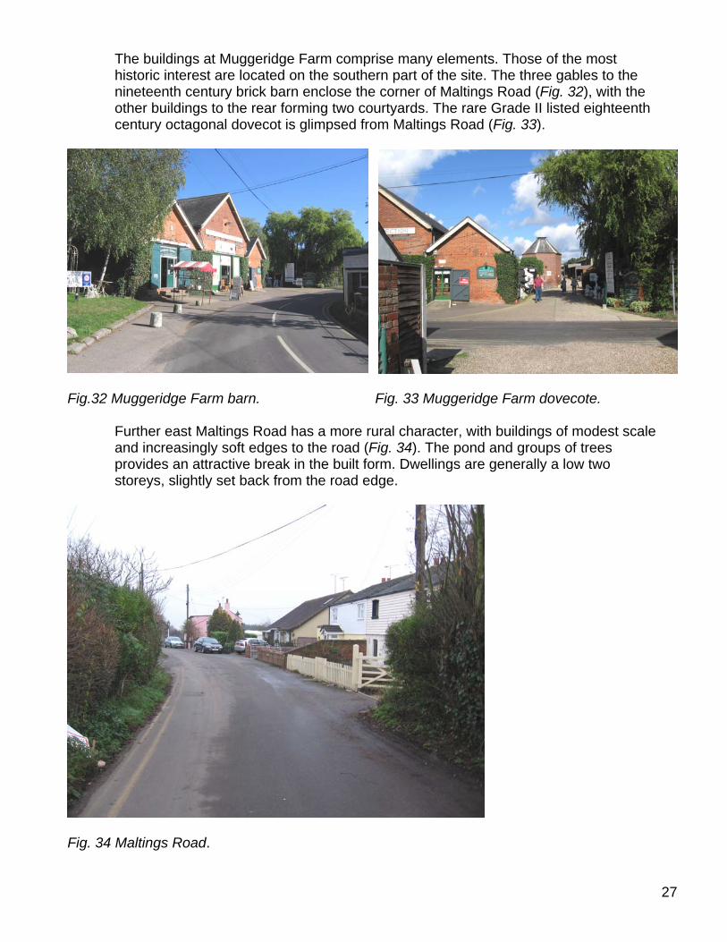
The buildings at Muggeridge Farm comprise many elements. Those of the most historic interest are located on the southern part of the site. The three gables to the nineteenth century brick barn enclose the corner of Maltings Road (Fig. 32), with the other buildings to the rear forming two courtyards. The rare Grade II listed eighteenth century octagonal dovecot is glimpsed from Maltings Road (Fig. 33).
Fig.32 Muggeridge Farm barn. Fig. 33 Muggeridge Farm dovecote. Further east Maltings Road has a more rural character, with buildings of modest scale
and increasingly soft edges to the road (Fig. 34). The pond and groups of trees provides an attractive break in the built form. Dwellings are generally a low two storeys, slightly set back from the road edge.
Fig. 34 Maltings Road.
28
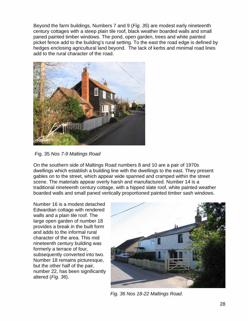
Beyond the farm buildings, Numbers 7 and 9 (Fig. 35) are modest early nineteenth
century cottages with a steep plain tile roof, black weather boarded walls and small paned painted timber windows. The pond, open garden, trees and white painted picket fence add to the building’s rural setting. To the east the road edge is defined by hedges enclosing agricultural land beyond. The lack of kerbs and minimal road lines add to the rural character of the road.
Road numbers 8 and 10 are a pair of 1970s h the dwellings to the east. They present
de spanned and cramped within the street and manufactured. Number 14 is a
a hipped slate roof, white painted weather oportioned painted timber sash windows.
Fig. 35 Nos 7-9 Maltings Road On the southern side of Maltings
dwellings which establish a building line witgables on to the street, which appear wiscene. The materials appear overly harshtraditional nineteenth century cottage, with boarded walls and small paned vertically pr
Number 16 is a modest detached
Edwardian cottage with rendered walls and a plain tile roof. The large open garden of number 18 provides a break in the built form and adds to the informal rural character of the area. This mid nineteenth century building was formerly a terrace of four, subsequently converted into two. Number 18 remains picturesque, but the other half of the pair, number 22, has been significantly altered (Fig. 36).
Fig. 36 Nos 18-22 Maltings Road.
29
Numbers 24 and 26 are bungalows with a very deep plan and dominant low pitched roof, which appear out of scale with the traditional cottages either side. The soft front boundary treatments help to reduce their impact. Beyond, Numbers 28 and 30 are modest cottages with a slate roof, which steps forward where the road gently curves. The large dormer windows and flat roof porches detract from their simple form. To the east good views are available south across the river to Timber Wharf Cottages.
Area 2: South of the River Crouch (Rochford District) 7.16 The old tide mill and associated buildings with their riverside setting are key elements
in the character of the south side of the river, reflecting the industrial past of the settlement. In addition to the historic mill buildings, other wharfside buildings, larger mill owners’ houses and smaller residential properties contribute to the mixed built environment. Trees make a strong contribution to the special character of the area to the south and east, enhancing its rural quality. For descriptive purposes the area is divided into Riverside, Chelmsford Road and Timber Wharf Cottages.
Riverside 7.17 The old tide mill is what
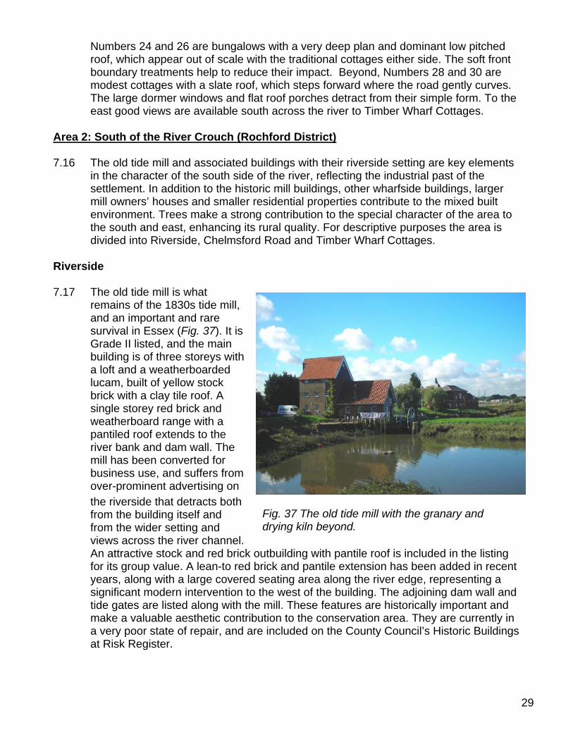
remains of the 1830s tide mill, and an important and rare survival in Essex (Fig. 37). It is Grade II listed, and the main building is of three storeys with a loft and a weatherboarded lucam, built of yellow stock brick with a clay tile roof. A single storey red brick and weatherboard range with a pantiled roof extends to the river bank and dam wall. The mill has been converted for business use, and suffers from over-prominent advertising on the riverside that detracts both from the building itself and from the wider setting and views across the river channel. An attractive stock and red brick outbuilding with pantile roof is included in the listing for its group value. A lean-to red brick and pantile extension has been added in recent years, along with a large covered seating area along the river edge, representing a significant modern intervention to the west of the building. The adjoining dam wall and tide gates are listed along with the mill. These features are historically important and make a valuable aesthetic contribution to the conservation area. They are currently in a very poor state of repair, and are included on the County Council’s Historic Buildings at Risk Register.
Fig. 37 The old tide mill with the granary and drying kiln beyond.
30
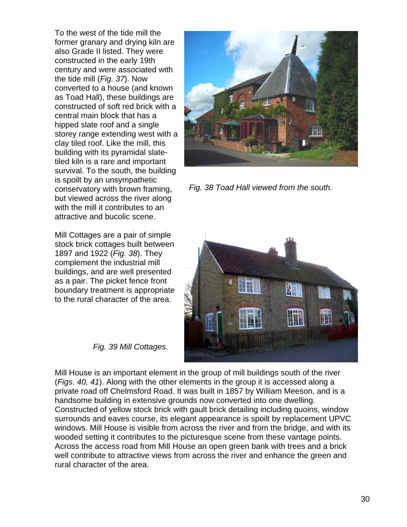
To the west of the tide mill the former granary and drying kiln are also Grade II listed. They were constructed in the early 19th century and were associated with the tide mill (Fig. 37). Now converted to a house (and known as Toad Hall), these buildings are constructed of soft red brick with a central main block that has a hipped slate roof and a single storey range extending west with a clay tiled roof. Like the mill, this building with its pyramidal slate-tiled kiln is a rare and important survival. To the south, the building is spoilt by an unsympathetic conservatory with brown framing, but viewed across the river along with the mill it contributes to an attractive and bucolic scene.
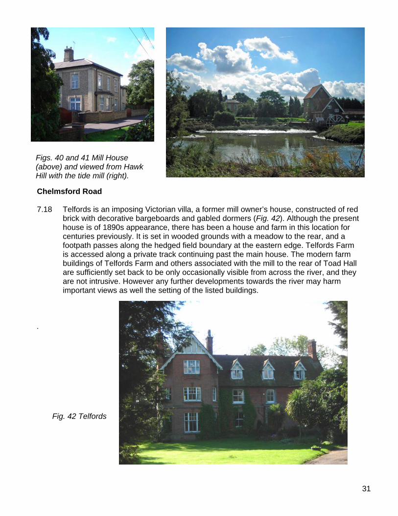
Mill Cottages are a pair of simple
stock brick cottages built between 1897 and 1922 (Fig. 38). They complement the industrial mill buildings, and are well presented as a pair. The picket fence front boundary treatment is appropriate to the rural character of the area.
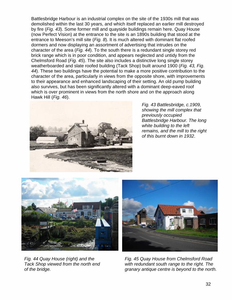
Mill House is an important element in the group of mill buildings south of the river
(Figs. 40, 41). Along with the other elements in the group it is accessed along a private road off Chelmsford Road. It was built in 1857 by William Meeson, and is a handsome building in extensive grounds now converted into one dwelling. Constructed of yellow stock brick with gault brick detailing including quoins, window surrounds and eaves course, its elegant appearance is spoilt by replacement UPVC windows. Mill House is visible from across the river and from the bridge, and with its wooded setting it contributes to the picturesque scene from these vantage points. Across the access road from Mill House an open green bank with trees and a brick well contribute to attractive views from across the river and enhance the green and rural character of the area.
Fig. 38 Toad Hall viewed from the south.
Fig. 39 Mill Cottages.
31
Chelmsford Road 7.18
important views as well the se . Fig. 42 Telfords
Figs. 40 and 41 Mill House (above) and viewed from Hawk Hill with the tide mill (right).
Telfords is an imposing Victorian villa, a former mill owner’s house, constructed of red brick with decorative bargeboards and gabled dormers (Fig. 42). Although the present house is of 1890s appearance, there has been a house and farm in this location for centuries previously. It is set in wooded grounds with a meadow to the rear, and a footpath passes along the hedged field boundary at the eastern edge. Telfords Farm is accessed along a private track continuing past the main house. The modern farm buildings of Telfords Farm and others associated with the mill to the rear of Toad Hall are sufficiently set back to be only occasionally visible from across the river, and they are not intrusive. However any further developments towards the river may harm
tting of the listed buildings.
32
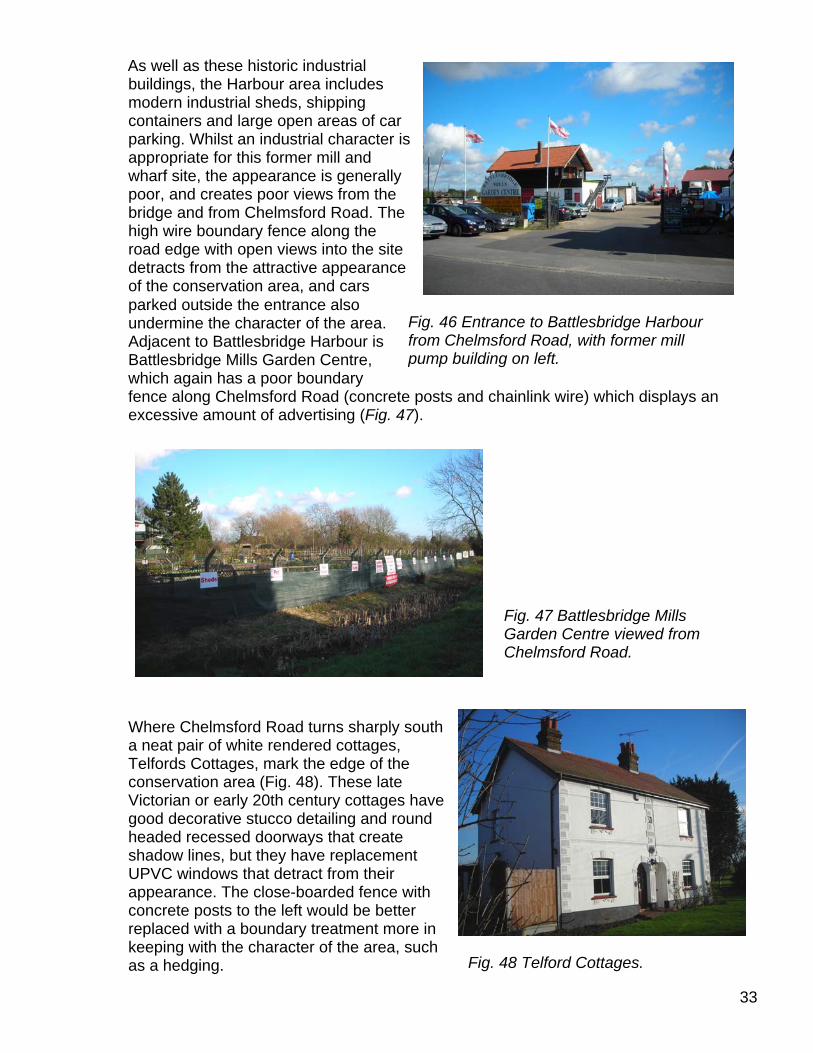
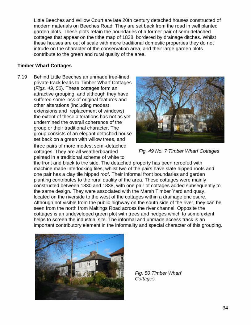
Battlesbridge Harbour is an industrial complex on the site of the 1930s mill that was demolished within the last 30 years, and which itself replaced an earlier mill destroyed by fire (Fig. 43). Some former mill and quayside buildings remain here. Quay House (now Perfect Vision) at the entrance to the site is an 1890s building that stood at the entrance to Meeson’s mill site (Fig. 8). It is much altered with dominant flat roofed dormers and now displaying an assortment of advertising that intrudes on the character of the area (Fig. 44). To the south there is a redundant single storey red brick range which is in poor condition, and appears neglected and untidy from the Chelmsford Road (Fig. 45). The site also includes a distinctive long single storey weatherboarded and slate roofed building (Tack Shop) built around 1900 (Fig. 43, Fig. 44). These two buildings have the potential to make a more positive contribution to the character of the area, particularly in views from the opposite shore, with improvements to their appearance and enhanced landscaping of their setting. An old pump building also survives, but has been significantly altered with a dominant deep-eaved roof which is over prominent in views from the north shore and on the approach along Hawk Hill (Fig. 46).
Fig. 43 Battlesbridge, c.1909, showing the mill complex that previously occupied Battlesbridge Harbour. The long white building to the left remains, and the mill to the right of this burnt down in 1932.
Fig. 44 Quay House (right) and the Tack Shop viewed from the north end of the bridge.
Fig. 45 Quay House from Chelmsford Road with redundant south range to the right. The granary antique centre is beyond to the north.
33
As well as these historic industrial buildings, the Harbour area includes modern industrial sheds, shipping containers and large open areas of car parking. Whilst an industrial character is appropriate for this former mill and wharf site, the appearance is generally poor, and creates poor views from the bridge and from Chelmsford Road. The high wire boundary fence along the road edge with open views into the site
Where Chelmsford Road turns sharply south
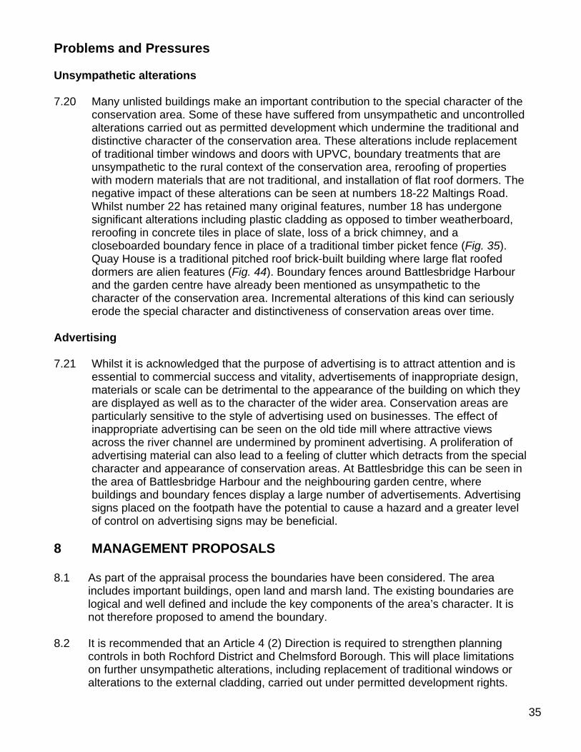
a neat pair of white rendered cottages, Telfords Cottages, mark the edge of the conservation area (Fig. 48). These late Victorian or early 20th century cottages have good decorative stucco detailing and round headed recessed doorways that create shadow lines, but they have replacement UPVC windows that detract from their appearance. The close-boarded fence with concrete posts to the left would be better replaced with a boundary treatment more in keeping with the character of the area, such as a hedging.
detracts from the attractive appearance of the conservation area, and cars parked outside the entrance also undermine the character of the area. Adjacent to Battlesbridge Harbour is Battlesbridge Mills Garden Centre, which again has a poor boundary fence along Chelmsford Road (concrete posts and chainlink wire) which displays an excessive amount of advertising (Fig. 47).
Fig. 46 Entrance to Battlesbridge Harbour from Chelmsford Road, with former mill pump building on left.
Fig. 47 Battlesbridge Mills Garden Centre viewed from Chelmsford Road.
Fig. 48 Telford Cottages.
34
Little Beeches and Willow Court are late 20th century detached houses constructed of modern materials on Beeches Road. They are set back from the road in well planted garden plots. These plots retain the boundaries of a former pair of semi-detached cottages that appear on the tithe map of 1838, bordered by drainage ditches. Whilst these houses are out of scale with more traditional domestic properties they do not intrude on the character of the conservation area, and their large garden plots contribute to the green and rural quality of the area.
Timber Wharf Cottages 7.19 Behind Little Beeches an unmade tree-lined
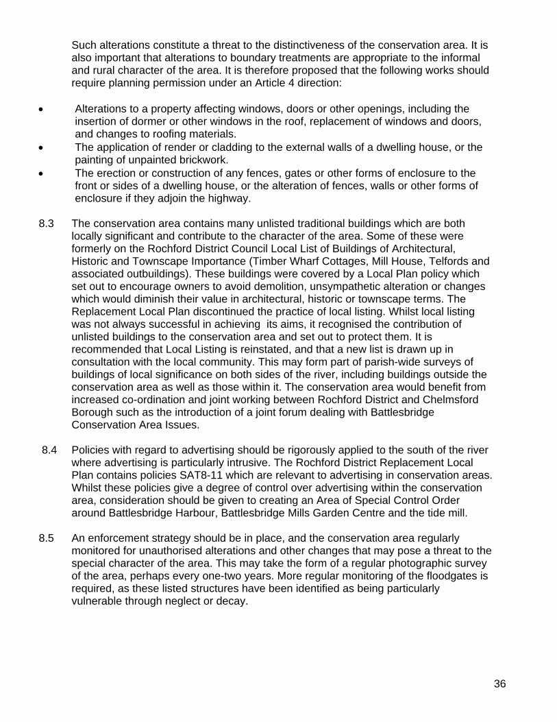
private track leads to Timber Wharf Cottages (Figs. 49, 50). These cottages form an attractive grouping, and although they have suffered some loss of original features and other alterations (including modest extensions and replacement of windows) the extent of these alterations has not as yet undermined the overall coherence of the group or their traditional character. The group consists of an elegant detached house set back on a green with willow trees, and three pairs of more modest semi-detached cottages. They are all weatherboarded painted in a traditional scheme of white to the front and black to the side. The detached property has been reroofed with machine made interlocking tiles, whilst two of the pairs have slate hipped roofs and one pair has a clay tile hipped roof. Their informal front boundaries and garden planting contributes to the rural quality of the area. These cottages were mainly constructed between 1830 and 1838, with one pair of cottages added subsequently to the same design. They were associated with the Marsh Timber Yard and quay, located on the riverside to the west of the cottages within a drainage enclosure. Although not visible from the public highway on the south side of the river, they can be seen from the north from Maltings Road across the river channel. Opposite the cottages is an undeveloped green plot with trees and hedges which to some extent helps to screen the industrial site. The informal and unmade access track is an important contributory element in the informality and special character of this grouping.
Fig. 49 No. 7 Timber Wharf Cottages
Fig. 50 Timber Wharf Cottages.
Problems and Pressures Unsympathetic alterations 7.20 Many unlisted buildings make an important contribution to the special character of the
conservation area. Some of these have suffered from unsympathetic and uncontrolled alterations carried out as permitted development which undermine the traditional and distinctive character of the conservation area. These alterations include replacement of traditional timber windows and doors with UPVC, boundary treatments that are unsympathetic to the rural context of the conservation area, reroofing of properties with modern materials that are not traditional, and installation of flat roof dormers. The negative impact of these alterations can be seen at numbers 18-22 Maltings Road. Whilst number 22 has retained many original features, number 18 has undergone significant alterations including plastic cladding as opposed to timber weatherboard, reroofing in concrete tiles in place of slate, loss of a brick chimney, and a closeboarded boundary fence in place of a traditional timber picket fence (Fig. 35). Quay House is a traditional pitched roof brick-built building where large flat roofed dormers are alien features (Fig. 44). Boundary fences around Battlesbridge Harbour and the garden centre have already been mentioned as unsympathetic to the character of the conservation area. Incremental alterations of this kind can seriously erode the special character and distinctiveness of conservation areas over time.
Advertising 7.21 Whilst it is acknowledged that the purpose of advertising is to attract attention and is
essential to commercial success and vitality, advertisements of inappropriate design, materials or scale can be detrimental to the appearance of the building on which they are displayed as well as to the character of the wider area. Conservation areas are particularly sensitive to the style of advertising used on businesses. The effect of inappropriate advertising can be seen on the old tide mill where attractive views across the river channel are undermined by prominent advertising. A proliferation of advertising material can also lead to a feeling of clutter which detracts from the special character and appearance of conservation areas. At Battlesbridge this can be seen in the area of Battlesbridge Harbour and the neighbouring garden centre, where buildings and boundary fences display a large number of advertisements. Advertising signs placed on the footpath have the potential to cause a hazard and a greater level of control on advertising signs may be beneficial.
8 MANAGEMENT PROPOSALS 8.1 As part of the appraisal process the boundaries have been considered. The area
includes important buildings, open land and marsh land. The existing boundaries are logical and well defined and include the key components of the area’s character. It is not therefore proposed to amend the boundary.
8.2 It is recommended that an Article 4 (2) Direction is required to strengthen planning
controls in both Rochford District and Chelmsford Borough. This will place limitations on further unsympathetic alterations, including replacement of traditional windows or alterations to the external cladding, carried out under permitted development rights.
35
Such alterations constitute a threat to the distinctiveness of the conservation area. It is also important that alterations to boundary treatments are appropriate to the informal and rural character of the area. It is therefore proposed that the following works should require planning permission under an Article 4 direction:
• Alterations to a property affecting windows, doors or other openings, including the
insertion of dormer or other windows in the roof, replacement of windows and doors, and changes to roofing materials.
• The application of render or cladding to the external walls of a dwelling house, or the painting of unpainted brickwork.
• The erection or construction of any fences, gates or other forms of enclosure to the front or sides of a dwelling house, or the alteration of fences, walls or other forms of enclosure if they adjoin the highway.
8.3 The conservation area contains many unlisted traditional buildings which are both
locally significant and contribute to the character of the area. Some of these were formerly on the Rochford District Council Local List of Buildings of Architectural, Historic and Townscape Importance (Timber Wharf Cottages, Mill House, Telfords and associated outbuildings). These buildings were covered by a Local Plan policy which set out to encourage owners to avoid demolition, unsympathetic alteration or changes which would diminish their value in architectural, historic or townscape terms. The Replacement Local Plan discontinued the practice of local listing. Whilst local listing was not always successful in achieving its aims, it recognised the contribution of unlisted buildings to the conservation area and set out to protect them. It is recommended that Local Listing is reinstated, and that a new list is drawn up in consultation with the local community. This may form part of parish-wide surveys of buildings of local significance on both sides of the river, including buildings outside the conservation area as well as those within it. The conservation area would benefit from increased co-ordination and joint working between Rochford District and Chelmsford Borough such as the introduction of a joint forum dealing with Battlesbridge Conservation Area Issues.
8.4 Policies with regard to advertising should be rigorously applied to the south of the river
where advertising is particularly intrusive. The Rochford District Replacement Local Plan contains policies SAT8-11 which are relevant to advertising in conservation areas. Whilst these policies give a degree of control over advertising within the conservation area, consideration should be given to creating an Area of Special Control Order around Battlesbridge Harbour, Battlesbridge Mills Garden Centre and the tide mill.
8.5 An enforcement strategy should be in place, and the conservation area regularly
monitored for unauthorised alterations and other changes that may pose a threat to the special character of the area. This may take the form of a regular photographic survey of the area, perhaps every one-two years. More regular monitoring of the floodgates is required, as these listed structures have been identified as being particularly vulnerable through neglect or decay.
36
Enhancement Opportunities 8.6 Various opportunities exist to enhance the character of the conservation area. Some
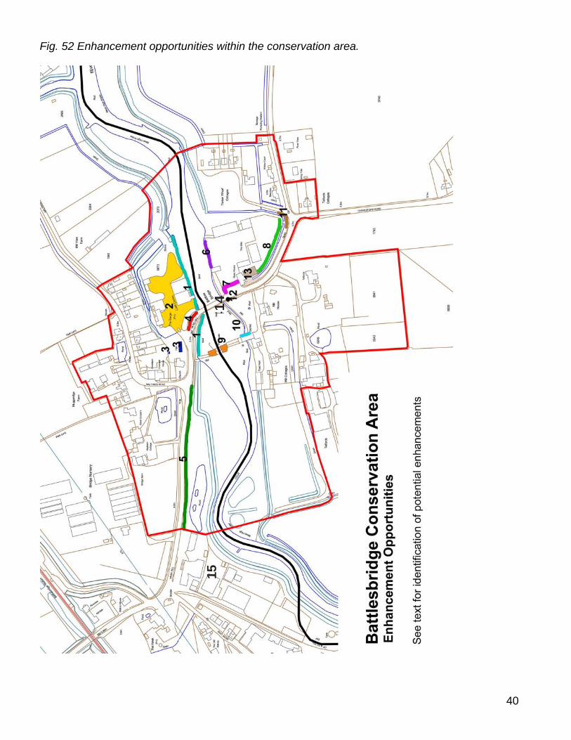
of these will only be possible over the long term, for example as Highways improvements are made or as and when opportunities arise during the course of other works. Others may be implemented more quickly by the local authority once this appraisal has been adopted, for example reviewing intrusive advertising. Funding opportunities will need to be identified for many of these proposals, such as community funding or landscape improvement grants. The following enhancement opportunities are indicated on the map below (Fig. 52).
1. The river is a strong feature and the heart of the conservation area. At present public
access to the riverside is limited and the visual link with the river eroded by the sea wall. Improved access to appreciate the river would be a significant enhancement. Improved landscaping, access and seating on the northern side, between the bridge and granary is one area with potential which could be achieved by Chelmsford Borough Council working with the Environment Agency. The sea wall South of the river between Battlesbridge and Hullbridge also offers potential for enhancement and improved access would benefit local residents and help attract tourists. Public consultation highlighted siltation of the river as a potential problem and that regular dredging of the river may be beneficial.
2. The car park of the antiques centre has been surfaced in tarmac, with standard white line markings, which gives a harsh and urban appearance. Chelmsford Borough Council should encourage the landowner when resurfacing is required to use a surface treatment which gives a textured, natural, semi rural appearance, such as bound shingle, with subtle markings.
3. The church hall is an important local facility in a prominent position, but is a prefabricated building which is now in a poor condition. Replacement with a new structure using good quality materials would be desirable, and community funding should be sought by the church authorities for this with the support of Chelmsford Borough Council. Removal of the storage container to the rear and improvement to the church windows could also form part of this scheme.
4. The main approach to the bridge on the northern side is cluttered with signs at present. Rationalisation of these signs would improve the setting of the bridge and granary and approach to the river’s edge. Where stone kerbstones have survived along Hawk Hill (not marked on map) these should be retained and reinstated where they have been lost, in preference to concrete kerbs which have a flat and lifeless appearance in comparison. This will require the co-operation of Essex County Council Highways team and Chelmsford Borough Council.
5. The conifer trees on the main approach from the west along Hawk Hill are an alien and oppressive feature. Chelmsford Borough Council should encourage the landowner to replace these with a native hedge, such as hawthorn, which would be a vast improvement to the conservation area.
6. The southern riverbank is quite prominent in views south from the area around the antiques centre and from the bridge itself. However the Battlesbridge Harbour area appears untidy and detracts from these views. Opportunities to enhance the appearance of this area should be sought by Rochford District Council working with the landowner, either through improvements made within the site itself or through
37

screening, with native hedging and tree planting for example. Tamarisk bushes are an estuarine species and would be suitable for planting on the riverside.
7. Battlesbridge Harbour is also untidy viewed from the Chelmsford Road, and would benefit from an improved boundary treatment and screening, less cluttered advertising and a more attractively landscaped entrance. Rochford District Council should encourage the landowner to undertake these improvements.
8. The garden centre is prominent along the Chelmsford Road, but has a poor boundary fence which could be replaced with a more appropriate boundary treatment appropriate for the rural context of the conservation area such as timber post and rail or native hedging, as well as rationalisation of the advertising. The drainage ditch running along the road edge here is also untidy. Rochford District Council should encourage the landowner to make improvements here.
9. The lock gates are currently in a very poor condition and are on the County Council’s buildings at risk register. These gates are both historically important and a vital element in the attractive views across the river channel to the old mill. The landowner should be encouraged to repair these structures by Rochford District Council.
10. The old tide mill frequently has unauthorised advertisements which are intrusive in views across the river. This should be monitored, with formal action being taken where necessary, and Rochford District Council should work with the owner to ensure advertising is appropriate for this highly sensitive location.
11. Approaching the conservation area from the south along Chelmsford Road the road edge on the prominent bend west is cluttered with signage and old street furniture. Rationalisation and replacement with more sensitively designed signs would enhance the appearance of the conservation area, and this will require the cooperation of Rochford District Council and Essex County Council Highways team (Fig. 51). In addition if Highways works are carried out replacement of concrete kerbstones with natural stone would enhance the appearance of the public realm.
Fig. 51 Street signs and furniture, Chelmsford Road. 12. There is a redundant traffic sign post on the south side of the bridge which should be
removed by Essex County Council Highways team. 13. A redundant industrial building along the Chelmsford Road currently detracts from the
appearance of the conservation area, and has an untidy verge. Rochford District
38
Council should work with the owner to seek the repair and reuse of this building or replacement with an appropriate building of good quality design and materials. In conjunction with this the grass verge and area to the roadside of Quay House should be tidied and improved.
14. The pinch part created by the bridge causes traffic to back up and makes pedestrian routes uncomfortable and crossing dangerous. The options for improving traffic flow and safe pedestrian crossing could be considered by Essex County Council, with input from Chelmsford Borough and Rochford District Council’s.
15. The industrial area to the east, lies beyond the conservation area boundary but detracts from its setting. Opportunities for improvements to its appearance and screening should be considered.
16. Street furniture within the area is minimal, but of variable quality. A high quality coordinated range of lamp posts, bins, benches etc. would enhance the quality of the public realm.
39
40
Fig. 52 Enhancement opportunities within the conservation area.
14 415
BIBLIOGRAPHY Alderton, D. and Booker, J. 1980 The Batsford Guide to Industrial Archaeology of East Anglia, London: B.T. Batsford Ltd Benham, H. 1976 Some Essex Water Mills, Colchester: Essex County Newspapers Ltd Benton, P. 1888 The History of Rochford Hundred, Rawreth, Rochford: A. Harrington Blandford Associates. 2006. Landscape character assessments. Booker, J. 1974 Essex and the Industrial Revolution, Chelmsford: Essex County Council Heppell, E. Battlesbridge Tidal Defences, Essex Archaeological Survey, Essex County Council: unpublished report Newman, L.T. 1970 History of Battlesbridge, The Parish of Rawreth II, Local History Studies RCHME 1923 Royal Commission on Historical Monuments (England) An inventory of the historical monuments in Essex, London: HMSO Reaney, P.H. 1935 Place-names in Essex, Cambridge Reidy, K. 1993 A130 By-pass Stage II (A27-A132) Desktop Assessment, Essex County Council: unpublished report Rochford District Historic Environment Characterisation Project Report 2005, Essex County Council/Rochford District Council, unpublished report
41
APPENDIX 1 Listed Buildings in the conservation area Copies of the list descriptions for the all the listed buildings within the conservation
area are reproduced below. It should be noted that listed building protection covers all parts of the structure, internally and externally, and for any structure pre dating 1st July 1948 within its curtilage.
Battlesbridge, Chelmsford Road TQ 79 SE 21/950 II Road bridge crossing the tidal River Crouch. Circa 1872. William Webster, St. Martin's
Place, Trafalgar Square, London, at a cost of £3,500. Cast iron centre arch, gault brick side arches with brick parapets and end pillars. The centre ribbed arch of 47 feet has a cast iron panelled face to east with 5 foliated tie bosses and trellised cast iron parapet with moulded rail. Side arches each of 20 feet with brick rusticated keystones and moulded bases. Moulded band over arch, chamfered coping. The central pillars with moulded heads,end pillars with chamfered heads. Rounded cut waters. Total length of bridge 117 feet. Records of bridges on this site date to 1372. The previous bridge c1845 by Thos.Hopper was demolished by a steam traction engine thus the specification for this bridge was stringent. "Composed of best soft grey metal. The whole of the girders to be put together in the yard and proved in the presence of the architect at the contractor's risk with a hydraulic ram, with the following weights in the centre ... each external girder proved with a weight of 16 tons in the centre with a clear bearing of 47 feet. Each girder to return at once to its original form after proof and to remain without permanent set." The bridge had a clear width between parapets of 18 feet and for over 100 years carried all road traffic across the River Crouch. During the past few years, the bridge has been widened to the west face to accommodate 2 lane traffic. The original finials are now erected in front of Cromwell House, Rettendon, to the north west of the bridge. Local History studies. Leslie T Newman. Batsford Guide to Industrial Archaeology in East Anglia. J Booker. The southern part of this bridge is in the District of Rochford.
Hay Barn Antique Centre, Main Road TQ 79 SE 21/584 II A C16 timber-framed building restored in the C20, with exposed timber-framing and
plaster infill. 2 storeys. Casement windows with leaded lights. Roof tiled, hipped.
42
Barge Inn, Main Road TQ 79 SE 21/808 II A C17-C18 timber-framed and weatherboarded building, 2 storeys. 3 window range,
mainly double-hung sashes with glazing bars. The ground storey windows are 3 light. Plain doorways. Roof tiled, with a large, red brick chimney stack. The interior has exposed ceiling beams and joists.
Dovecot at Muggeridge’s Farm, Maltings Road TQ 79 SE 21/809 II Cl8 or early C19 red brick octagonal dovecote doorway set in a semi-circular arched
recess, there are bulls eye windows on 3 sides. Roof slate, with oversailing brick eaves courses.
Coopers Farmhouse, The Green
TQ 79 SE 21/951 II Farmhouse, now house. Early C17 crosswing and brewhouse - bakehouse to rear,
connected by early/mid C19 bay; late C17/early C18 wing added to left of crosswing. Render over brick and timber frame; gabled old tile roofs; C17 brick ridge and end stacks finished in C20 brick. L-plan with rear right wing. One storey and attic; 2-window range. Mid C19 bracketed gabled hood over 4-panelled central door; segmental arches over 3-light wood casements, some of which are mid/late C19; large mid C19 gabled dormer to left. Late C17/early gabled wing to rear left. One storey bakehouse to rear, with weatherboard over timber frame and C20 door and wood casements. Interior: exposed timber frame. Cross-wing to right has chamfered beam and C17 window opening to rear and open fireplace and stop-chamfered beam and joists; stop -chamfered beams and joists to left; jowled storey posts to cellar trusses, exposed at first floor level, with C17 four-light wood-mullioned window to rear. Brewhouse/bakehouse to rear, of 2 bays, has exposed timber frame with C17 wood- mullioned window to rear; straight-bracing to tie beams of reconstructed roof; bay to left has timber lintel over large open fireplace with bread oven; floored end to right has quarter-turn staircase with solid treads. This house was moved from its original site at Coopers End, Takeley, following the expansion of Stanstead Airport.
43
44
APPENDIX 2 EHER sites in the conservation area EHER number Monument Description 7607 Moat (dated 1066AD to
1539AD/Embankment Possible moat at Battlesbridge Mill. Enclosure west of road is shown as mill race on OS 25”. East of the road it encloses four pairs of cottages and is a drainage feature.
7608 Mill race/drainage ditch Enclosure west of road is shown as a mill race on OS 25”. Possible moated site here once.
7671 Silver mirror found in River Crouch by metal detector user, 1979.
20145 Demolition chamber Mining chamber at the Weir. Approx. 80 yards west of the road bridge are the remains of an earthen and concrete barrier across the River Crouch. This once had lock gates, now gone, and a water wheel, still extant. Although now crumbling and partly collapsing, aerial photographs from 1960 show this to have once been a sophisticated structure across the river. It is not known where the chambers might have been located. Although presumed to be demolished, it is possible that they still remain within the surviving portion of the structure.
45131 Tidal defences Posts found in the river silts of the River Crouch are probably associated with the floodgates and water management system linked to the mill to the west. It would therefore seem likely that they are post-medieval in date.
45


Recommended