Xfmmjohupo!Sfhjpobm!Mboetdbqf!Bumbt29!Nbz!311:

Xfmmjohupo!Sfhjpo!Mboetdbqf!Bumbt
1
3
1 DPOU FOU T 12 Jouspevdujpo
13 Nbq!Bumbt Topography and Topography Analysis Upqphsbqiz! ! ! ! ! ! ! ! ! !:! ! Fmfwbujpo! ! ! ! ! ! ! ! ! ! 22!! ! Tmpqf ! ! ! ! ! ! ! ! ! ! 24! !
Landform! ! Hfpmphz!.!RNBQ!! ! ! ! ! ! ! ! 32
! ! Hfpmphz!.!Hfpqsftfswbujpo!Jowfoupsz! ! ! ! ! 34! ! Mboegpsn !)MFO[*! ! ! ! ! ! ! ! 42
Landcover ! !! ! Mboedpwfs!)O[!Mboetdbqf !Dmbttjg jdbujpo*! ! ! ! 44! ! Mboedpwfs!)MDEC2w3*!! ! ! ! ! ! ! 46
! ! Dbudinfout!! ! ! ! ! ! ! ! ! 54!
Landuse ! !! ! Qvcmjd !Mboe! ! ! ! ! ! ! ! ! 56! ! Vscbo!Bsfbt!0!Sfhjpobm!Jogsbtusvduvsf !! ! ! ! 58
! ! Ifsjubhf! ! ! ! ! ! ! ! ! ! 59
Composi te Analysis/Landscape Management !! ! MFO[!Mfwfm!J !Fowjsponfout! ! ! ! ! ! ! 68! ! Fowjsponfoubm!Nbobhfnfou! ! ! ! ! ! 6:! ! O[MSJ!. !Mboe!Vtf !Dbqbcjm juz!)NMVD*! ! ! ! ! 78! ! Fdpepnbjot! ! ! ! ! ! ! ! ! 86! ! Tjhojgjdbou!Mboetdbqft!)Sfhjpobm*! ! ! ! ! 88!! ! Tjhojgjdbou!Mboetdbqft!)Mpdbm*! ! ! ! ! ! 8:! ! Mboetdbqf !Dibsbdufs!Bttfttnfout! ! ! ! ! 98
! !
This resource was produced by Isthmus Group Ltd for Greater Wellington Regional Council,
May 2009

4
This Wellington Region Landscape Atlas has been developed as part of the Wellington Region GIS Database made available through the Regional Council in April 2009. The GIS Database was developed in collaboration with the eight territorial authorities of the Wellington region and the adjacent regional and district authorities in the Manawatu-Wanganui region (Figure 1.).
The GIS Database compiles relevant and consistent landform, landcover, landuse and landscape management spatial data across the Wellington Region and 25km beyond its boundary where available. It has been designed to assist the Regional and District Councils in a broad range of landscape planning, policy and management initiatives and to assist territorial authority staff and their professional consultants in the process of landscape assessment. However, as consultation forms an important part of landscape assessment, public access to components of the GIS database has been enabled where possible.
The GIS database consists of 3 components:
1. This Wellington Region Landscape Atlas of maps which has been developed from selected datasets within the overall geodatabase to assist territorial authority staff and their professional consultants in the process of landscape assessment. The Atlas is available through the public area of the Regional Council website and in hard copy from Regional Council offices in Wellington and Masterton. For further information and assistance please contact these offices or your local district council.
The datasets selected for inclusion in the Atlas are intended to provide a broad overview of the region’s landscape resource. These can be used to communicate landscape concepts to different stakeholder groups and as a basis for further landscape assessment. These datasets are however limited to those that can be clearly communicated at a scale of 1:500,000 or 1:250,000 as is detailed in Figure 2 and Table1.
The relationships between the data sets in the Landscape Atlas and the landscape resource are illustrated in Figure 2.
The maps included in the Wellington Region Landscape Atlas have been grouped broadly into the categories of:
• Landform: reflecting the underlying geology, topography and attendant processes such as erosion etc.• Landcover: vegetation, water bodies and soil conditions• Landuse: reflecting the cultural and social processes which significantly modify landform and landcover within the region• Landscape management: these maps are generated through a composite analysis of landform, landcover, and landuse data and/or evaluative landscape assessment
In addition to the Landscape Atlas there are two other components of the GIS database:
J O U SPEVD U JPO
2. The Wellington Region Geodatabase of all the compiled datasets. The datasets can be used in a GIS application for interactive analysis and to create customised maps. License agreements addressing dataset copyright have enabled the geodatabase to be made available to the regions councils via DVD. Please contact the publications officer or email [email protected].
3. The Wellington Region Landscape 3D Visualisation Features through which selected datasets from the geodatabase have been converted to kmz files which can be viewed using Google Earth. Councils in the Greater Wellington Region may set up interactive public access to selected 3D visualization features through their website.
The GIS database will be used, in particular to support local authority initiatives associated with Policies 24 and 26 and Method 49 of the proposed Regional Policy Statement that will be implemented through:
•District by district landscape character descriptions, and
•District by district landscape evaluations of significant amenity landscapes and outstanding natural features and outstanding natural landscapes.
Proposed Regional Policy Statement:Policy 24: Identifying outstanding natural features and landscapes
Policy 26: Identifying significant amenity landscape values
Method 49: Prepare a regional landscape character description
This Atlas is available through the Greater Wellington Regional Council.
Figure 1: Study Area

Xfmmjohupo!Sfhjpo!Mboetdbqf!Bumbt
1
5
1
• Topographyincl. elevation, slope• Geologyincl. geopreservation sites
• Landform types
• LENZ • Envt Mgt Areas• Ecodomains• Signifi cant landscapes • Landscape Character • Landuse Capability
• Hydrologyincl. catchments
• Urban areas and infrastructure
• Public Land
• Heritage networks• Landcover types
LANDFORM
LANDUSELANDCOVER
Figure 2: The Landscape Resource: Map Atlas dataset relationships
Note: Data sets inlcuded are intended to give a broad overview of the Wellington Region Landscape Resource. The maps have been created from an interpretation of datasets which can be clearly communicated at a scale of 1:500,000 or 1:250,000

6
U S I N G T H E M A P AT L A S I N A L A N D S C A P E A S S E S S M E N T
The Wellington Region GIS Landscape Database has been created to support both the district by district landscape character descriptions and the district by district evaluative assessment of significant amenity landscapes and outstanding natural features and outstanding natural landscapes.
LANDSCAPE CHARACTER ASSESSMENTS (LCA)
Landscape character assessments are used to provide a description of the natural and cultural elements, patterns and processes that can be used to distinguish one area from another. In the initial stages of an LCA, base landform, landcover and landuse and landscape management data is compiled and used to prepare map overlays of different landscape factors. These maps are used as the basis for defining areas of distinct character which can then be checked in the field. These areas are then mapped as distinct landscape character units and as landscape character types; where the units are classified into groups of common character.
The Wellington Region GIS Landscape Database establishes a comprehensive and readily accessible set of landform, landcover, landuse and landscape management base data that can be used to facilitate a consistent and comprehensive desktop study in an LCA. In addition to the Landscape Atlas, the 3D Visualisation Features available to be viewed in Google Earth can assist Councils to engage various stakeholder groups and the wider community in the assessment process and to communicate the assessment findings.
Landscape character assessment provides a baseline survey of the landscape resource across the area assessed. The LCA can then be used as the basis for a number of more specific and evaluative landscape assessment processes such as the assessment of the natural character in the coastal environment, wetlands, lakes and rivers and their margins and the identification of significant amenity landscapes and outstanding natural features and outstanding natural landscapes.
Landscape character assessments can also be used to directly inform Council landscape planning, policy and management initiatives. For example, where LCA’s are used to establish landscape character unit [or type] management plans that are concerned with determining appropriate use, subdivision and development.
ASSESSING SIGNIFICANT AMENITY LANDSCAPES AND OUTSTANDING NATURAL LANDSCAPE AND OUTSTANDING NATURAL FEATURES
The Wellington Region GIS Database will also provide an important resource that can be used in the assessment of landscapes (and features within them) that have a particular status under the RMA. The Atlas, Geodatabase and 3D Visualisation features can be used to support the desktop study and stakeholder consultation phases of these assessments and to communicate the findings. In particular, the GIS Database has been designed to support the assessment of;
Outstanding Natural Landscapes and Outstanding Natural Features (ONL/ONF)
Under section 6b of the RMA all persons exercising functions and powers under it, in relation to managing the use, development, and protection of natural and physical resources, shall recognise and provide for the following matters of national importance; the protection of outstanding natural features and landscapes from inappropriate subdivision, use, and development.
The proposed Regional Policy Statement provides criteria specific to the identification of ONF and ONL. Policy 24 of the proposed RPS states that District and Regional Plans shall identify outstanding natural features and landscapes using the following criteria, and having determined that the natural feature or landscape is exceptional or out of the ordinary under one or more of the criteria and the natural components dominate over the influence of human activity; natural science values, aesthetic values, expressiveness, transient values, shared and recognised values, tangata whenua values and/or important historical associations.
Significant Amenity Landscapes
Similarly, Under section 7c of the Act all persons exercising functions and powers under it, in relation to managing the use, development, and protection of natural and physical resources, shall have particular regard to; the maintenance and enhancement of amenity values.
Amenity values are defined in the Act as those natural or physical qualities and characteristics of an area that contribute to people’s appreciation of its pleasantness, aesthetic coherence, and cultural and recreational attributes.
The proposed Regional Policy Statement provides criteria specific to the identification of significant amenity landscapes. Policy 26 states that District and Regional plans shall identify significant amenity landscapes using the following criteria and having determined the landscape has important landscape values under one or more of the criteria; natural science values, aesthetic values, expressiveness, transient values, shared and recognised values, tangata whenua values and/or important historical associations.

Xfmmjohupo!Sfhjpo!Mboetdbqf!Bumbt
1
7
1 Table 1: List of data layers in the geodatabase
DATA LAYER SOURCE USEFUL SCALE* MAP ATLAS GEODATABASE USE IN 3DLandformUpqphsbqiz!)sbtufs* Mboe!jogpsnbujpo!Ofx
8
U P D AT I N G T H E AT L A S
The Geodatabase component of the Wellington Region GIS Database will be updated in a schedule that complements the district by district landscape assessment processes that will be carried out under the RPS over the next 10 years. This will ensure that the most up to date base information is available in each district prior to the assessment of landscape character and the assessment of significant amenity and outstanding natural landscapes and outstanding natural features. In addition, an overall review and update process for the GIS Database is scheduled to occur in 2010 at which time a further relevant overall review date will be set.
From time to time this will necessitate the revision of the Atlas where it becomes obvious that the data sets used to create the maps have changed substantially and where new data sets become available that are able to be clearly communicated within the Atlas. For example, findings from the landscape character assessments may be able to be included in subsequent versions of the Atlas.
Atlas updates will be advertised and made available through the Regional Council website and the Masterton and Wellington Regional Council offices.
T H E L A N D F O R M M A P S
Landform is often one of the main determinates of landscape character, and a key factor that is used to inform evaluative landscape assessment process such as the identification of outstanding natural landscapes.
The Atlas illustrates key aspects of the regions landform resource including the underlying geology, topography and broad landform types. Additional landform datasets and more detailed analysis of the landform resource can be achieved through use of the Geodatabase and the 3D Visualisation Features components of the Wellington Region GIS Database.
Existing patterns of Landcover in the region have resulted from the interrelationships of natural and cultural processes and elements over time. Catchment, soil and broad landcover typology maps included in the Atlas can also be used to inform the characterisation process involved in a landscape character assessment. Landcover is also a key factor to consider in landscape evaluation assessments. For example, where patterns of native vegetation contribute to the identification of outstanding natural landscapes. Additional landcover datasets and more detailed analysis of the landcover resource can be achieved through use of the Geodatabase and the 3D Visualisation Features of the Wellington Region GIS Database.
Key landuse patterns that have resulted from the interrelationships between cultural elements and processes are illustrated in the Atlas. These maps have been created through an interpretation of district plan map data and national heritage and infrastructural information. Additional landuse datasets and more detailed analysis of the landuse resource can be achieved through use of the Geodatabase and the 3D Visualisation Features of the Wellington Region Database. More detailed analysis will be particularly important where the scale of landuse data has, in particular, limited what can be mapped in this way.
These maps illustrate national and regional landscape classifications that have been generated from a composite analysis of datasets; the Landcare Research LENZ, the DOC Environmental Management Areas and the Regional Council Eco Domains. This data may assist in both descriptive and evaluative assessment.
In addition, this section of the Atlas includes the findings of previous descriptive and evaluative regional and territorial authority landscape assessments.
Landscape character, significant amenity landscapes and outstanding natural features and outstanding natural landscapes maps will be included in subsequent versions of the Atlas as Policies 24 and 26 of the proposed RPS are implemented.
T H E L A N D C O V E R M A P S
T H E L A N D U S E M A P S
T H E L A N D S C A P E M A N A G E M E N T M A P S
For information regarding the status of the GIS Database updates please contact the Publications Officer at GWRC
! The data provided in this atlas and landscape geodatabase is current as of the date of publication. GIS data like any data source is regularly updated at the TA and regional authority levels. Please refer to the “Notes” section of legend area for a description of the dataset including source, date and statutory status.

MFHFOE1
9
2Xfmmjohupo!Sfhjpo!Mboetdbqf!BumbtTuvez!Bsfb
Hsfbufs!Xfmmjohupo!Sfhjpobm!Dpvodjm
OpuftReference: NZSMS 260 map series copyright Land Information New Zealand (LINZ). The elevation dataset (DEM) that is in the geodatabase can be used to undertake more detailed analysis of topography. For example, it can be used to create contour maps and to map visibility from specifi c locations. Topographic maps (1:50,000 and 1:250,000) are included in the geodatabase.

:Upqphsbqiz
2;611-111!A!B4
0 5 10 15 20 252.5Kilometres[

MFHFOE1
21
2Xfmmjohupo!Sfhjpo!Mboetdbqf!BumbtTuvez!Bsfb
Hsfbufs!Xfmmjohupo!Sfhjpobm!Dpvodjm
Ufssjupsjbm!Bvuipsjuz
FMFWBUJPO!)nfusft*
1
2!.211!
211!.!311
311!.!411
411!.!511
511!.!611
611!.!711
711!.!811
811!.!911
911!.!:11
:11!.!2-111
2-111!.!2-211
2-211!.!2-311
2-311!.!2-411
2-411!.!2-511
2-511!.!2-611
NotesThe elevation dataset (DEM) that is in the geodatabase can be used to undertake more detailed analysis of topography. For example, it can be used to create contour maps and to map visibility from specifi c locations.
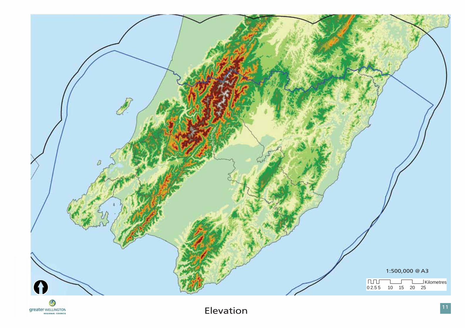
22Fmfwbujpo
0 5 10 15 20 252.5Kilometres
2;611-111!A!B4
[

MFHFOE1
23
2Xfmmjohupo!Sfhjpo!Mboetdbqf!BumbtUfssjupsjbm!Bvuipsjuz
Tmpqf!.!Qfsdfou
1!.!4!
4/1!.!9
9/1!.!26
26/1!.!36
36/1!.!46
46/1!boe!Vq
OpuftSlope values derived from 20m DEM. Jurisdictional data provided by Greater Wellington Regional Council.

24Tmpqf!205
0 2 4 6 8 101Kilometres
1:250,000 @ A31:250,000 @ A3
[
MFHFOE1
25
2Xfmmjohupo!Sfhjpo!Mboetdbqf!BumbtUfssjupsjbm!Bvuipsjuz
Tmpqf!.!Qfsdfou
1!.!4!
4/1!.!9
9/1!.!26
26/1!.!36
36/1!.!46
46/1!boe!Vq
OpuftSlope values derived from 20m DEM. Jurisdictional data provided by Greater Wellington Regional Council.

26Tmpqf!305
0 2 4 6 8 101Kilometres
[1:250,000 @ A31:250,000 @ A3

MFHFOE1
27
2Xfmmjohupo!Sfhjpo!Mboetdbqf!BumbtUfssjupsjbm!Bvuipsjuz
Tmpqf!.!Qfsdfou
1!.!4!
4/1!.!9
9/1!.!26
26/1!.!36
36/1!.!46
46/1!boe!Vq
OpuftSlope values derived from 20m DEM. Jurisdictional data provided by Greater Wellington Regional Council.

28Tmpqf!405
0 2 4 6 8 101Kilometres[
1:250,000 @ A31:250,000 @ A3
MFHFOE1
29
2Xfmmjohupo!Sfhjpo!Mboetdbqf!BumbtUfssjupsjbm!Bvuipsjuz
Tmpqf!.!Qfsdfou
1!.!4!
4/1!.!9
9/1!.!26
26/1!.!36
36/1!.!46
46/1!boe!Vq
OpuftSlope values derived from 20m DEM. Jurisdictional data provided by Greater Wellington Regional Council.

2:Tmpqf!505
0 2 4 6 8 101Kilometres
4 6 8 10KKiillooommeettres
[1:250,000 @ A31:250,000 @ A3

MFHFOE1
31
2Xfmmjohupo!Sfhjpo!Mboetdbqf!Bumbt
OpuftGeology polygons from the Institute of Geological and Nuclear Sciences (GNS) QMAP (1:250,000) series, showing main rock.
Ufssjupsjbm!Bvuipsjuz
Hsfbufs!Xfmmjohupo!Sfhjpobm!Dpvodjm
Tuvez!Bsfb
GeologyMAIN ROCK
algal limestone
andesite
basalt
breccia
chert
claystone
conglomerate
coquina
dunite
gabbro
gravel
greywacke
harzburgite
limestone
melange
mudstone
peat
quartzite
sand
sandstone
schist
silt
siltstone

32Hfpmphz!.!RNBQ!Cbtf!Spdl
[2;611-111!A!B4
[ 0 5 10 15 20 252.5Kilometres
MFHFOE1
33
2Xfmmjohupo!Sfhjpo!Mboetdbqf!Bumbt
Hfpqsftfswbujpo!Jowfoupsz
Mboegpsnt!boe!Hfpmphjdbm!Tjuft!)bsfb*
Mboegpsnt!boe!Hfpmphjdbm!Tjuft!)qpjou*
Ufssjupsjbm!Bvuipsjuz
OpuftFeatures from the Inventory and Maps of Important Geological Sites and Landforms in the Manawatu and Wellington Regions, 1996. Information was digitized by Isthmus Group. Copyright: Geological Society of New Zealand.

34Hfpqsftfswbujpo!Jowfoupsz!205
0 2 4 6 8 101Kilometres
1:250,000 @ A31:250,000 @ A3
[

MFHFOE1
35
2Xfmmjohupo!Sfhjpo!Mboetdbqf!Bumbt
OpuftFeatures from the Inventory and Maps of Important Geological Sites and Landforms in the Manawatu and Wellington Regions, 1996. Information was digitized by Isthmus Group. Copyright: Geological Society of New Zealand.
Hfpqsftfswbujpo!Jowfoupsz
Mboegpsnt!boe!Hfpmphjdbm!Tjuft!)bsfb*
Mboegpsnt!boe!Hfpmphjdbm!Tjuft!)qpjou*
Ufssjupsjbm!Bvuipsjuz

36Hfpqsftfswbujpo!Jowfoupsz!305
0 2 4 6 8 101Kilometres
1:250,000 @ A31:250,000 @ A3
[

MFHFOE1
37
2Xfmmjohupo!Sfhjpo!Mboetdbqf!Bumbt
OpuftFeatures from the Inventory and Maps of Important Geological Sites and Landforms in the Manawatu and Wellington Regions, 1996. Information was digitized by Isthmus Group. Copyright: Geological Society of New Zealand.
Hfpqsftfswbujpo!Jowfoupsz
Mboegpsnt!boe!Hfpmphjdbm!Tjuft!)bsfb*
Mboegpsnt!boe!Hfpmphjdbm!Tjuft!)qpjou*
Ufssjupsjbm!Bvuipsjuz

38Hfpqsftfswbujpo!Jowfoupsz!405
0 2 4 6 8 101Kilometres
1:250,000 @ A31:250,000 @ A3
[

MFHFOE1
39
2Xfmmjohupo!Sfhjpo!Mboetdbqf!Bumbt
OpuftFeatures from the Inventory and Maps of Important Geological Sites and Landforms in the Manawatu and Wellington Regions, 1996. Information was digitized by Isthmus Group. Copyright: Geological Society of New Zealand.
Hfpqsftfswbujpo!Jowfoupsz
Mboegpsnt!boe!Hfpmphjdbm!Tjuft!)bsfb*
Mboegpsnt!boe!Hfpmphjdbm!Tjuft!)qpjou*
Ufssjupsjbm!Bvuipsjuz

3:Hfpqsftfswbujpo!Jowfoupsz!505
0 2 4 6 8 101Kilometres
1:250,000 @ A31:250,000 @ A3[

MFHFOE1
41
2Xfmmjohupo!Sfhjpo!Mboetdbqf!BumbtTuvez!Bsfb
Hsfbufs!Xfmmjohupo!Sfhjpobm!Dpvodjm
Ufssjupsjbm!Bvuipsjuz
OpuftLand Environments of New Zealand (LENZ) is a classifi cation of fi fteen climate, landform, and soil variables chosen for their relevance to biological distributions. Data copyright Landcare Research, 2003.
Mboegpsn !.!MFO[
Fbtz!spmmjoh!ijmmt
Fbtz!spmmjoh!wpmdbojd !qmbufbv
Gmbu!gmppeqmbjot
Gmbu!qmbjot
Gmbu!dpbtubm!tboeqmbjot
Hfoumz!voevmbujoh!qmbjot
Tuffq!ijmmt
Tuffq!npvoubjopvt!ufssbjo
Tuspohmz!spmmjoh!ijmmt
Voevmbujoh!dpbtubm!gmppeqmbjot
Voevmbujoh!ijmmt
Voevmbujoh!mpx!tmpqft!bt!jo!Nu!Ubsboblj!sjohqmbjo
Wfsz!hfoumz!voevmbujoh!qmbjot

42Mboegpsn !)MFO[*
2;611-111!A!B4
0 5 10 15 20 252.5Kilometres
[

MFHFOE1
43
2Xfmmjohupo!Sfhjpo!Mboetdbqf!BumbtTuvez!Bsfb
Hsfbufs!Xfmmjohupo!Sfhjpobm!Dpvodjm
Ufssjupsjbm!Bvuipsjuz
Mboedpwfs!.!O[!Mboetdbqf!Dmbttjgjdbujpo
Bjsqpsu
Dpbtubm!Tboe
Fypujd !Gpsftu
Fypujd !Tdsvc
Gsftixbufs!Xfumboe
Ijhi!Qspevdjoh!Hsbttmboe
Ipsujdvmuvsf
Joejhfopvt!Gpsftu
Joejhfopvt!Tdsvc
Mblf
Mpx!Qspevdjoh!Hsbttmboe
Njof!ps!Evnq
Sjwfs
Tbmuxbufs!Xfumboe
Tfb
Tvc!Bmqjof!Tdsvc
Uvttpdl
Vscbo
OpuftLandcover is one of the categories of NZ Landscape Classifi cation data layer. Data from Lars Brabyn, University of Waikato, 2009.

44Mboedpwfs!gspn !O[!Mboetdbqf!Dmbttjgjdbujpo!
0 5 10 15 20 252.5Kilometres
2;611-111!A!B4
[

MFHFOE1
45
2Xfmmjohupo!Sfhjpo!Mboetdbqf!BumbtUfssjupsjbm!Bvuipsjuz
OpuftLCDB1 is intended to be used in areas such as environmental monitoring, planning and forest mapping. The majority of the imagery was acquired between October 1996 and March 1997. LCDB1 is a representation of New Zealand land cover circa 1997. Copyright Terralink.
Mboe!Dpwfs
Urban Areas
Vscbo
Vscbo!pqfo!tqbdf
Agricultural Land
Qsjnbsjmz!qbtupsbm
Qsjnbsjmz!ipsujdvmuvsf
Forest
Joejhfopvt!gpsftu
Qmboufe!gpsftu
Other Vegetative Classes
Tdsvc
Uvttpdl
Nbohspwf
Sjqbsjbo!xjmmpxt
Water
Jomboe!xbufs
Wetlands
Jomboe!xfumboet
Dpbtubm!xfumboet
Barren
Dpbtubm!tboet
Njoft!boe!evnqt
Cbsf!Hspvoe

46Mboedpwfs!)MDEC2w3*!Nbq!2!pg!5
0 2 4 6 8 101Kilometres
1:250,000 @ A31:250,000 @ A3
[

MFHFOE1
47
2Xfmmjohupo!Sfhjpo!Mboetdbqf!Bumbt
OpuftLCDB1 is intended to be used in areas such as environmental monitoring, planning and forest mapping. The majority of the imagery was acquired between October 1996 and March 1997. LCDB1 is a representation of New Zealand land cover circa 1997. Copyright Terralink.
Ufssjupsjbm!Bvuipsjuz
Mboe!Dpwfs
Urban Areas
Vscbo
Vscbo!pqfo!tqbdf
Agricultural Land
Qsjnbsjmz!qbtupsbm
Qsjnbsjmz!ipsujdvmuvsf
Forest
Joejhfopvt!gpsftu
Qmboufe!gpsftu
Other Vegetative Classes
Tdsvc
Uvttpdl
Nbohspwf
Sjqbsjbo!xjmmpxt
Water
Jomboe!xbufs
Wetlands
Jomboe!xfumboet
Dpbtubm!xfumboet
Barren
Dpbtubm!tboet
Njoft!boe!evnqt
Cbsf!Hspvoe

48Mboedpwfs!)MDEC2w3*!Nbq!3!pg!5
0 2 4 6 8 101Kilometres
1:250,000 @ A31:250,000 @ A3
[

MFHFOE1
49
2Xfmmjohupo!Sfhjpo!Mboetdbqf!Bumbt
OpuftLCDB1 is intended to be used in areas such as environmental monitoring, planning and forest mapping. The majority of the imagery was acquired between October 1996 and March 1997. LCDB1 is a representation of New Zealand land cover circa 1997. Copyright Terralink.
Ufssjupsjbm!Bvuipsjuz
Mboe!Dpwfs
Urban Areas
Vscbo
Vscbo!pqfo!tqbdf
Agricultural Land
Qsjnbsjmz!qbtupsbm
Qsjnbsjmz!ipsujdvmuvsf
Forest
Joejhfopvt!gpsftu
Qmboufe!gpsftu
Other Vegetative Classes
Tdsvc
Uvttpdl
Nbohspwf
Sjqbsjbo!xjmmpxt
Water
Jomboe!xbufs
Wetlands
Jomboe!xfumboet
Dpbtubm!xfumboet
Barren
Dpbtubm!tboet
Njoft!boe!evnqt
Cbsf!Hspvoe

4:Mboedpwfs!)MDEC2w3*!Nbq!4!pg!5
0 2 4 6 8 101Kilometres
1:250,000 @ A31:250,000 @ A3
[

MFHFOE1
51
2Xfmmjohupo!Sfhjpo!Mboetdbqf!Bumbt
OpuftLCDB1 is intended to be used in areas such as environmental monitoring, planning and forest mapping. The majority of the imagery was acquired between October 1996 and March 1997. LCDB1 is a representation of New Zealand land cover circa 1997. Copyright Terralink.
Ufssjupsjbm!Bvuipsjuz
Mboe!Dpwfs
Urban Areas
Vscbo
Vscbo!pqfo!tqbdf
Agricultural Land
Qsjnbsjmz!qbtupsbm
Qsjnbsjmz!ipsujdvmuvsf
Forest
Joejhfopvt!gpsftu
Qmboufe!gpsftu
Other Vegetative Classes
Tdsvc
Uvttpdl
Nbohspwf
Sjqbsjbo!xjmmpxt
Water
Jomboe!xbufs
Wetlands
Jomboe!xfumboet
Dpbtubm!xfumboet
Barren
Dpbtubm!tboet
Njoft!boe!evnqt
Cbsf!Hspvoe

52Mboedpwfs!)MDEC2w3*!Nbq!5!pg!5
0 2 4 6 8 101Kilometres
1:250,000 @ A31:250,000 @ A3
[

MFHFOE1
53
2Xfmmjohupo!Sfhjpo!Mboetdbqf!BumbtTuvez!Bsfb
Hsfbufs!Xfmmjohupo!Sfhjpobm!Dpvodjm
OpuftCatchment order is a measure of the relative size of catchments. Catchment sizes range from the smallest, fi rst-order, to the largest, the twelfth-order (the Amazon River). Water catchment data from National Institute of Water & Atmospheric Research (NIWA). General classes displayed here. More detailed data available. Copyright NIWA.
Dbudinfout!.!OJXB
Dbudinfou!Psefs!8
Dbudinfou!Psefs!7
Dbudinfou!Psefs!6

54Dbudinfout
0 5 10 15 20 252.5Kilometres
[2;611-111!A!B4

MFHFOE1
55
2Xfmmjohupo!Sfhjpo!Mboetdbqf!BumbtTuvez!Bsfb
Hsfbufs!Xfmmjohupo!Sfhjpobm!Dpvodjm
Ufssjupsjbm!Bvuipsjuz
OpuftRegional Parks data from Greater Wellington Regional Council. Department of Conservation (DOC) data copyright DOC.
Qvcmjd !Mboe!0!Sftfswft
EPD!Ftubuft-!Sftfswft-!Dpwfobout
Sfhjpobm!Qbslt
UB!Sftfswft

56Qvcmjd !Mboe
2;611-111
0 5 10 15 20 252.5Kilometres[

MFHFOE1
57
2Xfmmjohupo!Sfhjpo!Mboetdbqf!Bumbt
Vscbo!Bsfbt0Jogsbtusvduvsf
Cvjmu!vq!bsfbt
Tubuf!Ijhixbzt
Usbotqpxfs!Obujpobm!Hsje!Ofuxpsl
Usbotqpxfs!Obujpobm!Hsje!Qpjout
Sbjmspbe
Tuvez!Bsfb
Hsfbufs!Xfmmjohupo!Sfhjpobm!Dpvodjm
OpuftBuilt up areas, railroad and highway data from New Zealand topography, Land Information New Zealand (LINZ).

58Vscbo!Bsfbt0Sfhjpobm!Jogsbtusvduvsf
0 5 10 15 20 252.5Kilometres
2;611-111!A!B4
[

MFHFOE1
59
2Xfmmjohupo!Sfhjpo!Mboetdbqf!Bumbt
Sfhjpobm!Ifsjubhf!Ebub
Territorial AuthorityIfsjubhf!Qpjout
Xbij!Ubqv!Tjuft!)LDED-!Xbjsbsbqb!Dpncjofe!Ejtusjdu!Qmbo!pomz!*
Ufssjupsjbm!Bvuipsjuz
Mpdbm!Ifsjubhf!Ebub
NZ Archaeology AssociationBsdibfpmphz!Qpjout
Historic TrustTdifevmfe!Ijtupsjd!Qmbdft-!Dbufhpsz!J!boe!JJ
OpuftArchaeology points copyright New Zealand Archaeological Association, copyright 2009.• The data layer represented here is a draft digital representation of the registered sites. Digitised by Isthmus. Copyright • Historic Places Trust. Mapped information is made available by the NZHPT for inspection on these conditions: (a) Except for any liability to consumers under the Consumer Guarantees Act 1993, the NZHPT is not liable for any loss or damage suffered by you or by any others as a result of your or any other person’s reliance on this information. (b) If you are inspecting this information for business purposes, the Consumer Guarantees Act 1993 does not apply. See full disclaimer in geodatabase metadata.Heritage Points from Territorial Authority Operative District Plan maps.Wahi Tapu Sites from Kapiti Coast District • Council and Wairarapa Combined District Plan jurisdictions.

5:Ifsjubhf!205!
0 2 4 6 8 101Kilometres
1:250,000 @ A31:250,000 @ A3
[

MFHFOE1
61
2Xfmmjohupo!Sfhjpo!Mboetdbqf!Bumbt
Sfhjpobm!Ifsjubhf!Ebub
Territorial AuthorityIfsjubhf!Qpjout
Xbij!Ubqv!Tjuft!)LDED-!Xbjsbsbqb!Dpncjofe!Ejtusjdu!Qmbo!pomz!*
Ufssjupsjbm!Bvuipsjuz
Mpdbm!Ifsjubhf!Ebub
NZ Archaeology AssociationBsdibfpmphz!Qpjout
Historic TrustTdifevmfe!Ijtupsjd!Qmbdft-!Dbufhpsz!J!boe!JJ
OpuftArchaeology points copyright New Zealand Archaeological Association, copyright 2009.• The data layer represented here is a draft digital representation of the registered sites. Digitised by Isthmus. Copyright • Historic Places Trust. Mapped information is made available by the NZHPT for inspection on these conditions: (a) Except for any liability to consumers under the Consumer Guarantees Act 1993, the NZHPT is not liable for any loss or damage suffered by you or by any others as a result of your or any other person’s reliance on this information. (b) If you are inspecting this information for business purposes, the Consumer Guarantees Act 1993 does not apply. See full disclaimer in geodatabase metadata.Heritage Points from Territorial Authority Operative District Plan maps.Wahi Tapu Sites from Kapiti Coast District • Council and Wairarapa Combined District Plan jurisdictions.

62Ifsjubhf!305
0 2 4 6 8 101Kilometres
1:250,000 @ A31:250,000 @ A3
[

MFHFOE1
63
2Xfmmjohupo!Sfhjpo!Mboetdbqf!Bumbt
Sfhjpobm!Ifsjubhf!Ebub
Territorial AuthorityIfsjubhf!Qpjout
Xbij!Ubqv!Tjuft!)LDED-!Xbjsbsbqb!Dpncjofe!Ejtusjdu!Qmbo!pomz!*
Ufssjupsjbm!Bvuipsjuz
Mpdbm!Ifsjubhf!Ebub
NZ Archaeology AssociationBsdibfpmphz!Qpjout
Historic TrustTdifevmfe!Ijtupsjd!Qmbdft-!Dbufhpsz!J!boe!JJ
OpuftArchaeology points copyright New Zealand Archaeological Association, copyright 2009.• The data layer represented here is a draft digital representation of the registered sites. Digitised by Isthmus. Copyright • Historic Places Trust. Mapped information is made available by the NZHPT for inspection on these conditions: (a) Except for any liability to consumers under the Consumer Guarantees Act 1993, the NZHPT is not liable for any loss or damage suffered by you or by any others as a result of your or any other person’s reliance on this information. (b) If you are inspecting this information for business purposes, the Consumer Guarantees Act 1993 does not apply. See full disclaimer in geodatabase metadata.Heritage Points from Territorial Authority Operative District Plan maps.Wahi Tapu Sites from Kapiti Coast District • Council and Wairarapa Combined District Plan jurisdictions.

64Ifsjubhf!405
0 2 4 6 8 101Kilometres
1:250,000 @ A31:250,000 @ A3
[

MFHFOE1
65
2Xfmmjohupo!Sfhjpo!Mboetdbqf!Bumbt
Sfhjpobm!Ifsjubhf!Ebub
Territorial AuthorityIfsjubhf!Qpjout
Xbij!Ubqv!Tjuft!)LDED-!Xbjsbsbqb!Dpncjofe!Ejtusjdu!Qmbo!pomz!*
Ufssjupsjbm!Bvuipsjuz
Mpdbm!Ifsjubhf!Ebub
NZ Archaeology AssociationBsdibfpmphz!Qpjout
Historic TrustTdifevmfe!Ijtupsjd!Qmbdft-!Dbufhpsz!J!boe!JJ
OpuftArchaeology points copyright New Zealand Archaeological Association, copyright 2009.• The data layer represented here is a draft digital representation of the registered sites. Digitised by Isthmus. Copyright • Historic Places Trust. Mapped information is made available by the NZHPT for inspection on these conditions: (a) Except for any liability to consumers under the Consumer Guarantees Act 1993, the NZHPT is not liable for any loss or damage suffered by you or by any others as a result of your or any other person’s reliance on this information. (b) If you are inspecting this information for business purposes, the Consumer Guarantees Act 1993 does not apply. See full disclaimer in geodatabase metadata.Heritage Points from Territorial Authority Operative District Plan maps.Wahi Tapu Sites from Kapiti Coast District • Council and Wairarapa Combined District Plan jurisdictions.

66Ifsjubhf!Nbq!505
0 2 4 6 8 101Kilometres
1:250,000 @ A31:250,000 @ A3
[

MFHFOE1
67
2Xfmmjohupo!Sfhjpo!Mboetdbqf!Bumbt
OpuftMap derived from LENZ Level I data. See Land Envrironments of New Zealand (2003) for further descriptions of classes. Data copyright Ministry for the Environment.
MFO[!Fowjsponfout!
Ufssjupsjbm!Bvuipsjuz
Hsfbufs!Xfmmjohupo!Sfhjpobm!Dpvodjm
Tuvez!Bsfb
LEVEL I
D!.!Xftufso!'!tpvuifso!Opsui!Jtmboe!mpxmboet
G!.!Dfousbm!ijmm!dpvousz!'!wpmdbojd!qmbufbv
I!.!Dfousbm!tboez!sfdfou!tpjmt
J!.!Dfousbm!qppsmz.esbjofe!sfdfou!tpjmt
K!.!Dfousbm!xfmm.esbjofe!sfdfou!tpjmt
Ovmm!)sfe*!
Q!.!Dfousbm!Npvoubjot

68MFO[!Mfwfm!J!Fowjsponfout
0 5 10 15 20 252.5Kilometres
2;611-111!A!B4
[

MFHFOE1
69
2Xfmmjohupo!Sfhjpo!Mboetdbqf!Bumbt
Fowjsponfoubm!Nbobhfnfou!!
EPD!Sftfswft-!Ftubuft!boe!Dpowfobout
Tjhojgjdbou!Obuvsbm!Bsfbt-!!Qspqptfe!Dpncjofe!Xbjsbsbqb!Ejtusjdu!Qmbo
EPD!SBNTBS!Dboejebuf!Tjuft
EPD!Qspufdufe!Qsjwbuf!Mboe
EPD!Joejhfopvt!Uisfbufofe!Fowjsponfout
EPD!SBQ!Tjuft
Ufssjupsjbm!Bvuipsjuz
OpuftDOC Reserves, Estates, and Covenants from Department of Conservation (DOC). Includes estates, including forest • parks and reserves, crown reserves and covenants in the Wellington Conservancy, 2008.Signifi cant Natural Areas, Proposed Combined Wairarapa District Plan.• DOC RAMSAR Candidate Sites 2008 under the Protected Natural Areas initiative, copyright Department of • Conservation.DOC Protected Private Land, copyright Department of Conservation.• DOC Indigenous Threatened Environments as defi ned for the Protected Natural Areas initiative 2008, copyright • Department of Conservation. DOC RAP Sites, “Recommended Areas for Protection”, 2008, copyright Department of Conservation.•

6:Fowjsponfoubm!Nbobhfnfou!205
0 2 4 6 8 101Kilometres
1:250,000 @ A31:250,000 @ A3
[

MFHFOE1
71
2Xfmmjohupo!Sfhjpo!Mboetdbqf!Bumbt
Fowjsponfoubm!Nbobhfnfou!!
EPD!Sftfswft-!Ftubuft!boe!Dpowfobout
Tjhojgjdbou!Obuvsbm!Bsfbt-!!Qspqptfe!Dpncjofe!Xbjsbsbqb!Ejtusjdu!Qmbo
EPD!SBNTBS!Dboejebuf!Tjuft
EPD!Qspufdufe!Qsjwbuf!Mboe
EPD!Joejhfopvt!Uisfbufofe!Fowjsponfout
EPD!SBQ!Tjuft
Ufssjupsjbm!Bvuipsjuz
OpuftDOC Reserves, Estates, and Covenants from Department of Conservation (DOC). Includes estates, including forest • parks and reserves, crown reserves and covenants in the Wellington Conservancy, 2008.Signifi cant Natural Areas, Proposed Combined Wairarapa District Plan.• DOC RAMSAR Candidate Sites 2008 under the Protected Natural Areas initiative, copyright Department of • Conservation.DOC Protected Private Land, copyright Department of Conservation.• DOC Indigenous Threatened Environments as defi ned for the Protected Natural Areas initiative 2008, copyright • Department of Conservation. DOC RAP Sites, “Recommended Areas for Protection”, 2008, copyright Department of Conservation.•

72
0 2 4 6 8 101Kilometres
1:250,000 @ A31:250,000 @ A3
[Fowjsponfoubm!Nbobhfnfou!305

MFHFOE1
73
2Xfmmjohupo!Sfhjpo!Mboetdbqf!Bumbt
Fowjsponfoubm!Nbobhfnfou!!
EPD!Sftfswft-!Ftubuft!boe!Dpowfobout
Tjhojgjdbou!Obuvsbm!Bsfbt-!!Qspqptfe!Dpncjofe!Xbjsbsbqb!Ejtusjdu!Qmbo
EPD!SBNTBS!Dboejebuf!Tjuft
EPD!Qspufdufe!Qsjwbuf!Mboe
EPD!Joejhfopvt!Uisfbufofe!Fowjsponfout
EPD!SBQ!Tjuft
Ufssjupsjbm!Bvuipsjuz
OpuftDOC Reserves, Estates, and Covenants from Department of Conservation (DOC). Includes estates, including forest • parks and reserves, crown reserves and covenants in the Wellington Conservancy, 2008.Signifi cant Natural Areas, Proposed Combined Wairarapa District Plan.• DOC RAMSAR Candidate Sites 2008 under the Protected Natural Areas initiative, copyright Department of • Conservation.DOC Protected Private Land, copyright Department of Conservation.• DOC Indigenous Threatened Environments as defi ned for the Protected Natural Areas initiative 2008, copyright • Department of Conservation. DOC RAP Sites, “Recommended Areas for Protection”, 2008, copyright Department of Conservation.•

74
0 2 4 6 8 101Kilometres
1:250,000 @ A31:250,000 @ A3
[Fowjsponfoubm!Nbobhfnfou!405

MFHFOE1
75
2Xfmmjohupo!Sfhjpo!Mboetdbqf!Bumbt
Fowjsponfoubm!Nbobhfnfou!!
EPD!Sftfswft-!Ftubuft!boe!Dpowfobout
Tjhojgjdbou!Obuvsbm!Bsfbt-!!Qspqptfe!Dpncjofe!Xbjsbsbqb!Ejtusjdu!Qmbo
EPD!SBNTBS!Dboejebuf!Tjuft
EPD!Qspufdufe!Qsjwbuf!Mboe
EPD!Joejhfopvt!Uisfbufofe!Fowjsponfout
EPD!SBQ!Tjuft
Ufssjupsjbm!Bvuipsjuz
OpuftDOC Reserves, Estates, and Covenants from Department of Conservation (DOC). Includes estates, including forest • parks and reserves, crown reserves and covenants in the Wellington Conservancy, 2008.Signifi cant Natural Areas, Proposed Combined Wairarapa District Plan.• DOC RAMSAR Candidate Sites 2008 under the Protected Natural Areas initiative, copyright Department of • Conservation.DOC Protected Private Land, copyright Department of Conservation.• DOC Indigenous Threatened Environments as defi ned for the Protected Natural Areas initiative 2008, copyright • Department of Conservation. DOC RAP Sites, “Recommended Areas for Protection”, 2008, copyright Department of Conservation.•

76
0 2 4 6 8 101Kilometres
1:250,000 @ A31:250,000 @ A3
[Fowjsponfoubm!Nbobhfnfou!505

MFHFOE1
77
2Xfmmjohupo!Sfhjpo!Mboetdbqf!Bumbt
Mboe!Vtf!Dbqbcjmjuz!
Ufssjupsjbm!Bvuipsjuz
j
jj
jjj
jw
w
wj
wjj
wjjj
m.!Mblf
s.!Sjwfs
u.!Upxo
Opuft
There are eight Land Use Capability classes indicating the broad degree of limitation to use for permanent sustained production. In general terms, land classes I to IV are suitable for pastoral, arable, and forestry use while Classes V to VII land is suitable for pastoral or forestry use. Class VIII land is suitable for protection purposes only. Each land class can be defi ned further according to limitations to use and suitable management techniques. NZLRI data is from Landcare Research.
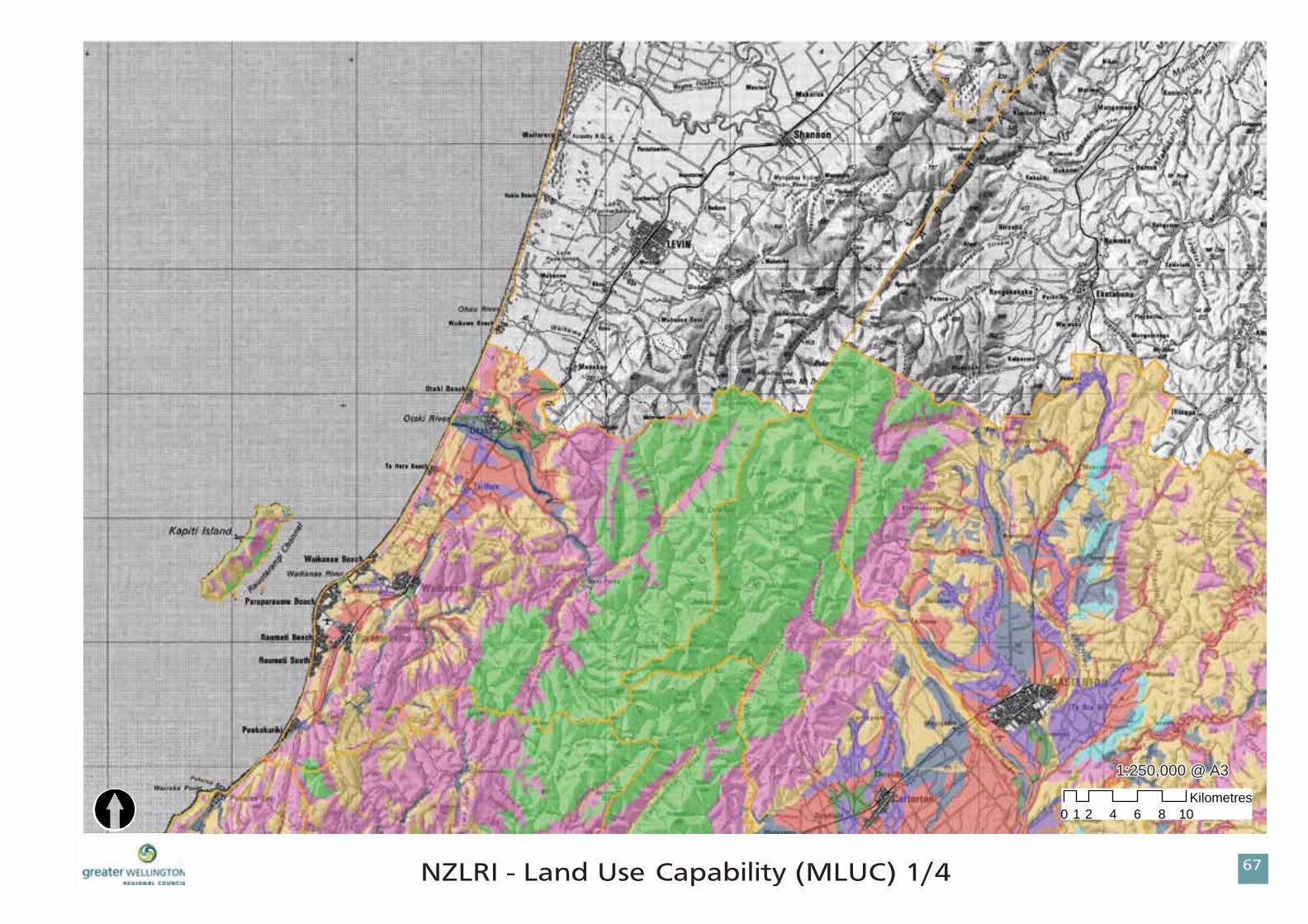
78O[MSJ!.!Mboe!Vtf!Dbqbcjmjuz!)NMVD*!205
0 2 4 6 8 101Kilometres
[1:250,000 @ A31:250,000 @ A3

MFHFOE1
79
2Xfmmjohupo!Sfhjpo!Mboetdbqf!Bumbt
Mboe!Vtf!Dbqbcjmjuz!
Ufssjupsjbm!Bvuipsjuz
j
jj
jjj
jw
w
wj
wjj
wjjj
m.!Mblf
s.!Sjwfs
u.!Upxo
Opuft
There are eight Land Use Capability classes. Simply, land classes I to IV are suitable for pastoral, arable, and forestry use while Classes V to VII land is suitable for pastoral or forestry use. Class VIII land is suitable for protection purposes only. Each land class can be defi ned further according to limitations to use and suitable management techniques. NZLRI data is from Landcare Research.

7:O[MSJ!.!Mboe!Vtf!Dbqbcjmjuz!)NMVD*!305
0 2 4 6 8 101Kilometres[
1:250,000 @ A31:250,000 @ A3

MFHFOE1
81
2Xfmmjohupo!Sfhjpo!Mboetdbqf!Bumbt
Mboe!Vtf!Dbqbcjmjuz!
Ufssjupsjbm!Bvuipsjuz
j
jj
jjj
jw
w
wj
wjj
wjjj
m.!Mblf
s.!Sjwfs
u.!Upxo
Opuft
There are eight Land Use Capability classes. Simply, land classes I to IV are suitable for pastoral, arable, and forestry use while Classes V to VII land is suitable for pastoral or forestry use. Class VIII land is suitable for protection purposes only. Each land class can be defi ned further according to limitations to use and suitable management techniques. NZLRI data is from Landcare Research.

82O[MSJ!.!Mboe!Vtf!Dbqbcjmjuz!)NMVD*!405
0 2 4 6 8 101Kilometres[
1:250,000 @ A31:250,000 @ A3

MFHFOE1
83
2Xfmmjohupo!Sfhjpo!Mboetdbqf!Bumbt
Mboe!Vtf!Dbqbcjmjuz!
Ufssjupsjbm!Bvuipsjuz
j
jj
jjj
jw
w
wj
wjj
wjjj
m.!Mblf
s.!Sjwfs
u.!Upxo
Opuft
There are eight Land Use Capability classes. Simply, land classes I to IV are suitable for pastoral, arable, and forestry use while Classes V to VII land is suitable for pastoral or forestry use. Class VIII land is suitable for protection purposes only. Each land class can be defi ned further according to limitations to use and suitable management techniques. NZLRI data is from Landcare Research.

84O[MSJ!.!Mboe!Vtf!Dbqbcjmjuz!)NMVD*!505
0 2 4 6 8 101Kilometres[
1:250,000 @ A31:250,000 @ A3

MFHFOE1
85
2Xfmmjohupo!Sfhjpo!Mboetdbqf!Bumbt
Fdpepnbjot.!HXSD42!Sfxb!Ijmm!Dpvousz
43!Ipnfxppe
44!Nu!Njtfsz!.!Nbvohbqblfib
45!Opsuifso!Xbjsbsbqb!Ijmm!Dpvousz
46!Nbvsjdfwjmmf!Ijmm!Dpvousz
47!Sbohjuvnbv!Ftdbsqnfou
48!Mpxfs!Nbubjlpob
49!Vqqfs!Nbubjlpob
4:!Xibsfbnb!Sjwfs
51!Ubjqpt
52!Qfodbsspx!Ifbe!.!Fbtucpvsof
53!Fbtucpvsof!.!Qpjou!Ipxbse0Tfbu
54!Tfbwjfx!.!Qfupof
55!Qfupof!.!Lbjxibsbxibsb
56!Xfmmjohupo!Djuz
57!Njsbnbs!Gmbut
58!Xftufso!Ufnqfsbuf!Gppuijmmt
59!Qpjou!Epstfu!.!Nblbsb
5:!Nblbsb0Qvlfsvb!Cbz
61!Qjqjovj!Qpjou
62!Xbjsblb!xjui!Hsffo!Qpjou
63!Qpsjsvb
64!Lbqjuj!Dpbtu
65!Uf!Ipsp!.!Publj!Bmmvwjbm!Qmbjo
66!Sfjlpsbohj
67!Xftufso!Ijmmt
68!Xftufso!Ijmmt!Dmpve
86Fdpepnbjot
2;611-111
0 5 10 15 20 252.5Kilometres
[

MFHFOE1
87
2Xfmmjohupo!Sfhjpo!Mboetdbqf!Bumbt
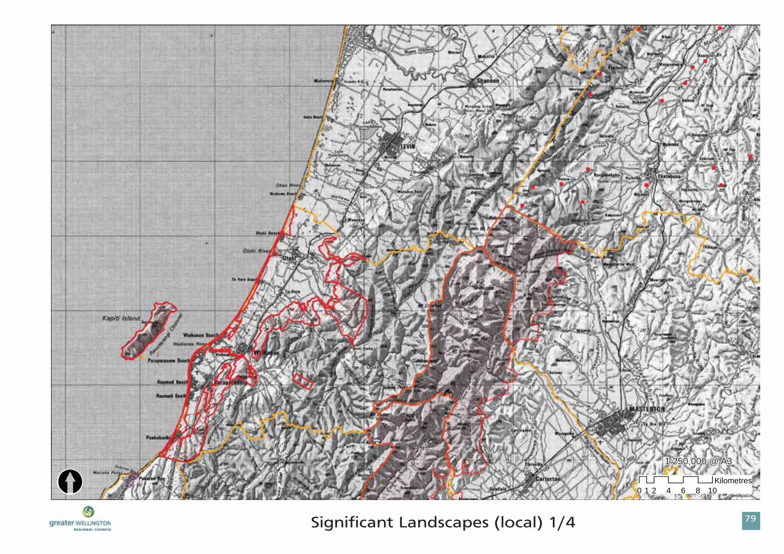
Tjhojgjdbou!Mboetdbqft!!
Pvutuboejoh!Obuvsbm!Mboetdbqft!)Ipsj{pot!Sfhjpobm!Dpvodjm*
Dpbtubm!Tjuft!pg!Sfhjpobm!Tjhojgjdbodf!)HXSD*
Dpbtubm!Mboetdbqf!boe!Tfbtdbqft!pg!Tjhojgjdbodf!)EPD*
OpuftHorizons Regional Council Outstanding Natural Landscapes -reference Schedule F Proposed One Plan, • GWRC Coastal Sites of Regional Signifi cance-reference Appendix 1 draft Regional Policy Statement (! Note Appendix • 1 is not included in the proposed RPS [March, 2008]. Therefore, this dataset has no status under the RMA. It is provided here for reference only.)DOC Coastal Landscape and Seascapes of Signifi cance-reference Coastal Resources Inventory (1990), copyright • Department iof Conservation.
Tuvez!Bsfb
Hsfbufs!Xfmmjohupo!Sfhjpobm!Dpvodjm
Ufssjupsjbm!Bvuipsjuz
/

88
1:500,000 @ A3
0 5 10 15 20 252.5Kilometres
Tjhojgjdbou!Mboetdbqft!)Sfhjpobm*!
! Please see Notes on previous page for data sources.!!!!!!!!!!!!!!!!!!!!!!!!!!!!! !! !!! ! !! !!!!! !!!!!!!!!! !!!!!! PlPlPlPlPlPPlPPlPPPPlPlPlPlPlPPlPlPPPPlPlPlPlPPPlPlPPPlPlPPlPlPlPlPPPPPPlPPPPPPPlPPlPPPPPPPlPPPPPPPPPPlPPPPlPPPPPPPPPPPPlPPPPPPPlPPPPPPPPP eaeaeaeaeaeaeaeaeaeaeaeaeaeaeaeaeaaeaeeaeaeaeaeaeaeaeaaeeaeaeaeaaeeaeaeeeeeeeeeee seseseseseseseseseseseseesesesesesesesesesesesesesesesesees s s s s ss ss ss sss ss sssss sss s ss sssssssseeeeeeeeeeeeeeeeeeeeeeeeeeeeeeeeeeeeeeeeeeeeeeeeeeeeeeeeeeeeeeeeeeeeeeeeeeeeeeeeeeeeeeee N N N N N N N NNNNNN N N N NN N NNNNNNNNNNN
[

MFHFOE1
89
2Xfmmjohupo!Sfhjpo!Mboetdbqf!Bumbt
Tjhojgjdbou!Mboetdbqft!)mpdbm*
Kapiti Coast DistrictPvutuboejoh!Obuvsbm!Mboetdbqf
Ufssjupsjbm!Bvuipsjuz
Carterton DistrictPvutuboejoh!Obuvsbm!Mboetdbqf
Masterton DistrictPvutuboejoh!Obuvsbm!Mboetdbqf
South Wairarapa DistrictPvutuboejoh!Obuvsbm!Mboetdbqf
Upper Hutt CitySjehfmjoft
Hutt CityMboetdbqf!Qspufdujpo!Bsfbt!)Sftjefoujbm!Bdujwjuz!Bsfb*
Wellington CitySjehft!boe!Ijmmupqt!EQ!Dibohf!44
Porirua CityMboetdbqf!Qspufdujpo!Bsfbt
Horowhenua DistrictOpof
Tararua DistrictTjhojgjdbou!Obuvsbm!Gfbuvsft!boe!Mboetdbqft
OpuftCombined Wairarapa District Council Outstanding Natural Landscape-reference Proposed Combined Wairarapa • District Plan.Upper Hutt City Council Ridgelines-reference Operative District Plan maps.• Hutt City Landscape Protection Areas-reference Operative District Plan maps (Residential Activity Area).• Wellington City Council Ridgelines and Hilltops-reference Proposed District Plan Change 33.• Porirua City Council Landscape Protection Areas-reference Operative District Plan.•
8:Tjhojgjdbou!Mboetdbqft!)mpdbm*!205!
0 2 4 6 8 101Kilometres[
1:250,000 @ A31:250,000 @ A3

MFHFOE1
91
2Xfmmjohupo!Sfhjpo!Mboetdbqf!Bumbt
Tjhojgjdbou!Mboetdbqft!)mpdbm*
Kapiti Coast DistrictPvutuboejoh!Obuvsbm!Mboetdbqf
Ufssjupsjbm!Bvuipsjuz
Carterton DistrictPvutuboejoh!Obuvsbm!Mboetdbqf
Masterton DistrictPvutuboejoh!Obuvsbm!Mboetdbqf
South Wairarapa DistrictPvutuboejoh!Obuvsbm!Mboetdbqf
Upper Hutt CitySjehfmjoft
Hutt CityMboetdbqf!Qspufdujpo!Bsfbt!)Sftjefoujbm!Bdujwjuz!Bsfb*
Wellington CitySjehft!boe!Ijmmupqt!EQ!Dibohf!44
Porirua CityMboetdbqf!Qspufdujpo!Bsfbt
Horowhenua DistrictOpof
Tararua DistrictTjhojgjdbou!Obuvsbm!Gfbuvsft!boe!Mboetdbqft
OpuftCombined Wairarapa District Council Outstanding Natural Landscape-reference Proposed Combined Wairarapa • District Plan.Upper Hutt City Council Ridgelines-reference Operative District Plan maps.• Hutt City Landscape Protection Areas-reference Operative District Plan maps (Residential Activity Area).• Wellington City Council Ridgelines and Hilltops-reference Proposed District Plan Change 33.• Porirua City Council Landscape Protection Areas-reference Operative District Plan.•

92
0 2 4 6 8 101Kilometres
Tjhojgjdbou!Mboetdbqft!)mpdbm*!305!
[1:250,000 @ A31:250,000 @ A3

MFHFOE1
93
2Xfmmjohupo!Sfhjpo!Mboetdbqf!Bumbt
Tjhojgjdbou!Mboetdbqft!)mpdbm*
Kapiti Coast DistrictPvutuboejoh!Obuvsbm!Mboetdbqf
Ufssjupsjbm!Bvuipsjuz
Carterton DistrictPvutuboejoh!Obuvsbm!Mboetdbqf
Masterton DistrictPvutuboejoh!Obuvsbm!Mboetdbqf
South Wairarapa DistrictPvutuboejoh!Obuvsbm!Mboetdbqf
Upper Hutt CitySjehfmjoft
Hutt CityMboetdbqf!Qspufdujpo!Bsfbt!)Sftjefoujbm!Bdujwjuz!Bsfb*
Wellington CitySjehft!boe!Ijmmupqt!EQ!Dibohf!44
Porirua CityMboetdbqf!Qspufdujpo!Bsfbt
Horowhenua DistrictOpof
Tararua DistrictTjhojgjdbou!Obuvsbm!Gfbuvsft!boe!Mboetdbqft
OpuftCombined Wairarapa District Council Outstanding Natural Landscape-reference Proposed Combined Wairarapa • District Plan.Upper Hutt City Council Ridgelines-reference Operative District Plan maps.• Hutt City Landscape Protection Areas-reference Operative District Plan maps (Residential Activity Area).• Wellington City Council Ridgelines and Hilltops-reference Proposed District Plan Change 33.• Porirua City Council Landscape Protection Areas-reference Operative District Plan.•

94
0 2 4 6 8 101Kilometres
Tjhojgjdbou!Mboetdbqft!)mpdbm*!405!
[1:250,000 @ A31:250,000 @ A3

MFHFOE1
95
2Xfmmjohupo!Sfhjpo!Mboetdbqf!Bumbt
Tjhojgjdbou!Mboetdbqft!)mpdbm*
Kapiti Coast DistrictPvutuboejoh!Obuvsbm!Mboetdbqf
Ufssjupsjbm!Bvuipsjuz
Carterton DistrictPvutuboejoh!Obuvsbm!Mboetdbqf
Masterton DistrictPvutuboejoh!Obuvsbm!Mboetdbqf
South Wairarapa DistrictPvutuboejoh!Obuvsbm!Mboetdbqf
Upper Hutt CitySjehfmjoft
Hutt CityMboetdbqf!Qspufdujpo!Bsfbt!)Sftjefoujbm!Bdujwjuz!Bsfb*
Wellington CitySjehft!boe!Ijmmupqt!EQ!Dibohf!44
Porirua CityMboetdbqf!Qspufdujpo!Bsfbt
Horowhenua DistrictOpof
Tararua DistrictTjhojgjdbou!Obuvsbm!Gfbuvsft!boe!Mboetdbqft
OpuftCombined Wairarapa District Council Outstanding Natural Landscape-reference Proposed Combined Wairarapa • District Plan.Upper Hutt City Council Ridgelines-reference Operative District Plan maps.• Hutt City Landscape Protection Areas-reference Operative District Plan maps (Residential Activity Area).• Wellington City Council Ridgelines and Hilltops-reference Proposed District Plan Change 33.• Porirua City Council Landscape Protection Areas-reference Operative District Plan.•

96
0 2 4 6 8 101Kilometres
Tjhojgjdbou!Mboetdbqft!)mpdbm*!505!
[1:250,000 @ A31:250,000 @ A3

MFHFOE1
97
2Xfmmjohupo!Sfhjpo!Mboetdbqf!Bumbt
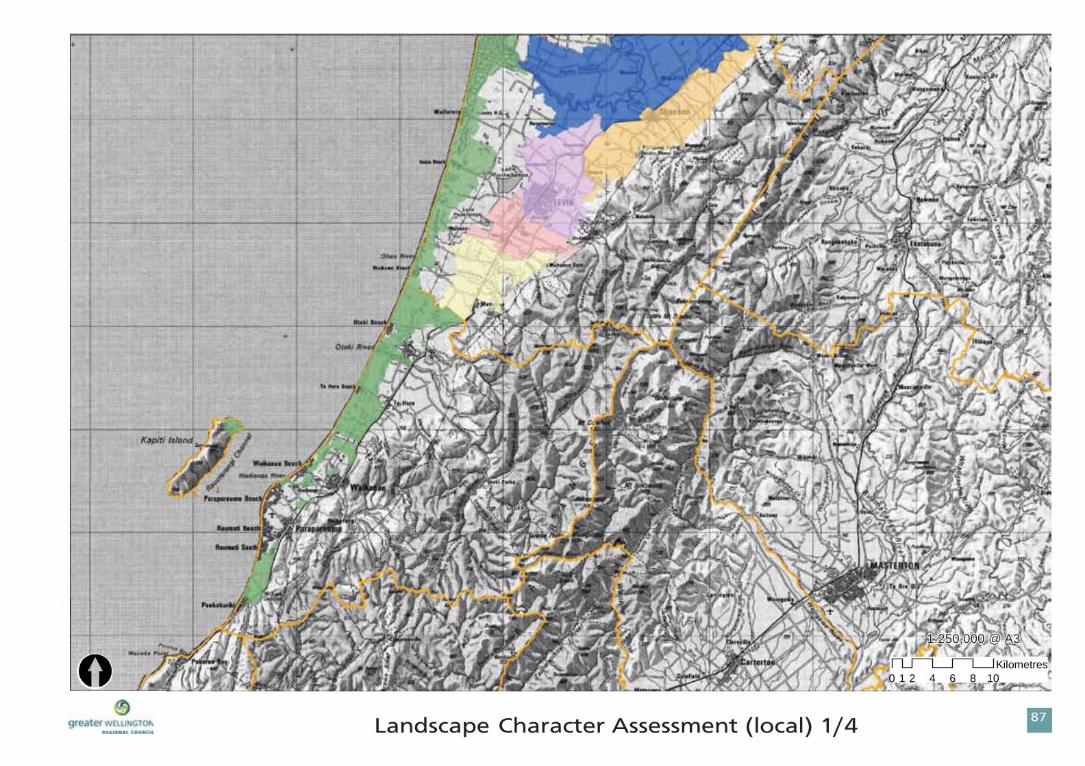
Mboetdbqf!Dibsbdufs!
Kapiti Coast DistrictDpbtubm!Sfhjpo
Ufssjupsjbm!Bvuipsjuz
Carterton DistrictDpbtubm!Mboetdbqf!Dibsbdufs!Bsfbt
Dpbtubm!Mboetdbqf!Vojut!
Masterton DistrictDpbtubm!Mboetdbqf!Dibsbdufs!Bsfbt
Dpbtubm!Mboetdbqf!Vojut!
South Wairarapa DistrictDpbtubm!Mboetdbqf!Dibsbdufs!Bsfbt
Dpbtubm!Mboetdbqf!Vojut!
Upper Hutt CityOpof
Hutt CityOpof
Wellington City
Vscbo!Dibsbdufs!Bsfb
Porirua CityOpof
Horowhenua District
Dpbtubm!Bsfb
Npvupvb.Pqjlj!Qmbjot
Lvlv
Mfwjo.Lpqvubspb
Mfwjo.Pibv
Ubsbsvb!Ufssbdft
Tararua DistrictOpof
MBOETDBQF!EPNBJOT
Dpncjofe!Xbjsbsbqb!Ejtusjdu!Dpvodjmt
OpuftKapiti Coast District Council Coastal Region reference Chapter C.9, Kapiti Coast District Council District Plan Volume I• Combined Wairarapa District Council Coastal Landscape Character Areas and Coastal Landscape Units • referenceWairarapa Coastal Strategy (CWDC, 2002)Wellington City data from District Plan.• Horowhenua District Council Landscape Domains reference Landscape Assessment of the Rural Environment (HDC, • 2008)
98Mboetdbqf!Dibsbdufs!Bttfttnfou!)mpdbm*!205
0 2 4 6 8 101Kilometres[
1:250,000 @ A31:250,000 @ A3

MFHFOE1
99
2Xfmmjohupo!Sfhjpo!Mboetdbqf!Bumbt
Mboetdbqf!Dibsbdufs!
Kapiti Coast DistrictDpbtubm!Sfhjpo
Ufssjupsjbm!Bvuipsjuz
Carterton DistrictDpbtubm!Mboetdbqf!Dibsbdufs!Bsfbt
Dpbtubm!Mboetdbqf!Vojut!
Masterton DistrictDpbtubm!Mboetdbqf!Dibsbdufs!Bsfbt
Dpbtubm!Mboetdbqf!Vojut!
South Wairarapa DistrictDpbtubm!Mboetdbqf!Dibsbdufs!Bsfbt
Dpbtubm!Mboetdbqf!Vojut!
Upper Hutt CityOpof
Hutt CityOpof
Wellington City
Vscbo!Dibsbdufs!Bsfb
Porirua CityOpof
Horowhenua District
Dpbtubm!Bsfb
Npvupvb.Pqjlj!Qmbjot
Lvlv
Mfwjo.Lpqvubspb
Mfwjo.Pibv
Ubsbsvb!Ufssbdft
Tararua DistrictOpof
MBOETDBQF!EPNBJOT
Dpncjofe!Xbjsbsbqb!Ejtusjdu!Dpvodjmt
OpuftKapiti Coast District Council Coastal Region reference Chapter C.9, Kapiti Coast District Council District Plan Volume I• Combined Wairarapa District Council Coastal Landscape Character Areas and Coastal Landscape Units • referenceWairarapa Coastal Strategy (CWDC, 2002)Wellington City data from District Plan.• Horowhenua District Council Landscape Domains reference Landscape Assessment of the Rural Environment (HDC, • 2008)

9:Mboetdbqf!Dibsbdufs!Bttfttnfou!)mpdbm*!305
0 2 4 6 8 101Kilometres[
1:250,000 @ A31:250,000 @ A3

MFHFOE1
:1
2Xfmmjohupo!Sfhjpo!Mboetdbqf!Bumbt
Mboetdbqf!Dibsbdufs!
Kapiti Coast DistrictDpbtubm!Sfhjpo
Ufssjupsjbm!Bvuipsjuz
Carterton DistrictDpbtubm!Mboetdbqf!Dibsbdufs!Bsfbt
Dpbtubm!Mboetdbqf!Vojut!
Masterton DistrictDpbtubm!Mboetdbqf!Dibsbdufs!Bsfbt
Dpbtubm!Mboetdbqf!Vojut!
South Wairarapa DistrictDpbtubm!Mboetdbqf!Dibsbdufs!Bsfbt
Dpbtubm!Mboetdbqf!Vojut!
Upper Hutt CityOpof
Hutt CityOpof
Wellington City
Vscbo!Dibsbdufs!Bsfb
Porirua CityOpof
Horowhenua District
Dpbtubm!Bsfb
Npvupvb.Pqjlj!Qmbjot
Lvlv
Mfwjo.Lpqvubspb
Mfwjo.Pibv
Ubsbsvb!Ufssbdft
Tararua DistrictOpof
MBOETDBQF!EPNBJOT
Dpncjofe!Xbjsbsbqb!Ejtusjdu!Dpvodjmt
OpuftKapiti Coast District Council Coastal Region reference Chapter C.9, Kapiti Coast District Council District Plan Volume I• Combined Wairarapa District Council Coastal Landscape Character Areas and Coastal Landscape Units • referenceWairarapa Coastal Strategy (CWDC, 2002)Wellington City data from District Plan.• Horowhenua District Council Landscape Domains reference Landscape Assessment of the Rural Environment (HDC, • 2008)

:2Mboetdbqf!Dibsbdufs!Bttfttnfou!405
0 2 4 6 8 101Kilometres
[1:250,000 @ A31:250,000 @ A3

MFHFOE1
:3
2Xfmmjohupo!Sfhjpo!Mboetdbqf!Bumbt
Mboetdbqf!Dibsbdufs!
Kapiti Coast DistrictDpbtubm!Sfhjpo
Ufssjupsjbm!Bvuipsjuz
Carterton DistrictDpbtubm!Mboetdbqf!Dibsbdufs!Bsfbt
Dpbtubm!Mboetdbqf!Vojut!
Masterton DistrictDpbtubm!Mboetdbqf!Dibsbdufs!Bsfbt
Dpbtubm!Mboetdbqf!Vojut!
South Wairarapa DistrictDpbtubm!Mboetdbqf!Dibsbdufs!Bsfbt
Dpbtubm!Mboetdbqf!Vojut!
Upper Hutt CityOpof
Hutt CityOpof
Wellington City
Vscbo!Dibsbdufs!Bsfb
Porirua CityOpof
Horowhenua District
Dpbtubm!Bsfb
Npvupvb.Pqjlj!Qmbjot
Lvlv
Mfwjo.Lpqvubspb
Mfwjo.Pibv
Ubsbsvb!Ufssbdft
Tararua DistrictOpof
MBOETDBQF!EPNBJOT
Dpncjofe!Xbjsbsbqb!Ejtusjdu!Dpvodjmt
OpuftKapiti Coast District Council Coastal Region reference Chapter C.9, Kapiti Coast District Council District Plan Volume I• Combined Wairarapa District Council Coastal Landscape Character Areas and Coastal Landscape Units reference • Wairarapa Coastal Strategy (CWDC, 2002)Wellington City data from District Plan.• Horowhenua District Council Landscape Domains reference Landscape Assessment of the Rural Environment (HDC, • 2008)

:4Mboetdbqf!Dibsbdufs!Bttfttnfou!)mpdbm*!505
0 2 4 6 8 101Kilometres
[1:250,000 @ A31:250,000 @ A3
Recommended


![0HPRULDVGHODVXFXUVDOGHO%DQFRGH(VSDxDHQ &iGL] $xR …](https://img.pdfslide.tips/doc/110x75/62dca054b88c3a3ceb674923/0hpruldvghodvxfxuvdoghodqfrghvsdxdhq-ampigl-xr-.jpg)