LARGE SCALE CADASTRAL MAPPING OF INDIA LARGE SCALE CADASTRAL MAPPING OF INDIA WITH SURVEY OF INDIA AS FACILITATOR, ON A
PUBLIC PRIVATE PARTNERSHIP BASISPUBLIC PRIVATE PARTNERSHIP BASIS
Alok UpadhyayaAlok UpadhyayaHead GIS & DSSDI Project
NAVAYUGA
© 2014NAVAYUGA PROPERIETARY INFORMATION

• About Navayuga Group• Status of mapping in the World• Status of mapping in the World• Status of National Land Records
Modernization Programme - India Modernization Programme - India • Cadastral Mapping of Delhi as part of DSSDI
Project Project • Large scale cadastral mapping of India with
Survey of India as facilitator, on a PPP modeSurvey of India as facilitator, on a PPP mode• Conclusions
© 2014NAVAYUGA PROPERIETARY INFORMATION
• Conclusions

• Founded 1986; Over 25 years of existence in India and abroad• Founded 1986; Over 25 years of existence in India and abroad• Revenues of $ 2 Billion and Order book of more than $ 10 Billion• Diversified conglomerate
– Heavy engineering– Ports & facilities– Power Projects– Exports– Navayuga Infotech– Navayuga Spatial Technologies (NST)– Navayuga Spatial Technologies (NST)
• Company with 10,000+ strong employee strength• India’s largest port comes from its stables, and its other key
business interests span IT/ITES, GIS, SEZ’s, Power, Steel and business interests span IT/ITES, GIS, SEZ’s, Power, Steel and Exports
• The Group has been posting revenues that have been doubling year on year since 2004. But its true strengths remain an
© 2014NAVAYUGA PROPERIETARY INFORMATION
year on year since 2004. But its true strengths remain an unflinching focus on quality and timely delivery..

About Navayuga
Navayuga Engineering Engineering
Company Ltd.
NavayuNavayuga ga
InfotecInfotechh
Navayuga Steel
Navayuga
Spatial
Navayuga
Power Spatial
Navayuga Digitra
Power
ga PortsKPCL
Navayuga SEZ
Navayuga
Digitrans
© 2014NAVAYUGA PROPERIETARY INFORMATION
ga SEZga Exports
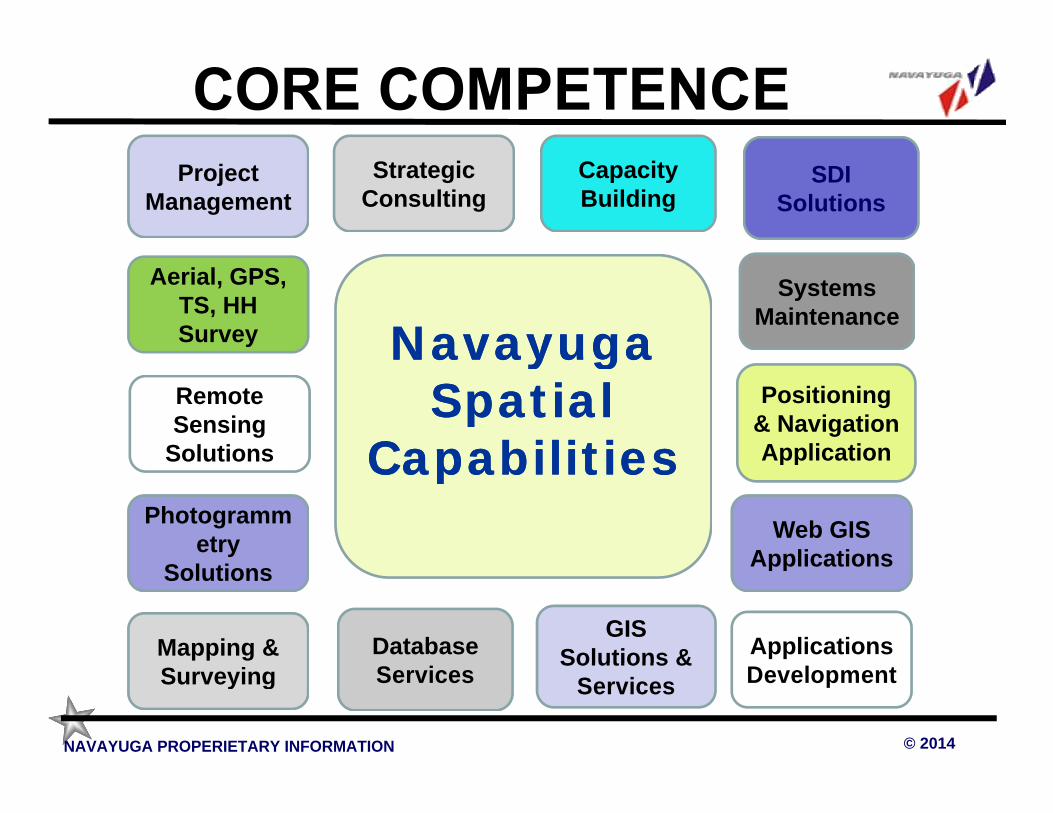
Project Management
SDI Solutions
Capacity Building
Strategic Consulting
Aerial, GPS, TS, HH Survey
Systems Maintenance
Navayuga Navayuga Remote Sensing
Solutions
Positioning & Navigation Application
Navayuga Navayuga Spat ia l Spat ia l
Capabilit iesCapabilit iesSolutions
Photogrammetry
Solutions
Application
Web GIS Applications
Capabilit iesCapabilit ies
Solutions
Mapping & Surveying
Database Services
GIS Solutions & Applications
Development
Applications
© 2014NAVAYUGA PROPERIETARY INFORMATION
Surveying ServicesSolutions &
Services Development

As of 1980 the scope of mapping also began to include cadastral mapping, as a basis for
land management issues.land management issues.
© 2014NAVAYUGA PROPERIETARY INFORMATION

STATUS OF MAPPING IN THE WORLDScale/ range 1:25 000 1:50 000 1:100 000 1:200 000 Scale/ range 1:25 000 1:50 000 1:100 000 1:200 000
Africa 2.9 % 41.4 % 21.7 % 89.1 %
Asia 15.2 % 84 % 56,4 % 100 % Asia 15.2 % 84 % 56,4 % 100 %
Australia and Oceania
18.3 % 24.3 % 54.4 % 100 % Oceania
Europe 86.9 % 96,2 % 87,5 % 90,9 %
Former USSR 100 % 100 % 100 % 100 %
North America 54.1 % 77.7 % 37.3 % 99.2 %
South America 7 % 33 % 57.9 % 84.4 %
World 33.5 % 65.6 % 55.7 % 95.1 %
© 2014NAVAYUGA PROPERIETARY INFORMATION
SOURCE: SOURCE: UNITED NATIONS E/CONF.103/4/Add.1 : 9 July 2013

PUBLIC AVAILABILITY OF MAPSAnswers to 2012 Questionnaire Survey to UN Member Countries
Without Restriction(65)Major Restrictions (71)
© 2014NAVAYUGA PROPERIETARY INFORMATION
SOURCE: SOURCE: UNITED NATIONS E/CONF.103/4/Add.1 : 9 July 2013SOURCE: SOURCE: UNITED NATIONS E/CONF.103/4/Add.1 : 9 July 2013
Major Restrictions (71)Not Answered (5)Rest

Use of in-house facilities/outsourcing by NMAsAnswers to 2012 Questionnaire Survey to UN Member Countries
In-House (50)Outsourcing (12)Both (26)
© 2014NAVAYUGA PROPERIETARY INFORMATION
SOURCE: SOURCE: UNITED NATIONS E/CONF.103/4/Add.1 : 9 July 2013SOURCE: SOURCE: UNITED NATIONS E/CONF.103/4/Add.1 : 9 July 2013
Both (26)Not Answered(3)Rest

NATIONAL CADASTRAL COVERAGE FOR THE COUNTRYAnswers to 2012 Questionnaire Survey to UN Member Countries
Yes (58)No (77)
© 2014NAVAYUGA PROPERIETARY INFORMATION
SOURCE: SOURCE: UNITED NATIONS E/CONF.103/4/Add.1 : 9 July 2013
No (77)Not Answered (5)Rest

SOURCE: Department of Land Resources,
Ministry of Rural Development, Government of Indiahttp://nlrmp.nic.in/faces/common/home.xhtml
© 2014NAVAYUGA PROPERIETARY INFORMATION

Current Status Data Entry (No.Villages)
Source : Ministry of Rural Dev., GoI
© 2014NAVAYUGA PROPERIETARY INFORMATION
Source : Ministry of Rural Dev., GoI

Source : Ministry of Rural Dev., GoI
© 2014NAVAYUGA PROPERIETARY INFORMATION

Cadastral Map Digitization (Nos. of Villages)
Source : Ministry of Rural Dev., GoI
© 2014NAVAYUGA PROPERIETARY INFORMATION

An Initiative of Govt of DelhiAn Initiative of Govt of Delhi(Details shown in this section with Courtesy of MD/Geospatial Delhi Limited)
© 2014NAVAYUGA PROPERIETARY INFORMATION

• Seamless Mosaic of Masavi for entire State of Delhi • Seamless Mosaic of Masavi for entire State of Delhi comprising of 357 villages
• Overlaying and Integration with Topographic base/ortho • Overlaying and Integration with Topographic base/ortho photo and generation of cadastral layer on scale of 1:2000 thereby improving the accuracy of the village boundaries now linked to the National Topographic datumboundaries now linked to the National Topographic datum
• Village trijunction & boundary pillars identified. Many of these were several decades old and positioned at the these were several decades old and positioned at the time of original survey.
• Patwaris have updated almost 98% of records/ mutations• Patwaris have updated almost 98% of records/ mutations• All the spatial and non spatial information has been
integrated in a single platform in GIS format facilitating easy updation
© 2014NAVAYUGA PROPERIETARY INFORMATION
easy updation

Georeferencing of Masavi with Orthophoto
© 2014NAVAYUGA PROPERIETARY INFORMATION

Digitization of Parcel Layer
© 2014NAVAYUGA PROPERIETARY INFORMATION

Village Trijunction & Boundary Pillar Identified
Tri Junction Pillar Boundary PillarTri Junction Pillar Boundary Pillar
© 2014NAVAYUGA PROPERIETARY INFORMATION

Updation by Patwaris to the Extent of 98%
© 2014NAVAYUGA PROPERIETARY INFORMATION

© 2014NAVAYUGA PROPERIETARY INFORMATION

© 2014NAVAYUGA PROPERIETARY INFORMATION

Source : www.ordnancesurvey.co.uk/
© 2014NAVAYUGA PROPERIETARY INFORMATION 2323

• 216 years old, 1446 staffs, reports to• 216 years old, 1446 staffs, reports toGovernment
•• After 35 years of continued losses, Ordnance Survey made Trading Fund in 1999
• TARGET SET BY GOVT: 9% return • TARGET SET BY GOVT: 9% return on capital employed in 5 years. Revenue to exceed cost and Revenue to exceed cost and surpluses can be invested back but dividend to be paid to Govt.
© 2014NAVAYUGA PROPERIETARY INFORMATION 2424
dividend to be paid to Govt.

• Major investment program hallmark of Ordnance• Major investment program hallmark of OrdnanceSurvey in recent years
• Around 25% of trading revenue has been• Around 25% of trading revenue has beeninvested in the business since 1999• Infrastructure investments as enablers for
improved data consistency, interoperability andsupply
• Capability investments in staff and physical• Capability investments in staff and physicalfabric reflecting our evolution from a mapfactory to an information organizationfactory to an information organization
• Relationship investments – growing ourability to satisfy our customers, partners and
© 2014NAVAYUGA PROPERIETARY INFORMATION 2525
ability to satisfy our customers, partners andstakeholders

• National Positional Accuracy • National Positional Accuracy Improvement (PAI) Program to improve absolute accuracy of existing TOPO-96 data as well as its updatedata as well as its update
• Absolute Accuracy Target
Built up areas in rural towns (+ 0.4 meter RMSE)Built up areas in rural towns (+ 0.4 meter RMSE)
Outside built up areas(+ 1.1 meter RMSE)
• Relative Accuracy Target: + 0.4 meter RMSE
© 2014NAVAYUGA PROPERIETARY INFORMATION
RMSE
2626

Tendering & Program Implementation
• Expression of Interest Invited on 13th September 2001
• Scope: 225,000 Sq-KMs of Large Scale Mapping • Scope: 225,000 Sq-KMs of Large Scale Mapping involving Aerial photography, Ground Control Points, AT, DTM & Ortho-photo generation, Positional AT, DTM & Ortho-photo generation, Positional Accuracy Improvement (PAI) and capturing real world change (RWC), Field verification, Delivery of world change (RWC), Field verification, Delivery of final product via Internet
• Techno-commercial evaluation led to selection of 3 • Techno-commercial evaluation led to selection of 3 vendors
• Program started in 2001 and got completed in 2006.
© 2014NAVAYUGA PROPERIETARY INFORMATION
• Program started in 2001 and got completed in 2006.
2727

Ordnance Survey – on demand• 60,000 to 74,000 • 60,000 to 74,000
requests per month • 5,000 requests per day • 5,000 requests per day
for map images.• Average response time
for a map image to be returned to a user was less than 0.6 seconds less than 0.6 seconds with even the most detailed OS MasterMapdetailed OS MasterMapimages returned in little over a second.
© 2014NAVAYUGA PROPERIETARY INFORMATION 2828
over a second.

• 1984-86 - Cadastral register computerized• 1984-86 - Cadastral register computerized• 1997 - Cadastral maps digitized• 2000 - internet ready GIS for whole
of Denmarkof Denmark– Building & Dwelling Register– Municipal Register of Property– Municipal Register of Property– Cadastral Register– Register of Plans– Register of Plans
– The Land Book
© 2014NAVAYUGA PROPERIETARY INFORMATION
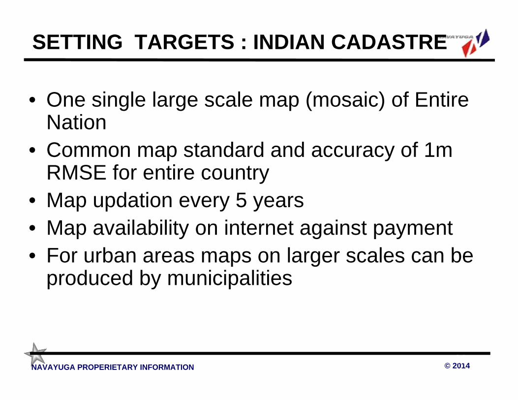
SETTING TARGETS : INDIAN CADASTRE
• One single large scale map (mosaic) of Entire NationNation
• Common map standard and accuracy of 1m RMSE for entire countryRMSE for entire country
• Map updation every 5 years• Map availability on internet against payment • Map availability on internet against payment • For urban areas maps on larger scales can be
produced by municipalitiesproduced by municipalities
© 2014NAVAYUGA PROPERIETARY INFORMATION 3030

Task Magnitude:1 m accuracy Map
• 5 years mapping program would require – About 6 lakh sq km of mapping per year on 1:2500
scale with 1.0 meter RMSE accuracy scale with 1.0 meter RMSE accuracy – Rs 5000 crores or about Rs 1000 crores per year of
financing – Delivery of 1 lakh sq kms of maps by each partner
every year
• Deployment 40,000 production staff from • Deployment 40,000 production staff from Industry to achieve the desired targets
• Survey of India : • Survey of India : – to undertake quality assurance and quality control
activities and be custodian of the map
© 2014NAVAYUGA PROPERIETARY INFORMATION
activities and be custodian of the map – would require doubling of its present strength
3131

• Direct Sale (via Internet and counters)• Private Sector Partners• Distribution• Distribution• Publishing
© 2014NAVAYUGA PROPERIETARY INFORMATION 3232

Public Private Partnership
• SOI to undertake public consultation : map • SOI to undertake public consultation : map standards, IT & GIS modules, internet bases techniques accuracy levels and type of PPP modeltechniques accuracy levels and type of PPP model
• Project Financing through Public Private Partnership model targeting 15% Project IRR. This will ensure the required debt and equity flows This will ensure the required debt and equity flows to the project without any budgetary supports
• Competitive bidding to select about 6 strong Indian • Competitive bidding to select about 6 strong Indian vendors who can if required have international partners and willing to form Special Purpose Vehicle/s for Public Private Partnership with Survey Vehicle/s for Public Private Partnership with Survey of India
• For urban areas maps on larger scales can be
© 2014NAVAYUGA PROPERIETARY INFORMATION
• For urban areas maps on larger scales can be produced by municipalities on similar approach
3333

Countries that have connected Land Administration Systems to spatial Countries that have connected Land Administration Systems to spatial data infrastructure (SDI) and allowed it to function in the environment of an E-government and spatially enabled society have gained maximum benefits such as:benefits such as:– Direct Benefit:
Legal security (basic requirement for investors and credibility);Access to credit (mortgage);Access to credit (mortgage);Spatial planning (consumers, producers);Full Taxation leading to higher revenues (on property and land);Decision making support system for Government and Private Sector.Decision making support system for Government and Private Sector.
– Indirect Benefit:Justice (cultural, ethnical, gender, wealth);Good governance and transparency.Good governance and transparency.Environmental impact assessment;
In the Indian Context PPP model targeting 15% Project IRR can generate required fund to complete the project in 5 years
© 2014NAVAYUGA PROPERIETARY INFORMATION
required fund to complete the project in 5 years
Recommended


![Digitization Challenges for [Jewish] Genealogy](https://img.pdfslide.tips/doc/110x75/56814948550346895db693e4/digitization-challenges-for-jewish-genealogy.jpg)