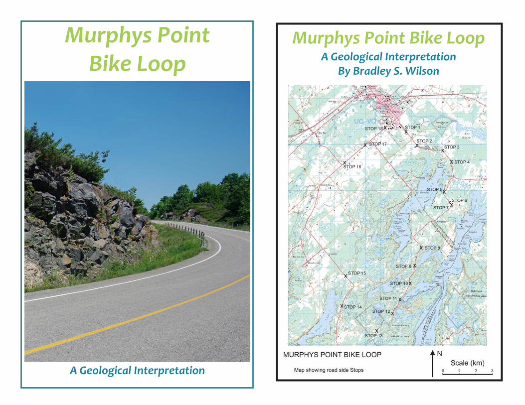
Murphys Point Bike Loop
A Geological Interpretation
Murphys Point Bike LoopA Geological Interpretation
By Bradley S. Wilson
x
STOP 4
x
STOP 3
STOP 11
STOP 8
STOP 7
STOP 1
x
x
x
x
x
x
STOP 2x
STOP 5
x
x
xSTOP 6
STOP 9
STOP 15
x
x
STOP 17
STOP 13
STOP 18
STOP 16
x
x
STOP 14
x
x
STOP 12
STOP 10
Scale (km)0 1 2 3
NMURPHY’S POINT BIKE LOOP
Map showing road side Stops
2
geologists try to unravel geologic history by analysing evidence in the rocks beneath our feet. To a geologist, the earth around us is made up of a lot more than just static lumps of mute rock. Rocks and landscapes can tell stories about our planet’s past and about ancient life in times before humans. Rocks can serve as monuments that mark past events, both calm and violent, in earth’s long history. We only need to take the time to observe and listen. Early Years
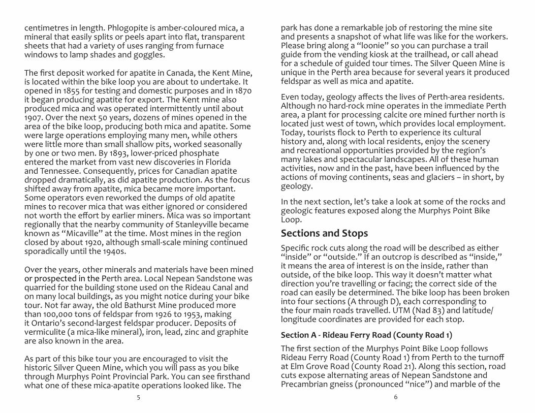
The rocks of the Grenville Province represent the roots of an ancient mountain range. How did this happen? Between 1.8 and 1.3 billion years ago the Perth area was covered by a shallow tropical sea. As mountains near present-day Sudbury on a landmass called “Laurentia” eroded, the resulting sediment was washed into this sea. Sedimentary rocks, such as sandstone, shale, conglomerate and limestone, were the result. What happened next changed these sedimentary rocks into the metamorphic rocks we see here today. Between 1.3 billion and 950 million years ago, tectonic forces brought landmasses together to form the super-continent “Rodina.” The sedimentary rocks were caught between slowly colliding continents, resulting in the building of the Grenville Mountains – a range whose height would have rivalled the modern-day Himalayas. During this process igneous rocks were introduced and rocks in the deepest part of these mountains changed or metamorphosed in response to the intense heat and pressure they experienced from burial. What was once a series of flat-lying sedimentary rocks became a tilted, folded mixture of metamorphic and igneous rocks.
By about 500 million years ago these mountains had eroded to their roots, exposing a landscape of relatively low relief, very similar to what we see before us today. Next, shallow tropical seas invaded the land during a period of high ocean levels. The seas brought with them sand in the form of widespread beaches, dunes and deltas, which later became the Nepean Sandstone. Tracks in the sand called climactichnites, believed to be made by a primitive mollusc, and tracks belonging to an arthropod known as euthycarcinoid have been found in nearby quarries. Be sure
Murphys Point Bike Loop
1
IntroductionThe geology exposed along the Murphys Point Bike Loop represents more than 1 billion years of Earth’s 4.6-billion-year history. This geology had a profound effect on the lives of early European settlers and continues to influence our lives in different ways.
There are two basic groups of rock found in the Perth area. The first is a series of highly folded and deformed metamorphic and igneous rocks of Precambrian age, about 1 billion years old, that are part of what is called the “Grenville Province.” The vast Canadian Shield is made up of groups of rocks called provinces that each share similar time periods and tectonic features. The Grenville Province, which extends from southern Ontario north of the St. Lawrence River through Quebec and southern Labrador, is the youngest of these provinces. The second group of rocks has only one representative along the bike loop: a relatively undisturbed, flat-lying sandstone of late Cambrian-early Ordovician age (about 500 million years old) called the “Nepean Sandstone.” Lying on top of these rocks are unconsolidated sediments left behind after continental glaciers melted away from this area about 11,500 years ago.
To state “these are the rocks found in this area” sounds dull and simplistic. After all, geology is about a lot more than just “rocks” – it’s also about deciphering events in Earth’s history. Like a detective investigating clues while solving a mystery,
The Tour
Length: Approximately 40 kilometres Duration: About three hours Difficulty: Difficult Note: Take only photos! Please do not remove rock samples at the stops so there will be something for those who follow to see! Safety: Cycle at your own risk. There are no designated cycling lanes on this route. Please obey the rules of the road and watch for traffic.
3
to look at the climactichnites fossil on display at the Perth Museum while you’re here.
Geologic evidence found elsewhere in the region indicates these shallow tropical seas persisted for at least another 20 to 30 million years, depositing additional layers of dolomite and limestone. In the Perth area the overlying sedimentary rocks experienced erosion, such that what remains today is a thin, discontinuous, veneer-like layer of Nepean Sandstone.
1.8 - 1.3 billion years ago
Laurentia(Early-North America)
Shallow Sea(Covering present-day Perth area)
Sandstone, conglomeratemudstone, Limestone
Erosion
Major Events in Eastern Ontario’s Early Geological HistorySchematic (not to scale)
1.3 billion - 950 million years ago
Laurentia(Early-North America)
Grenville Orogeny
IgneousPlutonsIgneous
Dykes
Metamorphic gneiss, schist,quartzite, and marble
Ocean
500 million years ago
Laurentia(Early-North America)
Grenville Province
IgneousPlutonsIgneous
Dykes Metamorphic gneiss, schist,quartzite, and marble
Shallow Sea
Collision
The eroded roots of the mountains
Laurentian Mountains
Stage 1The Perth area is covered by a shallow ocean. Mountains to the west near Sudbury are eroding and depositing sediments in the sea and along the coast.
Stage 2By 1.3 billion years ago the older mountains were eroded to their roots. Over the next several hundred million years, collisions form the super-continent Rodinia and produce the Grenville Mountain belt.
Stage 3By 500 million years agothe Grenvilles wereeroded to their roots. The rocks now form the youngest part of the Canadian Shield knownas the Grenville Structural Province.
Graphic courtesy of the Miller Museum of Geology, Queen’s University, Kingston, Ontario
Glaciation
The earth began cooling at the beginning of the Quaternary Period, about 2.58 million years ago, marking the beginning of the current “Ice Age.” In the last million years, glaciers covered the Perth area at least four times. The most recent event, called the Wisconsin glaciation, began 110,000 years ago and reached its maximum extent a mere 18,000 years ago. Covering most of Canada and extending into the northern United States, this continental glacier reached a
4
thickness of three to four kilometres. After a complex history of advances and retreats that blocked rivers, created ice-dammed lakes and deposited much sediment, the ice finally left the Perth area about 11,500 years ago.
As the ice moved across the land it scoured, gouged and scraped bedrock in some areas while depositing a seemingly chaotic mix of unconsolidated sediment in others. In general, bedrock was rounded, grooved and striated by the moving weight of the overlying ice. Areas with underlying Precambrian rock were shaped into the rugged landscape we see today consisting of numerous lakes and rocky ridges – a result of the differential erosion of hard and soft rock. Geological Influences on Human Activity in the Perth Area
As long as humans have lived and travelled in the Perth region, local geology has had an impact on their lives. Archaeological evidence suggests the earliest inhabitants lived near lake shores and travelled primarily by dugout canoe, thanks to the abundance of lakes created by the glaciers.
After the arrival of the first European settlers the local geology played an even larger role in the human experience. Many early settlers came here to start a new life of farming. Although flat-lying areas underlain by Nepean Sandstone had sparse soil development, they were generally satisfactory for farming. Areas having deposits of glacial sediment usually made good farmland, whereas those underlain by the rocky and rugged Precambrian Canadian Shield did not. Landowners and would-be farmers saddled with a piece of Canadian Shield instead of good farmland might have considered themselves unlucky, but here’s where geology changed some fortunes. Within the Precambrian bedrock that made their land so hard to farm, significant quantities of the minerals phlogopite (mica) and apatite were discovered. Thus began an era of mining.
Apatite was used as a source of phosphate in the manufacture of fertilizer. It typically occurs as blue-green sugary aggregates or as hexagonal crystals up to 30
5
centimetres in length. Phlogopite is amber-coloured mica, a mineral that easily splits or peels apart into flat, transparent sheets that had a variety of uses ranging from furnace windows to lamp shades and goggles. The first deposit worked for apatite in Canada, the Kent Mine, is located within the bike loop you are about to undertake. It opened in 1855 for testing and domestic purposes and in 1870 it began producing apatite for export. The Kent mine also produced mica and was operated intermittently until about 1907. Over the next 50 years, dozens of mines opened in the area of the bike loop, producing both mica and apatite. Some were large operations employing many men, while others were little more than small shallow pits, worked seasonally by one or two men. By 1893, lower-priced phosphate entered the market from vast new discoveries in Florida and Tennessee. Consequently, prices for Canadian apatite dropped dramatically, as did apatite production. As the focus shifted away from apatite, mica became more important. Some operators even reworked the dumps of old apatite mines to recover mica that was either ignored or considered not worth the effort by earlier miners. Mica was so important regionally that the nearby community of Stanleyville became known as “Micaville” at the time. Most mines in the region closed by about 1920, although small-scale mining continued sporadically until the 1940s. Over the years, other minerals and materials have been mined or prospected in the Perth area. Local Nepean Sandstone was quarried for the building stone used on the Rideau Canal and on many local buildings, as you might notice during your bike tour. Not far away, the old Bathurst Mine produced more than 100,000 tons of feldspar from 1926 to 1953, making it Ontario’s second-largest feldspar producer. Deposits of vermiculite (a mica-like mineral), iron, lead, zinc and graphite are also known in the area. As part of this bike tour you are encouraged to visit the historic Silver Queen Mine, which you will pass as you bike through Murphys Point Provincial Park. You can see firsthand what one of these mica-apatite operations looked like. The
6
park has done a remarkable job of restoring the mine site and presents a snapshot of what life was like for the workers. Please bring along a “loonie” so you can purchase a trail guide from the vending kiosk at the trailhead, or call ahead for a schedule of guided tour times. The Silver Queen Mine is unique in the Perth area because for several years it produced feldspar as well as mica and apatite.
Even today, geology affects the lives of Perth-area residents. Although no hard-rock mine operates in the immediate Perth area, a plant for processing calcite ore mined further north is located just west of town, which provides local employment. Today, tourists flock to Perth to experience its cultural history and, along with local residents, enjoy the scenery and recreational opportunities provided by the region’s many lakes and spectacular landscapes. All of these human activities, now and in the past, have been influenced by the actions of moving continents, seas and glaciers – in short, by geology.
In the next section, let’s take a look at some of the rocks and geologic features exposed along the Murphys Point Bike Loop.
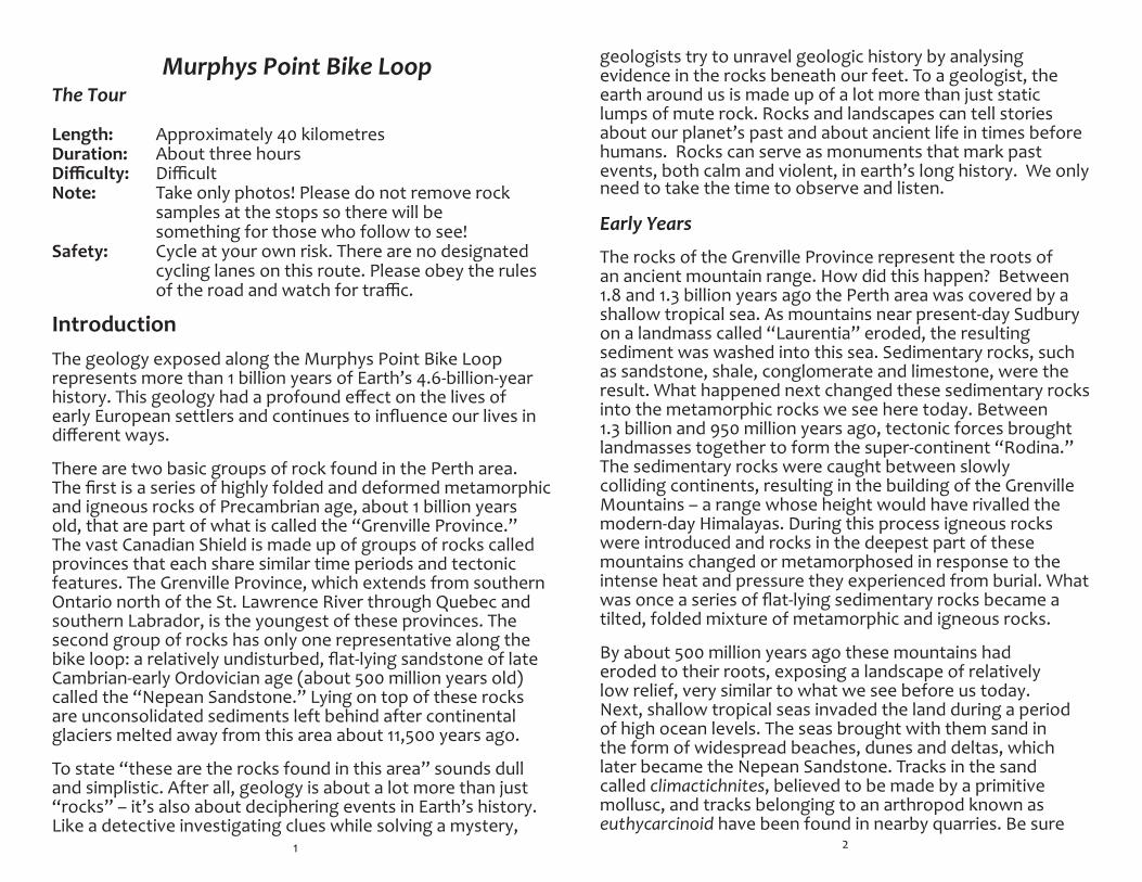
Sections and StopsSpecific rock cuts along the road will be described as either “inside” or “outside.” If an outcrop is described as “inside,” it means the area of interest is on the inside, rather than outside, of the bike loop. This way it doesn’t matter what direction you’re travelling or facing; the correct side of the road can easily be determined. The bike loop has been broken into four sections (A through D), each corresponding to the four main roads travelled. UTM (Nad 83) and latitude/longitude coordinates are provided for each stop. SectionA-RideauFerryRoad(CountyRoad1) The first section of the Murphys Point Bike Loop follows Rideau Ferry Road (County Road 1) from Perth to the turnoff at Elm Grove Road (County Road 21). Along this section, road cuts expose alternating areas of Nepean Sandstone and Precambrian gneiss (pronounced “nice”) and marble of the
7
Grenville Province. Nepean Sandstone crops out as a thin, discontinuous skin or layer of rock that lies on top of the complex Precambrian metamorphic rocks.
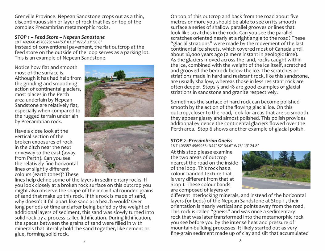
STOP 1 – Feed Store – Nepean Sandstone
Instead of conventional pavement, the flat outcrop at the feed store on the outside of the loop serves as a parking lot. This is an example of Nepean Sandstone.
Notice how flat and smooth most of the surface is. Although it has had help from the grinding and smoothing action of continental glaciers, most places in the Perth area underlain by Nepean Sandstone are relatively flat, especially when compared to the rugged terrain underlain by Precambrian rock.
Have a close look at the vertical section of the broken exposures of rock in the ditch near the next driveway to the east (away from Perth). Can you see the relatively fine horizontal lines of slightly different colours (earth tones)? These lines help define some of the layers in sedimentary rocks. If you look closely at a broken rock surface on this outcrop you might also observe the shape of the individual rounded grains of sand that make up this rock. If this rock is made of sand, why doesn’t it fall apart like sand at a beach would? Over long periods of time and after being buried by the weight of additional layers of sediment, this sand was slowly turned into solid rock by a process called lithification. During lithification, the spaces between the grains of sand were filled in with minerals that literally hold the sand together, like cement or glue, forming solid rock.
18 T 402668 4970828; N44°53’ 03.2” W76° 13’ 56.8”
8
On top of this outcrop and back from the road about five metres or more you should be able to see on its smooth surface a series of shallow parallel grooves or lines that look like scratches in the rock. Can you see the parallel scratches oriented nearly at a right angle to the road? These “glacial striations” were made by the movement of the last continental ice sheets, which covered most of Canada until about 18,000 years ago (a mere instant in geologic time). As the glaciers moved across the land, rocks caught within the ice, combined with the weight of the ice itself, scratched and grooved the bedrock below the ice. The scratches or striations made in hard and resistant rock, like this sandstone, are usually shallow, whereas those in less resistant rock are often deeper. Stops 5 and 18 are good examples of glacial striations in sandstone and granite respectively.
Sometimes the surface of hard rock can become polished smooth by the action of the flowing glacial ice. On this outcrop, closer to the road, look for areas that are so smooth they appear glassy and almost polished. This polish provides additional evidence the continental glaciers flowed over the Perth area. Stop 6 shows another example of glacial polish. STOP 2–Precambrian Gneiss At this stop please examine the two areas of outcrop nearest the road on the inside of the loop. This rock has a colour-banded texture that is very different from that at Stop 1. These colour bands are composed of layers of different interlocking minerals, and instead of the horizontal layers (or beds) of the Nepean Sandstone at Stop 1 , their orientation is nearly vertical and points away from the road. This rock is called “gneiss” and was once a sedimentary rock that was later transformed into the metamorphic rock you see before you by the intense heat and pressure of mountain-building processes. It likely started out as very fine-grain sediment made up of clay and silt that accumulated
18 T 403357 4969933; N44° 52’ 34.6” W76° 13’ 24.8”
9
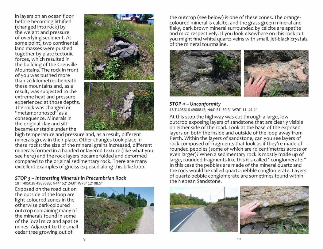
in layers on an ocean floor before becoming lithified (changed into rock) by the weight and pressure of overlying sediment. At some point, two continental land masses were pushed together by plate tectonic forces, which resulted in the building of the Grenville Mountains. The rock in front of you was pushed more than 20 kilometres beneath these mountains and, as a result, was subjected to the extreme heat and pressure experienced at those depths. The rock was changed or “metamorphosed” as a consequence. Minerals in the original clay and silt became unstable under the high temperature and pressure and, as a result, different minerals grew in their place. Other changes took place in these rocks: the size of the mineral grains increased, different minerals formed in a banded or layered texture (like what you see here) and the rock layers became folded and deformed compared to the original sedimentary rock. There are many excellent examples of gneiss exposed along this bike loop. STOP 3 – Interesting Minerals in Precambrian Rock
Exposed on the road cut on the outside of the loop are light-coloured zones in the otherwise dark-coloured outcrop containing many of the minerals found in some of the local mica and apatite mines. Adjacent to the small cedar tree growing out of
18 T 405028 4969583; N44° 52’ 24.0” W76° 12’ 08.5”
10
the outcrop (see below) is one of these zones. The orange-coloured mineral is calcite, and the grass green mineral and flaky, dark brown mineral surrounded by calcite are apatite and mica respectively. If you look elsewhere on this rock cut you might find white quartz veins with small, jet-black crystals of the mineral tourmaline.
At this stop the highway was cut through a large, low outcrop exposing layers of sandstone that are clearly visible on either side of the road. Look at the base of the exposed layers on both the inside and outside of the loop away from Perth. Within the layers of sandstone, can you see layers of rock composed of fragments that look as if they’re made of rounded pebbles (some of which are 10 centimetres across or even larger)? When a sedimentary rock is mostly made up of large, rounded fragments like this it’s called “conglomerate.” In this case the pebbles are made of the mineral quartz and the rock would be called quartz-pebble conglomerate. Layers of quartz-pebble conglomerate are sometimes found within the Nepean Sandstone.
18 T 405616 4968812; N44° 51’ 59.3” W76° 11’ 41.1”STOP 4 – Unconformity
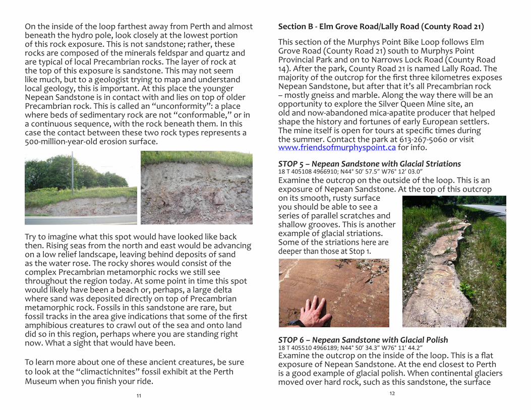
On the inside of the loop farthest away from Perth and almost beneath the hydro pole, look closely at the lowest portion of this rock exposure. This is not sandstone; rather, these rocks are composed of the minerals feldspar and quartz and are typical of local Precambrian rocks. The layer of rock at the top of this exposure is sandstone. This may not seem like much, but to a geologist trying to map and understand local geology, this is important. At this place the younger Nepean Sandstone is in contact with and lies on top of older Precambrian rock. This is called an “unconformity”: a place where beds of sedimentary rock are not “conformable,” or in a continuous sequence, with the rock beneath them. In this case the contact between these two rock types represents a 500-million-year-old erosion surface.
Try to imagine what this spot would have looked like back then. Rising seas from the north and east would be advancing on a low relief landscape, leaving behind deposits of sand as the water rose. The rocky shores would consist of the complex Precambrian metamorphic rocks we still see throughout the region today. At some point in time this spot would likely have been a beach or, perhaps, a large delta where sand was deposited directly on top of Precambrian metamorphic rock. Fossils in this sandstone are rare, but fossil tracks in the area give indications that some of the first amphibious creatures to crawl out of the sea and onto land did so in this region, perhaps where you are standing right now. What a sight that would have been. To learn more about one of these ancient creatures, be sure to look at the “climactichnites” fossil exhibit at the Perth Museum when you finish your ride.
11
SectionB-ElmGroveRoad/LallyRoad(CountyRoad21)
This section of the Murphys Point Bike Loop follows Elm Grove Road (County Road 21) south to Murphys Point Provincial Park and on to Narrows Lock Road (County Road 14). After the park, County Road 21 is named Lally Road. The majority of the outcrop for the first three kilometres exposes Nepean Sandstone, but after that it’s all Precambrian rock – mostly gneiss and marble. Along the way there will be an opportunity to explore the Silver Queen Mine site, an old and now-abandoned mica-apatite producer that helped shape the history and fortunes of early European settlers. The mine itself is open for tours at specific times during the summer. Contact the park at 613-267-5060 or visit www.friendsofmurphyspoint.ca for info.
STOP 5 – Nepean Sandstone with Glacial Striations
Examine the outcrop on the outside of the loop. This is an exposure of Nepean Sandstone. At the top of this outcrop on its smooth, rusty surface you should be able to see a series of parallel scratches and shallow grooves. This is another example of glacial striations. Some of the striations here are deeper than those at Stop 1.
STOP 6 – Nepean Sandstone with Glacial Polish
Examine the outcrop on the inside of the loop. This is a flat exposure of Nepean Sandstone. At the end closest to Perth is a good example of glacial polish. When continental glaciers moved over hard rock, such as this sandstone, the surface
12
18 T 405108 4966910; N44° 50’ 57.5” W76° 12’ 03.0”
18 T 405510 4966189; N44° 50’ 34.3” W76° 11’ 44.2”
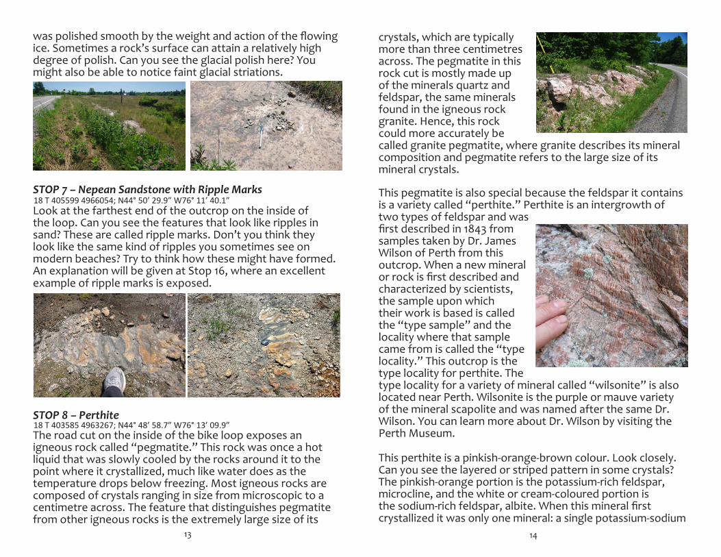
crystals, which are typically more than three centimetres across. The pegmatite in this rock cut is mostly made up of the minerals quartz and feldspar, the same minerals found in the igneous rock granite. Hence, this rock could more accurately be called granite pegmatite, where granite describes its mineral composition and pegmatite refers to the large size of its mineral crystals. This pegmatite is also special because the feldspar it contains is a variety called “perthite.” Perthite is an intergrowth of two types of feldspar and was first described in 1843 from samples taken by Dr. James Wilson of Perth from this outcrop. When a new mineral or rock is first described and characterized by scientists, the sample upon which their work is based is called the “type sample” and the locality where that sample came from is called the “type locality.” This outcrop is the type locality for perthite. The type locality for a variety of mineral called “wilsonite” is also located near Perth. Wilsonite is the purple or mauve variety of the mineral scapolite and was named after the same Dr. Wilson. You can learn more about Dr. Wilson by visiting the Perth Museum. This perthite is a pinkish-orange-brown colour. Look closely. Can you see the layered or striped pattern in some crystals? The pinkish-orange portion is the potassium-rich feldspar, microcline, and the white or cream-coloured portion is the sodium-rich feldspar, albite. When this mineral first crystallized it was only one mineral: a single potassium-sodium
14
was polished smooth by the weight and action of the flowing ice. Sometimes a rock’s surface can attain a relatively high degree of polish. Can you see the glacial polish here? You might also be able to notice faint glacial striations.
STOP 7 – Nepean Sandstone with Ripple Marks
Look at the farthest end of the outcrop on the inside of the loop. Can you see the features that look like ripples in sand? These are called ripple marks. Don’t you think they look like the same kind of ripples you sometimes see on modern beaches? Try to think how these might have formed. An explanation will be given at Stop 16, where an excellent example of ripple marks is exposed.
STOP 8 – Perthite
The road cut on the inside of the bike loop exposes an igneous rock called “pegmatite.” This rock was once a hot liquid that was slowly cooled by the rocks around it to the point where it crystallized, much like water does as the temperature drops below freezing. Most igneous rocks are composed of crystals ranging in size from microscopic to a centimetre across. The feature that distinguishes pegmatite from other igneous rocks is the extremely large size of its
13
18 T 403585 4963267; N44° 48’ 58.7” W76° 13’ 09.9”
18 T 405599 4966054; N44° 50’ 29.9” W76° 11’ 40.1”
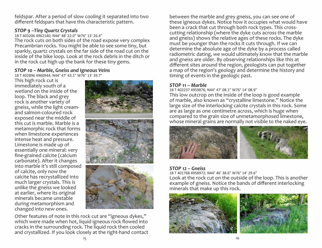
feldspar. After a period of slow cooling it separated into two different feldspars that have this characteristic pattern. STOP 9 –Tiny Quartz Crystals The rock cuts on both sides of the road expose very complex Precambrian rocks. You might be able to see some tiny, but sparkly, quartz crystals on the far side of the road cut on the inside of the bike loop. Look at the rock debris in the ditch or in the rock cut high up the bank for these tiny gems. STOP 10 – Marble, Gneiss and Igneous Veins This high rock cut is immediately south of a wetland on the inside of the loop. The black and grey rock is another variety of gneiss, while the light cream- and salmon-coloured rock exposed near the middle of this cut is marble. Marble is a metamorphic rock that forms when limestone experiences intense heat and pressure. Limestone is made up of essentially one mineral: very fine-grained calcite (calcium carbonate). After it changes into marble it’s still composed of calcite, only now the calcite has recrystallized into much larger crystals. This is unlike the gneiss we looked at earlier, where its original minerals became unstable during metamorphism and changed into new ones. Other features of note in this rock cut are “igneous dykes,” which were made when hot, liquid igneous rock flowed into cracks in the surrounding rock. The liquid rock then cooled and crystallized. If you look closely at the right-hand contact
15
18 T 402896 4960944; N44° 47’ 43.1” W76° 13’ 39.7”
18 T 403206 4962140; N44° 48’ 22.0” W76° 13’ 26.4”
between the marble and grey gneiss, you can see one of these igneous dykes. Notice how it occupies what would have been a crack that cut through both rock types. This cross-cutting relationship (where the dyke cuts across the marble and gneiss) shows the relative ages of these rocks. The dyke must be younger than the rocks it cuts through. If we can determine the absolute age of the dyke by a process called radiometric dating, we would ultimately know that the marble and gneiss are older. By observing relationships like this at different sites around the region, geologists can put together a map of the region’s geology and determine the history and timing of events in the geologic past.
STOP 11 – Marble
This low outcrop on the inside of the loop is good example of marble, also known as “crystalline limestone.” Notice the large size of the interlocking calcite crystals in this rock. Some are as large as one centimetre across, which is huge when compared to the grain size of unmetamorphosed limestone, whose mineral grains are normally not visible to the naked eye.
STOP 12 – Gneiss
Look at the rock cut on the outside of the loop. This is another example of gneiss. Notice the bands of different interlocking minerals that make up this rock.
16
18 T 402237 4959876; N44° 47’ 08.1” W76° 14’ 08.9”
18 T 401768 4958972; N44° 46’ 38.6” W76° 14’ 29.6”
This is the start of the Silver Queen Mine Trail. You may have already noticed you are within Murphys Point Provincial Park. Most trails within the park are off limits to bicycles, but this trail is one of the few where bikes are allowed. At the trailhead kiosk you can purchase a map and trail guide for $1 (loonies only). The guide contains lots of interesting information along with period photos and is well worth the investment!
Across the road is a parking area and an outhouse. Adjacent to the parking lot you can see several low outcrops with good exposures of marble.
The Silver Queen Mine began producing mica in 1903 and apatite a short time later. In 1911, feldspar production began from an adjacent deposit and was mined until the start of World War I in 1914.
The area around Perth has seen many mines come and go and in the late 1800s and early 1900s was well known for its many mica and apatite mines, none of which is in operation today. Some of these mines closed because they ran out of ore, while others shut down due to economic conditions beyond anyone’s control. Dozens of these old and now-abandoned mines are located within a few kilometres of the roads you bicycle on today.
As you travel from here to the next section, the rock cuts you see are a mix of mostly marble and garnet gneiss.
17
18 T 400715 4957914; N44° 46’ 03.8” W76° 15’ 16.8”
18 T 398478 4959478; N44° 46’ 53.4” W76° 16’ 59.6”
STOP 14 – Intrusive Contact
SectionC–NarrowsLockRoad(CountyRoad14)This portion of the bike loop is paved and leads past road cuts composed of a mix of marble, gneiss and sandstone.
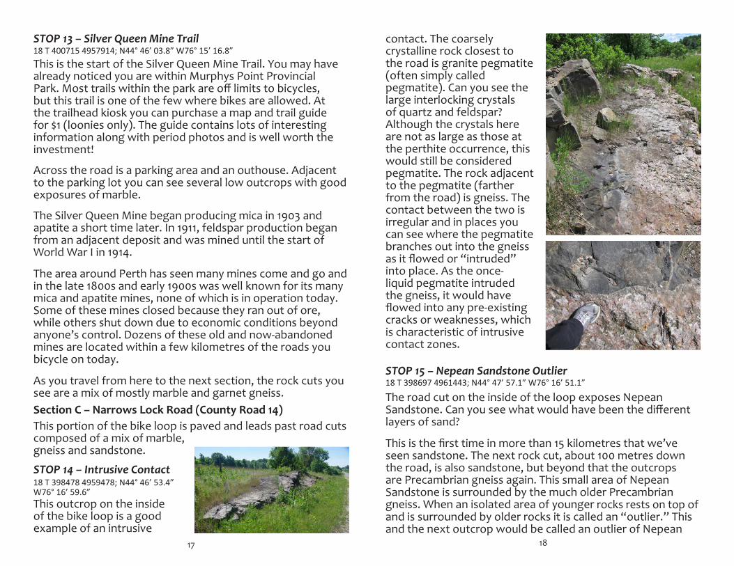
STOP 13 – Silver Queen Mine Trail
This outcrop on the inside of the bike loop is a good example of an intrusive
contact. The coarsely crystalline rock closest to the road is granite pegmatite (often simply called pegmatite). Can you see the large interlocking crystals of quartz and feldspar? Although the crystals here are not as large as those at the perthite occurrence, this would still be considered pegmatite. The rock adjacent to the pegmatite (farther from the road) is gneiss. The contact between the two is irregular and in places you can see where the pegmatite branches out into the gneiss as it flowed or “intruded” into place. As the once-liquid pegmatite intruded the gneiss, it would have flowed into any pre-existing cracks or weaknesses, which is characteristic of intrusive contact zones. The road cut on the inside of the loop exposes Nepean Sandstone. Can you see what would have been the different layers of sand?
This is the first time in more than 15 kilometres that we’ve seen sandstone. The next rock cut, about 100 metres down the road, is also sandstone, but beyond that the outcrops are Precambrian gneiss again. This small area of Nepean Sandstone is surrounded by the much older Precambrian gneiss. When an isolated area of younger rocks rests on top of and is surrounded by older rocks it is called an “outlier.” This and the next outcrop would be called an outlier of Nepean
18
18 T 398697 4961443; N44° 47’ 57.1” W76° 16’ 51.1”STOP 15 – Nepean Sandstone Outlier
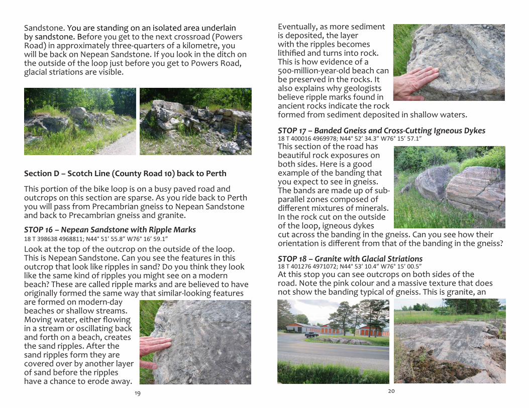
Sandstone. You are standing on an isolated area underlain by sandstone. Before you get to the next crossroad (Powers Road) in approximately three-quarters of a kilometre, you will be back on Nepean Sandstone. If you look in the ditch on the outside of the loop just before you get to Powers Road, glacial striations are visible.
SectionD–ScotchLine(CountyRoad10)backtoPerth
This portion of the bike loop is on a busy paved road and outcrops on this section are sparse. As you ride back to Perth you will pass from Precambrian gneiss to Nepean Sandstone and back to Precambrian gneiss and granite.
Look at the top of the outcrop on the outside of the loop. This is Nepean Sandstone. Can you see the features in this outcrop that look like ripples in sand? Do you think they look like the same kind of ripples you might see on a modern beach? These are called ripple marks and are believed to have originally formed the same way that similar-looking features are formed on modern-day beaches or shallow streams. Moving water, either flowing in a stream or oscillating back and forth on a beach, creates the sand ripples. After the sand ripples form they are covered over by another layer of sand before the ripples have a chance to erode away.
19
18 T 398638 4968811; N44° 51’ 55.8” W76° 16’ 59.1”STOP 16 – Nepean Sandstone with Ripple Marks
20
Eventually, as more sediment is deposited, the layer with the ripples becomes lithified and turns into rock. This is how evidence of a 500-million-year-old beach can be preserved in the rocks. It also explains why geologists believe ripple marks found in ancient rocks indicate the rock formed from sediment deposited in shallow waters.
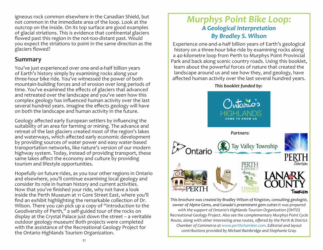
STOP 17 – Banded Gneiss and Cross-Cutting Igneous Dykes
This section of the road has beautiful rock exposures on both sides. Here is a good example of the banding that you expect to see in gneiss. The bands are made up of sub-parallel zones composed of different mixtures of minerals. In the rock cut on the outside of the loop, igneous dykes cut across the banding in the gneiss. Can you see how their orientation is different from that of the banding in the gneiss?
STOP 18 – Granite with Glacial Striations
At this stop you can see outcrops on both sides of the road. Note the pink colour and a massive texture that does not show the banding typical of gneiss. This is granite, an
18 T 400016 4969978; N44° 52’ 34.3” W76° 15’ 57.1”
18 T 401276 4971072; N44° 53’ 10.4” W76° 15’ 00.5”
This brochure was created by Bradley Wilson of Kingston, consulting geologist, owner of Alpine Gems, and Canada’s preeminent gem cutter.It was prepared
with the support of Ontario's Highlands Tourism Organization (OHTO) Recreational Geology Project. Also see the complementary Murphys Point Cycle Route, along with other interesting area routes, offered by the Perth & District
Chamber of Commerce at www.perthchamber.com. Editorial and layout contributions provided by Michael Bainbridge and Stephanie Gray.
Experience one-and-a-half billion years of Earth’s geological history on a three-hour bike ride by examining rocks along
a 40-kilometre loop from Perth to Murphys Point Provincial Park and back along scenic country roads. Using this booklet,
learn about the powerful forces of nature that created the landscape around us and see how they, and geology, have
affected human activity over the last several hundred years.
Murphys Point Bike Loop: A Geological Interpretation
By Bradley S. Wilson
This booklet funded by:
Partners:
igneous rock common elsewhere in the Canadian Shield, but not common in the immediate area of the loop. Look at the outcrop on the inside. On its top surface are good examples of glacial striations. This is evidence that continental glaciers flowed past this region in the not-too-distant past. Would you expect the striations to point in the same direction as the glaciers flowed?
You’ve just experienced over one-and-a-half billion years of Earth’s history simply by examining rocks along your three-hour bike ride. You’ve witnessed the power of both mountain-building forces and of erosion over long periods of time. You’ve examined the effects of glaciers that advanced and retreated over the landscape and you’ve seen how this complex geology has influenced human activity over the last several hundred years. Imagine the effects geology will have on both the landscape and human activity in the future.
Geology affected early European settlers by influencing the suitability of an area for farming or mining. The advance and retreat of the last glaciers created most of the region’s lakes and waterways, which affected early economic development by providing sources of water power and easy water-based transportation networks, like nature’s version of our modern highway system. Today, instead of providing transport, these same lakes affect the economy and culture by providing tourism and lifestyle opportunities.
Hopefully on future rides, as you tour other regions in Ontario and elsewhere, you’ll continue examining local geology and consider its role in human history and current activities. Now that you’ve finished your ride, why not have a look inside the Perth Museum at 11 Gore Street East, where you’ll find an exhibit highlighting the remarkable collection of Dr. Wilson. There you can pick up a copy of “Introduction to the Geodiversity of Perth,” a self-guided tour of the rocks on display at the Crystal Palace just down the street – a veritable outdoor geology museum! Both projects were completed with the assistance of the Recreational Geology Project for the Ontario Highlands Tourism Organization.
21
Summary
Recommended