Embed Size (px)
Citation preview
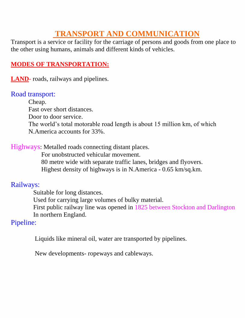
TRANSPORT AND COMMUNICATION Transport is a service or facility for the carriage of persons and goods from one place to
the other using humans animals and different kinds of vehicles
MODES OF TRANSPORTATION
LAND- roads railways and pipelines
Road transport Cheap
Fast over short distances
Door to door service
The worldrsquos total motorable road length is about 15 million km of which
NAmerica accounts for 33
Highways Metalled roads connecting distant places
For unobstructed vehicular movement
80 metre wide with separate traffic lanes bridges and flyovers
Highest density of highways is in NAmerica - 065 kmsqkm
Railways Suitable for long distances
Used for carrying large volumes of bulky material
First public railway line was opened in 1825 between Stockton and Darlington
In northern England
Pipeline
Liquids like mineral oil water are transported by pipelines
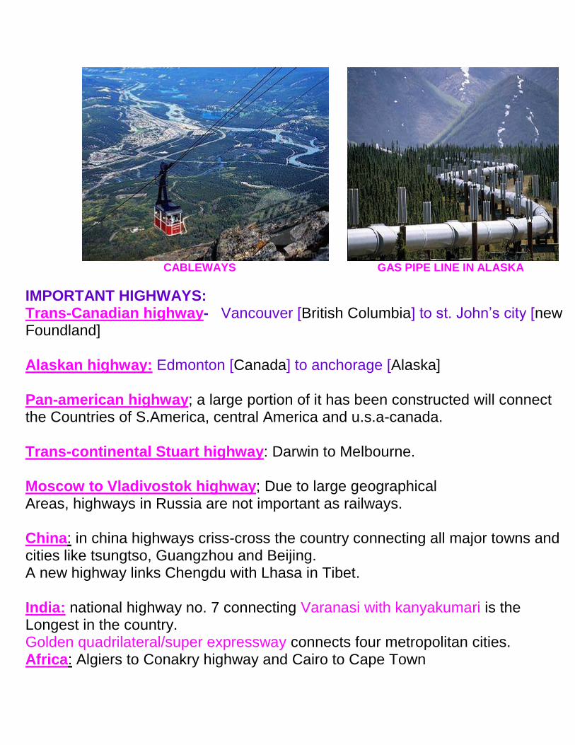
New developments- ropeways and cableways
CABLEWAYS GAS PIPE LINE IN ALASKA
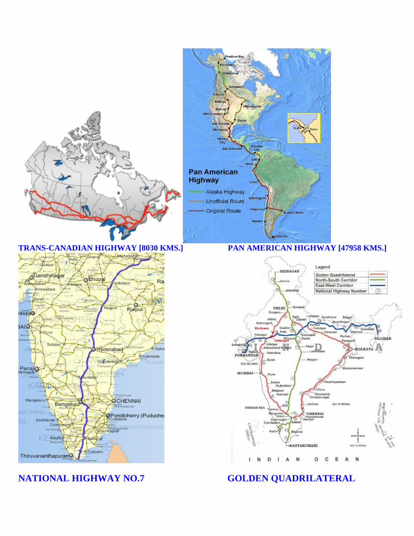
IMPORTANT HIGHWAYS Trans-Canadian highway- Vancouver [British Columbia] to st Johnrsquos city [new Foundland] Alaskan highway Edmonton [Canada] to anchorage [Alaska] Pan-american highway a large portion of it has been constructed will connect the Countries of SAmerica central America and usa-canada Trans-continental Stuart highway Darwin to Melbourne Moscow to Vladivostok highway Due to large geographical Areas highways in Russia are not important as railways China in china highways criss-cross the country connecting all major towns and cities like tsungtso Guangzhou and Beijing A new highway links Chengdu with Lhasa in Tibet India national highway no 7 connecting Varanasi with kanyakumari is the Longest in the country Golden quadrilateralsuper expressway connects four metropolitan cities Africa Algiers to Conakry highway and Cairo to Cape Town
TRANS-CANADIAN HIGHWAY [8030 KMS] PAN AMERICAN HIGHWAY [47958 KMS]
NATIONAL HIGHWAY NO7 GOLDEN QUADRILATERAL
Border roads laid along international boundaries
RAILWAYS
The railways gauges vary in different countries and are classified as-
Broad gauge - gt 15 metres
Standard gauge - 144 metres
Metre gauge - 10 metre
Small gauge - lt 10 metre
EUROPE 4 40000 km of railways
Belgium has the highest density of 1km of railway for every 65 sqkms area
Channel tunnel connects London and Paris
RUSSIA ndashrailways accounts for about 90 of the countryrsquos total transport
Dense network west of Urals
Moscow ndashan important rail head
NORTH AMERICA -40 of worldrsquos total railway network
Most dense rail network in east central USA and adjoining Canada
Because this is the most industrialized and urbanized region
AUSTRALIA it has 40000 km of railways of which 25 are found in New South
Wales
SOUTH AMERICA rail network is most dense in two regions
1 Pampas of Argentina
2 Coffee growing regions of Brazil
There is only one trans-continental rail route linking Buenos Aires [Argentina] to
Valparaiso [Chile]
ASIA ndashmost dense rail network in thickly populated parts of Japan India and china
West Asia least developed in rail facilities because of vast deserts and sparsely populated
regions
AFRICA 40000 km of railways with 18000kms alone in South Africa due to
concentration of gold diamond and copper mining activities
Important routes 1 Benguela railway- Angola to Katanga- Zambia
2 Tanzania railway - Zambian copper field to Dar-e- Salam
3 Botswana - Zimbabwe
4 The blue train from Cape Town to Pretoria
TRANS ndash CONTINENTAL RAILWAYS
Trans-continental railways run across the continent and link its two ends
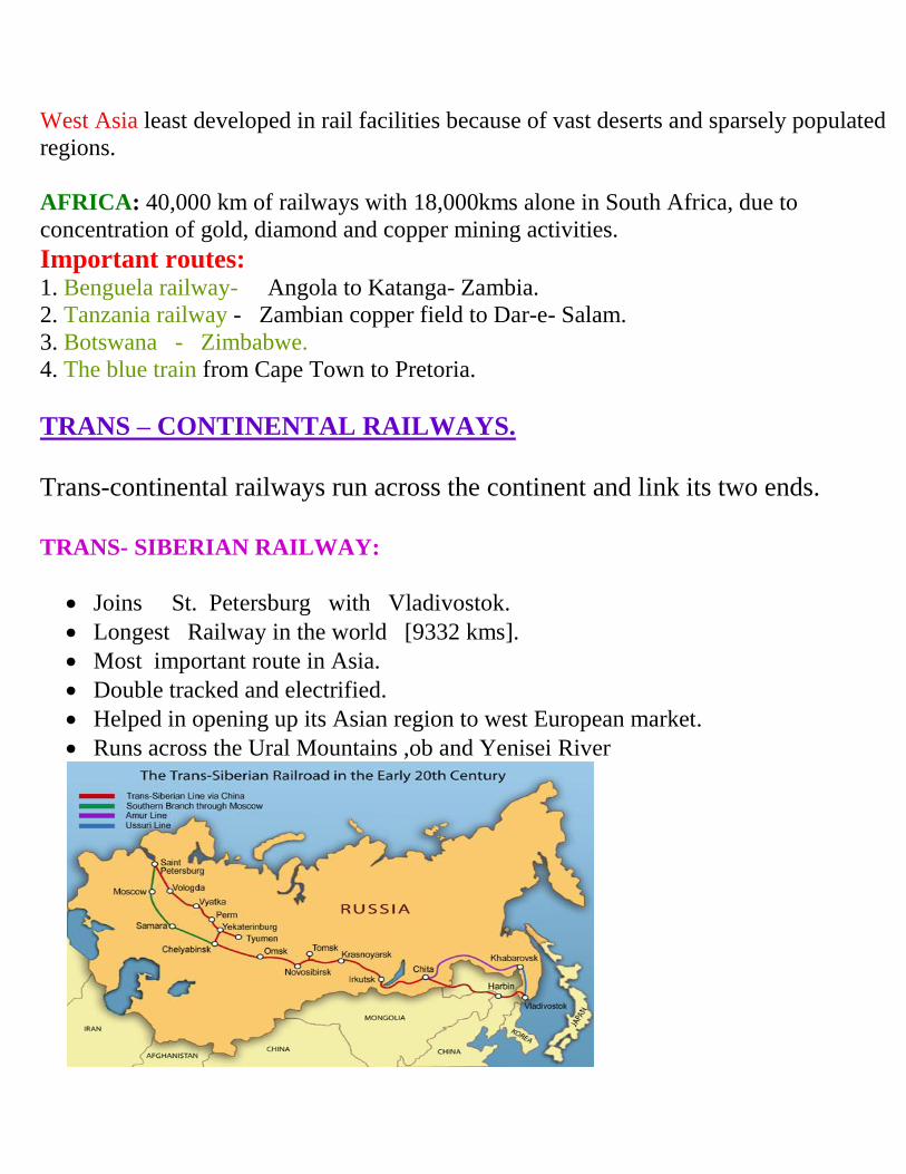
TRANS- SIBERIAN RAILWAY
Joins St Petersburg with Vladivostok
Longest Railway in the world [9332 kms]
Most important route in Asia
Double tracked and electrified
Helped in opening up its Asian region to west European market
Runs across the Ural Mountains ob and Yenisei River
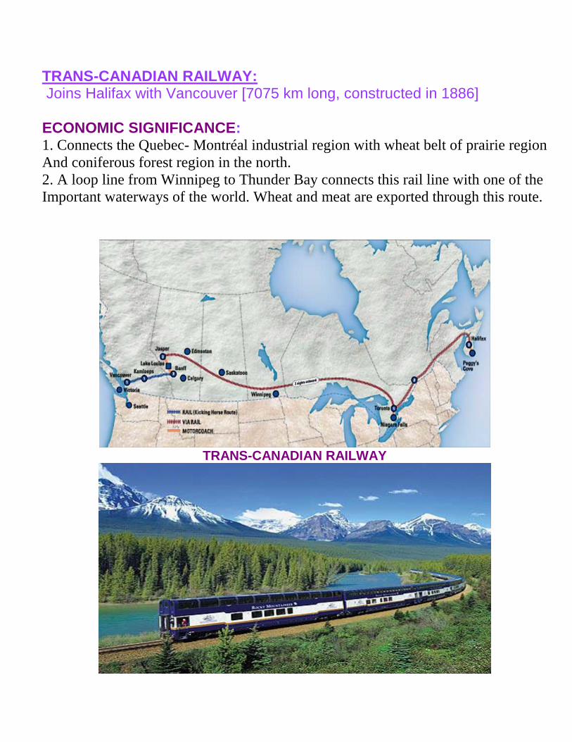
TRANS-CANADIAN RAILWAY Joins Halifax with Vancouver [7075 km long constructed in 1886] ECONOMIC SIGNIFICANCE 1 Connects the Quebec- Montreacuteal industrial region with wheat belt of prairie region
And coniferous forest region in the north
2 A loop line from Winnipeg to Thunder Bay connects this rail line with one of the
Important waterways of the world Wheat and meat are exported through this route
TRANS-CANADIAN RAILWAY
PACIFIC RAILWAY connects New York [Atlantic coast] with San Francisco [pacific
coast]
Valuable exports on this route are oresgrainpaperchemicals
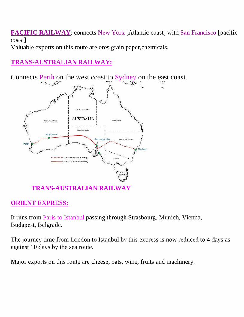
TRANS-AUSTRALIAN RAILWAY
Connects Perth on the west coast to Sydney on the east coast
TRANS-AUSTRALIAN RAILWAY
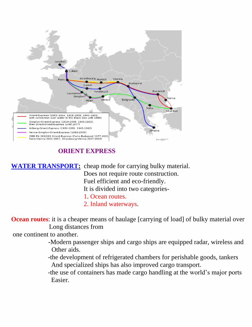
ORIENT EXPRESS
It runs from Paris to Istanbul passing through Strasbourg Munich Vienna
Budapest Belgrade
The journey time from London to Istanbul by this express is now reduced to 4 days as
against 10 days by the sea route
Major exports on this route are cheese oats wine fruits and machinery
ORIENT EXPRESS
WATER TRANSPORT cheap mode for carrying bulky material
Does not require route construction
Fuel efficient and eco-friendly
It is divided into two categories-
1 Ocean routes
2 Inland waterways
Ocean routes it is a cheaper means of haulage [carrying of load] of bulky material over
Long distances from
one continent to another
-Modern passenger ships and cargo ships are equipped radar wireless and
Other aids
-the development of refrigerated chambers for perishable goods tankers
And specialized ships has also improved cargo transport
-the use of containers has made cargo handling at the worldrsquos major ports
Easier
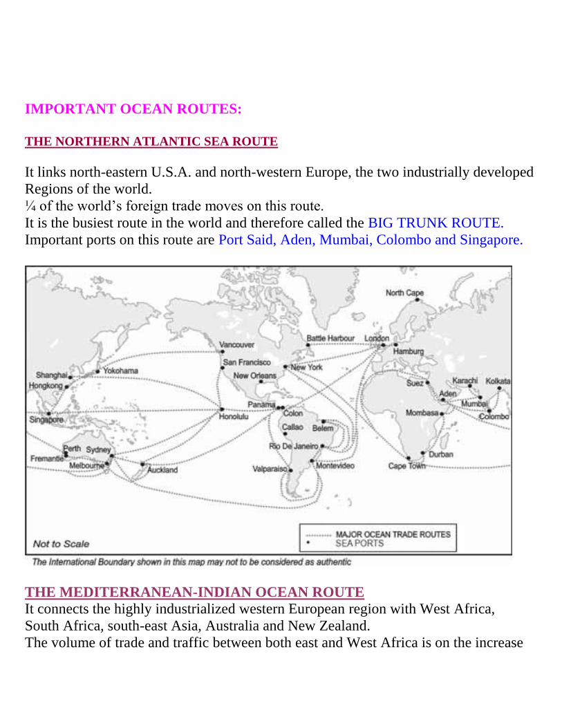
IMPORTANT OCEAN ROUTES
THE NORTHERN ATLANTIC SEA ROUTE
It links north-eastern USA and north-western Europe the two industrially developed
Regions of the world
frac14 of the worldrsquos foreign trade moves on this route
It is the busiest route in the world and therefore called the BIG TRUNK ROUTE
Important ports on this route are Port Said Aden Mumbai Colombo and Singapore
THE MEDITERRANEAN-INDIAN OCEAN ROUTE
It connects the highly industrialized western European region with West Africa
South Africa south-east Asia Australia and New Zealand
The volume of trade and traffic between both east and West Africa is on the increase
Due to the development of the rich natural resources such as golddiamondcoppertin
Groundnut coffee
THE CAPE OF GOOD HOPE SEA ROUTE
Connects west European and West African countries with Brazil Argentina and Uruguay
In South America
The traffic is less on this route due to
- Limited development amp population in SAmerica amp Africa
- Both samerica amp Africa have similar products amp resources
-
NORTH PACIFIC links west coast of NAmerica[VancouverSeattlelos Angeles] with
those of Asia[YokohamaKobeShanghaiHongkongSingapore]
SOUTH PACIFIC It connects Western Europe and NAmerica with Australia
New Zealand and scattered pacific islands via the Panama Canal
Honolulu is an important port on this route
SHIPPING CANALS The Suez and the Panama canals are the two vital man-made
navigation canals
SUEZ CANAL
- It was constructed in 1869 in Egypt between Port Said in the north and port Suez in the
south linking Mediterranean Sea with Red sea
- Gives Europe a new gateway to the Indian Ocean
- 160 kms long and 11-15m deep
- About 100 ships travel daily
- Ship takes 10-12 hours to cross the canal
PANAMA CANAL
It connects Atlantic with pacific
72 km long with 6 lock system
Shortens the distance between New York and San Francisco by 13000 km by sea
Vital to the economies of Latin America
INLAND WATERWAYS rivers canals lakes are important inland waterways
Its development depends on-
1 Navigability [width and depth]
2 Water flow
3 Transport technology
RHINE WATERWAY
Rhine flows through Germany and the Netherlands
Navigable for 700 km from Rotterdam [Netherlands] to Basel [Switzerland]
Dusseldorf is the Rhine port
Worldrsquos most heavily used waterway
Connects industrial area of Switzerland France Belgium and Netherlands with the
NAtlantic sea route
THE GREAT LAKES-STLAWRENCE Lake Superior Huron Erie and Ontario are connected by Soo canal and Welland canal to
form an inland waterway
Duluth and Buffalo are important ports
Large ocean going vessels are able to navigate up the river deep inside the continent to
Montreacuteal
VOLGA
Provides a navigable waterway of 11200km and drains into the Caspian Sea
MISSISSIPPI WATERWAY
Mississippi-Ohio waterway connects the interior part of USA with the Gulf of Mexico
in the south
DANUBE WATERWAY
Important waterway that serves Eastern Europe
River Danube rises in the black forest and flows eastwards towards many countries
AIRWAYS
- Fastest means of transport
- Costly
- Preferred by passenger for long distance travel
- Helpful to reach inaccessible areas
- Valuable cargo can be moved rapidly
Today no place in the world is more than 35 hours away Supersonic aircrafts cover the
distance between London and New York within three and half hours LIMITATIONS
Construction of airports is very expensive
The construction of aircrafts and its operation require elaborate infrastructure like
hangers fuelling and maintenance facilities
INTER-CONTINENTAL AIR ROUTES
Dense network exists in Eastern USA Western Europe and SE Asia
USA alone accounts for 60 of the airways of the world
Newyork London Paris Karachi New Delhi Bankok Singapore Tokyo are some of
the nodal points where air routes converge or radiate to all continents
Africa Asiatic parts of Russia South America lack air services
There is limited air services between 10-35ordm latitude due to-
1 Sparse population 2limited Landmass 3 Economic development
PIPELINES
Used to transport liquids and gases such as water petroleum and natural gas
Cooking gasLPG is supplied through pipelines in many parts of the world
In New Zealand milk is supplied through pipelines from farms to factories
BIG INCH PIPELINE carries petroleum from the oil wells of the Gulf of Mexico to the
north-eastern states
The proposed Iran India via Pakistan international oil and natural gas pipeline will be the
longest in the world 1
According to newspaper reports on 17 June 2011 Iran has given up talks with India on the pipeline
and is pursuing the pipeline bilaterally with Pakistan
In July 2011 Pakistani minister for petroleum and natural resources announced that Iran has finished
its work on laying the pipeline and Pakistan would start the work for building the pipeline within the
next six months[
COMMUNICATIONS
Internet is the largest electronic network on the planet
Communication through satellites emerged as a new area in communication technology
since the 1970rsquos after USA and former USSR pioneered space research
India has also made strides in satellite development
It has made long distance communication television and radio very effective
CYBERSPACE-INTERNET
It is the electronic digital world for communicating or accessing information over
computer networks without physical movement of the sender and the receiver It is also
known as internet
CABLEWAYS GAS PIPE LINE IN ALASKA
IMPORTANT HIGHWAYS Trans-Canadian highway- Vancouver [British Columbia] to st Johnrsquos city [new Foundland] Alaskan highway Edmonton [Canada] to anchorage [Alaska] Pan-american highway a large portion of it has been constructed will connect the Countries of SAmerica central America and usa-canada Trans-continental Stuart highway Darwin to Melbourne Moscow to Vladivostok highway Due to large geographical Areas highways in Russia are not important as railways China in china highways criss-cross the country connecting all major towns and cities like tsungtso Guangzhou and Beijing A new highway links Chengdu with Lhasa in Tibet India national highway no 7 connecting Varanasi with kanyakumari is the Longest in the country Golden quadrilateralsuper expressway connects four metropolitan cities Africa Algiers to Conakry highway and Cairo to Cape Town
TRANS-CANADIAN HIGHWAY [8030 KMS] PAN AMERICAN HIGHWAY [47958 KMS]
NATIONAL HIGHWAY NO7 GOLDEN QUADRILATERAL
Border roads laid along international boundaries
RAILWAYS
The railways gauges vary in different countries and are classified as-
Broad gauge - gt 15 metres
Standard gauge - 144 metres
Metre gauge - 10 metre
Small gauge - lt 10 metre
EUROPE 4 40000 km of railways
Belgium has the highest density of 1km of railway for every 65 sqkms area
Channel tunnel connects London and Paris
RUSSIA ndashrailways accounts for about 90 of the countryrsquos total transport
Dense network west of Urals
Moscow ndashan important rail head
NORTH AMERICA -40 of worldrsquos total railway network
Most dense rail network in east central USA and adjoining Canada
Because this is the most industrialized and urbanized region
AUSTRALIA it has 40000 km of railways of which 25 are found in New South
Wales
SOUTH AMERICA rail network is most dense in two regions
1 Pampas of Argentina
2 Coffee growing regions of Brazil
There is only one trans-continental rail route linking Buenos Aires [Argentina] to
Valparaiso [Chile]
ASIA ndashmost dense rail network in thickly populated parts of Japan India and china
West Asia least developed in rail facilities because of vast deserts and sparsely populated
regions
AFRICA 40000 km of railways with 18000kms alone in South Africa due to
concentration of gold diamond and copper mining activities
Important routes 1 Benguela railway- Angola to Katanga- Zambia
2 Tanzania railway - Zambian copper field to Dar-e- Salam
3 Botswana - Zimbabwe
4 The blue train from Cape Town to Pretoria
TRANS ndash CONTINENTAL RAILWAYS
Trans-continental railways run across the continent and link its two ends
TRANS- SIBERIAN RAILWAY
Joins St Petersburg with Vladivostok
Longest Railway in the world [9332 kms]
Most important route in Asia
Double tracked and electrified
Helped in opening up its Asian region to west European market
Runs across the Ural Mountains ob and Yenisei River
TRANS-CANADIAN RAILWAY Joins Halifax with Vancouver [7075 km long constructed in 1886] ECONOMIC SIGNIFICANCE 1 Connects the Quebec- Montreacuteal industrial region with wheat belt of prairie region
And coniferous forest region in the north
2 A loop line from Winnipeg to Thunder Bay connects this rail line with one of the
Important waterways of the world Wheat and meat are exported through this route
TRANS-CANADIAN RAILWAY
PACIFIC RAILWAY connects New York [Atlantic coast] with San Francisco [pacific
coast]
Valuable exports on this route are oresgrainpaperchemicals
TRANS-AUSTRALIAN RAILWAY
Connects Perth on the west coast to Sydney on the east coast
TRANS-AUSTRALIAN RAILWAY
ORIENT EXPRESS
It runs from Paris to Istanbul passing through Strasbourg Munich Vienna
Budapest Belgrade
The journey time from London to Istanbul by this express is now reduced to 4 days as
against 10 days by the sea route
Major exports on this route are cheese oats wine fruits and machinery
ORIENT EXPRESS
WATER TRANSPORT cheap mode for carrying bulky material
Does not require route construction
Fuel efficient and eco-friendly
It is divided into two categories-
1 Ocean routes
2 Inland waterways
Ocean routes it is a cheaper means of haulage [carrying of load] of bulky material over
Long distances from
one continent to another
-Modern passenger ships and cargo ships are equipped radar wireless and
Other aids
-the development of refrigerated chambers for perishable goods tankers
And specialized ships has also improved cargo transport
-the use of containers has made cargo handling at the worldrsquos major ports
Easier
IMPORTANT OCEAN ROUTES
THE NORTHERN ATLANTIC SEA ROUTE
It links north-eastern USA and north-western Europe the two industrially developed
Regions of the world
frac14 of the worldrsquos foreign trade moves on this route
It is the busiest route in the world and therefore called the BIG TRUNK ROUTE
Important ports on this route are Port Said Aden Mumbai Colombo and Singapore
THE MEDITERRANEAN-INDIAN OCEAN ROUTE
It connects the highly industrialized western European region with West Africa
South Africa south-east Asia Australia and New Zealand
The volume of trade and traffic between both east and West Africa is on the increase
Due to the development of the rich natural resources such as golddiamondcoppertin
Groundnut coffee
THE CAPE OF GOOD HOPE SEA ROUTE
Connects west European and West African countries with Brazil Argentina and Uruguay
In South America
The traffic is less on this route due to
- Limited development amp population in SAmerica amp Africa
- Both samerica amp Africa have similar products amp resources
-
NORTH PACIFIC links west coast of NAmerica[VancouverSeattlelos Angeles] with
those of Asia[YokohamaKobeShanghaiHongkongSingapore]
SOUTH PACIFIC It connects Western Europe and NAmerica with Australia
New Zealand and scattered pacific islands via the Panama Canal
Honolulu is an important port on this route
SHIPPING CANALS The Suez and the Panama canals are the two vital man-made
navigation canals
SUEZ CANAL
- It was constructed in 1869 in Egypt between Port Said in the north and port Suez in the
south linking Mediterranean Sea with Red sea
- Gives Europe a new gateway to the Indian Ocean
- 160 kms long and 11-15m deep
- About 100 ships travel daily
- Ship takes 10-12 hours to cross the canal
PANAMA CANAL
It connects Atlantic with pacific
72 km long with 6 lock system
Shortens the distance between New York and San Francisco by 13000 km by sea
Vital to the economies of Latin America
INLAND WATERWAYS rivers canals lakes are important inland waterways
Its development depends on-
1 Navigability [width and depth]
2 Water flow
3 Transport technology
RHINE WATERWAY
Rhine flows through Germany and the Netherlands
Navigable for 700 km from Rotterdam [Netherlands] to Basel [Switzerland]
Dusseldorf is the Rhine port
Worldrsquos most heavily used waterway
Connects industrial area of Switzerland France Belgium and Netherlands with the
NAtlantic sea route
THE GREAT LAKES-STLAWRENCE Lake Superior Huron Erie and Ontario are connected by Soo canal and Welland canal to
form an inland waterway
Duluth and Buffalo are important ports
Large ocean going vessels are able to navigate up the river deep inside the continent to
Montreacuteal
VOLGA
Provides a navigable waterway of 11200km and drains into the Caspian Sea
MISSISSIPPI WATERWAY
Mississippi-Ohio waterway connects the interior part of USA with the Gulf of Mexico
in the south
DANUBE WATERWAY
Important waterway that serves Eastern Europe
River Danube rises in the black forest and flows eastwards towards many countries
AIRWAYS
- Fastest means of transport
- Costly
- Preferred by passenger for long distance travel
- Helpful to reach inaccessible areas
- Valuable cargo can be moved rapidly
Today no place in the world is more than 35 hours away Supersonic aircrafts cover the
distance between London and New York within three and half hours LIMITATIONS
Construction of airports is very expensive
The construction of aircrafts and its operation require elaborate infrastructure like
hangers fuelling and maintenance facilities
INTER-CONTINENTAL AIR ROUTES
Dense network exists in Eastern USA Western Europe and SE Asia
USA alone accounts for 60 of the airways of the world
Newyork London Paris Karachi New Delhi Bankok Singapore Tokyo are some of
the nodal points where air routes converge or radiate to all continents
Africa Asiatic parts of Russia South America lack air services
There is limited air services between 10-35ordm latitude due to-
1 Sparse population 2limited Landmass 3 Economic development
PIPELINES
Used to transport liquids and gases such as water petroleum and natural gas
Cooking gasLPG is supplied through pipelines in many parts of the world
In New Zealand milk is supplied through pipelines from farms to factories
BIG INCH PIPELINE carries petroleum from the oil wells of the Gulf of Mexico to the
north-eastern states
The proposed Iran India via Pakistan international oil and natural gas pipeline will be the
longest in the world 1
According to newspaper reports on 17 June 2011 Iran has given up talks with India on the pipeline
and is pursuing the pipeline bilaterally with Pakistan
In July 2011 Pakistani minister for petroleum and natural resources announced that Iran has finished
its work on laying the pipeline and Pakistan would start the work for building the pipeline within the
next six months[
COMMUNICATIONS
Internet is the largest electronic network on the planet
Communication through satellites emerged as a new area in communication technology
since the 1970rsquos after USA and former USSR pioneered space research
India has also made strides in satellite development
It has made long distance communication television and radio very effective
CYBERSPACE-INTERNET
It is the electronic digital world for communicating or accessing information over
computer networks without physical movement of the sender and the receiver It is also
known as internet
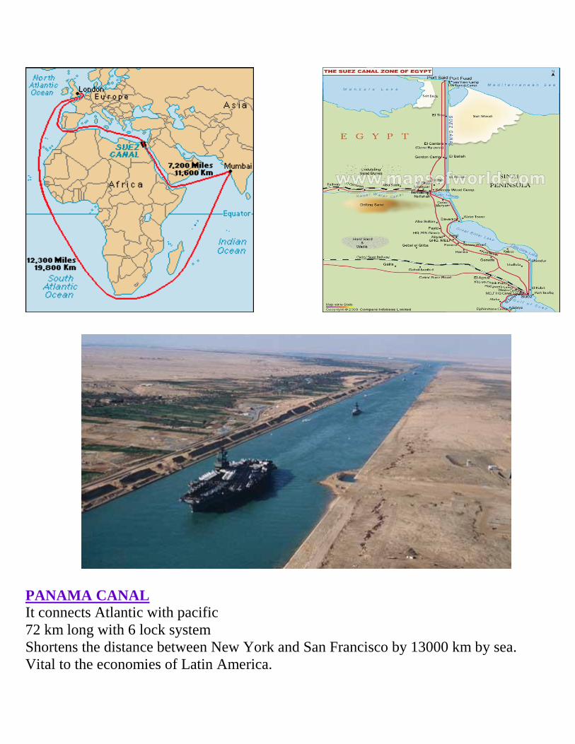
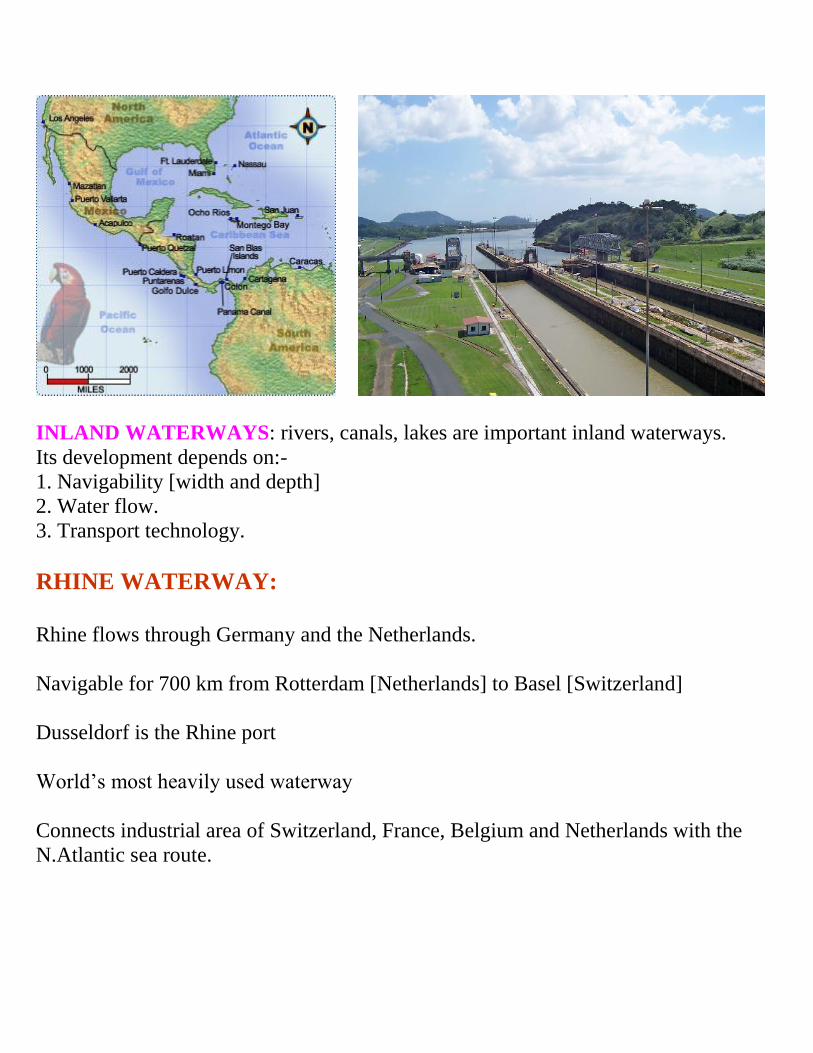
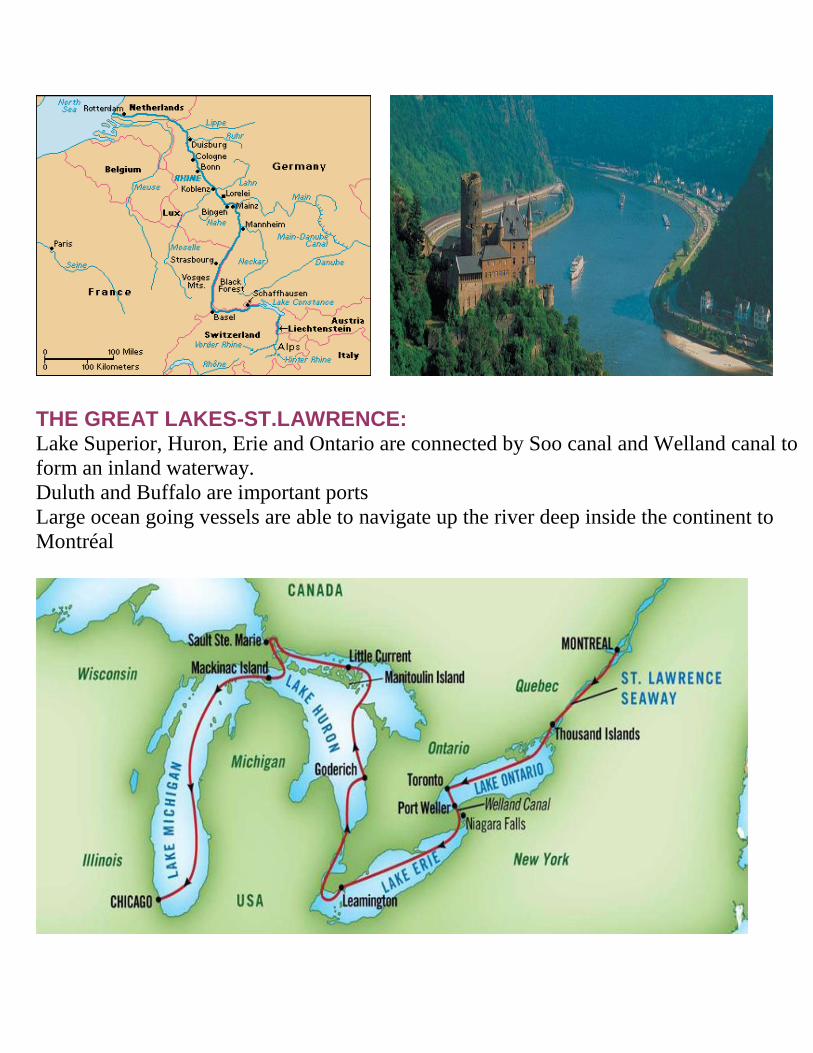
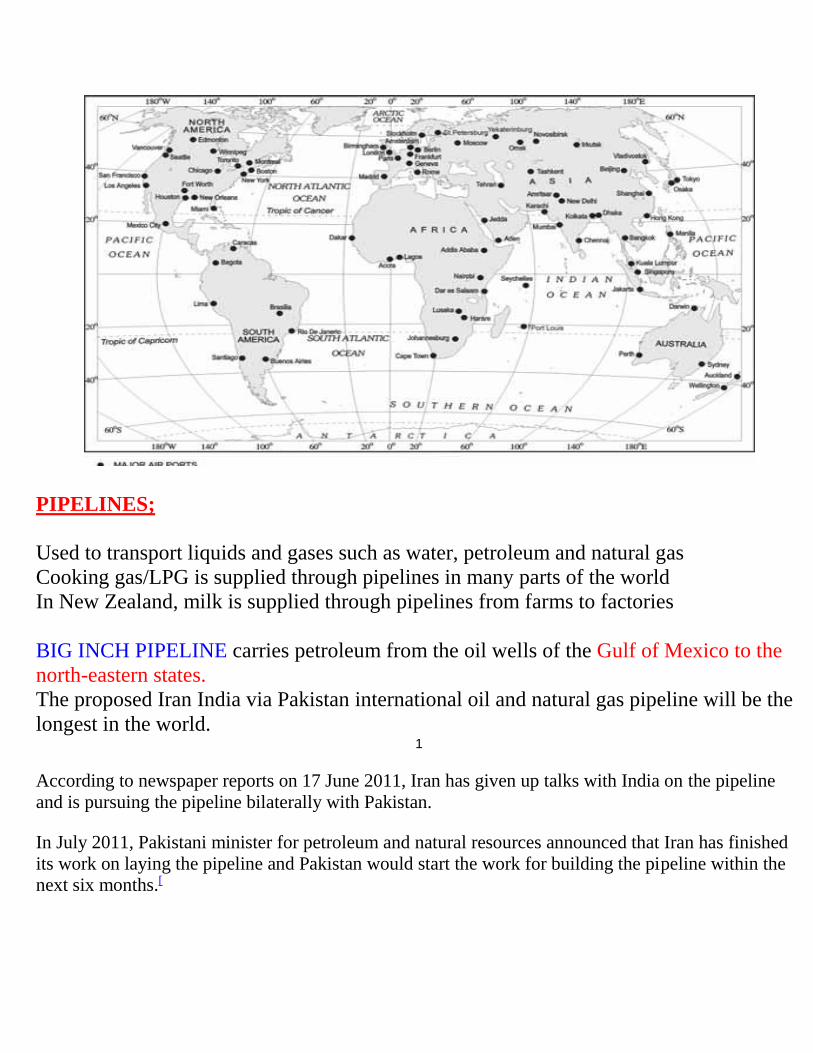