Embed Size (px)
Citation preview
Modeling the location of natural cold-limited treeline and alpine meadow
habitats in the Ukrainian Carpathians
Alexander Mkrtchian1, Daria Svidzinska2
1Ivan Franko National University of Lviv 2Taras Shevchenko National University of Kyiv
Forum Carpaticum 2014: Local Responses to Global Challenges September 16-18, 2014, Lviv, Ukraine

The upper timberline — the upper elevational limit of forest and tree growth and survival on high mountains due to environmental constrains (usually an ecotone) (Wieser, Tausz, 2007)
The forest line — the upper limit of a continuous forest canopy (Wieser, Tausz, 2007) The tree limit — the upper limit of trees, krummholz, and shrubs higher than 2 m (Wardle 1974, Ellenberg 1996, Wieser, Tausz, 2007)

Problem formulation
• Alpine meadow biotopes contain unique and
valuable habitats
• An alpine zone in the Ukrainian Carpathians is rather small and mostly consists of rather small and isolated patches
• Global warming will shift altitudinal belts upwards, shrinking the alpine meadow biotopes
• The amount of prospective loss of alpine meadow
biotopes is unknown and merits further researches
The study goals
• To reveal and determine the extent of the alpine
biotopes and alpine meadow ecosystems in Ukrainian Carpathians
• To make predictions about their spatial changes for the middle of the present century
Seminal works on the treelines and their environmental drivers • Humboldt Al. de, Bonpland A., 1816. Voyage aux régions équinoxiales du
Nouveau Continent. Libr. grecque, latine, allemande, Paris, France, pp. 1–420
• Däniker, A., 1923. Biologische Studien über Wald- und Baumgrenze, insbosondere über die klimatischen Ursachen und deren Zusammenhänge. Vierteljahrsschr. Nat. forsch. Ges. Zür. 68: 1–102
• Tranquillini W., 1979. Physiological ecology of the alpine timberline: tree existence at high altitude with special reference to the European Alps. In: Ecological Studies. Springer-Verlag, Berlin, Germany, pp. 1–137
• Wieser G., Tausz M., 2007. Trees at their Upper Limit: Treelife limitation at the alpine timberline. Springer, NJ, USA, pp. 1–232
• Holtmeier F.-K., 2009. Mountain Timberlines. Springer, NJ, USA, pp. 1–437
• Körner C., Riedl S., 2012. Alpine Treelines. Springer, Basel, Switzerland pp. 1–220
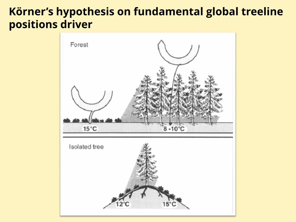
Körner’s hypothesis on fundamental global treeline positions driver
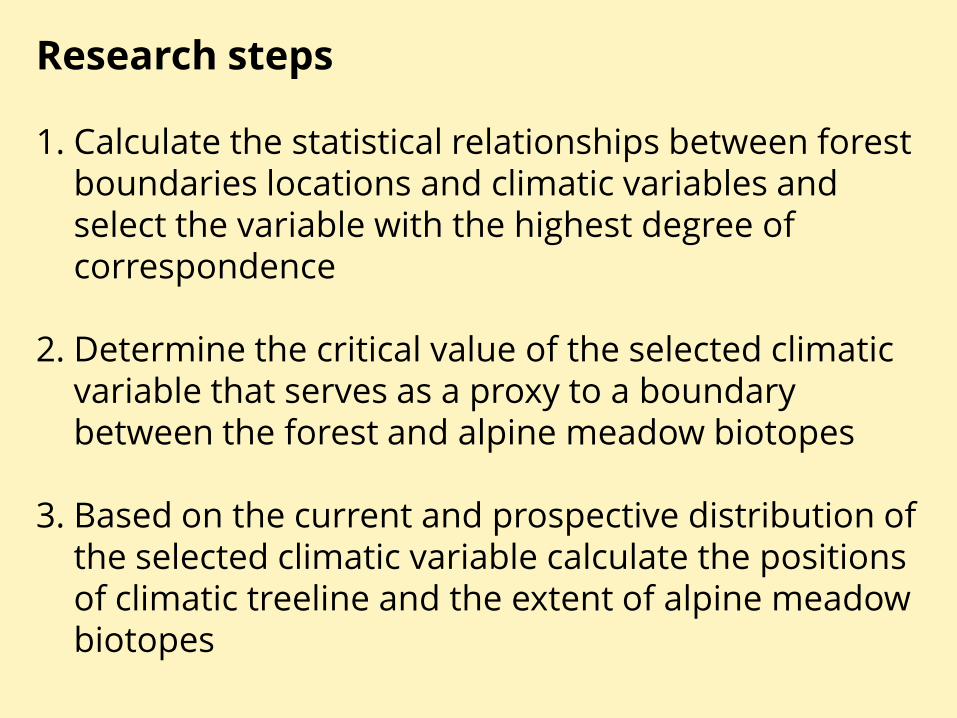
Research steps
1. Calculate the statistical relationships between forest boundaries locations and climatic variables and select the variable with the highest degree of correspondence
2. Determine the critical value of the selected climatic variable that serves as a proxy to a boundary between the forest and alpine meadow biotopes
3. Based on the current and prospective distribution of the selected climatic variable calculate the positions of climatic treeline and the extent of alpine meadow biotopes

Data used
• SRTM 90m Digital Elevation Data v4.1
• Landsat 5 TM imagery
• WorldClim dataset
o current climatic data (1960 – 2000)
o projections of global climate model (GCM) data from CMIP5 (IPPC 5th Assessment)
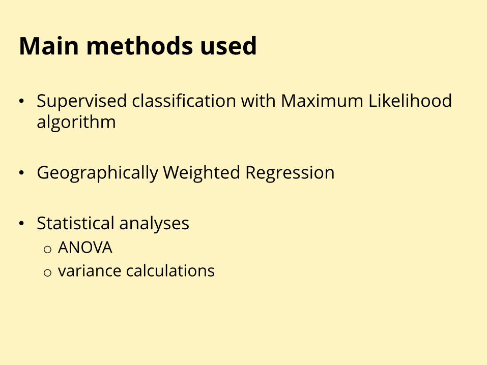
Main methods used
• Supervised classification with Maximum Likelihood algorithm
• Geographically Weighted Regression
• Statistical analyses
o ANOVA
o variance calculations
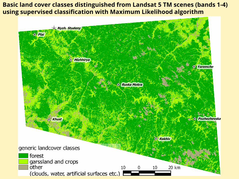
Basic land cover classes distinguished from Landsat 5 TM scenes (bands 1-4) using supervised classification with Maximum Likelihood algorithm
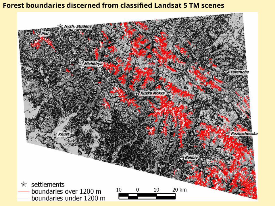
Forest boundaries discerned from classified Landsat 5 TM scenes
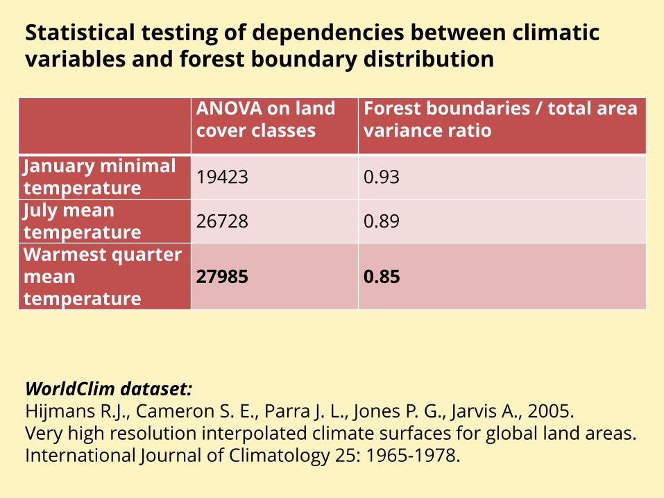
ANOVA on land cover classes
Forest boundaries / total area variance ratio
January minimal temperature
19423 0.93
July mean temperature
26728 0.89
Warmest quarter mean temperature
27985 0.85
Statistical testing of dependencies between climatic variables and forest boundary distribution
WorldClim dataset: Hijmans R.J., Cameron S. E., Parra J. L., Jones P. G., Jarvis A., 2005. Very high resolution interpolated climate surfaces for global land areas. International Journal of Climatology 25: 1965-1978.

Histograms of the distribution of warmest quarter mean temperature values for total area above 1200 m a.s.l. and for areas corresponding to forest boundaries
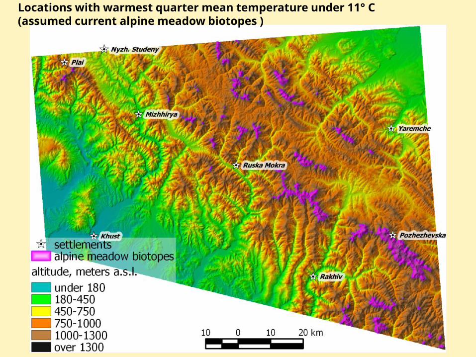
Locations with warmest quarter mean temperature under 11° C (assumed current alpine meadow biotopes )
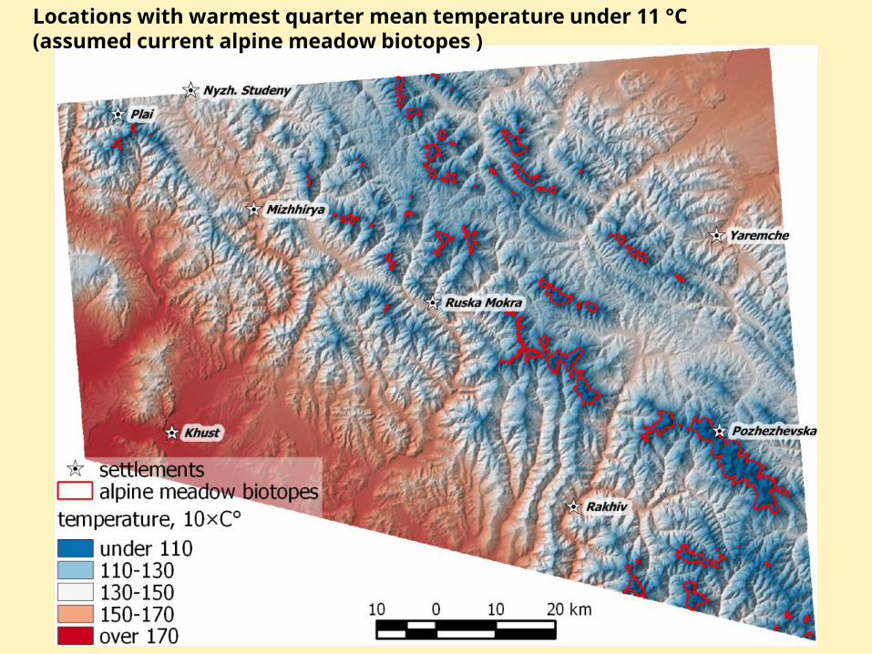
Locations with warmest quarter mean temperature under 11 °C (assumed current alpine meadow biotopes )
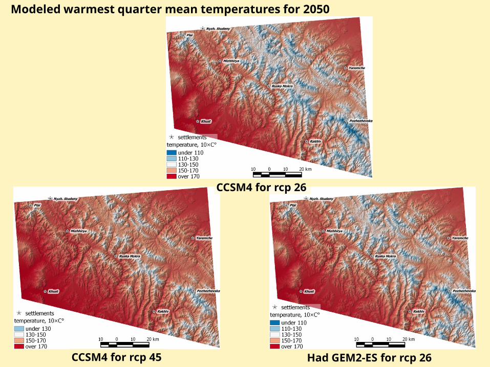
Modeled warmest quarter mean temperatures for 2050
CCSM4 for rcp 26
CCSM4 for rcp 45 Had GEM2-ES for rcp 26

Assumed changes in sizes and boundaries of alpine meadow biotopes, based on CCSM4
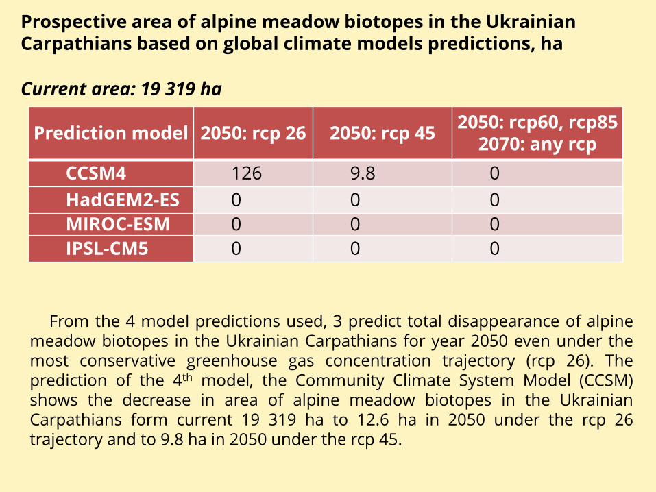
Prediction model 2050: rcp 26 2050: rcp 45 2050: rcp60, rcp85
2070: any rcp
CCSM4 126 9.8 0
HadGEM2-ES 0 0 0
MIROC-ESM 0 0 0
IPSL-CM5 0 0 0
Prospective area of alpine meadow biotopes in the Ukrainian Carpathians based on global climate models predictions, ha
From the 4 model predictions used, 3 predict total disappearance of alpine meadow biotopes in the Ukrainian Carpathians for year 2050 even under the most conservative greenhouse gas concentration trajectory (rcp 26). The prediction of the 4th model, the Community Climate System Model (CCSM) shows the decrease in area of alpine meadow biotopes in the Ukrainian Carpathians form current 19 319 ha to 12.6 ha in 2050 under the rcp 26 trajectory and to 9.8 ha in 2050 under the rcp 45.
Current area: 19 319 ha