Embed Size (px)
DESCRIPTION
Presentation by Yao-Min (Frank) Fang during the Sensor Web System and Visualization paper session of the Sensor Web Enablement workshop (held during the 2011 Cybera Summit).
Citation preview

Yao-Min (Frank) FangGeographic Information Systems Research Center Feng Chia UniversityTaiwan
www.gis.tw
Sensor Web Enablement for Debris Flow Monitoring System in Taiwan
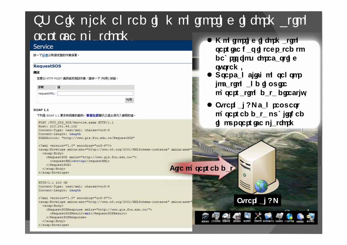
OGC ComplianceTesting Center

Monitoring Stations
Debris Flow Monitoring Station×18Landslide Monitoring Station×3Sediment Concentration Monitoring Station×4Mobile Debris Flow Monitoring Station ×3Portable Unit ×14
2
01.白布帆站 (Baibufan Station)02.九份二山站 (Jiufen-Ershan Station)03.神木站 (Shenmu Station)04.上安站 (Shang-an Station)05.郡坑站 (Jyunkeng Station)06.豐丘站 (Fongciou Station)07.大粗坑站 (Dacukeng Station)08.鳳義坑站 (Fongyikeng Station)09.射馬干站 (Shemangan Station)10.華山站 (Huashan Station)11.大興站 (Dasing Station)12.豐山站 (Fongshan Station)13.松鶴站 (Songhe Station)14.坪頂站 (PingDing Station)15.蘇樂站 (Suru Station)16.玉峰站 (Yufong Station)17下田埔站 (Shiatainpu Station)18.羌黃坑站 (Cianghuangkeng Station)19.集來站 (Jilai Station)20.來義站 (Laiyi Station)21.大鳥站 (Daniao Station)22.南豐站 (Nanfeng Station)

wire sensors
ultrasonic water level Transmitter
Geophonerain gauge
CCD camera and infrared spotlight
Sensors of Permanent monitoring station

Permanent Debris Flow Monitoring Station– Jioufen-ershan

Temperature and humidity sensor
Solar irradiation sensor
Wind speeds and directions sensor
Atmospheric pressure sensor
Soil water content sensor
Geophone
Wire Sensor
CCD CameraWater Level Meter
Sensors in Debris Flow Monitoring Station
Meteorologicalsensors

Debris Flow Monitoring Information System – Shenmu Station

Current Debris Flow Monitoring SystemReal –time data is transmitted
to ERC at SWCB by advanced communication technology, such as satellite, 3.5G, and Internet.
CCD
Meteorological Instrument
Wire Sensor
GeophoneRain Gauge
Water Content
On-Site Station
Emergency Response Center
Power Supply
Online Notice
Risk Mgmt.
Cell phones
3.5G
Mobile Station
Radar Water Level Gauge

Typhoon MORAKOTShen-Mu Debris Flow Monitoring Station

The Debris Flow Event of AiyuziRiver (8/8 16:57)
Aiyuzi River CCD image (front) Aiyuzi River CCD image (side)

The comparison of UAV images before and after the debris flow event at upstream

0
10
20
30
40
50
60
70
80
90
2009/8/6 09:00
2009/8/6 13:00
2009/8/6 17:00
2009/8/6 21:00
2009/8/7 01:00
2009/8/7 05:00
2009/8/7 09:00
2009/8/7 13:00
2009/8/7 17:00
2009/8/7 21:00
2009/8/8 01:00
2009/8/8 05:00
2009/8/8 09:00
2009/8/8 13:00
2009/8/8 17:00
2009/8/8 21:00
2009/8/9 01:00
2009/8/9 05:00
2009/8/9 09:00
2009/8/9 13:00
2009/8/9 17:00
2009/8/9 21:00
2009/8/10 01:00
2009/8/10 05:00
2009/8/10 09:00
2009/8/10 13:00
2009/8/10 17:00
2009/8/10 21:00
2009/8/11 01:00
2009/8/11 05:00
2009/8/11 09:00
2009/8/11 13:00
2009/8/11 17:00
2009/8/11 21:00
時間
時雨量(mm)
0
200
400
600
800
1000
1200
1400
1600
1800
累積雨量(mm)
神木時雨量 神木累積雨量
Aiyuzi River Debris Flow Event2009/08/08 04:35 2009/08/08 04:39
Wire 1 broke 8/8 4:11
Wire 2 broke8/8 04:39
2009/08/08 04:41
Aiyuzi River wire broke
Accumulate rainfall:1500mm
The heaviest rainfall :82mm/per hour

Estimating of debris flow velocity
The comparison of downstream and midstream Underground Sound analysis by Wavelet Transform at Shen-Mu station
(8/8 4:36~4:42)
10 seconds
50m
50m/3sec=17m/s
173m/10sec=17m/s

Mobile Debris Flow Monitoring Station

The 4th Generation Mobile Station

4thS Mobile monitoring station

Challenges on Extreme Weather Condition after Typhoon Morakot

Compound hazards occurredat Xiao-lin Village, Jia-xien, Kaoshiung: Flooding Shallow landslide Debris flow Deep landslide Barrier dam Dam bursting
甲仙鄉小林村災害
(複合型災害)
2008/11Pre-typhoon
2009/8Post-Morakot
Compound Hazards occurred simultaneously:

Time
Long-term Monitoring On-Site Station
On call for hazard alert and response
Mobile Station
Portable Units
Transmitting to ERC
Hazard Alert & Response
Upp
er S
trea
mM
idst
ream
Dow
n St
ream
Basin-Wide Monitoring Network

Portable Unit
UAV
PointLinePlane: extended to upper stream and the source of debris, considering a wholewatershed.
Combining on-site, mobile station, and portable units.
Integrating data from different agencies.
On-Site Station
Mobile Station
Basin-Wide Monitoring Network
自動溫濕度計
日照輻射計
風力風向計
大氣壓力計
土壤含水量
地聲
鋼索
CCD
水位計
土石流觀測站先進量測儀器

Portable Unit

Plug-and-PlayPower Supply
Flexible onInstrumentInstallation
Portable Unit R&D
Easy to Operate
VariousCommunicationOptions
OGC‐SWE StandardEasy to
TransportBasic monitoring functions
Lightweight
Design Conception
21
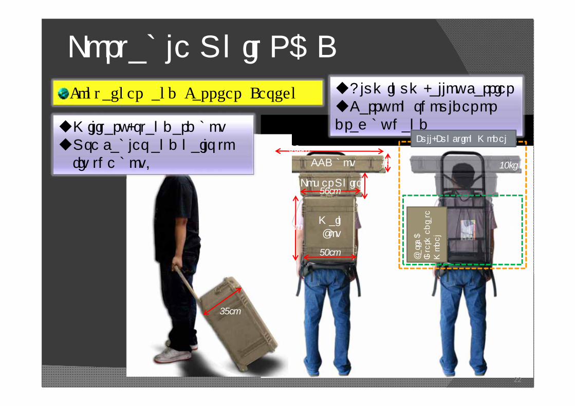
Portable Unit R&DContainer and Carrier Design Aluminum-alloy carrier
Carry on shoulder or drag by hand
22
50cm
63cm
CCD box
Power Units
MainBox
35cm
96cm
56cm23cm
16cm
20kg
10kg
Full-Function Model
35kg
Basic &
Intermediate
Model
Military-standard boxUse cables and nails to fix the box.

Portable Unit R&D
Touch ScreenControl interface
Rain gauge
Data TransmitterPower
Units
Data Processing UnitsSoil
water moisture
Geophone
23

Rain gauge Soil moisture meter
Geophone
CCD Camera
Receiver
AD Converter Wild Box Module
Storage
Computing
Communication
Receiving
Portable Unit
SOS
SAS
SPS
Portable Unit1
Portable Unit2
Portable Unit3
NCDR
WRA
MOTC
CWBSWCBCWB WRA
SWCB
GetObservation()

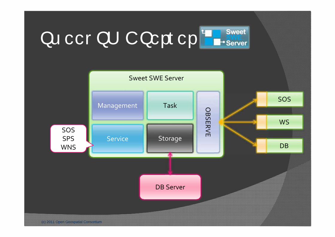
Sweet SWE Server
2011 Geoinformatics Interoperability Days
Sweet SWE Server
Sensor
Sensor
Sensor
Application
(c) 2011 Open Geospatial Consortium
Sweet SWE Server
Sweet SWE Server
DB Server
OBSERV
E
SOS
WS
DBStorage
TaskManagement
ServiceSOSSPSWNS
Portable Units

Landslide Monitoring
Landslide
Building

Landslide Monitoring
Landslide

Landslide Monitoring
Carry on portable unitSetup Mobile Station
securityCarry down to top of
the landslide

Landslide Monitoring
Setup portable unit
Working

Landslide monitoring system
Window

SWE implemented in our monitoring information service platform
Monitoring information service has integrated to debris flow forecasting system.
http://monitor.swcb.gov.tw
SWE implemented in monitoring information service platform Monitoring information
service has integrated to debris flow forecasting system.
User can click on sensor location and inquire observation data directly.
http://monitor.swcb.gov.tw
SWE implemented in monitoring information service platform Monitoring information
service has integrated to debris flow forecasting system.
User can click on sensor location and inquire observation data directly.
External AP can request observed data published in our service platform
External AP
Cite observed data

Conclusions Use 3S technique and a complete monitoring and
management system to provide complex type of hazards’ real-time data.
Integrate information and data from agencies by OGC’s SWE standard.
The portable unit includes PAC, battery, communication, CCD camera, geophone, handy rain gauge, soil moisture sensor and Sweet Swe Server.
The portable unit had been approved a success on monitoring landslide and providing SWE-standard data to different agencies.

Thanks for your attention