Embed Size (px)
Citation preview

Approach, Methodology, Vision, Structure, Strengths and Services
CREATIVE CIRCLE, NAGPUR
1
,

COMPANY BRIEF
d b h h bh
Our firm offers
City PlanningIncepted by Mrs. Manjusha Sahasrabhojanee “Creative Circle” was born out of the parental firm established in 1964 by Bhaskar D. Sahasrabhojanee, graduated at Nagpur and
d d d b ikhil S h bh j
City Planning,
Architectural Consultancy,
Engineering Consultancy,
U b D i d U b R d lLondon. Headed by Nikhil B Sahasrabhojanee and Manjusha N. Sahasrabhojanee, Registered with the Council of Architecture, New Delhi, as per Architects’ Act of 1972 and
b f I i f T Pl I di
Urban Design and Urban Redevelopment Planning,
Heritage, Environmental & Social Reform Planning,
member of Institute of Town Planners, IndiaHousing and Slum Rehabilitation Planning,
Green and Solar City Planning,Our Offices:Head Office
Special Area and Industrial Planning,
Interior Design & Decoration,
Landscape Consultancy,
• II FL., 31, Bhaskar Prabha, East Shankar Nagar, Nagpur‐440010, Maharashtra
Branch Offices•New Delhi : # 8004, D‐8, Vasant Kunj, New Delhi‐70,
•Gurgaon : # flat no 98, H.E.W.O. Apartments, Sector 31, Gurgaon – 122001, HaryanaBh l # E 7/713 A l Bh l 462017 M P
Sewerage, Sanitation and Solid Waste Management Consultancy,
Road Development & Street Design
•Bhopal : # E‐7/713, Arera colony, Bhopal – 462017, M P.•Bhubaneswar : Socrates, D‐2/7, Industrial Estate, Rasulgarh, Bhubaneswar‐751010, Orissa.•Kochi : # 1st Floor, M M Buildings, Kalabhavan Road, Kochi‐682018, KeralaContact Offices: KOLKATA, KARNATAKA, DHULIJAN (ASSAM), RANCHI
Market Feasibility Study, PPP Project Planning,
GIS and MIS Planning
Contact Us Website : creativecindia.comE‐mail : [email protected]
:[email protected] No. : + 91 712 2523520, +91712 5250977
2
Valuation and allied servicesFax : + 91 712 2523520. Mobile : 09422109676 / 09423073291

Services offered from concept to commissioningCITY PLANNING THEMATIC DEVELOPMENTCITY PLANNING, THEMATIC DEVELOPMENTARCHITECTURAL CONSULTANCY, ESPECIAL BUILDINGS PLANNINGURBAN DESIGN, HERITAGE, ENVIRONMENTAL & SOCIAL REFORM PLANNING,SOCIAL HOUSING, HIGH PROFILE HOUSING AND TOWNSHIP DESIGNS,TOURISM AND ECO-TOURISMS PROJECT PLANNINGINTERIOR DESIGN & DECORATIONINTERIOR DESIGN & DECORATION,LANDSCAPE CONSULTANCY,SANITATION AND SOLID WASTE MANAGEMENT CONSULTANCY,ROAD DEVELOPMENT & STREET DESIGNMARKET FEASIBILITY STUDY,VALUATION and allied services.
OUR REACH
We have a team of well‐qualified and experienced technical personals capable of providing consultancy in
MANY STATES OF INDIA
MAHARSHTRA CHHATTISGARH MADHYA PRADESH UTTRANCHAL
JHARKHAND BIHAR ASSAM ODISHA ANDHRA PRADESH HARYANA
Potential
KERALA KARNATAKA GUJARAT WEST BENGAL RAJASTHAN NE STATES
evaluation with
constraintsConcept
Technical &FinancialAppraisal
Funding Options and
feasibility
Implementation/Monitoring &Supervision
Vision/theme formulation
3CREATIVE CIRCLE, NAGPUR

Our Vision
Vision
Creating thematic development and new vision for region throughdevelopment plans; tourism planning, Ecotourism planning, area planning;urban design; infrastructure projects, benchmarking against international &national standards ensuring induction of best practices and efficienciesnational standards, ensuring induction of best practices and efficienciestowards implementation, stressing sustainability and use of non-conventional energy resources
Approach
Creation of a Perspective development Plan of theopportunities:
Assessment for hidden potential of the Project area/region and thep j gCitizens/users.
Involvement of Citizens in formulation, implementation and benefit of visionand development of the City/region/project areaEnhancing collaboration of Federal and Local Government and its AgenciesEnhancing collaboration of Federal and Local Government and its Agenciesto address infrastructure needs in sustainable format.Introducing rigorous project development to successfully commercializeprivate sector led projectsInducing use of non-conventional energy resources for less dependency onconventional energyAssisting in obtaining funds during project development and implementation
4CREATIVE CIRCLE, NAGPUR

P t
MethodologyAssessment Of Study Area
Opportunities, Strengths, Risks and Weaknesses
Unmet Demand/ Gap
Parameters
Demography Economic Base Financial Physical & Environmental Infrastructure
Stages of CDP preparation• reconnaissance survey• Situation analysis
Unmet Demand/ GapOther requirements Institutional Set Up
Regional SettingDevelopment area’sPotentialsGovernment Schemes for development
d
• Tourism sector analysis• Stake holders meeting• Engineering study
T i t d i ll for development (Central / State)Future Perspective and
Designing/ Planning
Direction of DevelopmentProposals
S t / C t
Consultations with appropriate Authorities to understand the situation
• Tourism study in alltype of tourism
• Heritage conservation• Archeological
Strategies and Development
Sectors/ Components
Environmental Settings
•Tourism
situationg
conservation• Formulation of vision• Identification of
potential sitesOptions and Strategies for Development of Region
Development
•Regional Settings
•Financial Aspects/ Estimates
potential sites• Infrastructure planning• Tourism strategies• FOP planning Estimates
•Connectivity
•Services to tourist
•Rehabilitation etcInvestment & Options for
• Finalisation of DTPthro’ consultations
5
•Rehabilitation etc.Development

COMPOSITION OF THE TEAM
• The team of international and local experts selected for the project has been chosen with a strong emphasis on experience and the proven ability to generate innovative, efficient and effective solutions to the problems that may arise duringinnovative, efficient and effective solutions to the problems that may arise during project implementation.
• The team brings:• International experience• Experience in urban planning sectors • Experience in urban infrastructure sectors
l• Experience in GIS implementation• Experience in PPP implementation• Experience in urban designing and legislation
E ll t t h i l d l ti l kill i l t t thi j t• Excellent technical and analytical skill in areas relevant to this project• Ability to work closely with the client at all stages of a project.
• The team is consisting of the experts as mentioned in TOR plus urban planners, social expert and engineers to work on a holistic approach towards a sustainable development project

Team For Development Plan Preparation
Form 5: Details of staff with firm: Expert team for the project S.No Family Name, First Name Details of staff Qualifications Experience 1 Sahasrabhojanee Nikhil Team Leader (1 No) MASTER IN PLANNING, 1991,SPA,NDEL 25 YRS 6 MONTHS2 Sahasrabhojanee M.N. TEAM LEADER 2 B.Arch. MASTER IN PLANNING, 1991,SPA,NDEL 27YRS 6MONTHS3 Pradumn3 Pradumn
Sahasrabhojanee Sr. Architects B.Arch. Master of urban design 1989,SPA,NDEL 29yrs 6 months
4 Bhushan Chambewar Junior Planner B.Arch. master of planning2007( Industrial) 8 yrs
5 Anand Prakash Structures
BE (Civil), University of Roorkee, 1969; L.L.B, Lucknow University 1992
44 YRSUniversity, 1992
6 Abhay Kumar KhareTraffic Engineer
M.E. (Planning, with Spl. In Transport Planning), Delhi University, 1993‐94; B.E.(Civil), Nagpur University, 1988
19 yrs
7 Kishore Pampatwar Infrastructure Engineer
B.E. Civil 27 Years
8 D R h l V R l k P i Ph D (P i S l A hit t ) BITS Pil i 2005 M E 138 Dr. Rahul V. Ralegaonkar Passive energy Engineers
Ph. D. (Passive Solar Architecture), BITS, Pilani, 2005, M.E. (Civil), BITS, Pilani, 2000, B.E. (Civil), Nagpur University, 1998
13 yrs
9 Sahasrabhojanee Atul Charted Accountant Legal & institutional
B.Com. (Hon.), Chartered Accountant in Nov., 1985 25
institutional Expert
10 Chopalli Shrinagesh Municipal finance & PPP expert
B. Com from Revensha College, Cuttack,’82; C.A. Institute of Chartered Accountants of India,’87.
32
11 Dr. Anuj Gahlot GIS & remote i E t
2007, C.C.S. University Meerut, Ph.D in Geography; 2002, MM H C ll Gh i b d M A G h 2000
06sensing Expert M.M.H. College Ghaziabad, M. A. Geography; 2000,
M.M.H. College Ghaziabad, B.A.12 Rajini Saini GIS & remote
sensing Expert 2010 Master of Science, in Geo‐informatics from Sikkim Manipal University; 2007 B.A Hons. Geography from Bhim Rao Ambedkar College, Delhi University
03
13 Santosh Kumar Saxena Revenue Expert M Sc (Maths) in 1974 M P Public Service Commission 28yrs
7
13 Santosh Kumar Saxena Revenue Expert and land acquisitions
M.Sc.(Maths) in 1974, M.P Public Service Commission 1987
28yrs

Experience
Development /Structure plan of new Kabul City : DEHSABZ NORTH AREA UNDER PHASE II PROGRAM
International Experience
Cit D l t Pl 9 23City Development Plan 9+23Integrated master plan 1District master plans 9District vision plan 2District vision plan 2Sector/ Area planning 3Island master plan 2
8

S t l E iSectoral Experience Some Project Examples of sactorial
spread
Sectors:
• Urban design & Architecture• Tourism Planning• Heritage tourism planning• District Perspective Plan • City Development Plan• Urban Infra and Municipal Services• Social Housing • Rural development• Environmental projects
9CREATIVE CIRCLE, NAGPUR

PROJECT DATA SHEETS
CREATIVE CIRCLE, NAGPUR
10
,

Structure plan of new Kabul City : DEHSABZ NORTH AREA UNDER PHASE II PROGRAM Afghanistan
I i ti ith SPAGEO DELHIKABUL NEW CITY is about 740 square kilometer
which is made of four broad areas, Dehsabz South, Dehsabz North, Paymonard B ik b Th j
In association with SPAGEO, DELHI
and Barikab. The project area was Dehsabz North : total land area of 21322hectare ( 1 hectare=10000 sq m ) 30 lakhspopulation. A conceptual structure of land use and road network has been proposed by the KNC master plan for Dehsabz North area at the scale of 1:50000.
The work undertaken were : Developed a comprehensive structure plan for DehsabzNorth area; Develop strategy forNorth area; Develop strategy for development of Dehsabz North under phase II program; Conform the strategic frameworks of the Master Plan by detailing it in the structure plan; Study the impact of structure plan on KNC master plan; and Examine the land use allocation with respect to their functions and accessibility.
Survey of area was done extensively to collect ground realities to match detailed out theground realities to match, detailed out the Master Plan components, suggestion for thematic vision in addition to the Master plan guidelines to incorporate new technology and green architecture d l t Utili d th fdevelopment , Utilized the references provided by the DCDA for preparation of structure plan;
11

Structure plan of new Kabul City : DEHSABZ NORTH AREA UNDER PHASE II PROGRAM Afghanistan
Review the KNC master plan development specific toDehsabz North area; The structure plan incorporated anintegrated spatial function, accessibility, mobility andsustainability; Delineate the area into hierarchical zones
fg
sustainability; Delineate the area into hierarchical zonesand development of public facilities for the requirementsof Dehsabz North area population; Assessment of thetransportation demand was done utilizing the existingtransportation master plan and other sources as necessary;Infrastructure facilities were planned based on master planp pconcepts and also new concepts were proposed; strategiesand demand calculation for various sectors, stress onincrease of green percentage and development of all parksand water bodies, detailed analysis of project for watersupply, sewerage, road network, transport means, electricpower consumption, etc.
12

PATTERN OF DEVELOPMENT•Project phasing
1 Water Supply/ Wind Energy to be developed
Lake
S l i
1.Water Supply/ Wind Energy to be developed.2.Development near 26th Dalwa to be taken up (within the blue line as shown in Master Plan)3.Development of Green Belts and Green areas.4.Development of Road Network, Connectivity.
Central MosquePlaza
Wind Farm
Farms/ Ranches
Solar Housing4.Development of Road Network, Connectivity.5.Development to the west of highway (within the blue line as shown in Master Plan)6.Development along Periphery of Phase II.
qFarms/ Ranches
High RiseTourism
26TH DALWA
High RiseVillages
Industries Low Rise Housing
Medium Rise
13

b.SMART CITY PRINCIPLE 1.Making it a “creative city” or “smart city” with thought of wisdom, while preserving and taking advantage of the cultural traditions, historical assets, modern human infrastructure and green ways of living.2 Creating a carbon‐neutral district2. Creating a carbon‐neutral district 3. The major traffic planning routes are based on the strategies of Master Plan ( KMP) 4. The major route has been designed as the connecting routes for all four phases of New Kabul city.5 Th j i ill ll f l i f N K b l Ci5. The major transit routes will connect all four planning sectors of New Kabul City by Bus, Cable train and Surface transport. 6. The Ginormous bus system will ease the traffic on surface while underground cable train will connect the destinations for easy and fast movement. The smart system of traffic control will reduce accidents, delays and kiosks of traffic system. 7. Reduction of energy consumption of electricity and designing the city taking into account the heavy infrastructure for public traffic, as well as natural light, nice environment etc.8. BUS TRANSIT and UNDER GROUND CABLE TRAIN synchronized by software for better movement and better managementbetter movement and better management. 9. Making it a SMART CITY through information‐and communication systems help eliminating power breakage, establish a stabile operating safety through advanced monitoring and control. As the users gain more insight in their energy habits, they will also get a better competence to make informed decisions
di th i tregarding their energy costs.
14

• Development and utilisation of a networked ‘hard’ and ‘soft’ infrastructures• Support of open information and stimulation of the knowledge economy• Tracking and development of innovative and creative capacity• Stimulation of enterprise and entrepreneurship for growth and competitiveness• Development of participatory governance and enhanced democracy
•NON‐CONVENTIONAL ENERGY SOURCES : Combining a number of different energy sources; such as wind, geothermal and solar energy with heat stores in a single energy system, and all buildings shall be constructed to be low-energy consuming. By supplyingp p p y g y
• Attainment of environmental, social, and economic sustainability constructed to be low energy consuming. By supplying the city with renewable sustainable energy, it would help to reduce the CO2 production.
1. The difference between a Smart City and digital or intelligent city y g g ylies in the Smart City focus on the growing importance of the combination of information- and communication technology and social- and environmental capital. Various solutions with Smart City qualities have already become part of everyday life in many cities; bus stops stating when the next bus arrives or signs showingcities; bus stops stating when the next bus arrives or signs showing where there are traffic jams, for example. The Smart City concept covers an array of solutions like this, and the examples throughout the world are interesting, showing quantity, quality and innovation.
2 Th S id di i ll bl d id h ll2. The Smart grid, a digitally enabled power grid that collects, distributes and acts on information about energy habits. The power grid is collaboration between many networks, energy companies and producers. The goal for a Smart Grid is to enhance the efficiency of the energy supply, as well as making the
15
y gy pp y gindividual household or business attentive to their usage and opportunities regarding energy. In doing this, Smart Grid is believed to be an important tool in reducing the energy consumption.
Gangasagar tourism development under Ganga action plan
CREATIVE CIRCLE, NAGPUR


BENESHWAR DAM ISLAND PROPOSAL
CABLE CAR
Mela/bazaar
Theme Park
CONSERVATION OF STRUCTURES
Suspension
•The PROPOSED scheme will cover : ways of access amenities required facilities garden and new attractions
Suspension bridge
CREATIVE CIRCLE, NAGPUR 18
•The PROPOSED scheme will cover : ways of access, amenities, required facilities, garden and new attractions. The North side of island will be dedicated for the heritage pilgrimage and construction of pilgrim facility and amenities structures. The project shall aim to cater visitors/ citizens in large number for pilgrimage, leisure, adventure, sport and entertainment. •The ACTIVITIES shall INCLUDED of Bazaar near Sarai and other existing structures and facilities are planned

New Access and south side development
Connectivity with new bridge for all weather movement. The separation of traffic for silent zone on northern side. The suspension bridge on south side will ease the traffic arriving for theme park.
•The PLAIN LAND on South side of island will be selected for the construction of tourism facility structures The project shall aim to attract visitors/ citizens in large number for pilgrimage leisurestructures. The project shall aim to attract visitors/ citizens in large number for pilgrimage, leisure, adventure, sport and entertainment. •The ACTIVITIES shall INCLUDED of HIGH REVENUE GENERATING and facilities are planned for all age groups, corporate functions and frequent visitors to have unique experiences.

Conservation of heritage chhatries/ structures
The photo of chhatries , the deteriorated condition of the structure which need immediate attention . The structure, steps, broken walls and work done in past years like plastering, electrical fitting and room etc need to be redone in a way to keep the structure in original form Cleaning and preservation is required Light and soundbe redone in a way to keep the structure in original form. Cleaning and preservation is required. Light and sound, laser shows for highlighting the structures The ROCKS area shall be conserved and angling sites will be created with spaces for tent facilities and bone fire etc. By introducing security and lighting these can become the most visited and attractive features of the place.

ProposalMemorial Meditation hall
THEME PARK
Memorial, Meditation hall,Ayurveda Centre, Yoga Centre,Library and Museum, MovieTheatre, Laser show,Amusement Park with AdventureAmusement Park with AdventureRides, Festival, Garden withChildren’s play area,Accommodation, Administrativeoffices Parking Restaurantsoffices, Parking, Restaurantsoffering multi cuisines, Drinkingwater and Public Toilets,Accommodation for staff
CREATIVE CIRCLE, NAGPUR
Museum cum Information Centre: At present tourists who are visiting the city are finding difficulties in getting first hand information on various aspects of the heritage. Many of the valuable arts, crafts, paintings and heritage buildings are slowly disappearing due to negligence, Opening an information centre and museum to showcase rich heritage in the heritage area will benefit both tourists and l l

Conservation of hills and heritage structures: Shiv temple
The photo of Shiv Mandir shows the deteriorated condition of the structure which need immediate attention . The correction workdone in past years like plastering, ac fitting, electrical fitting and room etc need to be redone in a way to keep the structure in original form. Cleaning and preservation is required .

Hill Resort (+Landscape Plan)
6 6 f t i t ith di i6+6 rooms for tourists with dining and tent facility Provision of health spa and massage parlour with Panchtrantra facilityThe garden developed around the resort will be on Vedic landscape principals and would enhance the vegetation and shall
l b ffalso act as buffer zone.Tourism facility :-Public toiletsDrinking water Parking space
CREATIVE CIRCLE, NAGPUR 23
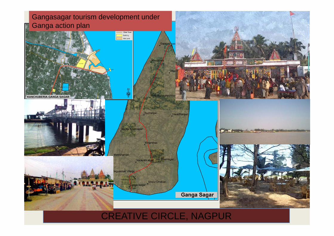
Adventure sports : 1
•Adventure sports : rock climbing, railing •Sand riding, biking and 4-wheel race
CREATIVE CIRCLE, NAGPUR 24
•After checking the possibility and safety for the site, the sports and the infrastructure required for them shall be proposed.

OTHER SPECIAL FEATURES
The rides and games are selected with a prime notion to create a place where new and modern entertainment facilities will be offered to peoplefacilities will be offered to peopleThe rock – climbing facility will also offer a opportunity for training and adventure.The lighting effect at night will glow the complete complexThe lighting effect at night will glow the complete complex to make it a focal point of the surrounding
The signage at various levels will be for easy accessibility and customer care.
The contours shall be treated with garden terrace to create a unique experience to the visitors.
High tech development with walking way, lighting effect,
CREATIVE CIRCLE, NAGPUR 25
beautiful garden will make the spot an example of its own identity.

City development plan of twenty one cities of Maharashtra state, India
• In association with aXYKno consulting ltd., Nagpur
Th j t t it d l t l f t t iti
Sr. No.
City Population 2011
Projected Population
Area (Ha)
• The project was to prepare city development plan of twenty one cities, situated in various districts with varied nature and potential. Few of the cities are twin cities. The work included: detailed analysis of their SWOT resulted into planning of development with different visions. Survey of area suggestion for thematic vision, strategies and demand
No. n 2011 Population 2038
1Achalpur‐Paratwada 112293 143437 1603
2 Chikhaldara 5151 7412 394
calculation for various sectors, stress on increase of green percentage and development of all parks and water bodies, detailed project report for water supply/sewerage, This City Development Plan is prepared to make the city to be proactive in strategizing its future till 2038. It is suggested that the ‘FUTURE CITY’ will meet again in next five year to
3 Nandurbar 111067 161499 3241
4Shirpur‐Varwade 76905 130396 1459
5 Shrigonda 31134 46763 86976 Desaiganj 27453 43332 2636 8suggested that the FUTURE CITY will meet again in next five year to
take stock of the progress made in implementation of the strategies and will draw up the revised action plan for faster further development. The CDP, with UADD guidelines and JNNURM guidelines, aims to upgrade the infrastructure standards qualitatively.
6 Desaiganj 27453 43332 2636.87 Gadchiroli 53833 105111 2928.98 Buldhana 67470 109372 10829 Tumsar 46091 65218 756.510 Sindkheda 20256 24307 60012 Sawantwadi 23854 28406 67813 Malvan 19608 21587 65014 Alibag 21759 29558 18115 Ratnagiri 76052 103641 104916 Panvel 180464 4233020 121716 Panvel 180464 4233020 121717 Matheran 4388 3970 70018 Wardha 105543 107929 90419 Gondia 132889 168909 180820 Khamgaon 94259 121142 133621 Shegaon 59766 86699 583
o Satarao Konkan Division 6 townso Nashik Division 5 towns
26CREATIVE CIRCLE, NAGPUR
o Amravati Division Part 1 5 townso Nagpur Division 6 towns

CITY DEVELOPMENT PLAN SATARA• Preparation of City Development plan with a vision of “AN
ECO‐HERITGE‐TOURISM‐AGRO TRADE CITY " A city with quality, service, efficiency & Environment.
• A MAHARASHTRA NAGAROTTHAN ABHIYAN PROJECT
• Development of THE CITY on INTERNATIONAL STANDARDS.
• Assessment of city potentials including, Heritage, Tourism, Industry Trade Agriculture etcIndustry, Trade, Agriculture etc.
• Proposing Development Rules and Regulations towards better development of city and plan for the development of Heritage Structures, Sewerage Network, Water Supply Network, River Basin Rejuvenation Plan;
S ti t d it d l t f M i i l• Suggestions towards capacity development of Municipal Council.
• Suggestions towards Dilapidated housing, Slum housing.
Putting Satara on international tourism map by Creating new
brand image. The Preparation and Adaptation of local area tourism policy to achieve high speed tourism development : To contribute to sustainable GDP growth, job creation, redistribution and t f titransformation:
Formulate marketing strategy and plan for Effective international and domestic marketing; Upgrade/ extend national web-site and link to other sites/ platforms
• GDP growth, job creation;• Redistribution and transformation• Increasing tourist volumes;• Increasing tourist spend;• Increasing length of stay of visitors;• Improving the geographic spread of visitors;
I i li
27
• Improving seasonality patterns.
CREATIVE CIRCLE, NAGPUR

“A Cotton City”Achalpur : CDP 2038
Proposal: • Developing Achalpur city as a
“Cotton Hub”.• Impetus to Agriculture and Agro
Based Industries.• City Beautification.• Agro forestry and Agro Tourism.g y g• Religious Tourism.
Proposed Land Use Classification-Achalpur 2038

Proposed Land Use Classification 2038
Land use Area Calculation Area in Sq m
Area in Ha
Overall area %
Developable area %
“Discover Chikhaldara” CDP 2038 Proposal:• Artificial lake and lake front Residential 726700 72.67 18.44
Commercial 159200 15.92 4.04Public - Semi Public Utility 482600 48.26 12.25Green and Open Spaces 314300 31.43 7.98Tourism 423700 42.37 10.75Transport 590900 59 09 14 99
• Artificial lake and lake frontdevelopments.
• Viewpoints and tourist Attractions.• Religious Tourism• Heritage Tourism Transport 590900 59.09 14.99
Total Developed Area 269.74 68.45Agriculture 1118700 111.87 28.39 90.06Water bodies 123400 12.34 3.13 9.93Total Developable Area 1242100 124.21 31.52Total Area 394 100
• Heritage Tourism• Adventure Tourism• Medical Tourism• Stay in Chikhaldara• Shopping Paradise at city centreShopping Paradise at city centre• Agricultural Employability
Avenues
Chikhaldara : Proposed Land Use Map for 2038

City Development Plan Of Nine Cities Of Madhya Pradesh State, India,
Th k d k S fThe work undertaken were : Survey of area suggestion for thematic vision, strategies and demand calculation for various sectors, stress on increase of green percentage and development of all parks and water bodies, detailed project report for water supply/sewerage . This City Development Plan is prepared to make the city to be proactive in strategizing its future till 2035. It is suggested that the ‘FUTURE CITY’ will meet again in 2015that the FUTURE CITY will meet again in 2015 to take stock of the progress made in implementation of the strategies and will draw up the revised action plan for faster further development. The CDP, with UADD guidelines d JNNURM id li i t d thand JNNURM guidelines, aims to upgrade the
infrastructure standards qualitatively.
• Balaghat
• waraseoni• waraseoni
• Saikheda
• Sausar
• Chourai
H i• Harrai
• Piplanarayanwar
• Barghat
• Lakhnadon
30CREATIVE CIRCLE, NAGPUR

CITY DEVELOPMENT PLAN BALAGHAT• Preparation of City Development plan with a vision of “AN ECO‐Preparation of City Development plan with a vision of AN ECO
TOURISM –HEALTH CITY " A city with quality, service, efficiency & Environment.
• A DFID FUNDED PROJECT
• Development of Balaghat city as a Tourism center of International levellevel.
• Assessment of city potentials including, Tourism, Industry, Trade, Agriculture etc.
• Proposing Development Rules and Regulations towards better development of city and plan for the development of Heritage Structures, Sewerage Network, Water Supply Network, River Basin Rejuvenation Plan;
• Suggestions towards capacity development of Balaghat Municipal Council.
• Suggestions towards Dilapidated housing, Slum housing. gg p g, g
Putting Balaghat on international tourism map by Creating new brand image. The Preparation and Adaptation of local area tourism policy to achieve high speed tourism development : To contribute to sustainable GDP growth, job creation, redistribution and g , j ,transformation:
Formulate marketing strategy and plan for Effective international and domestic marketing; Upgrade/ extend national web-site and link to other sites/ platforms
• GDP growth job creation;GDP growth, job creation;• Redistribution and transformation• Increasing tourist volumes;• Increasing tourist spend;• Increasing length of stay of visitors;• Improving the geographic spread of visitors;
31
p g g g p p ;• Improving seasonality patterns.
CREATIVE CIRCLE, NAGPUR

CITY DEVELOPMENT PLAN WARASEONI
P i f Ci D l l i h i i f “AN ECO AGRO• Preparation of City Development plan with a vision of “AN ECO‐AGRO‐TRADE CITY " A city with quality, service, efficiency & Environment.
• A DFID FUNDED PROJECT
• Development of WARASEONI city as a Eco‐ city with CANADIAN standard
• Assessment of city potentials including, Tourism, Industry, Trade, Agriculture etc.
• Proposing Development Rules and Regulations towards better development of city and plan for the development of Heritage Structures, Sewerage Network, Water Supply Network, River BasinStructures, Sewerage Network, Water Supply Network, River Basin Rejuvenation Plan;
• Suggestions towards capacity development of Balaghat Municipal Council.
• Suggestions towards Dilapidated housing, Slum housing.
o Making the city Environmental sustainable by adopting “Integrated Community Sustainability planning” (to address climate change and encourage the development of healthier, less costly and more sustainable
i i ) i b C di d dcommunities.) i.e. by Canadian standards. o As the pollution level of water, soil and air is almost under allowable limits. Further stage ‐Maintaining zero carbon standards for environment. Use of gas as fuel to stop danger of future air pollution. Ban on diesel vehicles and conversion of them on GAS.
Pl t ti f t lik t t t il i d d to Plantation of grass, trees like neem etc. to stop soil erosion and dust particles in the air and to have pure air. o Balanced mix of hard and soft landscape at problematic areas to reduce dust. Cleaning of lakes, nallahs and de‐siltation of river, installation of green bridges to purify water of water bodies. o Rainwater harvesting with such purified water will reduce contamination
32 CREATIVE CIRCLE, NAGPUR
o Rainwater harvesting with such purified water will reduce contamination of ground water and to increase ground water table.

BARGHAT : CDP 2036 “A Lake City ”
‐ FERTILE BELT
KANHIWADAWAY TO
Greenspace/farm
‐ IRRIGATION NETWORK – NO SCCARCITY OF WATER
‐ LOCATION – CLOSE TO SEONI, JABALPUR. ON ROAD TO BALAGHT – KANHA FROM SEONI
KHOONT
WAY TOBALAGHAT
WAY TO SEONI
warehouse/industry
Housing
RecreationGreenspace/farm
Commercial/institutional
WAY TO MAGARKATHA
WAY TO MANDHIHousing
Recreation
Greenspace/farm
Greenspacecommercial
WAY TO MAGARKATHA
WAY TO BAMHANI
WAY TO MANEGAON
g
Rejouvenating streamCommercial/institutional
p
Pisiculture ‐ PLEASANT WEATHER‐ USE OF NATURAL SLOPES FOR
WATER DISTRIBUTION AND DRAINAGE
‐ AQUA‐FARMING OF FISHERIES, PRONS
‐ FARMING

‐TOURISM (WATER SPORTS AND RESORTS)
SAUSAR : CDP 2036
GROWTH NODES•SAUSAR – Tourism (Resorts and Water Sports), Handloom( p )Training Center•GUJARKHEDI - Ring road bisects Gujarkhedi•BELGAON - Ware House, Transport Nagar and Industries•JAM- Holiday Homes and Meditation Center
A REVERINE TOWN
‐HANDLOOM TRAINING CENTER
RING ROAD
INDUSTRIESWARE HOUSING
WATER TOURISM
TRANSPORT NAGAR
HOLIDAY
MEDITATION CENTER
HOLIDAY HOMES

The work undertaken were : Survey of area designing planning and estimation
Various infrastructure works, social facilities and amenities in Gurgaon as per DP2031
area, designing, planning and estimation and tender preparation of various works as per the development plan 2031. the projects include providing of various infrastructure like water supply etc. and social infrastructure in Gurgaon and in villages of its extended limits. The projects includes:
• water supply schemes, Pumping stationstation
• Sewer systems, STP, Boosting station
• Storm water drains
• Club house, Choupal, Community C ub ouse, C oupa , Co u tycenters
• School buildings, old age home
• Office buildings, firefighting
• Dispensary, multilevel parking p y, p g
• Lake beautification, parks
• Roads, traffic islands
• Village upgradation
35

36

TECH CHAND NAGARLAKE SITE FORFOR DEVELOPMENT
DWARKA EXPRESS WAY
TRAFFICRESIDENTIAL CRESIDENTIAL
AREA

Located close to the collector office is a residential colony built in pre‐independence period, named EAC y p p p ,colony. The object of this project is to redevelop the area and to solve the traffic problem of busiest Shastri Chowk located close to the site.
The stretch of land is 17.18 ha. With the FSI as 2.5, the allowable built up is 42.95 hectare. The triple basement is above the allowable built up.
The proposal suggested included1. Plaza on ground with many visual attractionsexhibitions, music shows, light shows, hologram, liquid diesel , laser shows and musical fountain show1. Wide wayside for traffic movement ( vehicular and
pedestrian)2. Pedestrian walkway3. Commercial complexes -3 numbers
• Auditoriums banquet halls, meeting halls• Sports like bolly-alley, billiards dashing cars, play
zones for adults• Sports for kids like kids-cove, play zones, video
games etc.• Entertainment attractions like 3D/ 6D theatres, Gym,
SSpa and health clubs• Eateries zone, showrooms Underground shopping
cum exhibition space including relocated shops (Xerox etc. ) from Baloda Road.
4. Underground parking in two levels5 G d ith i t f fl / h b5. Gardens with variety of flowers / herbs6. Underground vehicular way7. Office complex-1number8. Relocation of existing households9. and shopping arcade 10 Double grade security
38
10. Double grade security11. Use of solar lighting12. Green building norms13. Recycling grey water 14. Rainwater harvesting

PARKING
RESETTLED HOUSING UNITS
COMMERCIAL i
HIGH‐END HOUSINGREVOLVING RESTAURANT
HIGH END HOUSING
PLAZACO CIAL ii
DOUBLE BASEMENT PARKING
SHOPS/AUDITORIUM/BANQUET
COMMERCIAL ii
GARDEN
GARDENREUSE OF GREY WATER
SHOPS/AUDITORIUM/BANQUET AT ‐1 LEVEL
SWAWLAMBI PLAZA PLAN , RAIPUR RAIN WATER HARVESTING
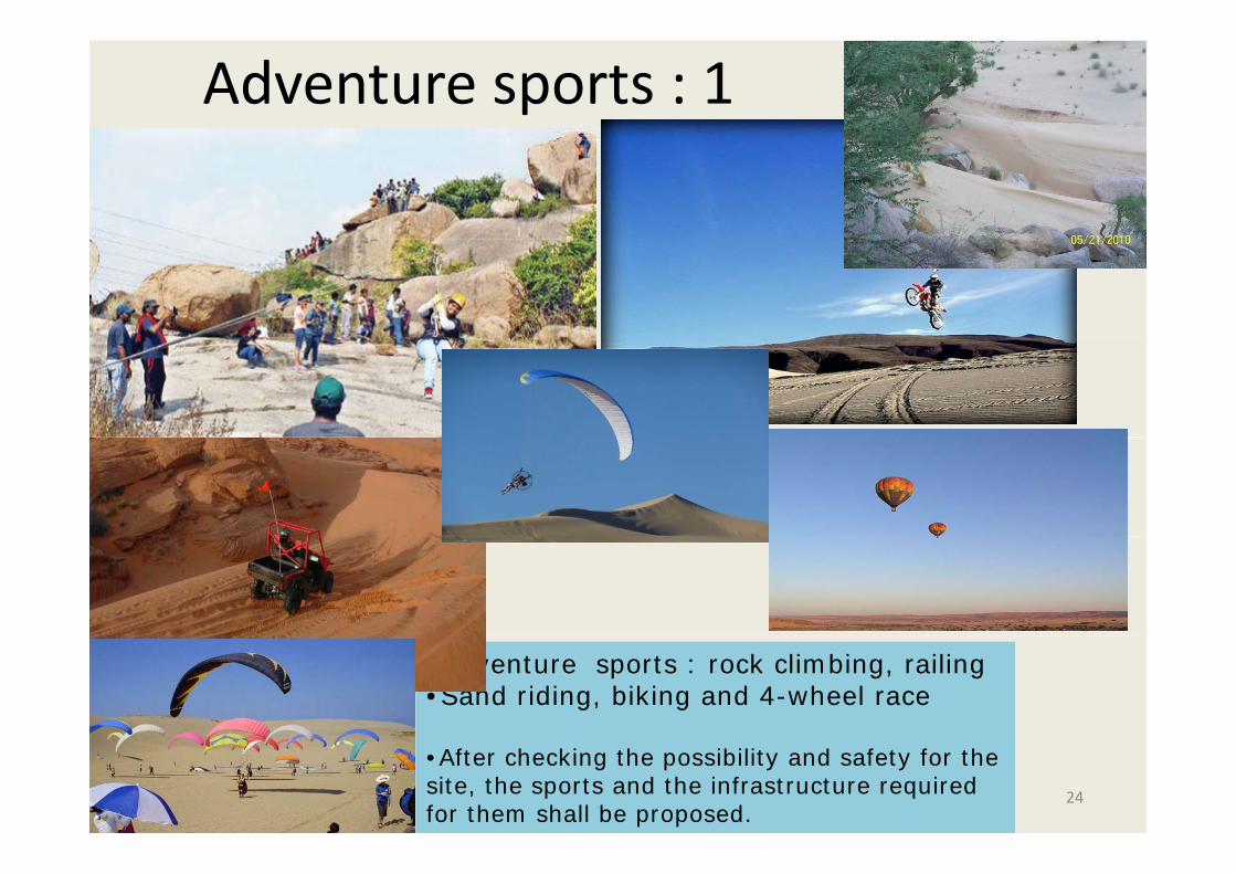
PLAZA at Ground Level
Barrier free Design
Public Plaza with many attractions
Light shoots
Fountain shoots
Water fall
Water tower
Water Channel
Inter‐active WALLInter active WALL
Garden with various flowering shrubs
Garden under Front Commercial Buildingg
Statue and Sculpture to symbolize district
Sun dial

LEVEL ‐1 PLANLEVEL 1 PLAN
LEVEL ‐1 – A WORLD WITHIN REACH
LEVEL ‐2 – PARKING ZONE
WITHIN REACH AuditoriumCultural center Multiplex under
A Vehicular Under Way To Connect G E Road To Jail Road
CAR PARKING FORDistrict COURT
Multiplex under front commercial 3‐ D/ 4‐D theatreBanquet halls
• District COURT• Office Zone• Public Plaza • Leisure Zone
Shops / sovereign shops

District Tourism Plan Of Eight Districts Of Maharashtra, India; A Maharashtra Tourism Development Corporation Project
SINDHUDURG district : area 5207 km; population 848,868(census 2011); 1541.21 crores•Amravati district: area of 12,235 km²
d l ti f 2 887 826 band population of 2,887,826 by census 2011 cost 429.82 crores•YAVATMAL district : Total population 2,775,457 (census 2011); area of 13584 sq. km; cost 104.66 crores•GONDIA district : Total population 13,22,635 (census 2011); area 5,640.51 sq.km; cost 100 crores•WASHIM district: area of 5,150 sq km; population 1,196,714(census 2011); costpopulation 1,196,714(census 2011); cost 109.49 crores GADCHIROLI district :Total population 1,071,795 (census 2011); area of 14,412 km2 ; 154.88 crores•JALNA district : area of 7 612Sq Kms•JALNA district : area of 7,612Sq.Kms; population 1958483(census 2011); cost 757.02crores •BHANDARA district : Total population 11,98,810 (census 2011); area 3716.65 sq km. cost 257.21crores
42

GATE WAY TO SINDHUDURG DISTRICT
•The entry points to the district which Kharepatan
Vijyadurg
are easily approachable from rest of the state and country are :
Rail Heads‐ Sawantwadi Kudal Oras
GaganbavdaRail Heads‐ Sawantwadi, Kudal, Oras& KankavavliRoad gateways‐ Kharepatan, Kankavli, Sawanwadi, Amboli, Redi, Banda and
Phonda ghatKankavaliDodamargAirport – Goa and Chipli,Malvan(proposed) Water – Vengurla
Malvan
Water Vengurla
Extra Special stress in terms of tourism proposal is given to Malvan the potential gateway after operation of Chipli Airport
Oras
KudalSawantwadi And
the destinations located close to Goa border to attract tourist coming to Goa. Last year the number of tourists coming to Goa had crossed 25
AmboliSawantwadi
Redi
Vengurla
lakh numbers and this is year it is expected more. Also to catch the over-sprawl of tourists in Goa and also to provide standard/economical stay alternatives to the tourists who return from Goa
RediBanda
Kiranpani
for not finding loading space every year. Goa Dodamarg
Sindhudurg District Tourism Master Plan

KHAREPATAN VALLEY/ GAGANBAWDA GHAT
Sindhudurg District Tourism Master Plan

Sindhudurg Malvan
Finding Tunnel Below SeaFinding Tunnel Below Sea & Using itSegregate Fisher areaWater SportsWater SportsTowersFloating Restaurant
R W
AccommodationRestaurant Rope WayRestaurantShowsWater Screen
Sindhudurg District Tourism Master Plan

VENGURLA TOWN
Sindhudurg District Tourism Master Plan

FILM CITY AT DEVGAD
Location for film city
Devgad PortDevgad Port
Sindhudurg District Tourism Master Plan

Sports Complex on table land Malvantable land Malvan
Recreating Maratha Period
Infrastructure/facilities proposed –•Parking facility•Drinking water•Public toilets •Paving & Signage •Solar Light•Places for pause and site viewing pointspoints •Infrastructure for various shows like laser, liquid diesel, halogrom etc.•Luxurious class accommodation •Resort and cottagesResta rants offering m lti c isines•Restaurants offering multi cuisines
•Shops and souvenirs •Garden, furniture and infrastructure development •Golf ground•Various sport ground like horse riding etc.•Solid waste management•Seating and shaded resting places Sindhudurg District Tourism Master Plan

Rock sculpture at Malvan Creek
• Infrastructure/facilities –• Parking facility• Drinking water• Public toilets
P i & Si• Paving & Signage• Rock sculpture • Solar Light• Camping area with tent
accommodation
Rock sculpture
Rock sculpture
• Restaurants offering multi cuisines
• Shops and souvenirs • Garden, furniture and
infrastructureRock sculpture infrastructure development
• Solid waste management• Seating and shaded resting
places W h & lif d• Watch tower & life guards
• Water sports • Cable car
Rope way
Resort and cottagesOther infrastructure
Rope way
gOther infrastructure
Sindhudurg District Tourism Master Plan

Redi Fort & Creek
Sindhudurg District Tourism Master Plan

SAWANTWADI TOWNCraft village at Sawantwadi
town
Craft village
museum of traditional artsConservation centers for artsTraining center Research center to developedResearch center to developed the art for new demandMarketing center/craft marketConvention hall/ exhibition ground
For export exhibitionsMango festivalsFish festivalsFish festivals
V star hotelsTourists Home/cottages for longerstay
Sindhudurg District Tourism Master Plan

KHAREPATAN TOWN
NH-17( PANVEL-GOA-EDAPPALLY ROAD)
Sindhudurg District Tourism Master Plan

Padvane beach & Heritage -Vimleshwar Cave Temple, near Wada,at Devgad Taluka
Sindhudurg District Tourism Master Plan

Nivti Fort& Beach
ExclusiveBeach
Ni ti F tNivati FortTo be converted into5 Star Accommodation
Creation of safe beach
Parking
Lift
Sindhudurg District Tourism Master Plan

Eco‐village : Kavthan AT TEREKHOL RIVER /KavthanKHADIKHADI
Kavthan village
Sindhudurg District Tourism Master Plan

Amboli Valley Proposal
Infrastructure/facilities proposed –p p•Parking facility•Drinking water•Public toilets •Paving & Signage •Solar LightSolar Light•Places for pause and site viewing points •Infrastructure for various light effectsR t d tt
Cable car•Resort and cottages•Restaurants offering multi cuisines •Shops and souvenirs •Garden, furniture and infrastructure development •Adventure sports of rock climbing •Solid waste management•Seating and shaded restingSeating and shaded resting places •Sliding cable car•Paragliding / bungee jumping•Decks at various heights with liftsSindhudurg District Tourism Master Plan

HIRANYAKESHI
• Infrastructure/facilities –• Parking facility• Drinking water• Public toilets • Paving & Signage • Solar Light• Camping area with tent
accommodation • Restaurants offering multi g
cuisines • Shops and souvenirs • Garden, furniture and
infrastructure development • Solid waste management• Seating and shaded resting places
Sindhudurg District Tourism Master Plan
g g p• Watch tower & life guards• Water sports • Glass lift and decks at various
heights
View PointsAdventure

Underwater restaurant and viewing gallery for live museum at Tarkarli nearmuseum at Tarkarli near
coral rocks
there are numerous submerged and gexposed rocks in the vicinity, providing an ideal substratum for marine life.The marine flora andThe marine flora and fauna here pertain to sea anemones, mollusks, polychaetes, pearl oyster, corals, seaweed and mangrovesenchanting accommodation at the Akeri Rest Houses of the Forest Department.Snorkeling
TARKARLI..it is a paradise of tiny islands and hamlets and beautiful casuarinatrees…it is in sindhudurgdistrict of maharashtra,near karliriver which meets the Arabian sea the blueArabian sea..the blue beach meets the sparkling blue sea..tall green trees and virgin beaches attracts everyone from 15 to 55yrs.Sindhudurg District Tourism Master Plan

Vengurla Beach : Tortoise Park
TORTOISE PARK
Sindhudurg District Tourism Master Plan

Honeymoon Island Tourism at MHARTALE, REDI
Island
MHARTALE island
Honeymoon cottages
Sindhudurg District Tourism Master Plan

Tourism potential sitesCONCEPT:
ZONINGResorts, Hotels
ZooChikhaldara Municipal Area
Waterbody
Tourist
Tourist
Existing villagesSt H t lT i t
Tourist
ChikhaldaraLOCATION = 20°32' and 21°46' north latitudes and 76°37' and 78°27' east l it d
Adventure tourism
Star Hotels
Institutional, Spiritual
Residential
Residential Schools
Tourist
ChikhaldaralongitudesAverage Elevation = At Melghat and Chikhaldara tahsils. The crests of the range attain an average elevation of about 1000 meters, the highest point being variant at a
Conto
height of 1,177.75 meters.Population = 2,887,826 census 2011Area = 12,235 square Km
ured
LevelAmravati District Tourism Master Plan

MelghatSemadoh
Tourism potential sites
RaipurChaour
Tapi River
MTDC RetreatTiger Sanctuary
KolkasTapi River
Raipur RoadT b d
Harisal Sema
dohKeli
r
Kolkas
Chaourakund
F.R.
TarubBerdab
arda lake
Didamba lake
Bori
SNAKE PARK
TarubandaHarisalKotha
BoriChikhaldara
anda
Belkunda F.R.
lakeCANOPY WALK TENT WITH TOILETS
Narnala
Dhargad
Mahadeo
Gullaghat lake
ROCK LANDSCAPE/ PLANTATION STAR GAZING TELESCOPETREE HOUSE
NATURE TRAILS PHOTOGRAPHY ELEPHANT SAFARI
Amravati District Tourism Master Plan HIDE BIRD WATCHING JUNGLE SAFARI

ChikhaldaraRecreatingold glory
Rehabilitating old Rest Houses
PlantationsGolf Course
Amravati District Tourism Master Plan
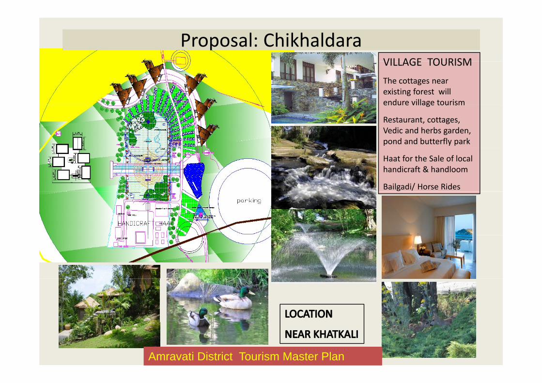
Proposal: ChikhaldaraVILLAGE TOURISMVILLAGE TOURISM
The cottages near existing forest will endure village tourismendure village tourism
Restaurant, cottages, Vedic and herbs garden, pond and butterfly park
Haat for the Sale of local handicraft & handloom
Bailgadi/ Horse Rides
Amravati District Tourism Master Plan

Proposal: ChikhaldaraFacility CreationJ l C i Facility CreationJungle Camping
Canopy WalkTree ClimbingRest HouseSummer Camps(water supply – concern)
Panch karma/ naturopathy Health Panch Karma
spa and resort with cottages
Located near
Lounge Restro
Located near BeerTalao With
Waiting lounge, Restaurant, Health spa, dining and cottages
The lighting effects with fountain will enhance the beauty at
Cottages
ynight
Garden surrounding the complexthe complex
Amravati District Tourism Master Plan

BHIM KUND RAIN WATER HARVESTINGCOFFEE PLANTATIONPRINCE OF WELLINGTONMONUMENT
BRITISH REST HOUSE BEER TANK BRITISH CEMETARY
C R E A T I V E C I R C L E , N A G P U R
BRITISH REST HOUSE BEER TANK BRITISH CEMETARY
OTHER ATTRACTIONSAmravati District Tourism Master Plan

LOCATION = 21.17°N 79.65°E Average Elevation = 244 meters Population = 11,98,810 census 2011Area = 3716.65 square Km
Several Circuits are PossibleBased on Tehsil, Inter and Intra Tehsil
Circuits are 2, 3, 4, 6, 1, 10 days as well.
Large Circuit
TOTAL 52 LOCATIONSMOHADI
Medium Circuit
Small Circuit
NagthanaKhodgaonChoundeshwari DeviNeriBid Tajmehandij
DarbarLAKHANDURMangli BandhChhapradAsola (Shiv Mandir)
ROPE WAY
Asola (Shiv Mandir)Rohani (Tukdoji)Bhagdi PahadiMandhalDighori
•It is fondly called as the 'District of Lakes’. •District is rich in forest, beautiful l k t l fl d f
GUEST HOUSE REJUVENATION
JUNGLE CAMPCharbatti
Wainganga RiverBawanthadi RiverNarrow Guage Line
lakes, natural flora and fauna have enhanced natural beauty and grandeur of the district•The entire region is surrounded by the hills, rivers and dams, and other natural resources GUEST HOUSE REJUVENATION
Bhandara District Tourism Master Plan
gBhivkhedkiSonegaon LakeMahachhatrapBaasamudraBandarzira
natural resources.•River Wainganga flows through the district.

BHANDARA
LIGHT AND SOUND SHOW
BHANDARA TOWN : PROPOSAL: TOURISM HUB
Bhandara District Tourism Master Plan

6.2.2 a1 Connectivity:•Air connectivity: The nearest airport is at Nagpur at 60km from Bhandaraand 105km from Pauni..
PAUNI
•Railway: Nearest railway station is Bhandara and Tumsar.•Road connectivity: 45km from Bhandara, the district head.
RESTORATIONRESTORATIONLIGHT AND SOUND SHOWWATER SPORTS AT LAKECANOE / KAYAK COMPETITIONSWHITE WATER RAFTING ON WAINGANGAWHITE WATER RAFTING ON WAINGANGA
Bhandara District Tourism Master Plan
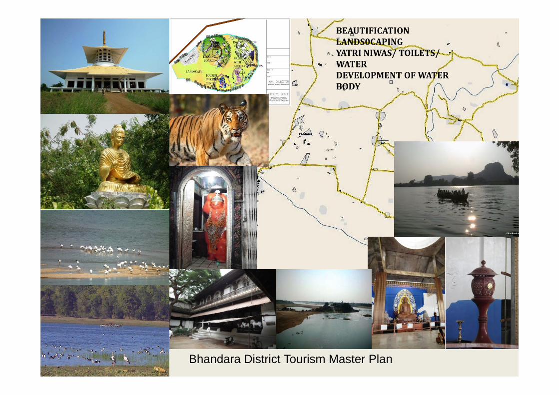
BEAUTIFICATIONLANDS0CAPINGYATRI NIWAS/ TOILETS/ WATERWATERDEVELOPMENT OF WATER BODY
Bhandara District Tourism Master Plan

Coordinates: 21’3 North Latitudes and 75’4 East to 76’4 East Longitude MSL –502m
R
502mDistrict population 2011 –1958483District Area - 7,612 km2
(2,939 sq mi)
N
A
G
P
U
( , q )
R
C L
E
,
N
V
E
C
I
R
R
E
A T
I
C
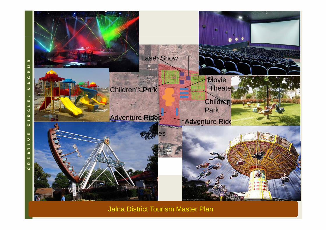
Jalna District Tourism Master Plan
R Laser Show
N
A
G
P
U
MovieTheaterChildren’s Park
R
C L
E
,
N TheaterChildren s Park
Ad t Rid
Children’sPark
V
E
C
I
R
Adventure RidesAdventure Rides
Adventure Rides
Adventure Rides
R
E
A
T
I
C
Jalna District Tourism Master Plan

R
N
A
G
P
U
R
C L
E
,
N
V
E
C
I
R
Proposal
R
E
A
T
I p
•Resorts & Cottages•Camping site•Restaurant offering varied cuisines •Tourist information centre
•Places for Rest and pause•Watch Towers & Photography ride•Heritage Renovation to convert it into HotelC
Archeological Site Gadhi, ManthaCo-ordinates: Latitude 19°40′46.8″N Longitude 76°23′28.2″EThis place is located in Sawargaon village in Mantha taluka. It looks like fort from outside with high stone walls
•Drinking water & Public Toilets•Heritage Renovation to convert it into Hotel•Tourist Guide Training Centre
p g g gof 20 feet in height. This was a form of accommodation in olden times. Presently one family stays inside the structure.
Jalna District Tourism Master Plan

Shah Rustam Baba/Chakradhar swami Temple/ Godavari, Ambad
R
N
A
G
P
U
R
C L
E
,
N
Proposal
V
E
C
I
R
p•Fountain•Budget Accommodation•Drinking water & Public Toilet•Restaurant offering varied cuisines
R
E
A
T
I g
•Prayer Hall & Meditation centre•Boat rides •Water / River Sports•Heritage Renovation
C g
•Lighting and Landscaping
•Linkages – This place is 62km away from Jalna. There are regular private and government bus services available to take you to the attraction and get around the city.•Lodging/boarding – Facility for night stay is not available. Private restaurants are not present near this site. But one can choose proposed g g g y g y p p pbudget accommodation. Guest houses, lodges and economy to deluxe hotels at moderate rates located close to the main town center.
Jalna District Tourism Master Plan

Proposed TOURISM SITES in GondiaSITES in GondiaDistrict.
WildlifeReligiousWater bodyWater bodyAdventureHeritage/FortgUnusual
A high tourism potential District• Jungles & Wildlife• Jungles & Wildlife• Bird Watching• Leisure tourism like Water sportssports• Adventure tourism• Religious Tourism• Heritage & historical Tourisme age & s o ca ou s• Trekking, climbing, rafting
Gondia District Tourism Master Plan

Nagra, Gondia
Infrastructure/facilities•Parking facility/ Landscaping•Guide•Multipurpose Hall•Public toilet and Drinking water•Public toilet and Drinking water•Signage and Road Connectivity•Structure Renovation•Lighting to Structure•Garden & Landscaping Gondia District Tourism Master Plan

KACHARGAD CAVES
•Infrastructure/facilities dproposed
•Restaurant•Accommodation•Watch TowersWatch Towers•Public toilets•Drinking water facility•Bird watching hide/ Jungle SafariT il d l•Trail development
•Cultural heritage programs
Gondia District Tourism Master Plan

Shiv Temple at Markanda (Talukha-. Chamorshi)
Accomodation: Rest House, Chamorshi, Ashti, Gadchiroli, Dharmashala at Markanda.Distance from Gadchiroli : 45 km SouthDistance from Gadchiroli : 45 km SouthDistance from Chamorshi : 8 km westFavourable Season for visit : October to JuneTravelling : By roadways, BusAnnual Fair : MahashivratriAnnual Fair : Mahashivratri
In Brief: Famous for its ancients & "Hemandpanthi" style temple of Lord Shiva on the bank of river Vainganga where it changes its direction of flow to north from south.The markanda is on south-west of Chamorshii Taluka. The nearest railhead is Mul. Markanda is connected with Gadchiroli by Road. Temple similar to famous Khajuraho
Gadchiroli District Tourism Master Plan
The nearest railhead is Mul. Markanda is connected with Gadchiroli by Road. Temple similar to famous Khajuraho temples.

Shiv Temple at Markanda (Talukha-. Chamorshi)
Gadchiroli District Tourism Master Plan

River Bank near Markanda temple
Infrastructure/facilities required/ proposed –
Markanda temple
proposed•Parking space for 500 vehicles at time of fair/ Normally for 50 vehicle•Taxi stand•River bank development+ ghat d l tdevelopment •Road upgradation for 3km•Railway track from Mul to Chamorshi (25kms)•Water sports +Boating
Road upgradation
Ghat development
•Restaurant •Watch Towers +Security and surveillance•Budget accommodation ( for 50 persons) •Places for Pause/Rest(8/10 chhatries)•Public Toilets (12units of w/c, bath
Development site
Public Toilets (12units of w/c, bath complex)•Resort and cottages ( 4/5 cottages) •Heritage conservation•Solid waste management •Drinking water facilityDevelopment site •Drinking water facility •Garden and signages •First aid facility •Souvenir Shops•Electrification/ solar lighting
Gadchiroli District Tourism Master Plan

Wairagad Fort, Five Carved Stone (Pachpande), Bhadreshwar Temple and Gorjai temple at Wairagad
Distance from Gadchiroli : 39 km South ; Favourable Season for visit :
Infrastructure/facilities required/ proposed –•Parking space for 50 vehicles
Throughout the year; Travelling: By roadways, Bus,
•Taxi stand•River bank development+ ghat development •Road upgradation for 5km•Water sports +Boating p g•Watch Towers +Security and surveillance•Budget accommodation ( for 50 persons) •Restaurant
Road upgradation
•Restaurant •Places for Pause/Rest(8/10 chhatries)•Public Toilets (3units of w/c, bath complex)•Resort and cottages ( 4/5 cottages) •Heritage conservation•Solid waste management •Drinking water facility •Garden and signages •First aid facility y•Souvenir Shops•Electrification/ solar lighting
In Brief: Adishakti Devi Temple is situated at Wairagad near Gadchiroli town. The temple enshrines the idol of Adishakti Devi, found during the excavation conducted in 1986. The idol has four hands and is an example of the , g pexcellent quality of carvings undertaken by the sculptors of the erstwhile era. Devotees throng the place throughout the year.
Gadchiroli District Tourism Master Plan

Binagunda village, Bhamragad taluka : Rural Tourism With Group Of Villages
Binagunda village
Bhamragad
Triveni Sangam
Town
Gadchiroli District Tourism Master Plan

Kovardev temple, Zadapapda, Pendhri village tahsil: DhanoraForest/ River/ Rocks
Infrastructure/facilities required/ Infrastructure/facilities required/ proposed –•Parking space for 50 vehicle•Taxi stand•Multipurpose hall ( 200p capacity)•River bank development+ ghat development •Road upgradation for 6.5km•Water sports +Boating •Restaurant •Watch Towers +Security and surveillance•Budget accommodation ( for 15 persons) •Places for Pause/Rest(8/10 chattries)•Public Toilets (12units of w/c bath•Public Toilets (12units of w/c, bath complex)•Resort and cottages ( 4/5 cottages) •Nature conservation•Solid waste management D i ki f ili•Drinking water facility •Garden and signages•First aid facility •Souvenir Shops•Electrification/ solar lighting / g g•Telephone Facility •Machan•Village tourism•Forest safari •Rock climbing facility•Rock climbing facility •Cultural heritage
Gadchiroli District Tourism Master Plan

Shiv Temple (Hemadpanthi Temple), Thanegaon,and Arat‐Tondi Mahadevgad Temple, Tahsil: Kurkheda & Surrounding Forest
Infrastructure/facilities required/ proposed –q p p•Parking space for 50 vehicle+Taxi stand•Multipurpose hall ( 200p capacity)•River bank development+ ghat development •Road upgradation for 17km•Water sports +Boating at two locations p g•Restaurant •Lake beautification •Watch Towers +Security and surveillance•Budget accommodation ( for 15 persons) at Kurkheda •Places for Pause/Rest(8/10 chattries)•Public Toilets (2units of w/c, bath complex)•Resort and cottages ( 4/5 cottages) at Kurkheda•Nature conservation•Solid waste management •Drinking water facility •Garden and signages •First aid facility •Souvenir Shops•Electrification/ solar lighting •Telephone Facility M h•Machan
•Village tourism•Cultural heritage
Gadchiroli District Tourism Master Plan

Bodhisirihill
•The project is designed to attract visitors/ citizens in large number for leisure, health and entertainment. •The ACTIVITIES INCLUDED are of HIGH REVENUE GENERATING and facilities are provided for all age groups, corporate functions and frequent visitors to have unique experiences. •The project shall be developed by VGTM UDA with selective parts on PPP/lease basis.
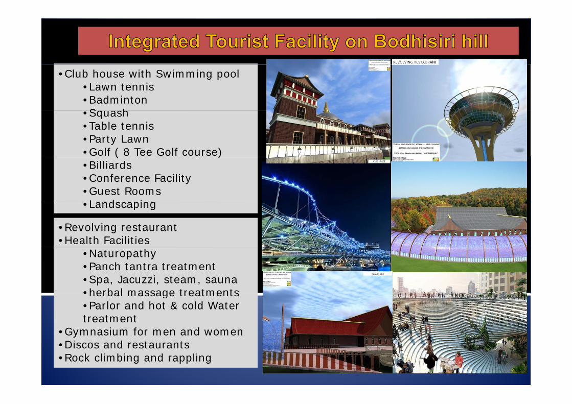
•Club house with Swimming pool•Lawn tennis•Badminton S h •Squash
•Table tennis•Party Lawn•Golf ( 8 Tee Golf course)( )•Billiards•Conference Facility•Guest RoomsLandscaping•Landscaping
•Revolving restaurant •Health Facilities
•Naturopathy •Panch tantra treatment •Spa, Jacuzzi, steam, sauna •herbal massage treatments•herbal massage treatments•Parlor and hot & cold Water treatment
•Gymnasium for men and women•Discos and restaurants •Rock climbing and rappling

•Children’s play area •Rides •Edu-entertainment zone•Kid’s play zone with science games•Blaster boats (electric)•Kid’s cove•A skating ring (30MX30M) •Kid’s video games and Kid s video games and simulators•Dance machine, emotional sense crew racer
•Adult Entertainment3d/4d/6d virtual 3d/4d/6d virtual simulator stations •Virtual roller coaster /Virtual landing on mars•Virtual video games•Batting cage
•Amphitheater•Adult’s play area
•Bumper carp•Go kart
Laser tag game

OTHER SPECIAL FEATURESThe rides and games are selected with a prime notion g pto create a place where new and modern entertainment facilities will be offered to peopleThe rock – climbing facility will also offer a opportunity for training and adventure.The lighting effect at night will glow the complete complex to make it a focal point of the surrounding
Th i i l l ill b fThe signage at various levels will be for easy accessibility and customer care.
The garden developed around the complex will be on Buddhist landscape principals and would enhance theBuddhist landscape principals and would enhance the vegetation and shall also act as buffer zone.
The contours shall be treated with garden terrace to create a unique experience to the visitors. q p
Water body shall be created to enhance the view and to store water for use.
High tech development with escalators, walking way, lighting effect, beautiful garden will make the spot an example of its own identity.
The uniqueness will make the Biddhisiri hill l b t th it
CREATIVE CIRCLE, NAGPUR 88
complex a boon to the city.

DEVELOPMENT AND BEAUTIFICATION OF KRISHNA RIVER FRONTKRISHNA RIVER FRONT ON THE DOWN STREAM OF PRAKASHAM BARRAGE AT VIJAYAWADABARRAGE AT VIJAYAWADA

DEVELOPMENT AND BEAUTIFICATION OF KRISHNA RIVER FRONT ON THE DOWN STREAM OF PRAKASHAM BARRAGE AT VIJAYAWADA
The RIVER WIDTH near Barrage is proposed 830mThe RIVER WIDTH is proposed 1370m near stop dam.The stop dam is proposed at 5230m (5.23km) down stream of Barrage.The stop Dam is proposed with 200’ express road connecting two banksTotal land available = 593 55 hectTotal land available 593.55 hect.Left bank = 223.52 hect + 97.37 hect. = 320.89 hect.Right bank = 116.29 hect + 156.37 hect.= 272.66 hect.

PROPOSED ACTIVITIES :
NEAR WATER FRONT ETHENIC PARK NEAR BARRAGECULTURAL CENTER
NEAR WATER FRONT ETHENIC PARK NEAR BARRAGECULTURAL CENTERCULTURAL CENTER
INTERNATIONAL CONVENTION CENTERDRIVE IN THEATRE
CULTURAL CENTERMALL/MULTIPLEXAmusement /WATER PARKDRIVE IN THEATRE
MALL/MULTIPLEXFORMULA CAR RACE GROUNDSTADIUM/ CRICKET
PARKCOMMERCIAL ADVENTURE PARK
STADIUM/ CRICKET GROUND
ON REAR SIDE
ON REAR SIDE RESETTLEMENT HOUSING
RESETTLEMENT HOUSINGLUXURIOUS HOUSINGCOMMERCIAL
LUXURIOUS HOUSINGCOMMERCIAL
WALK WAY AT LOWER WALK WAY AT LOWER LEVEL 14.85 HECTWALKWAY AT UPPER LEVEL
WALK WAY AT LOWER LEVEL 15.74 HECTWALKWAY AT UPPER LEVEL 15.74 HECT.
14.85 HECT.

BUILDING PROJECTS : JNNURM: JABALPUR
• Requirements calculated from Long range CDP plan for the million plus city for horizon year 2039.
• Consideration of Development projections and future vision giving rise to requirement of especial b ildibuildings :
• New sports complexes• Auditoriums• New Bus Terminus• Heritage structure • Exhibition grounds• Exhibition grounds • Multi level parking
• To support the population growth for next 25 yrs. • Projects include assessment of the current
situation & potential in terms of economy;situation & potential in terms of economy; need based demand, feasibility of the project proposed, and enhancement of the infrastructure, design and resultant increase in the marketing potential of the town area.Project management consultancy.
• Use of the vacated land to provide urban infill and previtalization opportunities; introduced major urban entertainment centers; and developed long‐range strategies to conserve and rehabilitate the historic structures.
92 CREATIVE CIRCLE, NAGPUR

ECO-TOURISM & TOURISM PROJECTS
Projects include assessment of the regionspotential in terms of tourism, feasibility of theproject proposed, enhancement of the amenities,access and facilities to increase the potential ofthe region.
Project designed as – NATURE TOURISMECO-TOURISMRELIGIOUS TOURISMRELIGIOUS TOURISMADVENTURE TOURISM
Architect of District Committee of Tourism ofNagpur Region For Maharashtra TourismD l t C tiDevelopment Corporation.
Project as per Maharashtra tourism Policy .
Introduction of vegetation and rejuvenation ofdeteriorate nature conditions, Butter fly park,adventure sports, etc.
• Projects in Nagpur district of Maharashtra state –Projects in Nagpur district of Maharashtra state • Ambhora Eco-tourism• Dhapewada• Ambhora religious tourism• Manneteshwar• Gujarkhedi
93 CREATIVE CIRCLE, NAGPUR
j

RIVER & LAKE REJUVINATION PROJECTS
Projects include assessment of theregions potential in terms ofTOURISM, economy, biotech study,environmental assessment, feasibilityof the project, rejuvenationassessment, enhancement ofpotential of the region.
Project also include improvement ofj pfacilities, landscaping, plant selection anddesign of various spaces.
Project under NATIONAL RIVER/LakeConservation ProjectConservation Project.
Use of third dimension like sound andlight for enhanced experience.
P j tProjects:
Rejuvenation of Hanuman tank, KatolRejuvenation of Lendi river, Pandhurna
94 CREATIVE CIRCLE, NAGPUR

L l f th ti T f h i
INFRASTRUCTURE PROJECTS
• Long range plan for the entire Towns for horizon year 2039, i.e. for a period of 25yrs.
• support the population growth; development plan considerations incorporated in planning. Geo‐map study.
• Projects include assessment of the current situation, potential in terms of economy; need based demand, feasibility of the project proposed, and enhancement of the infrastructure, design and resultant increase i th k ti t ti l f th tin the marketing potential of the town area.Project management consultancy.
• Water supply, sewerage, Sanitation and Surface drain system, solid waste management planning for various towns:‐
• Madhya Pradesh state – Pandhurna• Balaghat• Waraseoni• Saunser• Barghat• Donger Parasia• Donger‐Parasia• Amarwada
• Maharashtra state – Akola• Katol• Bhandara OS
P.U.P GO.S.P S
P. G.
G.
O.S.
O.S. PVT. LTD.JYOTIBAFULE D.ED.
COLLEGE A
MB
12.0 M
1007
1007
2
1
4
5 7
8
9
345
2
71
1
3
403.303
2
2 6
403.25403.30
403.25
403.27
403.24
403.20
403.23
403.28
403.27
403.25
403.12403.18
403.20
403.22403.23
403.30
403.16401.80
398.74
403.30403.25
403.27
403.24
403.20
403.23
403.28
403.27
403.25
403.12403.18
403.20
403.22403.23
403.30
403.16401.80
398.74
403.15
401.48
401.50401 53
403.09
403.12403.15
403.06
403.11
403.09
403.05 403.09403.10
403.12
403.14
403.13403.14 403.14
3
78 9
64
7
5
3
21
4 3
13 1
17 3 4 5
1
2
2
403.15
218
• Pauni• Satara
O.S.
O.S. O.S.
O.S.
O.S.
O.S.
O.S.
O.S.P.G.
G.
P.G.
O.S.P.S.
STAT
E H
IGHW
AY
B
RIV
ER
951950OS OS
OS
OS
8
9
10
14
12 11
13
7
9
11 45
3
21
3
2
1
5
6
7
1
4
4
68
10
401.65401.65
403.02
403.07
403.12
403.10
403.14
403.11
401.73
401.60
401.58 401.56
401.58
401.64401.63
401.75
401.47
401.66
401.77
401.42
401.44
401.48
401.53
401.30 401.35
401.38
401.42
401.49
401.49
401.56
399.04
398.99
401.65
403.02
403.07
403.12
403.10
403.14
403.11
401.73
401.60
401.58 401.56
401.58
401.64401.63
401.75
401.47
401.66
401.77
401.42
401.44
401.48
401.53
401.30 401.35
401.38
401.42
401.49
401.49
401.56
399.04
398.99
401.15
399.02
399.07
401.19
401.23
401.11
401.15
401.15
401.14
401.22
401.25
401.30
401.26
401.27
401.24
401.30401.31
403.15
401.30
403.20
403.23
403.26
403.30
403.27
401.33
401.36
401.40
401.43
401.53 401.54
401.60
401.56
403.07
403.05403.08
403.06
403.07
403.08403.09
403.10
403.20 403.19 403.17
403.15 403.13
403.01
403.19
403.14 403.22 403.23
403.13
403.25 403.09 403.15
16
13
5
7
8 9
19
1516
17
2
4
8
9
6
11
654
11
13 1412
16 10
9
17
7
1 2 3 4
5 6
910
1211 12
7
7
8
9
6
10 11
1413
1
1216 15
6
23
78
9
121410
15
51 2 3
8 5
67
9 10
8
11
11
8
399.18
401.15
399.14399.11
399.13
399.18
399.16
399.20
399.08
399.12
399.13
399.05
399.10
399.16399.11
399.02
399.07
401.19
401.23
401.11
401.15401.15
401.14
401.22
401.25
401.30
401.26
401.27
401.24
401.30401.31
5
403.15
401.30
403.19403.21 403.22
403.28
403.36
403.44
403.30
403.40
403.48
403.49 12
4
2
3
15
14
11
12
16
18
8
10
8
95
O.S.
O.S.OS
855
953
952
BURIAL OS
PG PG
OS
89.5
5
6
1 2
4
5
87
6
3
399.45399.45
399.38399.39
399.31
399.30
399.35
399.36399.40
399.33
399.23
399.33
399.15
404.68
403.58
403.53
403.55 403.49
403.44
403.51
403.46
403.50
399.45
399.38399.39
399.31
399.30
399.35
399.36399.40
399.33
399.23
399.33
399.15
404.68
403.58
403.53
403.55 403.49
403.44
403.51
403.46
403.50
399.16
401.29401.18401.23403.15 403.15
5
9
10
7
6
8
11
12
1
2
34
1 2 4
4
1 3
5
2
5
5
6
1 2
4
5
87
3
399.45
7
5
399.25399.28399.37
399.34
399.16
401.29
401.18401.23403.15 403.26
403.06
403.28
10
13
6
5
34
14
CREATIVE CIRCLE, NAGPUR

CITY VISION PLAN & INFRASTRUCTURE PROJECT:AKOLA
• Long range VISION plan for the entire Town for horizon year 2039.
• Municipal limit has increased to 2820 hectares• Theme as a health‐ techno city• Theme as a health‐ techno city • support the population growth from a 4,00,000
person baseline to the projected 6,50,000;• Assessment and planning of the road and
transportation, utility, and institutional infrastructures required to redevelopment of town with; used the vacated land to provide urban infillwith; used the vacated land to provide urban infill and revitalization opportunities; established an improved governmental and diplomatic center; introduced major urban entertainment centers; and developed long‐range strategies to conserve and rehabilitate the historic structures.
• Sanitation and Surface drain system planning for• Sanitation and Surface drain system planning for Akola City.
96 CREATIVE CIRCLE, NAGPUR
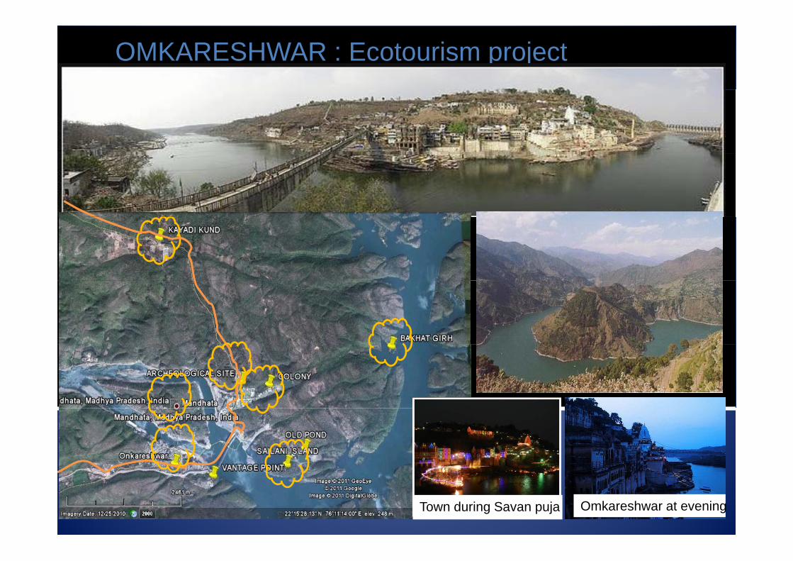
OMKARESHWAR : Ecotourism project
The back view
Omkareshwar at eveningTown during Savan puja

OMKARESHWAR : uniqueness of spot
Bird’s nestBird’s nest

RESORT COMPLEXconcept is reflected in 4 concept is reflected in 4
dimensions- by form/ colour scheme/sound effect/ activity uses
Design Form taken from “ OM “
Use of “chanting OM sound g” as symbol of audio backdrop
Application of the manifestation of three luminaries known as Agni, Vayu and Aditya in design
Harmonic dimensions, colors and textures shall be used to promote emotional, physical, mental and spiritual health
1. Boating 2 R k li bi
spiritual health.
Swimming Pool
2. Rock climbing3. Nature trails & trekking4. Heritage structure visits5. & study6. Birds watching7. Star gazing 8. Educational aspect including
interpretation,9. study and research10 Provide opportunity to have10. Provide opportunity to have
linkage between11. culture and biodiversity12. Village tourism

THANK YOU
100