Embed Size (px)
Citation preview
American Indians: Pre-Colonial5th Grade History Unit
Written By: Jackie FreySST 309-01Winter 2014
1Unit Plan- 5th History SST 309-01 Frey Winter 2014
Table of Contents
1. Overview/Rationale/GLCE
introduction……………………………………………………………………………………………………………. 3
2. KUDs…………………………………………………………………………………………………………………… 4
3. Assesments…………………………………………………………………………………………………………….. 10
4. Lesson Plans
a. Vocabulary Lessons…………………………………………………………………………………………… 13
b. GLCE Lessons………………………………………………………………………………………………….17
5. Resource Attachments…………………………………………………………………………………………………27
6. Works Cited…………………………………………………………………………………………………………….30
2Unit Plan- 5th History SST 309-01 Frey Winter 2014
Introduction/Overview: This unit teaches 5th grade students the historical, cultural, and regional aspects of American Indian life before European colonization. This is done through use of artifact inquiries, video clips, artwork studies, maps, informational texts, tribal legends, historic fiction texts, and group research. Students will demonstrate their understanding through foldables, group work projects, maps, and chart displays of research.
Rationale: It is important for students to learn where American Indian groups lived, how their societies, beliefs, and governmental structures compare and differ, and how they lived in, modified, and adapted to the environment they were in. this is to give students valuable insight into the lives of native peoples in North America and how the differing cultures of American Indians made for conflict with European explores in later units.
GLCE Introduction
This unit uses the following Grade Level Content Expectations for 5th grade History:
5- U1.1.1 Use maps to locate people in the desert Southwest, the Pacific Northwest, the nomadic nations of the Great Plains, and the woodland peoples east of the Mississippi River (Eastern Woodland).
5- U1.1.2 Compare how American Indians in the desert Southwest and the Pacific Northwest adapted to or modified the environment.
5- U1.1.3 Describe Eastern Woodland American Indian life with respect to government and family structure, trade, and views on property ownership and land use.
3Unit Plan- 5th History SST 309-01 Frey Winter 2014
KUDsGLCE (coding and wording) and Verb underlined 5- U1.1.1 Use maps to locate people in the desert Southwest, the Pacific Northwest,
the nomadic nations of the Great Plains, and the woodland peoples east of the Mississippi River (Eastern Woodland). (Skill verbs)
Knowledge (K) Understand (U)
DO:Demonstration of Learning (DOL)
Vocabulary I Can
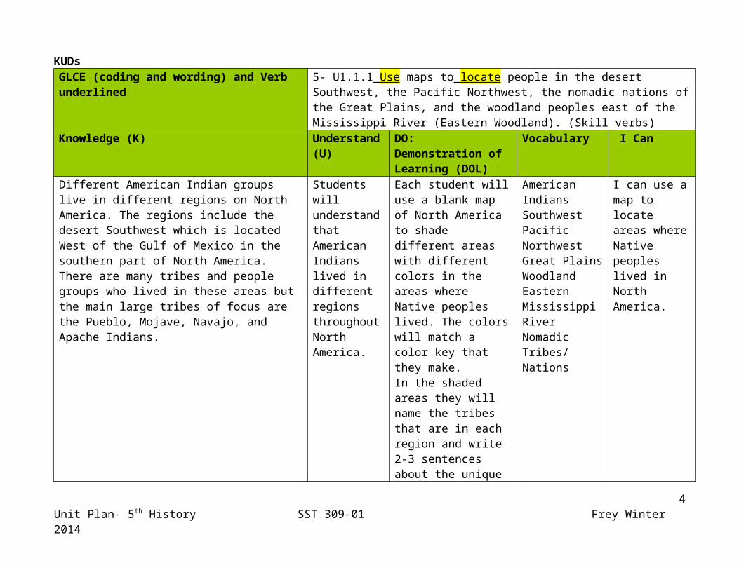
Different American Indian groups live in different regions on North America. The regions include the desert Southwest which is located West of the Gulf of Mexico in the southern part of North America. There are many tribes and people groups who lived in these areas but the main large tribes of focus are the Pueblo, Mojave, Navajo, and Apache Indians.
http://media.web.britannica.com/eb-media/45/132345-004-52189239.gif
Students will understand that American Indians lived in different regions throughout North America.
Each student will use a blank map of North America to shade different areas with different colors in the areas where Native peoples lived. The colors will match a color key that they make. In the shaded areas they will name the tribes that are in each region and write 2-3 sentences about the unique aspects of the peoples in each region.
American IndiansSouthwestPacific NorthwestGreat PlainsWoodland Eastern Mississippi RiverNomadicTribes/Nations
I can use a map to locate areas where Native peoples lived in North America.
4Unit Plan- 5th History SST 309-01 Frey Winter 2014
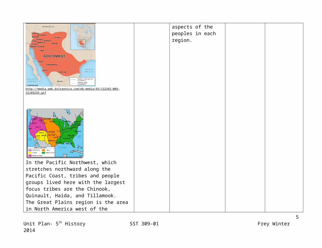
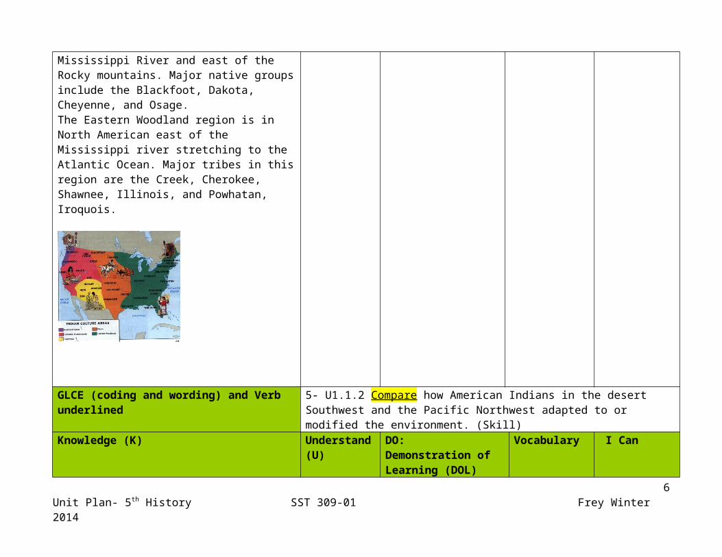
In the Pacific Northwest, which stretches northward along the Pacific Coast, tribes and people groups lived here with the largest focus tribes are the Chinook, Quinault, Haida, and Tillamook.The Great Plains region is the area in North America west of the Mississippi River and east of the Rocky mountains. Major native groups include the Blackfoot, Dakota, Cheyenne, and Osage.The Eastern Woodland region is in North American east of the Mississippi river stretching to the Atlantic Ocean. Major tribes in this region are the Creek, Cherokee, Shawnee, Illinois, and Powhatan, Iroquois.
5Unit Plan- 5th History SST 309-01 Frey Winter 2014
GLCE (coding and wording) and Verb underlined 5- U1.1.2 Compare how American Indians in the desert Southwest and the Pacific Northwest adapted to or modified the environment. (Skill)
Knowledge (K) Understand (U)
DO:Demonstration of Learning (DOL)
Vocabulary I Can
The environment of the Pacific Northwest is of cooler temperature that is of mostly woodlands. The trees in this region gave the peoples in this area building materials to make longhouses where they lived. They also adapted to their environment of coastal by using fishing, whaling, and canoe making to thrive. Using cut trees for lumber, fuel, canoes, and totem poles modified their environment. The slightly cleared forests made room for living conditions, hunting, and agriculture.
The environment of the desert Southwest is a warmer, dry climate or desert which does not give much vegetation. Peoples in this region had to adapt to the environment such as build homes made of adobe clay into pueblos. They had to implement methods of dry farming which included irrigation systems to water crops. Which modified the environment around them
Students will understand that both the American Indians in the desert Southwest and Pacific Northwest adapted to and changed their environment in similar and different ways in order to thrive.
Each student will fill in a chart that compares different aspects of environment and living. They will then write how the people in each region adapted their environment or modified it.
SW NWLiving conditionsFoodAnimalsBuilding materialsagriculture
DesertSouthwest (desert)PacificPacific NorthwestAdaptModifyChangeEnvironmentClimatevegetationLumberhuntingAdobePuebloLonghouseCanoeTotem polesWhalingAgricultureDry farmingcropsIrrigation
I can tell how American Indians in the desert Southwest and the Pacific Northwest adapted to and modified their environments.
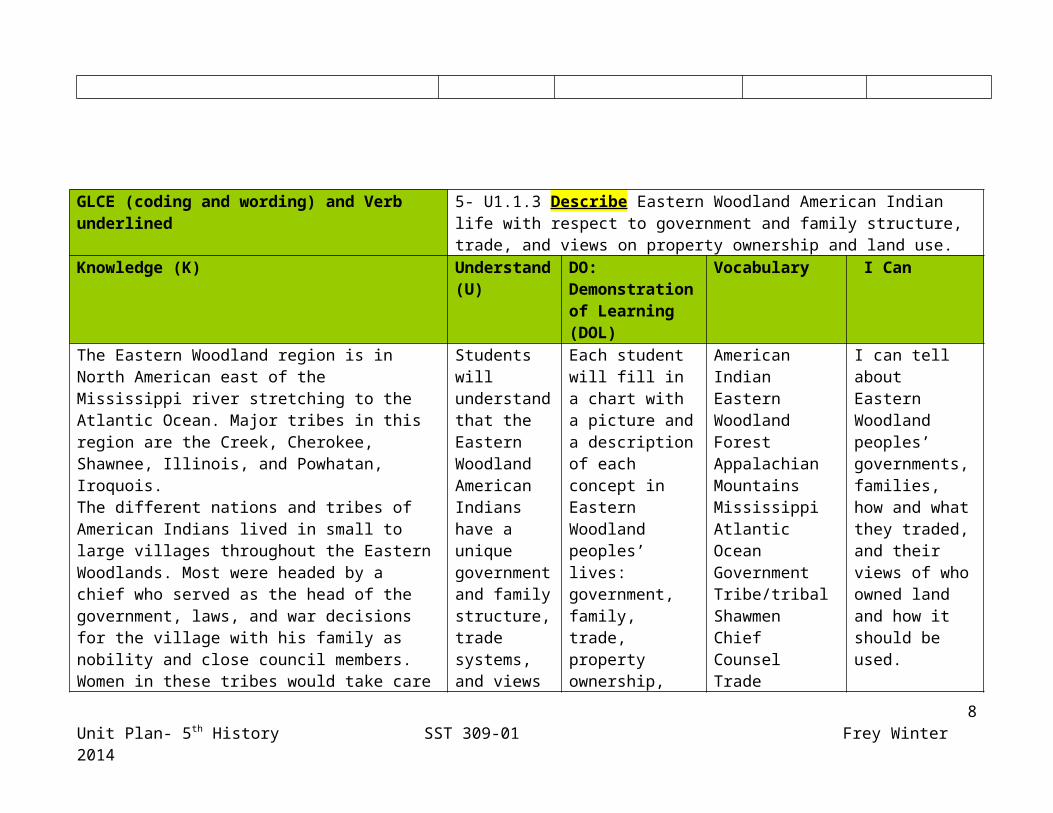
GLCE (coding and wording) and Verb underlined 5- U1.1.3 Describe Eastern Woodland American Indian life with respect to government and family structure, trade, and views on property ownership and
6Unit Plan- 5th History SST 309-01 Frey Winter 2014
land use. Knowledge (K) Understand
(U)DO:Demonstration of Learning (DOL)
Vocabulary I Can
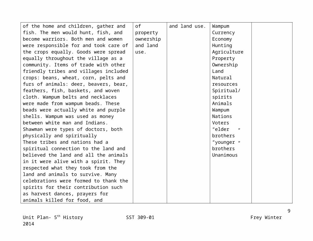
The Eastern Woodland region is in North American east of the Mississippi river stretching to the Atlantic Ocean. Major tribes in this region are the Creek, Cherokee, Shawnee, Illinois, and Powhatan, Iroquois. The different nations and tribes of American Indians lived in small to large villages throughout the Eastern Woodlands. Most were headed by a chief who served as the head of the government, laws, and war decisions for the village with his family as nobility and close council members. Women in these tribes would take care of the home and children, gather and fish. The men would hunt, fish, and become warriors. Both men and women were responsible for and took care of the crops equally. Goods were spread equally throughout the village as a community. Items of trade with other friendly tribes and villages included crops: beans, wheat, corn, pelts and furs of animals: deer, beavers, bear, feathers, fish, baskets, and woven cloth. Wampum belts and necklaces were made from wampum beads. These beads were actually white and purple shells. Wampum was used as money between white man and Indians. Shawman were types of doctors, both physically and spirituallyThese tribes and nations had a spiritual connection to the land and believed the land and all the animals in it were alive with a spirit. They respected what they took from the land and animals to survive. Many celebrations were formed to thank the spirits for their contribution such as harvest dances, prayers for animals killed for food, and dedications to the spirits in their names. Since they
Students will understand that the Eastern Woodland American Indians have a unique government and family structure, trade systems, and views of property ownership and land use.
Each student will fill in a chart with a picture and a description of each concept in Eastern Woodland peoples’ lives: government, family, trade, property ownership, and land use.
American IndianEastern WoodlandForestAppalachian MountainsMississippiAtlantic OceanGovernmentTribe/tribalShawmenChiefCounselTradeWampumCurrencyEconomyHuntingAgriculturePropertyOwnershipLandNatural resourcesSpiritual/spiritsAnimalsWampumNationsVoters“elder brothers”“younger brothers”Unanimous
I can tell about Eastern Woodland peoples’ governments, families, how and what they traded, and their views of who owned land and how it should be used.
7Unit Plan- 5th History SST 309-01 Frey Winter 2014
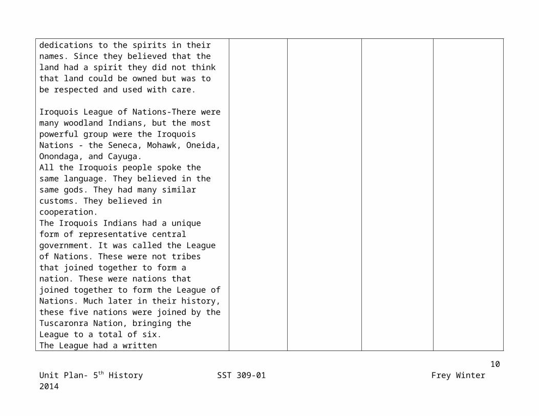
believed that the land had a spirit they did not think that land could be owned but was to be respected and used with care.
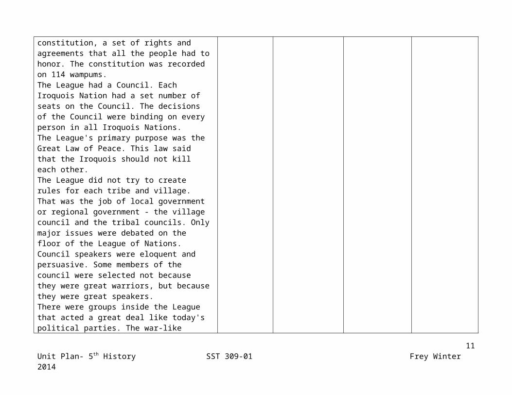
Iroquois League of Nations-There were many woodland Indians, but the most powerful group were the Iroquois Nations - the Seneca, Mohawk, Oneida, Onondaga, and Cayuga. All the Iroquois people spoke the same language. They believed in the same gods. They had many similar customs. They believed in cooperation. The Iroquois Indians had a unique form of representative central government. It was called the League of Nations. These were not tribes that joined together to form a nation. These were nations that joined together to form the League of Nations. Much later in their history, these five nations were joined by the Tuscaronra Nation, bringing the League to a total of six. The League had a written constitution, a set of rights and agreements that all the people had to honor. The constitution was recorded on 114 wampums. The League had a Council. Each Iroquois Nation had a set number of seats on the Council. The decisions of the Council were binding on every person in all Iroquois Nations. The League's primary purpose was the Great Law of Peace. This law said that the Iroquois should not kill each other. The League did not try to create rules for each tribe and village. That was the job of local government or regional government - the village council and the tribal councils. Only major issues were debated on the floor of the League of Nations. Council speakers were eloquent and persuasive. Some members of the council were selected not because they
8Unit Plan- 5th History SST 309-01 Frey Winter 2014
were great warriors, but because they were great speakers. There were groups inside the League that acted a great deal like today's political parties. The war-like Mohawk and Oneida often teamed up in the debates. The peaceful Seneca and Cayuga speakers would team up to oppose them. Fortunately, one of the League's constitutional rules was that the Chief of the League would always be selected from the Onondaga Nation. The peace loving Onondaga held 14 seats in the council. That was a lot of seats. The Onondaga were able to keep peace simply by reminding all representatives that their block of votes could swing either way. Although each member's vote carried the same weight, there was a pecking order. The Mohawk, Onondaga, and Seneca were addressed as "elder brothers" and the Oneida, Cayuga, and Tuscarora were addressed as "younger brothers". If there was a weakness to this system, it was that all decisions had to be unanimous. By the 1600's, the Iroquois knew it was essential to present a united front to the colonists. Debates, although heated, nearly always led to a unanimous decision. The Nations stood together, and that made them strong. When the early colonists began to design a system of government for what would become the United States of America, they borrowed many ideas from the League of Nations. It worked for Iroquois, and it worked for the new American government. The League of Nations government is still used today.
9Unit Plan- 5th History SST 309-01 Frey Winter 2014
Assessment ideas: Assessment 1- During the unit students will participate in research on different tribes in the Pacific Northwest, Desert Southwest, and the Eastern Woodland. During their research they will complete charts for each of their tribes as shown in Attachment A.
Assessment 1- RubricStudent Name: ________________________________________
CATEGORY 10 8 5 1Content Each category is fully
developed. The descriptions and information are all accurate. There is more than one example in each category.
Each category is mostly developed. The descriptions and information are mostly accurate. There is at least one example for each category.
Every category is not developed. The descriptions are not accurate or do not make sense. There are not examples for every category.
Almost none of the categories are developed. There are no descriptions or no factual information. There are no examples.
Grammar & Spelling (Conventions)
Writer makes no errors in grammar or spelling that distract the reader from the content. All responses are in complete sentences.
Writer makes 1-2 errors in grammar or spelling that distract the reader from the content. All responses are in complete sentences.
Writer makes 3-4 errors in grammar or spelling that distract the reader from the content. Most responses are in complete sentences
Writer makes more than 4 errors in grammar or spelling that distract the reader from the content. No responses are in complete sentences.
Accuracy of Facts (Content)
All supportive facts are reported accurately.
Almost all supportive facts are reported accurately.
Most supportive facts are reported accurately.
NO facts are reported OR most are inaccurately reported.
Focus on Topic (Content)
There is one clear, well-focused topic. Main idea stands out and is supported by detailed information.
Main idea is clear but the supporting information is general.
Main idea is somewhat clear but there is a need for more supporting information.
The main idea is not clear. There is a seemingly random collection of information.
10Unit Plan- 5th History SST 309-01 Frey Winter 2014
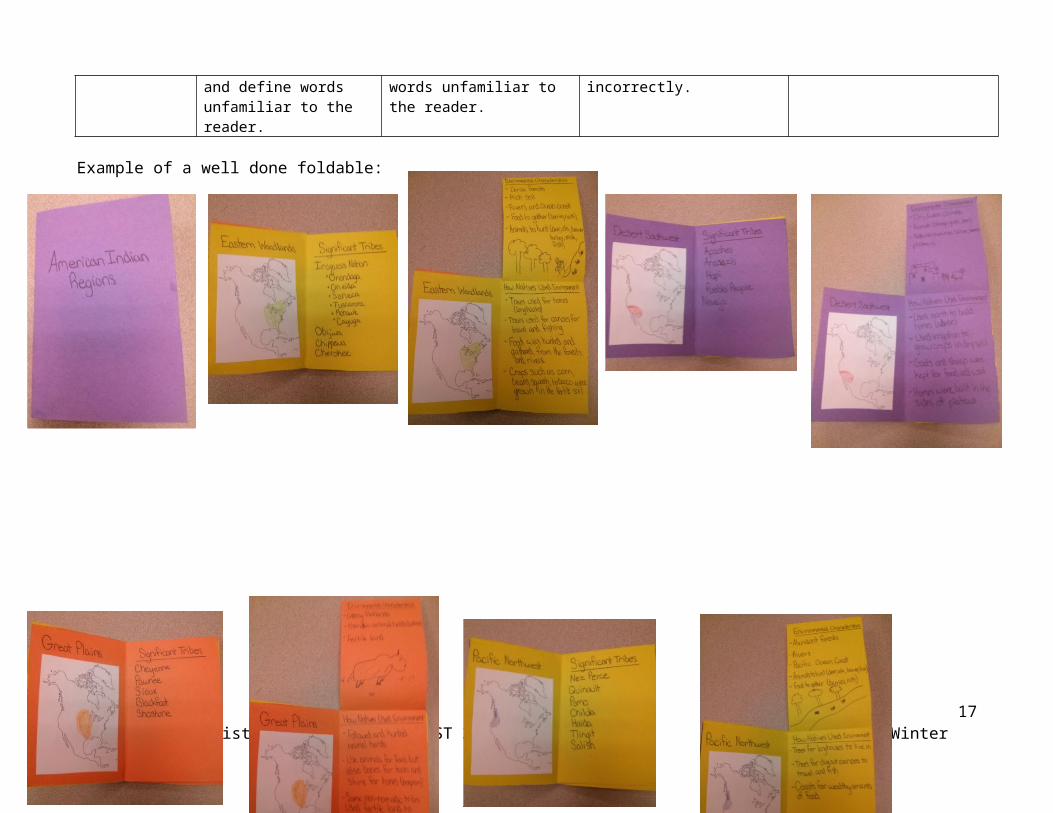
Assessment 2- Students will demonstrate all that they have learned by completing a single flap expandable booklet foldable. There should be one section for each of the American Indian cultural regions with each section including the name of the region, map of the region, notable tribes/nations that lived in the region, physical characteristics of the environment, and how the natives used these resources.
Assessment 2- Rubric
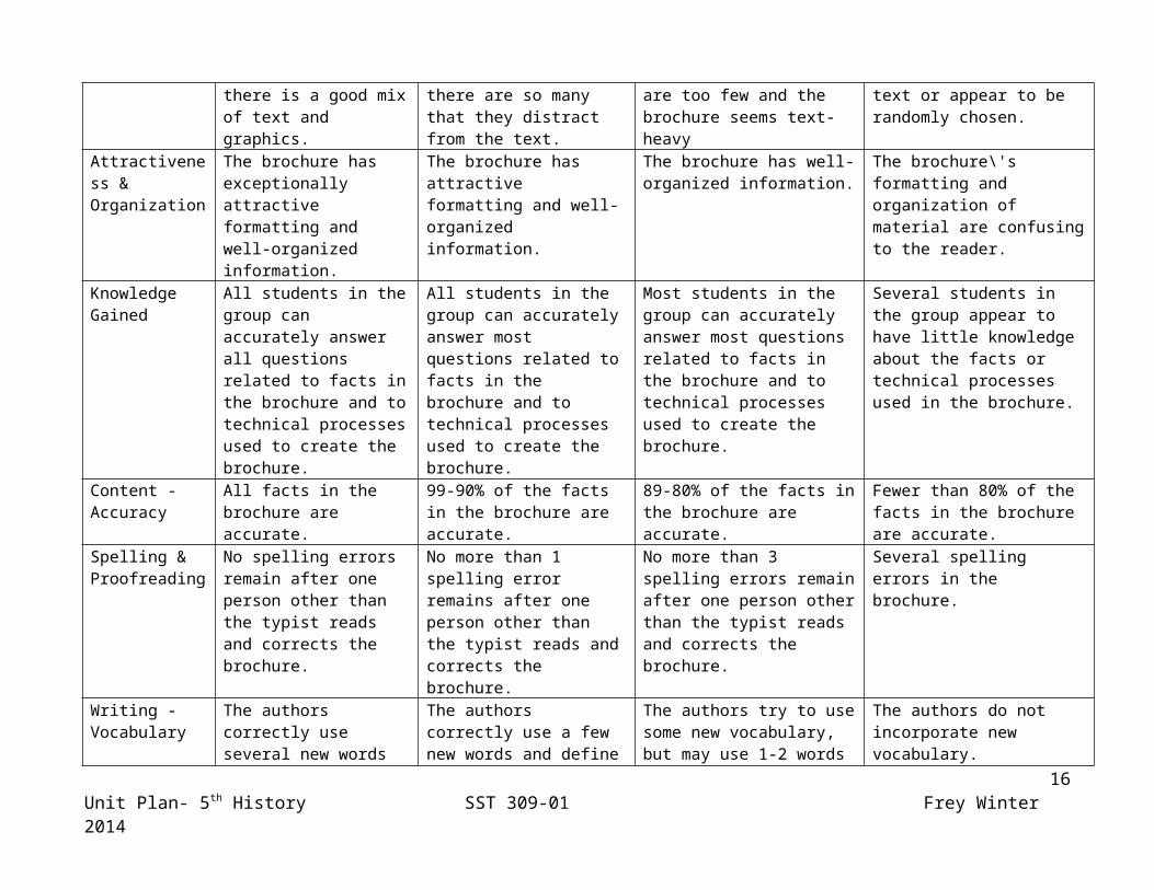
CATEGORY 10 8 5 1Graphics/Pictures Graphics go well with the
text and there is a good mix of text and graphics.
Graphics go well with the text, but there are so many that they distract from the text.
Graphics go well with the text, but there are too few and the brochure seems text-heavy
Graphics do not go with the accompanying text or appear to be randomly chosen.
Attractiveness & Organization
The brochure has exceptionally attractive formatting and well-organized information.
The brochure has attractive formatting and well-organized information.
The brochure has well-organized information.
The brochure\'s formatting and organization of material are confusing to the reader.
Knowledge Gained
All students in the group can accurately answer all questions related to facts in the brochure and to technical processes used to create the brochure.
All students in the group can accurately answer most questions related to facts in the brochure and to technical processes used to create the brochure.
Most students in the group can accurately answer most questions related to facts in the brochure and to technical processes used to create the brochure.
Several students in the group appear to have little knowledge about the facts or technical processes used in the brochure.
Content - Accuracy
All facts in the brochure are accurate.
99-90% of the facts in the brochure are accurate.
89-80% of the facts in the brochure are accurate.
Fewer than 80% of the facts in the brochure are accurate.
Spelling & Proofreading
No spelling errors remain after one person other than the typist reads and corrects the brochure.
No more than 1 spelling error remains after one person other than the typist reads and corrects the brochure.
No more than 3 spelling errors remain after one person other than the typist reads and corrects the brochure.
Several spelling errors in the brochure.
Writing - Vocabulary
The authors correctly use several new words and define words unfamiliar to the reader.
The authors correctly use a few new words and define words unfamiliar to the reader.
The authors try to use some new vocabulary, but may use 1-2 words incorrectly.
The authors do not incorporate new vocabulary.
11Unit Plan- 5th History SST 309-01 Frey Winter 2014
Example of a well done foldable:
Vocabulary Lesson
12Unit Plan- 5th History SST 309-01 Frey Winter 2014
Lessons: How will you take them where they need to go?
Instructional strategies/Social constructs: How will they work?
Resources needed: What materials and resources will they need?
Vocabulary Lesson- American Indian RegionsPre-test/Anticipatory set: Teacher will ask students how the United States is broken up currently.
Create a list until it includes at least: states, cities, and physical regions
Ask students how living in different regions can make a difference between what resources you have.Lesson:This lesson will follow Marzano’s Six Steps for vocabulary instruction. Step One:Introduce the regions of North America in relation to where American Indians lived prior to European Civilization. (Desert Southwest, Pacific Northwest, Great Plains, Eastern Woodland)Use cardinal directions to describe the location of the regions.Use a map of North America to point to or highlight each region as they are discussed.Use land formations to explain general boundaries of each region without using modern day boundaries such as state lines.Use physical characteristics of each region to describe the locations of the regions.Use the First American’s power point to walk students through the information.
We have learned how North America and
Instructional strategies/Social constructs:
Resources needed: What materials and resources will they need ? (also included on Works Cited page)
13Unit Plan- 5th History SST 309-01 Frey Winter 2014
The United States identify different regions in ways such as cities and states. Before Europeans colonized North American people were already living here, they are called American Indians. The places where the American Indians lived are divided into different regions.The Pacific Northwest is a region where American Indians lived on the western coast of North America (point to map) in the northern part as suggested by its name. The region stretched from the Pacific Ocean Coast to approximately the western edge of the Rocky Mountains and from the Umpaqua River north to the northern part of the large island off the coast from mainland.This area was full of woods and streams. The people who lived in this region were very rich with food because the area had lots of hunting with elk and deer, fishing along the coast and rivers, and wild berries to gather.
Another region where American Indians lived was the Desert Southwest. This region stretched from the southern Pacific coast to eastern edge of the Rocky Mountains. It is from Lake Mead to the Northern end of the Gulf of California. This area was dry desert areas. The people who lived in this region used the earth as shelter in homes made of Adobe. Food came from farming which was made possible in the dry climate from irrigation.
Use a map of North America to show students regions
The First American Power point
14Unit Plan- 5th History SST 309-01 Frey Winter 2014
A large region where American Indians lived was the Great Plains. This region was in central North America stretching from the Northern edge of the Gulf of Mexico to the Northern edge of Lake Superior. It also spread from the Eastern edge of the Rocky Mountains to the Mississippi River. The land in this area is very flat and grassy. Animals roam in herds. The people in this area were nomads, following the animal herds hunting them for food.The final American Indian region is the Eastern Woodland region. This is the area of North America East of the Mississippi River and from the southern edge of Florida to the Gulf of St. Lawrence. In this large region there is much woodland and forest areas along with a lot of fertile ground. The people in this region would hunt in the forests animals such as deer, beavers, and turkey. They would also fish in the rivers, along the Atlantic coast, and would grow crops such as corn, beans, and squash. These three crops are known as the Three Sisters.
Step Two:Guided Practice-Students will participate in a Think-Pair-Share. Prompt: Think of different ways in which you can describe each of the regions where American Indians lived.
Use First American’s power point to walk students through information
Think, Pair, Share
15Unit Plan- 5th History SST 309-01 Frey Winter 2014
Step Three:Independent practice-Students will get a blank map of North America. They will need to mark the different regions of American Indians.
Step Four:Group practice-Students will be split into four groups, one for each region. The students will then write characteristics that they feel are important about each of the regions.
Step Five:The groups will then present to the class the information they find important. The other groups are encouraged to ask questions such as clarification, reasoning, or to add their own ideas.
Step Six:Students will play a modified BINGO game. Students will take a 5x5 BINGO board and write each of the 4 regions 6 times on the board. The teacher will pick characteristics, descriptions, living styles, physical characteristics of each of the regions until there are winners.
Independent visual practice
Group discussion
Classroom Discussion
Definition BINGO game
Blank North American map, markers, colored pencils, crayons.
Notebooks to write notes.Large poster board for student to write characteristics to use in presentation
Paper for students to make their own BINGO boards
Lessons: How will you take them Instructional strategies/Social Resources needed: What materials and
16Unit Plan- 5th History SST 309-01 Frey Winter 2014
where they need to go? constructs: How will they work? resources will they need?
Lessons:
Anticipatory Set:Students will watch the American Indians Smart Song Rap. They will be asked to focus on the regions and the different characteristics that are mentioned in the song.
Lessons (Eastern Woodland):
Eastern Woodland: Food/Land
1. Display pictures of local geographical regions (Michigan: hill country, farmland, forests) and display pictures of food typical of your region (Michigan: corn, cherries, apples, blueberries). Discuss how a region's food is connected with the natural resources, climate, and location. For example: apples are a profitable crop in Michigan.2. Through discussion tie in the fact that the location of each Native American tribe settlement affected the food sources available to the tribes. 3. Explain to the class that they will be divided into small groups to research and become “experts” on a particular Eastern Woodland Indian tribe. Assign small cooperative groups of 3 to 4 students each. Each group will be assigned a tribe from the
Video clip
Lesson pictorial introduction
Small group work
http://www.youtube.com/watch?v=VDzfW9rHiQw
Images of Michigan geographical regions
17Unit Plan- 5th History SST 309-01 Frey Winter 2014
following list: * Cherokee Confederacy * Susquehanna * Seminole * Mohican * Powhatan * Massachusett * Iroquois Confederacy * Delaware 4. After assigning each group a tribe, introduce the graphic organizer and explain that this is where they will write all the information found while researching. On chart paper have a blown-up version of the graphic organizer posted in your room and explain that as students research they may add questions or research ideas that pertain to each given area. Teacher should model this by adding “Were they hunters, gatherers, or framers?” to the first column. Explain that each group will locate the geographic location and the common foods of their tribe. This information will be entered as a part of their on going research project onto their graphic organizer about their own tribe. 5. Explain that at the end of their research, they will present all the information accumulated during the unit, to the class in a format of their choice. (Interview, skit, written report, oral report, poster, mural, diorama, newspaper, etc.) These should last about 5 to 10 minutes. 6. Students begin to research and work on their projects using the classroom library and online resources, while the teacher circulates amongst the groups. Teachers can direct each group to appropriate sources available.
Graphic organizer
Graphic Organizers- Attachment A
Trade Books for research:Scholastic Encyclopedia of the North American
18Unit Plan- 5th History SST 309-01 Frey Winter 2014
Eastern Woodland- Living/Homes
1. Display pictures of local styles of architecture or of homes native to your area. Discuss how regional buildings are made out of materials that are locally and readily available. 2. Discuss why readily available materials are chosen to use in construction of buildings. 3. Discuss the student responses on types of Native American homes they already know about. What kinds of resources did they use to build them and why? 4. Explain that today each group will be researching their own tribes to locate the buildings and resources, which their tribes used. 5. Students break up into their cooperative groups to research and work on their projects, while the teacher is available for consultation, to assist the students in locating their needed information from the resources available.
Eastern Woodland- Family Roles
Divide the class into thirds. Assign 1/3 to find pictures that illustrate the role of men, 1/3 that illustrate the role of women, and 1/3 that illustrate the role of children in our society.
Indian- Ciment, J.&LaFrance, R.The Cherokee Indians. Covert, N. The Cherokee Indians- Claro, N.The Mohawk- Duvall, J.Brother Eagle, Sister Sky- Jeffers, S. The Cherokees- Landau, E. The Cherokee- Lepthien, E.The Cherokee- McCall, B. The Iroquois- McCall, B. The Delaware- Miller, J. Indians of the Northeast Woodlands- Siegel, B.The Cherokees- Sneve, V. The Iroquois- Sneve, V. The Seminoles- Sneve, V.Indians of the Northeast- Colin Calloway
Websites for research:http://nativeamericans.mrdonn.org/northeast.html
http://www.davemcgary.com/northeast-native-american-tribes.htm
http://www.native-languages.org/northeast-culture.htm
http://www.snowwowl.com/maps/mapnortheast.html
http://nmai.si.edu/sites/1/files/pdf/education/HaudenosauneeGuide.pdf
19Unit Plan- 5th History SST 309-01 Frey Winter 2014
2. Pass out magazines, construction paper, and glue to each group. Allow them to cut and paste pictures they find for about 8-10 minutes. Have each group present their posters and lead the class in a discussion of the roles of our society. Discuss how the traditions of a society help shape the roles that individuals play within their families and communities. 3. Explain that today each group will be researching their own tribe to locate the roles men, women, and children played within their culture. 4. Students break up into their cooperative groups to research and work on their projects, while the teacher is available to direct research inquiries.
Eastern Woodland- Government:1. Discuss why we have the type of government we have today. Ask the class, “From your research so far, what type of government do you think your tribe has and how was this decided?” Have class members discuss in their cooperative groups and then share with the whole class. 2. Dismiss the class into their cooperative groups to research and identify the type of tribal government used by their tribe. The teacher is monitoring group work and assisting when needed.
20Unit Plan- 5th History SST 309-01 Frey Winter 2014
Eastern Woodland- Religion
Anticipatory Set:Teacher will hook students into lessons about American Indians in the Eastern Woodlands by showing a video of Disney’s Pocahontas song “Colors of the Wind”
1. Divide the class into their cooperative research groups. Have them brain storm the meaning of religion and a list of things they value. 2. Have a whole class discussion with small groups contributing there group ideas. Record their ideas on chart paper. Discuss and compile a definition that the class can agree upon. 3. Looking at the classroom definition of religion ask the question: “How are your values connected to your religious beliefs?” Teacher leads the discussion by modeling personal example. 4. Read the class Brother Eagle, Sister Sky by Susan Jeffries. Discuss the connections between spiritual beliefs and values using examples from the book. Discuss these questions: How was the Native American outlook on religious and spiritual beliefs different from ours? In what ways? Why do you think this is? (Be sure to mention to the class that Native American beliefs held that spirits inhabits all inanimate aspects of the physical world, i.e. sky, sun, earth, water,.) 5. Focus the class’ attention on the questions
Music Video hook
Colors of the Wind-Disneyhttp://www.youtube.com/watch?v=TkV-of_eN2w
Brother Eagle, Sister Sky by Susan Jeffries
21Unit Plan- 5th History SST 309-01 Frey Winter 2014
from their research graphic organizer on today’s topic, before having them begin their research on their tribes’ spiritual beliefs and values. 6. Cooperative groups begin working on their research and projects, while the teacher works with individual groups who need assistance.
Lessons (North West/South West):
North West- Before the White Man Came1. Hand out article "Before the White Men Came to Nisqually Country," and have students take time to read through the article on their own (approx. 5-8 minutes)2. After reading the articles have students participate in a Think, Pair, Share to discuss what they learned from the article or what they found interesting. Students will think about the question: “Based on this article, how did tribes in the Pacific Northwest use their environment and the resources around them? List examples from the text that include: living, shelter, food, family.” 3. After students have had time to discuss with a partner they will then be broken up into four groups. They will use either use poster paper or the white board to list ways that natives used their environment: one group for each of the categories- living, shelter, food, and family.4. Groups will then share their findings with the entire class, discussion will then continue after to add to or alter topics on
Think, Pair, Share
Group work/presentation
Class discussion
“Before the White Man Came to Nisqually Country” By Carpenter
Paper, markers, crayons
22Unit Plan- 5th History SST 309-01 Frey Winter 2014
each list.
North West- Totem Poles
1. Show students slides and photos of American Indian totem poles. Have students discuss as a class descriptions of what they see. As a class, we will describe and list all the physical characteristics such as height, approximate weight, materials, and construction. These descriptions must be restricted to what the students can observe in the object itself. They can use descriptions of color, light, and texture.
Lesson II
1. Have students review the posters of environmental resources the American Indians used that they made in the previous lesson. Talk about the rich variety of plant and animal life, the jungle-like forests of trees, the abundance of fish, fowl and game. 2. Encourage students to imagine what this area might look like and what it would be like to live there. Using just one period have the students draw with crayon or cut pictures from magazines to make a collage of what they imagine this birthplace of the totem pole to be like.
Desert Southwest:
Artistic representation of environment
Books with Totem Pole Images:
The Wolf and the Raven, Garfield.Totem Poles, Totem Poles According to Crests and Topics, Barbeau.Monuments in Cedar, Keithahn.
Paper, crayons, colored pencils, scissors, magazines, glue
23Unit Plan- 5th History SST 309-01 Frey Winter 2014
1. Show students an image of southwest Indians’ homes. Have them do a 5x5 in which they make five comments or observations and then write five questions that they have about the picture.
1. Read the book: Turquoise Boy by Cohlene aloud to the class.2. Have students make a map on Navaho life including a key showing drawings of types of homes they lived in and the food they ate. Sing the Navaho Beauty Song. Desert Southwest: Clothing
1. Begin with showing students examples of native peoples wearing clothing from the desert Southwest and examples of woven rugs. Have students make predictions about where they think the tribes that wear these types of clothing lived and why.
2. Show students the cover of the story, “The Goat in the Rug.” I will explain that this story is about a Navajo Indian and her goat. Read the story aloud to the class.3. After reading the story students will write a RAFT reflection. R-Geraldine A- villagers F- advertisement/billboard T- an advertisement to sell your rug, why is it meaningful, how it was made
5x5 picture analysis
Read aloud and map making
RAFT writing strategy
Salinas Pueblo Missions National Monument image Attachment C.
Turquoise Boy by Cohlene
The Goat in the Rug by Charles Blood
Paper, pencils, crayons, markers
24Unit Plan- 5th History SST 309-01 Frey Winter 2014
North/South West- Comparison
Tribal Charts
1. Students will be assigned tribes from the Southwest and the Northwest. They will again fill out tribal charts based on research they have done.
1. Students will divide into two groups. One will be assigned to the Pacific Northwest and the other to the Desert Southwest. Each group will take their research from previous lessons and make a chart of characteristics that are specific to their region. Topics must include: food, shelter, resources, and environment.2. After discussion the groups will then
research
Group discussion
Class discussion
Attachment A
Books for research:The Chippewa- Jacqueline GreeneThe Hopi- Elaine LandauThe Nez Perce- Madelyn AndersonThe Pawnee- Arthur MyersThe Pomo- Elaine LandauHistory of US, The First Americans- Joy HakimIndians of the Southwest- Karen Liptak The Earliest American- Helen SattlerUSKids History: Book of the American Indians- Marlene Smith-Baranzini North American Indian Survival Skills- Karen Liptak Indians of the Pacific Northwest- Karen LiptakWebsites:http://nativeamericans.mrdonn.org/ http://www.native-languages.org/kids.htm
Attachment D.
25Unit Plan- 5th History SST 309-01 Frey Winter 2014
present their findings.3. As a class, make a list of characteristics that were the same between the regions.4. Students will then write a reflection about the similarities and differences in the characteristics between the two American Indian cultural regions with respect to how their environment and resources affected them.
American Indian Regions
Students will demonstrate all that they have learned by completing a single flap expandable booklet foldable. There should be one section for each of the American Indian cultural regions with each section including the name of the region, map of the region, notable tribes/nations that lived in the region, physical characteristics of the environment, and how the natives used these resources.
Self student reflection for assessment
Foldables
Colorful construction paper, pens, pencils, glue, crayons, markers, colored pencils, scissors.
Attachment F.
26Unit Plan- 5th History SST 309-01 Frey Winter 2014
Resource Attachments
A.Tribe Name
What types of foods did your tribe commonly eat? How were the foods prepared? What types of buildings, homes, or shelters did your tribe build? What materials did they use?What was the role of men, women, and children in your tribe?How did your tribe rule itself? What was the leader called and what was his job? What were their religious beliefs? What were their feelings about nature? What personal characteristics did they think were important? What kinds of tools were used in their daily life? How were they made? What famous crafts was your tribe known for making? What roles do tribe members play in society today? What is one interesting fact that you learned about your tribe in modern times?
27Unit Plan- 5th History SST 309-01 Frey Winter 2014
B. Articlehttp://washingtonhistoryonline.org/treatytrail/teaching/before-white-man.pdf
C.
D. South West North West
Living conditions
Food
Animals
Building materialsAgriculture
28Unit Plan- 5th History SST 309-01 Frey Winter 2014
E.Government Structure Trade
Draw a picture that describes the government system
Write about what you drew (caption)
Draw a picture that describes the government system
Write about what you drew (caption)
Write 3-4 sentences describing the government structure. Be sure to include who made the rules, who was in charge, and why.
Write 3-4 sentences describing the trade system. Be sure to include types of traded goods/services, types of trade, and currency.
F.
29Unit Plan- 5th History SST 309-01 Frey Winter 2014
Works Cited
American Indians in Olden Times. The First Americans- Power Point, http://nativeamericans.mrdonn.org/powerpoints/overviews.html
Basti, M. K. (2014) Totem Poles of the North American Northwest Coast Indians, http://www.yale.edu/ynhti/curriculum/units/1985/6/85.06.01.x.html#b
Dalke, J. (2012) Navajo Indians, http://lessonplanspage.com/sslaartnativenavajo-culture35-htm/
Donn, L. (2008) Northeast Iroquois Nation League of Nations, http://nativeamericans.mrdonn.org/northeast/iroquois/leagueofnations.html
Enchanted Learning (2009) Outline Map of North America, http://www.enchantedlearning.com/geography/namer/outlinemap/
Hertzig, D. (2001) Becoming an Expert on Eastern Woodland Indians,http://www.coreknowledge.org/mimik/mimik uploads/lesson_plans/340/Becoming%20an%20Expert%20on%20Eastern%20Woodland%20Indians.pdf
National Parks Services (2011) Gran Quivira: A Blending of Cultures in a Pueblo Indian Village, http://www.cr.nps.gov/nr/twhp/wwwlps/lessons/66gran/66gran.htm
Native Languages of America (2014) Native American Facts For Kids, http://www.native-languages.org/kids.htm
Rubric Star (2014) Rubric Star, http://rubistar.4teachers.org/
Smart Songs (Free, Jeff & Free, Scott) (2012) American Indian Rap- Smart Songs, http://www.youtube.com/watch?v=VDzfW9rHiQw
Washington State Historic Mueseum (2007) A Treaty Trail Lesson Plan, http://www.washingtonhistory.org/files/library/BeforeTheWhiteManCame.pdf
30Unit Plan- 5th History SST 309-01 Frey Winter 2014