Embed Size (px)
Citation preview

殷跃平 主编
Editor-in-Chief Yin Yueping
中国大地出版社C h i n a L a n d P r e s s
图书在版编目(CIP)数据
内 容 提 要
《中国典型滑坡》是一本以照片形式反映我国典型滑坡的画册,包括了顺层滑坡、第三系泥岩滑坡与崩塌、黄土滑坡、风化
层与堆积层滑坡、地震与冰雪型滑坡及堰塞湖、水库滑坡、矿山滑坡与崩塌、城市与道路建设滑坡等8大滑坡类型。通过精选照
片的展示形式,以简要文字阐述了它们所处地理位置、地质环境、形态结构特征、稳定性、灾害程度以及防治工程等内容。本画
册收录了近年来我国发生的非常具有典型意义的滑坡,例如西藏易贡滑坡(2000)、湖北秭归千将坪滑坡(2003)、四川宣汉天台乡
滑坡(2005)、青海阿尼玛卿山滑坡(2005)等。本画册也收录了我国历史上非常著名的滑坡,例如陕西西安翠花山滑坡(公元前780)、
重庆黔江小南海滑坡(1856)、宁夏海原地震滑坡(1920)、四川岷江叠溪滑坡(1933)等。针对三峡库区移民迁建工程的地质灾害防
治,本画册还收录了大量的滑坡及防治工程实例,并提供了若干利用滑坡体综合整治与土地利用的实例。
本画册可供从事地质灾害研究和地质、地震、水电、公路、铁路、矿山、国防工程的生产、科研人员以及有关院校师生参考。
责任编辑:程 新
出版发行:中国大地出版社
社址邮编:北京市海淀区学院路 31号 100083
电 话:010-82329127(发行部) 010-82329007(编辑部)
传 真:010-82329024
网 址:www.chinalandpress.com或www.中国大地出版社.中国
电子邮箱:[email protected]
印 刷:北京纪元彩艺印刷有限公司
开 本:889mm×1194mm 1/16
印 张:
字 数: 千字
版 次:2007年 月第1版
印 次:2007年 月第1次印刷
印 数: 册
书 号:ISBN 978-7-80246-
定 价: 元
版权所有·侵权必究

《《《《《中国典型滑坡》》》》》
编委会
Editorial Committee of“Landslides in China-Selected Case
Studies”
顾问:王思敬 钱七虎 卢耀如 张在明 陈祖煜 李焯芬
主编:殷跃平
编委:(按姓氏笔画排列)
马惠民 王治华 王洲平 王恭先 王润福 宁社教 田大佑 任 坚
刘文龙 刘红星 江鸿彬 吴玮江 何永金 何晓明 余志山 张 黎
张开军 张作辰 张茂省 张保军 李小林 李从仁 李长辉 李晓春
杨胜元 杨顺泉 陈红旗 范相德 尚岳全 郑万模 姜育成 宫小平
赵 成 赵松江 索传眉 唐辉明 卿三惠 徐志文 黄润秋 巢志众
彭光泽 彭轩明 彭建兵 程国明 程谦恭 鄢 毅 黎志恒 魏伦武
Editorial Committee in “Landslides in China-Selected Case Studies”
Technical Consultants:
Wang Sijing Qian Qihu Lu Yaoru Zhang Zaiming Chen Zuyu C. F. Lee
Editor-in-Chief: Yin Yueping
Editors:Ma Huimin Wang Zhihua Wang Zhouping Wang Gongxian Wang Runfu Ning Shejiao
Tian Dayou Ren Jian Liu Wenlong Liu Hongxing Jiang Hongbin Wu Weijiang
He Yongjin He Xiaoming Yu Zhishan Zhang Li Zhang Kaijun Zhang Zuochen
Zhang Maosheng Zhang Baojun Li Xiaolin Li Congren Li Changhui Li Xiaochun
Yang Shengyuan Yang Shunquan Chen Hongqi Fan Xiangde Shang Yuequan Zheng Wanmo
Jiang Yucheng Gong Xiaoping Zhao Cheng Zhao Songjiang Suo Chuanmei Tang Huiming
Qing Sanhui Xu Zhiwen Huang Runqiu Chao Zhizhong Peng Guangze Peng Xuanming
Peng Jianbing Cheng Guoming Cheng Qiangong Yan Yi Li Zhiheng Wei Lunwu

目 录
CONTENTS
前 言 Preface
1 顺层滑坡 Landslides on Dipping Beds
2 第三系泥岩滑坡与崩塌 Mudslides and Falls in Tertiary Materials
3 黄土滑坡 Landslides in Loess
4 风化层与堆积层滑坡 Landslides in Weathered and Colluvial Materials
5 地震与冰雪型滑坡及堰塞湖 Avalaches and Damming Induced by Earthquake and Snowmelt
6 水库滑坡 Landslides Induced by Reservoir Filling
7 矿山滑坡与崩塌 Landslides and Rockfalls Induced by Mining
8 城市建筑和道路滑坡 Landslides Induced by Urban Development and Highway
1
18
27
70
85
120
141
159

由国际土木工程学会土力学与岩土工程分会、国际岩石力学与工程学会和国际工程地质与环境协会联合主办的第10
届国际滑坡与工程边坡会议于2008年 6月 30日至7月4日在西安举办。这次会议是全球滑坡和工程边坡学术界的一次
盛会。应大会组委会主席陈祖煜教授之约,由我主持编著《中国典型滑坡》画册,用图片方式向世界展示我国典型的滑
坡特征。
2004年,当陈祖煜院士告诉我要出版此画册的想法时,我原本以为这是一件难度不大的事。因为,国土资源部开展
了全国1500多个山区丘陵县、市的地质灾害调查,我和我的同事们也长期从事全国范围的滑坡调查、勘察、防治与研究,
手中握有大量的资料。但是,实践起来后方感难度颇大。我国的滑坡类型繁多,千差万别,如何通过这一画册向世界同
行展示,争论激烈。最后,吸收了Varnes 对滑坡的广义分类方案,并结合我国的滑坡分类习惯,不强调学科分类的完
整和严谨,也不刻意追求画面的艺术效果,而是从专家的视角,利用手中的普通相机,呈现我国典型的滑坡形态特征,
并力求从滑坡结构、灾害及防治等角度加以充实。
《中国典型滑坡》画册按照顺层滑坡、第三系泥岩滑坡与崩塌、黄土滑坡、风化层与堆积层滑坡、地震与冰雪型滑
坡及堰塞湖、水库滑坡、矿山滑坡与崩塌、城市建筑和道路滑坡等8种类型,通过精选照片的展示形式,以简要文字阐
述了它们所处地理位置、地质环境、形态、结构特征、稳定性、灾害程度以及防治工程等内容。本画册收录了近几年来
我国发生的非常具有典型意义的滑坡,例如西藏易贡滑坡(2000)、湖北秭归千将坪滑坡(2003)、四川宣汉天台乡滑坡
(2004)等一系列滑坡,也收录了我国历史上非常著名的滑坡,例如四川岷江叠溪滑坡(1933)、重庆黔江小南海滑坡(1856)
等。针对三峡库区移民迁建工程的地质灾害防治,本画册还收录了大量的滑坡及防治工程实例,并提供了若干利用滑坡
体综合整治与土地利用的资料。
《中国典型滑坡》画册终于出版了。感谢编著组的同事们,为了获取滑坡的资料付出了非常艰辛的努力。几乎每一
张图片背后都有非常动人的故事。编著组强调画册不是简单的照片罗列,因此在本画册编著过程中专门考察了大多数滑
坡,提供了大量第一手资料。例如,西藏、青海地质环境监测站等单位的专家多次深入氧气稀少、交通不便的高寒地区,
获取了不同时期的第一手资料。
感谢全国的同行们,没有大家的无私帮助,根本不可能如愿。在西藏、青海、新疆、甘肃、陕西、宁夏、山西、云
南、四川、重庆、贵州、湖北、浙江、江西、辽宁等地收集资料时,从省(区、市)国土资源厅(局)到地方政府和各
级国土资源部门,他们都为我们提供了非常便利的交通和安全保障。
感谢美国伊利诺大学Alberto S. Nieto教授、清华大学张建红博士、华中科技大学汪华斌博士。他们牺牲了宝贵
的休息时间,提供了非常流畅、贴切的英文翻译。
最后,特别要感谢中国科学院院士陈祖煜教授,他亲自策划了本画册的编著,并自始至终给予了无私指导。
2007年 10月
前 言

The 10th International Symposium on Landslides and Engineered Slopes (10th ISL), to be held from June 30 to July 4, 2008 in Xi'an, China, is one of the
most important activities of the Joint Technical Committee on Landslides and Engineered Slopes (JTC 1) under the International Society of Soil Mechanics
and Geotechnical Engineering (ISSMGE), International Society for Rock Mechanics (ISRM) and International Association on Engineering Geology (IAEG).
In memory of this unique chance of hosting this Symposium, I was assigned by the Chinese geological and geotechnical communities to coordinate and
technically edit a photo album entitled "Landslides in China - Selected Case Studies", in an effort of best illustrating typical and disastrous landslides in China.
Landslides include diversified gravitational mass movements that are triggered by earthquakes, rainfall, volcanic eruptions and human activities. This
natural hazard has brought painful damage to inhabitants living in hilly and mountainous terrains, escarpments and river valleys around the world, especially
in the developing countries. China has recently completed a landslide survey that covers 1500 counties in hilly regions with the financial support provided by
the Ministry of Land and Mineral Resources. My colleagues and I have collected a large amount of data. However, it seems not an easy task while editing this
volume under the coordination of Professor Chen Zuyu, Chairman of 10th ISL. Landslides include various and complicated types, some of which are unique,
completely different from those in other countries. Of utmost concern is the framework of this book that could best classify and illustrate Chinese landslides
with varied types and complex geological features, so that this Album can best benefit our international peers. To bridge the gap between Chinese and
international practice, this book adopts the landslide classification criteria proposed by Varnes (1978), which feature is emphasizing the movement characteristics
and material types of a landslide. Due considerations of Chinese traditional experience for landslide classifications are also given. The photos contained in this
Album are taken by geologic experts using ordinary cameras, aimed at presenting the diversified landslide morphology and characteristics with sufficient
descriptions of geological structures and approaches for hazard mitigations. The academic rigorousness and architecture impact of this book have been
considered of secondary importance.
In this book, landslides are selected into eight types: (1)landslides on dipping beds; (2) mudslides and falls in Tertiary materials; (3) landslides in loess;
(4) landslides in weathered and colluvial materials; (5) avalaches and damming induced by earthquake and snowmelt; (6) landslides induced by reservoir filling;
(7) landslides and rockfalls induced by mining; (8) landslides induced by urban development and highway. Most photos shown here were taken by experienced
engineers working on landslide investigation and mitigation projects, with limited concern on their artistic effects. Informations about these landslides are
focused on their geographical location, geological conditions, structural characteristic, stability status, hazard potential and mitigation approaches, etc. It is
worthwhile to note that several historical landslides are included, e.g., the Yigong landslide in Tibet (2000), the Qianjiangping landslide in Zigui of Hubei
Province (2003), and the landslide at Tiantai Town in Xuanhan of Sichuan Province (2004), etc. Several disastrous landslides triggered by earthquakes are
also presented in the album, for example, the Diexi landslide which dammed the Mingjiang River in Sichuan Province in 1933, and the landslide dam created
in the Qianjiang River of Chongqing City in 1865. In addition, case studies on landslide mitigation programs in the Three Gorges Reservoir have provided
useful information on comprehensive landslide prevention and management approaches and land use, planning and development strategy.
This album was produced by individuals who, in spite of their demanding workload, volunteered their time and talents to offer their contributions. The
organizing committees and the future users of this volume are indebted to the members of the editorial board for their efforts. Most sincere appreciation is
expressed to all those who contributed information in the forms of data, photographs, ideas and advices, without which this album could not have been made
possible. Thanks go to my colleagues from the Geological Environment Monitoring Stations in Tibet and Qinghai, etc., who circumvented many difficulties
to get valuable photos under severe natural conditions such as lack of oxygen, inaccessible high-latitude and permafrost regions. The support on transportation
facilities and security from local government in many counties and provinces is gratefully acknowledged. To list all of the contributors would be impossible;
and to mention some of them would be unfair to the others.
I express my gratitude to Professor Alberto S. Nieto from the University of Illinois in USA for his time on English editing of this book, associated with
Dr. Zhang Jianhong at Tsinghua University and Dr. Wang Huabin from Huazhong University of Science & Technology.
Special thanks go to Professor Chen Zuyu, Academician of China Academy of Science, for his great contribution and help in producing this photo album.
Yin Yueping
China Geological Survey
October, 2007
PREFACE
1. 顺层滑坡
Landslides on Dipping Beds
LANDSLIDES ON DIPPING BEDSLANDSLIDES ON DIPPING BEDS
LANDSLIDES ON DIPPING BEDSLANDSLIDES ON DIPPING BEDS
·四川宣汉天台乡特大滑坡·
2 中国典型滑坡
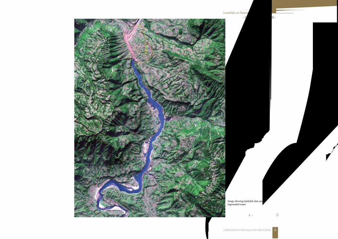
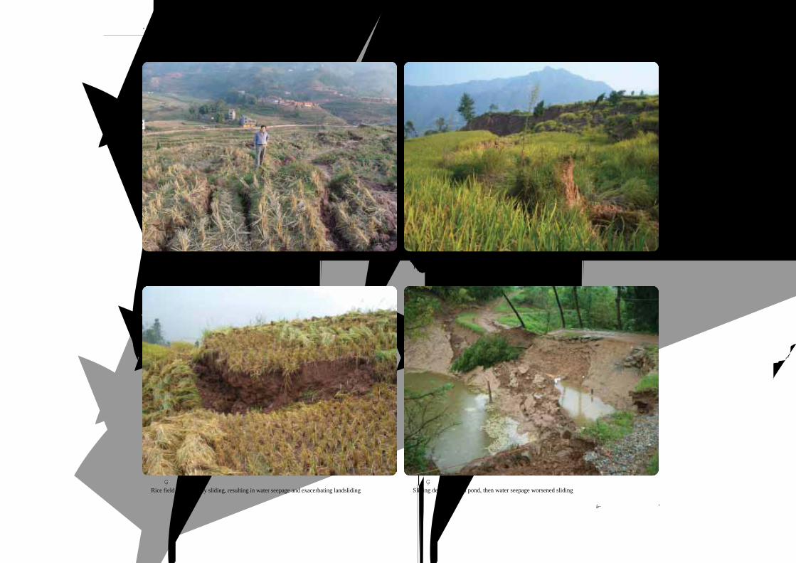
四川宣汉天台乡特大滑坡Large Scale Landslide at Tiantai Village, Xuanhan County, Sichuan Province
滑坡发生于 2004年 9月 5日,暴雨诱发。1255人受灾,摧毁房屋 2983间,毁田 1097亩。属基岩顺层滑坡,平面形态呈“圈椅”状,纵
长 950~1200m,横宽 1400~1600m,面积 1.2km2。滑床以砂岩为主,后陡前缓的折线形,前部顺层滑动,坡度 5OOOOO~7OOOOO ,后部切层,坡度渐
变为 20OOOOO~40OOOOO ,主滑方向 95OOOOO 。滑体以紫红色粉质粘土夹泥岩块石和泥岩碎裂岩体为主,厚度一般为 7~49m,平均厚度 23m,滑体总体积
2500万m3,其中约 210万m3堆积物冲入前河中。
The Tiantai landslide occurred on September 5, 2004, due to heavy rainfall, 2983 houses and 1097 Mu of farmland were destroyed; 1255 persons
suffered damage. It was lobate shaped in plane view with dimensions in 950-1200 m long, 1400 -1600 m wide, 23 m thick. The basal bed is a sandstone
layer dipping 5OOOOO- 7O O O O O at the toe and 20OOOOO- 40O O O O O near the crest. The landslide has a volume of 25 million m3 ; is made up of purple-red silty clay with intercalations
of mudstone. About 2.1 million m3 of sliding materials caused the damming of the river.
·四川宣汉天台乡特大滑坡·
1.顺层 滑坡Landslides on Dipping Beds
3LANDSLIDES IN CHINA-SELECTED CASE STUDIES
滑坡及堵江回水遥感影像
Image showing landslide dam andimpounded water
(本照片由王治华提供)

·四川宣汉天台乡特大滑坡·
4 中国典型滑坡
滑坡后“ 3D”遥感影像 Oblique image after sliding滑坡前“3D”遥感影像 Oblique image before sliding
滑坡淹没上游村镇 Submerged village due to landslide impoundment
(本照片由赵松江提供)
(本版遥感影像由中国国土资源航空物探遥感中心提供)
滑坡前部冲入前河中,抬高河床23~28m,造成
河道严重堵塞,形成回水长 15km、库容 5800万m3
的堰塞湖。淹没上游五宝场镇及沿河两岸共 8个村
5770户,农田4930亩,紧急转移受灾群众19 360人。
The landslide dammed the river and water level
rose 23-28 m creating an impoundment 15 km long and
58 million m3 in volume. Eight villages were flooded and
19 360 persons were evacuated.
·四川宣汉天台乡特大滑坡·
1.顺层 滑坡Landslides on Dipping Beds
5LANDSLIDES IN CHINA-SELECTED CASE STUDIES
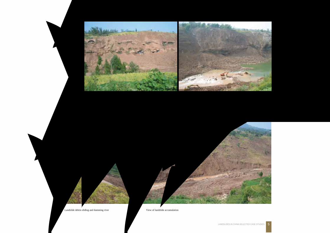
滑坡前缘剪出入江, 地下水沿滑带渗出Groundwater discharge along sliping zone
滑坡剪出滑入江, 形成滑坡坝体The sliding mass fell into and dammed the river
入江滑坡体形成堰塞湖
Landslide debris sliding and damming river滑坡体前缘概貌
View of landslide accumulation
·四川宣汉天台乡特大滑坡·
6 中国典型滑坡
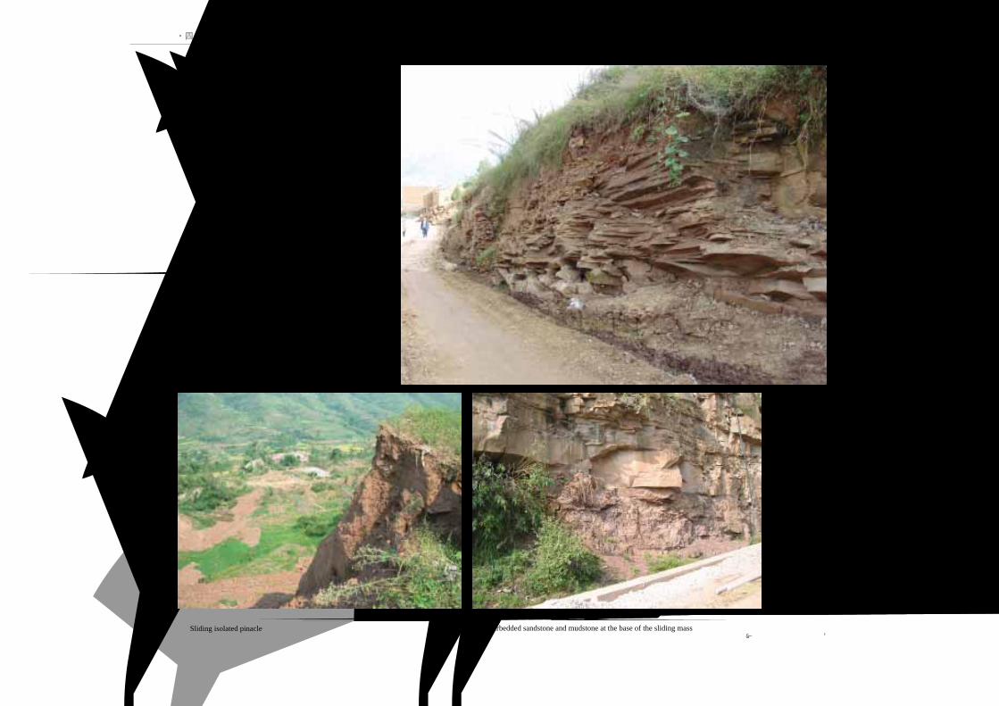
滑坡下伏滑床砂岩呈层状碎裂岩体,
富水性好
Laminar sandstone at the base of the slidingmass initially large amount of water
滑坡下伏滑床为砂岩泥岩互层结构
Interbedded sandstone and mudstone at the base of the sliding mass滑坡体孤丘
Sliding isolated pinacle(本照片由赵松江提供)
·四川宣汉天台乡特大滑坡·
1.顺层 滑坡Landslides on Dipping Beds
7LANDSLIDES IN CHINA-SELECTED CASE STUDIES
滑坡柱体
Sliding isolated pinacle
残留滑坡柱体显示滑坡原厚度和结构
Residual pillar showing the structure and thickness of landslide
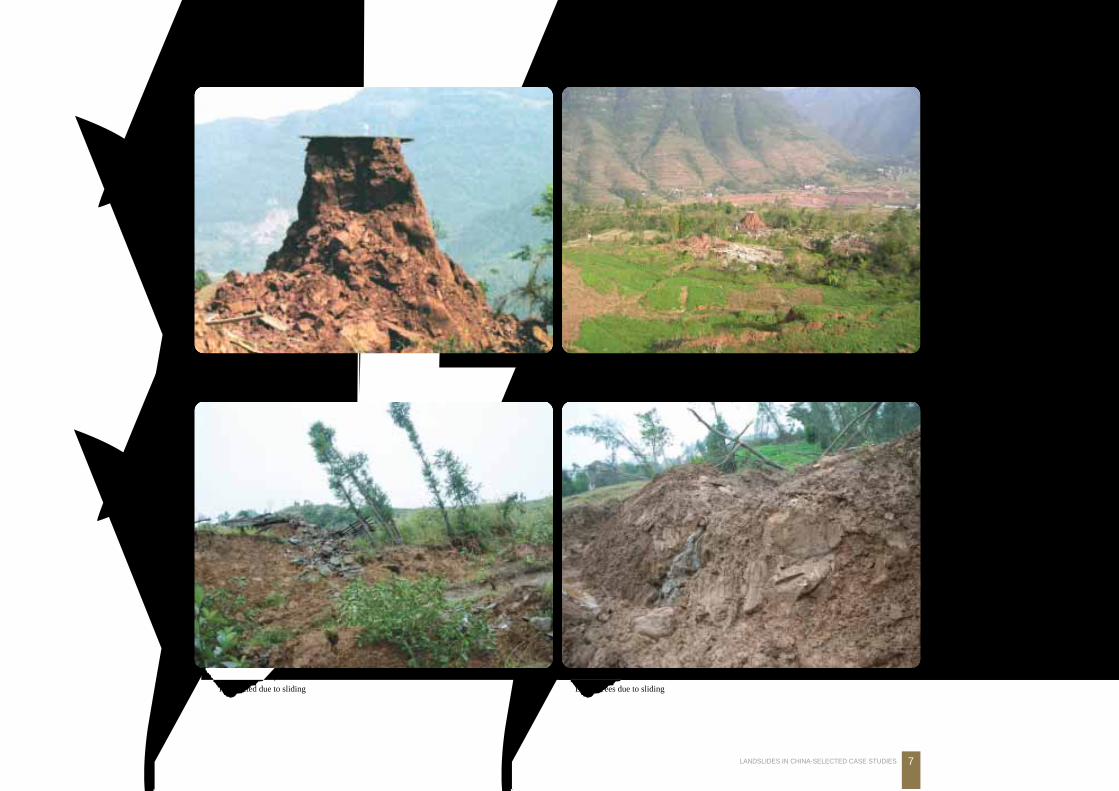
滑坡变形拉裂, 树木歪斜Trees tilted due to sliding
滑坡变形拉裂形成醉汉林
Drunk trees due to sliding
·四川宣汉天台乡特大滑坡·
8 中国典型滑坡
稻田水渗入滑坡体, 促进了滑坡的变形拉裂Water seepage from rice field increased deformation and cracks
滑坡变形拉裂, 稻田下陷成地堑Rice field subsidence due to sliding
池塘被毁, 池水入渗促使滑动加剧Sliding destroyed this pond, then water seepage worsened sliding
稻田被毁, 田水入渗促使滑动加剧Rice field destroyed by sliding, resulting in water seepage and exacerbating landsliding
(本照片由赵松江提供)
·三峡工程重庆库区云阳老县城五峰山滑坡·
1.顺层 滑坡Landslides on Dipping Beds
9LANDSLIDES IN CHINA-SELECTED CASE STUDIES
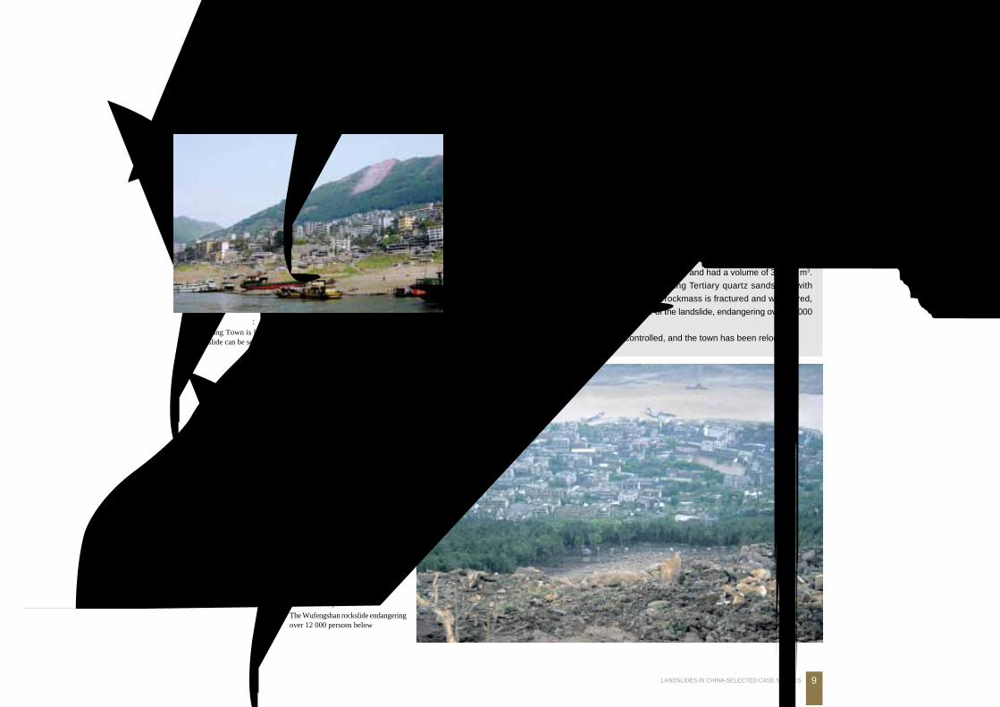
三峡工程重庆库区云阳老县城五峰山滑坡Wufengshan Rockslide in Old Yunyang Town, Chongqing, Three Gorges Reservoir
云阳老县城滑坡: 老县城坐落在西城滑坡体上, 后山为五峰山滑坡Yunyang Town is located on the Xicheng landslide and the Wufengshanrockslide can be seen behind
五峰山滑坡对老县城 1.2万余人
生命财产构成严重威胁
The Wufengshan rockslide endangeringover 12 000 persons below
滑坡发生于 2001年 1月 17日,从高程 607.7m顺层下滑,沿 570m高程处剪出,
并带动老滑坡残体碎块石土顺层下滑,堆积于380~410m高程上。体积3万m3左右。
危及1.2万余人生命财产安全。滑坡原岩为遂宁组第二段中厚层石英粉岩夹薄层泥岩,
地形坡度及岩层倾角近于一致,为48OOOOO~54OOOOO ,层面裂隙及纵横向节理裂隙发育,前缘
临空条件好,且前缘 360m左右高程有地下水溢出。
滑坡发生后,当地政府迅速组织有关单位进行应急处理,确保了春节和汛期期间
人民生命财产的安全。
Wufengshan rockslide occurred on January 17, 2001, and had a volume of 30 000 m3.
The translational rockslide is made of inclined bedding Tertiary quartz sandstone with
intercalations of weathered mudstone. The bedded rockmass is fractured and weathered,
and the groundwater is discharged at the toe zone of the landslide, endangering over 12 000
persons.
The Wufengshan rockslide has been controlled, and the town has been relocated.
五 峰 山 滑 坡
江 长
·三峡工程重庆库区云阳老县城五峰山滑坡·
10 中国典型滑坡
江
长
宝
坡滑
塔
鸡扒
子 滑
五
峰
山
滑
坡
坡
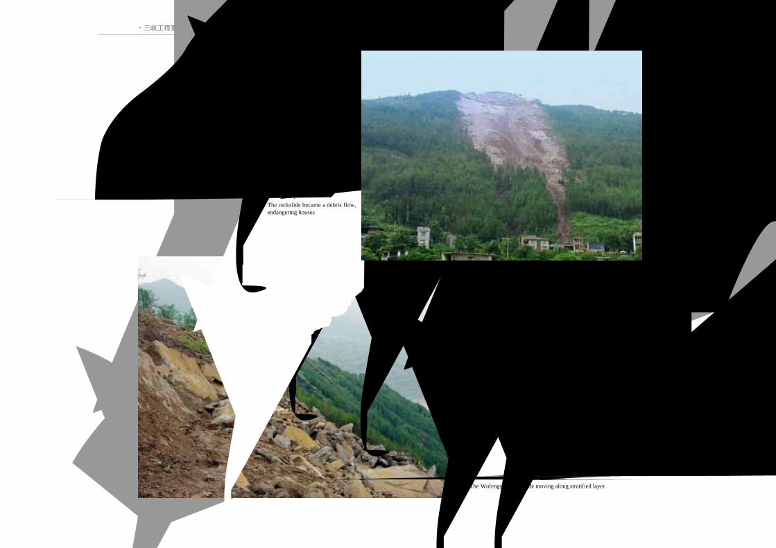
五峰山滑坡转化为泥石流, 对下
部居民构成威胁
The rockslide became a debris flow,endangering houses
五峰山滑坡沿单斜岩层顺层滑动
The Wufengshan rockslide moving along stratified layer

·三峡工程重庆库区云阳老县城五峰山滑坡·
1.顺层 滑坡Landslides on Dipping Beds
11LANDSLIDES IN CHINA-SELECTED CASE STUDIES
五峰山滑坡后缘 Landslide rear 五峰山滑坡表层植被茂密, 形成厚达数米的易滑体Extensive vegetation covers the rockslide which is several metres thick
单斜地层由泥岩和砂岩互层构成
Monoclina rockmass is made up of alternating sandstone and mudstone滑坡浅表层形成风化卸荷带
Stress relief weathered zone
·三峡工程重庆库区云阳老县城五峰山滑坡·
12 中国典型滑坡
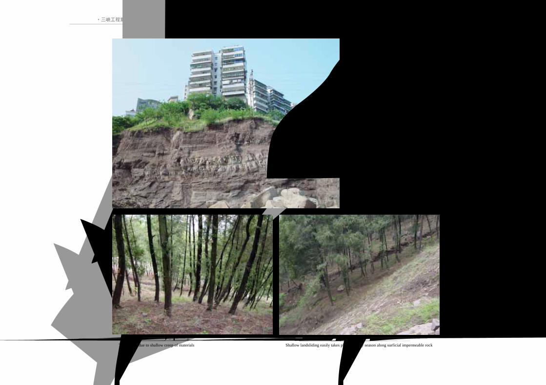
浅表层岩土体蠕滑下形成“马刀树”
Tilted trees due to shallow creep of materials浅表层岩土体下伏隔水岩层, 雨季易形成顺层滑动Shallow landsliding easily takes place in rainy season along surficial impermeable rock
“三明治”边坡对上部建筑物构成威胁
“Sandwich” layering slope that endangered buildings
·三峡工程重庆库区云阳老县城五峰山滑坡·
1.顺层 滑坡Landslides on Dipping Beds
13LANDSLIDES IN CHINA-SELECTED CASE STUDIES
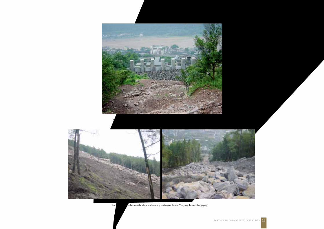
采用钢筋砼抗滑拦挡桩防治滑坡碎屑流危害县城
Reinforced concrete pile and defense net prevented the landslide and debris from reaching the town
滑坡体堆积于斜坡上, 对下部县城构成威胁Rockslide accumulates on the slope and severely endangers the old Yunyang Town, Chongqing
长 江
·三峡工程重庆库区云阳老县城五峰山滑坡·
14 中国典型滑坡
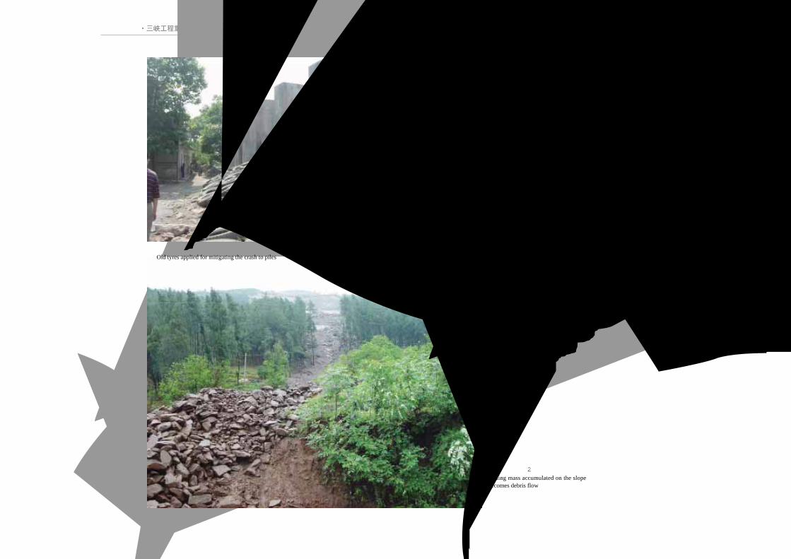
在拦挡工程前缘铺设废旧轮胎减缓碎屑流撞击桩
Old tyres applied for mitigating the crash to piles
斜坡上的滑坡堆积体转化为碎屑流
Sliding mass accumulated on the slopebecomes debris flow
拦挡工程下部居民处于安全之中
Lives are now protected by engineering work

·三峡库区单斜顺向坡远眺·
1.顺层 滑坡Landslides on Dipping Beds
15LANDSLIDES IN CHINA-SELECTED CASE STUDIES
三峡库区单斜顺向坡远眺Overview of Inclined Bedding Slope in the Three Gorges Reservoir
云阳-奉节沿故陵向斜两翼发育一系列滑坡,包括旧县坪、宝塔、藕塘等巨型滑坡Huge scale inclined bedding landslides are distributed along the Gulin syncline between Yunyangand Fengjie, such as Jiuxianping, Baota and Ou'tang landslides

·三峡库区单斜顺向坡远眺·
16 中国典型滑坡
古 滑 坡 反 倾 平 台
奉节藕塘巨型滑坡
The huge scale Ou'tang landslide, Fengjie, Chongqing
古 滑 坡 平 台
奉节藕塘巨型滑坡前缘反倾平台
Backtilted toe of the Ou'tang huge landslide

·三峡库区单斜顺向坡远眺·
1.顺层 滑坡Landslides on Dipping Beds
17LANDSLIDES IN CHINA-SELECTED CASE STUDIES
岩层顺层下滑, 田水沿裂缝入渗, 加剧岩体失稳Sliding on dipping beds; water penetrates fractures, exacerbating landsliding
云阳旧县坪巨型滑坡
The large scale Jiuxianping stratified landslide
云阳旧县坪巨型滑坡前缘
Backtilted accumulation at the toeof the Jiuxianping large landslide
古 滑 坡 平 台
古 滑 坡 反 倾 平 台
·青海尖扎康阳-夏藏滩滑坡群全貌·
18 中国典型滑坡
Mudslides and Fallsin Tertiary Materials
2.第三系
泥岩滑坡与崩塌
MUDSLIDES AND FALLS IN TERTIARY MATERIALS
MUDSLIDES AND FALLS IN TERTIARY MATERIALS
MUDSLIDES AND FALLS IN TERTIARY MATERIALSMUDSLIDES AND FALLS IN TERTIARY MATERIALS

2.第三系泥岩滑坡与 崩塌
·青海尖扎康阳-夏藏滩滑坡群全貌·
Mudslides and Falls in Tertiary Materials
19LANDSLIDES IN CHINA-SELECTED CASE STUDIES
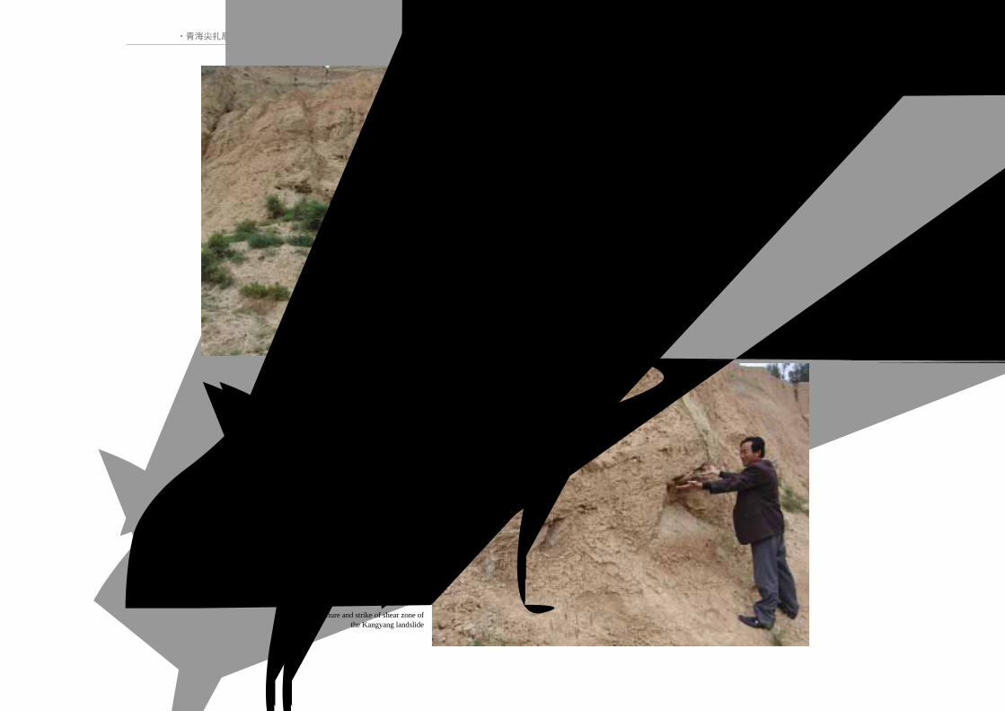
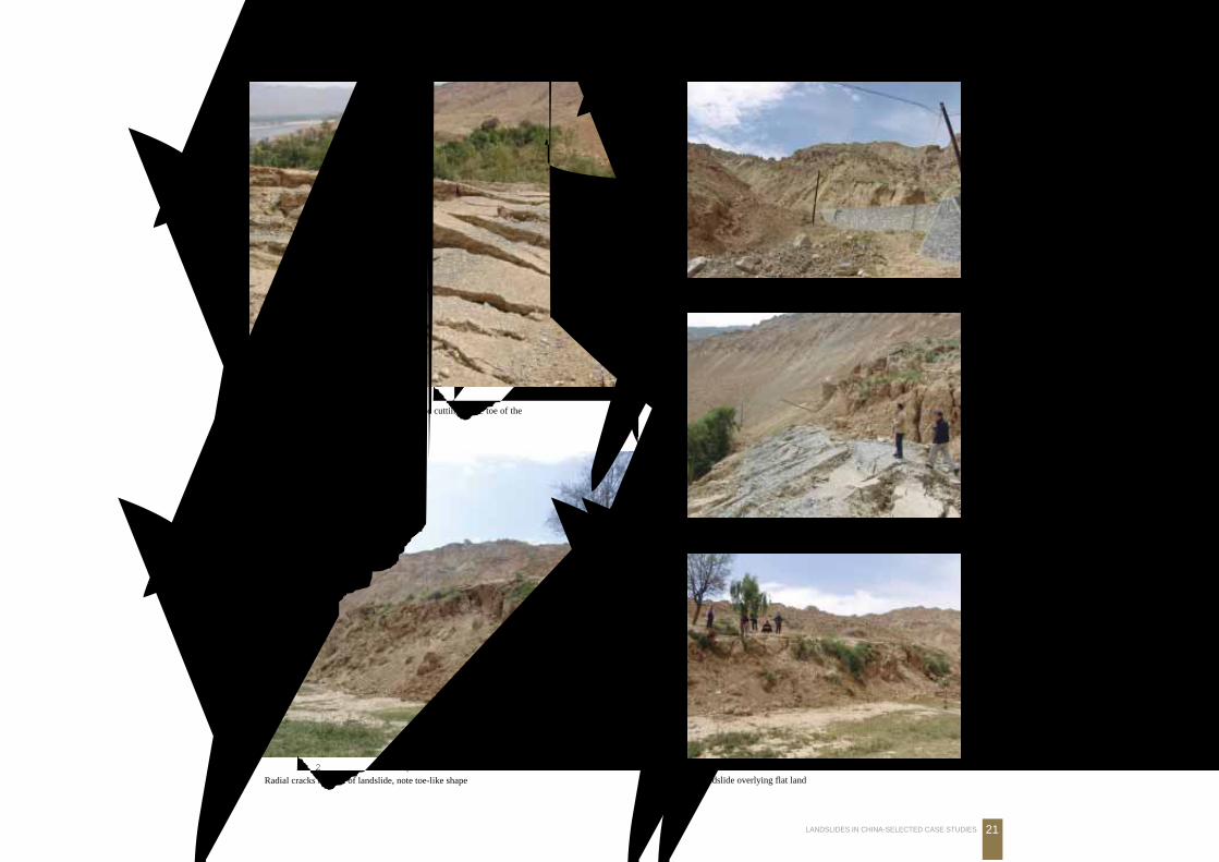
青海尖扎康阳-夏藏滩滑坡群全貌Kangyang–Xiazangtan Landslide Cluster in Jianzha County, Qinghai Province
位于黄河公伯峡库尾,尖扎县西10km黄河右岸。其中,康阳滑坡长3100m,宽 3300m,厚100m,体积约10.23亿m3。由
第三系紫红色泥岩构成,滑坡高差约500m,可划分为 9级平台。滑坡超覆于黄河Ⅲ级阶地卵砾石层上。由于滑坡前缘切脚修
路,2005年滑坡体局部复活滑动,体积约数千万立方米。
Kangyang landslide is located on the right shore of the Gongboxia Gorge Reservior, in the upper reaches of the Yellow River. The
landslide is one of the largest in China; it is 3100 m long, 3300 m wide, 100 m thick and has a volume of 1.023 billion m3. The landslide
is made up of Tertiary purple-red mudstone. The landslide consists of 9 terraces with a total height difference of about 500 m from crown
to toe. In August, 2005, the accumulation lobe was reactivated by highway slope cutting, disrupting millions of cubic metres of landslide
materials.
ATERIALS
夏 藏 滩 滑 坡
康
阳
滑
坡
河 黄
·青海尖扎康阳-夏藏滩滑坡群全貌·
20 中国典型滑坡
第三系泥岩 (N) 超覆于第四纪阶地 (Q) 之上, 滑带明显Tertiary mudstone overlying the Quaternary terrace (intercalationwith gravel)
Q
N
滑 带
康阳滑坡滑带结构及产状明显
Structure and strike of shear zone ofthe Kangyang landslide
2.第三系泥岩滑坡与 崩塌
·青海尖扎康阳-夏藏滩滑坡群全貌·
Mudslides and Falls in Tertiary Materials
21LANDSLIDES IN CHINA-SELECTED CASE STUDIES
康阳滑坡西部因前缘开挖失稳滑动, 公路形成大量纵张裂缝Longitudinal cracks along road due to slope cutting at the toe of theKangyang landslide, Jianzha, Qinghai
新滑坡体上形成大量土林
Soil pillars (“forest-like”) on the reactivated landslide accumulation
因前缘开挖失稳滑动, 公路毁坏Road destroyed at the toe of the landslide due to road cut
新滑坡前缘堆积体纵张裂缝发育, 形如脚趾Radial cracks in front of landslide, note toe-like shape
新滑坡体滑覆在黄河Ⅱ级阶地上
Landslide overlying flat land
·青海西宁北山林家崖滑坡区·
22 中国典型滑坡
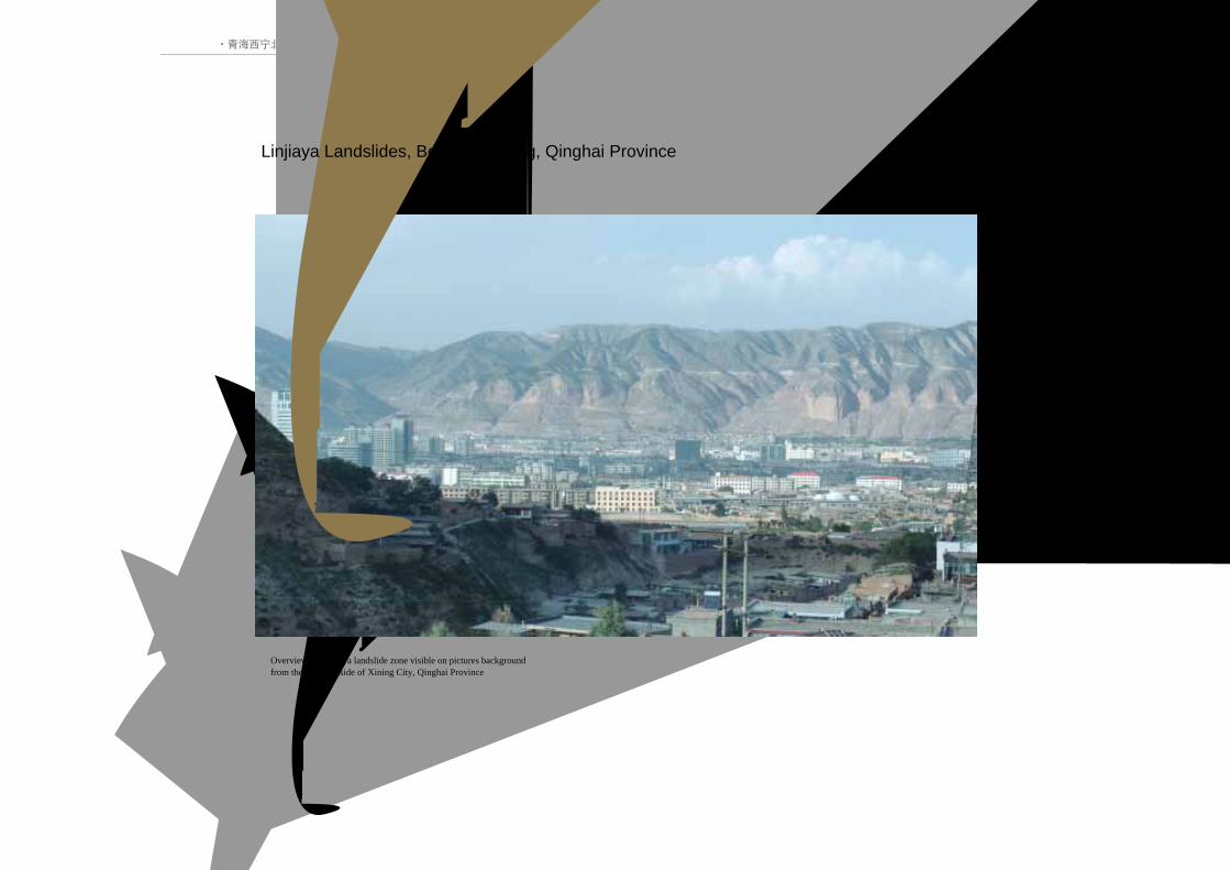
青海西宁市北山林家崖滑坡区远眺
Overview of Linjiaya landslide zone visible on pictures backgroundfrom the northern side of Xining City, Qinghai Province
青海西宁北山林家崖滑坡区Linjiaya Landslides, Beishan, Xining, Qinghai Province
2.第三系泥岩滑坡与 崩塌
·青海西宁北山林家崖滑坡区·
Mudslides and Falls in Tertiary Materials
23LANDSLIDES IN CHINA-SELECTED CASE STUDIES
第三系泥岩中膏盐溶蚀后, 形
成错落型滑坡
Backtilted (rotated) sliding due togypsum dissolution in Tertiarymudstone
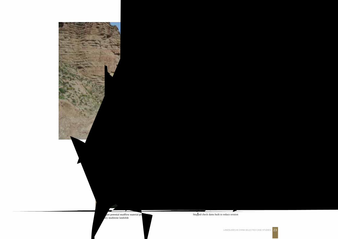
第三系泥岩滑坡后形成泥石流物源
Abundant potential mudflow material provided byTertiary mudstone landslide
第三系泥岩泥石流沟谷坊防治工程
Stepped check dams built to reduce erosion
·青海西宁北山林家崖滑坡区·
24 中国典型滑坡
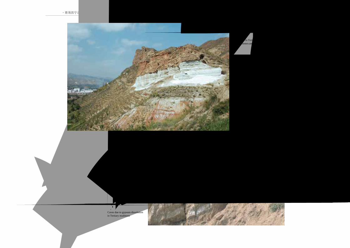
第三系泥岩中富含膏盐。溶蚀
后, 形成大量空洞Caves due to gypsum dissolutionin Tertiary mudstone
第三系泥岩中膏盐厚达数米, 构成滑坡或崩
塌的底面
The gypsum in Tertiany mudstone has a thicknessof several meters and forms the base for the landslide
2.第三系泥岩滑坡与 崩塌
·青海西宁北山林家崖滑坡区·
Mudslides and Falls in Tertiary Materials
25LANDSLIDES IN CHINA-SELECTED CASE STUDIES
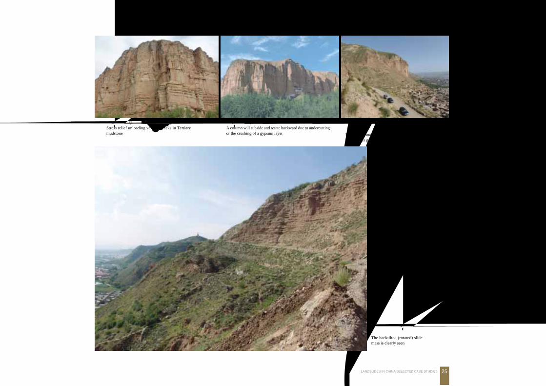
西宁市周边第三系泥岩错
落型滑坡
The backtilted (rotated) slidemass is clearly seen
第三系泥岩被数组节理切割。下伏膏盐溶蚀后,
形成规模较大的滑坡
Large rotational landslide caused by fractured mudstonefailure after gypsum dissolution at the landslide base
第三系泥岩被数组节理切割, 卸荷裂隙发育Stress relief unloading vertical cracks in Tertiarymudstone
第三系泥岩被数组节理切割风化卸荷形成危岩体
A column will subside and rotate backward due to undercuttingor the crushing of a gypsum layer
·青海西宁北山林家崖滑坡区·
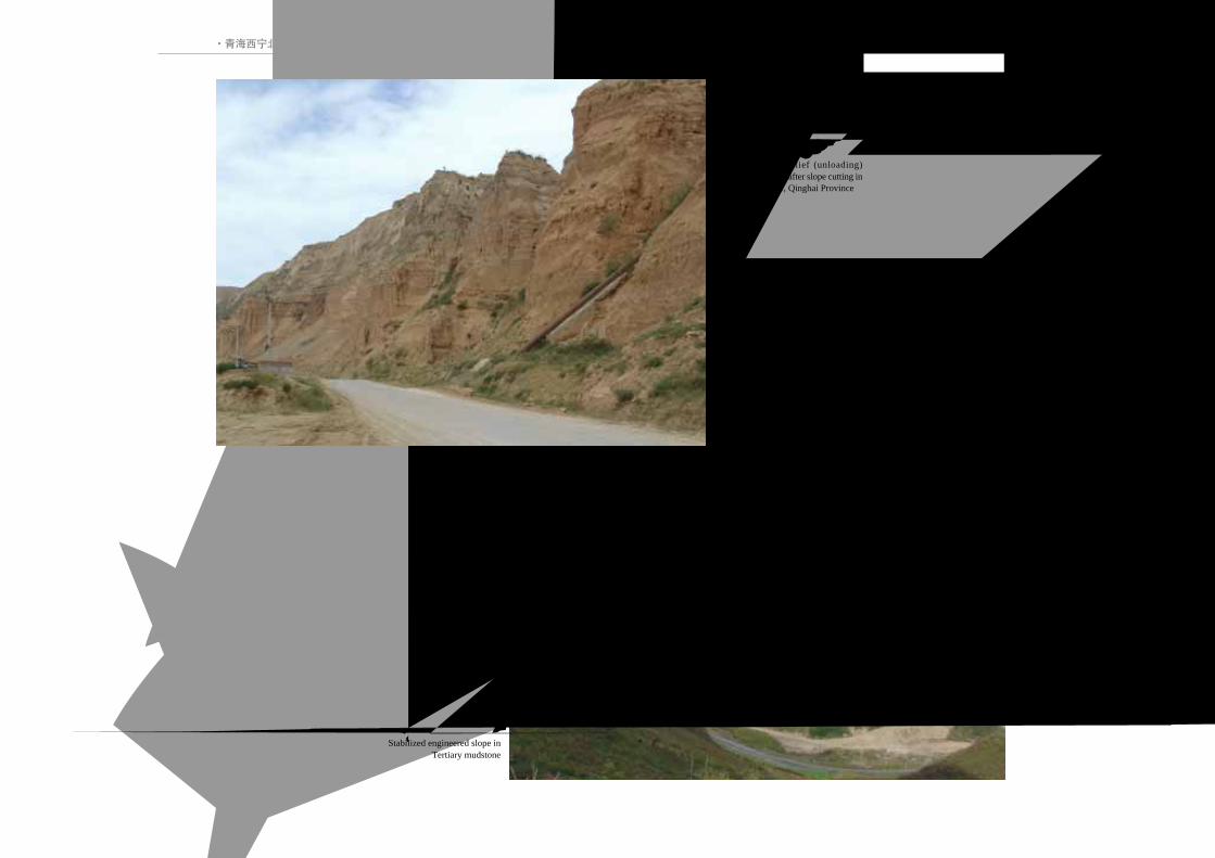
26 中国典型滑坡
第三系泥岩边坡开挖后, 卸荷裂隙
发育, 稳定性差Abundant stress relief (unloading)fractures developed after slope cutting inTertiary mudstone, Qinghai Province
第三系泥岩边坡加固工程
Stabilized engineered slope inTertiary mudstone
Landslides in Loess3.黄土 滑坡
27LANDSLIDES IN CHINA-SELECTED CASE STUDIES
Landslides in Loess
LANDSLIDES IN LOESSLANDSLIDES IN LOESS
3.黄土滑坡
LANDSLIDES IN LOESS LANDSLIDES IN LOESS
LANDSLIDES IN LOESS

·甘肃兰州皋兰山滑坡·
28 中国典型滑坡
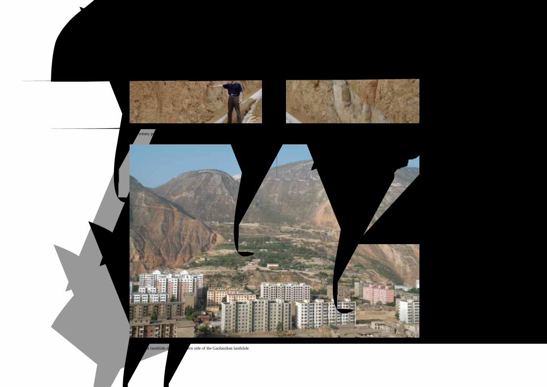
甘肃兰州皋兰山滑坡 *
Gaolanshan Landslide in Lanzhou, Gansu Province
*本滑坡照片由赵成、余志山提供
皋兰山滑坡全貌 Overview of Gaolanshan landslide
位于兰州市中心区的南侧,相对高差
600余米。皋兰山北坡形成一系列滑坡。其
中,皋兰山滑坡规模最大、最危险,具有多
级和多次活动特征,由3个次级滑坡区组成,
即1号滑坡区、2号滑坡区和3号滑坡区,总
体积约 2056万m3。直接威胁山下的兰州市
区安全。
The Gaolanshan landslide is located on
the southern side of Lanzhou City. The landslide
consists of three sub-landslides, and is 20.56
million m3 in total volume, with multi-layers and
multi-activities.The landslide height difference
is about 600m that is directly endangering the
district below.
1 号 滑 坡 区
2 号 滑 坡 区
滑坡及下部居民区远景
Overview of landslide and affected zone below皋兰山滑坡及下部居民区
Gaolanshan landslide is endangering buildings below

·甘肃兰州皋兰山滑坡·
Landslides in Loess3.黄土 滑坡
29LANDSLIDES IN CHINA-SELECTED CASE STUDIES
1号滑坡前缘建筑物密集分布Numerous buildings in front of the landslide
1号滑坡前缘抗滑桩支挡工程, 确保建筑物安全No.1 landslide was stabilized by retaining piles at the toe
1号滑坡及前缘建筑物No.1 sub-landslide and endangered buildings
1号滑坡后部Rear of the No.1 landslide
·甘肃兰州皋兰山滑坡·
30 中国典型滑坡
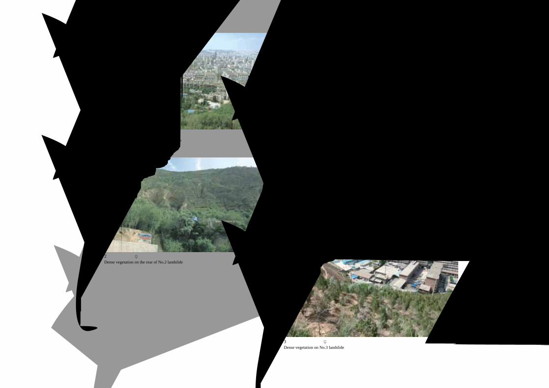
3号滑坡和老狼沟滑坡前部No.3 landslide and the lobe of Laolanggou landslide
3号滑坡体上人工植被良好Dense vegetation on No.3 landslide
2号滑坡前缘形成反倾平台Backtilted platform in front of No.2 landslide
2号滑坡后缘植被良好Dense vegetation on the rear of No.2 landslide
·甘肃兰州皋兰山滑坡·
Landslides in Loess3.黄土 滑坡
31LANDSLIDES IN CHINA-SELECTED CASE STUDIES
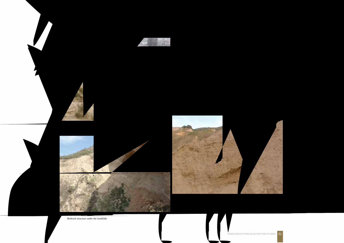
滑坡下伏基岩地层结构
Bedrock structure under the landslide
2号滑坡上部古冲沟及含砾石堆积物, 表明滑坡为古滑坡Scars and gravel deposit in upper No.2 landslide indicating ancient landslide activity
2号滑坡体上黄土岩溶发育Loess karst in No.2 landslide
2号滑坡体上黄土体冲沟和天桥Loess trench and bridges in No.2 landslide
2号滑坡前缘形成反倾平台
第三系顶部五泉砾岩
古冲沟及含砾石堆积
2号滑坡体
接触带
·甘肃兰州皋兰山滑坡·
32 中国典型滑坡
位于皋兰山滑坡东侧的老狼沟古滑坡
Ancient landslide near the eastern side of the Gaolanshan landslide
皋兰山滑坡下伏的第三系紫红色泥岩
Tertiary purple-red mudstone under the Gaolanshan landslide
第三系泥岩夹砂岩中构造节理发育
Joints in Tertiary mudstone interbedded with sandstone
老狼沟滑坡后缘壁
皋兰山滑坡
第三系泥岩构造节理
·甘肃永靖黑方台黄土滑坡群·
Landslides in Loess3.黄土 滑坡
33LANDSLIDES IN CHINA-SELECTED CASE STUDIES
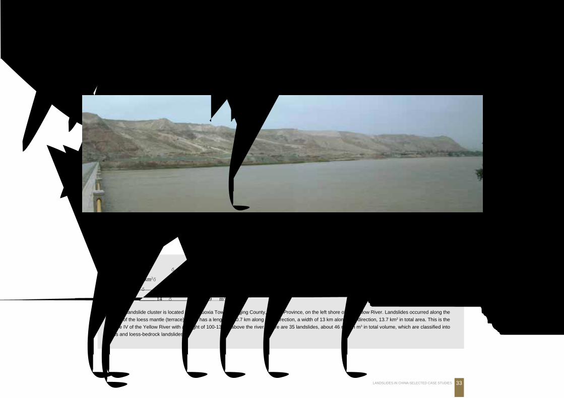
甘肃永靖黑方台黄土滑坡群Heifangtai Loess Landslide Cluster in Yongjing County, Gansu Province
黑方台焦家-扶河桥滑坡带远景 (由于古土壤隔水, 上部土地浇灌后, 沿黄土与古土壤形成滑带)Overview of Heifangtai landslides (Jiaojia-Fuheqiao)
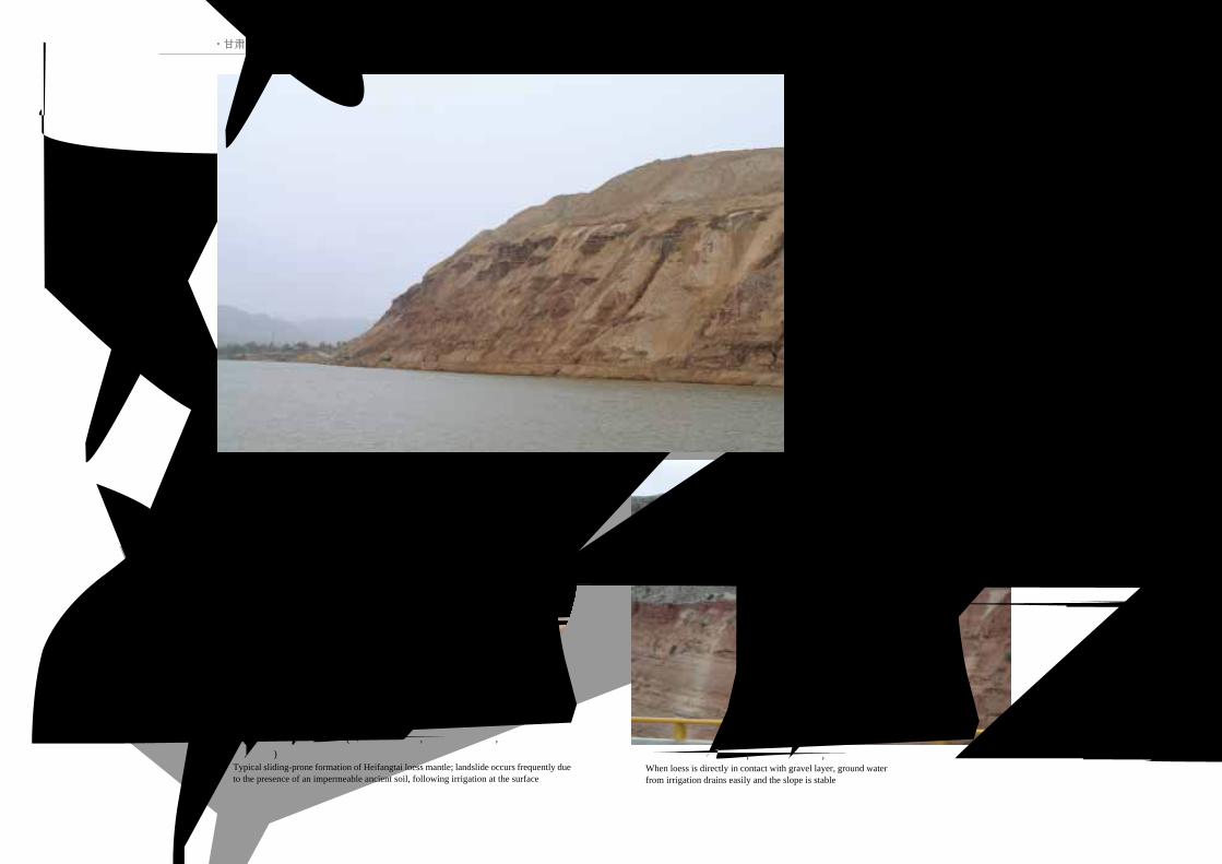
位于甘肃永靖盐锅峡镇,地处黄河和湟水交会处的黄河左岸,其台缘从湟水入黄河口的湟水桥头至盐锅峡大坝,东西长约10.7km,南北宽13km,
台塬面积约 13.7km2,为黄河Ⅳ级基座阶地。台面较为平坦,呈典型的黄土台塬地貌形态特征。台地高出周围地形 100~133m。黑方台边坡地带共
发育 35处滑坡,滑坡总体积 4605.6万m3。黑方台滑坡可分为黄土滑坡和黄土-基岩滑坡两种类型。共发育 21处黄土滑坡,总体积 1304.7万m3;
发育黄土-基岩滑坡 14处,总体积约 3300.9万m3。
The landslide cluster is located in Yanguoxia Town, Yongjing County, Gansu Province, on the left shore of the Yellow River. Landslides occurred along the
margin of the loess mantle (terrace) which has a length of 10.7 km along E-W direction, a width of 13 km along S-N direction, 13.7 km2 in total area. This is the
terrace IV of the Yellow River with a height of 100-133 m above the river. There are 35 landslides, about 46 million m3 in total volume, which are classified into
loess and loess-bedrock landslides.
黑方台黄土台塬
焦家滑坡
黄 河
·甘肃永靖黑方台黄土滑坡群·
34 中国典型滑坡
Q3黄土层
Q2古土壤层
Q1砾石层
黑方台黄土台塬地层结构 (由于古土壤隔水, 上部土地浇灌后, 沿黄土与古土壤
形成滑带)Typical sliding-prone formation of Heifangtai loess mantle; landslide occurs frequently dueto the presence of an impermeable ancient soil, following irrigation at the surface
黄土直接与砾石层接触, 地下水易于渗漏, 斜坡稳定性好When loess is directly in contact with gravel layer, ground waterfrom irrigation drains easily and the slope is stable
黑方台黄土台塬斜坡前沿沿黄土与古土
壤接触带形成滑坡
Slope along the margin of the Heifangtai loessterrace (mantle). Landslide occurred along thecontact zone of loess and ancient soil
黄 河
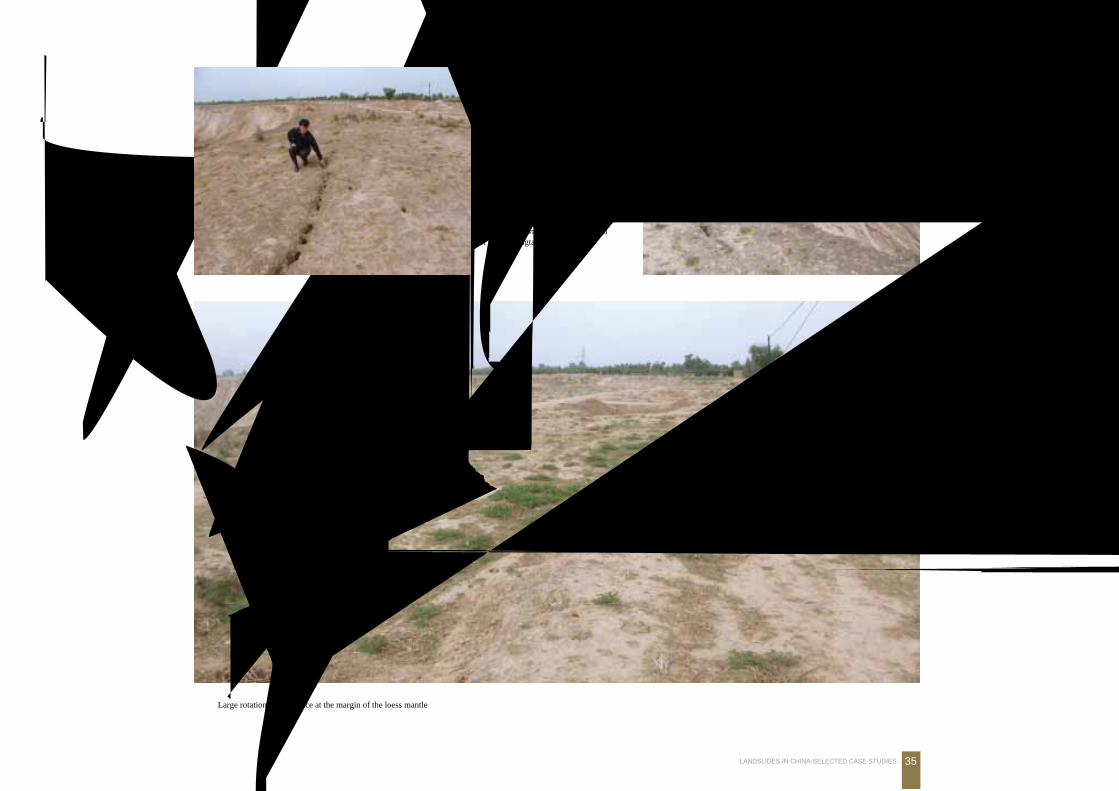
·甘肃永靖黑方台黄土滑坡群·
Landslides in Loess3.黄土 滑坡
35LANDSLIDES IN CHINA-SELECTED CASE STUDIES
黑方台黄土台塬边滑坡
Landslide scarp at the marginof the Heifangtai loess mantle
黑方台黄土台塬边大面积座滑
Large rotational subsidence at the margin of the loess mantle
黑方台黄土台塬边滑坡拉裂缝
Landslide crown cracks at the marginof the Heifangtai loess mantle
·甘肃永靖黑方台黄土滑坡群·
36 中国典型滑坡
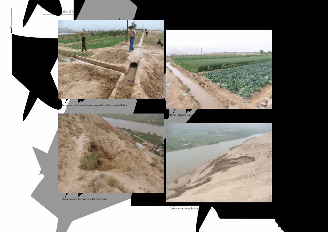
黑方台黄土台塬农田灌溉渠系
Irrigation system on the loess tableland, the Heifangtai tableland
黑方台黄土台塬农田漫灌, 易于渗入地下Broad irrigation is easy to seep
黑方台黄土台塬边溶蚀冲沟
Karst trench in the margin of the loess mantle
黑方台黄土台塬边地下水集中溢出, 构成滑带Groundwater strong discharge that is easy to slip
·甘肃永靖黑方台黄土滑坡群·
Landslides in Loess3.黄土 滑坡
37LANDSLIDES IN CHINA-SELECTED CASE STUDIES
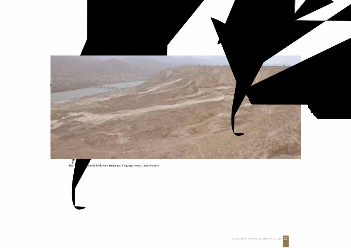
黑方台焦家-扶河桥滑坡带
The Jiaojia-Fuheqiao landslide zone, Heifangtai, Yongjing County, Gansu Province
黑方台台塬面
Q3黄土
地下水溢出带,也是滑坡底界
泥 流
·甘肃永靖黑方台黄茨滑坡·
38 中国典型滑坡
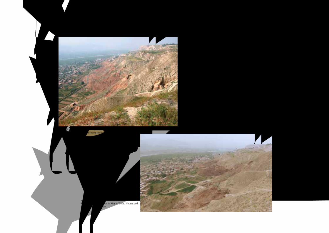
2006年 5月黄茨滑坡再次滑动, 毁坏房屋和田地Reactivation of landslide in May of 2006. Houses andfarmland were destroyed
甘肃永靖黑方台黄茨滑坡Huangci Landslide, Heifangtai Loess Mantle, Yongjing County, Gansu Province
1996年滑动后的黄茨滑坡 (滑坡呈三级叠瓦状台阶斜列 )Huangci landslide after the sliping in1996 [3 steps (terraces) obliquelyarranged]
(本照片由王恭先提供)
位于黑方台南缘,上覆厚层黄土的顺层岩石滑坡,主
滑方向为SE30OOOOO左右,直指黄茨村,危及 63户 300余人
安全。滑坡前缘宽约 300m,后缘宽约 500m,长 370m,
体积近 600万m3。该滑坡于 1995年 1月 30日发生大规
模滑坡,由于成功预报,未造成人员伤亡。2006年 5月
14日,再次复活,体积 320万m3,153间房屋被毁,道
路中断。
Huangci landslide is located at the margin of the Heifangtai
loess mantle.The landslide is made up of loess and bedded
mudstone, 300-500 m wide, 370 m long and 6 million m3 in
volume. The landslide started on January 30, 1995,
endangering 300 persons. No death was claimed because of
successful prediction. Since May 14, 2006, the landslide
reactivated, involving 3.2 million m3, 153 houses were
destroyed and traffic was interrupted.
黑方台台塬
1级台阶
2级台阶
3级台阶
水渠
黑方台台塬
1级台阶2级台阶
3级台阶
水渠被毁
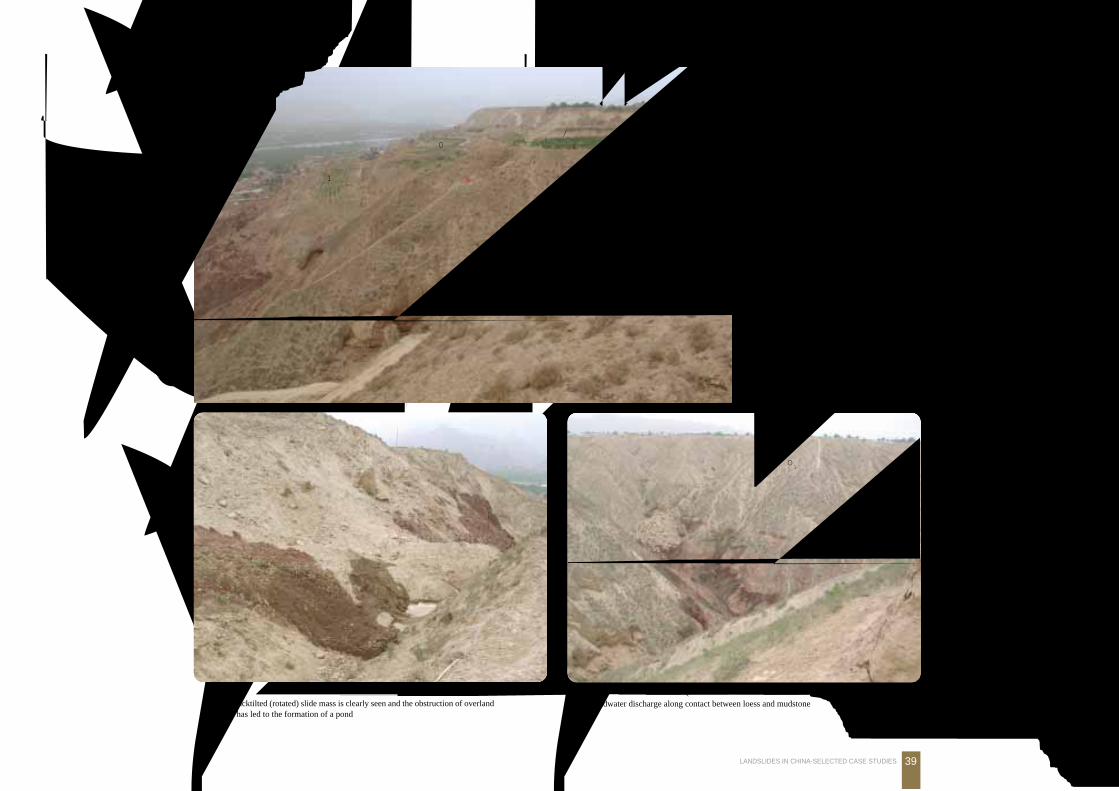
·甘肃永靖黑方台黄茨滑坡·
Landslides in Loess3.黄土 滑坡
39LANDSLIDES IN CHINA-SELECTED CASE STUDIES
黑方台黄茨滑坡地下水丰富
The backtilted (rotated) slide mass is clearly seen and the obstruction of overlandflow has led to the formation of a pond
黑方台黄茨滑坡岩土结构 (地下水沿黄土与泥岩接触带溢出)Groundwater discharge along contact between loess and mudstone
黄茨滑坡形成三级叠瓦状台阶
(2006年 6月)The Huangci landslide consists ofthree rotational slides (slumps)
黑方台台塬
1级台阶
2级台阶
3级台阶
滑坡前部
K泥岩
Q3黄土
K紫红色泥岩
·甘肃永靖黑方台黄茨滑坡·
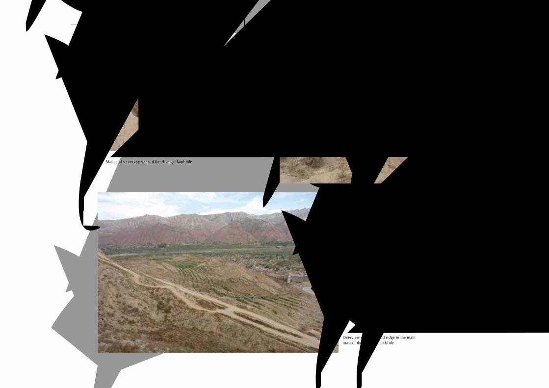
40 中国典型滑坡
黄茨滑坡体中部陷落前部滑坡脊远景
Overview of graben and ridge in the mainmass of the Huangci landslide
黄茨滑坡后缘形成多级陡坎
Main and secondary scars of the Huangci landslide
黄茨滑坡后缘
Main scar and unstable mass ofthe Huangci landslide

·甘肃永靖黑方台黄茨滑坡·
Landslides in Loess3.黄土 滑坡
41LANDSLIDES IN CHINA-SELECTED CASE STUDIES
黄茨滑坡体中部陷落前部形成滑坡
反向陡坎
Graben in the main mass and reversescars at the toe of the Huangci landslide
黄茨滑坡体中形成多级陡坎和裂缝
Multiple scars and transverse cracks of the Huangci landslide
黄茨滑坡体中部陷落前部形成滑坡脊
Graben and ridge in the main body of the Huangci landslide
·甘肃永靖黑方台黄茨滑坡·
42 中国典型滑坡
Q黄土 Q黄土
K泥岩K泥岩 剪出带
黄茨滑坡呈叠瓦状结构
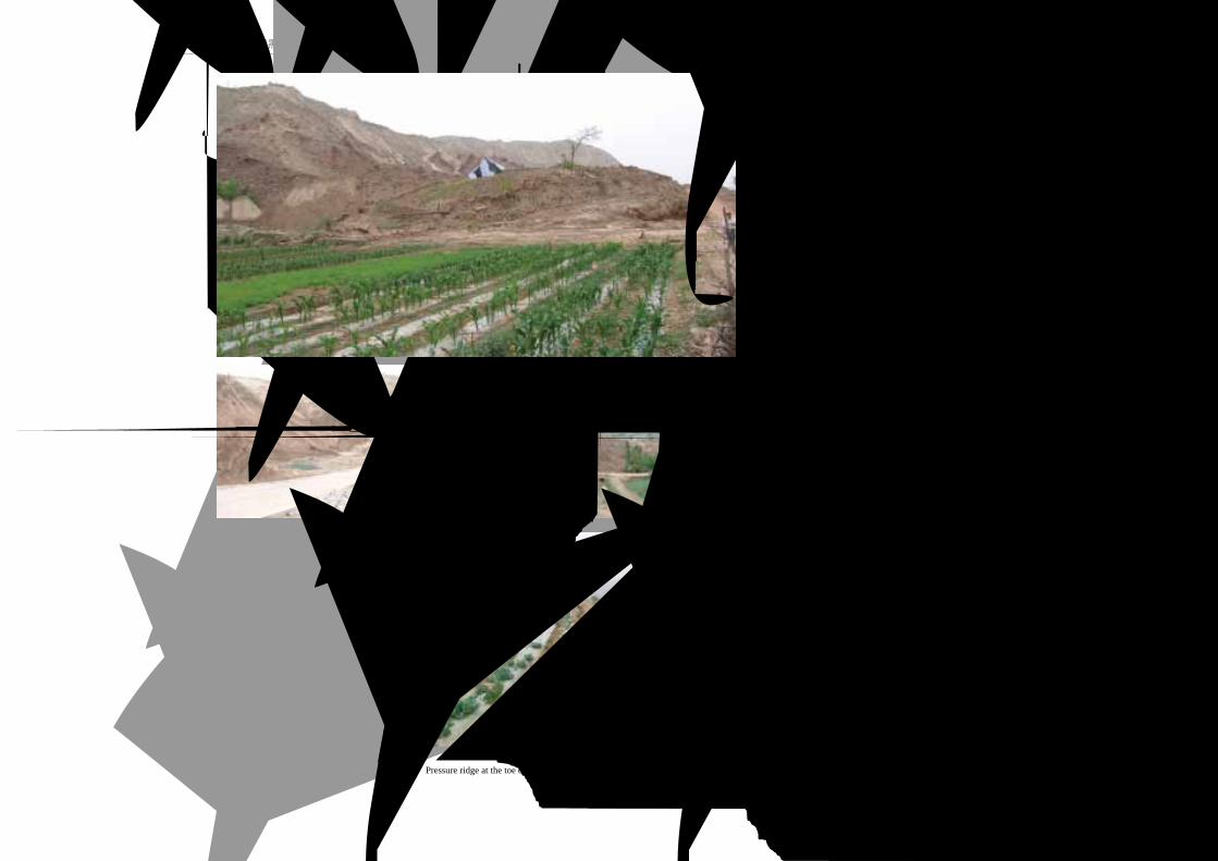
The Huangci landslide has producedoverridden structure (Quartenary loess)on the top of cretaceous mudstone
黄茨滑坡前缘剪出口 (菜地出现逆冲陡坎)Pressure ridge at the toe of the landslide
黄茨滑坡前缘地面出现鼓胀裂缝
Pressure cracks at the toe of the landslide
黄茨滑坡前缘逆冲剪出
The toe of the Huangci landslideoverlying original ground
·甘肃永靖黑方台黄茨滑坡·
Landslides in Loess3.黄土 滑坡
43LANDSLIDES IN CHINA-SELECTED CASE STUDIES
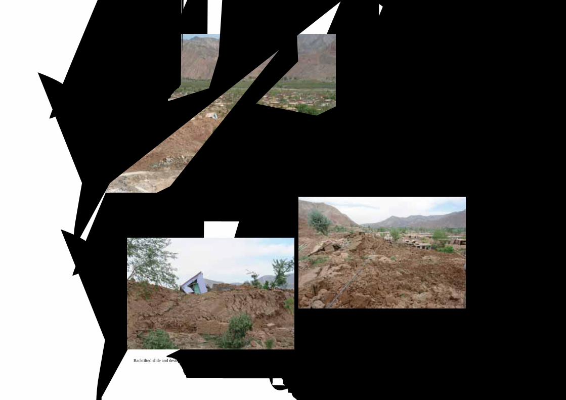
滑坡前缘反翘剪出
Backtilted slide and pressure ridge ofthe Huangci landslide
滑坡前缘反翘剪出, 毁坏民房和道路Backtilted slide and destroyed houses
滑坡前缘反翘剪出, 毁坏民房和道路Backtilted sliding mass and destroyed houses
·甘肃永靖黑方台黄茨滑坡·
44 中国典型滑坡
滑坡前缘堆积, 毁坏民房Accumulation lobe and destroyed houses
滑坡前缘鼓胀裂缝发育
Bulge and transverse cracks at the toeof the landslide
滑坡前缘反翘剪出, 毁坏民房和道路Backtilted slide and severed transportation

·陕西延安宝塔山滑坡·
Landslides in Loess3.黄土 滑坡
45LANDSLIDES IN CHINA-SELECTED CASE STUDIES
宝塔山的窑洞远眺
Overview of cave dwellings in Baotashan
陕西延安宝塔山滑坡远眺
Overview of the Baotashan landslideof Yan'an City, Shaanxi Province
宝塔山
延安新城
在宝塔山滑坡下部的窑洞和居民
Cave dwellings and citizens under the Baotashan landslide
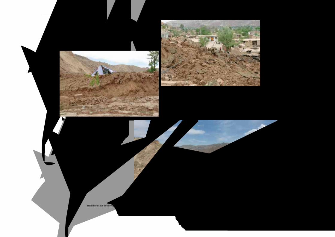
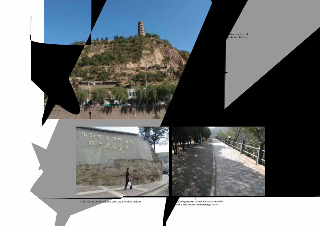
陕西延安宝塔山滑坡Baotashan Landslide of Yan'an City, Shaanxi Province
·陕西延安宝塔山滑坡·
46 中国典型滑坡
宝塔山黄土下部为稳固的延安组砂岩
Stable Yan'an Group sandstone under the Baotashan landslide
宝塔山滑坡顶部被硬化, 减低了降雨入渗Reducing seepage into the Baotashan landslidewith a hard top (low permeability) surface
陕西延安宝塔山滑坡
The Baotashan landslide ofYan'an City, Shaanxi Province
·陕西延安宝塔山滑坡·
Landslides in Loess3.黄土 滑坡
47LANDSLIDES IN CHINA-SELECTED CASE STUDIES
宝塔山滑坡侧壁
Lateral shear of the Baotashan landslide
宝塔山滑坡后缘及植被
The scarp of the Baotashan landslide and vegetation
宝塔山滑坡后缘局部塌滑
Some raveling of the scarp
加固后的宝塔山滑坡后缘壁
Reinforcement on the scarp of the Baotashan landslide
48 中国典型滑坡
菜秧沟黄土滑坡全貌
Closer overview of one of the Caiyanggou landslides, Yan'an City, Shaanxi Province
菜秧沟滑坡对面另一滑坡
Overview of the second Caiyanggou landslide(本版照片由张茂省、校佩喜提供)
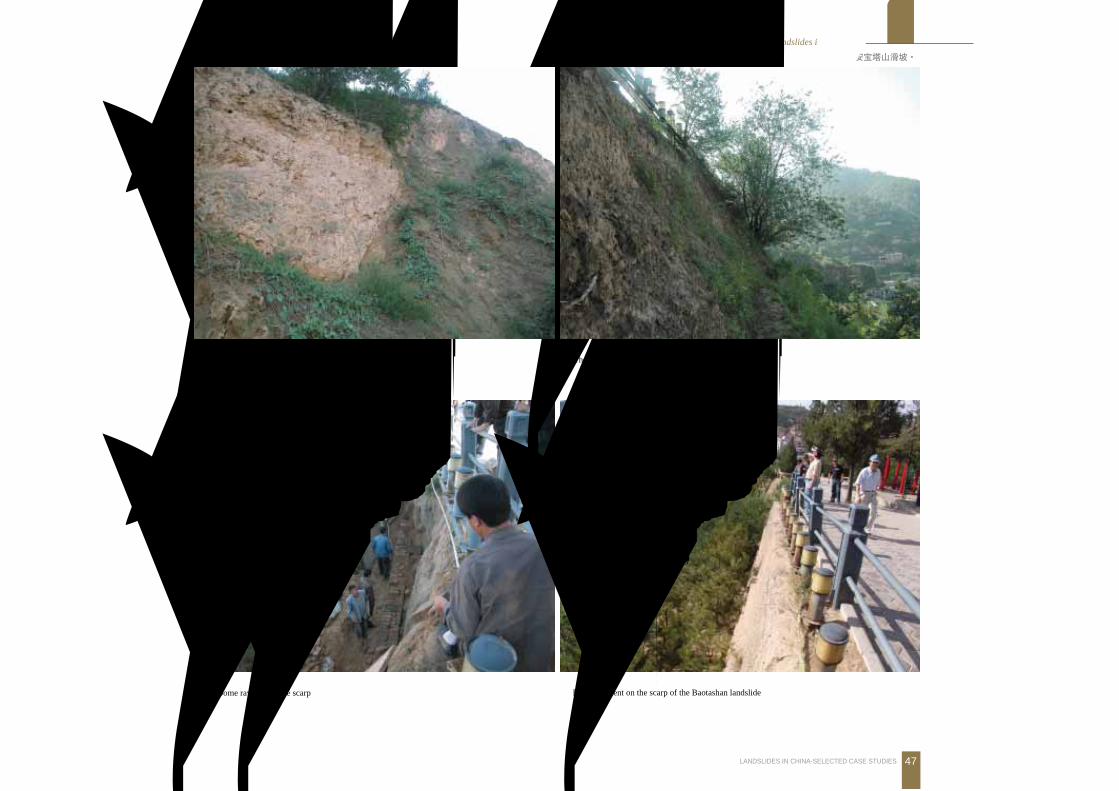
延安柳林菜秧沟黄土滑坡 (右面还分布一滑坡)Overview of one of the Caiyanggou landslides, Liulin, Yan'an City, Shaanxi Province(The other not visible, is on the opposite slope right hand side of the photo)
位于杜甫川河南岸南北向支沟菜秧沟东侧。滑坡体长
150m,宽 200m,厚 3m,体积 9万m3,为小型滑坡。底部
出露有10m厚的灰色中厚层砂岩,自上而下为晚更新世黄
土和中更新世黄土。滑坡正对面另一侧沟岸上还发育有一
相似的滑坡,其坡脚也同样存在因为建设而可能失稳问题。
The Caiyanggou landslides are located at the eastern
Caiyanggou of the Dufuchuan River. They are small landslides,
150 m long, 200 m wide, 3 m thick and 90 000 m3 in volume. The
landslides are made of Pleistocene loess. The two landslides
are unstable for slope cutting.
陕西延安柳林菜秧沟黄土滑坡Caiyanggou Landslides, Liulin, Yan'an City, Shaanxi Province
·陕西延安柳林菜秧沟黄土滑坡·

Landslides in Loess3.黄土 滑坡
49LANDSLIDES IN CHINA-SELECTED CASE STUDIES
延安川口乡偏桥滑坡远景 Overview of Pianqiao landslide of Chuankou Village, Yan'an City, Shaanxi Province
滑坡剪出口 Shear zone of landslide滑坡遥感影像 Remote sensing image showing the landslide
位于川口乡偏桥村南黄土峁北坡,长 280m,宽 800m,厚 8m,体积约 179.2万m3,属大型黄土滑坡。推测沿中更新世黄土和上三叠统瓦窑堡组
页岩,泥岩砂岩互层的接触面剪出,在滑坡前缘的出露土体中可见扰动土内卷入的与剪出口处相同的三叠统瓦窑堡组砂岩。目前该滑坡基本稳定。
This Large loess landslide is 280 m long, 800 m wide, 8 m thick and about 1.8 million m3 in volume. The shear zone is distributed between Pleistocene loess
and Triassic shale. The landslide is stable.
陕西延安川口乡偏桥滑坡Pianqiao Landslide of Chuankou Village, Yan'an City, Shaanxi Province
·陕西延安川口乡偏桥滑坡·
50 中国典型滑坡
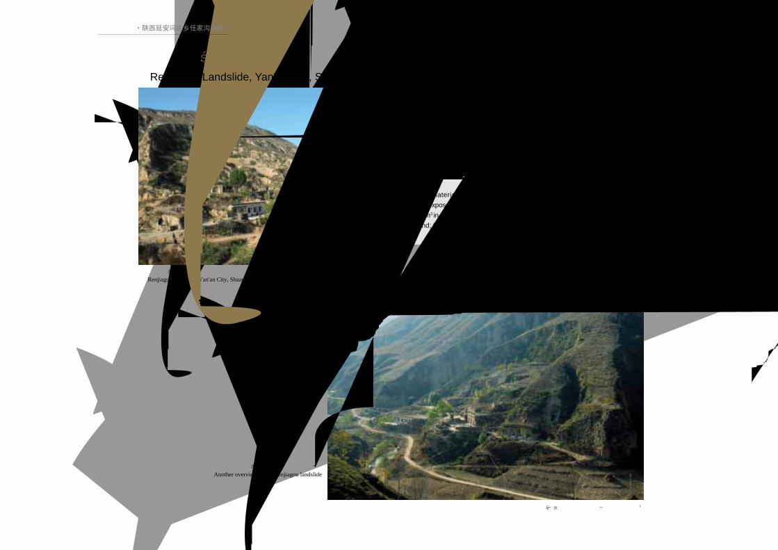
陕西延安冯庄乡任家沟滑坡
Renjiagou landslide, Yan'an City, Shaanxi Province
位于冯庄乡任家沟村。前沿地层为晚更新世黄土,未见底部基
岩出露。滑体长约 100m,宽 128m,厚约 7m,体积10万m3,后壁
呈典型的圈椅状。可见两级平台:一级平台栽种有果树;二级平台
被居民顺地势整平之后作为宅基地使用。滑体上还发育两条呈纵向
延伸的冲沟。
The material in front is Late Pleistocene loess and there is no
bedrock exposed. The landslide is 100 m long, 128 m wide, 7 m thick and
70 000 m3 in volume. There are two terraces in the back: No.1 is used for
farmland; No.2 is used for housing.
陕西延安冯庄乡任家沟滑坡远景
Another overview of the Renjiagou landslide
(本版照片由张茂省、校佩喜提供)
陕西延安冯庄乡任家沟滑坡Renjiagou Landslide, Yan'an City, Shaanxi Province
·陕西延安冯庄乡任家沟滑坡·

Landslides in Loess3.黄土 滑坡
51LANDSLIDES IN CHINA-SELECTED CASE STUDIES
陕西延安蟠龙镇李崖尧滑坡
Overview of the Liyarao landslide, Panlongzhen Village,Yan'an City, Shaanxi Province
滑坡体中有一排窑洞, 后缘壁冲沟发育Cave dwellings in the landslide
位于河谷东岸,底部出露 5m厚层砂岩,不整合
接触中更新世和晚更新世黄土,在临近河谷处夹有厚
度约 1m的河流相砾石层。后壁坡长 20m,冲沟极为
发育。滑坡长约 250m,宽 500m,厚 8m,体积约为
100m3,属大型滑坡。滑体前缘紧邻河谷,其上现住
有两户居民。目前滑体整体状况基本稳定。
The landslide is located on the eastern shore of a
river valley; 5 m of sandstone are exposed at the base.
The landslide involves Late Pleistocene loess which lies
unconformably over the sandstone. The backscar and a
system of gullies are significantly developed. The toe of
the landslide is located adjacent to the river valley.
陕西延安蟠龙镇李崖尧滑坡Liyarao Landslide, Panlongzhen Village, Yan'an City, Shaanxi Province
·陕西延安蟠龙镇李崖尧滑坡·

52 中国典型滑坡
陕西延安枣园镇芋子滩滑坡远景
Overview of the Yuzitan landslide, Yan'an City, Shaanxi Province
滑坡体中的节理 Joints in the landslide(本版照片由张茂省、校佩喜提供)
陕西延安枣园镇芋子滩滑坡Yuzitan Landslide, Zaoyuan Village, Yan'an City, Shaanxi Province
·陕西延安枣园镇芋子滩滑坡·
滑坡后部落水洞
Sinkholes in the crown oflandslide
Landslides in Loess3.黄土 滑坡
53LANDSLIDES IN CHINA-SELECTED CASE STUDIES
移民新村
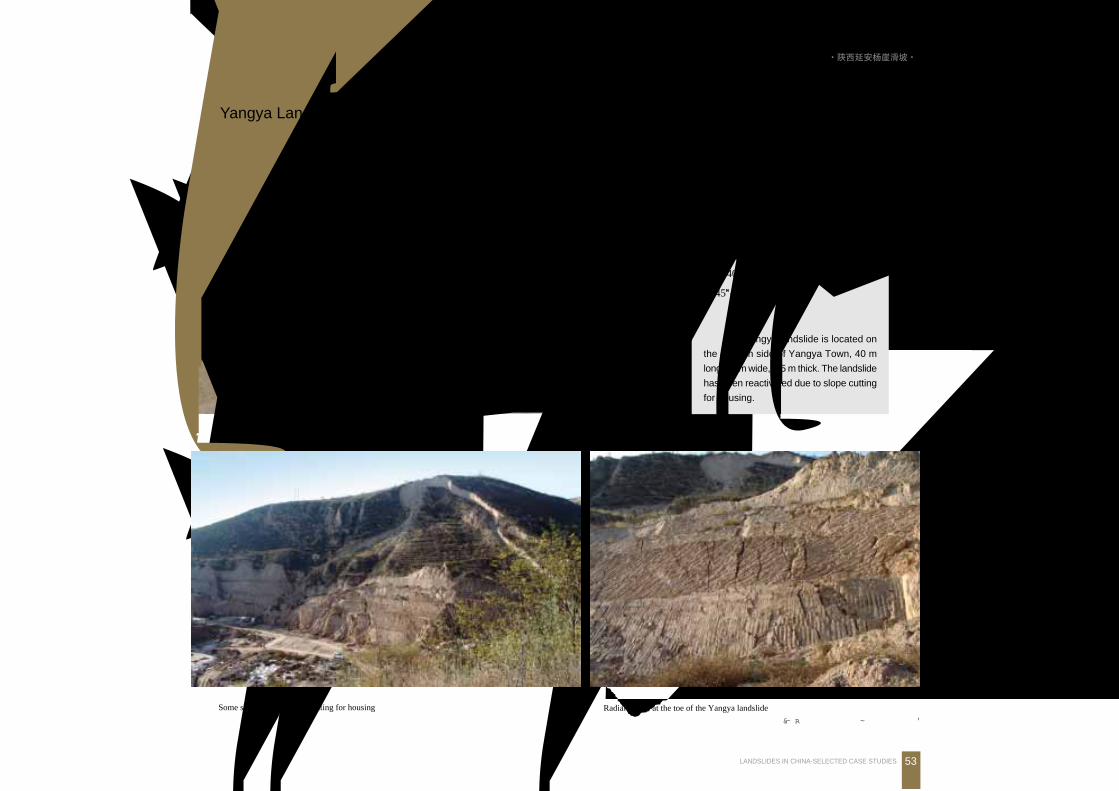
前缘场平切坡建房, 老滑坡局部滑塌Some sliding due to slope cutting for housing
新滑坡前缘纵张裂缝发育
Radial cracks at the toe of the Yangya landslide
(本版照片由张茂省、校佩喜提供)
陕西延安杨崖滑坡全景 (滑坡与移民新村、黄延高速枣园隧道)
Overview of the Yangya landslide, Yan'an City, Shaanxi Province
位于枣园镇杨崖村东侧,因公路
占地移民工程开挖坡脚而形成。滑坡
长约40m,宽约80m,厚3~5m,坡度
约45OOOOO,滑动面在原老滑坡体中的黄土
内部。
The Yangya landslide is located on
the eastern side of Yangya Town, 40 m
long, 80 m wide, 3-5 m thick. The landslide
has been reactivated due to slope cutting
for housing.
陕西延安杨崖滑坡Yangya Landslide, Yan'an City, Shaanxi Province
·陕西延安杨崖滑坡·
54 中国典型滑坡
黄土沿砂岩顶部剪
出, 滑带明显Sliding along the topof sandstone
滑坡滑带片理发育
Basal shearing andslabbing in the landslide
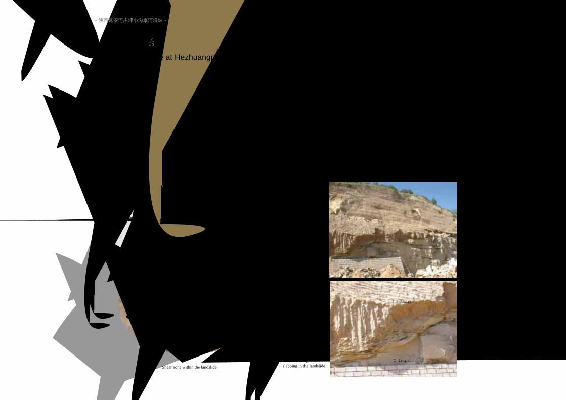
延安河庄坪小沟李河滑坡
Overview of the Lihe landslide at Hezhuangping Village, Yan'an City, Shaanxi Province
位于沟谷北侧斜坡上,原始坡度 35OOOOO,斜坡底部为
10~15m厚的厚层砂岩,自下而上有中更新世和晚更新世
黄土。滑坡体长80m,宽200m,厚5m,体积约8万m3,为
小型滑坡。在前缘边坡上可见剪节理。
滑坡体中的剪切节理
Shear zone within the landslide
Loess
Sandstone
陕西延安河庄坪小沟李河滑坡Lihe Landslide at Hezhuangping Village, Yan'an City, Shaanxi Province
·陕西延安河庄坪小沟李河滑坡·

Landslides in Loess3.黄土 滑坡
55LANDSLIDES IN CHINA-SELECTED CASE STUDIES
黄土滑塌毁坏窑洞, 17人死亡Loess fall destroyed the cave dwelling, caused 17 deaths
(本版照片由宁社教提供)
陕西延安吴旗宗湾子村石油子校黄土滑塌Shiyouzixiao Loess Fall, Zongwanzi Village, Yan'an City, Shaanxi Province
黄土滑塌毁坏窑洞
Cave dwelling destroyed by loess fall
滑塌发生于 2002年 7月 25日。滑塌体高约 20m,宽 15m,平均厚约 2m,体积约
600m3。砸毁窑洞 3孔,造成 17人死亡。被毁窑洞修建于 1992年。由于人工开挖坡
脚,盲目削坡,形成高约25m、坡度约80OOOOO的高切坡。2002年7月 24~25日的连续降
雨量高达 83mm。坡顶边缘排水渠集水及降水入渗诱发滑塌。
This fall occurred on July 25, 2002. It was about 20 m high, 15 m wide, 2 m thick and 600
m3 in volume. The cave dwelling was excavated in 1992, creating an artificial slope of 25 m high
and with a slope angle of 80O O O O O . The fall was due to heavy rainfall (83 mm) and caused 17 deaths.
·陕西延安吴旗宗湾子村石油子校黄土滑塌·
56 中国典型滑坡
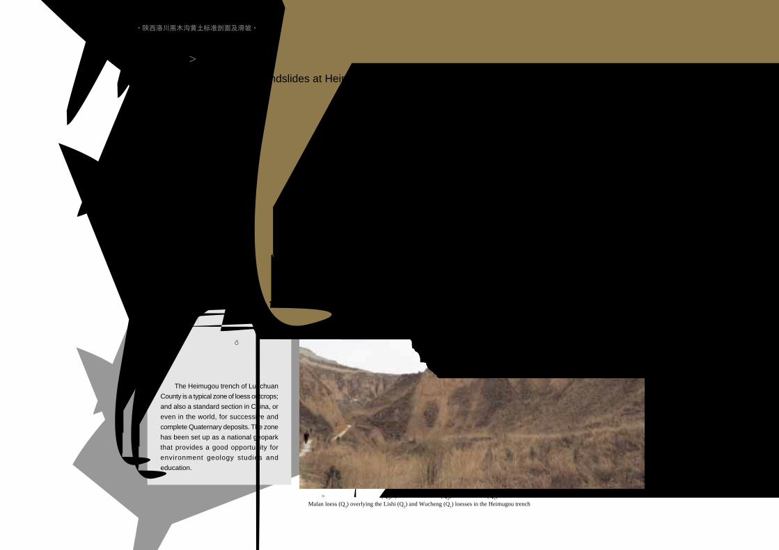
陕西洛川黑木沟马兰黄土 (Q3) 被覆在离石黄土 (Q
2) 和午城黄土 (Q
1) 之上
Malan loess (Q3) overlying the Lishi (Q
2) and Wucheng (Q
1) loesses in the Heimugou trench
陕西洛川黑木沟黄土后缘崩塌
Loess Fall in the Heimugou, LuochuanCounty, Shaanxi Province
Q3
Q2
Q1
老崩滑体
Q3
Q2
Q1
陕西洛川黑木沟出露的黄土古土
壤地层序列连续完整,是我国乃至世
界上的标准黄土地层剖面。同时,崩
塌、滑坡现象较为典型,是研究第四
纪环境及滑坡的典型地区。已被国土
资源部批准为国家地质公园。
The Heimugou trench of Luochuan
County is a typical zone of loess outcrops;
and also a standard section in China, or
even in the world, for successive and
complete Quaternary deposits. The zone
has been set up as a national geopark
that provides a good opportunity for
environment geology studies and
education.
陕西洛川黑木沟黄土标准剖面及滑坡Standard Profile and Landslides at Heimugou, Luochuan, Shaanxi Province
·陕西洛川黑木沟黄土标准剖面及滑坡·
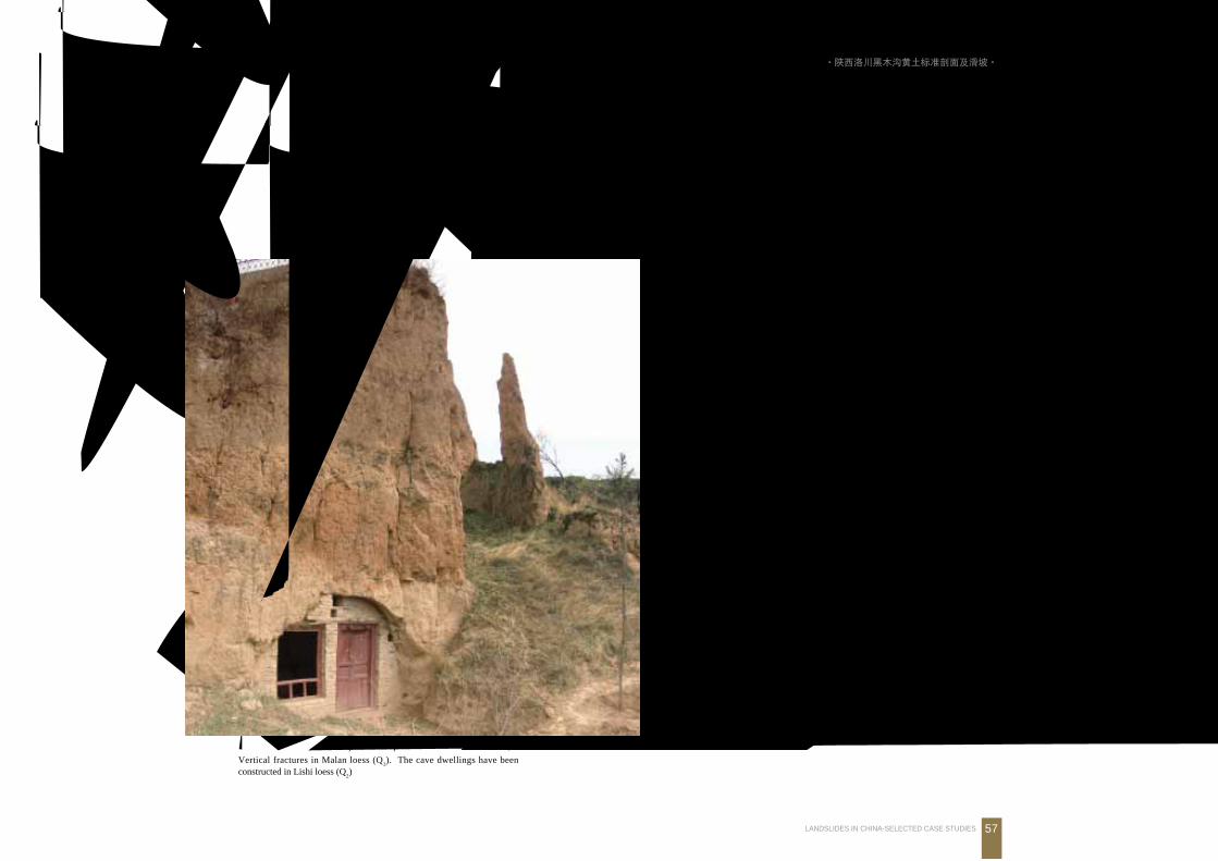
Landslides in Loess3.黄土 滑坡
57LANDSLIDES IN CHINA-SELECTED CASE STUDIES
黄土中大型节理, 溶蚀后形成溶洞Loess karst cave developed along large fractures in theHeimugou trench, Luochuan, Shaanxi Province
黄土中溶洞发育, 并在地面形成土林Loess pillars (loess “forest” ) and karstcaves, Luochuan, Shaanxi Province
马兰黄土中垂直节理发育, 稳定性差, 窑洞大多修建在离石黄土中Vertical fractures in Malan loess (Q
3). The cave dwellings have been
constructed in Lishi loess (Q2)
马兰黄土
古土壤
离石黄土
·陕西洛川黑木沟黄土标准剖面及滑坡·
58 中国典型滑坡
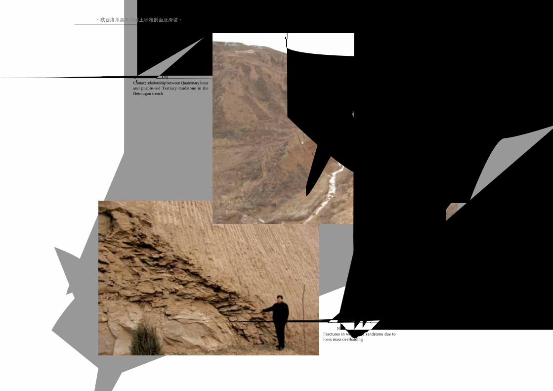
陕西洛川黑木沟第四系黄土 (Q) 与第
三系红色泥岩 (N) 接触关系Contact relationship between Quaternary loessand purple-red Tertiary mudstone in theHeimugou trench
Q
N
基岩表层风化片理发育, 在上覆黄土
重力作用下, 形成帚状破裂Fractures in weathered sandstone due toloess mass overloading
·陕西洛川黑木沟黄土标准剖面及滑坡·
Landslides in Loess3.黄土 滑坡
59LANDSLIDES IN CHINA-SELECTED CASE STUDIES
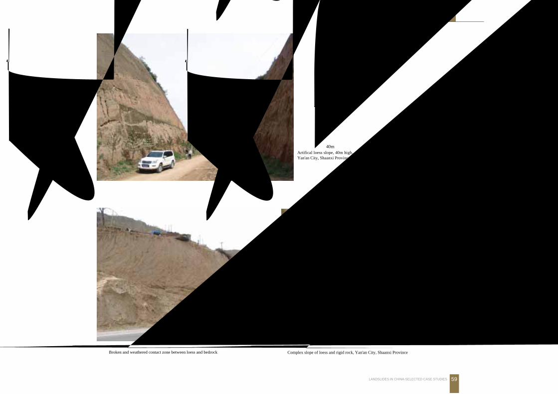
黄土与基岩接触带风化片理发育
Broken and weathered contact zone between loess and bedrock黄土与基岩复合边坡
Complex slope of loess and rigid rock, Yan'an City, Shaanxi Province
黄土边坡高达 40mArtifical loess slope, 40m high,Yan'an City, Shaanxi Province
60 中国典型滑坡
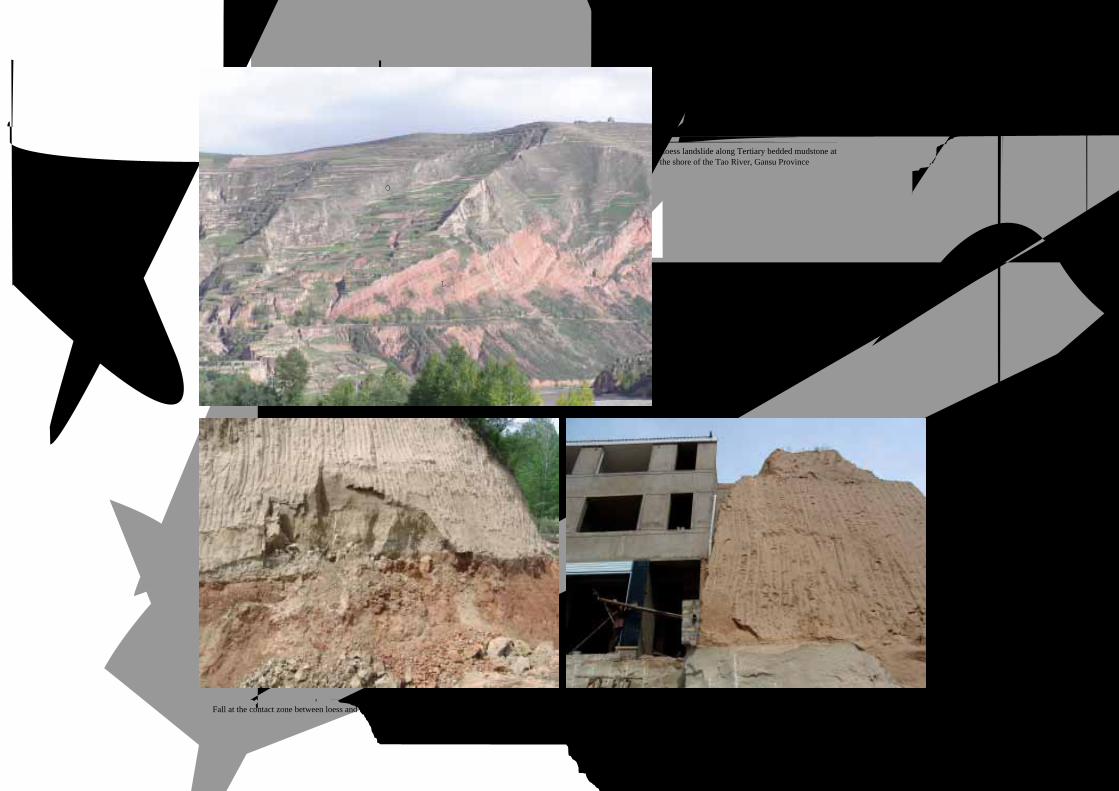
黄土与第三系红粘土接触, 上部出现崩落Fall at the contact zone between loess and red Tertiary mudstone
黄土坐落在稳定基岩平台上
Loess mass is located on stable bedrock platform
甘肃洮河岸边第四系 (Q)黄土-第三系 (N) 泥
岩顺层滑坡
Loess landslide along Tertiary bedded mudstone atthe shore of the Tao River, Gansu Province
(本照片由吴玮江提供)
Q
N

Landslides in Loess3.黄土 滑坡
61LANDSLIDES IN CHINA-SELECTED CASE STUDIES
黄土窑洞风光
Cave dwelling in loess
古黄土中的窑洞
Cave dwelling in ancient loess
兴建房屋黄土边坡滑塌
Loess fall induced by housing development黄土滑塌推压新房
Loess fall crushed new house
滑塌土体毁坏窗户
Windows damaged by fall
*本滑坡照片由张茂省提供
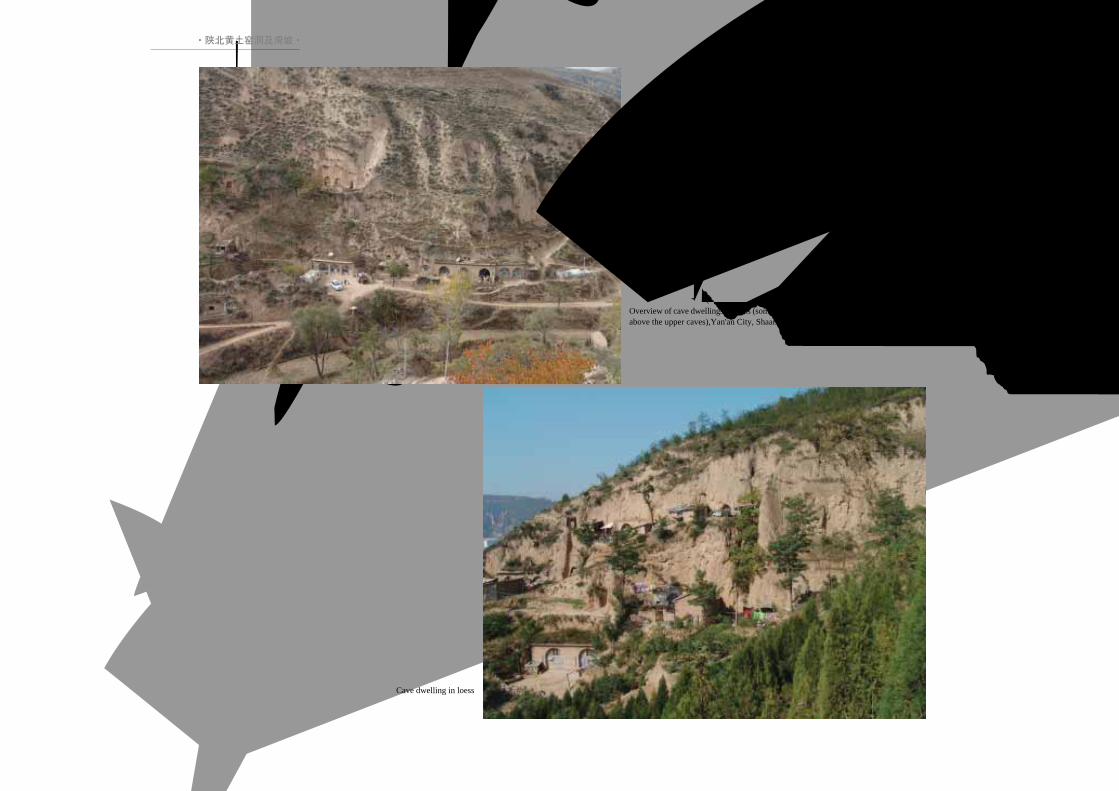
·陕北黄土窑洞及滑坡·
陕北黄土窑洞及滑坡 *
Cave Dwelling and Landslides in North Shaanxi Province
62 中国典型滑坡
黄土窑洞
Cave dwelling in loess
黄土中的窑洞远景 (上部窑洞出现裂缝)Overview of cave dwellings in loess (some fractures occurredabove the upper caves),Yan'an City, Shaanxi Province
·陕北黄土窑洞及滑坡·
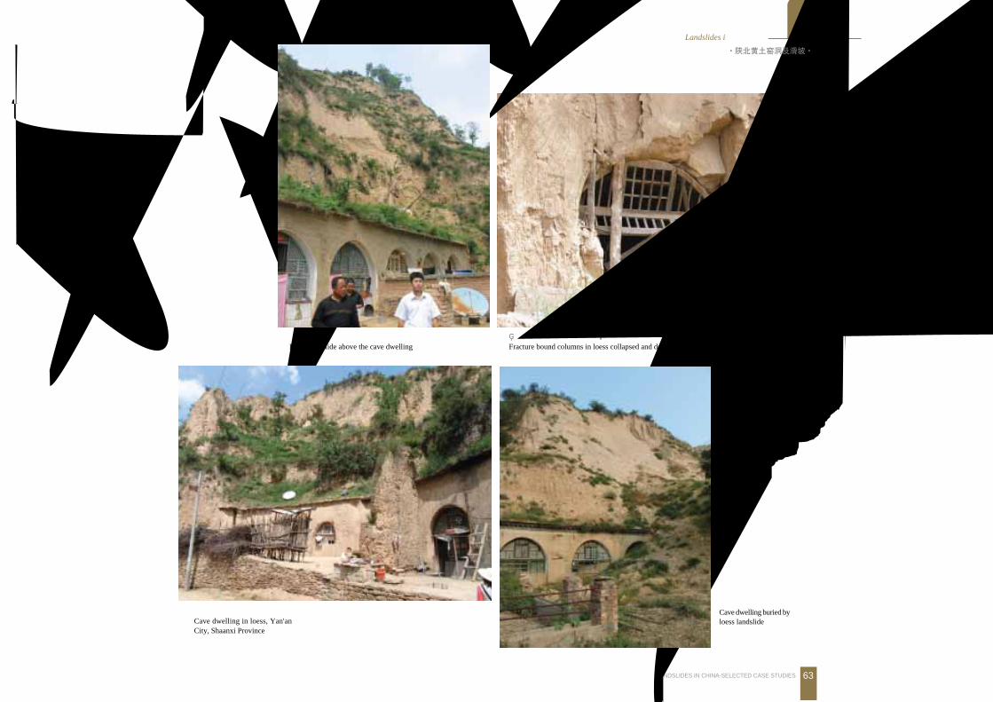
Landslides in Loess3.黄土 滑坡
63LANDSLIDES IN CHINA-SELECTED CASE STUDIES
被节理切割的黄土柱下座, 毁坏窑洞Fracture bound columns in loess collapsed and destroyed the dwelling
滑坡掩埋窑洞
Cave dwelling buried byloess landslide
窑洞上部的黄土滑坡
Loess landslide above the cave dwelling
黄土窑洞
Cave dwelling in loess, Yan'anCity, Shaanxi Province
·陕北黄土窑洞及滑坡·

·新疆伊犁新源巴特巴克特萨依沟滑坡泥石流·
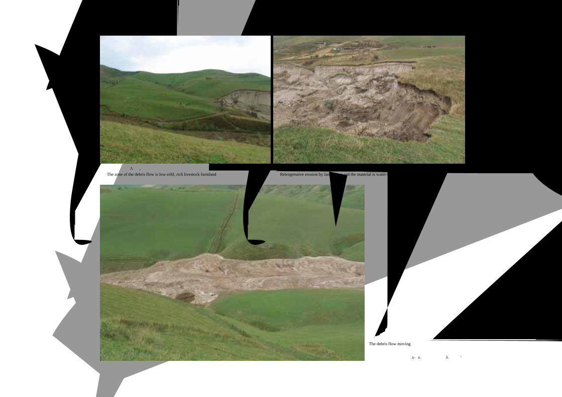
64 中国典型滑坡
新疆伊犁新源巴特巴克特萨依沟滑坡泥石流Tesayigou Slide/debris-flow in Xinyuan County, Xinjiang
滑坡溯源侵蚀, 向下形成转化泥石流Retrogressive landslide converting into debris flow, Xinyuan County, Xinjiang
为复合类型,由滑坡转化为泥石流,发生于 2005年 6月 12日。距沟口 2.3km泉水溢出带东侧山体发生滑坡,沟谷内分布较
多沼泽湿地,滑坡移动沿途两岸产生滑坡、崩塌的物质与沟谷中大量淤泥汇入形成泥石流。泥石流堆积体长约 2.5km,土方量约
1520万m3。滑坡-泥石流区地势平坦。下伏古生界石炭系火山碎屑岩,上部表层覆盖第四系黄土。沟谷上游泉水出露较多,滑
坡体位于泉水溢出带,受冬季融雪和降水多次发生滑坡,土体饱水,呈液化状态,滑动中带动两侧沟岸产生次级崩塌、滑坡并带动
沟谷内大量淤泥汇入形成泥石流。泥石流速度一般为 4~10m/h。
This complex slope movement began as a slide and became debris flow. It occurred on June 12, 2005. The landslide started at a spring
discharge zone. The debris flow has a length of 2.5 km, 15.2 million m3 in total volume. It developed swamps and induced lots of secondary
landslides. The complex landslide involved Quatenary loess resting on clastic sedimentary rock of Caboniferous age.

·新疆伊犁新源巴特巴克特萨依沟滑坡泥石流·
Landslides in Loess3.黄土 滑坡
65LANDSLIDES IN CHINA-SELECTED CASE STUDIES
巴特巴克特萨依沟滑坡转化为泥石流全景图 [由东向西拍
摄, 泥石流由北向南 (右向左)运动, 全长 2.5km]Overview of mudslide converting into mudflow, with a length of2.5 km, Xinyuan, Xinjiang
(本版照片由宫小平提供)
泥石流铲动沟谷两侧形成滑坡
Secondary landslides induced at the two sides of the debris flow
泥石流堆积区前缘
The toe zone of earth flow
泥石流中部流通—堆积区 (由西北向东南拍摄)The debris flow moving through different topography
·新疆伊犁新源巴特巴克特萨依沟滑坡泥石流·
66 中国典型滑坡
滑坡区地势平缓, 是良好的牧场The zone of the debris flow is low-relif, rich livestock farmland
滑坡逐渐向源掏蚀, 物源区土体结构均匀、富水Retrogressive erosion by landslding and the material is water-bearing
泥石流呈塑性流动
The debris flow moving
(本版照片由宫小平提供)

·新疆伊犁新源加郎普特滑坡·
Landslides in Loess3.黄土 滑坡
67LANDSLIDES IN CHINA-SELECTED CASE STUDIES
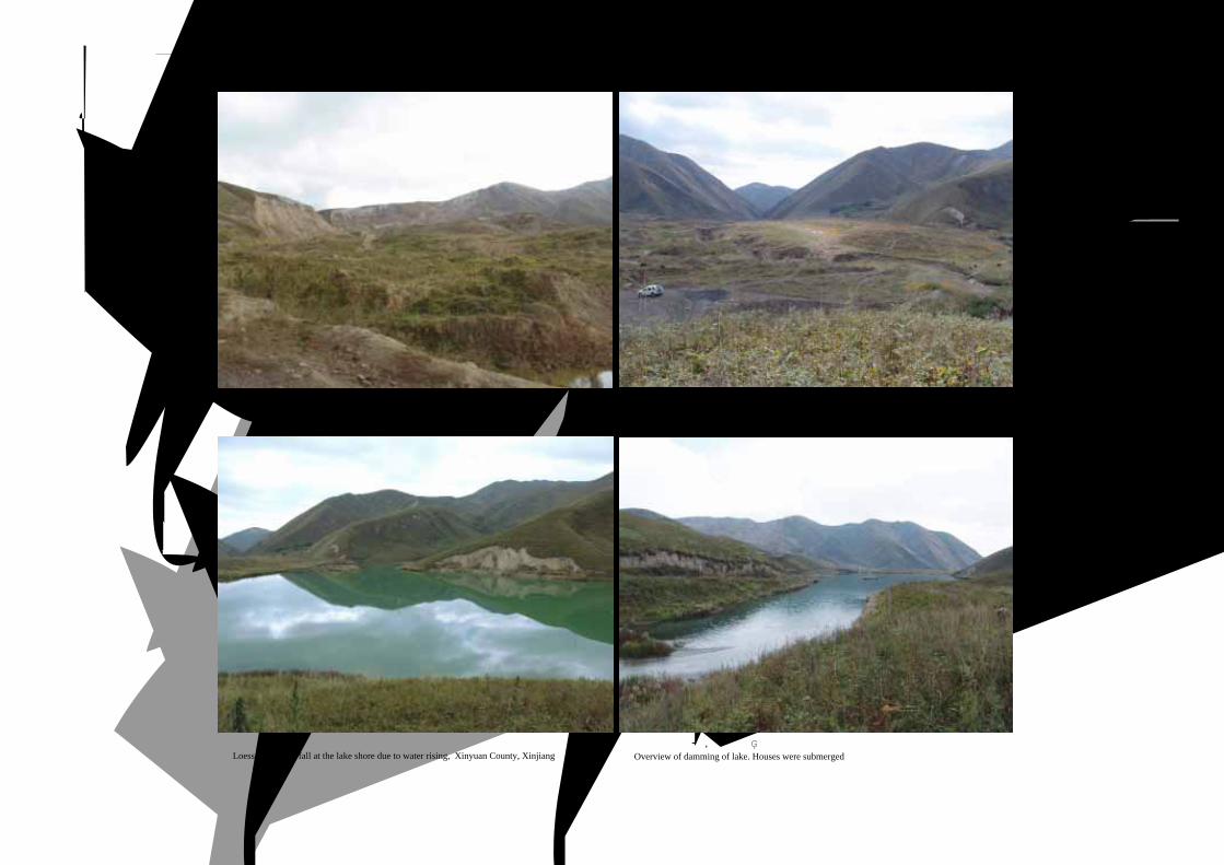
新疆伊犁新源加郎普特滑坡Jialangpute Landslide in Xinyuan County, Yili City, Xinjiang
滑坡及堰塞湖全景
Overview of the Jialangpute landslide and damming of lake, Xinyuan County, Xinjiang
滑坡后缘及黄土与基岩接触全景
Landslide scarp showing the contact between loess and bedrock(本照片由宫小平提供)
滑坡发生于 2003年 5月 11日,为黄土滑坡。滑坡东西长约 1km,南北最大宽度约 0.6km,面积 66万m2,体积约 960万m3。滑坡
由东向西进入主沟转向南顺则克台沟向下移动近 6km,在主沟内形成高 815m、宽 80 120m的堆积物。滑坡体堵塞河流形成水面面积
为 11万m2、最大水深达 13m、蓄水量约 90万m3的滑坡堰塞湖。滑坡后壁高 40~90m,下方有多处泉水出露,下部出露有棕黄色泥
岩和砾岩。黄土与下伏基岩之间的不整合面构成现代滑坡的滑动面。
This landslide occurred on May 11, 2003; it is 1000 m long (EW), 600 m wide (NS) and is 9.6 million m3 in volume. The accumulation lobe of
the loess landslide dammed a river and a lake was formed with a storage of 900 thousand m3 and a depth of 3 m. The main scarp is 40-90 m high
and there are springs at the bottom of the scarp.
·新疆伊犁新源加郎普特滑坡·
68 中国典型滑坡
堰塞湖岸边形成黄土滑塌
Loess slump and fall at the lake shore due to water rising, Xinyuan County, Xinjiang滑坡堰塞湖全景, 湖中房屋被淹Overview of damming of lake. Houses were submerged
滑坡体中后部堆积物质主要为黄土
The crown scarp, the back and the mid-sections of the landslide are loess
滑坡坝中部形成冲沟, 为湖水下泄通道Trench in the Jialangpute landslide dam
Landslides in Loess3.黄土 滑坡
69LANDSLIDES IN CHINA-SELECTED CASE STUDIES
新疆伊犁巩留浅层黄土滑坡和泻流
Loess landsliding in Gongliu County, Yili City, Xinjiang
新疆伊犁巩留黄土滑坡, 由披覆在基岩山
地的第四系风成黄土构成
Quatenary loess landsliding in Gongliu County,Yili City, Xinjiang
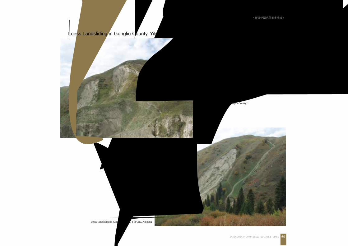
新疆伊犁巩留黄土滑坡Loess Landsliding in Gongliu County, Yili City, Xinjiang
·新疆伊犁巩留黄土滑坡·
70 中国典型滑坡
4.风化层与堆积层滑坡
Landslides in Weatheredand Colluvial Materials
LANDSLIDES IN WEATHERED AND COLLUVIAL MATERIALS
LANDSLIDES IN WEATHERED AND COLLUVIAL MATERIALS
LANDSLIDES IN WEATHERED AND COLLUVIAL MATERIALS
4.风化层与堆积层 滑坡Landslides in Weathered and Colluvial Materrrials
71LANDSLIDES IN CHINA-SELECTED CASE STUDIES
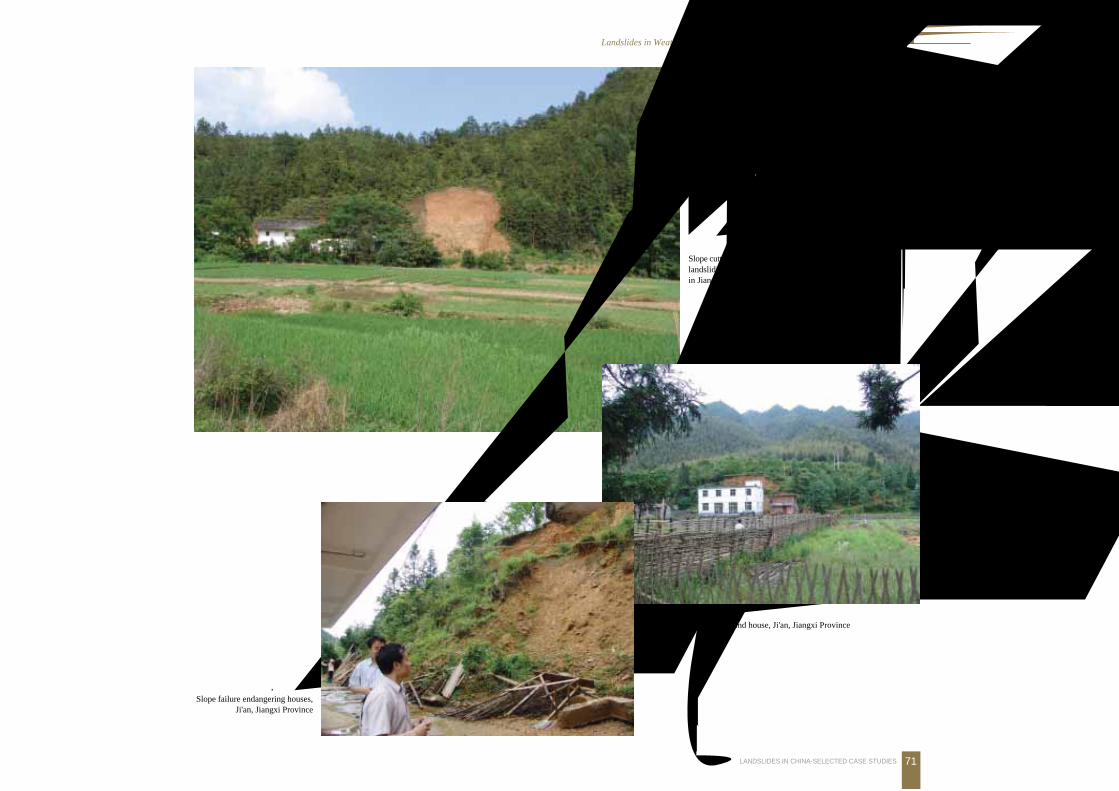
农村居民切坡建房, 上部风化带富水, 边
坡稳定性差
Slope cutting by housing development inducedlandsliding of water-rich weathered materialsin Jiangxi Province
农村民房后坡失稳滑塌
Landslide behind house, Ji'an, Jiangxi Province
边坡未加防护, 危及民房Slope failure endangering houses,
Ji'an, Jiangxi Province
72 中国典型滑坡
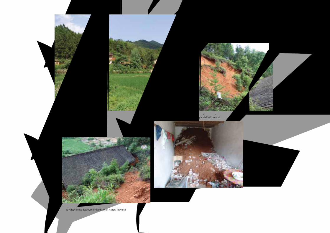
农村民房后坡滑塌
Landslide behind a house, Jiangxi Province切坡未加支护, 风化强烈, 稳定性差Slope sliding in residual material
滑坡毁坏民房
A village house destroyed by landslide in Jiangxi Province
滑坡冲入民房
Landslide crashed into the house
4.风化层与堆积层 滑坡Landslides in Weathered and Colluvial Materrrials
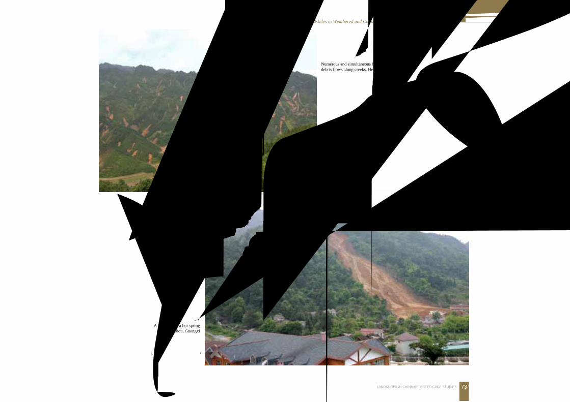
73LANDSLIDES IN CHINA-SELECTED CASE STUDIES
广西贺州金秀土石碎屑流
Numerous and simultaneous hill slides that generateddebris flows along creeks, Hezhou, Guangxi
广西贺州温泉景区滑坡
A landslide at a hot springresort, Hezhou, Guangxi
(本版照片由何小明提供)
74 中国典型滑坡
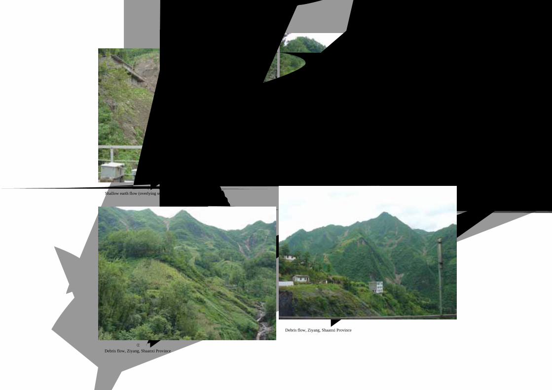
陕西紫阳浅表层土流 (下伏板岩、千枚岩)Shallow earth flow (overlying schist) Ziyang, Shaanxi Province
陕西紫阳浅表层土流隐患区
Potential hazard of shallow earth flows, Ziyang, Shaanxi Province
陕西紫阳碎屑流-泥石流
Debris flow, Ziyang, Shaanxi Province
陕西紫阳浅表碎屑流
Debris flow, Ziyang, Shaanxi Province
4.风化层与堆积层 滑坡Landslides in Weathered and Colluvial Materrrials
75LANDSLIDES IN CHINA-SELECTED CASE STUDIES
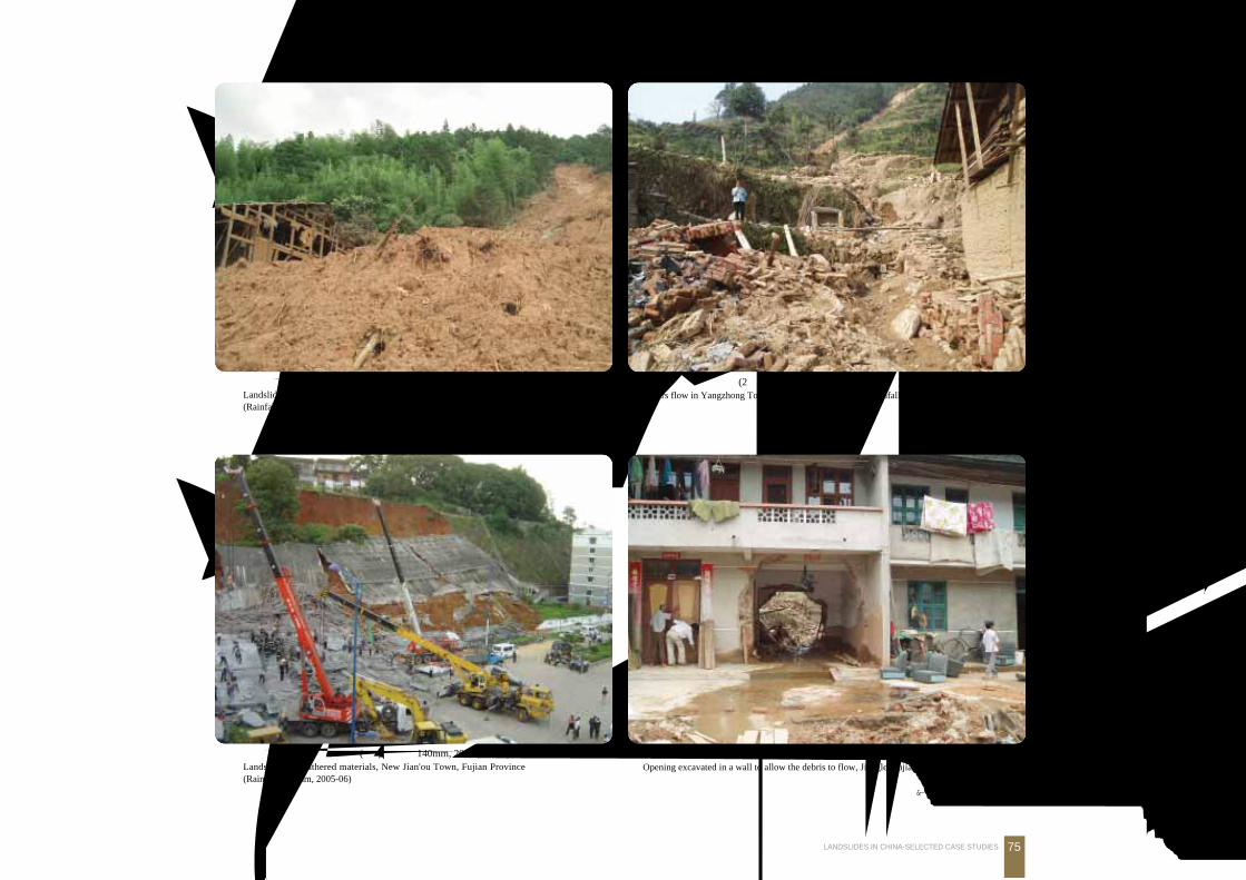
福建顺昌际会乡坡积层滑坡 (累计降雨量 520mm, 2005年 6月)Landslide in weathered materials, Jihui Village, Shunchang, Fujian Province(Rainfall 520 mm, 2005-06)
福建宁德洋中镇泻流 (2小时降雨量 300mm, 2005年 10月)Debirs flow in Yangzhong Town, Ninde, Fujian Province (Rainfall 300 mm in 2 hours, 2005-10 )
福建建瓯新区坡积层滑坡 (累计降雨量 140mm, 2005年 6月)Landslide in weathered materials, New Jian'ou Town, Fujian Province(Rainfall 140 mm, 2005-06)
福建将乐大源乡泥石流 (占道行洪区的房屋不得不开通出口, 2005年 6月)Opening excavated in a wall to allow the debris to flow, Jiangle, Fujian Province (2005-06)
(本版照片由何永金提供)
76 中国典型滑坡
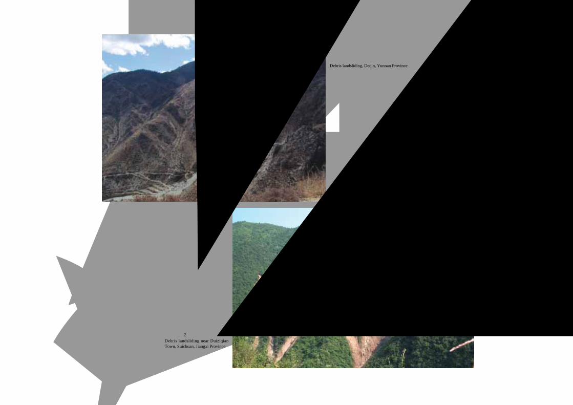
云南德钦碎屑流
Debris landsliding, Deqin, Yunnan Province
江西遂川堆子前镇碎屑流
Debris landsliding near DuiziqianTown, Suichuan, Jiangxi Province
4.风化层与堆积层 滑坡Landslides in Weathered and Colluvial Materrrials
77LANDSLIDES IN CHINA-SELECTED CASE STUDIES
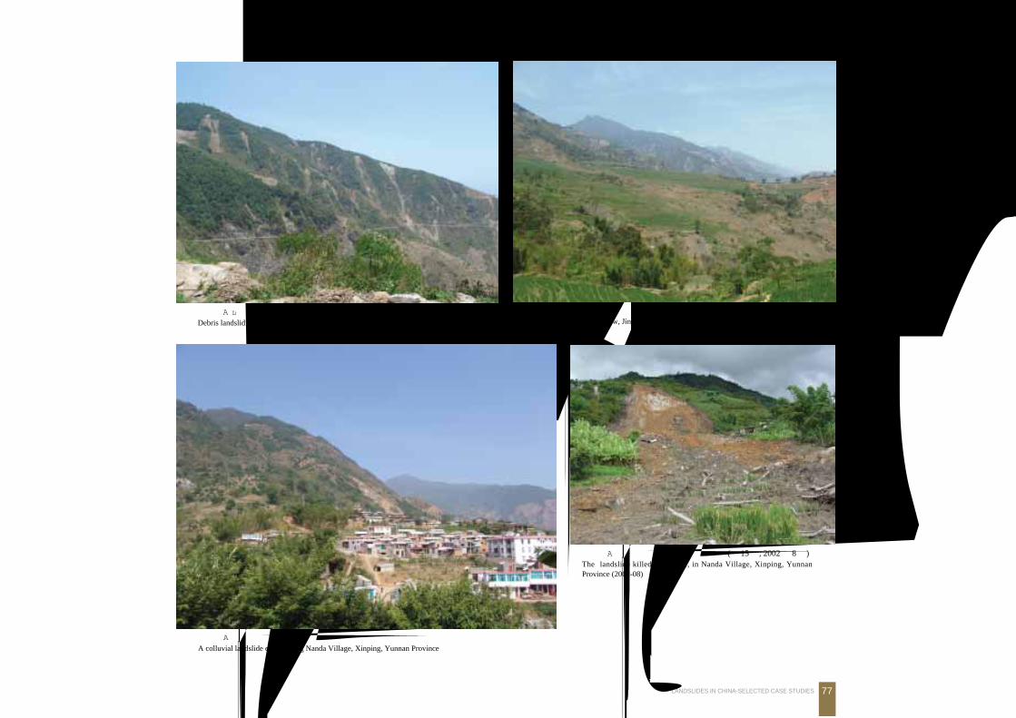
云南新平哀牢山碎屑流
Debris landsliding near Ailao Mt., Xinping, Yunnan Province
云南新平水塘镇金厂村芭蕉树滑坡 (转变为泥石流)Sliding becoming debris flow, Jingchang Village, Xinping, Yunnan Province
云南新平水塘镇南达村后山坡积层滑坡危及村庄
A colluvial landslide endangering Nanda Village, Xinping, Yunnan Province
云南新平水塘镇南达村后山坡积层滑坡 (死 15人, 2002年 8月)The landslide killed 15 people, in Nanda Village, Xinping, YunnanProvince (2002-08)
78 中国典型滑坡
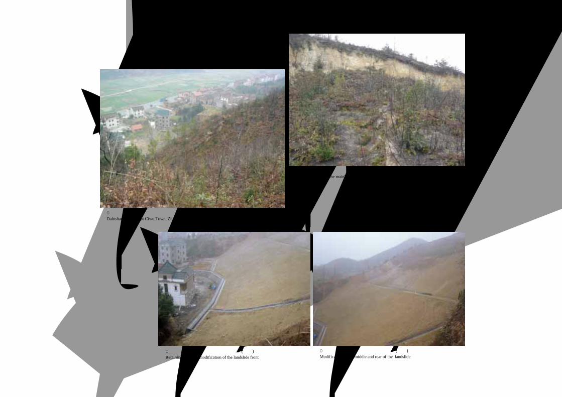
浙江诸暨次钨镇大路山滑坡
Dalushan landslide at Ciwu Town, Zhuji City, Zhejiang Province
浙江诸暨次钨镇大路山滑坡后缘整体下座
The scarp showing the mainbody displacement
浙江诸暨次钨镇大路山滑坡治理工程 (前部)Retaining wall and modification of the landslide front
浙江诸暨次钨镇大路山滑坡治理工程 (后部)Modification of the middle and rear of the landslide
4.风化层与堆积层 滑坡Landslides in Weathered and Colluvial Materrrials
79LANDSLIDES IN CHINA-SELECTED CASE STUDIES
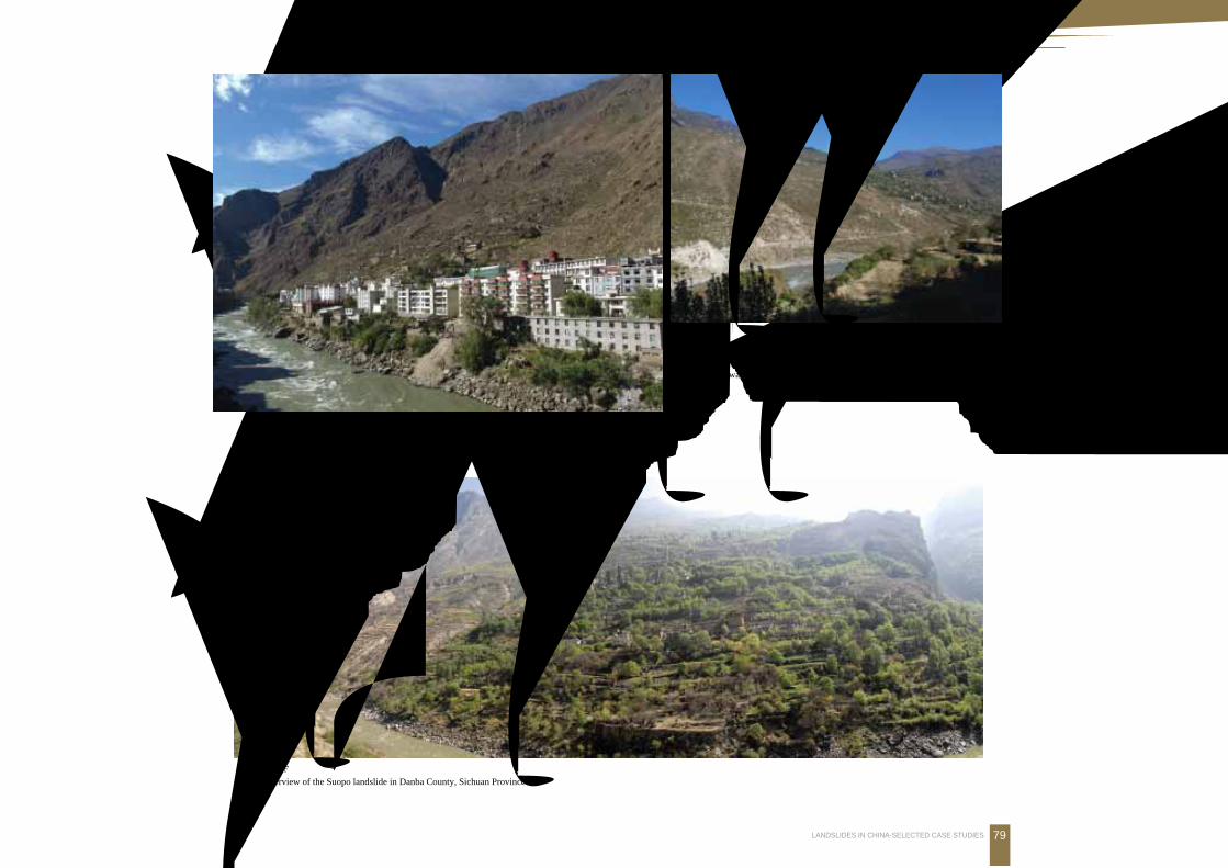
亚喀则滑坡
梭坡滑坡
大 渡 河
丹巴梭坡滑坡, 位于大渡河左岸, 滑坡体上碉
楼出现倾斜, 局部出现后缘贯通错落Suopo landslide on the left shore of the Daduhe River.Ancient watchtowers are tilting and sliding
亚喀则滑坡梭坡滑坡
丹巴红军桥堆积层滑坡
Hongjunqiao colluvial landslide in DanbaCounty, Sichuan Province
丹巴梭坡滑坡全景
Overview of the Suopo landslide in Danba County, Sichuan Province

80 中国典型滑坡
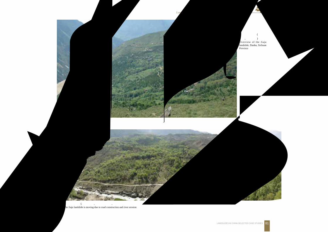
甲居滑坡前缘堆积体
Accumulation zone, Jiaju landslide
丹巴美人谷甲居藏寨坐落在滑坡体上
The Tibetan Jiaju village is located on the Jiaju landslidein the Meiren valley of Danba County, Sichuan Province
甲居滑坡前缘及大渡河上游之金河
The Jiaju landslide is on the shore of Jinghe River, a branch of the Daduhe River
美丽的甲居藏楼
Beautiful Tibetan village house on the Jiaju landslide
4.风化层与堆积层 滑坡Landslides in Weathered and Colluvial Materrrials
81LANDSLIDES IN CHINA-SELECTED CASE STUDIES
甲居滑坡全貌 (镜头朝
南东, 金河下游)Overview of the Jiajulandslide, Danba, SichuanProvince
甲居滑坡前缘被江水淘刷, 加上公路开挖, 稳定性差The Jiaju landslide is moving due to road construction and river erosion
82 中国典型滑坡
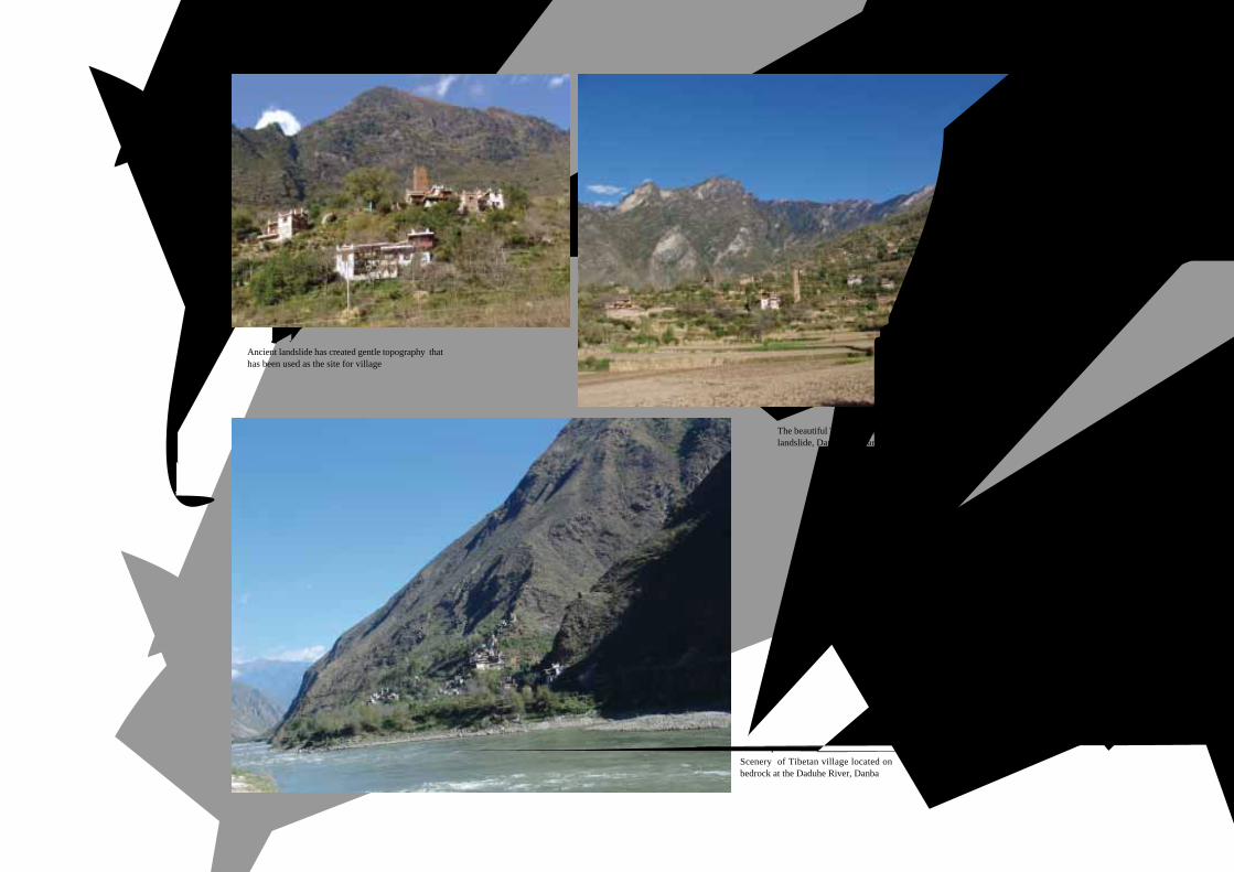
滑坡体常成为居住场地
Ancient landslide has created gentle topography thathas been used as the site for village
中路乡美丽的藏寨坐落在古滑坡体上
The beautiful Tibetan village is situated on ancientlandslide, Danba, Sichuan Province
位于大渡河上游边的丹巴美人谷藏
寨楼群, 坐落在基岩上Scenery of Tibetan village located onbedrock at the Daduhe River, Danba
4.风化层与堆积层 滑坡Landslides in Weathered and Colluvial Materrrials
83LANDSLIDES IN CHINA-SELECTED CASE STUDIES
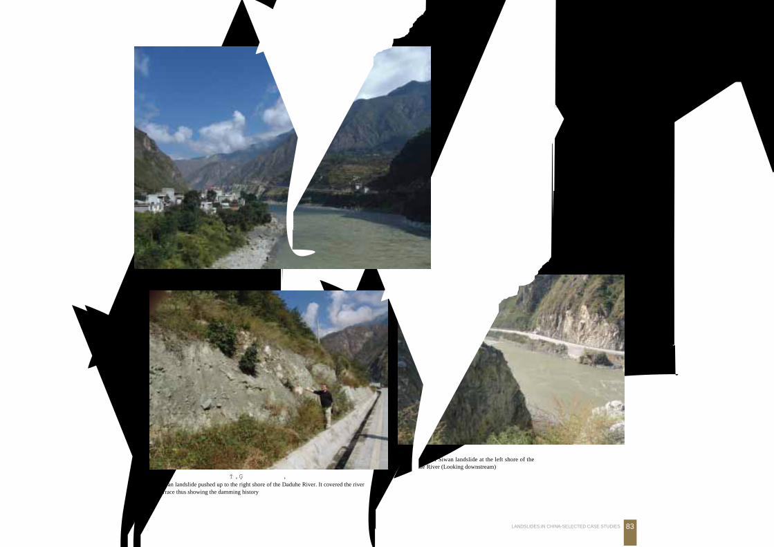
四湾滑坡前缘堆积体及大渡河
The front of Siwan landslide at the left shore of theDaduhe River (Looking downstream)
位于四川泸定桥上游 1.5 km大渡河左岸的四湾
滑坡, 体积近 1亿m3
Siwan landslide, 100 million m3, on the left shore of theDaduhe River, 1.5 km upstream from the Luding bridge,Sichuan Province (Looking upstream)
四湾滑坡滑冲到大渡河右岸, 被一级阶地超覆, 显示曾发生堵江事件Siwan landslide pushed up to the right shore of the Daduhe River. It covered the riverterrace thus showing the damming history
泸 定
河
渡
大
古滑坡体
四湾古滑坡
大
渡
河
84 中国典型滑坡
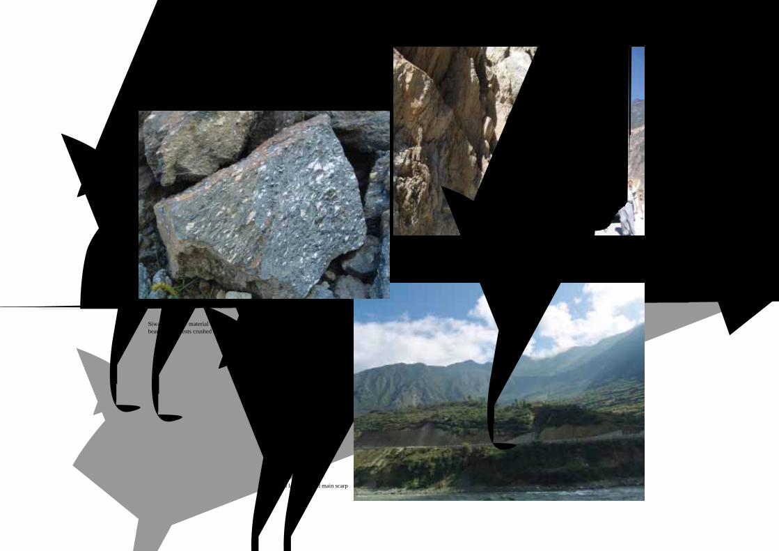
四湾滑坡及后缘滑床
Siwan landslide and main scarp
四湾滑坡原岩为二云片岩, 富含石榴子石, 受构
造强烈挤压, 较为光滑Siwan landslide material consists of garnet and mica-bearing fragments crushed by tectonic processing
大渡河上游分布的二云片岩形成易滑地层
Mica schist widely distributed in the upper reaches of theDaduhe River that is prone to sliding
古滑坡床


![Wei Li , Ying Liu , Quan Luo , Xue-Mei Li , Xi-Bao Zhang · 2018-11-05 · epidermal growth factor (EGF) and heparin-binding-EGF induced cell proliferation [4,5]. b. Retinoids increases](https://img.pdfslide.tips/doc/110x75/5f0a1d4d7e708231d42a14fb/wei-li-ying-liu-quan-luo-xue-mei-li-xi-bao-zhang-2018-11-05-epidermal.jpg)