Embed Size (px)
Citation preview

ELSEVIER Sedimentary Geology 123 (1999) 239–254
A paleo-Brahmaputra? Subsurface lithofacies analysis of Miocenedeltaic sediments in the Himalayan–Bengal system, Bangladesh
Ashraf Uddin a,b,Ł, Neil Lundberg a
a Department of Geology, Florida State University, Tallahassee, FL 32306, USAb National High Magnetic Field Laboratory, Florida State University, Tallahassee, FL 32306, USA
Received 30 January 1998; accepted 22 September 1998
Abstract
The Bengal foreland basin contains a succession of up to 16C km of dominantly deltaic deposits, eroded from theeastern Himalayas and the Indo–Burman ranges and carried by major river systems similar to the present-day Gangesand Brahmaputra. Analysis of electric logs and core descriptions acquired during oil and gas exploration in Bangladeshallows construction of lithofacies maps, which constrain depositional patterns of Miocene strata. Compilations of sandthickness and sand=shale ratio of the Miocene Surma Group show that Lower to Middle Miocene strata of the BhubanFormation accumulated in a large, elongate trough. Sand thickness and percentage both decrease markedly away from thisdepocenter, which describes a large-scale bend, running initially westward from Rashidpur (northeast Bengal basin) andcurving southward toward the Bengal fan. Middle to Upper Miocene strata of the Boka Bil Formation show a similargeographic trend in deposition of coarsest and thickest sediment, but the major depocenter had shifted northward relativeto that of the Bhuban Formation by some 30 km, passing near Beani Bazar. These trends suggest that deltaic deposits ofthe Surma Group filled the Sylhet trough of the northeast Bengal basin from the east. Published seismic data from westernBangladesh show that additional large channels also contributed materials to the Bengal basin from the northwest duringthe Late Miocene, but these channels resulted in very little accumulation in the northwestern part of the basin, probablydue to restricted subsidence of underlying continental crust. This study suggests that there was a major drainage systemsimilar to the modern Brahmaputra River during Miocene time, which carried orogenic sediments eroded from the upliftedterranes of the eastern Himalayas and Indo–Burman ranges to the eastern Bengal delta. 1999 Elsevier Science B.V. Allrights reserved.
Keywords: Bangladesh; deltaic sedimentation; electric logging; Himalayas; lithofacies; paleogeography
1. Introduction
The Bengal basin of Bangladesh includes one ofthe largest delta complexes in the world, covering anarea of more than 200,000 km2 with a sedimentary
Ł Corresponding author. Tel.: C1 (850) 644-5860; Fax: C1 (850)644-4214; E-mail: [email protected]
fill that is more than 16 km thick (Hiller and Elahi,1984; Reimann, 1993). It is filled mainly by oro-genic sediment derived from the eastern Himalayasto the north and the Indo–Burman ranges to the east(Fig. 1). These deposits record uplift and exhuma-tion of mountain belts formed by the ongoing India–Eurasia collision. The bulk of the deltaic deposits areMiocene and younger (Fig. 2). Upper Eocene and
0037-0738/99/$ – see front matter 1999 Elsevier Science B.V. All rights reserved.PII: S 0 0 3 7 - 0 7 3 8 ( 9 8 ) 0 0 1 3 4 - 1

240 A. Uddin, N. Lundberg / Sedimentary Geology 123 (1999) 239–254
Fig. 1. Map showing major tectonic elements of the Bengal basin. This map also shows location of wells for which geophysical datawere analyzed in this study, and locations of outcrop stratigraphic sections depicted in Fig. 3. Hinge zone separates shallow Indianplatform from the thick Bengal foreland basin and eastern fold belt. Abbreviations: DF D Dauki fault; IC D Indian craton; MH D MikirHills.
Oligocene sediments comprise relatively thin mud-stone and quartzose sandstone units derived mainlyfrom cratonic sources of the Indian block (Uddin and
Lundberg, 1998a). Miocene sediments of the SurmaGroup, however, consisting of the Early to MiddleMiocene Bhuban Formation and the Middle to Late
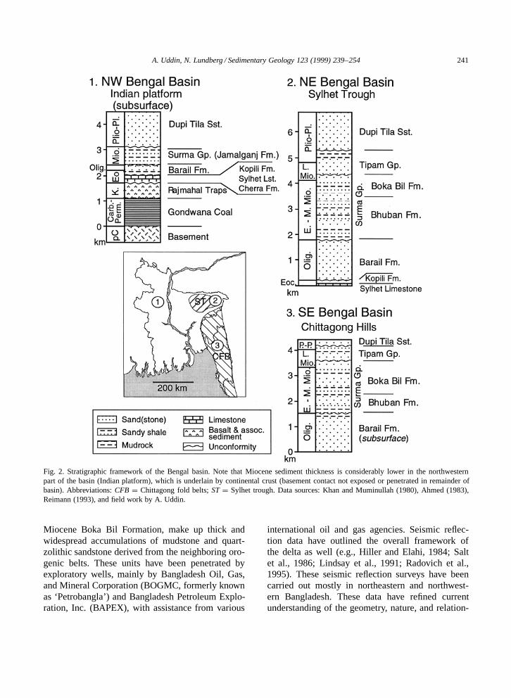
A. Uddin, N. Lundberg / Sedimentary Geology 123 (1999) 239–254 241
Fig. 2. Stratigraphic framework of the Bengal basin. Note that Miocene sediment thickness is considerably lower in the northwesternpart of the basin (Indian platform), which is underlain by continental crust (basement contact not exposed or penetrated in remainder ofbasin). Abbreviations: CFB D Chittagong fold belts; ST D Sylhet trough. Data sources: Khan and Muminullah (1980), Ahmed (1983),Reimann (1993), and field work by A. Uddin.
Miocene Boka Bil Formation, make up thick andwidespread accumulations of mudstone and quart-zolithic sandstone derived from the neighboring oro-genic belts. These units have been penetrated byexploratory wells, mainly by Bangladesh Oil, Gas,and Mineral Corporation (BOGMC, formerly knownas ‘Petrobangla’) and Bangladesh Petroleum Explo-ration, Inc. (BAPEX), with assistance from various
international oil and gas agencies. Seismic reflec-tion data have outlined the overall framework ofthe delta as well (e.g., Hiller and Elahi, 1984; Saltet al., 1986; Lindsay et al., 1991; Radovich et al.,1995). These seismic reflection surveys have beencarried out mostly in northeastern and northwest-ern Bangladesh. These data have refined currentunderstanding of the geometry, nature, and relation-

242 A. Uddin, N. Lundberg / Sedimentary Geology 123 (1999) 239–254
ships between different tectonic domains. Analysisof these seismic data has also led to interpretationsof paleogeography and sedimentation patterns of thedelta.
Despite its size and record of collisional history,the Ganges=Bengal delta has not been studied indetail compared to other major deltas. Even the off-shore equivalent strata in the Bengal deep-sea fanhave been studied more intensively (e.g., Naini andLeyden, 1973; Curray, 1994). The basin is rich inhydrocarbons, with estimated reserves of 400 billionm3 of natural gas and 40 million barrels of con-densate. Studies of the Miocene deltaic sedimentsto date have largely focused on hydrocarbon po-tential (i.e., Brunnschweiler, 1980; Lietz and Kabir,1982); in contrast, processes of deltaic sedimentationand Miocene paleogeography have not yet been welldocumented.
In this study, subsurface lithofacies maps ofthe Miocene Surma Group have been constructed,based on analysis of geophysical logs from wellsin Bangladesh. These data are used to constraindepositional patterns of deltaic strata in the Ben-gal basin. These data have also allowed us to tracea Miocene major drainage system developed as aresult of orogenic uplift of the eastern Himalayasand the Indo–Burman ranges. This paleogeographicinformation, in addition to being useful for hydro-carbon exploration, can provide constraints on thegeomorphic evolution of the developing foreland inthe least-known part of the Himalayan system.
2. Bengal basin
The Bengal basin has developed largely over aremnant-ocean basin and the rifted eastern conti-nental margin of India (Graham et al., 1975), withcontinental crust underlying at least the northwesternportion of Bangladesh (Khan and Agarwal, 1993).The basin extends southward into the Bay of Ben-gal toward the Bengal fan, and is bounded by theShillong Plateau, a Precambrian massif, to the im-mediate north and by the Himalayas to the distantnorth. Exposures of the Indian craton form the west-ern boundary of the basin and the Indo–Burmanranges form the eastern boundary (Fig. 1).
2.1. Tectonic setting
The basin has two broad tectonic provinces: (1)thin sedimentary strata overlie rocks of the In-dian craton in the northwest and west, in a partof the basin known as the ‘Indian platform’; (2)and very thick basin fill overlies deeply subsidedbasement of undetermined origin in the south andeast (Bakhtine, 1966; Khandoker, 1989). These twoprovinces are separated by a northeast-trending hingezone (Fig. 1), with Indian continental crust extendingbeyond the hinge zone toward the southeast (Khan-doker, 1989). Sediment thickness reaches more than12 km within 200 km southeast of the hinge zone(Paul and Lian, 1975). Thick deposits of the basinfill have been uplifted significantly in two areas: (1)along the north and eastern margins of the Sylhettrough in northeastern Bangladesh; and (2) alongthe Chittagong fold belts of eastern Bangladesh. TheChittagong fold belts comprise tight NNW-trendingfolds along the eastern edge of the foredeep. TheSylhet trough, also known as the Surma basin, isimportant for its hydrocarbon reserves and exhibits alarge, closed negative gravity anomaly (�80 mGal;Brunnschweiler, 1980; Salt et al., 1986; Johnson andNur Alam, 1991). In the Chittagong fold belts, com-plexity of the folds increases eastward, merging withthe Indo–Burman ranges.
2.2. Stratigraphy
The stratigraphy of this region was initially es-tablished by work on exposures in the eastern foldbelts, by results of exploratory drilling in the 1930sand by lithostratigraphic correlation to type sectionsin neighboring Assam, northeastern India (Fig. 1;Evans, 1964; Holtrop and Keizer, 1970; Khan andMuminullah, 1980). The present stratigraphic frame-work of the Bengal basin has been refined by sub-sequent studies of palynology (e.g., Baksi, 1962,1972; Chowdhury, 1982; Uddin and Ahmed, 1989;Reimann, 1993), micropaleontology (Ahmed, 1968;Banerji, 1984), and seismic stratigraphy (Salt et al.,1986; Lindsay et al., 1991; Radovich et al., 1995).Because this basin has been studied far less inten-sively than parts of the western Himalayan forelanddeposits, we provide here a relatively in-depth out-line of stratigraphic relations.

A. Uddin, N. Lundberg / Sedimentary Geology 123 (1999) 239–254 243
Pre-Tertiary stratigraphic units of the Bengalbasin are known only from the northwestern partof the basin (Fig. 2). There, a Precambrian basementcomplex made up of gneisses, schists, amphibolite,diabase, migmatite, granite, granodiorite, and quartzdiorite (Rahman and Sen Gupta, 1980; Zaher andRahman, 1980; Khan, 1991) makes up part of the In-dian craton. It is overlain by an ¾1-km-thick Gond-wanan bituminous coal formed during the Permo–Carboniferous in intra-cratonic, fault-bounded basins(Sengupta, 1966; Zaher and Rahman, 1980). Thiscoal-bearing sequence is overlain by about 500 m ofCretaceous flood basalts, the Rajmahal=Sylhet Traps,which are equivalent to the Deccan Traps of westernIndia and which are composed of hornblende basalt,olivine basalt, and andesite (Khan and Muminullah,1980). Associated ‘trapwash’ deposits are composedof red ferruginous mudrock, claystone, and greenand red sandstone (Khan and Muminullah, 1980).
Paleocene to Early Eocene shallow-marine to ma-rine deposits of the Cherra Formation have beenrecovered in drill holes in the northwest platform re-gion (Khan and Muminullah, 1980) and are exposedat a single locality, in a south-dipping block nearthe Shillong Plateau in the northwestern part of theSylhet trough (Zaher, 1970). The Cherra Formation,169 m to 360 m thick, consists mainly of poorlysorted sandstone, mudrock, and fossiliferous marl,with some carbonaceous material and impure lime-stones (industry data, reported by Reimann, 1993).
Overlying the Cherra Formation is the MiddleEocene Sylhet Limestone, a 250-m-thick nummuliticunit interbedded with minor sandstones, which isbroadly equivalent to similar shallow-marine car-bonates that developed across much of the regionsouth of the present-day Himalayas (Sengupta, 1966;Banerji, 1981). The Sylhet Limestone is overlain byan argillaceous unit, the Upper Eocene Kopili For-mation, which consists of dark-gray to black, fossil-iferous, well-indurated mudstone, interbedded withcalcareous bands, fossiliferous glauconitic sand-stones, and limestones (Figs. 2 and 3a). The KopiliFormation ranges from 40 to 90 m thick acrossmost of the Bengal basin, and the lithological andfossil content indicate paralic (brackish–marshy) de-positional environments (Uddin and Ahmed, 1989;Reimann, 1993). In the Shillong Plateau region, how-ever, the Kopili Formation reaches a thickness of up
to about 600 m, and the lower part of the unit in thisarea is partly marine (Biswas, 1961; Banerji, 1981).The upper part of the Kopili Formation grades intobrownish siltstone and off-white sandstone with localcarbonaceous streaks.
The Oligocene Barail Formation was depositedduring a major marine regression that exposed mostof the ‘Indian platform’ of the Bengal basin. TheBarail Formation comprises a variably thick se-quence of medium- to coarse-grained sand andsandstone intercalated with siltstone, mudstone, andintraformational conglomerate. Sand-rich units arebrightly colored (yellow, yellow–brown, red–brown,light to dark pink, and cherry red), massive to thicklybedded, and locally cross-laminated. Interbeddedsiltstone is gray and compact; mudstone is grayand locally laminated and rippled; and conglomerateis reddish brown. Barail rocks exposed along thenorthern fringe of the Sylhet trough in the foothillsof the Shillong Plateau and near the Dauki fault zonerange from 800 m (Johnson and Nur Alam, 1991)to 1600 m (Ahmed, 1983) thick (Figs. 2 and 3a).Thicker deposits have been encountered in boreholesin the Chittagong Hills tracts. Barail equivalents ofthe Bogra Formation (Khan and Muminullah, 1980)have been penetrated in the northwestern (platform)part of the Bengal basin, where they are less than200 m thick and composed of mostly fine-grained,light-gray to gray sandstones, alternating with silt-stones and dark-gray calcareous and carbonaceousmudrocks. The Barail Formation has been inter-preted as deposited in mainly tide-dominated shelfenvironments (Alam, 1991), whereas the Bogra For-mation represents estuarine, deltaic to high-energycoastal conditions (Banerji, 1984).
The Lower to Middle Miocene Surma Group, con-sisting of the Bhuban Formation and the overlyingBoka Bil Formation, was deposited during repeatedtransgressions and regressions. These widespreadunits together reach ½4 km thick in the eastern foldbelts (Figs. 2 and 3) and the deeper part of basin, andan equivalent unit in the northeasternmost Indian plat-form (the Jamalganj Formation) ranges from 150 mto 1.3 km thick (Fig. 2). Of the three units within theBhuban Formation, the lowermost and uppermost aremainly light-gray to light-yellow siltstone and fine-grained sandstone, alternating with bluish-gray, bed-ded mudrock, whereas the middle unit is composed

244 A. Uddin, N. Lundberg / Sedimentary Geology 123 (1999) 239–254
Fig. 3. Stratigraphic columns of (a) the Sylhet trough.

A. Uddin, N. Lundberg / Sedimentary Geology 123 (1999) 239–254 245
Fig. 3 (continued). (b) Chittagong Hills areas, representing the most complete exposed Miocene sections in the Bengal basin. Locationsshown in Fig. 1; data sources as in Fig. 2.
mainly of bluish to yellowish-gray silty and sandymudstone. The Boka Bil Formation is generally com-posed of alternating mudstone, siltstone, and fine- tomedium-grained sandstones of various colors, com-monly ripple cross-laminated. The middle part of theBoka Bil is more arenaceous and forms natural gasreservoirs in the Bengal basin. The top of the Boka Bilis pelitic, and is popularly known as the ‘Upper Ma-rine Shale’ (Holtrop and Keizer, 1970), marking thelast marine transgression in the Surma Group. John-son and Nur Alam (1991) have interpreted Bhubansequences as prodelta and delta-front deposits of alarge mud-rich delta system similar to the modernGanges=Bengal delta (Fig. 1). Boka Bil sedimentswere deposited in subaerial to brackish environments,based on mudcracks and pollen types (Hystrichos-phraedis; Holtrop and Keizer, 1970).
The Surma Group is unconformably overlain bythe Upper Miocene to Pliocene Tipam Group, com-posed of the Tipam Sandstone and the Girujan Clay.The Tipam Sandstone typically consists of yellowishbrown to orange, coarse-grained, cross-bedded, mas-sive sand and sandstone with pebbles of crystallineand sedimentary rocks, with common carbonizedwood fragments (including petrified tree trunks) andcoal interbeds. Where present, the Tipam Sandstoneranges from 76 m to 2565 m thick, with maximumthicknesses located in the Sylhet trough, but it isabsent in the northwestern part of the basin. Thecoarse grain size, large-scale sedimentary structures,and clay balls suggest that the Tipam Sandstone wasdeposited in fluvial systems, interpreted by Johnsonand Nur Alam (1991) to have been bedload-domi-nated braided-fluvial systems. The Girujan Clay is

246 A. Uddin, N. Lundberg / Sedimentary Geology 123 (1999) 239–254
mostly composed of brown, blue, purple, and graymottled clay, ranging from 168 m to 1077 m thick,with greatest thicknesses again in the Sylhet district(Khan, 1978). The Girujan Clay accumulated in sub-aerial conditions as lacustrine and fluvial overbankdeposits (Reimann, 1993).
The Plio–Pleistocene Dupi Tila Sandstone un-conformably overlies the Tipam Group, and is bestrepresented in the Sylhet trough where it comprisesa sandy lower unit and an argillaceous upper unit(Hiller and Elahi, 1984). The lower unit is com-posed of gray to yellow, red, pink, purple, yellowto off-white, medium- to coarse-grained, massive totrough cross-bedded sandstone with pebbles of sed-imentary and crystalline rocks. The upper unit ofthe Dupi Tila Sandstone, which has not been iden-tified elsewhere in Bangladesh, consists of fine- tomedium-grained siltstone with intercalations of mot-tled clay horizons. Silicified wood and lignitic layersare common in this finer unit. The thickness of theDupi Tila Sandstone ranges from 92 m in northwestBangladesh to 2393 m thick in the Sylhet trough(Khan, 1978). The fining-upward sequences of theDupi Tila Sandstone, with alternating channel andfloodplain deposits, have been interpreted as mean-dering river deposits (Johnson and Nur Alam, 1991).Younger Pleistocene deposits have been identifiedonly locally as relatively thin subaerial deposits un-conformably overlying the Dupi Tila Sandstone.
3. Methods
This study is primarily based on electric logs(spontaneous potential and resistivity) collected dur-ing oil and gas exploration at ten representative wellsby BOGMC (Fig. 1). These wells were selectedbecause they penetrate the entire Surma Group.In general, older and younger units were eithernot penetrated or not logged. Well compilation re-ports for each well have also been consulted. Thesereports include composite logs, core descriptions,foraminiferal and palynological biostratigraphic re-ports, and lithostratigraphy. Data from other wellsand outcrops have also been reviewed. Althoughthe well logs themselves, proprietary biostratigraphy,and seismic data have not been released for publi-cation by BOGMC and BAPEX, the data we have
collected from the well logs serve to define over-all trends in Miocene deposition across the basin.From the electric logs, total thicknesses have beencalculated for each formation, as well as aggregatethicknesses of sand intervals, aggregate thicknessesof mud intervals, and aggregate thicknesses of inter-vals of mixed sand and mud. Calculated thicknesseshave been combined to construct thickness, percent-age and ratio maps for paleogeographic analysis.Intervals of mixed sand and mud are either thinlyinterbedded sand and mud or intermixed sediment(sandy mud, clayey or silty sand) that cannot besubdivided on the basis of electric logs. Hence thesedata, which make up 25% of the Bhuban Formationand 21% of the Boka Bil Formation, respectively,have not been used in the construction of lithofaciesmaps. In northwestern Bangladesh, Miocene stratig-raphy is not well defined because the Surma Groupis not readily differentiated in this area. Thicknesses,however, are far less than those in the eastern andsouthern parts of the basin (Fig. 2).
4. Results and discussion
The ten wells studied are from northeastern, cen-tral, and southeastern Bangladesh (Fig. 1). Most ofthese wells have proven reserves of natural gas, sev-eral are producing gas, and one (Hazipur-1, locatedon the hinge zone) exhibited an oil show (Reimann,1993).
The most important observation drawn from thesubsurface data (Table 1) is that sand thicknesses andpercentages are consistently higher in the easternSylhet trough, near Beani Bazar-1X and Rashid-pur-2, than elsewhere in the study area. Sand per-centages decrease away from this area in almostall directions for both formations (Figs. 4 and 5).The only other locality in which the Bhuban Forma-tion has a comparably high sand content is at theHazipur-1 well, in the hinge zone (more than 200 kmwest from the Beani Bazar-1X area. At Hazipur-1,however, sand content in the Boka Bil Formation isquite low, less than half of the average for the for-mation. Although sand percentages for the BhubanFormation in the Beani Bazar-1X and Rashidpur-2areas (eastern Sylhet trough) are close to the averageformation values (21%), sand content in the Boka
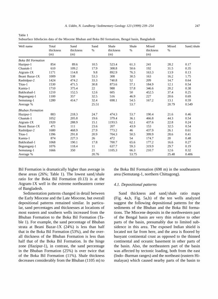
A. Uddin, N. Lundberg / Sedimentary Geology 123 (1999) 239–254 247
Table 1Subsurface lithofacies data of the Miocene Bhuban and Boka Bil formations, Bengal basin, Bangladesh
Well name Total Sand Sand Shale Shale Mixed Mixed Sand=shalethickness thickness % thickness % thickness %(m) (m) (m) (m)
Boka Bil FormationHazipur-1 854 89.6 10.5 523.4 61.3 241 28.2 0.17Chaatak-1 610 109.2 17.9 308.8 50.6 192 31.5 0.35Atgram-1X 1171 114.8 9.8 892.9 76.3 163.3 13.9 0.13Beani Bazar-1X 1009 538 53.3 308 30.5 163 16.2 1.75Rashidpur-2 1424 474.2 33.3 740.8 52 209 14.7 0.64Titas-1 1530 471.5 30.8 873.6 57.1 184.9 12.1 0.54Kamta-1 1710 375.4 22 988 57.8 346.6 20.2 0.38Bakhrabad-1 1210 152.5 12.6 605 50 452.5 37.4 0.25Begumganj-1 1100 357 32.5 516 46.9 227 20.6 0.69Semutang-1 1280 414.7 32.4 698.1 54.5 167.2 13.1 0.59Average % 25.51 53.7 20.79 0.549
Bhuban FormationHazipur-1 883 218.3 24.7 474.3 53.7 190.4 21.6 0.46Chaatak-1 1052 205.8 19.6 379.4 36.1 466.8 44.3 0.54Atgram-1X 1920 288.9 15.1 1193.5 62.1 437.6 22.8 0.24Beani Bazar-1X 471 111 23.6 207 43.9 153 32.5 0.54Rashidpur-2 1680 468.9 27.9 773.2 46 437.9 26.1 0.61Titas-1 1396 291.8 20.9 704.3 50.5 399.9 28.6 0.41Kamta-1 874 227.3 26 472 54 174.7 20 0.48Bakhrabad-1 1068 190.1 17.8 700.7 65.6 177.2 16.6 0.27Begumganj-1 1076 118.4 11 637.7 59.3 319.9 29.7 0.19Semutang-1 1666 350 21 1105.3 66.3 210.7 12.6 0.32Average % 20.76 53.75 25.48 0.406
Bil Formation is dramatically higher than average inthese areas (26%; Table 1). The lowest sand=shaleratio for the Boka Bil Formation (0.13) is at theAtgram-1X well in the extreme northeastern cornerof Bangladesh.
Sedimentation patterns changed in detail betweenthe Early Miocene and the Late Miocene, but overalldepositional patterns remained similar. In particu-lar, sand percentages and thicknesses at locations ofmost eastern and southern wells increased from theBhuban Formation to the Boka Bil Formation (Ta-ble 1). For example, the sand percentage of Bhubanstrata at Beani Bazar-1X (24%) is less than halfthat in the Boka Bil Formation (53%), and the over-all thickness of the Bhuban Formation is less thanhalf that of the Boka Bil Formation. In the hingezone (Hazipur-1), in contrast, the sand percentagein the Bhuban Formation (25%) is over twice thatof the Boka Bil Formation (11%). Shale thicknessdecreases considerably from the Bhuban (1105 m) to
the Boka Bil Formation (698 m) in the southeasternarea (Semutang-1, northern Chittagong).
4.1. Depositional patterns
Sand thickness and sand=shale ratio maps(Fig. 4a,b, Fig. 5a,b) of the ten wells analyzedsuggest the following depositional patterns for thesediments of the Bhuban and the Boka Bil forma-tions. The Miocene deposits in the northwestern partof the Bengal basin are very thin relative to otherparts of the basin, presumably due to limited sub-sidence in this area. The exposed Indian shield islocated not far from here, and the area is floored bybuoyant continental crust as opposed to the thinnedcontinental and oceanic basement in other parts ofthe basin. Also, the northeastern part of the basinwas affected by tectonic loading, both from the east(Indo–Burman ranges) and the northeast (eastern Hi-malayas) which caused nearby parts of the basin to

248 A. Uddin, N. Lundberg / Sedimentary Geology 123 (1999) 239–254
Fig. 4. Subsurface lithofacies maps of the Bengal basin showing trends in clastic sediment accumulation in the Lower to Middle MioceneBhuban Formation. (a) Isopach map of cumulative sand thickness (in meters). (b) Facies map of sand=shale ratio. (c) Trends of sanddeposition inferred for the Early to Middle Miocene.

A. Uddin, N. Lundberg / Sedimentary Geology 123 (1999) 239–254 249
Fig. 5. Subsurface lithofacies maps of the Bengal basin showing trends in clastic sediment accumulation in the Middle to Upper MioceneBoka Bil Formation. (a) Isopach map of cumulative sand thickness (in meters). (b) Facies map of sand=shale ratio. (c) Trends of sanddeposition inferred for Middle to Late Miocene; note overall similarity to trends inferred for the Early to Middle Miocene (see Fig. 4c).

250 A. Uddin, N. Lundberg / Sedimentary Geology 123 (1999) 239–254
subside further, helping to accommodate huge thick-nesses of Miocene sediments of the Surma Group.
Trends from the lithofacies maps of the MioceneSurma Group in Bangladesh suggest that deltaicdeposits filled the Sylhet trough of the northeastBengal basin from the east, and that the source ter-ranes of this sediment included the north-trendingIndo–Burman ranges directly adjacent to the eastand the eastern Himalayas. This is consistent withpreservation of thick orogenic sequences (Rao, 1983)in Assam, northeast India (Fig. 1). The consistent in-crease in sand percentages from the Bhuban to BokaBil formations in most of the eastern wells suggestsprogradation of the delta and=or westward migrationof the Indo–Burman ranges as a proximal source.
The lowest sand=shale ratio for the Boka BilFormation (0.13) is at the Atgram-1X well, in theextreme northeastern corner of Bangladesh. Thiswell is located remarkably close (about 30 km) tothe Beani Bazar-1X area, which has the highestsand=shale ratio (1.75). There is no obvious expla-nation for this anomaly; it may be due to structuralreasons, although no major fault has been recog-nized that might have juxtaposed the rocks of thesetwo areas. The area of the Atgram-1X well mayrepresent an interdistributary setting between majorchannels, one of which clearly drained through theBeani Bazar area.
Depocenters in the Bengal basin did not migratesignificantly during the Miocene, suggesting thatthere was no major shift in the location of maximumsubsidence during that time (Uddin, 1990). The im-mediate source of these sediments remained almostconstant, because the depocenters for the Early toMiddle Miocene Bhuban Formation and the Middleto Late Miocene Boka Bil Formation are only ¾30km apart. This insignificant shift of depocenters maybe attributed to channel shifting (avulsion) of a ma-jor Miocene river. Considering the Oligocene andMiocene stratigraphy of Assam, immediately to thenortheast, it is likely that this major river originatednear the eastern Himalayan syntaxis.
Increases in sand percentages from the Bhuban tothe Boka Bil formations in northeastern Bangladeshmay reflect westward advance of the Indo–Burmanorogenic front toward the Sylhet trough. The litho-facies maps also suggest the presence of another
river system, draining from the Indo–Burman rangesstraight to the Bengal fan through the northernChittagong Hills tracts (Figs. 4 and 5). These twoMiocene streams were likely distributaries of a ma-jor river system that transported orogenic sedimentinto the paleo-Bengal fan. The lithofacies maps alsosuggest that the Shillong Plateau, an uplifted massifof Precambrian basement rocks to the north of theBengal basin (Fig. 1), was not a source for SurmaGroup deposits. This finding is consistent with theresults of petrologic studies of sediments from theSylhet trough, which suggest that the plateau was up-lifted during Pliocene time (Johnson and Nur Alam,1991).
These Miocene lithofacies data from the easternand northern Bengal basin are consistent with petro-logic records in the Bengal basin sediments of ero-sional unroofing of the nearby orogenic belts. Clearevidence of this unroofing has been documented inMiocene through Pleistocene strata in the Bengalbasin, by both sandstone modal analysis (Uddin andLundberg, 1998a) and heavy-mineral data (Uddinand Lundberg, 1998b). The first clearly orogenic de-tritus appears in lowermost Miocene strata. Thesesands have substantial lithic components and bothplagioclase and potassium feldspars, as well as ahost of diverse heavy minerals, including aluminosil-icates, pyroxenes, amphiboles, and tourmalines, sug-gesting exhumation of metamorphic terranes fromthe adjacent orogenic belts to the east and north.
Relatively high sand content in the Bhuban For-mation in the Hazipur-1 area suggests that, like thefluvial network of the present-day Ganges, the north-western part of the Bengal basin was also drained bystream systems during the Early to Middle Miocene.There was shifting of one such channel in the LateMiocene, as seen by the lower sand percentage in theBoka Bil Formation. Input of detritus from the north-west has also been suggested by Salt et al. (1986),Alam (1989), and Lindsay et al. (1991). Seismicstratigraphy reveals that there were major sandy tidalmega-channels (8–10 km wide and 100 m deep) inthe southwestern part of the Bengal basin between10.5 and 5 Ma (Late Miocene; Lindsay et al., 1991).These data suggest that this area was an active partof the Ganges–Brahmaputra delta, in which a dis-tributary channel shifted through the Hazipur area.

A. Uddin, N. Lundberg / Sedimentary Geology 123 (1999) 239–254 251
4.2. Regional implications
Subsurface lithofacies maps show that Lowerto Middle Miocene sand-rich deltaic strata of theBhuban Formation define a large, elongate depocen-ter. The maximum grain size and sand thickness de-scribe a large-scale meander westward from Rashid-pur (northeast Bengal basin) and curving southwardtoward the Bay of Bengal and the Bengal fan.This sediment lobe can be traced down to south-ern Bangladesh. A second lobe distributed sedimentsouthward through the Chittagong Hills of southeast-ern Bangladesh, where sand contents and thicknessesare high relative to the surrounding regions. Therewas likely a third major stream in the northwesternBengal basin (in the Hazipur area, near the hinge
Fig. 6. Traces of drainage systems inferred from subsurface facies analysis. Paleo-Brahmaputra drainage is hypothesized to haveoriginated close to inferred location of eastern Himalayan syntaxis (on the basis of regional stratigraphic relationships) draining muchof the Assam valley to enter the northeastern Bengal basin. Deltaic deposition apparently prograded southwestward between advancingdeformation fronts of Himalaya and Indo–Burman orogens. Present-day locations of rivers, coastline, and Main Boundary Thrust shownfor reference.
zone), where long-term accumulation was restrictedby very limited subsidence.
Middle to Upper Miocene strata of the Boka BilFormation show a geographic trend similar to thatshown by the Bhuban Formation in deposition ofcoarsest and thickest sediment, but the depocenterhad shifted northward by about 30 km, passing nearBeani Bazar. As in the time of deposition of theBhuban Formation, there is also a second sedimentdistribution system that passed southward throughthe northwest Chittagong Hills tracts in southeasternBangladesh. Sand content in depocenters of the BokaBil Formation is generally higher than that in theBhuban Formation.
These data, taken together, suggest that there wasa major paleochannel, similar to the present-day

252 A. Uddin, N. Lundberg / Sedimentary Geology 123 (1999) 239–254
Brahmaputra, that flowed from near the eastern Hi-malayan syntaxis. This paleo-Brahmaputra systemapparently drained through the upper Assam valleyand reached the eastern part of the Sylhet trough toenter the Bengal basin, and eventually drained to theBengal fan (Fig. 6). These data also show that rocksof the Shillong Plateau were not a source of theMiocene deltaic sediments of the Bengal basin, con-sistent with inferred Pliocene uplift of the ShillongPlateau (Johnson and Nur Alam, 1991). The Indo–Burman ranges probably contributed sediment intothe Chittagong area, but the major sediment sourcefor Miocene strata of the Bengal basin was likely theearly uplifts of the eastern Himalayas.
The southeasternmost portion of the Bengal basincontains perhaps the only intact portion of the rem-nant Tethyan oceanic basement in the Himalayancollision (Curray et al., 1982; Klootwijk et al., 1992;Beck et al., 1995; and others). The collision prop-agated from west to east (Burchfiel, 1993; Rowley,1996), beginning during the Paleocene in Pakistan(Beck et al., 1995). Therefore, at the time significantuplifts began in the western Himalayas, the region tothe east was occupied by a shallow sea or only shal-low uplifts. Initial uplifts in the eastern Himalayasand the Indo–Burman ranges in the Oligocene, andmore intense uplift in the Miocene, apparently fun-nelled orogenic detritus along a major drainage (pa-leo-Brahmaputra?) through the remnant ocean basin.Miocene depocenters in the Bengal basin migratedfrom east to west and from north to south, toward theBay of Bengal, as underthrusting of India beneathsoutheast Asia along the present-day Java trench andits northern extension continued.
5. Conclusions
Analysis of subsurface well logs from the Ben-gal basin reveals the following deltaic sedimentationpatterns. Lower to Middle Miocene sand-rich de-posits of the Bhuban Formation accumulated in alarge-scale meander, extending westward from theeastern Sylhet trough and curving southward towardthe Bay of Bengal. A smaller distributary carriedsediment southward through the Chittagong Hillsregion. A third major stream in this area (paleo-Ganges?) apparently brought sediment into the Ben-
gal basin from the northwest, with little net sedimentpreservation. Geographic trends during the Middleto Late Miocene are very similar to those of theEarly to Middle Miocene, although sand contentgenerally increased through the Miocene. This inves-tigation suggests that a major paleo-drainage systemflowed from the eastern Himalayan syntaxis, drain-ing through present-day Assam and bringing oro-genic detritus into the Sylhet trough (Surma basin)from the east. The Indo–Burman ranges probablycontributed sediment into the Chittagong area, butthe major sediment source for Miocene strata ofthe Bengal basin was likely the early uplifts of theeastern Himalayas.
Acknowledgements
The authors thank the Honorable former Ministerfor Energy and Mineral Resources of the Govern-ment of Bangladesh and the former Chairman ofBOGMC for permission to analyze subsurface logsfrom BOGMC and BAPEX. BAPEX, and especiallyM. Moinul Huq and Nazim U. Ahmed, who providedvaluable logistical assistance. Andrew Miall, AllenClark, Leroy Odom, Jim Tull, and Paul Raglandhave provided constructive comments on an earlierversion of this paper. We thank NSF (grants INT-9300295 and EAR-9419086), Geological Society ofAmerica, Sigma Xi, and the Department of Geol-ogy at FSU for financial support. This paper wasimproved by thoughtful reviews by Peter DeCelles,George Postma, and Michael Zaleha.
References
Ahmed, A., 1983. Oligocene Stratigraphy and Sedimentationin the Surma Basin, Bangladesh. Unpublished M.Sc Thesis,University of Dhaka, Dhaka, 96 pp.
Ahmed, S.T., 1968. Cenozoic Fauna of the Cox’s Bazar CoastalCliff. Unpublished M.Sc Thesis, University of Dhaka, Dhaka,68 pp.
Alam, M., 1989. Geology and depositional history of Cenozoicsediments of the Bengal Basin of Bangladesh. Palaeogeogr.,Palaeoclimatol., Palaeoecol. 69, 125–139.
Alam, M.M., 1991. Paleoenvironmental study of the Barailsuccession exposed in northeastern Sylhet, Bangladesh.Bangladesh J. Sci. Res. 9, 25–32.
Bakhtine, M.I., 1966. Major tectonic features of Pakistan, Part II.

A. Uddin, N. Lundberg / Sedimentary Geology 123 (1999) 239–254 253
The Eastern Province. Sci. Ind. 4, 89–100.Baksi, S.K., 1962. Palynological investigation of Simsang river
Tertiaries, south Shillong Front, Assam. Bull. Geol., Mineral.Meteorol. Soc. India 26, 1–22.
Baksi, S.K., 1972. On the palynological biostratigraphy of theBengal basin. In: Ghosh, A.K., et al. (Eds.), Proceedings ofthe Seminar on Paleopalynology and Indian Stratigraphy. Dep.of Botany, Univ. of Calcutta, Calcutta, pp. 188–206.
Banerji, R.K., 1981. Cretaceous–Eocene sedimentation, tecton-ism and biofacies in the Bengal basin, India. Palaeogeogr.,Palaeoclimatol., Palaeoecol. 34, 57–85.
Banerji, R.K., 1984. Post-Eocene biofacies, palaeoenvironmentsand palaeogeography of the Bengal basin, India. Palaeogeogr.,Palaeoclimatol., Palaeoecol. 45, 49–73.
Beck, R.A., Burbank, D.W., Sercombe, W.J., Riley, G.W.,Barndt, J.K., Berry, J.R., Afzal, J., Khan, A.M., Jurgen, H.,Metje, J., Cheema, A., Shafique, N.A., Lawrence, R.D., Khan,M.A., 1995. Stratigraphic evidence for an early collision be-tween northwest India and Asia. Nature 373, 55–58.
Biswas, B., 1961. Geology of the Bengal Basin with Special Ref-erence to Stratigraphy and Micropaleontology. UnpublishedPh.D. Dissertation, Univ. of Calcutta, 138 pp.
Brunnschweiler, R.O., 1980. Lithostratigraphic monsters in mod-ern oil exploration. In: Proc. Offshore Southeast Asia Confer-ence, Singapore, pp. 1–7.
Burchfiel, B.C., 1993. Tectonic evolution of the Tibetan Plateauand adjacent regions. Geol. Soc. Am. Abstr. Progr. 25, A-39.
Chowdhury, S.Q., 1982. Palynostratigraphy of the Neogene sed-iments of the Sitapahar anticline (western flank), ChittagongHill Tracts. Bangladesh J. Geol. 1, 35–49.
Curray, J.R., 1994. Sediment volume and mass beneath the Bayof Bengal. Earth Planet. Sci. Lett. 125, 371–383.
Curray, J.R., Emmel, F.J., Moore, D.G., Raitt, R.W., 1982. Struc-ture, tectonics and geological history of the northeastern In-dian Ocean. In: Nairn, A.E.M., Stehli, F.G. (Eds.), The OceanBasins and Margins, Vol. 6. The Indian Ocean. Plenum, NewYork, pp. 399–450.
Evans, P., 1964. The tectonic framework of Assam. J. Geol. Soc.India 5, 80–96.
Graham, S.A., Dickinson, W.R., Ingersoll, R.V., 1975.Himalayan–Bengal model for flysch dispersal in theAppalachian–Ouachita system. Geol. Soc. Am. Bull. 86, 273–286.
Hiller, K., Elahi, M., 1984. Structural development and hydro-carbon entrapment in the Surma Basin, Bangladesh (northwestIndo–Burman Fold belt). In: Proc. 4th Offshore Southeast AsiaConference, Singapore, pp. 6-50–6-63.
Holtrop, J.F., Keizer, J., 1970. Some aspects of the stratigra-phy and correlation of the Surma basin wells, East Pakistan.ESCAFE Miner. Resour. Dev. Ser. 36, 143–154.
Johnson, S.Y., Nur Alam, A.M., 1991. Sedimentation and tec-tonics of the Sylhet trough, Bangladesh. Geol. Soc. Am. Bull.103, 1513–1527.
Khan, A.A., 1991. Tectonics of the Bengal basin. J. HimalayanGeol. 2, 91–101.
Khan, A.A., Agarwal, B.N.P., 1993. The crustal structure of
western Bangladesh from gravity data. Tectonophysics 219,341–353.
Khan, M.A.M., 1978. Geology of the eastern and the northeast-ern part of the Sadar Subdivision Sylhet District, Bangladesh.Geol. Surv. Bangladesh Rec. 2, 20 pp.
Khan, M.R., Muminullah, M., 1980. Stratigraphy of Bangladesh.In: Petroleum and Mineral Resources of Bangladesh, Semi-nar and Exhibition. Government of the People’s Republic ofBangladesh, Dhaka, pp. 35–40.
Khandoker, R.A., 1989. Development of major tectonic elementsof the Bengal basin: a plate tectonic appraisal. Bangladesh J.Sci. Res. 7, 221–232.
Klootwijk, C.T., Gee, J.S., Pierce, J.W., Smith, G.M., McFadden,P.L., 1992. An early India–Asia contact: paleomagnetic con-straints from Ninetyeast Ridge, ODP Leg 121. Geology 20,395–398.
Lietz, J.K., Kabir, J., 1982. Prospects and constraints of oilexploration in Bangladesh. In: Proceedings of 4th OffshoreSoutheast Asia Conference, Singapore, pp. 1–6.
Lindsay, J.F., Holliday, D.W., Hulbert, A.G., 1991. Sequencestratigraphy and the evolution of the Ganges–BrahmaputraDelta complex. Am. Assoc. Pet. Geol. Bull. 75, 1233–1254.
Naini, B.R., Leyden, R., 1973. Ganges cone: a wide angleseismic reflection and refraction study. J. Geophys. Res. 78,8711–8720.
Paul, D.D., Lian, H.M., 1975. Offshore Tertiary basins of south-east Asia: Bay of Bengal to South China Sea. 9th WorldPetroleum Congress, Vol. 3, pp. 107–121.
Radovich, B.J., Hoffman, M.W., Perlmutter, M.A., 1995. Up-side-down sequence stratigraphy, sandy highstands and muddyprograding complexes in the Surma basin, Bangladesh. Am.Assoc. Pet. Geol. Abstr. Progr. 4, 79A.
Rahman, Q.M.A., Sen Gupta, P.K., 1980. Geological log ofGDH-31. Geological Survey of Bangladesh, Dhaka (unpub-lished report).
Rao, A.R., 1983. Geology and hydrocarbon potential of a part ofAssam–Arakan basin and its adjacent region. Pet. Asia J. 6,127–158.
Reimann, K.-U., 1993. Geology of Bangladesh. Borntraeger,Berlin, 160 pp.
Rowley, D.B., 1996. Age of initiation of collision between Indiaand Asia: a review of stratigraphic data. Earth Planet. Sci.Lett. 145, 1–13.
Salt, C.A., Alam, M.M., Hossain, M.M., 1986. Bengal basin: cur-rent exploration of the hinge zone of southwestern Bangladesh.In: Proc. 6th Offshore Southeast Asia Conference, Singapore,pp. 55–67.
Sengupta, S., 1966. Geological and geophysical studies in west-ern part of Bengal basin, India. Bull. Am. Assoc. Pet. Geol.50, 1001–1017.
Uddin, A., 1990. Shift in depositional patterns during Miocenetime in the Bengal basin, Bangladesh. Geol. Soc. Am., Abstr.Progr. 22, 366.
Uddin, M.N., Ahmed, Z., 1989. Palynology of the Kopili Forma-tion at GDH-31, Gaibandha District, Bangladesh. BangladeshJ. Geol. 8, 31–42.
Uddin, A., Lundberg, N., 1998a. Cenozoic history of the

254 A. Uddin, N. Lundberg / Sedimentary Geology 123 (1999) 239–254
Himalayan–Bengal system: sand composition in the Bengalbasin, Bangladesh. Geol. Soc. Am. Bull. 110, 497–511.
Uddin, A., Lundberg, N., 1998b. Unroofing history of the easternHimalaya and the Indo–Burman ranges: heavy mineral studyof the Cenozoic sediments from the Bengal basin, Bangladesh.J. Sediment. Res. 68, 465–472.
Zaher, M.A., 1970. Limestone deposits of the western part of
the Takerghat area, district Sylhet, Pakistan. Rec. Geol. Surv.Pakistan 20 (2), 57–75.
Zaher, M.A., Rahman, A., 1980. Prospects and investigations forminerals in the northern part of Bangladesh. In: Petroleum andMineral Resources of Bangladesh, Seminar and Exhibition.Government of the People’s Republic of Bangladesh, Dhaka,pp. 9–18.