Embed Size (px)
Citation preview

AQUINCUMAQUINCUMA BTM Aquincumi Múzeumának ásatásai
és leletmentései 2003-banExcavations and rescue work at the
Aquincum Museum in 2003
Aqu
incu
mi f
üzet
ek 1
0

AQUINCUM
A BTM Aquincumi Múzeumának ásatásaiés leletmentései 2003-ban
Excavations and rescue workat the Aquincum Museum in 2003
Budapest, 2004

Szerkesztő:Zsidi Paula
Fordítás:Simán Katalin, Alice M. Choyke
Rajz:Málik Éva, Hable Tibor, Csernus Erzsébet, Kovács Tibor
Fotó:Komjáthy Péter, Gálné Tóth Csilla, T. Láng Orsolya, Ujvári Gábor
Geodézia:Busi György, Kovács Tibor
Technikai szerkesztő:Kolozsvári Krisztián
A külső borítón elöl: A Bécsi úti római kocsi lőcs vége
A külső borítón hátul: Lószerszám veret millefi ori díszítéssel a Bécsi úti kocsitemetkezésből
A belső borítón:A 2003-ban végzett megelőző feltárások helyszínei
Budapesti Történeti Múzeum, 2004Felelős kiadó: Dr. Bodó Sándor főigazgató
Budapest Historical Museum, 2004Editor-in-chief: Dr. Sándor Bodó, Director
Edited by:Paula Zsidi
Translation by: Katalin Simán, Alice M. Choyke
Drawings by:Éva Málik, Tibor Hable, Erzsébet Csernus, Tibor Kovács
Photos by:Péter Komjáthy, Csilla Gálné Tóth, Orsolya T. Láng, Gábor Ujvári
Surveying work by:György Busi, Tibor Kovács
Technical assistance by:Krisztián Kolozsvári
Front cover: Decoration on the Roman wagon draught pole from Bécsi Road
Back cover: Harness fi tting with millefi ori decoration from the Bécsi Road wagon grave
Inside cover:Locations of larger investment led excavations in 2003

A BTM Aquincumi Múzeumának ásatásaiés leletmentései 2003-ban
Excavations and rescue work at the Aquincum Museum in 2003
Budapesti Történeti MúzeumAquincumi Múzeum
Aquincumi füzetek10. szám
ISSN 1219-9419 (Aquincumi füzetek)ISSN 1219-9427 (Aquincum)
Régészeti feltárások Budapest területén 2003-ban (Zsidi Paula) . . . . . . . . . . . . . . 8
A 2003-ban végzett nagyobb megelőző feltárások helyszínei . . . . . . . . . . . . . . . 13
Második századi sírok a katonaváros nyugati temetőjéből (Hable Tibor). . . . 15
Temetőfeltárás a Bécsi úton (R. Facsády Annamária) . . . . . . . . . . . . 21
Korai telepjelenségek kutatása az aquincumi canabae déli régiójában (Madarassy Orsolya) . . . . . . . . . . . . . . . 30
Régészeti kutatások a Hajógyári-öbölben (H. Kérdő Katalin – Tóth János Attila – Németh Margit – Kirchhof Anita) . . . 37
Topográfi ai kutatás az aquincumi legiótábor északkeleti előterében (Németh Margit). . . . . . . . . . . . . . . . . . 42
Kora római védmű és késő avar kori telep kutatása a canabae északi előterében (Budai Balogh Tibor) . . . . . . . . . . . . . . 47
Római kori beépítettség kutatása az aquincumi polgárváros déli városfalán kívül (T. Láng Orsolya) . . . . . . . . . . . . . 57
Feltárás a Szentendrei úti aquaeductus nyomvonalán (Havas Zoltán) . . . . . . . . 61
Archaeological excavations in 2003 in the territory of Budapest (Paula Zsidi). . . . . 8
Locations of larger investment led excavations in 2003. . . . . . . . . . . . . . . . 13
Second century graves from the western cemetery of the Military Town (Tibor Hable) . . . . . . . . . . . . . . . . . . . . 15
Excavation at a cemetery in Bécsi Road (Annamária R. Facsády) . . . . . . . . . . . . 21
The investigation of the early periods in the southern section of the Aquincum canabae (Orsolya Madarassy) . . . . . . . . 30
Archaeological investigations in the Hajógyári-cove (Katalin H. Kérdő – János Attila Tóth – Margit Németh – Anita Kirchhof) . . . 37
Topographic investigations in the northeast foreground of the legionary fortress of Aquincum (Margit Németh) . . . . . . . . . 42
Investigations of early Roman defence works and a Late Avar settlement in the northern outskirts of the canabae (Tibor Budai Balogh) . . . . . . . . . . . . . . 47
Investigation of Roman period occupation outside the southern town wall of the Aquincum Civil Town (Orsolya T. Láng) . . . . . . . . . . . . . . . . . 57
Tartalom Contents
A Szentendrei út – Záhony utca kereszteződésénél lévő római kori vízvezeték „pillér csonkok” technikai és műemlékvédelmi mentése (Vladár Ágnes) . . . . . . . . . . . . . . . . . . . 66
Feltárások az aquincumi polgárváros délkeleti előterében (Lassányi Gábor – Zsidi Paula) . . . . . . 72
Római kori temetőrészlet az aquincumi polgárváros északkeleti szomszédságában (T. Láng Orsolya) . . . . . . . . . . . . . . . . . 82
Újabb adatok az úgynevezett Testvérhegyi villa topográfi ai helyzetéhez (T. Láng Orsolya) . . . . . . . . . . . . . . . . . 90
Feltárások a vízivárosi castellumtól északra (H. Kérdő Katalin – Végh András) . . . 106
Újabb római kori sírok a vízivárosi ala-tábor déli temetőjéből (Benda Judit – Hable Tibor – Horváth M. Attila) . . 110
Feltárások és leletmentések az auxiliaris castellum vicusában Albertfalván (Szirmai Krisztina – Beszédes József) . . 116
Másodlagosan felhasznált római kori sírkő a Herman Ottó utcából (Beszédes József) . . . . . . . . . . . . . . . . . 123
Nagytétény-CAMPONA 2003 (Kocsis László) . . . . . . . . . . . . . . . . . . 126
Középső bronzkori település nyomai Lágymányoson (Beszédes József – Szilas Gábor). . . . . 147
Feltárás a Paskál lakópark területén (Endrődi Anna – Horváth M. Attila) . . 153
Excavation along the aqueduct on Szentendrei Road (Zoltán Havas) . . . . 61
Technical and monument rescue of the “pillar butts” of the Roman aqueduct at the intersection of Szentendrei Road and Záhony Street (Ágnes Vladár) . . . . . . . . . . . . . . . . . . . 66
Excavations in the southeastern foreground of the Aquincum Civil Town (Gábor Lassányi – Paula Zsidi) . . . . . . 72
Part of a Roman period cemetery northeast of the Aquincum Civil Town (Orsolya T. Láng) . . . . . . . . . . . . . . . . . 82
New data on the topographic position of the so-called Testvérhegy villa (Orsolya T. Láng) . . . . . . . . . . . . . . . . . 90
Excavations north of the Víziváros castellum (Katalin H. Kérdő – András Végh) . . . 106
New Roman period graves from the southern cemetery of the Víziváros auxilary fort (Judit Benda – Tibor Hable – Attila Horváth M.) . . . . . . . . . . . . . . 110
Excavations and rescue work in the vicus of the auxiliary castellum at Albertfalva (Krisztina Szirmai – József Beszédes) . . . . . . . . . . . . . . . . 116
Secondary use of a Roman period tombstone from Herman Ottó Street (József Beszédes) . . . . . . . . . . . . . . . . . 123
Nagytétény-CAMPONA 2003 (László Kocsis) . . . . . . . . . . . . . . . . . . 126

Középső neolitikus település Törökbálint-Dulácskán (Horváth László András). . . . . . . . . . . 156
Őskori telepek, római kori árokrendszer, avar sírok Biatorbágy-Hosszúrétek lelőhelyen (Reményi László – Tóth Anikó) . . . . . 160
Őskori és középkori leletek Biatorbágy-Tyúkberek, Törökbálint-Kukoricadűlő lelőhelyről (Reményi László – Terei György) . . . . 168
Szigetszentmiklós-Laki hegy-Dunára-dűlő (Reményi László – Terei György) . . . . 172
Az Aquincumi Múzeum kisebb feltárásainak helyszínei és eredményei a 2003. évben . . . . . . . . . . . . . . . . . . . 177
Az Aquincumi Múzeum régészeti célú megfi gyelései 2003-ban . . . . . . . . . . . 193
Rövidítésjegyzék . . . . . . . . . . . . . . . . . 195
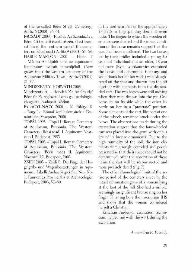
A 2003. évi feltárások közreműködői . . . . . . . . . . . . . . . . . . . 196
A 2003. évi feltárások megbízói és támogatói . . . . . . . . . . . . . . . . . . . . . . 199
Az Aquincumi Múzeum munkatársainak 2003-ban megjelent publikációi . . . . 202
Traces of a Middle Bronze Age settlement at Lágymányos (József Beszédes – Gábor Szilas). . . . . 147
Excavation in the territory of the Paskál apartment complex (Anna Endrődi – Attila Horváth M.) . . 153
A Middle Neolithic settlement at Törökbálint-Dulácska (András László Horváth). . . . . . . . . . . 156
Prehistoric settlements, a ditch system from the Roman period, Avar graves at the site of Biatorbágy-Hosszúrétek (László Reményi – Anikó Tóth) . . . . . 160
Prehistoric and medieval fi nds from Biatorbágy-Tyúkberek, Törökbálint-Ku ko ri ca dűlő site (László Reményi – György Terei) . . . . 168
Szigetszentmiklós-Laki hegy-Dunára-dűlő (László Reményi – György Terei) . . . . 172
Locations of and results from small-scale excavations conducted by the Aquincum Museum in 2003. . . . . . . . . . . . . . . . . 191
Archaeological observation work carried out by the Aquincum Museum in 2003 . . . . . . . . . . . . . . . . . . . . . . . . 193
Abbreviations . . . . . . . . . . . . . . . . . . . 195
Participants in the excavations in 2003 . . . . . . . . . . . . . . . . . . . . . . . . 196
Employers and patrons of the Excavations in 2003 . . . . . . . . . . . . . . 199
Publications by the staff of the Aquincum Museum in 2003 . . . . . . . 202
A BTM régészeti osztályainak változat-lanul a főváros régészeti örökségének védelmével kapcsolatos feltárások adták a legtöbb feladatot a 2003. évben is. Az in-tézmény 22 régésze 81 fővárosi helyszínen végzett ásatást (86 megkötött szerződés alapján), melyek mindegyike a fővárosban folyó beruházásokhoz, építkezésekhez kapcsolódott. Az ásató régészek összesen 2185 napot töltöttek terepen, kutatónként 3-4 helyszínen végezték munkájukat. En-nek alapján elmondható, hogy az ország-ban végzett összes feltárás egyötöde–egy-hatoda 2003-ban is Budapest területén zajlott. A régészeti örökségvédelmi munka jelen tősége az új építési technológiák és előírások (mélygarázs) időszakában egyre nő, hiszen az új beruházásokkal többnyire nemcsak elfedik, hanem el is pusztítják a lelőhelyet. Egyetlen év alatt a főváros tör-ténetéről tanúskodó, több mint 100.000 négyzetméternyi terület semmisült meg az építkezések során, s csaknem ugyan-ekkora terület vált véglegesen, vagy hosz-szú időre kutathatatlanná, szerencsére a jelen leg érvényben lévő törvény, a hatóság és a múzeum jóvoltából, nem dokumen-tálatlanul. A régészeti örökségvédelmi munkát a 2001. októberében életbe lépett, a kul-turális örökségvédelemről szóló törvény alapján végezzük, szoros együttműködés-
Régészeti feltárások Budapest területén 2003-ban
8
Archaeological excavations in 2003 in the territory of Budapest
The major task of the archaeological departments of the Budapest Historical Museum was linked to the protection of archaeological heritage in the Capital in 2003 as well. Twenty-two archaeologists conducted excavations at 81 sites in the Capital (based on 86 signed contracts). All were connected with development and construction work in Budapest. The archaeologists spent altogether 2185 days in the fi eld, and each of these specialists worked at 3-4 sites. Thus, it can be said that one fi fth or sixth of the excavations in the country as a whole were conducted in the territory of Budapest in 2003 as well. The signifi cance of archaeological protec-tion of the heritage has been increased by the appearance of new construction tech-nologies and regulations (deep parking), since the new investments do not simply cover the sites but mostly destroy them. In a single year, more than 100.000 square meters containing data related to the his-tory of the Capital were destroyed, and the territory that has been removed from investigation either ultimately or for a long time is almost as large; luckily this has not occurred without being documentation owing to established law, the effectiveness of the authorities and the museum. The protection of the archaeological cultural heritage is based on the Act deal-
ben a Kulturális Örökségvédelmi Hivatal-lal, amely intézmény a korábban a múze-um által végzett szakhatósági feladatokat is ellát. Ezzel együtt régész munkatársaink munkaidejének jelentős részét tölti ki az ásatások előkészítése, az ezzel kapcsolatos felvilágosítások, szervezés, adminisztráció, s a beruházókkal folytatott tárgyalások. Az ásatás jó előkészítése a gyors, gördülékeny feltárásnak egyik legfontosabb feltétele. Ezt azonban sokszor lehetetlenné teszi, hogy maguk a beruházások többségükben rosszul vagy nem kellően előkészítettek, s ez alól a nagy országos beruházások sem kivételek. Előfordul, hogy érvényes szerződés és ásatási engedély birtokában sem tudjuk megkezdeni a munkát, mert a terület kisajátítása még nem történt meg. Sokszor a beruházó – bár a múzeumtól elvárja a feltárás pontos időtartamának és pénzügyi kereteinek meghatározását – még maga sincs tisztában, hogy a be-ruházás mekkora földmunkával jár, azaz milyen mértékben veszélyezteti az épít-kezés a régészeti örökséget. Gyakori, hogy a tervezők menet közben, az építkezés során változtatnak a terveken, ami újabb területek feltárását igényelné. Ezekben az esetekben azonban a beruházók nem indítanak új hatósági eljárást, az emlékek pusztulását a régész „veszi észre”. Ekkor azonban a kialakult helyzetet már nehéz kezelni anélkül, hogy az az építkezés gördülékeny menetét ne befolyásolja. Új elem ként jelent meg az elmúlt időszak-ban, hogy szakmai érvek helyett hatalmi szóval és befolyással igyekeztek a beruhá-zók a feltárások menetét, az örökségvédő munkát befolyásolni. A 2003-ban, a kulturális örökségvédel-mi hatástanulmányról megjelent rendelet további feladatot rótt a múzeum régészei-re. Az örökségvédelmi hatástanulmány
ing with the protection of the cultural heritage, which came into force in Octo-ber 2001, in close co-operation with the Offi ce of Cultural Heritage Protection. This offi ce carries out the archaeologi-cal authoritative duties formerly carried out by the museum. Nevertheless, the preparations for the excavations, obtaining the necessary information, organization, administration and negotiations with the investors take long hours out of the work-ing time of the museum archaeologists. Proper preparation is one of the most important prerequisites of fast, smooth running of excavations. This, however, is often hindered by the fact that the major-ity of the investors themselves are poorly or not suffi ciently prepared, including the large, national investors. It has happened that we were not able to begin investiga-tions, even where a signed contract and a license for excavation had been fi nalized, since the territory had not yet been taken over. Often the investor, who expects that the museum respects their work deadlines and fi nancial frameworks of the excava-tion, is not aware of the extent of the earth moving required by the particular development, that is, the extent to which the construction will endanger the ar-chaeological heritage it impacts with. The architects frequently modify their designs during operations and construc-tion, requiring excavation of altogether new territories. In these cases, however, the investors do not initiate new proceed-ings but it is left to the archaeologists to “detect” the destruction of monuments. At this point, it is already diffi cult to manage the established situation without negatively affecting the smooth course of the construction. It was a new element in 2003 that the investors tried to infl uence
9
régészeti tanulmányrészének kidolgozása ugyanis a régészetileg érintett területek mindegyikén szükséges az önkormány-zatok rendezési és szabályozási terveinek elkészítéséhez, minimum az adatszolgál-tatás szintjén. Ez az új feladat elsősorban Régészeti Adattárunk munkáját szapo-rította. Ehhez az új rendelethez kapcso-lódóan a múzeum mintegy 15 régé szét jegyezték be a NKÖM szakértői névjegy-zékébe. A múzeum munkatársai a törvényi előírásokban foglalt dokumentációs, lelet-konzerválási, nyilvántartási feladatoknak is igyekeznek eleget tenni. Az ásatási doku-mentációk készítése a digitális adatrögzí-tés térhódításával gyorsabbá vált, azonban a hazai restaurálás szűk kapacitása miatt az idei évben előkerült 1021 ládányi lelet-anyag konzerválása, s ennek következté-ben elsődleges nyilvántartása késedelmet szenved. Az állandósult kampány, a feltárások szervezésével és bonyolításával járó nehéz-ségek valamint az új, többlet-feladatok ellenére a BTM régészei ebben az évben is sikerrel oldották meg a feltárási és örökség-védelmi munkát. Az ásatások során a fővá-ros számos, már korábban ismert lelőhelyé-ről nyertünk újabb, kiegészítő információt, de a 2003. évi kutatások néhány országos visszhangot is kiváltó régészeti szenzáció-val szolgáltak. Közöttük is első helyen áll, a már korábban ismert, Aquincum nyugati temetőjének (úgynevezett Bécsi úti római kori temető) egyik parcellájában lovakkal együtt eltemetett, kocsi maradványainak előkerülése. A kocsi számos, bronzból és vasból készült szerkezeti elemét és több fi gurális bronz díszítőelemét is magában foglaló lelet jelentőségét nemcsak az adja meg, hogy ez az első Aquincumban feltárt római kori közlekedési eszköz, hanem a
10
the course of the excavations and protec-tion of the cultural heritage using a policy of power-play and peremptory decisions instead of professional argument. The published order concerning the effectiveness of cultural heritage pro-tection in 2003, allotted the museum archaeologists even more tasks. Namely, the archaeological part of the study of the effectiveness of the heritage protec-tion must be prepared separately for every archaeologically relevant territory, at least on the level of data service, so that local governments can work out development and regulation plans. In particular, this task further burdened the work of the Archaeological Archives. In connection with this new decree, about 15 archaeolo-gists from the museum were registered in the Ministry of National Cultural Heritage Protection’s (NKÖM) list of experts. The museum archaeologists have made every effort to fulfi ll the documentation, fi nd conservation and recording require-ments spelled-out in the Act. The exca-vation documentation can be prepared faster since digital data recording has been accepted, while the conservation of the fi nd material unearthed this year, which fi lls 1021 cases, is obstructed by the low restoration capacity in Hungary, con-sequently causing delays in its primary cataloguing. Despite the permanent nature of the campaign, the diffi culties raised by the organisation and management of ex-cavations and the new, extra tasks, the archaeologists of the Budapest Historical Museum successfully carried out the ex-cavations and heritage protection this year as well. We obtained new, complementary information on numerous already known sites in the Capital. The investigations

lelet lelőkörülményei is. Ez a római kori helybenélő kelta-eraviszkusz lakosságra jellemző temetkezési rítus ugyanis ed-dig nem került elő a provinciaszékhely, Aquincum területéről, ahol egyébként az eraviszkuszok törzsi központja volt. Újabb értékes adattal gazdagodott továbbá az aquincumi helytartói palota együtte-se is. Részben a KÖH búvárrégészeti közreműködésével, valamint kiegészítő dendrokronológiai vizsgálatokkal sikerült felmérni és dokumentálni a palotához tartozó egykori római kori kikötő kő- és facölöpökből álló szerkezetét. Ez az újabb értékes és egyedülálló részlet gazdagította a helytartói palota majdani bemutatásá-nak lehetőségeit, s jelentősen emelte a palotaegyüttes nemzetközi szinten is kie-melkedő, régészeti-műemléki értékét. Az aquincumi polgárvárosi kutatások is szót érdemelnek a szenzációk között. A pol-gárváros körzetében több helyszínen folyt feltárások nemcsak új temetőrészlettel, a déli városfal előtti előváros kutatásával, hanem a vízvezeték egy szakaszának hite-lesítő feltárásával is gazdagították korábbi ismereteinket. Ennek nyomán a vízveze-ték pusztulási folyamatának korábban is-meretlen részletei kaptak új megvilágítást. Rendkívül gazdag leletanyag származott a polgárváros déli előterében feltárt római kori városi „szemétlerakóhely” feltárásá-ból. A szokatlanul gazdag import (terra si-gillata, amphora) és házikerámia anyagot, falfestményt, valamint állatcsontot tartal-mazó réteg feldolgozása várhatóan új ada-tokkal fog szolgálni a város gazdaságára, kereskedelmi kapcsolataira vonatkozólag. A feltárások mellett a BTM régészei folyamatosan végezték tudományos, pub-likációs munkájukat. 2003-ban csaknem 100 különböző cikkben, tanulmányban, s önálló kötetben tették közzé tudomá-
conducted in 2003 resulted in a few sen-sational archaeological fi nds, creating a stir throughout the country. The fi rst of these was the recovery of the remains of a dismantled wagon buried together with a pair of horses in a parcel from the well-known western cemetery of Aquincum (also known as the Roman cemetery on Bécsi Road). The signifi cance of the fi nd, comprising numerous bronze and iron structural elements and a number of fi gural ornaments from the elaborate wagon is underlined not only by the fact that this is the fi rst such Roman vehicle unearthed in Aquincum but also by the fi nd circumstances. This burial rite, char-acteristic of the autochthonous Celtic-Eraviscan population surviving in the Ro-man period, has not yet been found in the territory of Aquincum, the administrative center of the province, which was, at the same time, the tribal center of the Eravis-cans. Furthermore, new interesting data have been obtained from the proconsul’s palace complex in Aquincum. With the co-operation of underwater archaeologists and complementary dendrochronological analyses, we were able to survey and docu-ment the stone and timber post structure harbor of the palace from the Roman period. These new and unique details enriched the possibilities for future recon-struction of the proconsul’s palace and signifi cantly raised the archaeological and monumental value of the palace complex, which is prominent internationally as well. The investigations in the Civil Town of Aquincum also deserve to be mentioned among these sensational results. The excavations, conducted at a number of locations in the environs of the Civil Town, enriched our knowledge through the discovery of new parts of a cemetery,
11

nyos eredményeiket. Kiemelést érdemel az Aquincumi Múzeum tudományos gárdájának nagyszabású vállalkozása, az elmúlt harminc év aquincumi kutatási eredményeit összefoglaló „Forschungen in Aquincum (1969–2002)”, az Aquincum Nostrum II.2. köteteként, melyet sajtótá-jékoztatón mutattunk be.
Zsidi Paula
12
the investigation of the foreground of the southern town wall and also by the au-thenticating excavation of a stretch of the aqueduct. In consequence, new details of the destruction process affecting the aqueduct have been revealed. An excep-tionally rich fi nd material was recovered from the excavation of the “refuse dump” of the Roman Civil Town unearthed in its southern outskirts. The analysis of this archaeological layer, containing an extremely rich imported (Samian ware and amphora) and household ceramic material, wall paintings and animal bones, will most probably yield new data on the economy and commercial contacts in the town. Beside excavations, the archaeologists of the Budapest Historical Museum pub-lished in 2003, describing their scientifi c achievements in nearly 100 articles, stud-ies and volumes. The large-scale enter-prise of the scientifi c staff at the Aquin-cum Museum deserves separate mention. The volume, “Forschungen in Aquincum (1969–2002)”, a recapitulation of the investigations in Aquincum over the past thirty years, was edited as volume II.2 of Aquincum Nostrum. It was formally intro-duced to the interested public at a press conference.
Paula Zsidi
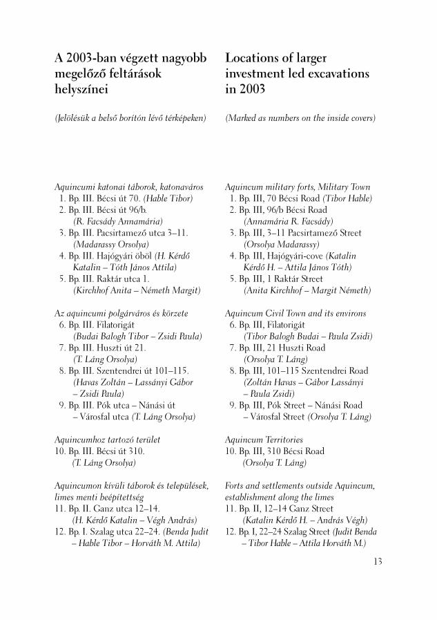
Aquincumi katonai táborok, katonaváros 1. Bp. III. Bécsi út 70. (Hable Tibor) 2. Bp. III. Bécsi út 96/b.
(R. Facsády Annamária) 3. Bp. III. Pacsirtamező utca 3–11.
(Madarassy Orsolya) 4. Bp. III. Hajógyári öböl (H. Kérdő
Katalin – Tóth János Attila) 5. Bp. III. Raktár utca 1.
(Kirchhof Anita – Németh Margit)
Az aquincumi polgárváros és körzete 6. Bp. III. Filatorigát
(Budai Balogh Tibor – Zsidi Paula) 7. Bp. III. Huszti út 21.
(T. Láng Orsolya) 8. Bp. III. Szentendrei út 101–115.
(Havas Zoltán – Lassányi Gábor – Zsidi Paula)
9. Bp. III. Pók utca – Nánási út – Városfal utca (T. Láng Orsolya)
Aquincumhoz tartozó terület 10. Bp. III. Bécsi út 310.
(T. Láng Orso lya)
Aquincumon kívüli táborok és települések, limes menti beépítettség 11. Bp. II. Ganz utca 12–14.
(H. Kérdő Katalin – Végh András) 12. Bp. I. Szalag utca 22–24. (Benda Judit
– Hable Tibor – Horváth M. Attila)
A 2003-ban végzett nagyobb megelőző feltárások helyszínei
(Jelölésük a belső borítón lévő térképeken)
Locations of larger investment led excavations in 2003
(Marked as numbers on the inside covers)
Aquincum military forts, Military Town 1. Bp. III, 70 Bécsi Road (Tibor Hable) 2. Bp. III, 96/b Bécsi Road
(Annamária R. Facsády) 3. Bp. III, 3–11 Pacsirtamező Street
(Orsolya Madarassy) 4. Bp. III, Hajógyári-cove (Katalin
Kérdő H. – Attila János Tóth) 5. Bp. III, 1 Raktár Street
(Anita Kirchhof – Margit Németh)
Aquincum Civil Town and its environs 6. Bp. III, Filatorigát
(Tibor Balogh Budai – Paula Zsidi) 7. Bp. III, 21 Huszti Road
(Orsolya T. Láng) 8. Bp. III, 101–115 Szentendrei Road
(Zoltán Havas – Gábor Lassányi – Paula Zsidi)
9. Bp. III, Pók Street – Nánási Road – Városfal Street (Orsolya T. Láng)
Aquincum Territories 10. Bp. III, 310 Bécsi Road
(Orsolya T. Láng)
Forts and settlements outside Aquincum, establishment along the limes 11. Bp. II, 12–14 Ganz Street
(Katalin Kérdő H. – András Végh) 12. Bp. I, 22–24 Szalag Street (Judit Benda
– Tibor Hable – Attila Horváth M.)
13
14
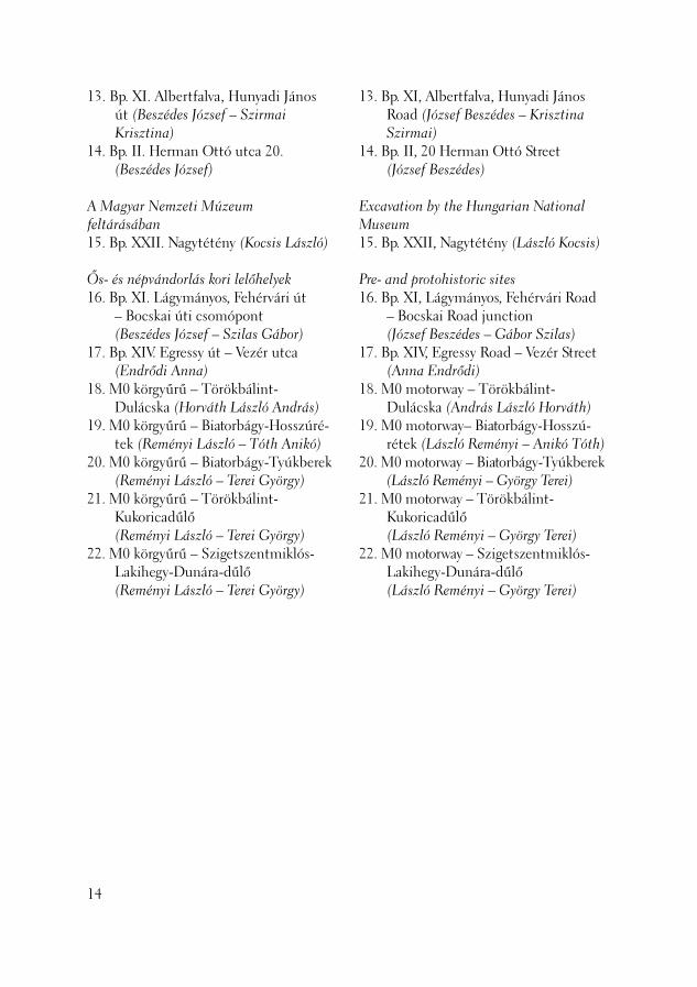
13. Bp. XI. Albertfalva, Hunyadi János út (Beszédes József – Szirmai Krisztina)
14. Bp. II. Herman Ottó utca 20. (Beszédes József)
A Magyar Nemzeti Múzeum feltárásában 15. Bp. XXII. Nagytétény (Kocsis László)
Ős- és népvándorlás kori lelőhelyek 16. Bp. XI. Lágymányos, Fehérvári út
– Bocskai úti csomópont (Beszédes József – Szilas Gábor)
17. Bp. XIV. Egressy út – Vezér utca (Endrődi Anna)
18. M0 körgyűrű – Törökbálint-Dulácska (Horváth László András)
19. M0 körgyűrű – Biatorbágy-Hosszúré-tek (Reményi László – Tóth Anikó)
20. M0 körgyűrű – Biatorbágy-Tyúkberek (Reményi László – Terei György)
21. M0 körgyűrű – Törökbálint-Kukoricadűlő (Reményi László – Terei György)
22. M0 körgyűrű – Szigetszentmiklós-Lakihegy-Dunára-dűlő (Reményi László – Terei György)
13. Bp. XI, Albertfalva, Hunyadi János Road (József Beszédes – Krisztina Szirmai)
14. Bp. II, 20 Herman Ottó Street (József Beszédes)
Excavation by the Hungarian National Museum 15. Bp. XXII, Nagytétény (László Kocsis)
Pre- and protohistoric sites 16. Bp. XI, Lágymányos, Fehérvári Road
– Bocskai Road junction (József Beszédes – Gábor Szilas)
17. Bp. XIV, Egressy Road – Vezér Street (Anna Endrődi)
18. M0 motorway – Törökbálint-Dulácska (András László Horváth)
19. M0 motorway– Biatorbágy-Hosszú-rétek (László Reményi – Anikó Tóth)
20. M0 motorway – Biatorbágy-Tyúkberek (László Reményi – György Terei)
21. M0 motorway – Törökbálint-Kukoricadűlő (László Reményi – György Terei)
22. M0 motorway – Szigetszentmiklós-Lakihegy-Dunára-dűlő (László Reményi – György Terei)

2003 július 2. és augusztus 29. között újabb csontvázas és szórthamvas sírokat tártunk fel az aquincumi canabae nyugati temetőjében (1. kép: 1), 100 méterre délre az ismert legkorábbi, Kr. u. 1.-2. századi parcelláktól. (BÓNIS 1947, 1. kép: 2) A K & M Kft., OBELISZK-SB Kft. és PANNON-IB Kft. tu laj donában lévő ingatlan összterületének több mint felét (410 négyzetmétert) átkutattuk. Igazodva a beépítési tervekhez, nem ástunk a telek nyugati negyedében, 2,5 méter széles biztonsági sávban, a Bécsi út 68. számú épület tűzfala mellett, illetve egy mély újkori pince miatt nem nyitottuk meg a 18., 26, 27. és 28. szektort. Kertműveléssel és újkori alpozásokkal sok helyütt mélyen átforgatták a talajrétegeket. (1. kép: 3) Nem találtunk római kori objektumokat a 11., 21., 16. és 17. szektorban. Egykor, a vékonyabb humusztakaró alól még kilátszó, ha talmas mészkősziklákba sem vágtak sírokat. (1. kép: 4) Másutt tágasabb volt a teraszos domboldal, itt kisebb, zsúfolt felületekre tagolódott a római temető is. (HABLE–MÁRTON 2001, 21–37) Negyven munkanap alatt 8 csontvázas és 22 hamvasztásos temetkezést doku-mentáltunk, de csak a szórványleletek, illetve a teljes leletanyag kiértékelése után lesz eldönthető, hogy a parcellát használ-ták-e a Severus-dinasztia uralkodásának
Második századi sírok a katonaváros nyugati temetőjéből
(Budapest, III. ker., Bécsi út 70., Hrsz.: 14737/3)
Second century graves from the western cemetery of the Military Town
(Budapest III, 70. Bécsi Road, Ln: 14737/3)
Further inhumation and cremation graves with scattered ashes were unearthed in the western cemetery of the Aquincum canabae between July 2 and August 29, 2003 (Fig. 1: 1), 100 m south of the earliest lots from the AD 1st-2nd centuries (BÓNIS 1947, Fig. 1: 2). We investigated more than half (401 m2) of the entire territory of the lot owned by the K & M Kft., the OBE-LISZK-SB Kft. and the PANNON-IB Kft. In conformity with the construction plans, we did not excavate in the western quarter of the lot in the 2.5 m wide security zone along the fi rewall of the building at 68 Bécsi Road and we did not open sectors 18, 26, 27 and 28 because there was a deep mo-dern cellar extending over these areas. The stratigraphic levels were disturbed down to a great depth by horticulture and modern foundations (Fig. 1: 3). We did not fi nd features from the Roman period in sectors 11, 21, 16 and 17. No graves were cut into the huge limestone rocks cropping out from the once thinner humus layer (Fig. 1: 4). In other places, the hillside terraces were mo-re spacious, whereas the Roman cemetery was broken up into smaller, crowded surfa-ces (HABLE–MÁRTON 2001). We could document 8 inhumation and 22 cremation burials during 40 workdays. However, it was only possible to decide if the parcel was in use until the end of
15
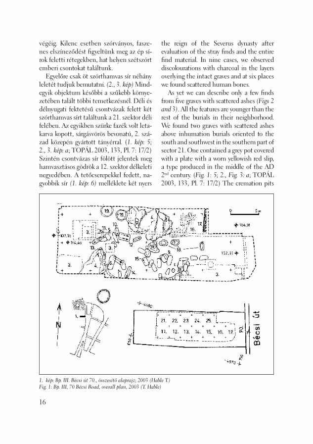
1
végéig. Kilenc esetben szórványos, fasze-nes elszíneződést fi gyeltünk meg az ép sí-rok feletti rétegekben, hat helyen szétszórt emberi csontokat találtunk. Egyelőre csak öt szórthamvas sír néhány leletét tudjuk bemutatni. (2., 3. kép) Mind-egyik objektum későbbi a szűkebb környe-zetében talált többi temetkezésnél. Déli és délnyugati fektetésű csontvázak felett két szórthamvas sírt találtunk a 21. szektor déli felében. Az egyikben szürke fazék volt leta-karva kopott, sárgásvörös bevonatú, 2. szá-zad közepén gyártott tányérral. (1. kép: 5; 2., 3. kép: a; TOPÁL 2003, 133, Pl. 7: 17/2) Szintén csontvázas sír fölött jelentek meg hamvasztásos gödrök a 12. szektor délkeleti negyedében. A tetőcserepekkel fedett, na-gyobbik sír (1. kép: 6) melléklete két nyers
1F
. kép: Bp. III. Bécsi út 70., összesítő alaprajz; 2003 (Hable T.)ig. 1: Bp. III, 70 Bécsi Road, overall plan, 2003 (T. Hable)6
the reign of the Severus dynasty after evaluation of the stray fi nds and the entire fi nd material. In nine cases, we observed discolourations with charcoal in the layers overlying the intact graves and at six places we found scattered human bones. As yet we can describe only a few fi nds from fi ve graves with scattered ashes (Figs 2 and 3). All the features are younger than the rest of the burials in their neighborhood. We found two graves with scattered ashes above inhumation burials oriented to the south and southwest in the southern part of sector 21. One contained a grey pot covered with a plate with a worn yellowish red slip, a type produced in the middle of the AD 2nd century. (Fig. 1: 5; 2., Fig. 3: a; TOPÁL 2003, 133, Pl. 7: 17/2) The cremation pits
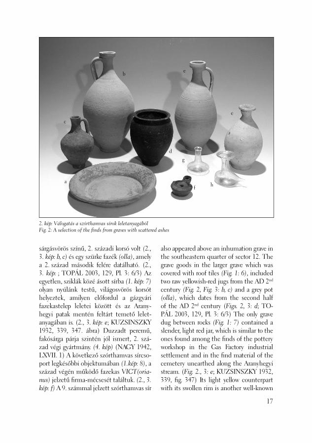
sárgásvörös színű, 2. századi korsó volt (2., 3. kép: b, c) és egy szürke fazék (olla), amely a 2. század második felére datálható. (2., 3. kép: ; TOPÁL 2003, 129, Pl. 3: 6/3) Az egyetlen, sziklák közé ásott sírba (1. kép: 7) olyan nyúlánk testű, világosvörös korsót helyeztek, amilyen előfordul a gázgyári fazekastelep leletei között és az Arany-hegyi patak mentén feltárt temető lelet-anyagában is. (2., 3. kép: e; KUZSINSZKY 1932, 339, 347. ábra) Duzzadt peremű, fakósárga párja szintén jól ismert, 2. szá-zad végi gyártmány. (4. kép) (NAGY 1942, LXVII. 1) A következő szórthamvas sírcso-port legkésőbbi objektumában (1.kép: 8), a század végén működő fazekas VICT(oria-nus) jelzetű fi rma-mécsesét találtuk. (2., 3. kép: f) A 9. számmal jelzett szórthamvas sír
2. kép: Válogatás a szórthamvas sírok leletanyagábólFig. 2: A selection of the fi nds from graves with scattered ashes
a
b
c
d
e
e
f
g
h
also appeared above an inhumation grave in the southeastern quarter of sector 12. The grave goods in the larger grave which was covered with roof tiles (Fig. 1: 6), included two raw yellowish-red jugs from the AD 2nd century (Fig. 2, Fig. 3: b, c) and a grey pot (olla), which dates from the second half of the AD 2nd century (Figs. 2, 3: d; TO-PÁL 2003, 129, Pl. 3: 6/3) The only grave dug between rocks (Fig. 1: 7) contained a slender, light red jar, which is similar to the ones found among the fi nds of the pottery workshop in the Gas Factory industrial settlement and in the fi nd material of the cemetery unearthed along the Aranyhegyi stream. (Fig. 2., 3: e; KUZSINSZKY 1932, 339, fi g. 347) Its light yellow counterpart with its swollen rim is another well-known
17
18
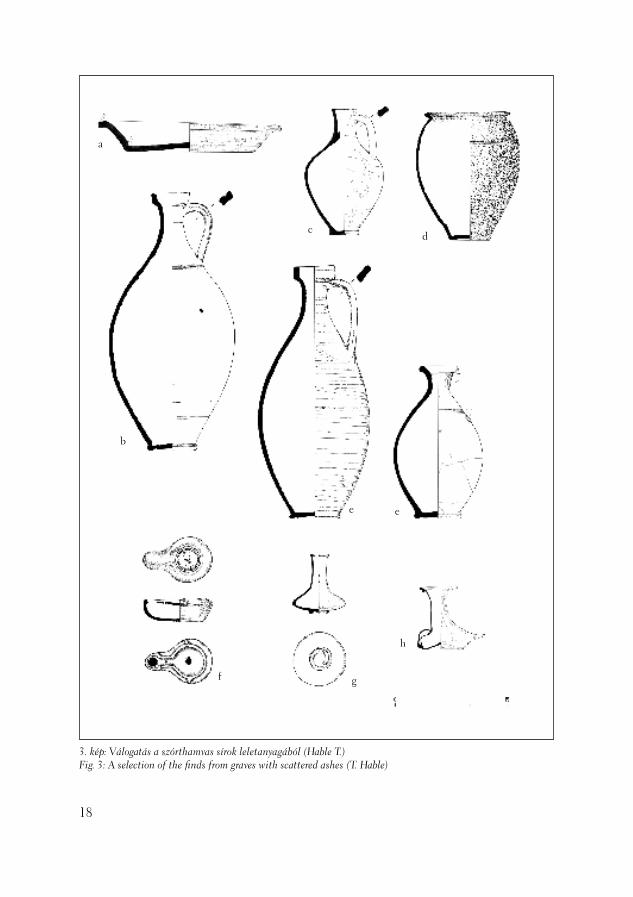
3. kép: Válogatás a szórthamvas sírok leletanyagából (Hable T.)Fig. 3: A selection of the fi nds from graves with scattered ashes (T. Hable)
a
b
cd
e e
f g
h
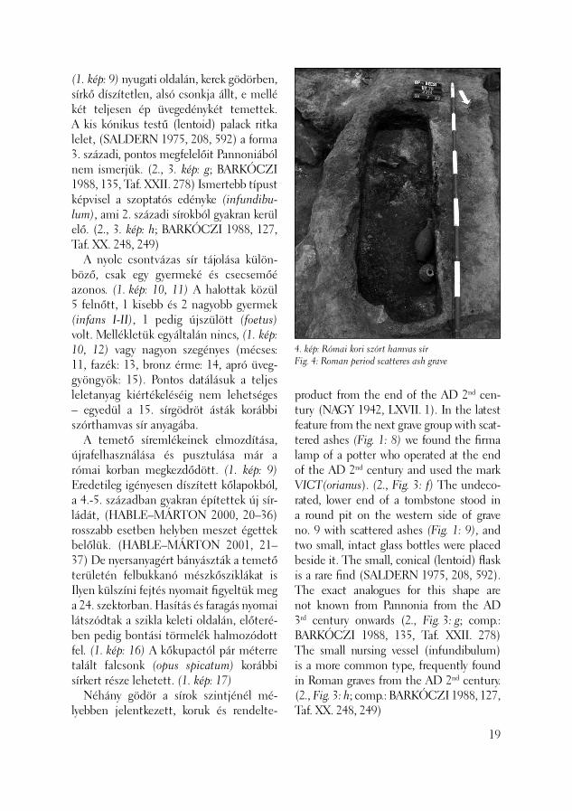
4. kép: Római kori szórt hamvas sírFig. 4: Roman period scatteres ash grave
(1. kép: 9) nyugati oldalán, kerek gödörben, sírkő díszítetlen, alsó csonkja állt, e mellé két teljesen ép üvegedénykét temettek. A kis kónikus testű (lentoid) palack ritka lelet, (SALDERN 1975, 208, 592) a forma 3. századi, pontos megfelelőit Pannoniából nem ismerjük. (2., 3. kép: g; BARKÓCZI 1988, 135, Taf. XXII. 278) Ismertebb típust képvisel a szoptatós edényke (infundibu-lum), ami 2. századi sírokból gyakran kerül elő. (2., 3. kép: h; BARKÓCZI 1988, 127, Taf. XX. 248, 249) A nyolc csontvázas sír tájolása külön-böző, csak egy gyermeké és csecsemőé azonos. (1. kép: 10, 11) A halottak közül 5 felnőtt, 1 kisebb és 2 nagyobb gyermek (infans I-II), 1 pedig újszülött (foetus) volt. Mellékletük egyáltalán nincs, (1. kép: 10, 12) vagy nagyon szegényes (mécses: 11, fazék: 13, bronz érme: 14, apró üveg-gyöngyök: 15). Pontos datálásuk a teljes leletanyag kiértékeléséig nem lehetséges – egyedül a 15. sírgödröt ásták korábbi szórthamvas sír anyagába. A temető síremlékeinek elmozdítása, újrafelhasználása és pusztulása már a római korban megkezdődött. (1. kép: 9) Eredetileg igényesen díszített kőlapokból, a 4.-5. században gyakran építettek új sír-ládát, (HABLE–MÁRTON 2000, 20–36) rosszabb esetben helyben meszet égettek belőlük. (HABLE–MÁRTON 2001, 21–37) De nyersanyagért bányászták a temető területén felbukkanó mészkősziklákat is Ilyen külszíni fejtés nyomait fi gyeltük meg a 24. szektorban. Hasítás és faragás nyomai látszódtak a szikla keleti oldalán, előteré-ben pedig bontási törmelék halmozódott fel. (1. kép: 16) A kőkupactól pár méterre talált falcsonk (opus spicatum) korábbi sírkert része lehetett. (1. kép: 17) Néhány gödör a sírok szintjénél mé-lyebben jelentkezett, koruk és rendelte-
product from the end of the AD 2nd cen-tury (NAGY 1942, LXVII. 1). In the latest feature from the next grave group with scat-tered ashes (Fig. 1: 8) we found the fi rma lamp of a potter who operated at the end of the AD 2nd century and used the mark VICT(orianus). (2., Fig. 3: f) The undeco-rated, lower end of a tombstone stood in a round pit on the western side of grave no. 9 with scattered ashes (Fig. 1: 9), and two small, intact glass bottles were placed beside it. The small, conical (lentoid) fl ask is a rare fi nd (SALDERN 1975, 208, 592). The exact analogues for this shape are not known from Pannonia from the AD 3rd century onwards (2., Fig. 3: g; comp.: BARKÓCZI 1988, 135, Taf. XXII. 278) The small nursing vessel (infundibulum) is a more common type, frequently found in Roman graves from the AD 2nd century. (2., Fig. 3: h; comp.: BARKÓCZI 1988, 127, Taf. XX. 248, 249)
19

20
tésük csak bizonytalanul defi niálható. (1. kép: 18) Három objektumban a késő-rézkor badeni típusú cserepeit találtuk. (1. kép: 19)
Hable Tibor
Irodalom/References:
BÓNIS 1947 – B. Bónis É.: A Bécsi-úti kora-római temető agyagedényei (La céramique du cinetière de Bécsi út de l’époque romai-ne). Antiquitas Hungarica 1(1947) 43–48.BARKÓCZI 1988 – Barkóczi, L.: Pannonis-che Glasfunde in Ungarn. Budapest, 1988. HABLE–MÁRTON 2000 – Hable T. – Már-ton A.: Sírok és sírkövek a Bécsi úti temető-ből (Graves and gravestones from the Bécsi Road cemetery), Aqfüz 6 (2000) 20–36.HABLE–MÁRTON 2001 – Hable T. – Márton A.: Újabb sírok az aquincumi katonaváros nyugati temetőjéből (Recently discovered from the Aquincum Military Town’s Western cemetery), Aqfüz 7 (2001) 21–37.KUZSINSZKY 1932 – Kuzsinszky B.: A gázgyári római fazekastelep Aquincumban. BudRég. 11. (1932)NAGY 1942 – Nagy L.: Temetők és temet-kezés. In Budapest története (Red. Szendy K.) Budapest az ókorban II. Budapest, 1942.SALDERN 1975 – Saldern, A. v. – Nolte, B. – La Baume, P. – Haevernick, Th. E.: Gläser der Antike. Sammlung Erwin Oppenländer. Red.: A. von Saldern, Köln, 1975TOPÁL 2003 – Topál, J.: Roman Cemete-ries of Aquincum, Pannonia. The Western Cemetery, Bécsi Road II. Budapest, 2003
The orientation of the eight inhumation graves was diverse. Only a child and a baby lay in graves with the same orientation (Fig. 1: 10, 11). Five of the deceased were adults, 1 was a small child, and 2 were older child-ren (infans I-II), while one was a new-born baby (foetus). They were not given grave goods (Fig. 1: 10, 12) or else the grave go-ods were very poor (a lamp: 11, a pot: 13, a bronze coin: 14, tiny glass beads: 15). It is not possible to provide an exact date until the entire fi nd material is analyzed. Only grave shaft no. 15 was dug into the material of an earlier grave with scattered ashes. The dislocation, secondary utilisation and destruction of the tombstones from the cemetery already started in the Roman period (Fig. 1: 9). Often in the AD 4th-5th centuries new sarcophagi were construc-ted from the originally fi nely fi nished and ornamented stone slabs of former graves (HABLE–MÁRTON 2000, 20–36). Even worse, lime was burnt out of them on lo-cation. (HABLE–MÁRTON 2001, 21–37) The limestone rocks were also present in the territory of the cemetery and were ex-poited for their raw material. The traces of an open quarry were observed in sector 24. The marks left by splitting and carving co-uld be seen on the eastern side of the rock, and quarry debris accumulated in front of this rock (Fig. 1: 16). The remains of a wall (opus spicatum) was found a few metres from the stone heap and may have been part of a former graveyard (Fig. 1: 17). A few pits appeared which were deeper than the level of the graves but their age and function cannot be certainly determi-ned (Fig. 1: 18). In three features we found sherds from the Late Copper Age Baden culture (Fig. 1: 19).
Tibor Hable

A Budapesti Műszaki Főiskola – a Felső-oktatási Reform Program keretében meg-valósuló – új oktatási létesítménye a Bécsi út 96/b. alatti egyesített ingatlanokon épül fel. A leendő épületek körülbelül 3100 négyzetméter nagyságú területén az épít-kezés megkezdése előtt régészeti feltárást folytattunk. A kutatásra 2003. április 9. – október 14. között került sor. A megvalósítandó épületegyüttes – a korábbi ásatások (FACSÁDY 2000, 2003, HABLE 2001, TOPÁL 1993, TOPÁL 2003) és az adattári adatok alapján – az úgynevezett Bécsi úti temető, a katonavá-ros nyugati temetőjének területén létesül, garázs-, illetve mélygarázs szintje a római kori objektumokat teljes mértékben meg-semmisíti. A feltárandó telkek a Bécsi úttól nyugat felé folyamatosan, majd meredekebben emelkednek, a munka során végzett geo-lógiai megfi gyelések azonban a maitól né-mileg eltérő korabeli terepviszonyokat rög-zítettek. Az utóbbi évszázad során végzett tereprendezések, építkezések nyomán a felszín kiegyenlítettebbé vált. Mindszenty Andrea és Horváth Zoltán geológusok földtani-talajtani megfi gyeléseit Krolopp Endre malakológiai vizsgálataival kiegészít-ve a terület őskörnyezeti rekonstrukciójára is lehetőség nyílt. (MINDSZENTY–HOR-VÁTH 2003) A bolygatatlan altalajt a
Temetőfeltárás a Bécsi úton
(Budapest, III. ker., Bécsi út 96/b., Hrsz.: 14724/1, 14721/2)
A new educational establishment, the Budapest Technical High School, will be realised within the framework of the Reform Project for Higher Education on connected lots at 96/b Bécsi Road. Ar-chaeological excavations were conducted prior to the start of the construction work on the approximately 3100 square metres territory of the planned buildings between April 9 and October 14, 2003. On the basis of previous excavation work (FACSÁDY 2000, 2003, HABLE 2001; TOPÁL 1993, 2003) and archival data, the building complex will fall in the area of the so-called Bécsi Road cemetery, the western cemetery of the Military Town. The deep parking garage will entirely destroy features from the Roman period. The investigated lots gradually, then steeply, rise westwards from Bécsi Road. The geological observations made during the course of the excavations, however, indicated that the contemporary relief was somewhat different from the modern one. Repeated landscaping and construc-tion levelled the surface in the last cen-tury. From Endre Krolopp’s malacological analyses and Andrea Mindszenty and Zoltán Horváth geologists’ geological and pedological observations, a complex envi-ronmental reconstruction could be made of the area (MINDSZENTY–HORVÁTH
Excavation at a cemetery in Bécsi Road
(Budapest III, 96/b Bécsi Road,Ln: 14724/1 and 14721/2)
21
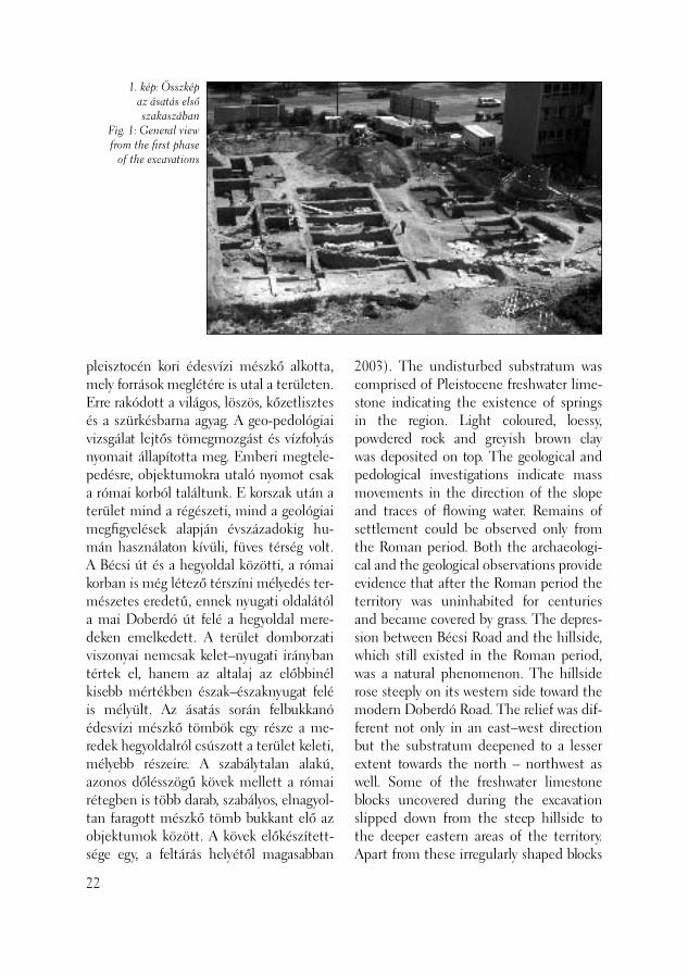
1. kép: Összkép az ásatás első szakaszában
Fig. 1: General view from the fi rst phase
of the excavations
pleisztocén kori édesvízi mészkő alkotta, mely források meglétére is utal a területen. Erre rakódott a világos, löszös, kőzetlisztes és a szürkésbarna agyag. A geo-pedológiai vizsgálat lejtős tömegmozgást és vízfolyás nyomait állapította meg. Emberi megtele-pedésre, objektumokra utaló nyomot csak a római korból találtunk. E korszak után a terület mind a régészeti, mind a geológiai megfi gyelések alapján évszázadokig hu-mán használaton kívüli, füves térség volt. A Bécsi út és a hegyoldal közötti, a római korban is még létező térszíni mélyedés ter-mészetes eredetű, ennek nyugati oldalától a mai Doberdó út felé a hegyoldal mere-deken emelkedett. A terület domborzati viszonyai nemcsak kelet–nyugati irányban tértek el, hanem az altalaj az előbbinél kisebb mértékben észak–északnyugat felé is mélyült. Az ásatás során felbukkanó édesvízi mészkő tömbök egy része a me-redek hegyoldalról csúszott a terület keleti, mélyebb részeire. A szabálytalan alakú, azonos dőlésszögű kövek mellett a római rétegben is több darab, szabályos, elnagyol-tan faragott mészkő tömb bukkant elő az objektumok között. A kövek előkészített-sége egy, a feltárás helyétől magasabban
22
2003). The undisturbed substratum was comprised of Pleistocene freshwater lime-stone indicating the existence of springs in the region. Light coloured, loessy, powdered rock and greyish brown clay was deposited on top. The geological and pedological investigations indicate mass movements in the direction of the slope and traces of fl owing water. Remains of settlement could be observed only from the Roman period. Both the archaeologi-cal and the geological observations provide evidence that after the Roman period the territory was uninhabited for centuries and became covered by grass. The depres-sion between Bécsi Road and the hillside, which still existed in the Roman period, was a natural phenomenon. The hillside rose steeply on its western side toward the modern Doberdó Road. The relief was dif-ferent not only in an east–west direction but the substratum deepened to a lesser extent towards the north – northwest as well. Some of the freshwater limestone blocks uncovered during the excavation slipped down from the steep hillside to the deeper eastern areas of the territory. Apart from these irregularly shaped blocks

2. kép: A vízvezeték részleteFig. 2: Detail of the water channel
fekvő kőbánya, illetve kőfaragó – előkészítő műhely meglétére utal, ahonnan a kövek a mélyebben fekvő temetőrész területére csúszhattak. A kutatást a tervezett épületegyüttes nyugati épülete alatt, annak északnyugati végén, a Doberdó út mellett kezdtük meg. Az itt húzott kutatóárokban vegyes, római-val kevert kerámiatöredékek kerültek elő, objektumot nem találtunk. Az épület déli oldalán további kutatóárokkal behatároltuk a római temetőt, mely késői szakaszában a hegyoldal meredek lejtőjére is felhúzódott. Ezzel párhuzamosan megkezdtük a Bécsi út mentén készülő épület alatti feltárás első, majd júniustól a második részét is. Az újkori épületalapok a római szintbe mélyedtek, középkori réteg nem volt. (A középkor jelenlétét csak két darab sérült, szórvány érem jelzi.) A terület legészakibb keskeny sávja a római temetőparcellán kívül esett. Itt a lejtőn lecsúszott és ter-mészetes alakulatú mészkövek felhaszná-lásával, kiegészítésével készült járószintek, forrásokra utaló nyomok kerültek elő. A feltárás során megtaláltuk a temető-rész nyugati és északi határát, amit egy-egy szárazfalazással készült, a korabeli terep-alakulatot követő, 80 centiméter vastag fal mutat. (1. kép) A kerítésfal mentén és a sírok között járófelületek, útrétegek rész-leteit bontottunk ki, helyenként a falazat megújítását, elplanírozását is megfi gyel-hettük. A temető nyugati oldalában öntött falazattal készült, terrazzóval bélelt vízve-zeték haladt, mely a Doberdó utca feletti hegyoldalban lévő források egyikének vizét szállíthatta dél felé. (2. kép) Munkaterü-letünk határain belül dokumentálhattuk, a vízvezeték észak–déli irányú szakaszán kívül, fordulásának ívét, s északnyugat–dél-keleti irányú, a hegyoldalba fúródó részét is kibontottuk. A vízvezeték a temető hasz-
which had a uniform inclination, numer-ous roughly dressed, regular limestone blocks were uncovered in the Roman layer between the features. The fact that the blocks were dressed suggests that a quarry and a workshop for the preparation and dressing of the rock existed at a higher elevation. The dressed blocks would have slipped down to the lower territory of this fragment of the cemetery. The investigations began under the western building of the future build-ing complex, at its northwestern end by Doberdó Road. The trench opened here contained sherds mixed with Roman pot-tery fragments although no feaures were found. The edge of the Roman cemetery, which climbed the steep hillside in its late phase, was found in another test trench. At
23

nálati ideje alatt épült meg, s a temetke-zések folytatódtak annak megszűnése után is. A temetőparcella hosszú ideig haszná-latban volt, a leletek alapján már a Kr. u. 2. század során temetkeztek itt, s folya-matosan kerültek földbe sírok a 4. század végéig, sőt valószínűleg az 5. század ele-jéig. A 2003. ásatási időszakban összesen 214 sírt bontottunk ki, s hamvasztásos és csontvázas rítusú temetkezéseket egyaránt feltártunk. A temetkezési mód rendkívül változatos volt. A legnagyobb számban (124 sír) szórthamvas sírok fordultak elő, de két urnasír is előkerült. A ham-vasztásos sírok között kőlapokkal fedett, kőpakolással borított változatok is voltak. Több sír oldalát kitapasztották. Néhány sír négyzet alakú, falazott sírkertben feküdt, négy ilyen jellegű temetkezés került elő. A csontvázas sírok többsége koporsó nélküli temetkezés volt, de hét darab tegulákból és hat kőlapokból összeállított sírt talál-tunk. A hosszú használati időt nemcsak a leletanyag bizonyítja, hanem a gyakori egymásra temetkezések is. A munka során több rétegben bukkantunk ezekre a sírok-
24
the same time, we initiated the fi rst phase of the excavation under the future build-ing on Bécsi Road, which was followed by the second phase of the work in June. The foundations of the modern houses extend-ed down into the Roman layer, while the medieval layers were missing. (Only two damaged, stray coins represented medieval times.) The northernmost, narrowest zone of this territory lay outside the Roman cemetery lot. Here, traces of fl oor levels made partly from the natural limestone blocks that had slipped down from the hillside as well as springs were uncovered. In the course of the excavations, we located the western and northern borders of the cemetery fragment, each edge with an 80 cm wide wall made in a dry-wall technique (Fig. 1). Both walls followed the contemporary relief. The fragments of fl oor levels and road layers were uncovered along the fencing wall and between the graves. At a few spots the renewal and the levelling of the wall could also be observed. An water conduit made of cast-in-situ walls and lined with terrazzo ran along the western side of the cemetery and carried
3. kép: Gyermeksírok játék melléklettelFig. 3: Toys as grave-goods from children’s graves
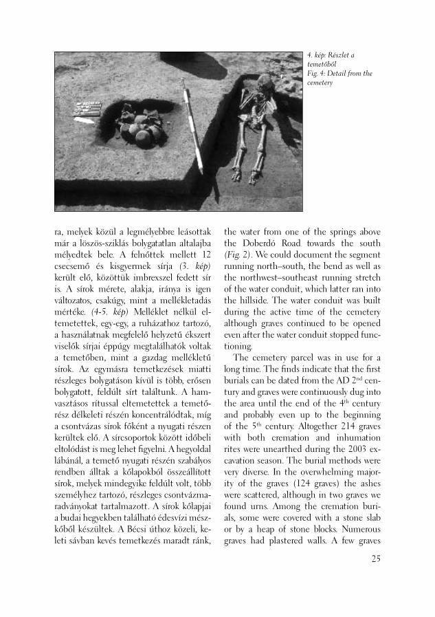
4. kép: Részlet a temetőbőlFig. 4: Detail from the cemetery
ra, melyek közül a legmélyebbre leásottak már a löszös-sziklás bolygatatlan altalajba mélyedtek bele. A felnőttek mellett 12 csecsemő és kisgyermek sírja (3. kép) került elő, közöttük imbrexszel fedett sír is. A sírok mérete, alakja, iránya is igen változatos, csakúgy, mint a mellékletadás mértéke. (4-5. kép) Melléklet nélkül el-temetettek, egy-egy, a ruházathoz tartozó, a használatnak megfelelő helyzetű ékszert viselők sírjai éppúgy megtalálhatók voltak a temetőben, mint a gazdag mellékletű sírok. Az egymásra temetkezések miatti részleges bolygatáson kívül is több, erősen bolygatott, feldúlt sírt találtunk. A ham-vasztásos rítussal eltemetettek a temető-rész délkeleti részén koncentrálódtak, míg a csontvázas sírok főként a nyugati részen kerültek elő. A sírcsoportok között időbeli eltolódást is meg lehet fi gyelni. A hegyoldal lábánál, a temető nyugati részén szabályos rendben álltak a kőlapokból összeállított sírok, melyek mindegyike feldúlt volt, több személyhez tartozó, részleges csontvázma-radványokat tartalmazott. A sírok kőlapjai a budai hegyekben található édesvízi mész-kőből készültek. A Bécsi úthoz közeli, ke-leti sávban kevés temetkezés maradt ránk,
the water from one of the springs above the Doberdó Road towards the south (Fig. 2). We could document the segment running north–south, the bend as well as the northwest–southeast running stretch of the water conduit, which latter ran into the hillside. The water conduit was built during the active time of the cemetery although graves continued to be opened even after the water conduit stopped func-tioning. The cemetery parcel was in use for a long time. The fi nds indicate that the fi rst burials can be dated from the AD 2nd cen-tury and graves were continuously dug into the area until the end of the 4th century and probably even up to the beginning of the 5th century. Altogether 214 graves with both cremation and inhumation rites were unearthed during the 2003 ex-cavation season. The burial methods were very diverse. In the overwhelming major-ity of the graves (124 graves) the ashes were scattered, although in two graves we found urns. Among the cremation buri-als, some were covered with a stone slab or by a heap of stone blocks. Numerous graves had plastered walls. A few graves
25
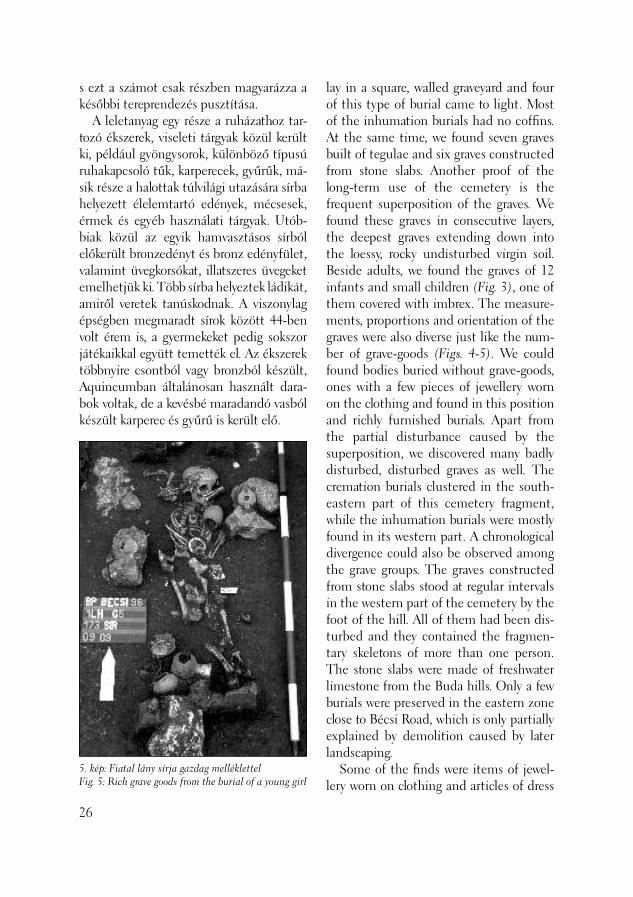
s ezt a számot csak részben magyarázza a későbbi tereprendezés pusztítása. A leletanyag egy része a ruházathoz tar-tozó ékszerek, viseleti tárgyak közül került ki, például gyöngysorok, különböző típusú ruhakapcsoló tűk, karperecek, gyűrűk, má-sik része a halottak túlvilági utazására sírba helyezett élelemtartó edények, mécsesek, érmek és egyéb használati tárgyak. Utób-biak közül az egyik hamvasztásos sírból előkerült bronzedényt és bronz edényfület, valamint üvegkorsókat, illatszeres üvegeket emelhetjük ki. Több sírba helyeztek ládikát, amiről veretek tanúskodnak. A viszonylag épségben megmaradt sírok között 44-ben volt érem is, a gyermekeket pedig sokszor játékaikkal együtt temették el. Az ékszerek többnyire csontból vagy bronzból készült, Aquincumban általánosan használt dara-bok voltak, de a kevésbé maradandó vasból készült karperec és gyűrű is került elő.
26
5. kép: Fiatal lány sírja gazdag melléklettelFig. 5: Rich grave goods from the burial of a young girl
lay in a square, walled graveyard and four of this type of burial came to light. Most of the inhumation burials had no coffi ns. At the same time, we found seven graves built of tegulae and six graves constructed from stone slabs. Another proof of the long-term use of the cemetery is the frequent superposition of the graves. We found these graves in consecutive layers, the deepest graves extending down into the loessy, rocky undisturbed virgin soil. Beside adults, we found the graves of 12 infants and small children (Fig. 3), one of them covered with imbrex. The measure-ments, proportions and orientation of the graves were also diverse just like the num-ber of grave-goods (Figs. 4-5). We could found bodies buried without grave-goods, ones with a few pieces of jewellery worn on the clothing and found in this position and richly furnished burials. Apart from the partial disturbance caused by the superposition, we discovered many badly disturbed, disturbed graves as well. The cremation burials clustered in the south-eastern part of this cemetery fragment, while the inhumation burials were mostly found in its western part. A chronological divergence could also be observed among the grave groups. The graves constructed from stone slabs stood at regular intervals in the western part of the cemetery by the foot of the hill. All of them had been dis-turbed and they contained the fragmen-tary skeletons of more than one person. The stone slabs were made of freshwater limestone from the Buda hills. Only a few burials were preserved in the eastern zone close to Bécsi Road, which is only partially explained by demolition caused by later landscaping. Some of the fi nds were items of jewel-lery worn on clothing and articles of dress

6. kép: A római kocsi sír kibontás közben a beleásott későrómai sírralFig. 6: The Roman wagon grave during cleaning with the Late Roman grave dug into it
A temető kiemelkedő jelentőségű lelete a 162. számú sír, mely, lovakkal együtt el-földelt római kocsi maradványait rejtette. A területen élő őslakosság, a kelta-eraviscu sok a halottak túlvilági utazását kocsin képzel-ték, s a rómaiaktól átvett szokásuk szerint állított sírköveiken ezt a jelenetet is megö-rökítették. Keveseknek jutott az a kiváltság, hogy megengedhették maguknak egy való-di, díszes kocsi – vagy részei – sírba vitelét. Kelet-Pannoniából több kocsitemetkezést vagy arra utaló nyomot ismerünk, városi környezetben, városi temetőben lévőt, il-letve aquincumit idáig azonban egyet sem. (PALÁGYI–NAGY 2000, 150; ZSIDI 2003, 57.) A temetkezésre a temető használatá-nak korai szakaszában kerülhetett sor, s egy 4. században eltemetett leány sírja csak kis részét rongálta meg. (6. kép) A körülbelül 3,6×3,6 méter méretű, a sziklák közé mélyített gödör északi oldalán voltak csak
e.g. necklaces, various brooches, bracelets, and fi nger-rings. Another part of the fi nds comprised vessels, lamps, coins and other articles of use intended to help the jour-ney made by the dead to the other world. Among the latter would be included a bronze vessel and a bronze vessel handle found in a cremation burial as well as glass jugs and scent bottles. Several graves contained caskets as suggested by the re-maining casket fi ttings. Forty-four of the relatively well preserved graves contained coins, while the children were often buried together with their toys. Most of the pieces of jewellery represent common artefacts in Aquincum. They could also be made of bone or bronze, although a few bracelets and rings made of less enduring iron were also found. The most signifi cant fi nd from the entire cemetery comes from grave no. 162,
27

7. kép: Részlet a kocsi sírból bontás közbenFig. 7: Detail from the cleaning of the wagon burial
égésnyomok. A fa részek szenesedésének mértékéből, a lómaradványok épségéből a máglya lefojtását feltételezhetjük. A kö-tőféken vezetett két lovat – egy fi atal, 3 és fél éves, és egy idős, 18 éves kancát (a lovak vizsgálatát, koruk és nemük megállapítását Lyublyanovics Kyra végezte, akinek mun-káját köszönöm) a helyszínen taglózták le, s dobták a sírgödörbe, a szétszedett kocsi részeivel egyidejűleg. A két ló a gödörbe kerülés pillanatában még mozgott, egyikük oldalán feküdt, a másik részben az előbbin, „rogyasztott” pózban. A kocsi részei közül néhány darab, így az egyik kerék egy része is, a lovak alá került. Az ásatás során tett megfi gyelések alapján egy négykerekű, kevés bronz díszítménnyel ellátott kocsi került a sírba. Az igen nagy nedvességtar-talmú talaj miatt vas alkatrészei erősen korrodáltak, rossz megtartásúak, formájuk kivehetetlen. A jelenleg restaurálás alatt lévő darabok elkészültével nyílik mód a kocsi rekonstruálására, pontos keltezésére. (7. kép) A temető használati idejének másik végpontjaként említhetjük a hegyoldal lábánál épségben fekvő női csontvázat, melynek ujján jelentéktelen kinézetű, egyszerű bronz gyűrű volt. A gyűrű felirata – IHS- bizonyítja, hogy viselője keresztény-nek vallotta magát. A feltárás munkái során az ásatás le-bonyolításában Anderkó Krisztián ásatási technikus volt segítségemre.
R. Facsády Annamária
28
Irodalom/References:
FACSÁDY 2000 – Facsády A.: Leletmenté-sek az ún. Bécsi úti temető északi részén. (Rescue Excavations in the Northern Part
which contained the remains of a Roman cart buried together with the horses which pulled it. The Celtic Eraviscans, the au-tochtonous population in this territory, be-lieved that the dead journeyed to the other world on carts. This scene was depicted on the tombstones they raised according to a custom borrowed from the Romans. Very few could actually be privileged enough to take their real, ornamental cart or even parts of it into the grave. We know of a few cart burials or traces of them from Eastern Pannonia, but none from a city, in a municipal cemetery setting (PALÁ-GYI–NAGY 2000, 150; ZSIDI 2003, 57). The burial must have taken place in the early phase of the cemetery. The grave of a girl buried in the AD 4th century dam-aged only a small portion of this grave (Fig. 6). The only traces of burning were found
of the so-called Bécsi Street Cemetery.) Aqfüz 6 (2000) 56–61.FACSÁDY 2003 – Facsády A.: Szondázás a Bécsi úti temető északi részén. (Test exca-vatioin in the northern part of the ceme-tery on Bécsi road.) Aqfüz 9 (2003) 65–68.HABLE–MÁRTON 2001 – Hable T. – Márton A.: Újabb sírok az aquincumi katonaváros nyugati temetőjéből. (New graves from the western cemetery of the Aquincum Military Town.) Aqfüz 7(2001) 21–37.MINDSZENTY–HORVÁTH 2003 – Mindszenty A. – Horváth Z.: Az Óbuda/Bécsi út 96. régészeti ásatás geo-pedológiai vizsgálata, Budapest, kézirat.PALÁGYI–NAGY 2000 – K. Palágyi S. – Nagy L.: Római kori halomsírok a Du-nántúlon, Veszprém, 2000TOPÁL 1993 – Topál J.: Roman Cemetery of Aquincum, Pannonia. The Western Cemetery (Bécsi road) I. Aquincum Nost-rum I. Budapest, 1993TOPÁL 2003 – Topál J.: Roman Cemetery of Aquincum, Pannonia. The Western Cemetery (Bécsi road) II. Aquincum Nostrum I.2. Budapest, 2003ZSIDI 2003 – Zsidi P.: Die Frage der Hü-gelgrab- und Wagenbestattungen in Aqu-incum, Libelli Archaeologici Ser. Nov. No. 1. Pannonica Provincialia et Archaeologia. Budapest, 2003, 57–80.
in the northern part of the approximately 3.6×3.6 m large pit dug down between rocks. The degree to which the wooden el-ements were charred and the intact condi-tion of the horse remains suggest that the pyre had been smothered. The two horses led by their bridles included a young 3.5 year old individual and an older, 18 year old mare (Kyra Lyublyanovics examined the horses and determined their age and sex. I thank her for her work.) were slaugh-tered on the spot and thrown into the pit together with elements from the disman-tled cart. The two horses were still moving when they were thrown into the pit. One horse lay on its side while the other lay partly on her in a “prostrate” position. Some elements of the cart, like part of one of the wheels remained stuck under the horses. The observations made during the excavation suggest that the four-wheeled cart was placed into the grave with only a few of its bronze ornaments. Due to the high humidity of the soil, the iron ele-ments were strongly corroded and poorly preserved so that their shapes could not be determined. After the restoration of these items the cart will be reconstructed and more precisely dated (Fig. 7). The other chronological limit of the ac-tive period of the cemetery is set by the intact inhumation grave of a woman lying at the foot of the hill. She had a simple, seemingly insignifi cant bronze ring on her fi nger. This ring bore the inscription IHS and shows that the woman considered herself a Christian. Krisztián Anderkó, excavation techni-cian, helped me with the work during the excavation.
Annamária R. Facsády
29

A 2003 januárjában megkutatott telek Aquincum katonavárosának déli szélén fekszik, a katonaváros észak–déli főútja, a limesút és a katonai amfi teátrum között. Az Amfi -Apartman Kft. megbízásából végeztünk megelőző feltárást az 1. szá-zad végi – 2. század eleji telepjelenségek megfi gyelésére, kiegészítve az 1989–1991 között folytatott régészeti feltárást. (MA-DARASSY 1991, 25; MADARASSY 1993, 34) Az 1989–1991 ásatáson a limesútról a katonai amfi teátrumba vezető bekötőút, a mellette épült hosszúházak, valamint néhány, a limesútra nyíló lakóház hátulsó, nyugati lezárása került elő. Az épületek nagy építési periódusai megfelelnek a le-giótábor építési periódusainak. A limesút kiépítése a Domitianus kori palánkszer-kezetű legiótábor létesítéséhez köthető, a 2. század elején a tábor és a körülötte lévő katonaváros egységes központi vá-rosrendezési koncepció alapján épült át. Ezen a telken is ekkor alakult ki a későbbi insula szerkezete. A 3. század folyamán a legiótábort majd a katonaváros épületeit megújították, korszerűsítették. A katona-városban az addig szabad területeket, így az itt feltárt insula központi udvarát is egyre jobban beépítették. A lakó negyedet a katonaváros megszűntekor, a 3. század végén hagyták el, a 4. században a terü-
Korai telepjelenségek kutatása az aquincumi canabae déli régiójában
(Budapest, III. ker., Pacsirtamező utca 3–11/a, Hrsz.: 17804)
30
The investigation of the early periods in the southern section of the Aquincum canabae
(Budapest III, 3–11/a Pacsirtamező Street, Ln: 17804)
The lot, investigated in January 2003, can be found at the southern edge of the Military Town of Aquincum, between the north–south main road of the Mili-tary Town, the limes road and the mili-tary amphitheatre. Excavation preceding construction work was conducted at the commission of the Amfi -Apartman Kft. with the purpose of recording settlement features from the end of the AD 1st and the beginning of the 2nd centuries thus, complementing the archaeological exca-vations conducted in the area between 1989 and 1991 (MADARASSY 1991, 25; MADARASSY 1993, 34). The excavations between 1989 and 1991 unearthed the approach road from the limes road to the military amphi-theatre, long houses along this road and the back side or western end of a few residential houses opening onto the limes road. The major construction periods of the buildings were identical with the construction periods of the legionary fortress. It is a well-known fact that the construction of the limes road can be linked with the establishment of the plank-structure legionary fortress dating from the rule of Domitian. The fortress and the surrounding Military Town itself were developed according to a unifi ed central development concept at
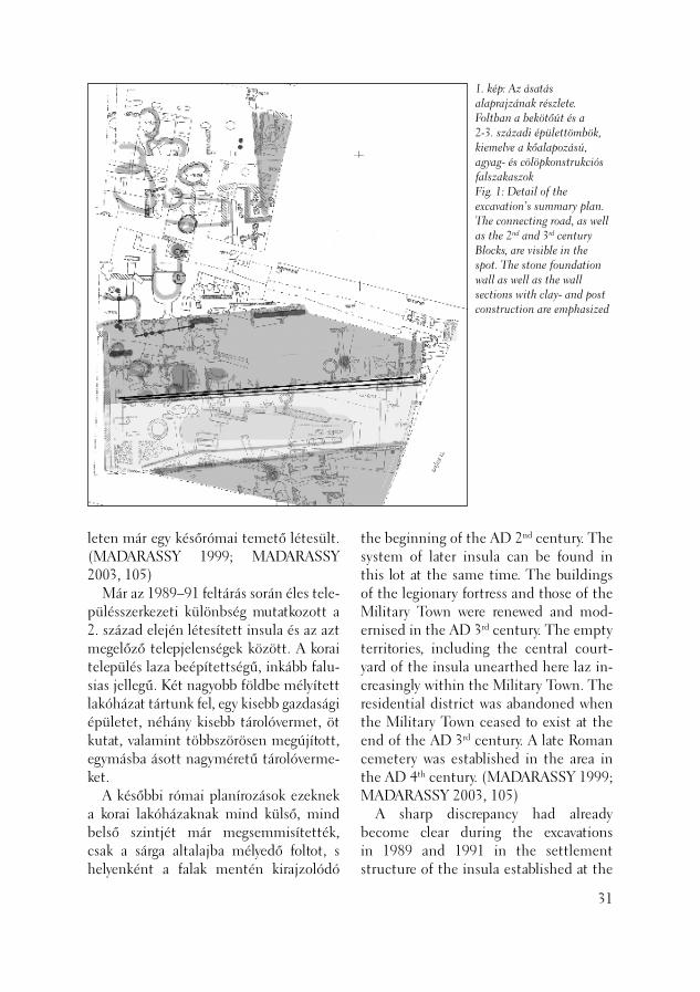
1. kép: Az ásatás alaprajzának részlete. Foltban a bekötőút és a 2-3. századi épülettömbök, kiemelve a kőalapozású, agyag- és cölöpkonstrukciós falszakaszokFig. 1: Detail of the excavation’s summary plan. The connecting road, as well as the 2nd and 3rd century Blocks, are visible in the spot. The stone foundation wall as well as the wall sections with clay- and post construction are emphasized
leten már egy későrómai temető létesült. (MADARASSY 1999; MADARASSY 2003, 105) Már az 1989–91 feltárás során éles tele-pülésszerkezeti különbség mutatkozott a 2. század elején létesített insula és az azt megelőző telepjelenségek között. A korai település laza beépítettségű, inkább falu-sias jellegű. Két nagyobb földbe mélyített lakóházat tártunk fel, egy kisebb gazdasági épületet, néhány kisebb tárolóvermet, öt kutat, valamint többszörösen megújított, egymásba ásott nagyméretű tárolóverme-ket. A későbbi római planírozások ezeknek a korai lakóházaknak mind külső, mind belső szintjét már megsemmisítették, csak a sárga altalajba mélyedő foltot, s helyenként a falak mentén kirajzolódó
the beginning of the AD 2nd century. The system of later insula can be found in this lot at the same time. The buildings of the legionary fortress and those of the Military Town were renewed and mod-ernised in the AD 3rd century. The empty territories, including the central court-yard of the insula unearthed here laz in-creasingly within the Military Town. The residential district was abandoned when the Military Town ceased to exist at the end of the AD 3rd century. A late Roman cemetery was established in the area in the AD 4th century. (MADARASSY 1999; MADARASSY 2003, 105) A sharp discrepancy had already become clear during the excavations in 1989 and 1991 in the settlement structure of the insula established at the
31

karólyukakat dokumentálhattuk. A dé-lebbi lakóháznál belső osztás nyomait, az északinál esetleges megújítás nyomát fi gyelhettük meg. Az amfi teátrumba veze-tő út alatt keréknyomos földút részleteit tártuk fel, valamint több, a köves útnál korábbi vízelvezető árkot. A telket az 1989–91-es feltárás után nem építették be, 1996-ban az ásatási árkokat visszatöltötték és felszíni parkolót alakítottak ki. Csak 2003-ban nyílt lehető-ségünk a beépítés előtt a korai jelenségek megfi gyelésére, valamint az amfi teátrum-ba vezető bekötőút korábbi fázisainak feltárására. A terület mikrodomborzati viszonyai, enyhe észak–déli lejtése miatt csak az út déli oldalán ástak nyitott, csa-padékelvezető vizesárkot. Két, egymást kiváltó árkot fi gyeltünk meg. A bekötőút nyugati felén a köves-sóderes 2.-3. száza-di útalapozás alatt egy korábbi sóderes útfelszín került elő. (3. kép) Ezt az utat szegélyezte a délebbi vizesárok, az északi vizesárok pedig a földúthoz tartozhatott.
32
2. kép: Agyagfal nyomaFig. 2: Traces of a clay wall
beginning of the AD 2nd century and the former settlement features. The earlier settlement comprised loosely structured rural features. Two large semi-subter-ranean dwellings, a smaller economic out-building, a few smaller storage pits, fi ve wells and large, repeatedly renovated storage pits dug into each other were un-earthed. Later Roman landscaping events de-stroyed both the exterior and interior fl oor levels of these early dwellings. Only a pit sunk into the yellow virgin soil and sometimes the postholes along the walls could be documented. Traces of interior partitioning could be observed in the southern house and traces of oc-casional renovation in the northern one. Segments of a dirt road with remains of wheel ruts were uncovered under the road leading to the amphitheatre, as well as a few water channels which were earlier than the paved road. The lot was not built in after the excavations in 1989–91, the excavation trenches were refi lled in 1996 and an above ground parking garage was estab-lished. It was only in 2003 that we had occasion to observe the early features be-fore the construction and to unearth the early phases of the approach road to the amphitheatre. Because of the micro-relief conditions, a slight north–south slope to the territory, an open water channel was dug to carry away the rain water only on the southern side of the road. We observed two ditches that replaced each other. An earlier gravely road surface appeared under the stony-gravely road foundation of the AD 2nd-3rd centuries in the western half of the approach road (Fig. 3). The southern water channel ran along this road, while the northern water
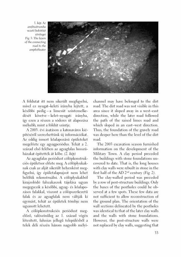
3. kép: Az amfi teátrumba vezető bekötőút
útrétegeiFig. 3: The layers of the connecting
road to the amphitheater
A földutat itt nem sikerült megfi gyelni, mivel ez nyugat–keleti irányba lejtett, a későbbi pedig – a limesút szintemelke-dését követve – kelet–nyugati irányba, így ezen a részen a sóderes út alapozása mélyebb, mint a földút szintje. A 2003. évi ásatáson a katonaváros kié-pítéséről szerezhettünk új információkat. Az eddig ismert kőalapozású épületeket megelőzte egy agyagperiódus. Tehát a 2. század első felében az agyagfalas hosszú-házakat építették át kőbe. (2. kép) Az agyagfalas periódust cölöpkonstruk-ciós épületsor előzte meg. A cölöplyukak-nak csak az alját sikerült helyenként meg-fi gyelni, így épületalaprajzot nem lehet belőlük rekonstruálni. A cölöplyukakból kirajzolódó falszakaszok tájolása ugyan megegyezik a későbbi, agyag- és kőalapo-zásos falakkal, viszont a cölöpszerkezetű falak és az agyagfalak nem váltják ki egymást, tehát az épületek tömbje nem ugyanott lehetett. A cölöpkonstrukciós periódust meg-előző, valószínűleg az 1. század végén létesített, falusias jellegű településből a telek déli részén három nagyobb mélyí-
channel may have belonged to the dirt road. The dirt road was not visible in this area since it sloped away in a west–east direction, while the later road followed the path of the raised limes road and which sloped in an east–west direction. Thus, the foundation of the gravely road was deeper here than the level of the dirt road. The 2003 excavation season furnished information on the development of the Military Town. A clay period preceded the buildings with stone foundations un-covered to date. That is, the long houses with clay walls were rebuilt in stone in the fi rst half of the AD 2nd century (Fig. 2). The clay-walled period was preceded by a row of post-structure buildings. Only the bases of the postholes could be ob-served at a few spots. These few data are not suffi cient to allow reconstruction of the ground plan. The orientation of the wall sections delineated by the postholes was identical to that of the later clay walls and the walls with stone foundations. However, the post-structure walls were not replaced by clay walls, suggesting that
33

tett verem került elő, két gabonatároló, egy kisebb verem, valamint egy kút. Mivel a területen a 2. század elejétől a 3. század második feléig folyamatos az építkezés, az ezzel járó tereprendezések következtében a korai objektumokhoz köthető zárt lelet-anyag nem került elő, a legkorábbi lelet-együttesek is csak a 2. század első felére keltezhetőek. (4. kép) A telek északnyugati felén a 19. század végétől a 20. század elejéig, a Spitzer Gerzson kékfestőműhelyéből kiépü lő Pamutnyomó Rt. textilfestő kádjait dokumentáltuk. A textilműhely alatt a sekélyebb alapozású jelenségek már meg-semmisültek, így itt csak a mélyebb római tárolóvermeket fi gyelhettük meg. (5. kép) Előkerült egy újabb fahordós kút, melyből római famaradványt sikerült kiemelni. Az 1991-ben feltárt földbe mélyített háztól délre kisebb gazdasági épület ki-dőlt agyagfalait és agyagtéglás betöltését dokumentáltuk. Ezt a gazdasági épületet megelőzte a területen feltárt legkorábbi objektum, egy északkelet–délnyugati irányú kettős vizesárok alja, mely tájolása alapján nem ehhez a települési fázishoz
34
the building blocks could not have occu-pied the same place. Three large storage pits, two cereal containers, a smaller pit and a well were uncovered in the southern part of the lot. They belonged to the rural settlement which existed here before the post-struc-ture period settlement, probably estab-lished at the end of the AD 1st century. Since building activity was continuous in this area from the beginning of the AD 2nd century until the second half of the 3rd century, the coeval landscaping activities preceding the constructions meant we could not fi nd closed fi nd ma-terials associated with the early features. Even the earliest fi nd assemblages could be dated only from the fi rst half of the 2nd century (Fig. 4). In the northwest half of the lot, we could document the textile dying vats of the Pamutnyomó Rt., which evolved out of Gerzson Spitzer’s blue dye textile workshop. The traces of shallower founda-tions had been destroyed under the tex-tile works, so that only the deeper Roman storage pits were still preserved (Fig. 5).
4. kép: A korai település tárolóverme, cölöpkonstrukciós falszakasz, kőalapozású falszakaszFig. 4: Storage pit from the early settlement. Wall sections with post-construction and stone foundations
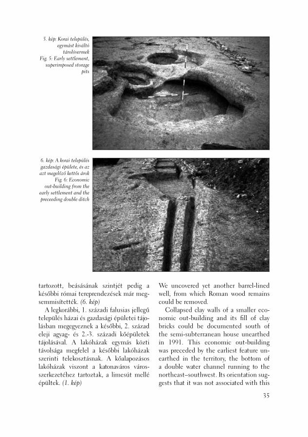
5. kép: Korai település, egymást kiváltó
tárolóvermekFig. 5: Early settlement,
superimposed storage pits
6. kép: A korai település gazdasági épülete, és az azt megelőző kettős árok
Fig. 6: Economic out-building from the
early settlement and the preceeding double ditch
tartozott, beásásának szintjét pedig a későbbi római tereprendezések már meg-semmisítették. (6. kép) A legkorábbi, 1. századi falusias jellegű település házai és gazdasági épületei tájo-lásban megegyeznek a későbbi, 2. század eleji agyag- és 2.-3. századi kőépületek tájolásával. A lakóházak egymás közti távolsága megfelel a későbbi lakóházak szerinti telekosztásnak. A kőalapozásos lakóházak viszont a katonaváros város-szerkezetéhez tartoztak, a limesút mellé épültek. (1. kép)
We uncovered yet another barrel-lined well, from which Roman wood remains could be removed. Collapsed clay walls of a smaller eco-nomic out-building and its fi ll of clay bricks could be documented south of the semi-subterranean house unearthed in 1991. This economic out-building was preceded by the earliest feature un-earthed in the territory, the bottom of a double water channel running to the northeast–southwest. Its orientation sug-gests that it was not associated with this
35

Egyetlen eltérő tájolású objektum a relatíve legkorábbi kettős vízelvezető árok, melyről feltételezhető hogy a legiótábor és a katonaváros kiépítése előtt, a Kr. u. 73-ban létesítet auxiliaris tábor körüli településhez, a vicus militarishoz tartoz-hatott.
Madarassy Orsolya
36
Irodalom/References:
MADARASSY 1991 – Madarassy O.: Régé-szeti Füzetek 1/43 (1991) 25. Nr. 47/15MADARASSY 1993 – Madarassy O.: Régé-szeti Füzetek 1/45 (1993) 34. Nr. 49/5.MADARASSY 1999 – Madarassy O.: Canabae legionis II Adiutricis. Roman Frontier Studies 17. Zalau, 1999MADARASSY 2003 – Madarassy O.: Die Canabae Legionis. In: Forschungen in Aquincum 1969–2002 (2003)
settlement phase although the level into which it was dug was obliterated by later Roman landscaping (Fig. 6). The orientation of the houses and eco-nomic out-buildings from the earliest, rural settlement from the AD 1st century is identical to that of the clay buildings from the beginning of the AD 2nd cen-tury and the stone buildings from the AD 2nd and 3rd centuries. The distance between the dwellings was also identical to the lot distribution of later residential houses. The residential houses with stone foundations, however, were part of the town structure of the Military Town and were built along the limes road (Fig. 1). The only feature with a different ori-entation was the relatively oldest double drainage ditch. It probably belonged to the vicus militaris, the settlement that evolved around the auxiliary fort estab-lished in AD 73 before the construction of the legionary fortress and the sur-rounding Military Town.
Orsolya Madarassy

Az öböl nyugati partfalában a helytartói palota főépületétől kissé délkeletre először 2000-ben (NÉMETH 2001) fi gyeltek meg és mértek fel sorosan elhelyezkedő mint-egy 120 cölöpöt. Már akkor feltételezhető volt, hogy ezek a római kori helytartói palota előterében, a parti védmű, vagy a kikötő részei lehettek. 2003-ban ideiglenes vízisípályát létesí-tettek a Hajógyári-öbölben, ehhez kapcso-lódva több alkalommal végeztünk régészeti megfi gyelést és dokumentálást. Áprilisban a Duna rendkívül alacsony vízállásánál, a szárazon lévő partoldalban került sor a vízisípálya kötéltartó oszlopainak helyén megfi gyelésre Németh Margit és Kirchhof Anita vezetésével. (Lásd e kötet rövid je-lentését.) Ugyanekkor a víz alatti részeken búvárrégészeti munkák is folytak Tóth J. Attila irányításával. (KÉRDŐ–TÓTH 2003) Szúrópróbaszerűen sor került dend-rokronológiai minták vételére. A vizsgálato-kat Grynaeus András végezte. Szeptember elején a Duna vízállása rendkívül alacsony volt (136-74 centiméteres vízszint Buda-pestnél 2003. szeptember 2. és 9. között). Ekkor H. Kérdő Katalin irányításával meg-történt a cölöpök és a búvárok által ápri-lisban víz alatt felmért kőobjektumok újra felmérése, fotózása. (HKK) 2003. április 7–9. között a Kulturális Örökségvédelmi Hivatal előírása alapján
Régészeti kutatások a Hajógyári-öbölben
(Budapest, III. ker., Óbudai-sziget, Hajógyári-öböl, Hrsz.: 23799)
Archaeological investigations in the Hajógyári-cove
(Budapest III, Óbuda Island, Hajógyári-cove, Ln: 23799)
Approximately 120 posts aligned in a singe row were fi rst observed and surveyed in 2000 somewhat to the southeast of the proconsul’s palace in the wall of the riverbank on the western side of the bay (NÉMETH 2001). Already at that time it was assumed that they belonged to a river-side defensive structure or a harbor dock from the Roman period located in the foreground of the proconsul’s palace. A temporary water ski course was estab-lished in the Dockyard Bay and we used this occasion to survey and document the site several times. In April, when the water level of the Danube was extremely low, we were able to make observations in the dry bank where the rope for the water skiing course was tied to a post. Margit Németh and Anita Kirchhof directed the survey (see the short report in this volume). At the same time, underwater archaeological survey was also carried out, directed by Attila J. Tóth (KÉRDŐ–TÓTH 2003). Random samples of wood from the posts were taken for dendrochronological analy-ses carried out by András Grynaeus. The water level of the Danube was extremely low at the beginning of September (136-74 cm at Budapest between September 2 and 9, 2003). During this period, the posts and the stone features surveyed as having been previously under water were
37
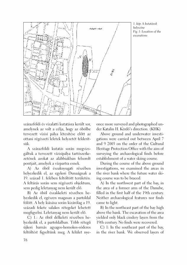
„A”
1. kép: A kutatások helyszíneFig. 1: Location of the excavations
„B”
„C1”„C2”
szárazföldi és vízalatti kutatásra került sor, amelynek az volt a célja, hogy az öbölbe tervezett vízisí pálya létesítése előtt az ottani régészeti leletek helyzetét felderít-sük. A szárazföldi kutatás során megvizs-gáltuk a tervezett vízisípálya tartószerke-zetének azokat az alábbiakban felsorolt pontjait, amelyek a vízpartra esnek. A) Az öböl északnyugati részében helyez kedik el, az egykori Dunaágnak a 19. század 1. felében feltöltött területén. A feltárás során sem régészeti objektum, sem pedig leletanyag nem került elő. B) Az öböl északkeleti részében he-lyezkedik el, egészen magasan a partoldal fölött. A hely kiásása során kizárólag a 19. századi fekete salakos rétegeket lehetett megfi gyelni. Leletanyag nem került elő. C) 1.: Az öböl délkeleti részében he-lyezkedik el, a partoldalban. Több rétegű újkori barnás agyagos-homokos-sóderos feltöltést fi gyeltünk meg. A felület nye-
38
once more surveyed and photographed un-der Katalin H. Kérdő’s direction. (KHK) Above ground and underwater investi-gations were carried out between April 7 and 9 2003 on the order of the Cultural Heritage Protection Offi ce with the aim of surveying the archaeological fi nds before establishment of a water skiing course. During the course of the above ground investigations, we examined the areas in the river bank where the future water ski-ing course was to be braced. A) In the northwest part of the bay, in the area of a former arm of the Danube, fi lled in the fi rst half of the 19th century. Neither archaeological features nor fi nds came to light. B) In the northeast part of the bay high above the bank. The excavation of the area yielded only black cindery layers from the 19th century. No fi nds were recovered. C) 1: In the southeast part of the bay, in the river bank. We observed layers of
sésekor sem mutatkozott semmiféle régé-szeti jelenség és leletanyag. C) 2.: Az öböl délkeleti részében helyez-kedik el, a partoldal tetején. Az előző rétegsorhoz hasonló újkori feltöltés jelent-kezett, mindennemű jelenség vagy lelet nélkül. A délnyugati sarokpont kiemelésére és bebetonozására szabálytalanul, előzetes bejelentés és régészeti felügyelet megke-rülésével került sor. A feltárással egyidőben csatornaépítés is folyt a múzeum által kutatott terület közelében. Az árok metszetében sóderes járószint mutatkozott, talán egy észak–dé-li irányú körülbelül 3,5–4 méter széles római úttal számolhatunk az öböl partja mentén. A kutatások eredménye alapján az öböl nyugati partján és a meder nyugati felében római kori cölöprendszer húzódik, amely az ott lévő helytartói palota előtti kikötő részét képezhette. A lelőhely 230 méter hosszan és 20 méter szélességben fi gyelhe-tő meg a nyugati part mentén. A régészeti objektumok megjelenésének keleti határa
2. kép: Cölöpök a Hajógyári-öböl nyugati partjánFig. 2: Posts on the western bank of the Hajógyári-cove
modern, brownish, clayey-sandy-gravelly fi ll. No archaeological feature or fi nds ap-peared when the surface was scraped. C) 2: In the southeast part of the bay, on top of the bank. A modern fi ll similar to the one described above was found lacking features or fi nds. The southwest corner point was lifted and fi lled in with concrete without autho-rization, by-passing a preliminary report to the museum and archaeological super-vision. In parallel to the excavation, a chan-nel was constructed near the area the museum was investigating. A gravelly fl oor level could be seen in the section of the trench so a 3.5–4 m wide Roman road can perhaps be expected running in a north-south direction along the bank of the bay. The results of the investigations tell us that a post construction from the Roman period extends along the western bank of the bay and in the western part of the ba-sin. This may have comprised part of the harbor in front of the proconsul’s palace. The site stretches 230 m lengthwise along
39

3. kép: A cölöpök és a köztük lévő mészkőtömbök alacsony vízállásnál (Gryneus András felvétele)Fig. 3: The posts and between them the blocks of limestone as seen at low water (photo by András Gryneus)
a szerelőcsarnoktól 125 méterig nyúlik. A legmagasabban megmaradt cölöp tetejé-nek szintadata 98, 6 m Af. (NM–KA) 2003. április 7–9. között víz alatti fel-derítést és felmérést végeztünk. A munka célja a tervezett vízisípálya területén a korábbi helyszíni szemléken megfi gyelt cölöpszerkezetű építmény kiterjedésének és jellegének tisztázása volt. A merülések során megállapítottuk, hogy a cölöpszerke-zetű építmény az öböl nyugati partjához kapcsolódik, a golfpálya vonalától északra a hajógyár sólyái elpusztították, az öböl déli oldalán pedig a beton támfal vona-lától kikotorták. A partra merőlegesen húzódó 15 méter hosszú cölöpsorokat dokumentáltuk, melyekben a cölöpsorok párosával (egymástól mintegy 2 méterre) helyezkedtek el, a párok között pedig 6–8 méter volt a távolság. A cölöp-párok között és körül nagy mennyiségű mészkő tömböt fi gyeltünk meg. Két szondát nyitottunk a terület déli részén. Megfi gyeltük, hogy a cölöpsorokat vízszintesen lefektetett gerenda kötötte össze, így 2×2 méteres
40
a 20 m wide strip on the bay’s western bank. The eastern border of the archaeo-logical features extends 125 m from the assembly hall. The top of the post that was preserved to the greatest height provided a datum of 98.5 meters above the Atlantic Ocean. (MN–AK) Underwater prospecting and survey were carried out between April 7 and 9, 2003. The purpose was to clarify the ex-tent and character of the post-structure construction observed earlier in the area of the future water skiing course. We found that the post-structure construc-tion is connected to the western wall of the bay. The dry docks of the modern dockyard destroyed it north of the golf course, while it was dredged on the southern side from the line of the con-crete retaining wall. The 15 m long post rows running perpendicular to the bank were documented. The posts stood in pairs (about 2 meters from one another) and there were 6-8 meters between pairs. Many limestone blocks were observed be-
keszon-szerű dobozokat hoztak létre. A cölöpök és a gerendák közötti területet mészkővel töltötték fel. A lelőhely minden részéről gyűjtöttünk fa mintát dendro-kronológiai elemzésre. Grynaeus András a tölgyfa cölöpöket Kr. u. 126 körülre keltez-te. A cölöpszerkezetű építmény a helytar-tói palota rakpartja lehetett. Fontos még megjegyezni, hogy néhány helyen látszott, hogy a cölöpsorok feltehetően még folyta-tódtak kelet felé, de felmérésükhöz a rájuk rakódott iszapot el kellett volna távolítani. (TJA)
H. Kérdő Katalin – Tóth János Attila – Németh Margit – Kirchhof Anita
Irodalom/References:
NÉMETH 2001 – Németh M.: Budapest, III. ker., Hajógyár-sziget (Hrsz.: 18386/1). (Budapest III, Hajógyár-sziget) Aqfüz 7 (2001) 141–142.KÉRDŐ–TÓTH 2003 – H. Kérdő K. – Tóth J. A.: Római kori rakpart marad-ványai a Hajógyári-öbölben. (Régészeti értékeink – a Kulturális Örökségvédelmi Hivatal kiadványa) [Roman quay at the Governor’s Palace of Aquincum, Budapest (Treasures of Archaeology in Hungary– a publication of the National Offi ce for the Protection of Cultural Heritage)] Buda-pest, 2003
tween and around the post pairs. Two test trenches were opened in the southern part of the territory. We observed that horizon-tally laid timbers connected the post rows, creating caisson-type coffers. The area between the posts and the timbers was fi lled in with limestone. Wood samples were taken from every part of the site for dendrochronological analyses. András Grynaeus dated the oak posts from about AD 126. The post-structure construction may have part of the landing wharf for the proconsul’s palace. It is important to add that the post rows probably extended farther to the east, as could be observed in certain places. However, it will be neces-sary to remove the loam to survey them properly. (AJT)
Katalin H. Kérdő – Attila János Tóth– Margit Németh – Anita Kirhhof
41
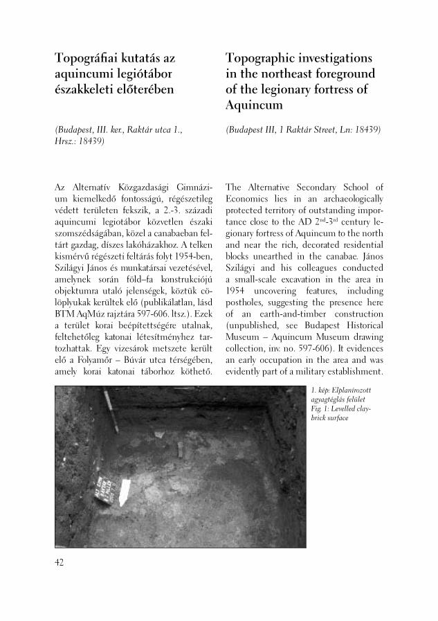
Az Alternatív Közgazdasági Gimnázi-um kiemelkedő fontosságú, régészetileg védett területen fekszik, a 2.-3. századi aquincumi legiotábor közvetlen északi szomszédságában, közel a canabaeban fel-tárt gazdag, díszes lakóházakhoz. A telken kismérvű régészeti feltárás folyt 1954-ben, Szilágyi János és munkatársai vezetésével, amelynek során föld–fa konstrukciójú objektumra utaló jelenségek, köztük cö-löplyukak kerültek elő (publikálatlan, lásd BTM AqMúz rajztára 597-606. ltsz.). Ezek a terület korai beépítettségére utalnak, feltehetőleg katonai létesítményhez tar-tozhattak. Egy vizesárok metszete került elő a Folyamőr – Búvár utca térségében, amely korai katonai táborhoz köthető.
Topográfi ai kutatás az aquincumi legiótábor északkeleti előterében
(Budapest, III. ker., Raktár utca 1., Hrsz.: 18439)
42
Topographic investigations in the northeast foreground of the legionary fortress of Aquincum
(Budapest III, 1 Raktár Street, Ln: 18439)
The Alternative Secondary School of Economics lies in an archaeologically protected territory of outstanding impor-tance close to the AD 2nd-3rd century le-gionary fortress of Aquincum to the north and near the rich, decorated residential blocks unearthed in the canabae. János Szilágyi and his colleagues conducted a small-scale excavation in the area in 1954 uncovering features, including postholes, suggesting the presence here of an earth-and-timber construction (unpublished, see Budapest Historical Museum – Aquincum Museum drawing collection, inv. no. 597-606). It evidences an early occupation in the area and was evidently part of a military establishment.
1. kép: Elplanírozott agyagtéglás felületFig. 1: Levelled clay-brick surface
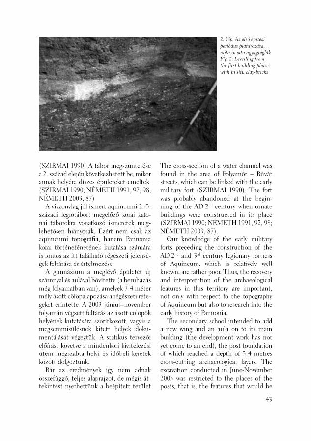
2. kép: Az első építési periódus planírozása, rajta in situ agyagtéglákFig. 2: Levelling from the fi rst building phase with in situ clay-bricks
(SZIRMAI 1990) A tábor megszüntetése a 2. század elején következhetett be, mikor annak helyére díszes épületeket emeltek. (SZIRMAI 1990; NÉMETH 1991, 92, 98; NÉMETH 2003, 87) A viszonylag jól ismert aquincumi 2.-3. századi legiótábort megelőző korai kato-nai táborokra vonatkozó ismeretek meg-lehetősen hiányosak. Ezért nem csak az aquincumi topográfi a, hanem Pannonia korai történeténetének kutatása számára is fontos az itt található régészeti jelensé-gek feltárása és értelmezése. A gimnázium a meglévő épületét új szárnnyal és aulával bővítette (a beruházás még folyamatban van), amelyek 3-4 méter mély ásott cölöpalapozása a régészeti réte-geket érintette. A 2003 június–november folyamán végzett feltárás az ásott cölöpök helyének kutatására szorítkozott, vagyis a megsemmisülésnek kitett helyek doku-mentálását végeztük. A statikus tervezői előírást követve a mindenkori kivitelezési ütem megszabta helyi és időbeli keretek között dolgoztunk. Bár az eredmények így nem adnak összefüggő, teljes alaprajzot, de mégis át-tekintést nyerhettünk a beépített terület
The cross-section of a water channel was found in the area of Folyamőr – Búvár streets, which can be linked with the early military fort (SZIRMAI 1990). The fort was probably abandoned at the begin-ning of the AD 2nd century when ornate buildings were constructed in its place (SZIRMAI 1990; NÉMETH 1991, 92, 98; NÉMETH 2003, 87). Our knowledge of the early military forts preceding the construction of the AD 2nd and 3rd century legionary fortress of Aquincum, which is relatively well known, are rather poor. Thus, the recovery and interpretation of the archaeological features in this territory are important, not only with respect to the topography of Aquincum but also to research into the early history of Pannonia. The secondary school intended to add a new wing and an aula on to its main building (the development work has not yet come to an end), the post foundation of which reached a depth of 3-4 metres cross-cutting archaeological layers. The excavation conducted in June-November 2003 was restricted to the places of the posts, that is, the features that would be
43

3. kép: Kiszedett falak a metszetben az építmény planírozásávalFig 3: Traces of removed walls together with the construction levelling in the profi le
egészére, ami segítheti a környéken koráb-ban feltárt jelenségek értelmezését is.
A főbb topográfi ai eredmények 1. A terület nyugati részén, a Szent-endrei út mentén felépülő szárny alatt a legalsó rétegekben két építési periódust lehetett megfi gyelni. Mindkettőben agyagtéglákból építkeztek, majd a lebon-tott épületeket elplanírozták. (1-2. kép) Az általunk kutatott terület északi vé-gében kétperiódusú paliszádfal mutat-kozott. (3-4. kép) A két építkezés között több ponton is árvízre utaló homokréteget dokumentáltunk. Az épületek elplaníro-zása fölött vastag – római kori – feltöltés mutatkozott, amelyen kőfal, terrazzópadló és kisebb kemencék, tüzelőhelyek marad-ványait lehetett észlelni. A legkésőbbi peri-
44
destroyed were documented. Following the specifi cations of the architectural design, we worked within the chronologi-cal and spatial frames determined by the current pace of construction. Although the results will not produce a coherent, complex ground plan, we can gain an overall picture of the territory of the building as a whole, which can help with the interpretation of the features formerly unearthed in the region.
Main topographic results 1. Two periods of construction could be observed in the lowermost layers under the area o f the wing to be constructed along Szentendrei Road in the western part of the territory. Clay bricks were used in both periods following which the demolished buildings were levelled (Figs. 1-2). A pali-sade wall of two periods was uncovered in the eastern end of the investigated terri-tory (Figs. 3-4). Between the two construc-tions we could document sand layers from fl ooding at several places. A thick fi ll from the Roman period lay over the levelled buildings, on top of which the remains of a stone wall, a terrazzo fl oor and small ovens and kilns could be observed. The latest period was destroyed by the graves from a cemetery from the 18th-19th centuries. 2. In the former gymnasium of the school in the eastern part of the same wing, the fragments of pavements, perhaps road layers, the levelling of the above-mentioned clay brick period and a thick fi ll from the Roman period were observed. A corner pillar from a graveyard could be associated to the latest Roman period. 3. Disturbed Roman brick graves and a grave constructed of stones could be ob-served south and east of the above areas,

4. kép: Gerendanyomok, a metszetben az építmény planírozásávalFig. 4: Traces of timbers together with the construction levelling in the profi le
ódust a 18-19. században létesült temető sírjai semmisítették meg. 2. Ugyanezen épületszárny keleti felé-ben, az iskola korábbi tornatermében lekövezés – esetleg útrétegek – részleteit, továbbá az említett agyagtéglás periódus planírozását, majd vastag római kori fel-töltést fi gyelhettünk meg. A legkésőbbi római időszakhoz sorolható volt egy sír-kerthez tartozó sarokpillér. 3. Az iskola jelenlegi udvarának terü-letén, az eddigiektől délre illetve keletre, az új aula területén, kirabolt római tég-lasírokat és egy kövekből összeállított sírt lehetett megfi gyelni. Itt épített síremlé-kekhez tartozó faragványokat (oszloptörzs darabja) és egy feliratos sztélé töredékét találtuk, másodlagos felhasználásban. A sírok kirablása és az általában megfi gyelhe-tő bolygatás valószínűleg az újkori temető létesítése, illetve azt követően az iskola 19. század végi építése során történhetett. A terület beépítésére a Kr. u. 1. század 2. felében került sor. Ebben az időben egy segédcsapat tábora állhatott itt, amelyet auxiliáris vicus vett körül. Pillanatnyilag nem dönthető el egyértelműen, hogy az agyagtéglás építmény a castellumhoz vagy a vicushoz tartozott-e.
in the territory of the present school yard, in the area of the future aula. We found carvings (a fragment from a column shaft) and a fragment of an inscribed ste-le, which had been secondarily used and had belonged to the recovered funerary monument. The robbing of the graves and the disturbances observable everywhere can perhaps be dated from the establish-ment of the modern cemetery and the subsequent construction of the school building at the end of the 19th century. The territory was built in the second half of the AD 1st century. An auxiliary fort may have stood here surrounded by the vicus. As yet it cannot be decided for certain whether the clay brick construc-tion belonged to the castellum or the vicus. The early fort and its vicus were desert-ed at the beginning of the AD 2nd century, probably when the seat of the governor was transferred here. After the construc-tion of the AD 2nd-3rd century legionary fortress, the territory was loosely built-up with respect to the proximity of the fort to the south and the luxurious residential houses in the northern zone of the cana-bae in the north, built when the governor-
45

A Kr. u. 2. század elején – feltehetőleg a helytartói székhely idehelyezésekor - meg-szüntették a korai tábort és vicusát. A 2.-3. századi legiótábor felépülése után ez a terület csak gyéren lehetett beépítve, te-kintettel a tábor közelségére dél felől, és a helytartóság létesítésével a canabae északi sávjában felépült fényűző lakóházakra észak felől. Ehhez a hosszabb időszakhoz köthető néhány kőfal, terrazzópadló ma-radvány és kemence, amelyek részletesebb időrendi besorolása a leletanyag feldolgo-zása során lesz lehetséges. A Kr. u. 4. század első felében a későró-mai erőd megépítésével ezen a területen temető létesült, ahol a síroknál korábbi síremlékek darabjait is felhasználták. A munkálatok meglehetősen elhúzód-tak, a kivitelezésben mutatkozó nehézsé-gek miatt. A múzeum ehhez az ütemhez, a bevezetőben említett statikai előírások miatt kénytelen volt alkalmazkodni.
Németh Margit
46
Irodalom/References:
NÉMETH 1991 – Németh M.: Aquincum. Feltárások az 1981–1988 közötti időszak-ban. (Erschließungen in den Jahren 1981–1988.) BudRég 28 (1991) 91–105.SZIRMAI 1900 – Szirmai K.: Zur Chrono-logie der Auxiliarkastelle und des Legions-lagers des 2.-3. Jh. in Aquincum. In: Akten des 14. Internationalen Limeskongresses 1986. (Hrsg. Kandler, M. – Vetters, H.) RLiÖ 36/2, Wien, 1990, 683–688.NÉMETH 2003 – Németh M.: Die Mi-litäranlagen von Óbuda. In: Forschungen in Aquincum 1969–2002. (Red. P. Zsidi) Aquincum Nostrum II.2. Budapest, 2003, 87.
ship was established. A few stone walls, the remains of the terrazzo fl oor and the oven can be linked to this longer period. These can be dated more exactly only after the fi nd material has been analysed. A cemetery was established in the fi rst half of the AD 4th century at the time of the construction of the late Roman fort, where the remains of earlier funeral monuments were also used. The investigations were rather protract-ed because of diffi culties arising in the construction work. The museum had to respect this rate of progress because of the architectural specifi cations mentioned in the introduction.
Margit Németh
A Szentendrei út és a Bogdáni út sar-kán lévő benzinkút, illetve a Bogdáni úti buszpályaudvar közötti beépítetlen részen, az egykori HÉV megálló, majd TÜZÉP telep területén a BAUMAX cég már korábban barkácsáruház építését határozta el. Minthogy a szóban forgó terület az aquaeductus és a canabae északi temetője közé eső részen fekszik, régészeti szempontból különösen nagy érdeklődésre tartott számot. 1997-ben szondázó jellegű feltárás történt, (ZSIDI 1998, 65–71) amelyet az építési terv meg-változása, a lemezes házalap mélyebbre helyezése miatt 1999-ben és 2000-ben a leendő áruház csaknem teljes területére kiterjedően megelőző feltárás követett. (ZSIDI 2000, 62–75; ZSIDI 2001, 59–67) (1. kép) A korábbi ásatások kutatatlanul hagytak egy hozzávetőleg 80 m hosszú, és változó, 17–20 méter széles sávot a Rádl-ároktól délre és keletre, részben a beruházó építési szándékának megingása miatt, részben pedig azért, mert az említett terület tel-jes egészében a hajdani HÉV megállóhoz tartozó újkori feltöltésnek tűnt. Három év elteltével a beruházó mégis az építkezés megkezdése mellett döntött, ily módon az Aquincumi Múzeum számára is lehetőség nyílott a még érintetlen sáv átkutatására, amelyről közben kiderült, hogy csak el-
Kora római védmű és késő avar kori telep kutatása a canabae északi előterében
(Budapest, III. ker., Filatorigát, Hrsz.: 19244)
The BAUMAX fi rm decided to construct a DIY store in the territory of the former HÉV station, and later TÜZÉP site, in the vacant area between the petrol station on the corner of Szentendrei Road and Bogdáni Road and the bus station on Bog-dáni Road. As this area lies between the aquaeductus and the northern cemetery of the canabae, it seemed to be especially promising from an archaeological aspect. In 1997, a test excavation was conducted in the territory (ZSIDI 1998, 65–71). In 1999 and 2000, the excavations preceding the construction encompassed nearly the entire territory of the future store because changes had been made in the construc-tion plans and the laminated house foun-dation would be sunk deeper than had been planned previously (ZSIDI 2000, 62–75; ZSIDI 2001, 59–67). (Fig. 1) The former excavations left unex-plored an approximately 80 m long and a, more-or-less, 17–20 m wide zone south and east of the Rádl trench, because the construction intentions of the investors vacilated and the territory seemed to be a modern fi ll connected with the former HÉV station. After three years, the inves-tor decided to start the construction work after all, so an opportunity for the Aquin-cum Museum to investigate the intact zone presented itself. In the meantime,
Investigations of early Roman defence works and a Late Avar settlement in the northern outskirts of the canabae
(Budapest III, Filatorigát, Ln: 19244)
47
48
1. kép: Az ásatások helyszínrajza (1999–2003)Fig. 1: Ground plan of the excavations (1999–2003)
Őskori objektumokPrehistoric featuresKora római kori objektumokEarly Roman period features2.-3. századi kőcsatorna2nd-3rd century stone channel2.-3. századi kőépület2nd-3rd century stone buildingRómai kori sírokRoman gravesTéglás-freskós omladékBrick-fresco heapsAvar kori objektumokAvar features18. századi kőépület18th century stone buildingÚjkori beásásModern disturbance2003. évi ásatási területExcavations in 2003

enyésző mértékben bolygatták meg újabb kori feltöltéssel. Céljaink között szerepelt a már korábbi ásatások során részleteiben feltárt kora ró-mai védműrendszer további szakaszainak feltárása, valamint a részben már ugyan-csak ismert, 2.-3. századi kőépületből ki induló vízelvezető csatorna nyomvona-lának a tisztázása. Számítottunk továbbá, a korábbi tapasztalatok alapján, őskori objektumok (földbemélyített házak, különböző funkciójú gödrök), valamint népvándorlás kori gödörházak előkerü-lésére. Az ásatás első napján tudatták velünk, hogy az új építési terv értelmében a házalapot nyugat felé, a buszpályaudvar irányába kiszélesítik mintegy 4 méterrel. Ezért ezt a sávot is ugyanúgy 80 méter hosszúságban át kellett vizsgálnunk. A Bogdáni úti római temető közelsége miatt számoltunk annak lehetőségével, hogy ebben a nyugati sávban esetleg megfog-hatóvá válik a temető széle. Az elvárásoknak megfelelően ásatásunk során őskori, római kori és népvándorlás kori objektumokra bukkantunk, amelyek a középső sávban érdekes topográfi ai el-helyezkedést mutattak. A legkorábbi, késő bronzkori objektumok a földsáv északi végében, egy természetes, homokos ki emelkedésen kerültek elő az egykor Rádl-ároknak nevezett patak közelében. A földsáv közepén laza beépítettségű késő avar településrészletet tártunk fel. A déli részen sorakoztak a római kori objektu-mok, kivéve az említett kőcsatornát, amely nagyjából megfelezte az ásatási területet. A nyugati sáv északi részén ebből a rend-szerből hiányoztak az őskori objektumok. A két helyszínen összesen 66 objek-tumot tártunk föl, ebből mindössze 3 bizonyult újkori beásásnak. A legkorábbi időszakot, a késő bronzkort (urnamezős
this area turned out to have been only slightly disturbed by modern fi ll. Our purpose were to unearth more sec-tions of the early Roman defence works, details of which had already been uncov-ered, and to clarify the path of the water channel that began in a stone building dated to the AD 2nd-3rd centuries, details of which were also known. Based on previ-ous experience, the appearance of prehis-toric features (semi-subterranean houses, pits of diverse functions) and pit houses from the Migration Period could be ex-pected. We were informed the fi rst day of the excavation that the foundation of the building would be enlarged by 4 m in the direction of the bus station according to the new construction plan. So, we also had to check this zone along a length of 80 m. As the Roman cemetery of Bogdáni Road lay in the vicinity, we also had to count on the possibility of picking the edge of the cemetery in this western zone. As we had expected, prehistoric, Ro-man period and Migration period fea-tures were brought to light during the excavation. These features displayed an interesting topographic distribution in the central zone. The earliest, Late Bronze Age features were uncovered in the northern part of the zone on a natural, sandy elevation, near the stream, formerly called the Rádl ditch. Part of a loosely structured Late Avar settlement was unearthed in the centre of the zone. The features from the Roman period were situated in the southern part of the exca-vation except for the afore-mentioned stone channel, which approximately cut the excavation territory in half. Prehis-toric features were missing from this ter-ritorial distribution in the northern part of the western zone.
49
2. kép: A kora római erőd déli védműrendszere dél felőlFig. 2: The fortifi cation of the early Roman fortress from the south
kultúra) jó néhány kis méretű, elliptikus alakú gödrön kívül földbemélyített házak képviselték. (Az őskori emlékek konzu-lense Szilas Gábor volt.) Utóbbiakat a gödörházak számára előnyős, jó vízelve-zető képességű, homokos altalajba ásták le. Hozzájuk kapcsolható cölöplyukakat egyáltalán nem találtunk, így egykori felépítményük rekonstruálásához nem rendelkezünk megfelelő információval. A házakban nem észleltük tüzelőhely maradványát, vagy átégett foltként meg-maradt nyomát. Valószínűleg a lelőhely őskori fázisá-hoz tartozott az a baloldalára fektetett, kelet–nyugati tájolású csontváz is, amely a buszpályaudvar melletti sáv déli részén került elő. Sajnálatos, hogy deréktól lefelé eső részének a leendő áruház rézsűfala alatt kellett maradnia. A sír feltárható részéből lelet nem került elő. A kora római katonai objektum véd-művei és bizonyos járószint alatti konst-rukciós elemei már a korábbi ásatások során előkerültek. (ZSIDI 1998, 69–71; ZSIDI 2000, 67–70; ZSIDI 2001, 60–62)
50
Altogether 66 features were found at two sites. Only three of these proved to be modern pits. The earliest period, the Late Bronze Age (Urnfi eld culture) was represented by a number of small, ellip-tical pits and semi-subterranean houses. (Gábor Szilas supervised the excavation of the prehistoric remains.) The latter features were dug into the sandy ground, which offers favourable conditions for semi-subterranean houses with its excel-lent drainage properties. Ee could not fi nd postholes linked with them, so there is no information to help in reconstructing the superstructures. We did not observe remains of ovens or burnt discolourations suggesting fi ring places. The east–west oriented skeleton laying on its left side probably belonged to the prehistoric phase of the site. It was found in the southern part of the zone next to the bus station. Regrettably, the skeleton had to be left from the waist down under the bevelled wall of the future store. The unearthed part of the grave did not con-tain fi nds.

Adataink szűkösek a tábor egykori beépí-tettségére vonatkozóan, részben a termé-szetes erózió, részben a későbbi kultúrák romboló hatása miatt. Nem meglepő, hogy idei ásatásunk eredményei sem tud-tak a beépítettség vonatkozásában újabb információt nyújtani. Új adat viszont, hogy feltártuk az erőd déli vizesárkának egy szakaszát, amelynek északi oldalán egy vele párhuzamos, keskeny árkocska, az egykori paliszádárok futott. (2. kép) Utóbbi betöltéséből hatalmas mennyisé-gű, korai (1. század végi – 2. század eleji) anyag került elő. A vizesárok betöltésének rétegeit Horváth Zoltán geológus vizsgál-ta meg, aki megállapította, hogy az árok feltöltődése természetes úton indult meg, majd egy későbbi időpontban erőteljes emberi beavatkozással folytatódott. A természetes üledékképződés arra utal, hogy egy bizonyos időszakban, vélhetően a Rádl-árok hozamából, tartósan, nagy-jából egyenletes vízmennyiség áramlott a vizesárokba. Későbbi, tudatos megszűnte-tését a mesterséges betöltés bizonyítja. A korábbi ásatási eredmények is arra utalnak, hogy a katonai objektum megszűntetése előtt védműve legalább egyszer átalakult, feltöltött árka helyén cölöpköteg sorokból álló konstrukció épült. (ZSIDI 2000, 68) Az idei ásatáson két alkalommal, de már a korábbiak során is többször kerültek elő a vizesárok betöltéséből ha barcsos, téglás, freskódarabos törmelékkupacok, amelyek az említett, második periódushoz tartozó cölöpkötegek helyén tátongó mélyedé-seket töltötték ki. Az efféle kupacokból időnként értékes leletek kerültek elő, mint amilyen például az az amfora-nyak, amelyen egy pirossal festett, kurzív felirat töredéke olvasható. A vizesárok feltöltésében a cölöpköte-geknek szánt gödrök mellett voltak olyan
The defence works of the early Roman military feature and certain elements beneath the fl oor level had already been uncovered during previous excavation sea-sons (ZSIDI 1998, 69–71; ZSIDI 2000, 67–70; ZSIDI 2001, 60–62). We have only scarce data on the inner system of the camp area partly because of natural erosion processes and partly due to the destructive effects of later cultural oc-cupations. It is not astonishing that the results of the actual excavation could not furnish new information in this respect. A new achievement was the recovery of a stretch of the southern moat of the fort, on the northern side of which a narrow ditch, the one-time palisade ditch, ran in parallel to it (Fig. 2). The fi ll of the lat-ter yielded a huge number of early fi nds (end of the 1st century – beginning of the 2nd century). Zoltán Horváth, a geologist, studied the layers of the moat’s fi ll. He de-termined that the trench was fi rst fi lled in naturally, a process later intensifi ed by hu-man intervention. The natural deposition suggests that at one time, a steady amount water fl owed into moat, probably from the Rádl ditch. The artifi cial fi ll attests to the later, conscious termination of this moat. Former excavation results also provide evidence that before the abandonment of the military feature, the defence works were modifi ed at least once and a con-struction of rows of bundles of posts was built over the place of the fi lled-in moat (ZSIDI 2000, 68). The fi ll of the moat yielded debris, heaps of mortar, bricks and fresco fragments twice this year and sev-eral times in former seasons. They served to fi ll in the depressions that opened in the place of the bundles of posts from the above-mentioned second period. These heaps sometimes contained valuable fi nds
51
3. kép: Flavius (a-b) és Antoninus (c-d) kori bronz érmekFig. 3: Flavian (a-b) and Antoninian (c-d)period bronze coins
a b
c d
ovális alakú, nagy méretű beásások, ame-lyek betöltésében ugyanazt a fekete, isza-polt agyagot találtuk meg, amelyet ezen a területen az építkezéseket megelőző tereprendezés során alkalmaztak a róma-iak a lazább talaj tömörítésére. Ugyanez fi gyelhető meg például a 2.-3. századi kőépület közvetlen környezetében is. (ZSIDI 2001, 63) A tömörítőanyag a tá-bor második építési periódusával hozható összefüggésbe. A tábor különös jelentőséggel bírha-tott Domitianus germánok ellen viselt háborúja idején. Feladása, tudatos döntés eredménye volt, amely bizonyosan össze-függött a háború lezárásával, valamint Traianus új határvédelmi koncepciójának kivitelezésével. A tábor lebontása az érem-leletek alapján (3. kép) is Traianus korára tehető. Tisztáztuk a 2.-3. századi kőépület csa-tornájának nyomvonalát. A földberakott, habarcs nélkül készített kőcsatorna futása ívelten haladt. A kőépületből északnyugati irányba indult, majd a most feltárt részen nyugat felé hajlott el, hogy aztán egy újabb ívvel megint északnyugatnak forduljon.
52
like the amphora neck on which the frag-ment of a cursive inscription painted in red can be read. Beside the pits dug for the post bundles there were large, oval pits dug into the fi ll of the moat, which were fi lled in with black, levigated clay that the Romans used to landscape by packing down the loose soil before construction work. The same could be observed, for example, in the area of the stone building from the 2nd-3rd centuries (ZSIDI 2001, 63). The packing material can be associated with the sec-ond construction period of the fort. The fort must have had a particular im-portance during Domitian’s war against the Germans. Its abandonment was the result of a conscious decision, which was certainly connected with the termination of the war and the execution of Trajan’s new border defence concept. The coin fi nds also date the demolition of the fort to Trajan’s period. (Fig. 3) The path of the channel coming from the 2nd-3rd century stone building was clarifi ed. The stone channel, running in an arc, was dug into the earth without use of

(4. kép) Az újonnan feltárt részen a csa-torna keresztmetszete viszonylag szűk volt, lelet belőle nem került elő. A korábbi ásatások során feltárt északnyugati szakasz annyival szélesebb volt, hogy ott a csatorna eredeti funkciójának elvesztése után még betemetkezést is regisztrálni lehetett. A nagyobb keresztmetszet magasabb vízho-zamot feltételez, vagyis gyanítható, hogy az eredeti csatornába több mellékág is bekapcsolódott. Ilyen lehetett az a fenteb-bivel konstrukciójában teljesen megegyező csatorna, amelyet a nyugati sáv rézsűfalá-ban fedeztünk fel. Ez utóbbi valamelyest magasabban helyezkedett el a kőépület csatornájánál, de mivel csak metszetben volt megfogható, sem a pontos irányát, sem a lejtését nem lehetett megállapítani. Ráadásul a Filatorigát építését megelőző tereprendezés során erősen megrongá-lódott, beomlott. (Közvetlenül az újkori feltöltés alatt jelentkezett). A későbbiek során, az áruház nyugati támfalának alap-árkában talán még lesz mód felületben is megvizsgálni az említett kőcsatornát. A nyugati sávban nem sikerült elérni a Bogdáni úti temető keleti szegélyét, de
4. kép: 2.-3. századi kőépülethez tartozó
csatorna újonnan feltárt szakasza
Fig. 4: Part of the recently excavated
channel of a 2nd-3rd century building
mortar. It began in a northwesterly direc-tion from the stone building, then curved westwards in the area unearthed this year only to turn again to the northwest with another curve (Fig. 4). The cross-section of the channel was rather narrow in the recently unearthed area and it did not yield any fi nds. The formerly unearthed northwestern stretch of the channel was so much wider that it could even hold a burial after it had lost its original func-tion. The larger cross-section supposes a larger water output, which implies that some side channels joined the original channel. The channel uncovered in the bevelled wall of the western zone, which had an identical construction, may have been such a side channel. It lay somewhat higher than the channel of the stone building. Regrettably, it could only be observed in the section wall so we could not determine either its direction or its slope. To make matters worse, it was badly damaged and collapsed during landscap-ing work preceding the construction of the Filatorigát. (It appeared just below the modern fi ll.) Perhaps we will have an op-
53
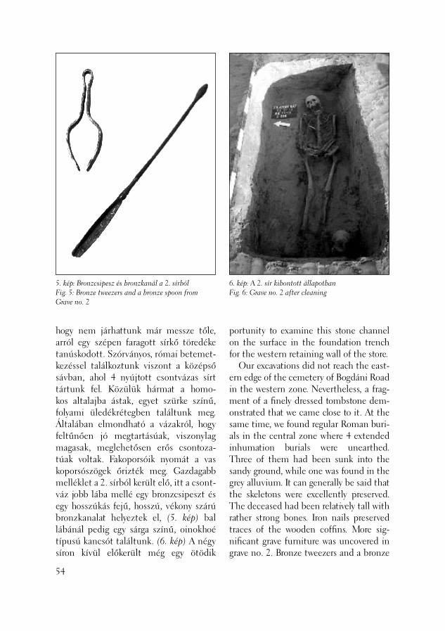
6. kép: A 2. sír kibontott állapotbanFig. 6: Grave no. 2 after cleaning
5. kép: Bronzcsipesz és bronzkanál a 2. sírbólFig. 5: Bronze tweezers and a bronze spoon from Grave no. 2
hogy nem járhattunk már messze tőle, arról egy szépen faragott sírkő töredéke tanúskodott. Szórványos, római betemet-kezéssel találkoztunk viszont a középső sávban, ahol 4 nyújtott csontvázas sírt tártunk fel. Közülük hármat a homo-kos altalajba ástak, egyet szürke színű, folyami üledékrétegben találtunk meg. Általában elmondható a vázakról, hogy feltűnően jó megtartásúak, viszonylag magasak, meglehetősen erős csontoza-túak voltak. Fakoporsóik nyomát a vas koporsószögek őrizték meg. Gazdagabb melléklet a 2. sírból került elő, itt a csont-váz jobb lába mellé egy bronzcsipeszt és egy hosszúkás fejű, hosszú, vékony szárú bronzkanalat helyeztek el, (5. kép) bal lábánál pedig egy sárga színű, oinokhoé típusú kancsót találtunk. (6. kép) A négy síron kívül előkerült még egy ötödik
54
portunity to examine this stone channel on the surface in the foundation trench for the western retaining wall of the store. Our excavations did not reach the east-ern edge of the cemetery of Bogdáni Road in the western zone. Nevertheless, a frag-ment of a fi nely dressed tombstone dem-onstrated that we came close to it. At the same time, we found regular Roman buri-als in the central zone where 4 extended inhumation burials were unearthed. Three of them had been sunk into the sandy ground, while one was found in the grey alluvium. It can generally be said that the skeletons were excellently preserved. The deceased had been relatively tall with rather strong bones. Iron nails preserved traces of the wooden coffi ns. More sig-nifi cant grave furniture was uncovered in grave no. 2. Bronze tweezers and a bronze

7. kép: Szabálytalan betemetkezés a vizesárok feltöltésébenFig. 7: Irregular inhumation in the fi ll of the moat
csontváz is az egyik nagy méretű beásás bontásakor. Természetellenes testhely-zete arra utalt, hogy általunk ismeretlen okból (gyilkosság áldozata, vagy a társa-dalomból kivetett személy lehetett) nem részesítették tisztességes temetésben, egyszerűen háttal belökték egy, az egy-kori vizesárok betöltésébe ásott gödörbe. A csontváz mellett, de szokatlan helyen és szokatlanul távol tőle egy Traianus-kori bronzpénzt találtunk. Sírobulusz szerepe kétséges. (7. kép) A 7.-8. századi késő avar kori település eddig feltárt részét további földbemé-lyített házakkal egészítettük ki. Közös ismertetőjegyük, hogy egykori lakóik az északi, keleti vagy északkeleti sarokban tüzelőhelyet építettek. Ezek tört kőből, továbbá a sokat emlegetett kőépület ma-radványából könnyen beszerezhető római tegula-, és imbrex-töredékekből, valamint rózsaszínű habarcsból készültek. Az itt feltárt avar házak másik közös vonása, hogy egészen a homokos altalajig leásták őket, ezért külön padlókiképzéssel nem találkozunk. Falaik enyhén rézsűs kialakí-tásúak. Mivel a középső sávban nem volt módunk az egyes objektumokat a jelent-kezési szinttől kezdődően feltárni, csak azokat a cölöplyukakat regisztrálhattuk, amelyek elérték a mi induló szintünket. A cölöprendszerek bizonytalansága mi-att a felépítmények rekonstrukciója is nehézségekbe ütközik. A nyugati sávban szerencsésebbek voltunk, itt az egyes objektumokat a jelentkezési szintjüktől tudtuk vizsgálni. Teljes egészében si-került feltárnunk egy avar lakóházat, ha-talmas kemencéje az északi sarokban állt. A két rövid oldal közepén egy-egy nagy átmérőjű cölöplyukat találtunk, amelyek alapján a legszokványosabb, nyeregtetős felépítményt lehet rekonstruálni. A ház
spoon with an elongated bowl (Fig. 5) and a long and thin handle were placed beside the right foot of the deceased and a yel-low oinokhoé type jug was found by the left foot (Fig. 6). Beside the four graves, a fi fth skeleton was also discovered during the cleaning of a large pit. The “twisted” posture suggests that, for some unknown reason (a murder victim or an outcast), the individual did not receive a normal burial but was simply pushed on the back forward into a pit dug into the fi ll of the former moat. We found a bronze coin from Trajan’s period beside the skeleton although in an unusual place and unusu-ally far from it. Its role as a funeral obulus is questionable (Fig. 7). The unearthed part of the late Avar set-tlement from the 7th-8th centuries could be enlarged with some more semi-sub-
55
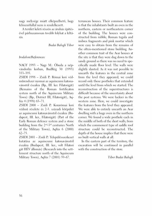
nagy mélysége miatt elképzelhető, hogy felmenőfallal nem is rendelkezett. A terület keleti részén az áruház építés-ével párhuzamosan tovább folyhat a feltá-rás.
Budai Balogh Tibor
56
Irodalom/References:
NAGY 1993 – Nagy M.: Óbuda a nép-vándorlás korban, BudRég 30 (1993) 353–395.ZSIDI 1998 – Zsidi P.: Római kori véd-műrendszer nyomai az aquincumi katona-várostól északra (Bp., III. ker. Filatorigát) (Remains of the Roman fortifi caton system north of the Aquincum Military Town) (Bp., District III, Filatorigát), Aq-füz 4 (1998) 65–71.ZSIDI 2000 – Zsidi P.: Korarómai kori védmű részlete és 2-3. századi kőépület az aquincumi katonavárostól északra (Bu-dapest, III. ker., Filatorigát) (Part of the Early Roman defence system and a stone building from the 2nd-3rd centuries North of the Military Town), Aqfüz 6 (2000) 62–75.ZSIDI 2001 – Zsidi P.: Településszerkezet kutatása az aquincumi katonavárostól északra (Budapest, III. ker., volt Filatori gát HÉV állomás) (Research into the sett-lement structure north of the Aquin cum Military Town), Aqfüz 7 (2001) 59–67.
terranean houses. Their common feature is that the inhabitants built an oven in the northern, eastern or northeastern corner of the building. The houses were con-structed from rubble, Roman tegula and imbrex fragments and pink mortar which were easy to obtain from the remains of the often-mentioned stone building. An-other common trait of the Avar houses at the site is that they were dug down to the sandy ground so there was no need to spe-cifi cally made fl oor level. The walls were slightly slanted. As it was not possible to unearth the features in the central zone from the level they appeared, we could record only those postholes that extended until the level from which we started. The reconstruction of the superstructures is diffi cult because of the uncertainty about the post systems. We were luckier in the western zone. Here, we could investigate the features from the level they appeared. We were able to entirely unearth an Avar dwelling with a huge oven in the northern corner. We found a wide posthole each in the middle of both of the short walls, from which the commonest type of saddle roof structure could be reconstructed. The depth of the house implies that there were no built vertical walls at all. In the eastern part of the territory, the excavation will be continued in parallel with the construction of the store.
Tibor Budai Balogh

A BTM Aquincumi Múzeuma 2003. jú-lius 9. és 28. között végezte el a terület szondázó jellegű régészeti feltárását. Az aquincumi polgárváros délnyugati szom-szédságában, régészetileg védett telken lakóparkot kívánnak építeni, amelynek alapjai – a beruházó által hitelesített tervek alapján – a mai szinttől 1,6 méter mélységig bolygatják a talajt. (1. kép) A területtől keletre Pető Mária 1977 és 1980 között több kutatóárokban az akkori felszíntől 80–100 centiméter mélyen ró-mai kultúrréteget talált sok kerámiaanyag-gal, illetve néhány későrómai sírt. (PETŐ 1984, 275–290) Tovább haladva keletre, a városfaltól délre pedig legalább két római kori épület maradványát (fogadó jellegű épület?) és útrészleteket regisztrált. A feltárás eredményei alapján egyértelművé vált, hogy a polgárváros déli városfalán kívül is számolni kell beépítéssel, a lelet-anyag alapján elsősorban a Kr. u. 2. század végétől – 3. század elejétől. A feltárás során – már meglévő épü-letalapok miatt – csak két árok kialakí-tására volt mód: egy észak–déli (5×29 méter) „A” és egy kelet–nyugati irányú „B” (5×22,8 méter). A két felületben ugyanaz, az alább ismertetett rétegsor volt ta pasztalható. 1. A jelenlegi terepszint alatt körülbelül 80 centiméter vastag újkori feltöltés volt,
Római kori beépítettség kutatása az aquincumi polgárváros déli városfalán kívül
(Budapest, III. ker., Huszti út 21., Hrsz. 18910/109)
The Aquincum Museum of the Budapest Historical Museum conducted test exca-vations at the site between 9 and 28 July, 2003. The construction of a residential district is planned in an archaeologically protected lot on the southwest side of the Civil Town of Aquincum. The foun-dations will disturb the soil down to the depth of 1.6 m from the actual fl oor level according to the plans authorised by the investor (Fig. 1). Between 1977 and 1980, Mária Pető found a Roman culture bearing layer with many sherds and a few late Roman graves in a number of trenches extending down to a depth of 80–100 cm beneath the contemporary fl oor level (PETŐ 1984, 275–290). Farther to the east, she documented the remains of at least two buildings from the Roman period (inns?) and segments of a road. The results of the excavation suggested that houses could be expected outside the southern town wall of the Civil Town as well, especially from the end of the 2nd and the beginning of the 3rd centuries based on the fi nd mate-rial. The already existing foundations of buildings allowed us to open only two trenches: trench “A” running in a north–south direction (5×29 m) and trench “B” running in an east–west direction
Investigation of Roman period occupation outside the southern town wall of the Aquincum Civil Town
(Budapest III, 21 Huszti Road,Ln:18910/109)
57
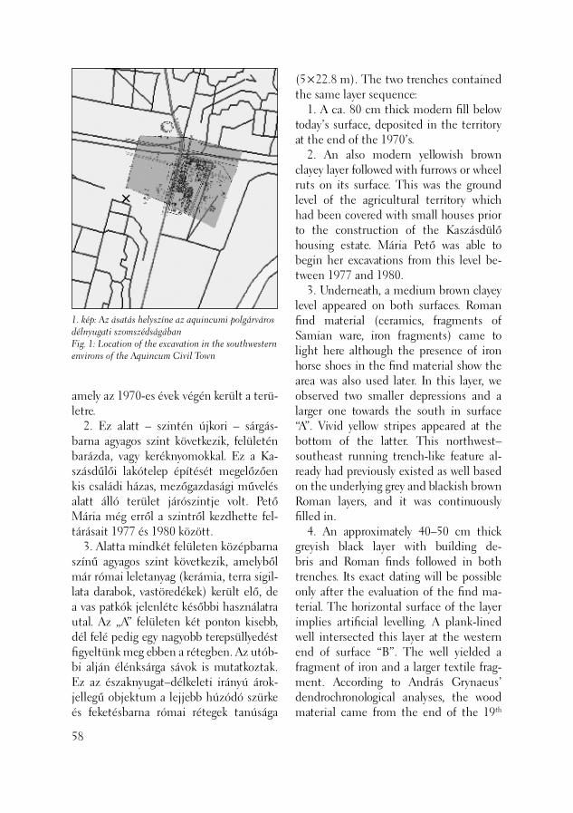
1. kép: Az ásatás helyszíne az aquincumi polgárváros délnyugati szomszédságábanFig. 1: Location of the excavation in the southwestern environs of the Aquincum Civil Town
amely az 1970-es évek végén került a terü-letre. 2. Ez alatt – szintén újkori – sárgás-barna agyagos szint következik, felületén barázda, vagy keréknyomokkal. Ez a Ka-szásdűlői lakótelep építését megelőzően kis családi házas, mezőgazdasági művelés alatt álló terület járószintje volt. Pető Mária még erről a szintről kezdhette fel-tárásait 1977 és 1980 között. 3. Alatta mindkét felületen középbarna színű agyagos szint következik, amelyből már római leletanyag (kerámia, terra sigil-lata darabok, vastöredékek) került elő, de a vas patkók jelenléte későbbi használatra utal. Az „A” felületen két ponton kisebb, dél felé pedig egy nagyobb terepsüllyedést fi gyeltünk meg ebben a rétegben. Az utób-bi alján élénksárga sávok is mutatkoztak. Ez az északnyugat–délkeleti irányú árok-jellegű objektum a lejjebb húzódó szürke és feketésbarna római rétegek tanúsága
58
(5×22.8 m). The two trenches contained the same layer sequence: 1. A ca. 80 cm thick modern fi ll below today’s surface, deposited in the territory at the end of the 1970’s. 2. An also modern yellowish brown clayey layer followed with furrows or wheel ruts on its surface. This was the ground level of the agricultural territory which had been covered with small houses prior to the construction of the Kaszásdülő housing estate. Mária Pető was able to begin her excavations from this level be-tween 1977 and 1980. 3. Underneath, a medium brown clayey level appeared on both surfaces. Roman fi nd material (ceramics, fragments of Samian ware, iron fragments) came to light here although the presence of iron horse shoes in the fi nd material show the area was also used later. In this layer, we observed two smaller depressions and a larger one towards the south in surface “A”. Vivid yellow stripes appeared at the bottom of the latter. This northwest–southeast running trench-like feature al-ready had previously existed as well based on the underlying grey and blackish brown Roman layers, and it was continuously fi lled in. 4. An approximately 40–50 cm thick greyish black layer with building de-bris and Roman fi nds followed in both trenches. Its exact dating will be possible only after the evaluation of the fi nd ma-terial. The horizontal surface of the layer implies artifi cial levelling. A plank-lined well intersected this layer at the western end of surface “B”. The well yielded a fragment of iron and a larger textile frag-ment. According to András Grynaeus’ dendrochronological analyses, the wood material came from the end of the 19th

szerint már korábban is létezett, betöltő-dése folyamatos lehetett. 4. Ezt követte a mindkét árokban közel 40–50 centiméter vastag, római leletanya-got tartalmazó szürkésfekete, épülettörme-lékes szint. Pontosabb korhatározása csak a leletanyag kiértékelése után lehetséges. A réteg vízszintes felszíne planírozásra utal. A „B” felületen, annak nyugati végénél ezt a réteget vágta egy deszkabéleletű kút, amelyből vastöredék és egy nagyobb textil-maradvány került elő. Faanyaga Grynaeus András dendrokronológiai elemzése alap-ján a 19. század végéről származik. A kút felső részét egy későbbi tereprendezéskor elpusztíthatták, ezért jelentkezett csak ebben a rétegben. (2. kép) 5. Ezen réteg alatt egy feketésbar-na, római kori réteg következett. A szintből – összefüggés és objektumok nélkül – nagy mennyiségű római kerá-miatöredék, építési törmelék, ember- és állatcsont darab, üvegtöredék került elő. A réteg tetején, az „A” felület déli és a „B” felület keleti végében többszörösen meg-újított, fehér, murvás járószint-részletek, épületomladék és egy vörös, sávos festésű freskótöredék, elplanírozott (esetleg ké-
century. Later landscaping must have de-stroyed the upper part of the well which is why it appeared only in this layer (Fig. 2). 5. A blackish brown layer from the Ro-man period lay beneath this layer. A large number of Roman pottery sherds, build-ing debris, human and animal bone frag-ments and glass fragments were recovered but lacked any patterning or associated features. On top of the layer were found segments of repeatedly renewed fl oor levels composed of white rubble, building debris and a red fresco fragment with painted band pattern. These indicate the levelled (perhaps later turned by the plough) ruins of a building in the southern part of sur-face “A” and at the eastern end of surface “B”. The presence of horseshoes in the layer, which seem to be later, may explain the destruction of the Roman features (agricultural cultivation). We observed traces of a pit in each of the same places. 6. Under this culture-bearing layer, a 10-15 cm thick clay layer followed, which was missing in the eastern and western ends of the unearthed territory. The natu-rally deposited clay layer contained no fi nds.
59
2. kép: 19. századi kút részleteFig. 2: Remains of a 19th century well
sőbb szétszántott) épületmaradványokra utal. A rétegből előkerült – és egyelőre későbbinek tűnő – patkók jelenléte magya-ráz hatja a római objektumok pusztulását (mezőgazdasági művelés). Ugyanitt két ponton egy-egy beásás nyomait is doku-mentáltuk. 6. Ez alatt a kultúrréteg alatt egy vékony, 10–15 centiméter vastag sárga agyagréteg következett, amely azonban a feltárt terü-let nyugati, illetve keleti végénél hiány-zott. A természetes eredetű agyagrétegből leletanyag már nem került elő. 7. A rétegsor alján masszív, rétegzett kavicságy bukkant elő, amelynek uralko-dóan dolomitanyagú összetétele, nyugati irányból, a hegyek felől érkező eróziós tevékenységre utal. A jelen feltárás előzetes eredményei tehát megerősítik a Pető Mária által meg-fi gyelteket. Az általunk feltárt rétegsor alapján valószínű, hogy a polgárváros nyugati részének déli városfalán kívül eső több tíz méter széles sávja nem csak kelet, hanem nyugat felé is beépített lehetett (a terra sigillata leletanyag előzetes vizsgálata alapján) elsősorban a Kr. u. 2. század má-sodik felétől. A későbbi korok mezőgazda-sági művelése és tereprendezései ugyan nagyrészt elpusztították a római felszínt, de az épületomladékok, járószintmarad-ványok és a nagyszámú leletanyag intenzív használatra utalnak.
T. Láng Orsolya
60
Irodalom/References:
PETŐ 1984 – Pető M.: Régészeti kutatá-sok a Kaszás-dűlő területén (Archäologi-sche Forschungen auf dem Gebeit der Ka-szás-dűlő). BudRég 25 (1984) 275–290.
7. A massive, stratifi ed bed of gravel appeared at the bottom of the layer se-quence. The mainly dolomite composi-tion implies erosional activity from the west, from the direction of the hills. The preliminary results of this excava-tion support Mária Pető’s conclusion. As the layer series we unearthed indicates the existence of a nearby building, it seems that buildings stood in the few dozen me-tre wide zone outside the southern town wall of the Civil Town not only in the east but also in the west These constructions mostly date from the second half of the AD 2nd century (based on a preliminary analysis of the Samian ware material). Ag-ricultural cultivation and landscaping in later periods mostly destroyed the Roman surface although the ruins of the build-ings, the remains of the fl oor levels and the large number of fi nds all bear witness to its former intensive use.
Orsolya T. Láng

A Szentendrei úti Auchan áruház épí-téséhez kapcsolódóan, a Záhony utcai csomópont fejlesztése, átalakítása (új bekanyarodó sáv kialakítása) miatt vált szükségessé a római vízvezeték egy szaka-szának újbóli feltárása. (1. kép) Az ásatást 2003. szeptember 29. – október 18. között a Varpex Rt. megbízásából végeztük el a Szentendrei út két útpályáját elválasztó füves sávban, a Záhony utca vonalától északra. A kijelölt 3,5 méter széles felület a vízvezeték 60-70. számú pillérei közti szakaszra esett, (Kaba Melinda számozása szerint, KABA 1976, 61. ábra) a római kori városfal vonalán kívül. A feltárás célja egyrészt a korábbi ása-tások hitelesítése, újbóli dokumentálása volt az új sáv alapozása által érintett mély-ségig, másrészt két, a vízvezeték marad-ványaihoz tartozó, és a sávval lefedendő területen elhelyezkedő kőtömb szakszerű kiemelését és új helyen történő műemléki bemutatását kellett előkészíteni. Az ásatás folyamán megfi gyelhető és elkülöníthető volt a korábbi bolygatások, ásatások több fázisa, érintetlen terület azonban alig mutatkozott. A pillérek kő-anyagának kitermelését célzó újkori be-ásásokat Foerk Ernő 1923-ban publikált kutatásai, (FOERK 1923) majd pedig Kaba Melinda 1975-ös ásatásai követték. (KABA 1976) A felületben kibontható
Feltárás a Szentendrei úti aquaeductus nyomvonalán
(Budapest, III. ker., Szentendrei út – Záhony utca kereszteződés)
A new stretch of the Roman aqueduct had to be unearthed because of the develop-ment and , modifi cations to the road junc-tion at Záhony Street (the construction of a new turn-off lane) linked with the con-struction of the Auchan supermarket on Szentrendrei Road (Fig. 1). The excavation was commissioned by the Varpex Rt. in the grassy divide between the two carriageways of Szentendrei Road, just north of Záhony Street, between September 29 and Oc-tober 18, 2003. The 3.5 m wide zone to be excavated included the area between pillars nos. 60 and 70 (based on Melinda Kaba’s numbering system, KABA 1976, fi g. 61) outside the Roman period town wall. The aim of the excavations was partly authentication of previous excavations and their re-documentation down to the depth needed for the foundation of the new lane, the appropriate lifting of a stone block from the aqueduct lying in the path of the new lane and its preparation for ex-hibition in another location. The individual phases of former distur-bances and excavations could be observed and differentiated during the excavation, and we could hardly fi nd surfaces which had not been previously impacted by former excavation work. The modern pits dug with the intention of quarrying stone material from the aqueduct pillars were
Excavation along the aqueduct on Szentendrei Road
(Budapest III, intersection of Szentendrei Road – Záhony Street)
61
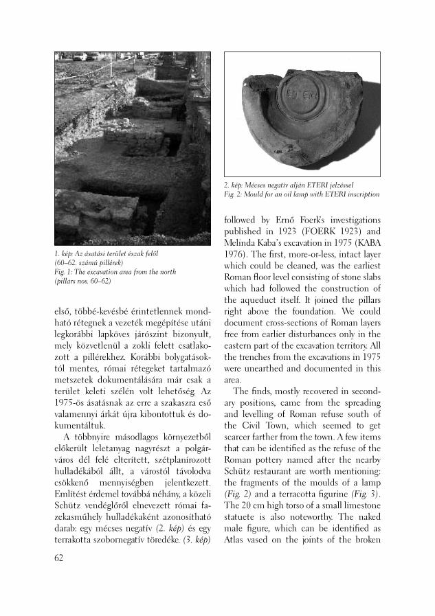
1. kép: Az ásatási terület észak felől (60–62. számú pillérek)Fig. 1: The excavation area from the north (pillars nos. 60–62)
2. kép: Mécses negatív alján ETERI jelzésselFig. 2: Mould for an oil lamp with ETERI inscription
első, többé-kevésbé érintetlennek mond-ható rétegnek a vezeték megépítése utáni legkorábbi lapköves járószint bizonyult, mely közvetlenül a zokli felett csatlako-zott a pillérekhez. Korábbi bolygatások-tól mentes, római rétegeket tartalmazó metszetek dokumentálására már csak a terület keleti szélén volt lehetőség. Az 1975-ös ásatásnak az erre a szakaszra eső valamennyi árkát újra kibontottuk és do-kumentáltuk. A többnyire másodlagos környezetből előkerült leletanyag nagyrészt a polgár-város dél felé elterített, szétplanírozott hulladékából állt, a várostól távolodva csökkenő mennyiségben jelentkezett. Említést érdemel továbbá néhány, a közeli Schütz vendéglőről elnevezett római fa-zekasműhely hulladékaként azonosítható darab: egy mécses negatív (2. kép) és egy terrakotta szobornegatív töredéke. (3. kép)
62
followed by Ernő Foerk’s investigations published in 1923 (FOERK 1923) and Melinda Kaba’s excavation in 1975 (KABA 1976). The fi rst, more-or-less, intact layer which could be cleaned, was the earliest Roman fl oor level consisting of stone slabs which had followed the construction of the aqueduct itself. It joined the pillars right above the foundation. We could document cross-sections of Roman layers free from earlier disturbances only in the eastern part of the excavation territory. All the trenches from the excavations in 1975 were unearthed and documented in this area. The fi nds, mostly recovered in second-ary positions, came from the spreading and levelling of Roman refuse south of the Civil Town, which seemed to get scarcer farther from the town. A few items that can be identifi ed as the refuse of the Roman pottery named after the nearby Schütz restaurant are worth mentioning: the fragments of the moulds of a lamp (Fig. 2) and a terracotta fi gurine (Fig. 3). The 20 cm high torso of a small limestone statuete is also noteworthy. The naked male fi gure, which can be identifi ed as Atlas vased on the joints of the broken
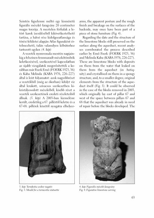
Szintén fi gyelemre méltó egy kisméretű fi gurális mészkő faragvány 20 centiméter magas torzója. A meztelen férfi alak a le-tört karok ízesüléséből kikövetkeztethető tartása, a hátsó rész kidolgozatlansága és törési felületei alapján Atlas fi guraként ér-telmezhető, talán valamilyen kőbútorhoz tartozott egykor. (4. kép) A vezeték nyomvonala mentén napjain-kig a felszínen fennmaradt mészkőtömbök keletkezésével, szerkezetével kapcsolatban az újabb vizsgálatok megerősítették a ko-rábban már Foerk Ernő (FOERK 1923, 36) és Kaba Melinda (KABA 1976, 226–227) által is leírt folyamatot: azok nagyobbrészt a vezetékből (még az ókorban) kifolyt víz által lerakott, szivacsos szerkezetben ki-kristályosodott mészkőből, kisebb részt a vezeték szerkezetének eredeti részleteiből állnak. (5. kép) A 2003-ban kiemelésre került, eredetileg a 67. pillértől keletre és a 67-68. pillérek közétől nyugatra elhelyez-
3. kép: Terrakotta szobor negatívFig. 3: Mould for a terracotta statuette
arms, the apparent posture and the rough fi nish and breakage on the surfaces of the backside, may once have been part of a piece of stone furniture (Fig. 4). Regarding the date and the structure of the limestone blocks still preserved on the surface along the aqueduct, recent analy-ses corroborated the process described earlier by Ernő Foerk (FOERK 1923, 36) and Melinda Kaba (KABA 1976, 226-227). These are limestone blocks with deposits on them from the water that leaked on them from the aqueduct (in Antiq-uity) and crystallised on them in a spongy structure, and, to a smaller degree, original elements from the structure of the aque-duct itself (Fig. 5). It could be observed in the case of the blocks removed in 2003, which originally lay east of pillar 67 and west of the space between pillars 67 and 68 that the aqueduct was already in need of repair before the blocks developed. The
63
4. kép: Figurális mészkő faragványFig. 4: Figurative limestone carving
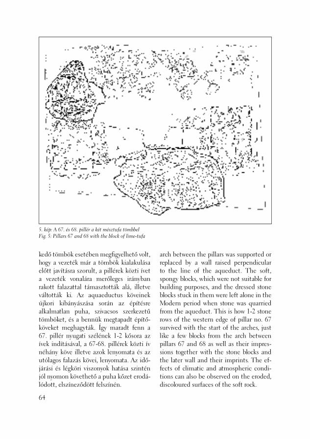
5. kép: A 67. és 68. pillér a két mésztufa tömbbelFig. 5: Pillars 67 and 68 with the block of lime-tufa
kedő tömbök esetében megfi gyelhető volt, hogy a vezeték már a tömbök kialakulása előtt javításra szorult, a pillérek közti ívet a vezeték vonalára merőleges irányban rakott falazattal támasztották alá, illetve váltották ki. Az aquaeductus köveinek újkori kibányászása során az építésre alkalmatlan puha, szivacsos szerkezetű tömböket, és a bennük megtapadt építő-köveket meghagyták. Így maradt fenn a 67. pillér nyugati szélének 1-2 kősora az ívek indításával, a 67-68. pillérek közti ív néhány köve illetve azok lenyomata és az utólagos falazás kövei, lenyomata. Az idő-járási és légköri viszonyok hatása szintén jól nyomon követhető a puha kőzet erodá-lódott, elszíneződött felszínén.
64
arch between the pillars was supported or replaced by a wall raised perpendicular to the line of the aqueduct. The soft, spongy blocks, which were not suitable for building purposes, and the dressed stone blocks stuck in them were left alone in the Modern period when stone was quarried from the aqueduct. This is how 1-2 stone rows of the western edge of pillar no. 67 survived with the start of the arches, just like a few blocks from the arch between pillars 67 and 68 as well as their impres-sions together with the stone blocks and the later wall and their imprints. The ef-fects of climatic and atmospheric condi-tions can also be observed on the eroded, discoloured surfaces of the soft rock.
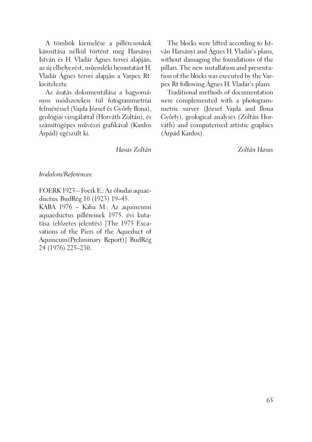
A tömbök kiemelése a pillércsonkok károsítása nélkül történt meg Harsányi István és H. Vladár Ágnes tervei alapján, az új elhelyezést, műemléki bemutatást H. Vladár Ágnes tervei alapján a Varpex Rt. kivitelezte. Az ásatás dokumentálása a hagyomá-nyos módszereken túl fotogrammetriai felméréssel (Vajda József és Győrfy Ilona), geológiai vizsgálattal (Horváth Zoltán), és számítógépes művészi grafi kával (Kardos Árpád) egészült ki.
Havas Zoltán
Irodalom/References:
FOERK 1923 – Foerk E.: Az óbudai aquae-ductus. BudRég 10 (1923) 19–45.KABA 1976 – Kaba M.: Az aquincumi aquaeductus pilléreinek 1975. évi kuta-tása (előzetes jelentés) [The 1975 Exca-vations of the Piers of the Aqueduct of Aquincum(Preliminary Report)] BudRég 24 (1976) 225–230.
The blocks were lifted according to Ist-ván Harsányi and Ágnes H. Vladár’s plans, without damaging the foundations of the pillars. The new installation and presenta-tion of the blocks was executed by the Var-pex Rt following Ágnes H. Vladár’s plans. Traditional methods of documentation were complemented with a photogram-metric survey (József Vajda and Ilona Győrfy), geological analyses (Zoltán Hor-váth) and computerised artistic graphics (Árpád Kardos).
Zoltán Havas
65

A szokatlan feladat az Záhony út – Szent-endrei út kereszteződésének átépítése során merült föl, a résztvevőket erős töprengésre és mérlegelésre késztetve annak tudomásul vétele után, hogy a megoldás elől – mely nem látszott köny-nyűnek – „nem lehet kitérni”, azt min-denképpen meg kell találni. Az aquaeductus még romjaiban is im-pozáns mérnöki alkotás – „műtárgy” –, melynek maradványai sok helyen látható-ak az egykori Impérium területén. Amikor a 19.-20. század fordulóján megkezdődtek a módszeres feltárások, már kevés volt meg a pillérekből. Új-kori mérnöki munkák – a Szentendrei út rendezése, a HÉV vonal kiépítése – is hozzájárultak a korábban jól látható rendszer megbontásához, a pillérek elér-hető részét pedig Óbuda lakói építőkő-nek hordták el. Az 1962-ben elkészült „Aquincum pol-gárváros távlati rendezési terve„ – mely első ízben foglalkozott a római rom-terület egységes „város”-ként történő kezelésével – kiemelkedő szerepet szánt a vízvezeték-rendszer egy szakasza rekon-strukciójának. Ez 1979-ben a polgárváros régészeti parkjával szemben készült el, a kiszélesített Szentendrei út középső – e célra szabadon hagyott – gyepesített sávjában, míg a csatlakozó szakaszokon a
A Szentendrei út – Záhony utca kereszteződésénél lévő római kori vízvezeték „pillér csonkok” technikai és műemlékvédelmi mentése
(Budapest, III. ker., Szentendrei út – Záhony utca kereszteződés)
66
Technical and monument rescue of the “pillar butts” of the Roman aqueduct at the intersection of Szentendrei Road and Záhony Street
(Budapest III, Szentendrei Road – Záhony Street intersection)
The unusual task of removing the aque-duct “pillar butts” arose as a consequence of the reconstruction at the intersection of Záhony Street and Szentendrei Street. The participants in this work were forced to seriously consider and evaluate the situ-ation after it turned out that problem’s solution, which did not seem at all simple, could not be evaded. Aqueduct remains, an imposing engi-neering product even today, can be seen in numerous parts of the former Roman Empire. When systematic excavation began at the turn of the 19th and 20th centuries very few of the aqueduct pillars still existed. Modern engineering works, such as the regulation of Szentendrei Road and the establishment of the HÉV suburban rail line, contributed to the dissection of the formerly clearly visible system. In addi-tion, the inhabitants Óbuda from the end of the Roman Empire used the stones of the pillars they could move to build their houses. The “Long-term development plan for the Civil Town of Aquincum” was pre-pared in 1962. It was the fi rst to deal with the Roman ruins as a complex “town”. The plan included a major role to the re-construction of a stretch of the aqueduct system. These aims were realised in 1979
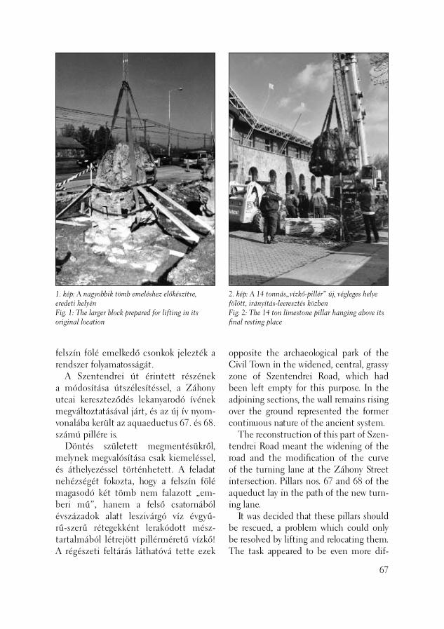
1. kép: A nagyobbik tömb emeléshez előkészítve, eredeti helyénFig. 1: The larger block prepared for lifting in its original location
2. kép: A 14 tonnás„vízkő-pillér” új, végleges helye fölött, irányítás-leeresztés közbenFig. 2: The 14 ton limestone pillar hanging above its fi nal resting place
felszín fölé emelkedő csonkok jelezték a rendszer folyamatosságát. A Szentendrei út érintett részének a módosítása útszélesítéssel, a Záhony utcai kereszteződés lekanyarodó ívének megváltoztatásával járt, és az új ív nyom-vonalába került az aquaeductus 67. és 68. számú pillére is. Döntés született megmentésükről, melynek megvalósítása csak kiemeléssel, és áthelyezéssel történhetett. A feladat nehézségét fokozta, hogy a felszín fölé magasodó két tömb nem falazott „em-beri mű”, hanem a felső csatornából évszázadok alatt leszivárgó víz évgyű-rű-szerű rétegekként lerakódott mész-tartalmából létrejött pillérméretű vízkő! A régészeti feltárás láthatóvá tette ezek
opposite the archaeological park of the Civil Town in the widened, central, grassy zone of Szentendrei Road, which had been left empty for this purpose. In the adjoining sections, the wall remains rising over the ground represented the former continuous nature of the ancient system. The reconstruction of this part of Szen-tendrei Road meant the widening of the road and the modifi cation of the curve of the turning lane at the Záhony Street intersection. Pillars nos. 67 and 68 of the aqueduct lay in the path of the new turn-ing lane. It was decided that these pillars should be rescued, a problem which could only be resolved by lifting and relocating them. The task appeared to be even more dif-
67
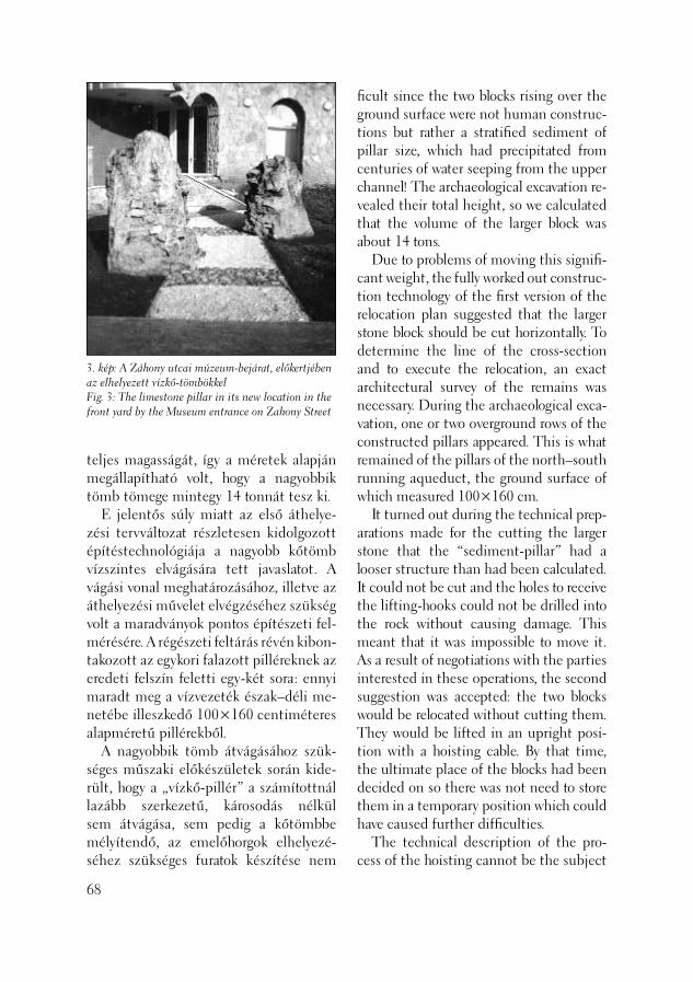
3. kép: A Záhony utcai múzeum-bejárat, előkertjében az elhelyezett vízkő-tömbökkelFig. 3: The limestone pillar in its new location in the front yard by the Museum entrance on Zahony Street
teljes magasságát, így a méretek alapján megállapítható volt, hogy a nagyobbik tömb tömege mintegy 14 tonnát tesz ki. E jelentős súly miatt az első áthelye-zési tervváltozat részletesen kidolgozott építéstechnológiája a nagyobb kőtömb vízszintes elvágására tett javaslatot. A vágási vonal meghatározásához, illetve az áthelyezési művelet elvégzéséhez szükség volt a maradványok pontos építészeti fel-mérésére. A régészeti feltárás révén kibon-takozott az egykori falazott pilléreknek az eredeti felszín feletti egy-két sora: ennyi maradt meg a vízvezeték észak–déli me-netébe illeszkedő 100×160 centiméteres alapméretű pillérekből. A nagyobbik tömb átvágásához szük-séges műszaki előkészületek során kide-rült, hogy a „vízkő-pillér” a számítottnál lazább szerkezetű, károsodás nélkül sem átvágása, sem pedig a kőtömbbe mélyítendő, az emelőhorgok elhelyezé-séhez szükséges furatok készítése nem
68
fi cult since the two blocks rising over the ground surface were not human construc-tions but rather a stratifi ed sediment of pillar size, which had precipitated from centuries of water seeping from the upper channel! The archaeological excavation re-vealed their total height, so we calculated that the volume of the larger block was about 14 tons. Due to problems of moving this signifi -cant weight, the fully worked out construc-tion technology of the fi rst version of the relocation plan suggested that the larger stone block should be cut horizontally. To determine the line of the cross-section and to execute the relocation, an exact architectural survey of the remains was necessary. During the archaeological exca-vation, one or two overground rows of the constructed pillars appeared. This is what remained of the pillars of the north–south running aqueduct, the ground surface of which measured 100×160 cm. It turned out during the technical prep-arations made for the cutting the larger stone that the “sediment-pillar” had a looser structure than had been calculated. It could not be cut and the holes to receive the lifting-hooks could not be drilled into the rock without causing damage. This meant that it was impossible to move it. As a result of negotiations with the parties interested in these operations, the second suggestion was accepted: the two blocks would be relocated without cutting them. They would be lifted in an upright posi-tion with a hoisting cable. By that time, the ultimate place of the blocks had been decided on so there was not need to store them in a temporary position which could have caused further diffi culties. The technical description of the pro-cess of the hoisting cannot be the subject
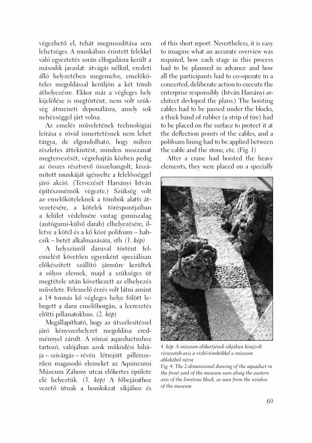
4. kép: A múzeum előkertjének síkjában kirajzolt vízvezeték-axis a vízkő-tömbökkel a múzeum ablakából nézveFig. 4: The 2-dimensional drawing of the aquaduct in the front yard of the museum seen along the eastern axis of the limstone block, as seen from the window of the museum
végezhető el, tehát megmozdítása sem lehetséges. A munkában érintett felekkel való egyeztetés során elfogadásra került a második javaslat: átvágás nélkül, eredeti álló helyzetében megemelve, emelőkö-teles megoldással kerüljön a két tömb áthelyezésre. Ekkor már a végleges hely kijelölése is megtörtént, nem volt szük-ség átmeneti deponálásra, amely sok nehézséggel járt volna. Az emelés műveletének technológiai leírása e rövid ismertetésnek nem lehet tárgya, de elgondolható, hogy milyen részletes áttekintést, minden mozzanat megtervezését, végrehajtás közben pedig az összes résztvevő összehangolt, kiszá-mított munkáját igényelte a felelősséggel járó akció. (Tervezését Harsányi István építészmérnök végezte.) Szükség volt az emelőköteleknek a tömbök alatti át-vezetésére, a kötelek töréspontjaiban a felület védelmére vastag gumiszalag (autógumi-külső darab) elhelyezésére, il-letve a kötél és a kő közé polifoam – hab-csík – betét alkalmazására, stb. (1. kép) A helyszínről daruval történt fel-emelést követően egyenként speciálisan előkészített szállító járműre kerültek a súlyos elemek, majd a szükséges út megtétele után következett az elhelyezés művelete. Felemelő érzés volt látni amint a 14 tonnás kő végleges helye fölött le-begett a daru emelőhorgán, a leeresztés előtti pillanatokban. (2. kép) Megállapítható, hogy az útszélesítéssel járó kényszerhelyzet megoldása ered-ménnyel zárult. A római aqaeductushoz tartozó, valójában azok működési hibá-ja – szivárgás – révén létrejött pillérsze-rűen magasodó elemeket az Aquincumi Múzeum Záhony utcai előkertes épülete elé helyeztük. (3. kép) A főbejárathoz vezető útnak a homlokzat síkjához és
of this short report. Nevertheless, it is easy to imagine what an accurate overview was required, how each stage in this process had to be planned in advance and how all the participants had to co-operate in a concerted, deliberate action to execute the enterprise responsibly. (István Harsányi ar-chitect devloped the plans.) The hoisting cables had to be passed under the blocks, a thick band of rubber (a strip of tire) had to be placed on the surface to protect it at the defl ection points of the cables, and a polifoam lining had to be applied between the cable and the stone, etc. (Fig. 1) After a crane had hoisted the heavy elements, they were placed on a specially
69
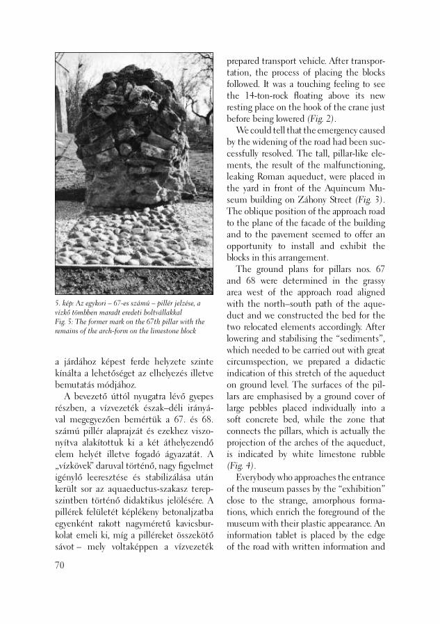
5. kép: Az egykori – 67-es számú – pillér jelzése, a vízkő tömbben maradt eredeti boltvállakkalFig. 5: The former mark on the 67th pillar with the remains of the arch-form on the limestone block
a járdához képest ferde helyzete szinte kínálta a lehetőséget az elhelyezés illetve bemutatás módjához. A bevezető úttól nyugatra lévő gyepes részben, a vízvezeték észak–déli irányá-val megegyezően bemértük a 67. és 68. számú pillér alaprajzát és ezekhez viszo-nyítva alakítottuk ki a két áthelyezendő elem helyét illetve fogadó ágyazatát. A „vízkövek” daruval történő, nagy fi gyelmet igénylő leeresztése és stabilizálása után került sor az aquaeductus-szakasz terep-szintben történő didaktikus jelölésére. A pillérek felületét képlékeny betonaljzatba egyenként rakott nagyméretű kavicsbur-kolat emeli ki, míg a pilléreket összekötő sávot – mely voltaképpen a vízvezeték
70
prepared transport vehicle. After transpor-tation, the process of placing the blocks followed. It was a touching feeling to see the 14-ton-rock fl oating above its new resting place on the hook of the crane just before being lowered (Fig. 2). We could tell that the emergency caused by the widening of the road had been suc-cessfully resolved. The tall, pillar-like ele-ments, the result of the malfunctioning, leaking Roman aqueduct, were placed in the yard in front of the Aquincum Mu-seum building on Záhony Street (Fig. 3). The oblique position of the approach road to the plane of the facade of the building and to the pavement seemed to offer an opportunity to install and exhibit the blocks in this arrangement. The ground plans for pillars nos. 67 and 68 were determined in the grassy area west of the approach road aligned with the north–south path of the aque-duct and we constructed the bed for the two relocated elements accordingly. After lowering and stabilising the “sediments”, which needed to be carried out with great circumspection, we prepared a didactic indication of this stretch of the aqueduct on ground level. The surfaces of the pil-lars are emphasised by a ground cover of large pebbles placed individually into a soft concrete bed, while the zone that connects the pillars, which is actually the projection of the arches of the aqueduct, is indicated by white limestone rubble (Fig. 4). Everybody who approaches the entrance of the museum passes by the “exhibition” close to the strange, amorphous forma-tions, which enrich the foreground of the museum with their plastic appearance. An information tablet is placed by the edge of the road with written information and

boltíveinek vetülete – fehér mészkőzúza-lék jelzi. (4. kép) Mindenki, aki a múzeum bejáratához tart, elhalad a „kiállítás” mellett, kar-nyújtásnyira a különös amorf képződmé-nyektől, melyek plasztikai megjelenésük-kel is gazdagítják a múzeum előterét. A kis út szegélyénél elhelyezett információs tábla tájékoztató szöveggel, rekonstrukci-ós rajzzal nemcsak ezt a látványt magya-rázza, hanem mintegy „közel hozza” és értelmezi a Szentendrei út közepén lévő római vízvezeték nehezen megközelíthe-tő „in situ” részleteit is. (5. kép)
Vladár Ágnes
a reconstruction drawing. It not only ex-plains the view but also interprets and ac-quaints the visitor with the less accessible “in situ” details of the Roman aqueduct runing down the middle of Szentendrei Road (Fig. 5).
Ágnes Vladár
71
2003. április 22. – június 16. között, több helyszínen próbafeltárást végeztünk a III. ker., Szentendrei út – Záhony utca – Jégtö-rő utca által határolt területen, a volt Ház-gyár területén épülő Auchan bevásárlóköz-pont munkálataihoz kapcsolódva. (1. kép) Az építkezés két hangsúlyos területének megfelelően a munka célja – a Záhony ut-ca tervezett szélesítése miatt az utca alatt fekvő régészeti emlékek, valamint az épí-tési telken belüli mélyebb alapozású köz-művek, csatorna nyomvonalának – feltárása volt. Az aquincumi polgárváros előteréből számos régészeti emlék került be már ko-rábban is a múzeumba, s több leletmentést végeztek itt a múzeum munkatársai. 1997 és 2000 között már szisztematikus kutatás folyt a területen, amely egy több periódusú árokrendszert és könnyű szerkezetű épület maradványokat, valamint 2.–4./5. századi, vegyes rítusú temetőrészletet hoztak fel-színre. (Összefoglalóan: ZSIDI 2002) Első lépésben a Szentendrei út és Zá-hony utca sarkán húztunk 24×5 méteres kelet–nyugati kutatatóárkot („A” szonda). (2. kép) A szondát északkelet–délnyugati irányban keresztezte egy főnyomócső több méter széles sávja, valamint megtaláltuk egy korábbi, Nagy Lajos által végzett ása-tás kutatóárkát is, kelet–nyugati irányban. E két újkori objektum négy részre vágta a felületet.
Feltárások az aquincumi polgárváros délkeleti előterében
(Budapest, III. ker., Szentendrei út – Záhony utca, Szentendrei út 101–105.)
72
Excavations in the southeastern foreground of the Aquincum Civil Town
(Budapest III Szentendrei Road – Záhony Street, Szentendrei Road, Ln: 101–105.)
Between April 22 and June 16, 2003, we conducted test excavations at several spots in the territory bounded by Szentendrei Road, Záhony Street and Jégtörő Street in connection with the construction of the Auchan shopping center on the terri-tory of the former House Factory (Fig. 1). Regarding the two areas impacted by the construction, we aimed to unearth the archaeological features beneath Záhony Street, which was to be widened, and the track of public utilities and a channel, which would be dug deep into the con-struction site. Numerous archaeological remains have already been come to the museum from the foreground of the Aquincum Civil Town and the museum archaeologists have conducted many res-cue excavations in this area. A systematic investigation was carried out in the ter-ritory between 1997 and 2000. during the course of these excavations, remains of a trench system from several periods, a light-structure building and part of a AD 2nd–4th/5th century cemetery with di-verse rites were unearthed (See summary: ZSIDI 2002). First, a 24×5 m east–west oriented test trench (trench “A”) was opened at the corner of Szentendrei Road and Záhony Street (Fig. 2). A water main intersected the test trench for a couple of meters in

A szonda nyugati részében felszínre került Aquincum polgárvárosát a Flórián téri legiótáborral összekötő észak–déli, köves, sóderes szerkezetű római kori főút-vonal sávja. (5. kép) Az út keleti szegélyét a főnyomócső beásása részben vágta, nyugati irányban pedig a metszetfal alá húzódott az útfelület. A feltárás során az út öt peri ódusát sikerült elkülönítenünk. A legalsó útréteget, a humusz legyalu-lását követően, a sárga agyagos altalajra alapozták. A sóderes útalapozás-fázisok között természetes feltöltődési rétegeket találunk. Ezek közül az első – a geológia vizsgálatok szerint, melyeket Mindszenty Andrea és Horváth Zoltán az ELTE Alkal-mazott- és Környezetföldtani Tanszéké-nek munkatársai végeztek, – ártéri üle-déket tartalmaz, amely arra utal, hogy ezt az utat nagyobb áradás idején elöntötte a Duna. Az útfázisok közül felszínre került
a broad northeast–southwest oriented zone. Here, we found the east–west run-ning test trench from a former excavation conducted by Lajos Nagy. These two mod-ern features bisected the surface into four parts. A strip of the north–south oriented main road from the Roman period came to light in the western part of the test trench (Fig. 5). This road, which had a stony, gravely structure, connected the Civil Town of Aquincum with the legion-ary fortress on Flórián Square. The water main trench intersected the eastern edge of the road, while to the west, the road surface extended under the section wall. Five periods of road building could be differentiated during the excavation. The lowermost road layer was founded on the yellow clayey ground after the humus was scraped off. Natural deposits were found
73
1. kép: A próbafeltárás helyszíneiFig. 1: Locations of the test excavations
2. kép: Az „A” szonda keletrőlFig. 2: Trench “A” from the East
leletek a Kr. u. 2.-3. századból származ-nak. Az ennél későbbi rétegeket a későbbi bolygatás elpusztította. A szonda keleti felében, melyet az úttól a főnyomócső árka vágott el, ugyancsak legalább öt jelentősebb építési periódus-hoz köthető épületrészt találtunk. Az I., legkorábbi periódushoz cölöpszerkezetes épület csekély maradványai tartoznak, amely valószínűleg egykorú a legkorábbi útréteggel. Folyamatos kelet–nyugati ré-tegsort sajnos a főnyomócső miatt nem tudtunk megfi gyelni. A II. periódusból csak két kisebb, köves falalapozás maradt meg. E két, legkorábbi periódusból első-sorban 2. századi leletanyag került elő. Jelentős volt a III., valószínűleg Seve-rus-kori építési periódus, melyet kőalapo-
74
between the gravely road foundation phases. The fi rst contained fl oodplain de-posits according to the geological analyses carried out by Andrea Mindszenty and Zoltán Horváth from the Department of Applied and Environmental Geology of the ELTE. It seems that fl oodwaters from the Danube inundated the road during a large fl ood. The fi nds recovered from inter-road phases dated to the AD 2nd-3rd centuries. The subsequent layers were de-stroyed by later disturbances. In the eastern part of the test trench, cut off from the road by the water main trench, we found part of a building which also had at least fi ve signifi cant construction periods. Scattered remains of a post-structure building belonged to the earliest phase I. This building phase was probably contemporary with the earli-est road layer. Regrettably, no continuous stratigraphic sequence could be observed in the layer sequence in the east–west profi le because of the disturbance from the water main. Only two small stone wall foundations were preserved from period II. These two earliest periods mostly yielded fi nds from the AD 2nd century. Construction period III, probably from the Severine period, was signifi cant. It is represented by three rooms of an adobe-walled building on a stone founda-tion. The northeastern room facing the road must have been open towards the west. The northern part of the building burned down at the end of period III, and the entire building collapsed (Fig. 6). This destruction layer is most probably identi-cal with the destruction layer of the pot-tery unearthed by the Schütz restaurant, linked to the Barbarian invasion in AD 214 or 231 (BÓNIS 1993, 231). The two silver coins from the Severine period (Julia
4. kép: Geta (?) ezüst érmeFig. 4: Silver coin of Geta (?)
3. kép: Julia Soemia érmeFig. 3: The Julia Soemia silver coin
zású vályogtégla épület három helyisége képvisel. Az északkeleti helyiség az út felé valószínűleg nyitott lehetett nyugati irányban. Az épület északi része a III. periódus végén leégett, az egész épület összeomlott. (6. kép) Ez a pusztulási réteg minden valószínűség szerint azonos a Schütz vendéglőnél feltárt fazekasműhely pusztulási rétegével, amelyet az eddigi kutatás esetleg a 212–214-es vagy 231-es barbár betöréssel hozott összefüggésbe. (BÓNIS 1993, 231) A pusztulási réteget lezáró szintből előkerült két Severus-kori
Soemia and Geta ?) (Figs. 3-4) recovered from the closed level of the destruction layer corroborate this dating, although the thick burnt layer around the potters’ ovens need not necessarily be associated with a violent event. In period IV, the burnt debris was lev-eled, but only the northeastern room was reconstructed and the southern wall reinforced by a buttress. Only traces of the fl oor level of the room were preserved. This phase can probably be dated from the fi rst half and the middle of the AD 3rd century. A 0.2–0.25 m thick leveling layer of lime and debris and the stone rows of a wall corner, preserved to a relatively great height, represent the latest period V at the end of the test trench. The exact date and function of this feature is not yet known. The remains unearthed in test trench “A” can be linked with the building con-structed along the eastern side of the main road that left the Civil Town towards the south. It had an open portico facing the main road to the west. Further investi-gations and the identifi cation of the exact place of Lajos Nagy’s excavation in 1932 my help to clarify the connection between the building and the pottery found by the Schütz restaurant. It seems more likely, however, that this building had a commer-cial purpose connect with its location on the main road. Test trench “B” was opened east of trench “A” on Záhony Street, parallel with the new Aquincum Museum building. It was opened in an east–west direction and measured 4×2.5 m. In the southern part of the test trench, we observed a, more-or-less, east–west oriented segment of a stone wall foundation at a signifi cant depth beneath the modern ground sur-
75
(Julia Soemia és Geta ?) ezüst érem (3-4. kép) megerősíti ezt a datálást, bár égető kemencék közelében nem kell fel-tétlenül erőszakos eseményre gondolunk a vastag égési réteg kapcsán. A IV. periódusban, elplanírozva az égési törmeléket, csak az északkeleti helyiséget építették újjá, melynek déli fala egy tá-masztópillért kapott, a helyiséghez tartozó járószint csak nyomokban található meg. Ez a fázis feltehetőleg a 3. század első felé-re, közepére keltezhető. A legkésőbbi, V. periódust a szonda végében egy 0,2–0,25 méter vastag meszes, épülettörmelékes planírozás és egy falsarok magasan meg-maradt kősorai jelentik, amelynek pontos kora és funkciója egyelőre ismeretlen. Az „A” szondában feltárt maradvá-nyokat a polgárvárosból déli irányban kivezető főútvonal keleti széle mentén
76
5. kép: A polgárvárost a canabaeval összekötő főút rétegeiFig. 5: Layers of the main road that connected the Civil T
face. A shallow, east–west running ditch was also outlined in the brown humus. Test trench “C”, which measured 3×3 m, contained only natural soil layers inside the construction site under several meters of a modern cinder layer. Test trench “D”, measuring 50×4 m, was opened in an east–west direction in the southern part of the construction site. Natural soil layers were observed under the modern cinder layer, in which a 0.5 m thick adobe wall from a north–south directed modern construction was recov-ered. Interestingly, the sandy substratum in this zone sloped upwards in an easterly direction, towards the Danube, while it declined towards Szentendrei Road to the west as if running into a ditch. This appears to be just the opposite of what we observed north of the trench. We could
az „A” szondábanown with the canabae in trench “A”
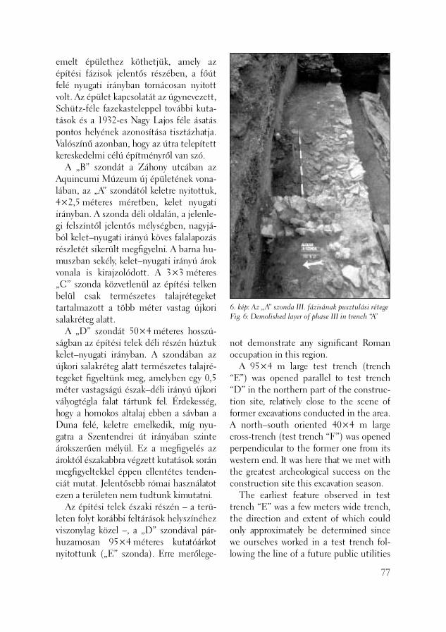
6. kép: Az „A” szonda III. fázisának pusztulási rétegeFig. 6: Demolished layer of phase III in trench “A”
emelt épülethez köthetjük, amely az építési fázisok jelentős részében, a főút felé nyugati irányban tornácosan nyitott volt. Az épület kapcsolatát az úgynevezett, Schütz-féle fazekasteleppel további kuta-tások és a 1932-es Nagy Lajos féle ásatás pontos helyének azonosítása tisztázhatja. Valószínű azonban, hogy az útra telepített kereskedelmi célú építményről van szó. A „B” szondát a Záhony utcában az Aquincumi Múzeum új épületének vona-lában, az „A” szondától keletre nyitottuk, 4×2,5 méteres méretben, kelet nyugati irányban. A szonda déli oldalán, a jelenle-gi felszíntől jelentős mélységben, nagyjá-ból kelet–nyugati irányú köves falalapozás részletét sikerült megfi gyelni. A barna hu-muszban sekély, kelet–nyugati irányú árok vonala is kirajzolódott. A 3×3 méteres „C” szonda közvetlenül az építési telken belül csak természetes talajrétegeket tar tal mazott a több méter vastag újkori salakréteg alatt. A „D” szondát 50×4 méteres hosszú-ságban az építési telek déli részén húztuk kelet–nyugati irányban. A szondában az újkori salakréteg alatt természetes talajré-tegeket fi gyeltünk meg, amelyben egy 0,5 méter vastagságú észak–déli irányú újkori vályogtégla falat tártunk fel. Érdekesség, hogy a homokos altalaj ebben a sávban a Duna felé, keletre emelkedik, míg nyu-gatra a Szentendrei út irányában szinte árokszerűen mélyül. Ez a megfi gyelés az ároktól északabbra végzett kutatások során megfi gyeltekkel éppen ellentétes tenden-ciát mutat. Jelentősebb római használatot ezen a területen nem tudtunk kimutatni. Az építési telek északi részén – a terü-leten folyt korábbi feltárások helyszínéhez viszonylag közel –, a „D” szondával pár-huzamosan 95×4 méteres kutatóárkot nyitottunk („E” szonda). Erre merőlege-
not demonstrate any signifi cant Roman occupation in this region. A 95×4 m large test trench (trench “E”) was opened parallel to test trench “D” in the northern part of the construc-tion site, relatively close to the scene of former excavations conducted in the area. A north–south oriented 40×4 m large cross-trench (test trench “F”) was opened perpendicular to the former one from its western end. It was here that we met with the greatest archeological success on the construction site this excavation season. The earliest feature observed in test trench “E” was a few meters wide trench, the direction and extent of which could only approximately be determined since we ourselves worked in a test trench fol-lowing the line of a future public utilities
77
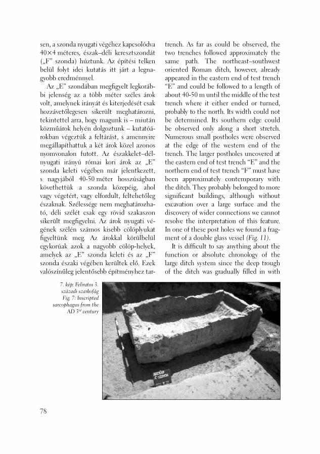
sen, a szonda nyugati végéhez kapcsolódva 40×4 méteres, észak–déli keresztszondát („F” szonda) húztunk. Az építési telken belül folyt idei kutatás itt járt a legna-gyobb eredménnyel. Az „E” szondában megfi gyelt legkoráb-bi jelenség az a több méter széles árok volt, amelynek irányát és kiterjedését csak hozzávetőlegesen sikerült meghatározni, tekintettel arra, hogy magunk is – miután közműárok helyén dolgoztunk – kutatóá-rokban végeztük a feltárást, s amennyire megállapíthattuk a két árok közel azonos nyomvonalon futott. Az északkelet–dél-nyugati irányú római kori árok az „E” szonda keleti végében már jelentkezett, s nagyjából 40-50 méter hosszúságban követhettük a szonda közepéig, ahol vagy végetért, vagy elfordult, feltehetőleg északnak. Szélessége nem meghatározha-tó, déli szélét csak egy rövid szakaszon sikerült megfi gyelni. Az árok nyugati vé-gének szélén számos kisebb cölöplyukat fi gyeltünk meg. Az árokkal körülbelül egykorúak azok a nagyobb cölöp-helyek, amelyek az „E” szonda keleti és az „F” szonda északi végében kerültek elő. Ezek valószínűleg jelentősebb építményhez tar-
78
7. kép: Feliratos 3. századi szarkofágFig. 7: Inscripted
sarcophagus from the AD 3rd century
trench. As far as could be observed, the two trenches followed approximately the same path. The northeast–southwest oriented Roman ditch, however, already appeared in the eastern end of test trench “E” and could be followed to a length of about 40-50 m until the middle of the test trench where it either ended or turned, probably to the north. Its width could not be determined. Its southern edge could be observed only along a short stretch. Numerous small postholes were observed at the edge of the western end of the trench. The larger postholes uncovered at the eastern end of test trench “E” and the northern end of test trench “F” must have been approximately contemporary with the ditch. They probably belonged to more signifi cant buildings, although without excavation over a large surface and the discovery of wider connections we cannot resolve the interpretation of this feature. In one of these post holes we found a frag-ment of a double glass vessel (Fig. 11). It is diffi cult to say anything about the function or absolute chronology of the large ditch system since the deep trough of the ditch was gradually fi lled in with
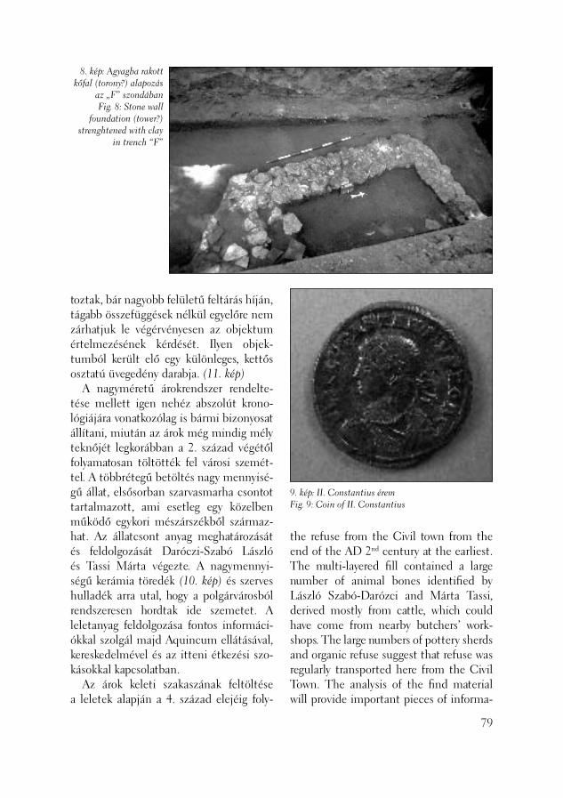
8. kép: Agyagba rakott kőfal (torony?) alapozás
az „F” szondábanFig. 8: Stone wall
foundation (tower?) strenghtened with clay
in trench “F”
9. kép: II. Constantius éremFig. 9: Coin of II. Constantius
toztak, bár nagyobb felületű feltárás híján, tágabb összefüggések nélkül egyelőre nem zárhatjuk le végérvényesen az objektum értelmezésének kérdését. Ilyen objek-tumból került elő egy különleges, kettős osztatú üvegedény darabja. (11. kép) A nagyméretű árokrendszer rendelte-tése mellett igen nehéz abszolút krono-lógiájára vonatkozólag is bármi bizonyosat állítani, miután az árok még mindig mély teknőjét legkorábban a 2. század végétől folyamatosan töltötték fel városi szemét-tel. A többrétegű betöltés nagy mennyisé-gű állat, elsősorban szarvasmarha csontot tartalmazott, ami esetleg egy közelben működő egykori mészárszékből származ-hat. Az állatcsont anyag meghatározását és feldolgozását Daróczi-Szabó László és Tassi Márta végezte. A nagymennyi-ségű kerámia töredék (10. kép) és szerves hulladék arra utal, hogy a polgárvárosból rendszeresen hordtak ide szemetet. A leletanyag feldolgozása fontos informáci-ókkal szolgál majd Aquincum ellátásával, kereskedelmével és az itteni étkezési szo-kásokkal kapcsolatban. Az árok keleti szakaszának feltöltése a leletek alapján a 4. század elejéig foly-
the refuse from the Civil town from the end of the AD 2nd century at the earliest. The multi-layered fi ll contained a large number of animal bones identifi ed by László Szabó-Darózci and Márta Tassi, derived mostly from cattle, which could have come from nearby butchers’ work-shops. The large numbers of pottery sherds and organic refuse suggest that refuse was regularly transported here from the Civil Town. The analysis of the fi nd material will provide important pieces of informa-
79
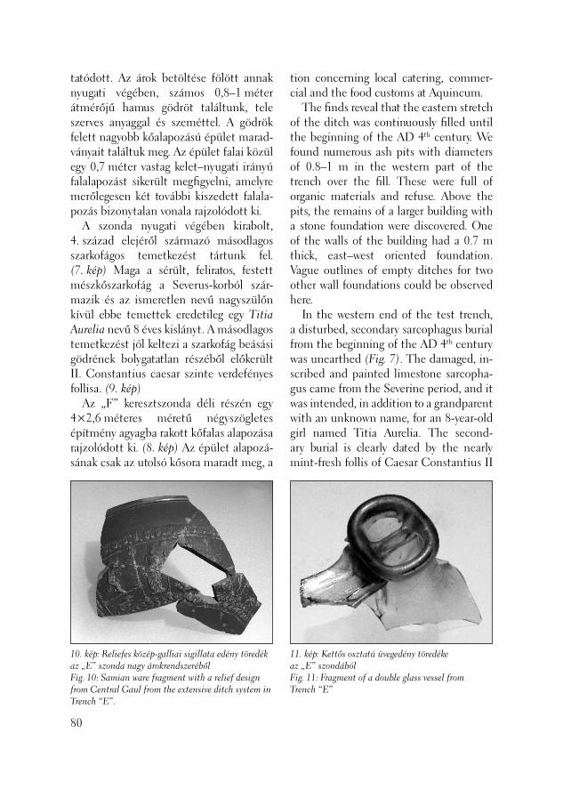
tatódott. Az árok betöltése fölött annak nyugati végében, számos 0,8–1 méter átmérőjű hamus gödröt találtunk, tele szerves anyaggal és szeméttel. A gödrök felett nagyobb kőalapozású épület marad-ványait találtuk meg. Az épület falai közül egy 0,7 méter vastag kelet–nyugati irányú falalapozást sikerült megfi gyelni, amelyre merőlegesen két további kiszedett falala-pozás bizonytalan vonala rajzolódott ki. A szonda nyugati végében kirabolt, 4. század elejéről származó másodlagos szarkofágos temetkezést tártunk fel. (7. kép) Maga a sérült, feliratos, festett mészkőszarkofág a Severus-korból szár-mazik és az ismeretlen nevű nagyszülőn kívül ebbe temettek eredetileg egy Titia Aurelia nevű 8 éves kislányt. A másodlagos temetkezést jól keltezi a szarkofág beásási gödrének bolygatatlan részéből előkerült II. Constantius caesar szinte verdefényes follisa. (9. kép) Az „F” keresztszonda déli részén egy 4×2,6 mé te res méretű négyszögletes épít mény agyagba rakott kőfalas alapozása rajzolódott ki. (8. kép) Az épület alapozá-sának csak az utolsó kősora maradt meg, a
80
10. kép: Reliefes közép-galliai sigillata edény töredék az „E” szonda nagy árokrendszerébőlFig. 10: Samian ware fragment with a relief design from Central Gaul from the extensive ditch system in Trench “E”.
tion concerning local catering, commer-cial and the food customs at Aquincum. The fi nds reveal that the eastern stretch of the ditch was continuously fi lled until the beginning of the AD 4th century. We found numerous ash pits with diameters of 0.8–1 m in the western part of the trench over the fi ll. These were full of organic materials and refuse. Above the pits, the remains of a larger building with a stone foundation were discovered. One of the walls of the building had a 0.7 m thick, east–west oriented foundation. Vague outlines of empty ditches for two other wall foundations could be observed here. In the western end of the test trench, a disturbed, secondary sarcophagus burial from the beginning of the AD 4th century was unearthed (Fig. 7). The damaged, in-scribed and painted limestone sarcopha-gus came from the Severine period, and it was intended, in addition to a grandparent with an unknown name, for an 8-year-old girl named Titia Aurelia. The second-ary burial is clearly dated by the nearly mint-fresh follis of Caesar Constantius II
11. kép: Kettős osztatú üvegedény töredéke az „E” szondábólFig. 11: Fragment of a double glass vessel from Trench “E”
keresztfalak folytatását kelet felé az újkori bolygatás eltüntette. A talán 4. századi építmény megmaradt része méretében és formájában leginkább őrtoronyra em-lékeztet, közvetlenül mellőle Aurelianus császár kisbronza került elő. A szonda déli részben további, kelet–nyugati irányú fala-lapozást és cölöplyukakat fi gyeltünk meg. Összességében a „E” és az „F” szondá-ban kirajzolódott kép alapján úgy tűnik, hogy a terület északi részén megfi gyelt főút menti temetőben (ZSIDI 2002, 145–146) déli irányban már csak szór-ványos betemetkezések voltak. A Duna irányában pedig a 3. század eleje után több korszakban, különböző rendeltetésű kőépületet is emeltek a korai, feltöltött árok mellett, illetve tetején.
Lassányi Gábor – Zsidi Paula
Irodalom/References:
BÓNIS 1993 – B. Bónis, É.: Töpferei an der Südmauer der Aquincumer Zivilstadt neben dem „Schütz-Gasthof“. (Fazekas-telep az aquincumi polgárváros déli, a „Schütz vendéglő” mellett.) BudRég 30 (1993), 229–243.ZSIDI 2002 – Zsidi P.: Az aquincumi polgárváros délkeleti előtere az újabb kutatások tükrében. (Der südöstliche Vorraum der Zivilstadt von Aquincum im Spiegel der neueren Forschung) BudRég 35 (2002), 143–157.
found in the undisturbed part of the shaft for the sarcophagus (Fig. 9). In the southern part of cross-trench “F”, the stone foundation of a 4×2.6 m square building was found laid into the clay (Fig. 8). Only the last stone row of the foundation was preserved since modern disturbances have destroyed the continua-tion of the traverse walls towards the east. The measurements and the shape of the preserved part of the building, perhaps dating to the AD 4th century are remi-niscent of a watchtower. A small bronze coin of Emperor Aurelianus was recovered next to it. In the southern part of the test trench we could observe some other wall foundations and postholes running in a east–west direction. The picture which can be drawn from the features in test trenches “E” and “F” shows on the whole that there were only a few scattered burials towards the south in the cemetery along the main road ob-served in the northern part of the territory (ZSIDI 2002, 145-146). From the begin-ning of the AD 3rd century, stone buildings with diverse functions were constructed in various periods along and over the early, fi lled-in trench in the direction of the Danube.
Gábor Lassányi – Paula Zsidi
81

A BTM Aquincumi Múzeuma a terü-let megelőző régészeti feltárását lakó-park-építés kapcsán végezte 2003. április 18. és június 11. között. A kutatásokat indokolta, hogy terület az aquincumi polgárváros északkeleti, illetve a település keleti temetőjének (az úgynevezett Gázgyári temetőnek) köz-vetlen északi szomszédságában található. Ez utóbbi északi határát a korábbi kuta-tás – szórványleletek alapján (SAS 1831, 130–131) – az „esztegomi vasúti töltésen túlra”, az egykori Illés-malom zónájában húzta meg. (NAGY 1942, 469) Ez a te-rület – egy 1912. évi Budapest-térkép alapján – a jelen telekkel szemben, a Nánási út keleti oldalán található. A 20. század elején meginduló szisztematikus régészeti feltárások azonban ezt a terüle-tet nem érintették, elsősorban a Gázgyár kiépítéséhez és további fejlesztéseihez kapcsolódtak (úgynevezett gázgyári fa-zekastelep és temetőrészletek feltárása). A területhez topográfi aliag legközelebb Szilágyi János dolgozott, aki a közelben regisztrálta az északi városfal egy szaka-szát, egy kis toronnyal. (SZILÁGYI 1950, 311–312) A fentiek mellett várható volt még esetleg a limesút, illetve a keleti vá-rosfal előkerülése is. A területen első lépésben szondázó jel-legű kutatást folytattunk, amelyet megelő-
Római kori temetőrészlet az aquincumi polgárváros északkeleti szomszédságában
(Budapest, III. ker., Pók utca – Nánási út – Városfal utca, Hrsz.: 23152/297)
82
Preceding the construction of an apart-ment complex the Aquincum Museum of the Budapest Historical Museum conducted archaeological excavations be-tween April 18 and June 11, 2003. The investigations were justifi ed by the fact that the territory is situated in the immediate neighbourhood of the Civil Town of Aquincum to its northeast, immediately north of the settlement’s eastern cemetery (the so-called Gas Factory cemetery). The northern border of the latter was located on the basis of stray fi nds (SAS 1831, 130-131) “beyond the embankment of the Esztergom rail-way”, in the zone of the former Illés mill (NAGY 1942, 469). In a map of Budapest from 1912, this territory can be found lying across the present lot, on the east-ern side of Nánási Road. The systematic archaeological excavations, which started at the beginning of the 20th century, did not extend into this territory but were primarily linked with the establishment and the development of the Gas Factory (the excavations of the so-called Gas Fac-tory pottery workshop and parts of a cem-etery). From a topographic point of view, J. Szilágyi worked closest to this territory. Not far from here, he noted the presence of a short stretch of the northern town wall with a small tower (SZILÁGYI 1950,
Part of a Roman period cemetery northeast of the Aquincum Civil Town
(Budapest III, Pók Street – Nánási Road – Városfal Street, Ln: 23152/297)

1. kép: Aquincum polgárvárosa és közvetlen környezete az ásatás helyszínévelFig. 1: Aquincum Civil Town and its surrondings with the location of the excavations
1. Amphiteátrum/Amphitheatre 2. Gladiátor laktanya/Gladiator barracks 3. Közfürdők/Public baths 4. Piac/Market place 5. Mithras szentély/Mithras sanctuary 6. Kerek szentély/Circular shrine 7. Fazekas telep/Pottery workshops 8. Temető/Cemetery 9. Őrtorony/Watchtower 10. Tűzoltó székház/Headquarters of the
Firemen’s Association 11. Az ásatás helyszíne/Location of the
excavation
1
2
3
4
5
6
5
5
8
9
10
3
7
11
ző feltárás követett. A munka során eddig négy periódust sikerült elkülönítenünk, amelyek közül kiemelhető egy római kori temető részlete. (1. kép) 1. A terület legalsó kutatott szintjén a Duna áradásaira jellemző sóderes szinte-ket dokumentáltunk. 2. Felette, a terület délnyugati részén kisebb homokos kiemelkedés következett, amelyen a római korra keltezhető temető-részlet került elő, negyven temetkezéssel. A sírok jelentős része melléklet nélküli fa-koporsós, csontvázas temetkezés volt. Né-hány esetben egy-egy edény vagy viseleti tárgy (például vörös bevonatos sárga korsó, sávos festésű, kék üvegpasztagyöngy) is került a halott mellé. A nagy részben igen szegényes temetke-zések között néhány „gazdagabb” mellék-letű sírt is dokumentálhattunk. A 8. sír
311-312). Beside the above, the limes road and the eastern town wall could be expected to run through this territory. In the fi rst phase of the work we con-ducted test excavations followed by the rescue operations. We could separate four periods so far, including a fragment of a Roman period cemetery (Fig. 1). 1. In the lowermost investigated level of the territory, we registered gravelly layers characteristically left by the fl oodwaters of the Danube. 2. This layer was overlain by a small, sandy elevation in the southwestern part of the territory. Here circa 40 burials from part of a Roman period cemetery were uncovered. Most of the graves contained skeletons in wooden coffi ns without grave-goods. In a few cases, one or two vessels or articles of wear (e.g. a red-slip
83
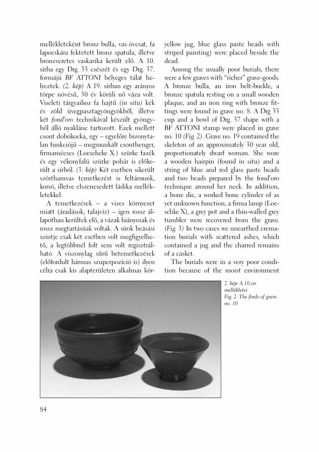
mellékleteként bronz bulla, vas övcsat, fa lapocskára fektetett bronz spatula, illetve bronzveretes vaskarika került elő. A 10. sírba egy Drg. 33 csészét és egy Drg. 37. formájú BF ATTONI bélyeges tálat he-lyeztek. (2. kép) A 19. sírban egy arányos törpe növésű, 30 év körüli nő váza volt. Viseleti tárgyaihoz fa hajtű (in situ) kék és zöld üvegpasztagyöngyökből, illetve két fond’oro technikával készült gyöngy-ből álló nyaklánc tartozott. Ezek mellett csont dobókocka, egy – egyelőre bizonyta-lan funkciójú – megmunkált csonthenger, fi rmamécses (Loeschcke X.) szürke fazék és egy vékonyfalú szürke pohár is előke-rült a sírból. (3. kép) Két esetben sikerült szórthamvas temetkezést is feltárnunk, korsó, illetve elszenesedett ládika mellék-letekkel. A temetkezések – a vizes környezet miatt (áradások, talajvíz) – igen rossz ál-lapotban kerültek elő, a vázak hiányosak és rossz megtartásúak voltak. A sírok beásási szintje csak két esetben volt megfi gyelhe-tő, a legtöbbnél folt sem volt regisztrál-ható. A viszonylag sűrű betemetkezések (előfordult hármas szuperpozíció is) ilyen célra csak kis alapterületen alkalmas kör-
84
yellow jug, blue glass paste beads with striped painting) were placed beside the dead. Among the usually poor burials, there were a few graves with “richer” grave-goods. A bronze bulla, an iron belt-buckle, a bronze spatula resting on a small wooden plaque, and an iron ring with bronze fi t-tings were found in grave no. 8. A Drg 33 cup and a bowl of Drg. 37 shape with a BF ATTONI stamp were placed in grave no. 10 (Fig. 2). Grave no. 19 contained the skeleton of an approximately 30 year old, proportionately dwarf woman. She wore a wooden hairpin (found in situ) and a string of blue and red glass paste beads and two beads prepared by the fond’oro technique around her neck. In addition, a bone die, a worked bone cylinder of as yet unknown function, a fi rma lamp (Loe-schke X), a grey pot and a thin-walled grey tumbler were recovered from the grave. (Fig. 3) In two cases we unearthed crema-tion burials with scattered ashes, which contained a jug and the charred remains of a casket. The burials were in a very poor condi-tion because of the moist environment
2. kép: A 10.sír mellékleteiFig. 2: The fi nds of grave no. 10

nyezetre utalnak, amelynek – elsősorban a keleti – határát a Duna árterülete szabhat-ta meg. A feltárás során a temető tényleges szélei közül csak az északit sikerült meg-fognunk. Itt egy körülbelül 2 méter széles, kelet–nyugati irányú, mély árok került elő, betöltéséből a késő római korra jellemző kerámiatöredékekkel, több, zömében 4. századi éremmel, pelta alakú kardkoptató verettel és egy – ananlógiák alapján a 4. századra tehető – ezüstözött vas pajzsdu-dorral. (RÖMER 2000, 224) Az ároktól északra sírok már nem kerültek elő. A terület legészakibb részén a római kor utáni tereprendezésre utaló nyomként római építési törmelékkel, síremlékekből származó töredékekkel betöltött további kisebb árkokat, mélyedéseket találtunk. A betöltések legérdekesebb darabja kismé-retű, sírkőről származó reliefes férfi fej (4. kép) amely hajviselete, szem- és szájfor-mája alapján szintén a 3. század második fele – 4. századra keltezhető. (SZIRMAI 1999, 62) A temetőrészlet használatának pontos időhatárait csak a leletanyag feldolgozása
(fl oods, ground water). The skeletons were fragmentary and poorly preserved. The ground level from which the graves were dug could be observed in only two cases, often not even a discolouration could be discerned. The relatively closely packed burials (sometimes even a triple superpo-sition occurred) suggest that only a limit-ed area was considered suitable for such a purpose. The edges, especially the eastern edge, were determined by the fl oodplain of the Danube. Only the northern border of the cemetery could be identifi ed dur-ing the excavation. Here, a circa 2 m wide east–west oriented deep ditch was found. Its fi ll contained sherds characteristic of the Late Roman period, numerous coins mostly from the AD 4th century, a pel-ta-shaped chape and a silver-coated iron cone from a shield, which date this object based on anaologies to the AD 4th century. (RÖMER 2000, 224) No further graves were found north of this trench. In the northernmost part of the territory, further smaller trenches and depressions were found fi lled in with Roman building
85
3. kép: Válogatás a 19. sír mellékleteibőlFig. 3: A selection from the fi nds of grave no. 19
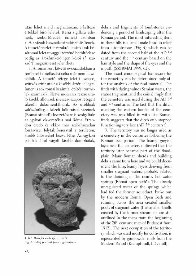
után lehet majd meghatározni, a keltező értékkel bíró leletek (terra sigillata edé-nyek, szobortöredék, érmek) azonban 3.-4. századi használatot valószínűsítenek. A temetőrészletet északról lezáró árok ké-sőrómai leletanyaggal történő betöltődése pedig az árokfunkció igen késői (5. szá-zad?) megszűnését jelentheti. 3. A római kort követő évszázadokban a területet temetkezési célra már nem hasz-nálták. A temető rétege feletti iszapos, szürkés szint utalt a későbbi ártéri jellegre. Innen is sok római kerámia, építési törme-lék származik, illetve mocsaras részre uta-ló kisebb állóvizek meszes-iszapos rétegeit sikerült dokumentálnunk. Az utóbbiak valószínűleg a közeli hőforrások vizeinek (Római strand?) levezetésére is szolgáltak: az egykori vízvezeték a mai Római Stran-don eredő és ekkor már szabályozatlan forrásvízei folytak keresztül a területen, kisebb állóvizeket hozva létre. Az egykori patakok által vágott kisebb dombhátak,
86
4. kép: Reliefes szoborfej sírkőrőlFig. 4: Relief portrait from a gravestone
debris and fragments of tombstones evi-dencing a period of landscaping after the Roman period. The most interesting item in these fi lls is a small male head in relief from a tombstone, (Fig. 4) which can be dated from the second half of the AD 3rd century and the 4th century based on the hair style and the shape of the eyes and the mouth (SZIRMAI 1999, 62). The exact chronological framework for the cemetery can be determined only af-ter the analysis of the fi nd material. The fi nds with dating value (Samian wares, the statue fragment, and the coins) imply that the cemetery was used during the AD 3rd and 4th centuries. The fact that the ditch marking the eastern border of the cem-etery was was fi lled in with late Roman fi nds suggests that the ditch only stopped functioning very late (AD 5th century?). 3. The territory was no longer used as a cemetery in the centuries following the Roman occupation. The loamy, greyish layer over the cemetery indicated that the territory later became part of the fl ood-plain. Many Roman sherds and building debris came from here and we could docu-ment the limy, loamy layers deriving from smaller stagnant waters, probably related to the draining of the nearby hot water springs (Római open bath?). The already unregulated water of the springs which had fed the former aqueduct, broke out by the modern Római Open Bath and running across the area created smaller pools of stagnant water (the smaller knolls created by the former streamlets are still outlined in the maps from the beginning of the 20th century: map of Budapest from 1912). The next occupation of the territo-ry, which was used mostly for cultivation, is represented by gunpowder mills from the Modern Period (Krempl-mill, Illés-mill).
vonulatok még a 20. század eleji térképe-ken is világosan kirajzolódnak: 1912. évi Budapest térkép. Az inkább csak mezőgaz-dasági célú területrészen legközelebb csak az újkorban jelennek meg lőpormalmok (Krempl-malom, Illés-malom). 4. A terület keleti része már a Duna árterülete lehetett, itt sírokat már nem találtunk, és úgy tűnik, ez a rész egészen az újkorig beépítetlen maradt. Egyedül a 18.-19. századra keltezhető (talán) gazda-sági épület pincerésze és omladéka került itt elő, gazdag kerámiaanyaggal és egy malomkővel, tehát egy kőágyba helyezett csatorna részletét dokumentáltuk. A feltárás során regisztrált rétegso-rokból az antik természeti környzetre is következtetni lehetett, amelyre vonatkozó régészeti megfi gyeléseinket Mindszenty Andrea és Horváth Zoltán geológusok terepi vizsgálódásai is alátámasztották. Ezek szerint a temetkezésre használt – és alkalmas – területrész a kiemelkedő ho-mokdomb volt, bokros, ligetszerű növény-zettel. A 19. század első harmadában még szinte ugyanilyen volt itt a terepalakulat. (SAS 1831, 130–131) A sírok periferikus elhelyezkedése antropológiai szempontból is fi gyelemre méltó. Annak ellenére, hogy a temető csontanyaga rossz megtartásúnak mond-ható, sikerült néhány érdekes megfi gyelést tenni. A csontok meghatározását Tankó Éva végezte. Az anyag mosása, konzerválá-sa a csontok rendkívül rossz állapota miatt meglehetősen nehéz volt. A vizsgálható koponyákat csak az iszapos homok tartotta egyben. A vázcsontok nagy része darabok-ra esett, így a mérhető adat meglehetősen kevés. A 31 vizsgált sírból 21 felnőtt és 2 gyermek embertani vizsgálata volt le-hetséges. Kormeghatározást 11 esetben végeztünk, ebből 4 eset bizonytalan.
4. The eastern part of the territory may have been part of the Danube fl oodplain. We found no graves here and the area seems to have remained uninhabited until the Modern Period. Only the cellar fragment and the ruins of a (perhaps) economic out-building from the 18th-19th centuries were discovered here together with a rich ceramic material and a mill-stone as well as the fragment of a channel constructed in a stone bed. The layer sequence uncovered by the excavations revealed the contemporary natural environment as well. Andrea Mindszenty and Zoltán Horváth ge-ologists’ fi eld surveys corroborated our archaeological observations. Accordingly, the territory suitable and used for burials was a sand knoll covered by shrub vegeta-tion standing in groves. The surface relief was nearly the same in the fi rst third of the 19th century (SAS 1831, 130-131). The peripheral position of these graves relative to the Civil Town is interesting from an anthropological point of view as well. Although the bones were poorly preserved in the cemetery, a few very in-teresting observations could still be made. Éva Tankó, identifi ed the bones. The washing and conservation of the bones proved very diffi cult because of the very poor condition they were in. Only the loamy sand held the skulls together. Many of the bones from the skeleton fell into pieces so that very few metric data could be taken. Of the 31 graves, the anthropolo-gist was able to examine 21 adults and 2 children. Age determination was possible in 11 cases of which 4 identifi cations were uncertain. The muscle attachments were well developed on the arms of both men and women, implying that in life these people
87

Férfi aknál, nőknél egyaránt gyakori jelenség karokon az izomtapadási he-lyek fejlettsége, melyek erőteljes fi zikai igénybevételre, megterhelésre utalnak. A 7. sírban talált adultus korú férfi töre-dékes felkarcsontján feltehetően ütéstől származó traumás nyom látható. A 29. sír nőies jellegeket mutató csontvázhoz tartozó töredékes lábszárcsonton ovális alakú, mintegy 5 centiméter hosszúságú csontkinövés fi gyelhető meg. Egy további töredéken periostitis (csonthártyagyul-ladás) nyomai láthatóak. A 35. sírban talált, feltehetően idősebb nő állkapcsát fogmederágy gyulladás roncsolta. A caries (fogszuvasodás) nem jellemző az adott korban. A 19. sírban talált adultus korú egyén esetében fejlődési rendellenesség állapítható meg. Testmagassága a mért adatok alapján 120,6 centiméter, amely a többi vázcsontot fi gyelembe véve arányos törpeséget jelenthet. A feltárás eredményei alapján két lehe-tőség körvonalazódik az újonnan előkerült temetőrészlet topográfi ai helyzetére és szerepére vonatkozóan. Egyfelől elkép-zelhető, hogy a polgárvároshoz tartozóan olyan kisebb, félreeső helyen kialakított, „eldugott”, de folyamatosan használt te-metőparcelláról van szó, ahol egyrészt az alacsonyabb társadalmi helyzetű egyének nyertek végső nyughelyet (kemény fi zikai munkát végző rabszolgák, libertusok?), illetve a társadalomban valamilyen okból hátrányos helyzetben élőket (törpenövé-sű) temették. A másik lehetőség, hogy ez a terü-let – Nagy L. feltételezésének megfele-lően – már valószínűleg a polgárváros keleti temetőjének északi széle volt – erre utalhat a fent említett kelet–nyugati szé-les árok jelenléte is, amelytől északra sírok már nem kerültek elő. A patológiás esetek
88
bore heavily burdens and were over-strained. A traumatic trace probably from a blow can be seen on the fragmentary hu-merus of an adult man in grave no. 7. An oval, about 5 cm long bony growth can be observed on the fragmentary tibia of the skeleton of grave no. 29 showing feminine features. Another fragment shows traces of periostitis. The jaw of a probably older woman in grave no. 35 was damaged by alveolitis. Caries are not characteristic. A disturbance in growth was identifi ed in the case of the adult individual in grave no. 19. Her height, calculated from the measurements, was 120.6 cm. Taken together with the rest of the bones this individual must have suffered from pro-portionate dwarfi sm. Two interpretative possibilities are pre-sented by the results of the excavations relative to the topographical position and role of the recently unearthed fragment of cemetery. One possibility is that it was a smaller, “hidden”, yet continuously used cemetery parcel of the Civil Town where people from the lower social layers were laid to rest (slaves or liberi? people who did hard physical work). The deceased were thus, members of society who were for some reason disadvantaged (such as dwarf) and buried here, a little apart, when they died. The other possibility is that this ter-ritory, as L. Nagy suggested lay at the northern edge of the eastern cemetery of the Civil Town. This is suggested by the above-mentioned wide east–west oriented ditch, north of which there were no more graves. The pathological cases and the presence of people doing hard physical work can be explained by the special func-tion of the edge of cemeteries in Roman times, namely that social cast-offs were

és az egykor nehéz fi zikai munkát végző egyének jelenléte magyarázható a teme-tő szélének olyan funkciójával, hogy oda szintén a társadalomból valamilyen okból „kivetett” személyeket temették. A teme-tőrészlet pontos topográfi ai szerepének meghatározása (önálló temető, vagy az ún. gázgyári temető északi perifériája) csak to-vábbi kutatások során lesz eldönthető.
T. Láng Orsolya
Irodalom/References:
SAS 1831 – Sas I.: Ó-budai határon ujonnan felfedeztetett római régiségek. [Recently discovered antiquities on the border of Óbuda] In: Sas I. (ed.: Thaiss et Csernecz) Pest, 1831NAGY 1942 – Nagy L.: Temetők, temetke-zés. [Cemeteries and burials] In: Budapest az ókorban. Budapest története II. (szerk. Szendy K.) Budapest, 1942RÖMER 2000 – Römer zwischen Alpen und Nordmeer. (Hrsg. L.Wamser.) Mainz, 2000SZILÁGYI 1950 – Szilágyi J.: Jelentés a Fővárosi Ókortörténeti (Aquincumi) Múzeum kutatásairól és szerzeményeiről az 1945–48, évek folyamán. BudRég 15 (1950) 303–331.SZIRMAI 1999 – Szirmai K.: Kaiserzeit-liche Portärits in Aquincum. Katalog der Ausstellung. Budapest, 1999
buried there. The exact topographical role of the cemetery fragment (independent cemetery or the northern periphery of the so-called Gas Factory cemetery) can be de-termined only after further investigations.
Orsolya T. Láng
89
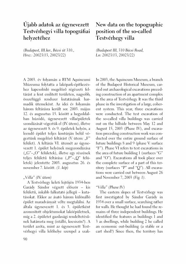
A 2003. év folyamán a BTM Aquincumi Múzeuma folytatta a lakópark-építkezés-hez kapcsolódó megelőző régészeti fel-tárást a fent említett területen, nagyobb, összefüggő rendszer kutatásának har-madik ütemeként. Az idei év folyamán három feltárásra került sor. 2003. május 12. és augusztus 15. között a hegyoldal-ban húzódó, úgynevezett villaépületek szondázását végeztük el (IV. ütem), illetve az úgynevezett 8. és 9. épületek helyén, a leendő épület teljes kontúrján belül vé-geztünk megelőző feltárást (V. ütem: „F” felület). A feltárás VI. ütemét az úgyne-vezett 1. épület helyének megszondázása („G”–„O” felületek), illetve egy részének teljes felületű feltárása („P”–„Q” felü-letek) jelentette 2003. augusztus 26. és november 7. között. (1. kép)
„Villa” (IV. ütem) A Testvérhegy keleti lejtőjén 1934-ben Garády Sándor végzett először – kis felü letű, inkább falkutató jellegű – kuta-tásokat. Ekkor az ásató három különálló épület maradványait vélte megtalálni. Az általa úgynevezett 1. és 3. épületként azonosított objektumokat lakóépületnek, míg a 2. épületet gazdasági rendeltetésű-nek határozta meg (istálló, kocsiszín?). A terület azóta, mint az úgynevezett Test-vérhegyi villa lelőhelye szerepel a szak-
Újabb adatok az úgynevezett Testvérhegyi villa topográfi ai helyzetéhez
(Budapest, III.ker., Bécsi út 310., Hrsz.: 20023/13, 20023/22)
90
In 2003, the Aquincum Museum, a branch of the Budapest Historical Museum, car-ried out archaeological excavations preced-ing construction of an apartment complex in the area of Testvérhegy. It was the third phase in the investigation of a large, coher-ent system. This year, three excavations were conducted. The test excavation of the so-called villa buildings was carried out on the hillside between May 12 and August 15, 2003 (Phase IV), and excava-tion preceding construction work was con-ducted over the entire ground surface of future buildings 8 and 9 (phase V: surface “F”). Phase VI refers to test excavations in the area of future building 1 (surfaces “G” and “O”). Excavations all took place over the complete surface of a part of this ter-ritory (surfaces “P” and “Q”). All excava-tions were carried out between August 26 and November 7, 2003 (Fig. 1).
“Villa” (Phase IV) The eastern slopes of Testvérhegy was fi rst investigated by Sándor Garády in 1934 over a small surface, searching rather for walls. He thought he had found the re-mains of three independent buildings. He identifi ed the features as buildings 1 and 3 as dwellings, while building 2 he called an economic out-building (a stable or a cart shed?) Since then, the territory has
New data on the topographic position of the so-called Testvérhegy villa
(Budapest III, 310 Bécsi Road, Ln: 20023/13, 20023/22)
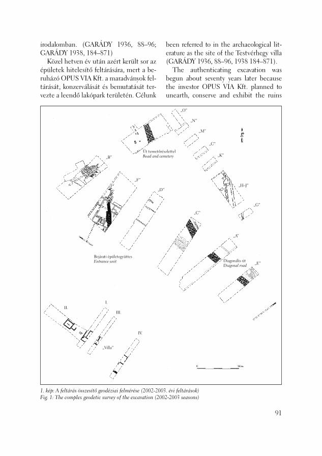
irodalomban. (GARÁDY 1936, 88–96; GA RÁDY 1938, 184–871) Közel hetven év után azért került sor az épületek hitelesítő feltárására, mert a be-ruházó OPUS VIA Kft. a maradványok fel-tárását, konzerválását és bemutatását ter-vezte a leendő lakópark területén. Célunk
1. kép: A feltárás összesítő geodéziai felmérése (2002-200Fig. 1: The complex geodetic survey of the excavation (200
„Villa”
Bejárati épületegyüttesEntrance unit
Út temetőréRoad and ce„B”
„F”
„D
IV.
III.
I.II.
been referred to in the archaeological lit-erature as the site of the Testvérhegy villa (GARÁDY 1936, 88–96, 1938 184–871). The authenticating excavation was begun about seventy years later because the investor OPUS VIA Kft. planned to unearth, conserve and exhibit the ruins
91
3. évi feltárások)2-2003 seasons)
szlettelmetery
”
„C”
„A”
„E”
„G”
„H–J”
„K”
„C”
„M”
„N”
„O”
Diagonális útDiagonal road

2. kép: Az úgynevezett 1. épület részlete nyugat felőlFig. 2: Detail of so-called building 1 from the west
egyelőre csak az épületek pontos helyének (esetleg sarokpontjainak) meghatározása, és nem a teljes felületű feltárás volt, így a kialakított árkokban csak a legfelső római kori szintekig mentünk le, a rétegekbe, omladékokba nem bontottunk bele. Az épületek pontos fekvéséről, geodézi-ai felmérés hiányában nem rendelkeztünk adatokkal, így csak Garády Sándor saját, publikációban szereplő rajzából, illetve a terület jelenlegi alaprajzából lehetett ki-indulni, amelyeket sikerült hozzávetőleges pontossággal összerajzolni. Az így nyert adatok alapján öt szondaárkot jelöltünk ki a hegy lejtőjén. Az I., III., IV. árkokat a hegy lejtőjével párhuzamosan, kelet–nyu-gati irányban húztunk meg, míg a II. árkot erre merőlegesen, észak–déli irányban alakítottuk ki, a lejtő északi részén. Az V. árok, szintén észak–déli irányban, de a lejtő déli részén került kialakításra. Ez utóbbi, néhány rendszert nem mutató természetes kőgörgeteges felületrésztől eltekintve negatív volt. A szondázás során előkerültek a Garády Sándor által már meghatározott épületmaradványok, illetve újabb falak, padlók, útrészletek is, amelyek módosítják az alaprajzi képet, és kérdése-
92
in the territory of the future apartment complex. For the time being, our main intention was to pinpoint the exact loca-tion of these buildings (perhaps their corner points) and not to conduct excava-tions over the entire surface. Thus, we dug down until the highest layer of the Roman period in the trenches and not into the archaeological layers and ruins. Given the absence of data from geo-desical survey work, we did not have information about the exact location of these buildings. We began from Sándor Garády’s drawings which he had pub-lished in his paper as well as the modern plan for the territory, which we could col-late with reasonable exactitude. Five test trenches were opened on the slope after the data we gained from it. Trenches I, III and IV ran parallel to the slope of the hill in an east–west direction, while trench II lay perpendicular to them running in a north–south direction on the northern side of the slope. Trench V also ran from north to south but in the southern part of the slope. This latter one proved empty apart from the surfaces of a few boulders which lacked any systematic patterning.

ket vetnek fel az egyes épületek esetleges összetartozásával kapcsolatban. A Garády Sándor-féle 1. épület terü-letén (I.–III. szondaárkok) a falkoronák, omladékok a mai szint alatt már igen magasan, 50–80 centiméterre kerültek elő. Több ponton megfi gyelhettük Garády Sándor árkainak nyomvonalát is. (2. kép) A jelen kutatás itt az úgynevezett III., IV. és V. helyiségeket érintette, ahol igen jó állapotú terrazzópadló részletét, illetve tetőomladékokat dokumentáltunk. Előke-rültek a már ismert küszöbkövek is, in situ állapotban. A falak szintén jó állapotban maradtak meg, rajtuk még olvashatóak voltak Garády Sándor mérőpontjai is („M”, „O”, „P”). A falak kötőanyaga vál-tozó: agyagos, sóderes, vagy habarcsos volt. Vakolat, festés vagy stukkódíszítés nyomát nem fi gyeltünk meg. A már ismert objektumokon túl új eredménynek számít az úgynevezett III. és IV. helyiségektől nyugatra előkerült, észak–déli irányú falrészlet, amely kidőlt, a hegynyomás miatt deformált állapotban maradt meg, alapozásával és felmenő részével együtt. Észak felé is újabb, ke-let–nyugati irányú falrészlet és küszöbkő bukkant elő, illetve egy falsarok, amelyek talán az épület északnyugati lezárását adják. Az így körvonalazódó új helyiségtől északra pedig olyan, igen rossz állapotú terrazzópadló részleteket találtunk, ame-lyek arra utalnak, hogy az úgynevezett 1. és 2. épület esetleg összefüggő, nagyobb épületkomplexum része lehetett. Szin-tén új információ az I. szondaárok keleti végében előkerült, északkelet–délnyugati irányú kövezés, amely talán az épület felől a főforgalmú, diagonális út felé vezető bel-ső út része lehet. Ez az útrészlet egyúttal valószínűleg jelöli a komplexum keleti szélét is.
The test trenches revealed the building remains found by Sándor Garády as well as more walls, fl oors and road segments. These new data caused modifi cations in the site ground plan and raise questions concerning the possible connections be-tween the individual buildings. The top of the walls and ruins appeared at very high levels, 50–80 cm under the actual ground level in the area of Sándor Garády’s building 1 (test trenches I–III). We could even observe the outlines of Sándor Garády’s trenches (Fig. 2). The actual investigation extended to so-called rooms III, IV and V, where very well preserved fragments of a terrazzo fl oor and the remains of a collapsed roof were documented. We found the previ-ously noted threshold stone as well, in situ. The walls were also well preserved. Even Sándor Garády’s measurement points could still be read on them (“M”, “O” and “P”). The binding matter of the walls was diverse, clayey, gravelly or mortary. We could not observe traces of plaster, paint-ing or stucco ornamentation. Beside the already known features, the north–south oriented wall segment with the foundation and the superstructure unearthed west of the so-called rooms III and IV was a new result. This struc-ture had collapsed and the downward pressure of the hill deformed it. Another east–west oriented wall fragment and a threshold stone appeared in the north as well together with a wall corner, which perhaps outlines the northwest end part of the building. North of this new room, we found very poorly preserved terrazzo fl oor fragments, suggesting that so-called buildings 1 and 2 may perhaps be part of a larger, coherent building complex. The northeast–southwest oriented stone
93

A 2. épület területének I. és II. helyi-ségének falai (II. szonda) szintén kidőlt, deformált állapotban kerültek elő, a hegy eróziója, nyomása miatt. Nagy kiterjedésű tetőomladékokat dokumentáltunk (jó állapotú tegula, imbrex) az úgynevezett II. helyiségben pedig teljes hosszban meg-fi gyelhető elszenesedett fagerendák, ben-nük in situ vasszögekkel, utaltak az egykori tetőszerkezetre. Ez utóbbiakat mintavétel után visszatakartuk. Az úgynevezett 3. épület területén az I., II., III. helyiségeket szondáztuk meg (IV. szonda). A Garády Sándor által már megtalált falakon, in situ küszöbkövön túl itt is tetőomladékokat dokumentáltunk, illetve az egyik, észak–déli irányú, Garády Sándor által is regisztrált fal kötőanya-gaként olyan masszív habarcsos anyagot, illetve felületén opus signinum maradvá-nyait találtuk, amely esetleg vízzel való kapcsolatra utal (medence? ciszterna?). Az épület eddig feltételezett nyugati szélétől nyugatra új, az eddigiektől eltérő struktúrájú, keleti irányban soronként ki-dőlt falvonulat került elő, iránya észak–dél. Az úgynevezett I. helyi ségtől keletre itt is előkerült egy kövezett felületrészlet, talán ez is a belső út része lehet. Két esetben nem találtunk meg olyan falrészleteket, amelyek Garády Sándor rajzán szerepel-nek. A szondázás alapján egyértelműnek látszik, hogy a Garády Sándor által felmért épületeknél nagyobb, más alaprajzú és talán összefüggő komplexummal kell számolni. A feltárás során nem vizsgálhattuk az egyes helyiségek funkcióját, építési periódusa-it, a leletanyag zöme (építési törmelék, állatcsont, római kori házikerámia és né-hány terra sigillata töredék) az omladékok tetejéről, illetve a Garády Sándor által már átforgatott felső talajrétegekből származik.
94
pavement found in the eastern end of test trench I also represents new information. It may be a detail of the interior road that lead from the building to the main, diago-nal road. This road fragment also perhaps marks the eastern edge of the complex. The walls of rooms I and II of build-ing 2 (test trench II) had also collapsed and been deformed by erosion and the pressure of the hill. We documented the remains of a collapsed roof over a large surface (well preserved tegulae, imbrices), while in so-called room II, the charred timbers could be observed in their entire length together with the in situ iron nails in them, the remains of a roof structure. We took samples from these latter and reburied them. Rooms I, II and III were probed in the territory of so-called building 3 (test trench IV). Beside the walls and the in situ threshold stone found by Sándor Garády, we documented collapsed roofs and mas-sive mortary matter, the binding matter of the wall with the remains of opus signinum on its surface, which perhaps indicates that it was in contact with water (a basin? a cistern?). West of the wall previously considered the western wall of the building, we un-earthed a new part of a wall which was fallen out row-by-row, running in a north–south direction. It was built of stone laid in earth, and it ended in an arch at the top. East of so-called room I, another stone-paved surface came to light, perhaps another segment of the interior road. In two cases we could not fi nd wall sections indicated in Sándor Garády’s drawing. The test excavation shows that this com-plex is larger and perhaps more coherent than had been previously thought which had a different ground plan than the

3. kép: A bejárati épületegyüttes feltárás közben déli iránybólFig. 3: The entrance unit seen from the south during excavation
Így az épületek keltezésére, funkciójára érdemi információnk egyelőre nincs. A 2. épület felett, az újkori feltöltésből (vagy eróziós képződményből) két, a későrómai korra keltezhető érem került elő. A most előkerült emlékeket előzete-sen konzerváltuk (különös tekintettel a padlókra) majd téliesítve visszatakartuk (fólia, földréteg).
Az épületegyüttes bejárati része gazdasági épülettel (V. ütem) (3. kép) A hegy lábánál húzódó területen, a „vil-lától” keletre a tavalyi év során már öt na-gyobb felületen („A”–„E”) vizsgáltuk a ró-mai kortól a késő középkorig használt, hét rétegű, diagonális út szerkezetét, illetve egy kerítésfalként értelmezett objektum helyzetét. Így az idei feltárás során ezen fal és a faltól nyugatra húzódó területrész, illetve az észak felől ebben az irányban hú-zódó széles, középkori út újabb részleteit vártuk. (LÁNG 2003, 95–110) A közel 1000 négyzetméter alapterüle-tű felületen („F” felület = 8. és 9. épület) igen sűrű beépítettséget tapasztaltunk,
buildings surveyed by Sándor Garády. We were not able to examine the function and building periods of the individual rooms during the excavation. The majority of the fi nds (building debris, animal bones, household pottery from the Roman period and a few fragments of Samian ware) came from the top of the ruins and the upper soil layers which Sándor Garády had already disturbed. This means that we do not have substantial information on the dating and the function of the buildings. Two coins dated from the late Roman period were re-covered from the modern fi lling (possibly formed by erosion) above building 2. The monuments were preliminar-ily conserved (especially the fl oors) and re-covered with protection for winter (ny-lon and a layer of earth).
The entrance unit of the building complex with the economic out-building (Phase V) (Fig. 3) Last year, we examined the structure of the diagonal road with seven layers, in use from the Roman period to the Late
95
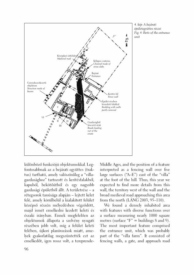
4. kép: A bejárati épületegyüttes részeiFig. 4: Parts of the entrance unit
I
II
III
IV
V
VI
Gerendaszerkezetű objektumStructure made of beams
Gazdaságból kivezető utakRoads leading out of the estate
Kerítés falFence wall
Kőlapos csatornaChannel made of stone slabs
Középkori útfelületMedieval road
BejáratEntrance
Épület részben kiszedett falakkalBuilding with walls partly removed
„F”
különböző funkciójú objektumokkal. Leg-fontosabbnak az a bejárati együttes (trak-tus) tartható, amely valószínűleg a “villa-gazdasághoz” tartozott és kerítésfalakból, kapuból, bekötőútból és egy nagyobb gazdasági épületből állt. A területrész – a rétegsorok tanúsága alapján – lejtett kelet felé, amely körülbelül a kialakított felület középső részén mélyedésben végződött, majd ismét emelkedni kezdett keleti és északi irányban. Ennek megfele lően az objektumok állapota a szelvény nyugati részében jobb volt, míg a felület keleti felében, újkori planírozások miatt, ame-lyek gyakorlatilag megszüntették ezt az emelkedőt, igen rossz volt, a tereprende-
96
Middle Ages, and the position of a feature interpreted as a fencing wall over fi ve large surfaces (“A–E”) east of the “villa” at the foot of the hill. Thus, this year we expected to fi nd more details from this wall, the territory west of the wall and the broad medieval road approaching this area from the north (LÁNG 2003, 95–110). We found a densely inhabited area with features with diverse functions over a surface measuring nearly 1000 square metres (surface “F” = buildings 8 and 9). The most important feature comprised the entrance unit, which was probably part of the “villa farm”. It consisted of fencing walls, a gate, and approach road

5. kép: Miniatűr ezüst fi bula eróziós földrétegbőlFig. 5: Miniature silver brooch from eroded earth
zés szinte „leborotválta” a régészeti ob-jektumokat egykori felületükről. Szintén a rétegsorok tanúsága, hogy a római korban (és a középkorban is) a területre igen gyak-ran érkezhetett eróziós földréteg a hegy irányából, amely vastag feltöltődéseket eredményezett, és amely szükségessé tette az épületek, utak és egyéb létesítmények folyamatos megújítását. (5. kép) A felület nyugati végében kelet–nyu-gati irányítású – valószínűleg gazdasági rendel te tésű – kő épületegyüttes került elő, amelynek keleti helyiségeit sikerült feltárnunk. Az épület tovább húzódott nyugat felé, ez azonban már kívül esett a leendő épület kontúrján, tovább nem követhettük. Az épület hat azonosítható helyiségénél összesen öt építési fázist sikerült elkülönítenünk, amelyeket erózi-ós földrétegek választottak el egymástól. (4. kép) I. A legkorábbi periódust fagerendák lenyomatai jelentik, amelyek részben a felület középső részének mélyszondáiban, részben pedig a kő épület keleti helyiség-sora alatt kerültek elő. Összefüggő alap-rajzot sajnos nem mutatott a konstrukció,
and a larger economic building. The layer sequence showed that this area sloped towards the east, ending in a depression in the central part of the area. From that point the layers sloped upwards towards the east and north. As a consequence, the features were better preserved in the western part of the trench, while in the eastern part of the surface they were very poorly preserved because of modern level-ling work, which, more-or-less, obliterated the slope. The landscaping work quasi “scraped off” the archaeological features from the former land surface. It could also be concluded that eroded earth very often came down the hill building up thick de-posits requiring continuous renovation of the buildings, the roads and other institu-tions (Fig. 4). An east–west oriented stone building complex, probably used in different kinds of economic activities, was discovered in the western end of the excavation surface. Here, its eastern rooms could be brought to light. The building extended further to the west, over into the territory of the future building so that we could not fol-low it. We could distinguish fi ve building phases in the six identifi able rooms of the building, each separated by deposits derived from erosion activity. I. The earliest period is represented by timber imprints, which were partly found in the deep probes in the central part of the surface and partly under the eastern row of rooms from the stone building. The construction did not comprise a coher-ent ground plan, although it seems that the north–south and east–west oriented beams, lying perpendicular to each other, may have belonged to the footing struc-ture of a large timber building (horreum?). Household pottery from the Roman peri-
97

de az irányuk szerint egymásra merőleges, észak–dél és kelet–nyugati irányú ge-rendák talán egy nagyobb gerendavázas épület (horreum?) talpszerkezetéhez tar-tozhattak. A lenyomatok bontásából római kori házikerámia került elő, amelynek kel-tezése csak a leletanyag kiértékelése után válik majd lehetővé. A konstrukció építési és felhagyási időpontja tehát kérdéses, annyi azonban biztos, hogy felszámolása szándékos volt (égés-, vagy pusztításra utaló nyom nem került elő) és közvetlenül ráépültek a későbbi kőépület keleti helyi-ségei. Ia. A fakonstrukciós épülettel talán egy-korú a kőépület általunk legnyugatabbra feltárt, IV. udvarszerű helyiségével, ame-lyet fi gyelembe vett a gerendaszerkezetes épület is. Erre utal, hogy a felületünkkel párhuzamos közműárkokban is előkerült a helyiség déli és északi fala. A nagymé-retű, kőlapokkal burkolt udvar (6. kép) ke-let–nyugati irányú oldalhossza minimum 15 méter. Az udvar burkolata alatt egy kelet–nyugati irányú, mély, teknős kikép-zésű csatorna is feltárásra került, amelyből római kerámia, üveg, faszén, illetve egy bronz veret töredéke származik. Az ud-var közműárokban előkerült déli falának tisztításából több római kori érem jött elő, illetve egy jó megtartású cikkáda fi bula. Az utóbbiak az udvart feltöltő eróziós talajrétegből kerültek elő. II. A következő periódust az a földfel-hordás jelenti, amely nagy valószínűséggel a hegy felől érkező földcsuszamlás ered-ménye, és amely elborította a hegy lábánál húzódó, lejtősebb részt, feltöltve így a kőlapos udvart is (IV. helyiség). III. A következő időszakban az immár sárral feltöltődött udvar szintjét döngölt agyagos járószintként újítják meg, illetve megújítják a falakat is. A réteghez tarto-
98
od was found during the cleaning of these imprints, which can be dated only after the evaluation of the fi nd material. We do not know when the construction was built or abandoned, although it was certainly abandoned intentionally (there was no trace of burning or devastation) and the eastern rooms of the later stone building had been built on top of it (Fig. 4). Ia. The timber building was probably contemporary to courtyard-like room IV from the stone building, the last feature we unearthed in the west, respected when the timber building was constructed. The large courtyard, paved with stone slabs (Fig. 6), was at least 15 long in an east–west direction. This is supported by the fact that the southern and northern walls of the room were found in the trench for the public utilities which ran parallel to our excavation surface. An east–west ori-ented, deep and trough-shaped channel was also uncovered under the pavement of the yard. Roman sherds, glass, charcoal and a fragment of a bronze coin were re-covered from this channel. The cleaning of the southern wall in the public utility trench yielded numerous coins from the Roman period and a well-preserved “ci-cada” brooch. The latter fi nds lay in the eroded deposit that fi lled the courtyard. II. The next period was represented by a soil deposit, most probably a consequence of a earth slide from the hill. It covered the sloping area at the foot of the hill and fi lled in the stone-paved courtyard (room IV). III. In the next phase, the courtyard, which had by then been fi lled in with mud, was renewed as a rammed clay fl oor level and the walls were renovated. The imprints of a square charred wooden frame were found in the room associated

zóan a helyiségben négyszög alaprajzú el-szenesedett fakeret-lenyomatokat regiszt-ráltunk (ipari objektumok?). Innen egy lépcsőfokos átjáró vezetett fel kelet felé, ahol ekkor új, döngölt agyag- és kövezett padlós helyiségeket csatolnak az épület-hez, az egykori gerendakonstrukció helyé-re (I., II.,III., V. helyiségek). A helyiségek funkciója egyelőre nem eldönthető, az I., talán utólag beépített, kövezett szintű helyiségben feltehetőleg valamilyen tűzve-szélyes tevékenységet folytattak. IV. Később, egyelőre pontosan nem da-tálható időszakban ismét a hegy felől ér-kező földréteg borítja el az épületrészeket, amit újabb megújítás követ. V. A megújítás ebben a fázisban a helyiségek (II–V.) ismételt járó-szint-kialakítását jelenti (döngölt agyag-padló), illetve ide tartozik az I. helyiség-ben egy U alakú, átégett, paticsos padka. (7. kép) Ez utóbbi Márton Péter archae-omágneses vizsgálatai szerint – többször, körülbelül 500°C-on átégett, amely így talán kenyérsütő kemence lehetett. A szomszédos helyiségekben szintén meg-fi gyeltünk a horizonthoz tartozóan egyen-
with this layer (industrial features?). From here, a corridor with a step led eastwards, where new rooms with rammed clay and stone paved fl oors were annexed to the building in place of the former timber construction (rooms I, II, III and V). The function of the rooms cannot as yet be de-termined. Perhaps some activity involving a fi re hazard was carried out in the later added paved room I. IV. Later, another soil mass came down the hill and covered the building at an as yet not exactly determined time which was followed by another renovation. V. The renovation included the recon-struction of the fl oor levels (rammed clay fl oor)in this phase. A U-shaped, burnt, daubed bench belongs to this phase in room I (Fig. 7). Based on the archaeo-magnetic analyses carried out by Péter Márton, it burnt repeatedly through at a temperature of 500°C which means that it could perhaps have been a bread-baking oven. In this layer, we could observe evenly levelled debris layers containing charcoal and daub in the neighbouring rooms as well.
99
6. kép: A kőlapos udvar (IV. helyiség) részlete az alatta futó csatornávalFig. 6: Detail of the stone-paved courtyard (room IV) with the channel running beneath it.

7. kép: Átégett, paticsos padka az I. helyiségbenFig. 7: Burnt, daubed bench in room I
letesen elterített, faszenes, paticsdarabos omladékokat. Az ezt követő periódusok már nem voltak rekonstruálhatók, de a felettük húzódó masszív eróziós rétegek alatt az épület lassan „eltűnt”, a középkorban már biztosan nem használták. Az egyes fázisok és a felhagyás pontos időpontját csak a le-letanyag kiértékelése nyomán lehet majd megállapítani. Az épületet dél felől egy délnyu-gat–északkeleti irányú út kerülte ki, amely körülbelül 2 méter széles, négyrétegű, egyenetlen felületű volt, az egyes rétegek megújítására itt is az erózió miatt volt szükség. Funkcióját tekintve valószínűleg hegyoldal felől érkezett, talán a „villa” keleti szélénél regisztrált köves útfelület folytatása (lásd fent, I. szonda). Az út leg-felső rétegének tisztításakor trombitafi bu-la töredéke került elő, de a többi útrétegről is kerültek elő bronz- illetve vasdarabok, római kerámia töredékek. A gazdaságból kivezető út a felület kö zépső részében előkerült észak–déli irányú kerítésfalhoz vezetett, amelynek
100
The subsequent periods could not be reconstructed. The building gradually “disappeared” under the overlying massive erosion layers. It was certainly not used in the Middle Ages. The exact date of the in-dividual phases and the abandonment of the complex can be determined only after evaluation of the fi nd material. A southwest–northeast oriented road curved around the building to its south. It was about 2 m wide with an irregular surface. The road had four layers, which had to be renewed because of continuous erosion. Regarding the function of this road, it probably came from the direction of the hillside. Thus, it may be a continu-ation of the paved road surface noted at the eastern edge of the “villa” (see above, test trench I). A fragment of a ‘trumpet’ brooch was uncovered during the cleaning of the top layer of the road while bronze and iron fragments and Roman sherds were uncovered in the other layers of the road as well. The road that left the farm led to the north–south running fencing wall uncov-
egy szakaszát már tavaly is megtaláltuk („D” felület). Az 50 centiméter széles, kötőanyag nélküli fal alapárka nem volt megfi gyelhető, nagy valószínűséggel az akkori terepszintre épült, erre utal, hogy a fal alja követi az egykori tereplejtést és egy szintben van a legfelső útfelület. A fal szerkezeti érdekessége, hogy kövei közé vízelvezetőként szolgáló imbrexet falaztak be. A talán telekhatárként funkcionáló kerítésfalon nyíló, féloszlopos kapufélfájú bejáratához tartott az út, amelynek hasz-nálaton kívül kerülése után a bejáratot elfalazták. Ez utóbbi nyilván a terület funkcióváltásával is összefüggött. A fal eredeti magasságáról nem sikerült adato-kat nyernünk (omladéka minimális volt). Az elfalazott bejáratba – valószínűleg a későrómai időszakban – lapos kövekből összerótt, fedett kőcsatornát építettek be. Szerepe szerint a hegyoldali épületek felől vezette le a vizet, azok közműve lehetett. Egy kis részlettől eltekintve azonban, az újkori tereprendezések miatt, sem keleti, sem nyugati irányban nem találtuk folyta-tását. Az észak–déli irányú kerítésfalra me-rőlegesen egy másik, az előbbire merő-leges – talán telekhatárként funkcionáló – kelet–nyugati irányú kerítésfalat is doku-mentálhattunk. A fal észak felől határolta le az épületegyüttest, így nem zárható ki, hogy a gazdaság északkeleti sarkát sikerült itt megfognunk. A fal egyúttal a gazda-sági épület északi határfala is volt, talán a tűzveszélyes funkciójú épülettől védte környezetét. A határfal-elméletet az is alá-támasztja, hogy az idei évben tovább bőví-tett „B” felületben (a terület északi része) az észak–déli irányú fő kerítésfal még előkerült, attól nyugatra, a hegyoldal irá-nyába azonban már negatív volt a terület. A szintén kötőanyag nélküli, talajszintre
ered in the central part of the surface, a stretch of which had been found last year (surface “D”). The foundation ditch of the 50 cm thick wall laid in the earth could not be distinguished so that the wall may have been built directly on the ground. This idea is supported by the fact that the bottom of the wall followed the contemporary incline of the surface and lay fl ush with the top layer of the road. A special feature of the wall is that imbrices were inserted between the rocks to carry off water. The road led to the entrance of a single gatepost opening in the fenc-ing wall, which perhaps functioned as an estate boundary. When it was no longer used, the gate was walled in, an event prob-ably linked with a change in the way this territory was used. We could not deter-mine the original height of the wall (there was little debris left from it). Only the top stone row of the wall was still visible in the Middle Ages because of continuous ero-sion, and this stone row was later used for the construction of a road surface. A closed stone channel, constructed of fl at stones, was built into the walled-in entrance, probably in the Late Roman pe-riod. It carried water away from the houses on the hill side so that it may have been part of the local public utilities. Apart from this small section of it, however, we could not fi nd its continuation either in the east or the west due to modern land-scaping activity. Another, east–west oriented fencing wall, perhaps an estate boundary, was documented lying perpendicular to the former north–south running fencing wall. This wall bordered the complex to the north, so we perhaps have found the northeast corner of the farm. The wall was, at the same time, the northern border
101
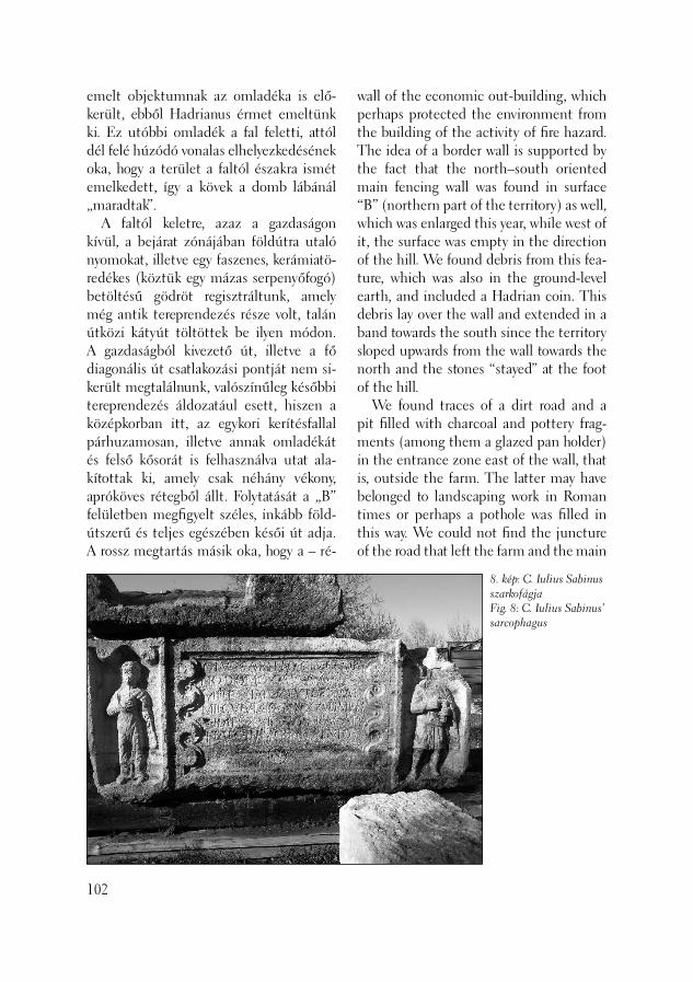
emelt objektumnak az omladéka is elő-került, ebből Hadrianus érmet emeltünk ki. Ez utóbbi omladék a fal feletti, attól dél felé húzódó vonalas elhelyezkedésének oka, hogy a terület a faltól északra ismét emelkedett, így a kövek a domb lábánál „maradtak”. A faltól keletre, azaz a gazdaságon kívül, a bejárat zónájában földútra utaló nyomokat, illetve egy faszenes, kerámiatö-redékes (köztük egy mázas serpenyőfogó) betöltésű gödröt regisztráltunk, amely még antik tereprendezés része volt, talán útközi kátyút töltöttek be ilyen módon. A gazdaságból kivezető út, illetve a fő diagonális út csatlakozási pontját nem si-került megtalálnunk, valószínűleg későbbi tereprendezés áldozatául esett, hiszen a középkorban itt, az egykori kerítésfallal párhuzamosan, illetve annak omladékát és felső kősorát is felhasználva utat ala-kítottak ki, amely csak néhány vékony, apróköves rétegből állt. Folytatását a „B” felületben megfi gyelt széles, inkább föld-útszerű és teljes egészében késői út adja. A rossz megtartás másik oka, hogy a – ré-
102
wall of the economic out-building, which perhaps protected the environment from the building of the activity of fi re hazard. The idea of a border wall is supported by the fact that the north–south oriented main fencing wall was found in surface “B” (northern part of the territory) as well, which was enlarged this year, while west of it, the surface was empty in the direction of the hill. We found debris from this fea-ture, which was also in the ground-level earth, and included a Hadrian coin. This debris lay over the wall and extended in a band towards the south since the territory sloped upwards from the wall towards the north and the stones “stayed” at the foot of the hill. We found traces of a dirt road and a pit fi lled with charcoal and pottery frag-ments (among them a glazed pan holder) in the entrance zone east of the wall, that is, outside the farm. The latter may have belonged to landscaping work in Roman times or perhaps a pothole was fi lled in this way. We could not fi nd the juncture of the road that left the farm and the main
8. kép: C. Iulius Sabinus szarkofágjaFig. 8: C. Iulius Sabinus’ sarcophagus
tegsorok alapján – a terület kelet felé ere-detileg emelkedett, az újkorban azonban nagy mértékű planírozást végeztek itt, így eltüntették a régészeti objektumokat.
Út temetőrészlettel (VI. ütem) A leendő lakópark területének keleti részén még egy épület helyének feltárására került sor (1.épület). Itt, a mai Bécsi úttal párhuzamos területrészen több szonda-árkot húztunk („G–O”), amelyekben egy északkelet–délnyugati irányú, apróköves, rövid ideig használt, mindössze három rétegű útfelület került elő („G–J”), ame-lyet kelet felől sekély árok kísért. Az igen kisszámú leletanyag alapján az útrészlet újkorinak határozható meg (cseréppipa tö-redéke, 18. század). A legészakibb szondák-ban („N–O”) egy igen széles, V alakú árok került elő, amelynek iránya észak–északke-let – dél–délnyugat volt. Iránya és helyzete alapján a római kori diagonális út valamely rétegének vízelvezető árka lehetett. Pontos hovatartozása csak a szintadatok összeveté-se után lesz eldönthető. A terület északkeleti részén megnyitott összefüggő felületen („P–Q”) újabb szaka-sza került elő a diagonális útnak, amely itt már egyértelműen észak felé fordul. A csak átvágásokban vizsgált út hét rétege itt is jól láthatóan „elcsúszott” egymás felett, erőteljesen észak felé tolódva. Az utat nyugati oldalán egy kisebb, hét sírból álló sírcsoport kísérte, amelyek több rétegben kerültek elő. A temetkezések je-lentkezési szintje igen magas volt: néhány esetben 20–50 centiméterre a mai felszín alatt, illetve két esetben az újkori salakos feltöltésben mutatkoztak. Valószínűnek látszik, hogy a római korban magasabban volt a járószint, amelyet azonban az új-korban legyalultak (az „F” felület keleti részének folytatásaként).
diagonal road. It was perhaps destroyed by a later landscaping work since a road com-prised of only a few thin gravel layers was constructed in the Middle Ages parallel to the former fencing wall using its debris and its uppermost stone row. Its continua-tion may be found in the broad, late road observed in excavation surface “B”, which seems to have been a dirt road. Another reason for the poor preservation is that the surface originally sloped upwards in an easterly direction, as it can be seen in the layer sequences, while in the modern period, large-scale landscaping work took place here destroying the archaeological features.
Road with a cemetery fragment (phase VI) The place of yet another building (building 1) was unearthed in the eastern part of the future apartment complex. We opened a number of test trenches in the territory parallel to present-day Bécsi Road (“G–O”), in which a northeast–southwest running road surface was discovered (“G–J”). The road was only used for a short period of time. It comprised only three lay-ers, and its surface was covered with small pieces of rubble. A ditch ran along its eastern side. The very few fi nds date the road segment to the modern period (e.g. a fragment of an 18th century clay pipe,). A very broad, V-shaped ditch was brought to light in the northernmost test trenches (“N–O”), running in a north–northeast – south–southwest direction. Judged from its direction and location, it may have been the drainage channel for one of the layers of the Roman period diagonal road. Its exact affi liation can be clarifi ed only after the layers are correlated. Another stretch of the diagonal road was found on the contiguous excavation
103
A sírokat egy kivételével az úthoz tájol-ták, azaz észak–déli irányításúak, egy eset-ben pedig kelet–nyugati tájolást fi gyeltünk meg. A sírok közül egy hamvasztásos sírt dokumentáltunk, a többi csontvázas rí-tusú volt (6 darab), egy lezárt szarkofágos temetkezéssel. Ez utóbbi, az ábrázolás jellegzetességei miatt a Kr. u. 3. század első harmadára keltezhető sírláda felirata szerint, C. Iulius Sabinus, campaniai il-letőségű, Capuaból származó legionarius (legio II adiutrix) nyughelye volt. (8. kép) A szarkofágot felesége, a cariai(?) szárma-zású Aurelia állította. A feliratos mezőt barokkos, kettős S kereteléssel látták el, két oldalán az elhunyt és felesége egész-alakos ábrázolásával. A szarkofágban két, erősen bolygatott, hiányos vázat találtunk. Háztetőt mintázó teteje – az itt húzódó csővezeték miatt – sérülten került elő. A többi csontvázas sír bolygatatlan volt, keltező értékű kísérő leletanyagaik alap-ján a Kr. u. 3. század közepe – 4. század elejére keltezhetők (III. Gordianus(?), Phlippus Arabs, Hostilianus, Galerius (?) érmei). Két sír között elszórtan előkerült egész edény (Spruchbecher) üveggyöngy és egyéb kerámiaedény töredéke azonban arra utalnak, hogy történhettek sírrablá-sok a területen. Tankó Éva antropológus vizsgálata szerint az igen rossz megtar-tású hat csontvázas sír közül öt felnőtt temetkezése volt, egy pedig gyermekhez tartozott. A területrészen a sírok periódusát megelőzően, északnyugat–délkeleti irá-nyú, háromrétegű apróköves, de inkább földútszerű dűlőút is keresztülvezetett, ennek hovatartozása kérdéses. A temető kialakítása során az utat már biztosan nem használták. A diagonális út nyugati oldalán feltárt jelenségek (temetőrészlet, dűlőút) topo-
104
surface (“P–Q”) opened in the northeast part of the territory. Here, this road obvi-ously turned to the north. The seven layers of the road, studied only in cross-section, evidently veered in a northerly direction. A small grave group of seven graves was situated on the western side of the road. It was uncovered in subsequent layers. The burials appeared very high up in the sequence, sometimes only 20–50 cm un-der the actual ground surface, and in two cases they were spotted in the modern cinder fi ll. The ground surface must have been higher in the Roman period but it was scraped off in the modern period (as the continuation of the eastern part of excavation surface “F”). All the graves, except one, were oriented parallel to the road, that is, in a north–south direction. The exception had an east–west orientation. One of the graves was a cremation burial and the rest were inhumation burials (6 graves). There was one closed sarcophagus burial. The latter can be dated to the fi rst third of the AD 3rd century based on the characteristics of the depictions on it. The inscription on the sarcophagus says that C. Iulius Sabi-nus Campanian, legionary from Capua (legio II adiutrix), lay in the grave (Fig. 8). Aurelia his wife from Caria, had the sar-cophagus made. The inscription fi eld was framed by a Baroque double-S with the full fi gure of the deceased and his wife on the sides. We found two badly disturbed fragmentary skeletons in the sarcopha-gus. The roof-shaped lid was found in a damaged state because of a pipeline that crossed this area. The remainder of the inhumation graves were undisturbed and the fi nds with dat-ing value suggest these people were bur-ied sometime between the middle of the

gráfi ai helyzete nem lehet véletlen. A villa-gazdaság bejárati komplexumával szemben fekvő területről van szó, ahol a gazdaságból kivezető belső útnak rá kellett csatlakoznia a fő, diagonális útvonalra. Így itt kisebb útcsomópontot kell feltételeznünk, amely talán a környék lakóinak temetkezési helye is volt. A 3. század első fele és a 4. század eleje közé keltezhető sírok mindenesetre az Aquincum környéki villagazdaságok prosperáló korszakát idézik.
T. Láng Orsolya
Irodalom/References:
GARÁDY 1936 – Garády S.: Ásatások az óbudai Leopold-téglagyár mellett. [Exca-vations next to the Óbuda brick factory] ArchÉrt 49 (1936) 88–96.GARÁDY 1938 – Garády S.: Az Aquin-cum–Brigetiói római út felkutatása az óbudai Aranyhegyi árok mentén. [Re-search on the Aquincum-Brigetio road along the path of the Óbuda Aranyhegy ditch] Laureae Aquincenes DissPan II, 10 I (1938) 184–187.LÁNG 2003 – Láng O.: Római kori útrész-letek az aquincumi polgárváros municipá-lis territoriumán (az úgynevezett testvér-hegyi villa környezete) [Roman period road segments in the municipal territory of the Aquincum Civil Town (the environs of the so-called Testverhegy villa)] Aqfüz 9 (2003) 95–110.
AD 3rd century and the beginning of the AD 4th century (III Gordianus(?), Philip-pus Arabs and, Hostilianus, Galerius (?) coins). An intact vessel (Spruchbecher), a glass bead and other sherds found scat-tered between two graves imply that some graves must have been violated in this area. According to the antropologist Éva Tankó’s analyses, fi ve of the six very poorly preserved skeletons were from burials of adults while one of the burials was that of an infant. Prior to the period the graves were placed there, a northwest–southeast ori-ented cart road consisting of three layers crossed the territory. It was made from small pieces of rubble and appeared to have been a dirt road. Its affi liation is uncertain but it was certainly no longer in use when the cemetery was established. The topographical situation of the features unearthed on the western side of the diagonal road (cemetery fragment, cart road) cannot be incidental. It is the area facing the entrance to the villa farm where the interior road coming from the farm must have joined the main diagonal road. Perhaps a small road junction was the place the inhabitants of the area bur-ied their dead. The graves, dated from the fi rst half of the AD 3rd century and the be-ginning of the AD 4th century, represent a time when life at the villa farms fl ourished around Aquincum.
Orsolya T. Láng
105
Az építést megelőző feltárást a Glo-tech Kft. megbízásából végeztük. Az első ütemben, 2003. április 14–23. között, az újkori rétegek eltávolítása történt meg, mintegy 1,5 méter mélységig, gépi erővel. Mivel az előzetes tárgyalások elhúzódtak, a második ütemet – a régészeti feltá-rást – csak június 18-án tudtuk megkezde-ni. (1. kép) A 8–10 hónapra tervezett mun-kák mielőbbi befejezése érdekében két műszakos munkavégzésre kényszerültünk október 15. és december 12. között. A beruházó által előrehozott határidő betar-tása így is csak azért volt lehetséges, mert a területen több újkori pince is napvilágra került. Ezek betöltésének gépi eltávolítása meggyorsította a feltárást. A területen a legmélyebb réteg, melyből objektumok indultak, átlagosan 4,5 méter mélységben volt. Egy-egy objektum alja a mai felszín-től nem egyszer 6-7 méterre volt. A terület a középkorban Buda város Szentpétermártír külvárosának peremén helyezkedett el, közvetlenül a Váralját körítő városfal szomszédságában. Magáról a telekről közelebbi információval nem rendelkezünk. A terület a feltárás megkezdésekor üre-sen állt. Korábban a Ganz gyár üzemeinek elhelyezésére szolgált. A telket fedő fel-töltés felső, mintegy másfél métere újkori eredetű volt. Ebbe a feltöltésbe épültek
Feltárások a vízivárosi castellumtól északra
(Budapest, II. ker., Ganz utca 12–14., Hrsz.: 13572/6)
106
Excavations preceding construction work were carried out at the commission of the Glotech Kft. The modern layers were removed mechanically down to a depth of about 1.5 m in the fi rst phase of work (April 14–23, 2003). As the preliminary negotia-tions were protracted, the second phase, the archaeological excavations, could begin only on the 18th of June (Fig. 1). In order to fi nish the operations, planned to last 8–10 month, on time we were compelled to work in two shifts between October 15 and December 12. Even so, the only reason we were able respect the deadline the investor demanded was that a number of modern cellars were discovered in the area. The mechanic removal of their fi ll accelerated the pace of the excavations. The lowest layer, where features fi rst appeared, lay at a depth of 4.5 m on average. The depth of the features ex-tended down to depths of up to 6 or 7 m. The territory was situated at the very edge of the settlement of Szentpétermártír which lay on outskirts of the medieval town of Buda, next to the town wall enclosing the Váralja (castle foot). We had no infor-mation on the lot itself. The territory was vacant at the start of the excavations. Formerly, workshops for the Ganz factory stood here. The upper, circa 1.5 metres of fi ll covering the lot, was deposited in modern times. The founda-
Excavations north of the Víziváros castellum
(Budapest II, 12–14 Ganz Street,Ln: 13572/6)

a Ganz gyári létesítmények (épületfalak, gép alapozások, kemencék), illetve magá-nak a feltöltésnek felső része is néhol a Ganz gyár hulladékát, salakját tartalmaz-ta. Több újkori pince szintén nagyrészt ebbe a feltöltésbe mélyedt, de néhol a mélyebben fekvő rétegeket is megbolygat-ta. Az első pince a Ganz utca 14. keleti szélén, a telekhatár mellett helyezkedett el, a második ugyanennek a teleknek a nyugati szélén hosszan húzódott végig a telek mélységében. A telek hátsó részén, e két pince között egy harmadik, kéthe-lyiséges pincét találtunk. A Ganz utca 12. keleti szélén, a telek középső részén ép boltozatú, igen mély újkori pince került elő. A pincék nagy része a Ganz gyárat megelőző időszakból származik, polgár-házak maradványai. Az említett újkori feltöltés alsó, jelentős része a török kort közvetlenül követő időszakból, a 17-18. század fordulójáról származik. Innen ke-rült elő egy je lentős kályhacsempelelet, feltehetően egy szemétre vetett kályha maradványai. Az újkori feltöltés alján
tions of the Ganz factory were built into this fi ll (walls of buildings, foundations for machines and kilns). At a few spots, the upper part of the fi ll itself contained the debris and the dross from the Ganz factory. Several modern cellars were also dug into this modern fi ll, although these sometimes disturbed the deeper layers as well. The fi rst cellar was found at the eastern edge of lot 14 Ganz Street while the second one extended all along the western edge of the same lot. In the back of the lot, a third cellar with two rooms was found between the two above-mentioned cellars. A very deep modern cellar with an intact dome was found in the central part of the eastern edge of lot 12 on Ganz Street. Most of the cellars were built before the time of the Ganz factoryand had belonged to town houses. The lower, thick part of the mod-ern fi ll came from the turn of the 17th-18th centuries, the period following the Turkish occupation. A signifi cant stove tile fi nd was recovered here, probably from a discarded heating stove. A dark grey, rather homog-
107
1. kép: A feltárás helyszínrajzaFig. 1: Location of the excavations

2. kép: A római kút a famaradványokkalFig. 1: Roman well with wooden remains
sötétbarna, meglehetősen homogén, eny-hén köves, humuszos jellegű talaj borítot-ta be a telket változó vastagsággal. Ez a réteg a geológiai szakvélemények szerint többszörös ártéri kiöntés eredményeként keletkezett, majd jelentős talajosodási folyamaton ment keresztül. Belsejéből rendkívül kevés régészeti leletanyag került elő, a szórványos kerámia anyag a közép-korból származik. A réteg tetejéről számos gazdag leletanyagot őrző, török kori gödör mélyedt a talajba, de török kori építmény nyomát nem találtuk. A telek délkeleti ré-szének jelentős felületét a humuszos talaj alatt hatalmas méretű, szabálytalan alakú és nagyméretű, egymásba ásott gödrök csoportja foglalta el. Ez a gödörfüzér min-den korábbi réteget elpusztított, egészen az altalajig hatolt. A gödrök betöltésében rendkívül kevés leletanyagot találtunk, ám egységesen a 13.-14. század fordulójára keltezhető kerámia jellemezte. A telek déli határa mellett, már túl a gödörfüzé-ren két kút mélyedt az altalajba egymás szomszédságában. Az egyik a török korból származó betöltést tartalmazott (teljesen feltártuk), a másik betöltéséből több állat csontváza (kutya, ló) került elő, középkori kerámia (14.-15. századi) kíséretében. Ezt a megemelkedett talajvíz miatt teljesen ki-ásni nem lehetett. A telek többi részén, a humuszréteg alatt, vékony, római kerámiát is tartalmazó humuszos réteg húzódott. A római rétegek többségét úgy tűnik, hogy a középkorban elplanírozták, és erre terül rá a vastag, humuszos réteg. A római kori topográfi a szerint a telek az 1. századi római tábor feltételezett te-rületétől északra helyezkedik el. Az ásatási területen két bizonytalan rendeltetésű köves felület kivételével római kori járó-szintet nem tudtunk megfi gyelni. Kőfal alapozása csak egy helyen került elő, a
108
enous, slightly stony, humic soil covered the lot in various thicknesses under the mod-ern fi ll. The geological analysis showed this layer was the product of repeated fl oods. The layer later underwent a signifi cant humifi cation process. It contained very few archaeological fi nds, with scattered Medieval sherds. Many pits were dug from the top of this layer in the Turkish period. They contained a rich fi nd material, but we could not fi nd any trace of a construction from the Turkish period. A large surface in the southeastern part of the lot was occu-pied by a vast array of large, irregular pits dug into each other under the humic soil. This series of pits destroyed all the earlier layers down to the virgin soil. Very few fi nds were recovered from the fi ll of the pits, which, however, could uniformly be dated to the turn of the 13th-14th centuries. At the southern border of the lot, beyond the pit series, two wells were sunk side by side into the virgin soil. One contained a fi ll from the Turkish period (entirely unearthed). In the other we found the skeletons of animals (horse and dog) together with medieval sherds (13th-14th centuries). (The high ground water table did not permit us

telek északnyugati részén, annak ellenére, hogy innen nem messze, a Király-fürdőnél, (KABA 1963) illetve a Kacsa utca 7. szám alatti feltáráson (KÉRDŐ–VÉGH 2001) ezek több periódusát is megfi gyelték. Ennek okai az újkori bolygatások, illetve az lehetett, hogy a középkorban a fala-kat teljesen elbontották. Előkerült ezzel szemben több tucat szemét-, illetve táro-lóverem. Ezek egy részében La Tène D és római kerámiát vegyesen találtunk. Lelet-anyaguk feldolgozása a római foglalás és az azt közvetlenül követő időszak krono-lógiájához szolgáltat majd újabb adatokat. Feltártuk több kisebb árok részletét, egyik-ben egy kutya teljes csontvázával. Külö-nösen érdekes lelet volt egy római kút, (2. kép) melynek alja deszkacölöpökkel volt kibélelve. Ezek már sóderes rétegben helyezkedtek el, s a betörő víz miatt nem tudtuk teljes mélységben kibontani. Mivel az építkezés során a kút megsemmisült, a deszkákat kiemeltük. A területen napvilágra került őskori objektumok (késő rézkori, késő bronzkori) feltárását Szilas Gábor irányította.
H. Kérdő Katalin – Végh András
Irodalom/References:
KABA 1963 – Kaba M.: Római kori épület-maradványok a Király-fürdőnél (Römerze-itliche Gebäudereste beim Király-Bad). BudRég 20 (1963) 259–298.KÉRDŐ–VÉGH 2001 – H. Kérdő K. – Végh A.: Budapest, II. ker., Kacsa u. 7 (Budapest, District II, 7 Kacsa Street). Aqfüz 7 (2001) 131–132.
to fi nish its cleaning). In other parts of the lot, a thin humic layer lay under the humus. This contained some Roman ceramics as well. Most of the Roman layers seem to have been levelled in the Middle Ages. This levelling was overlain by the thick humic layer. According to the topography of the Ro-man period, the lot lay north of the sup-posed place of the 1st century Roman fort. Apart from two stony surfaces which had an uncertain function, we were not able to see a fl oor level from the Roman period. Only in one single spot was the foundation of a stone wall found in the northwestern part of the lot. However, layers from various pe-riods had been noted not far from here by the Király baths (KABA 1963) and at the ex-cavation at 7 Kacsa Street (KÉRDŐ–VÉGH 2001). This can be explained by modern disturbances and the fact that the walls had been entirely pulled down in the Middle Ages. At the same time, dozens of refuse and storage pits were uncovered. In some of them La Tène D and Roman sherds were mixed. The analysis of the fi nd material of these pits can contribute to the chronology of the fi rst Roman occupation and the fol-lowing period. Segments of a few smaller trenches were unearthed. In one, there was the complete, articulated skeleton of a dog. A Roman well was an especially in-teresting fi nd. (Fig. 2) Its bottom was lined with plank posts, which, however, could not be cleaned to the entire depth because of ground water. As future construction would destroy the well, the planks were lifted out. Gábor Szilas conducted the excavation on the prehistoric features (late Copper Age, late Bronze Age) discovered in the ter-ritory.
Katalin H. Kérdő – András Végh
109

A 2003. április 29. és szeptember 19. között, nagy felületen végzett ásatás zö-mében a középkorból származó emléket eredményezett. Napvilágra került a Szent István külváros kis részlete és egy török kori temető sírjai. Mivel a Várhegy lábánál található, eredetileg lejtős területet a 18. században lakóházak építése céljára igen
Újabb római kori sírok a vízivárosi ala-tábor déli temetőjéből
(Budapest, I. ker., Szalag utca 22–30., Hrsz.: 14249/4, 14249/5, 14254, 14255, 14256)
110
1. kép: Római kori csontvázas temetkezés (Budapest, I. ker., Szalag utca 30.)Fig. 1: Roman inhumation burial (Budapest I, 30 Szalag St.)
New Roman period graves from the southern cemetery of the Víziváros auxilary fort
(Budapest I, 22–30 Szalag Street, Ln: 14249/4, 14249/5, 14254, 14255, 14256)
Most of the remains unearthed by the excavations conducted over a large surface between April 28 and September 19, 2003 came from the Middle Ages. A small part of the outskirts of St. Steven and graves from a Turkish period cemetery came to light. As the originally sloping territory at the foot of the Castle Hill was heavily scra-ped to produce a horizontal surface in the 18th century for the construction of dwel-lings, a large proportion of earlier archaeo-logical features were destroyed. We found a thick, north–south running medieval wall in lots 26, 28 and 30. This wall pro-bably functioned as a retaining wall based on the analysis of the surface formations. Behind it, medieval refuse layers accumu-lated in a smaller natural depression which yielded a few fi nds of religious character (corpus, fragment of a candlestick). These remains can probably be linked with the nearby Augustine church and monastery named after the protomartyr, St Stephen. András Végh unearthed the cemetery of this monastery in 1997 (VÉGH 1998). We documented a medieval cellar, numerous features from the Turkish period and pre-historic and Roman period features at lot number 30. On the side facing Castle Hill, 160 graves from a Turkish period cemetery were uncovered, all dug into the very thick medieval humus layer. (JB)
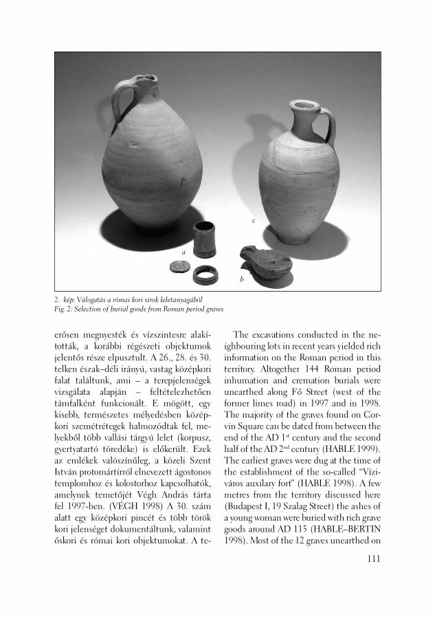
2. kép: Válogatás a római kori sírok leletanyagábólFig. 2: Selection of burial goods from Roman period graves
a
b
c
erősen megnyesték és vízszintesre alakí-tották, a korábbi régészeti objektumok jelentős része elpusztult. A 26., 28. és 30. telken észak–déli irányú, vastag közép kori falat találtunk, ami – a terepjelenségek vizsgálata alapján – feltételezhetően támfalként funkcionált. E mögött, egy kisebb, természetes mélyedésben közép-kori szemétrétegek halmozódtak fel, me-lyekből több vallási tárgyú lelet (korpusz, gyertyatartó töredéke) is előkerült. Ezek az emlékek valószínűleg, a közeli Szent István protomártírról elnevezett ágostonos templomhoz és kolostorhoz kapcsolhatók, amelynek temetőjét Végh András tárta fel 1997-ben. (VÉGH 1998) A 30. szám alatt egy középkori pincét és több török kori jelenséget dokumentáltunk, valamint őskori és római kori objektumokat. A te-
The excavations conducted in the ne-ighbouring lots in recent years yielded rich information on the Roman period in this territory. Altogether 144 Roman period inhumation and cremation burials were unearthed along Fő Street (west of the former limes road) in 1997 and in 1998. The majority of the graves found on Cor-vin Square can be dated from between the end of the AD 1st century and the second half of the AD 2nd century (HABLE 1999). The earliest graves were dug at the time of the establishment of the so-called “Vízi-város auxilary fort” (HABLE 1998). A few metres from the territory discussed here (Budapest I, 19 Szalag Street) the ashes of a young woman were buried with rich grave goods around AD 115 (HABLE–BERTIN 1998). Most of the 12 graves unearthed on
111

3. kép: Válogatás a római kori sírok leletanyagábólFig. 3: Selection of the grave goods from Roman graves
a
b
c
rület Várhegy felőli oldalán igen vastag, középkori humuszrétegbe ásott, török kori temető 160 sírját sikerült kibontanunk. (BJ) A terület római korára vonatkozólag az elmúlt években a környező telkeken végzett feltárások során számos új adatot nyertünk. A Fő utca mentén (az egykori limes-úttól nyugatra), 1997-ben, majd 1998-ban összesen 144 római kori, csont-
112
the northeastern side of Szalag Street in 2003 were disturbed inhumation burials with a north–south orientation. Two we-re new-born babies (neonatus), two were older children (infans II). The grave of a young girl (Fig. 1) yielded light blue, ribbed glass paste beads from beside her right shoulder while a turned bone box lay by her left ankle (2, Fig. 3: a; BÍRÓ 1994). This type of perfume jar (narthe-
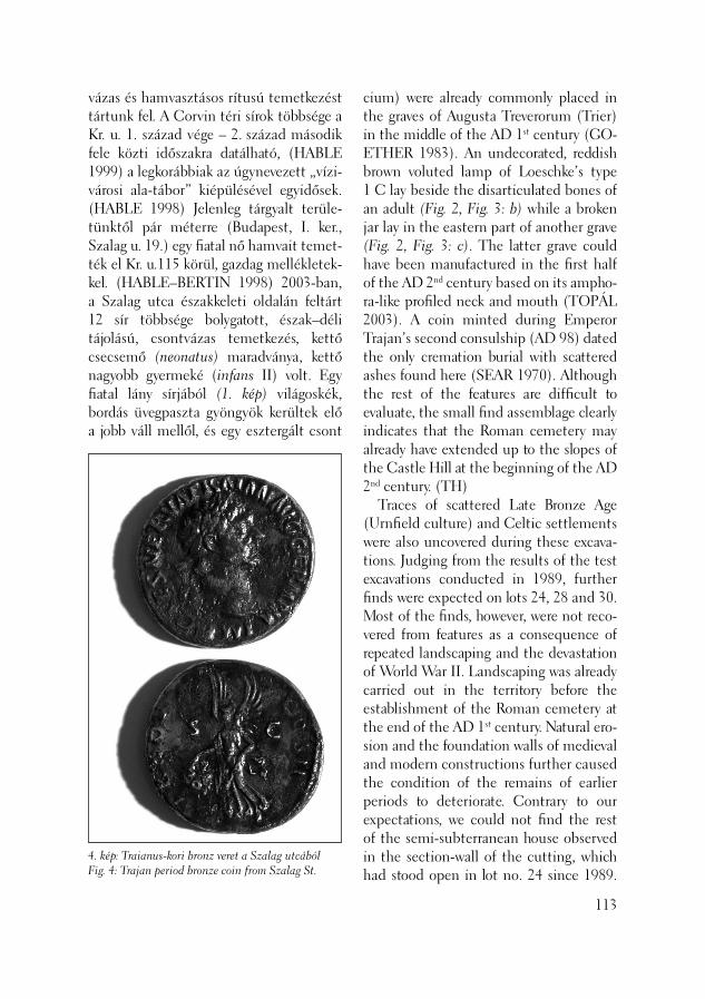
vázas és hamvasztásos rítusú temetkezést tártunk fel. A Corvin téri sírok többsége a Kr. u. 1. század vége – 2. század második fele közti időszakra datálható, (HABLE 1999) a legkorábbiak az úgynevezett „vízi-városi ala-tábor” kiépülésével egyidősek. (HABLE 1998) Jelenleg tárgyalt terüle-tünktől pár méterre (Budapest, I. ker., Szalag u. 19.) egy fi atal nő hamvait temet-ték el Kr. u.115 körül, gazdag mellékletek-kel. (HABLE–BERTIN 1998) 2003-ban, a Szalag utca északkeleti oldalán feltárt 12 sír többsége bolygatott, észak–déli tájolású, csontvázas temetkezés, kettő csecsemő (neonatus) maradványa, kettő nagyobb gyermeké (infans II) volt. Egy fi atal lány sírjából (1. kép) világoskék, bordás üvegpaszta gyöngyök kerültek elő a jobb váll mellől, és egy esztergált csont
4. kép: Traianus-kori bronz veret a Szalag utcábólFig. 4: Trajan period bronze coin from Szalag St.
cium) were already commonly placed in the graves of Augusta Treverorum (Trier) in the middle of the AD 1st century (GO-ETHER 1983). An undecorated, reddish brown voluted lamp of Loeschke’s type 1 C lay beside the disarticulated bones of an adult (Fig. 2, Fig. 3: b) while a broken jar lay in the eastern part of another grave (Fig. 2, Fig. 3: c). The latter grave could have been manufactured in the fi rst half of the AD 2nd century based on its ampho-ra-like profi led neck and mouth (TOPÁL 2003). A coin minted during Emperor Trajan’s second consulship (AD 98) dated the only cremation burial with scattered ashes found here (SEAR 1970). Although the rest of the features are diffi cult to evaluate, the small fi nd assemblage clearly indicates that the Roman cemetery may already have extended up to the slopes of the Castle Hill at the beginning of the AD 2nd century. (TH) Traces of scattered Late Bronze Age (Urnfi eld culture) and Celtic settlements were also uncovered during these excava-tions. Judging from the results of the test excavations conducted in 1989, further fi nds were expected on lots 24, 28 and 30. Most of the fi nds, however, were not reco-vered from features as a consequence of repeated landscaping and the devastation of World War II. Landscaping was already carried out in the territory before the establishment of the Roman cemetery at the end of the AD 1st century. Natural ero-sion and the foundation walls of medieval and modern constructions further caused the condition of the remains of earlier periods to deteriorate. Contrary to our expectations, we could not fi nd the rest of the semi-subterranean house observed in the section-wall of the cutting, which had stood open in lot no. 24 since 1989.
113
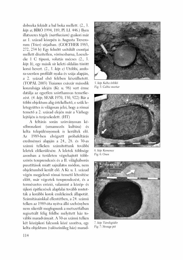
5. kép: Kelta őrlőkőFig. 5: Celtic mortar
6. kép: KemenceFig. 6: Oven
7. kép: TárológödörFig. 7: Storage pit
dobozka feküdt a bal boka mellett. (2., 3. kép: a; BÍRÓ 1994, 189, Pl. LI. 446.) Ilyen illatszeres tégely (narthecium) gyakori már az 1. század közepén is Augusta Trevero-rum (Trier) sírjaiban. (GOETHER 1983, 272, 234 b) Egy felnőtt szétdúlt csontjai mellett díszítetlen, vörösesbarna, Lo esch-cke 1 C típusú, volutás mécses (2., 3. kép: b), egy másik sír keleti oldalán törött korsó hevert. (2., 3. kép: c) Utóbbi, amfo-ra-szerűen profi lált nyaka és szája alapján, a 2. század első felében készülhetett. (TOPÁL 2003) Traianus császár második konzulsága idején (Kr. u. 98) vert érme datálja az egyetlen szórthamvas temetke-zést. (4. kép; SEAR 1970, 130, 922) Bár a többi objektum alig értékelhető, e szűk le-letegyüttes is világosan jelzi, hogy a római temető a 2. század elején már a Várhegy lejtőjén is terjeszkedett. (HT) A feltárás során szórványosan ké-sőbronzkori (urnamezős kultúra) és kelta településnyomok is kerültek elő. Az 1989-ben elvégzett próbafeltárás eredményei alapján a 24., 28. és 30-as számú telkeken számítottunk további leletek előkerülésére. A leletek többsége azonban a területen végrehajtott több-szörös tereprendezés és a II. világháborús pusztítások miatt sajnálatos módon, nem objektumból került elő. A Kr. u. 1. század végén megjelenő római temető létesítése előtt, már végeztek tereprendezést, és a természetes erózió, valamint a közép- és újkori építkezések alapfalai tovább rontot-ták a korábbi korok emlékeinek állapotát. Számításainkkal ellentétben, a 24. számú telken az 1989-óta nyitva álló szelvényben nem sikerült megfognunk a metszetfalban regisztrált félig földbe mélyített ház to-vábbi maradványait. A 30-as számú telken két középkori falcsonk közé szorítva, egy kelta objektum (valószínűleg ház) marad-
114
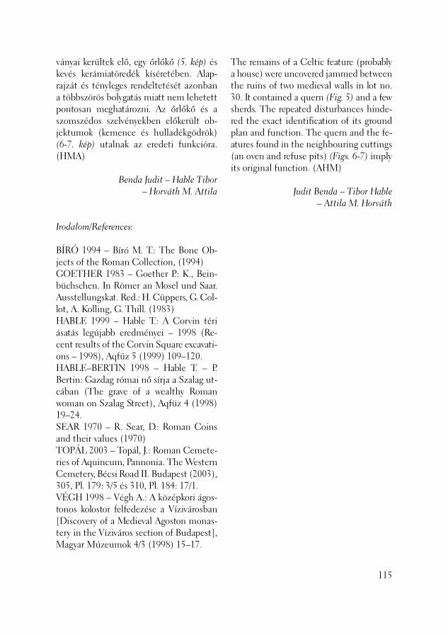
ványai kerültek elő, egy őrlőkő (5. kép) és kevés kerámiatöredék kíséretében. Alap-rajzát és tényleges rendeltetését azonban a többszörös bolygatás miatt nem lehetett pontosan meghatározni. Az őrlőkő és a szomszédos szelvényekben előkerült ob-jektumok (kemence és hulladékgödrök) (6-7. kép) utalnak az eredeti funkcióra. (HMA)
Benda Judit – Hable Tibor – Horváth M. Attila
Irodalom/References:
BÍRÓ 1994 – Bíró M. T.: The Bone Ob-jects of the Roman Collection, (1994)GOETHER 1983 – Goether P.: K., Bein-büchschen. In Römer an Mosel und Saar. Ausstellungskat. Red.: H. Cüppers, G. Col-lot, A. Kolling, G. Thill. (1983)HABLE 1999 – Hable T.: A Corvin téri ásatás legújabb eredményei – 1998 (Re-cent results of the Corvin Square excavati-ons – 1998), Aqfüz 5 (1999) 109–120.HABLE–BERTIN 1998 – Hable T. – P. Bertin: Gazdag római nő sírja a Szalag ut-cában (The grave of a wealthy Roman woman on Szalag Street), Aqfüz 4 (1998) 19–24.SEAR 1970 – R. Sear, D.: Roman Coins and their values (1970)TOPÁL 2003 – Topál, J.: Roman Cemete-ries of Aquincum, Pannonia. The Western Cemetery, Bécsi Road II. Budapest (2003), 305, Pl. 179: 3/5 és 310, Pl. 184: 17/1.VÉGH 1998 – Végh A.: A középkori ágos-tonos kolostor felfedezése a Vízivárosban [Discovery of a Medieval Agoston monas-tery in the Víziváros section of Budapest], Magyar Múzeumok 4/3 (1998) 15–17.
The remains of a Celtic feature (probably a house) were uncovered jammed between the ruins of two medieval walls in lot no. 30. It contained a quern (Fig. 5) and a few sherds. The repeated disturbances hinde-red the exact identifi cation of its ground plan and function. The quern and the fe-atures found in the neighbouring cuttings (an oven and refuse pits) (Figs. 6-7) imply its original function. (AHM)
Judit Benda – Tibor Hable – Attila M. Horváth
115
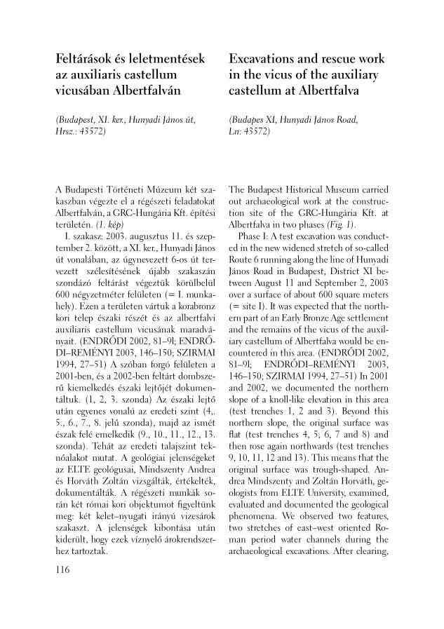
A Budapesti Történeti Múzeum két sza-kaszban végezte el a régészeti feladatokat Albertfalván, a GRC-Hungária Kft. építési területén. (1. kép) I. szakasz: 2003. augusztus 11. és szep-tember 2. között, a XI. ker., Hunyadi János út vonalában, az úgynevezett 6-os út ter-vezett szélesítésének újabb sza kaszán szondázó feltárást végeztük körülbelül 600 négyzetméter felületen (= I. munka-hely). Ezen a területen vártuk a korabronz kori telep északi részét és az albertfalvi auxiliaris castellum vicusának maradvá-nyait. (ENDRŐDI 2002, 81–9l; ENDRŐ-DI–REMÉNYI 2003, 146–150; SZIRMAI 1994, 27–51) A szóban forgó felületen a 2001-ben, és a 2002-ben feltárt dombsze-rű kiemelkedés északi lejtőjét dokumen-táltuk. (1, 2, 3. szonda) Az északi lejtő után egyenes vonalú az eredeti szint (4,. 5., 6., 7., 8. jelű szonda), majd az ismét észak felé emelkedik (9., 10., 11., 12., 13. szonda). Tehát az eredeti talajszint tek-nőalakot mutat. A geológiai jelenségeket az ELTE geológusai, Mindszenty Andrea és Horváth Zoltán vizsgálták, értékelték, dokumentálták. A régészeti munkák so-rán két római kori objektumot fi gyeltünk meg: két kelet–nyugati irányú vizesárok szakaszt. A jelenségek kibontása után kiderült, hogy ezek víznyelő árokrendszer-hez tartoztak.
Feltárások és leletmentések az auxiliaris castellum vicusában Albertfalván
(Budapest, XI. ker., Hunyadi János út, Hrsz.: 43572)
116
Excavations and rescue work in the vicus of the auxiliary castellum at Albertfalva
(Budapes XI, Hunyadi János Road, Ln: 43572)
The Budapest Historical Museum carried out archaeological work at the construc-tion site of the GRC-Hungária Kft. at Albertfalva in two phases (Fig. 1). Phase I: A test excavation was conduct-ed in the new widened stretch of so-called Route 6 running along the line of Hunyadi János Road in Budapest, District XI be-tween August 11 and September 2, 2003 over a surface of about 600 square meters (= site I). It was expected that the north-ern part of an Early Bronze Age settlement and the remains of the vicus of the auxil-iary castellum of Albertfalva would be en-countered in this area. (ENDRŐDI 2002, 81–9l; ENDRŐDI–REMÉNYI 2003, 146–150; SZIRMAI 1994, 27–51) In 2001 and 2002, we documented the northern slope of a knoll-like elevation in this area (test trenches 1, 2 and 3). Beyond this northern slope, the original surface was fl at (test trenches 4, 5, 6, 7 and 8) and then rose again northwards (test trenches 9, 10, 11, 12 and 13). This means that the original surface was trough-shaped. An-drea Mindszenty and Zoltán Horváth, ge-ologists from ELTE University, examined, evaluated and documented the geological phenomena. We observed two features, two stretches of east–west oriented Ro-man period water channels during the archaeological excavations. After clearing,

1. kép: Helyszínrajz a 2003. évi régészeti munkákról AlbertfalvánFig. 1: Ground plan of the 2003 excavations at Albertfalva
1999., 2001. évi ásatásExcavations in 1999 and 2001
Modern beépítésModern building 2003. évi ásatások munkahelyeiSites in 2003
2002. évi ásatásExcavation in 2002
2003. évi ásatásExcavation in 2003
A fenti eredmények alapján megálla-pítottuk, hogy az előző években feltárt korabronz kori telep további, északi ob-jektumai itt már nem jelentkeztek. A 2. századi római kori jelenlétet a vicushoz tartozó víznyelő árokrendszer feltárt szaka-sza igazolja.
we found that they were part of a formal drainage system. We could determine from the above results that no more features from the Early Bronze Age settlement unearthed in the previous years appeared in this more northerly territory. The unearthed frag-
117
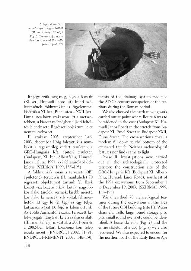
2. kép: Lócsontváz maradványa az egyik kútból
(II. munkahely., 27. obj.)Fig. 2: Remains of a horse
skeleton in one of the wells(site II, feat. 27)
Itt jegyezzük még meg, hogy a 6-os út (XI. ker., Hunyadi János út) keleti szé-lesítésének földmunkáit is fi gyelemmel kísértük a XI. ker., Panel utca – XXII. ker., Duna utca közti szakaszon. Itt a metsze-tekben, a kiásott mélységben újkori feltöl-tés jelentkezett. Régészeti objektum, lelet nem mutatkozott. II. szakasz: 2003. szeptember 1-től 2003. december 19-ig folytattuk a mun-kákat a régészetileg védett területen, a GRC-Hungária Kft. építési területén (Budapest, XI. ker., Albertfalva, Hunyadi János út), az 1994. évi feltárásoktól dél-keletre. (SZIRMAI 1999, 155–195) A földmunkák során a tervezett OBI épületének területén (II. munkahely) 70 régészeti objektumot tártunk fel. Ezek között vízelvezető árkok, kutak, nagyobb kör alakú tárolók, vermek, kisebb méretű kör alakú kemencék, stb. voltak felismer-hetők. Itt egy ló (2. kép) és egy teljes kutyacsontvázat (3. kép) is kibontottunk. Az épülő Auchantól északra tervezett ke-let–nyugati irányú út keleti szakasza alatt (III. munkahely) is vártuk a 2001-ben és a 2002-ben feltárt korabronz kori telep északi részét. (ENDRŐDI 2002, 81–91, ENDRŐDI–REMÉNYI 2003, 146–150)
118
ments of the drainage system evidence the AD 2nd century occupation of the ter-ritory during the Roman period. We also checked the earth moving work carried out at point where Route 6 was to be widened in the east (Budapest XI, Hu-nyadi János Road) in the stretch from Bu-dapest XI, Panel Street to Budapest XXII, Duna Street. The cross-sections reveal a modern fi ll down to the bottom of the excavated trench. Neither archaeological features nor fi nds came to light. Phase II: Investigations were carried out in the archaeologically protected territory, the construction site of the GRC-Hungária Kft (Budapest XI, Albert-falva, Hunyadi János Road), southeast of the 1994 excavations, from September 1 to December 19, 2003. (SZIRMAI 1999, 155–195) We unearthed 70 archaeological fea-tures during the excavations in the area of the future OBI building (site II). Water channels, wells, large round storage pits, pits, small round ovens etc could be iden-tifi ed. A horse skeleton (Fig. 2) and the entire skeleton of a dog (Fig. 3) were also recovered. We also expected to encounter the northern part of the Early Bronze Age
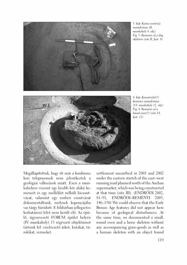
3. kép: Kutya csontváz maradványa (II. munkahely 4. obj.)Fig. 3: Remains of a dog skeleton (site II, feat. 4)
4. kép: Kenyérsütő(?) kemence maradványa (VI. munkahely 12. obj.)Fig. 4: Remains of a bread oven(?) (site VI, feat. 12)
Megállapítottuk, hogy itt már a korabronz kori telepnyomok nem jelentkeztek a geológiai változások miatt. Ezen a mun-kahelyen viszont egy kisebb kör alakú ke-mencét és egy melléklet nélküli lócsont-vázat, valamint egy emberi csontvázat dokumentáltunk, melynek koponyájába vas tárgy fúródott. E földsírban jellegzetes korhatározó lelet nem került elő. Az épü-lő, úgynevezett FORUM épület helyén (IV. munkahely) 13 régészeti objektumot tártunk fel: vízelvezető árkot, kutakat, tá-rolókat, vermeket.
settlement unearthed in 2001 and 2002 under the eastern stretch of the east–west running road planned north of the Auchan supermarket, which was being constructed at that time (site III). (ENDRŐDI 2002, 81–91, ENDRŐDI–REMÉNYI 2003, 146–150) We could observe that the Early Bronze Age features did not appear here because of geological disturbances. At the same time, we documented a small, round oven and a horse skeleton without any accompanying grave-goods as well as a human skeleton with an object found
119
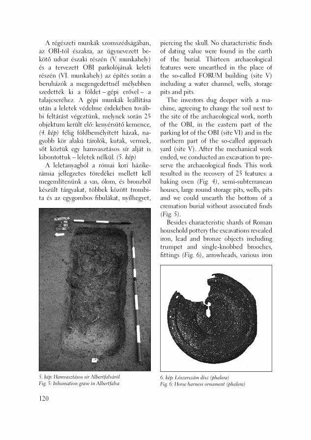
A régészeti munkák szomszédságában, az OBI-tól északra, az úgynevezett be-kötő udvar északi részén (V. munkahely) és a tervezett OBI parkolójának keleti részén (VI. munkahely) az építés során a beruházók a megengedettnél mélyebben szedették ki a földet – gépi erővel – a talajcseréhez. A gépi munkák leállítása után a leletek védelme érdekében továb-bi feltárást végeztünk, melynek során 25 objektum került elő: kenyérsütő kemence, (4. kép) félig földbemélyített házak, na-gyobb kör alakú tárolók, kutak, vermek, sőt köztük egy hamvasztásos sír alját is kibontottuk – leletek nélkül. (5. kép) A leletanyagból a római kori házike-rámia jellegzetes töredékei mellett kell megemlítenünk a vas, ólom, és bronzból készült tárgyakat, többek kö zött trombi-ta és az egygombos fi bulákat, nyílhegyet,
120
5. kép: Hamvasztásos sír AlbertfalvárólFig. 5: Inhumation grave in Albertfalva
piercing the skull. No characteristic fi nds of dating value were found in the earth of the burial. Thirteen archaeological features were unearthed in the place of the so-called FORUM building (site V) including a water channel, wells, storage pits and pits. The investors dug deeper with a ma-chine, agreeing to change the soil next to the site of the archaeological work, north of the OBI, in the eastern part of the parking lot of the OBI (site VI) and in the northern part of the so-called approach yard (site V). After the mechanical work ended, we conducted an excavation to pre-serve the archaeological fi nds. This work resulted in the recovery of 25 features: a baking oven (Fig. 4), semi-subterranean houses, large round storage pits, wells, pits and we could unearth the bottom of a cremation burial without associated fi nds (Fig. 5). Besides characteristic shards of Roman household pottery the excavations revealed iron, lead and bronze objects including trumpet and single-knobbed brooches, fi ttings (Fig. 6), arrowheads, various iron
6. kép: Lószerszám dísz (phalera)Fig. 6: Horse harness ornament (phalera)
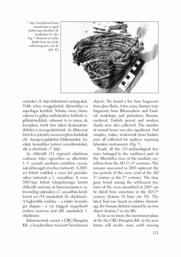
7. kép: Vesszőfonatú kosár maradványa az egyik
kútból vagy tárolóból (II. munkahely 42. obj.)
Fig. 7: Remains of wicker basket from one of the
wells/storage pits (site II, feat. 42)
vereteket, (6. kép) különböző vas tárgyakat. Több ízben üvegpalackok aljtöredékei is napvilágra kerültek. Néhány érem, rhein-zaberni és galliai műhelyekhez köthető si-gillatatöredékek, valamint ős és római, de középkori, török kori újkori kerámiatöre-dékeket is összegyűjtöttünk. Az állatcsont leletek is jelentős mennyiségben fordultak elő. Anyagvizsgálatokra földmintákat, ka-rókat, kosarakhoz tartozó vesszőfonatokat, stb. is eltettünk. (7. kép) Az előkerült 111 régészeti objektum csaknem teljes egészében az albertfalvi 1.-3. századi auxiliaris castellum vicusá-nak délnyugati részéhez tartozott. A 2003. évi feltárt emlékek a vicus két periódu-sához tartoztak a 2. században. A vicus 2003-ban feltárt telepjelenségei között előkerült szórvány sír hamvasztására is va-lószínűleg valamikor a 2. században kerül-hetett sor (VI. munkahely 20. objektum). A legkésőbbi emlékre – a relatív kronoló-gia alapján – a vas tárggyal megsebzett emberi csontváz utal (III. munkahely 1. objektum). Információink szerint a GRC-Hungária Kft. a közeljövőben tervezett beruházásai
objects. We found a few base fragments from glass fl asks. A few coins, Samian ware fragments from Rheinzabern and Gaul-ish workshops and prehistoric, Roman, medieval, Turkish period and modern shards were also collected. The number of animal bones was also signifi cant. Soil samples, stakes, wickerwork from baskets were all collected for analyses requiring laboratory instruments (Fig. 7). Nearly all the 111 archaeological fea-tures belonged to the southwest part of the Albertfalva vicus of the auxiliary cas-tellum from the AD 1st–3rd centuries. The remains uncovered in 2003 represent the two periods of the vicus (end of the AD 1st century in the 2nd century). The stray grave found among the settlement fea-tures of the vicus unearthed in 2003 can be dated from sometime in the AD 2nd century (feature 20 from site VI). The latest fi nd was, based on relative chronol-ogy, the human skeleton injured by an iron object (feature 1 in site III). As far as we know, the investment plans of the the GRC-Hungária Kft. in the near future will involve more earth moving
121

földmunkákkal járnak, melyek további ré-gészeti kutatásokat igényelnek az albertfal-vi vicus területén.
Szirmai Krisztina – Beszédes József
122
Irodalom/References:
ENDRŐDI 2002 – Endrődi A.: Korabronz-kori telepfeltárás Budapest-Albertfalván (The excavation of at Early Bronze Age settlement at Budapest/Albertfalva) Aqfüz 8 (2002) 81–91.ENDRŐDI–REMÉNYI 2003 – Endrődi A. – Reményi L.: Az Albertfalva, 6-os számú főút bővítését megelőző régészeti feltárások eredményei (The results of the excavations preceding the enlargement of route 6 by Albertfalva) Aqfüz 9 (2003) 146–150.SZIRMAI 1994 – Szirmai K.: Új régészeti adatok az albertfalvi vicushoz. 1990-199l [New archaeological Data to the Research of the Albertfalva vicus. 1990-1991] CommArchHung (1994-1995) 27–51. SZIRMAI 1999 – Szirmai K.: Az albertfal-vai vicus, 1994 (Das vicus von Albertfalva, 1994) BudRég 33 (1999) 155–195.
which will necessitate further archaeologi-cal investigations in the area of the Albert-falva vicus.
Krisztina Szirmai – József Beszédes

Az Aquincumi Múzeumba telefonos be-jelentés érkezett 2003. február 4-én, hogy a fenti cím alatt, egy társasház építkezési munkálatai közben latin betűs feliratos követ találtak. Még aznap helyszíni szemlét tettem, melynek során beigazolódott, hogy a dolgozók egy római kori sírkövet találtak, amely a képmező koszorúábrázolása és a dis manibus dedikáció alapján a 2. század első felére keltezhető. A munkások elmondása szerint a kő-emléket az építési törmelékben fedezték fel, ahová vagy az új épület alapozási munkálatai, vagy az attól nyugatra húzott 40 centiméter széles 3,5 méter mély ká-belkutató árok gépi kiásása során kerülhe-tett. A terület tulajdonosa, Denni Matos Gamboa február 19-én adta át az Aquin-cumi Múzeumnak a sírkövet, amely még aznap épségben bekerült a múzeum gyűj-teményébe. A homokkőből készült sírkő 86 centiméter magas, 64 centiméter szé-les és 20 centiméter vastag. (1. kép) Felül vízszintesen záródik, képmezőjében ko-szorút faragtak ki, amelynek alján szalag-dísz, felső részén clipeus látható. A koszo-rúban faragták ki a dis manibus bevezető formula első két betűjét. A képmező két felső sarkában egy-egy koncentrikus kört képeztek ki. A hevenyészetten kifaragott,
Másodlagosan felhasznált római kori sírkő a Herman Ottó utcából
(Budapest, II. ker., Herman Ottó utca 20., Hrsz.: 12027/1)
The Aquincum Museum received a report by telephone on February 4, 2003 that a stone with an inscription in Latin letters had been found at the above address during construction of a block of freehold fl ats. The same day, I surveyed the site and found that the workers had brought to light a tombstone from the Roman pe-riod, dated to the fi rst half of the AD 2nd century based on the wreath in the picture fi eld and the dis manibus dedication. The workers told me that they had discovered the stone monument in the construction debris. It may have been brought there during the digging of the foundation for the new building or the mechanical digging of the 40 cm wide and 3.5 m deep trench for fi nding cables running west of it. Denni Matos Gamboa, the owner of the territory, handed the tombstone over to the Aquincum Museum on February 19. It was placed in the collection of the museum that very day. The sandstone tombstone is 86 cm high, 64 cm wide and 20 cm thick (Fig. 1). At the top it is hori-zontally closed. A wreath was carved in the picture fi eld. At the bottom of this wreath can be seen a ribbon ornament while a clipeus may be seen at the top. The two fi rst letters of the introductory formula dis manibus were carved inside the wreath.
Secondary use of a Roman period tombstone from Herman Ottó Street
(Budapest II, 20 Herman Ottó Street, Ln: 12027/1)
123
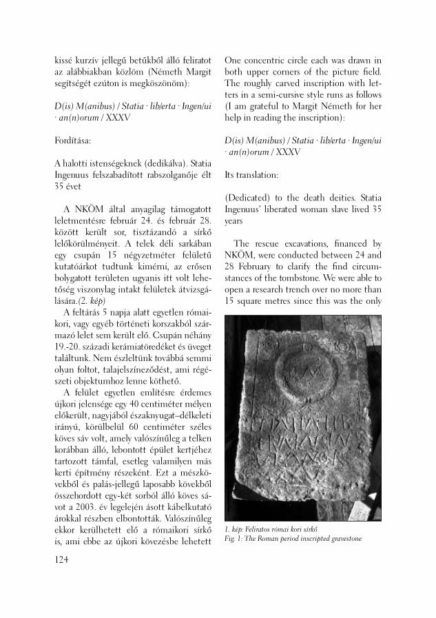
1. kép: Feliratos római kori sírkőFig. 1: The Roman period inscripted gravestone
kissé kurzív jellegű betűkből álló feliratot az alábbiakban közlöm (Németh Margit segítségét ezúton is megköszönöm):
D(is) M(anibus) / Statia · lib/erta · Ingen/ui · an(n)orum / XXXV
Fordítása:
A halotti istenségeknek (dedikálva). Statia Ingenuus felszabadított rabszolganője élt 35 évet
A NKÖM által anyagilag támogatott leletmentésre február 24. és február 28. között került sor, tisztázandó a sírkő lelőkörülményeit. A telek déli sarkában egy csupán 15 négyzetméter felületű kutatóárkot tudtunk kimérni, az erősen bolygatott területen ugyanis itt volt lehe-tőség viszonylag intakt felületek átvizsgá-lására.(2. kép) A feltárás 5 napja alatt egyetlen római-kori, vagy egyéb történeti korszakból szár-mazó lelet sem került elő. Csupán néhány 19.-20. századi kerámiatöredéket és üveget találtunk. Nem észleltünk továbbá semmi olyan foltot, talajelszíneződést, ami régé-szeti objektumhoz lenne köthető. A felület egyetlen említésre érdemes újkori jelensége egy 40 centiméter mélyen előkerült, nagyjából északnyugat–délkeleti irányú, körülbelül 60 centiméter széles köves sáv volt, amely valószínűleg a telken korábban álló, lebontott épület kertjéhez tartozott támfal, esetleg valamilyen más kerti építmény részeként. Ezt a mészkö-vekből és palás-jellegű laposabb kövekből összehordott egy-két sorból álló köves sá-vot a 2003. év legelején ásott kábelkutató árokkal részben elbontották. Valószínűleg ekkor kerülhetett elő a rómaikori sírkő is, ami ebbe az újkori kövezésbe lehetett
124
One concentric circle each was drawn in both upper corners of the picture fi eld. The roughly carved inscription with let-ters in a semi-cursive style runs as follows (I am grateful to Margit Németh for her help in reading the inscription):
D(is) M(anibus) / Statia · lib/erta · Ingen/ui · an(n)orum / XXXV
Its translation:
(Dedicated) to the death deities. Statia Ingenuus’ liberated woman slave lived 35 years
The rescue excavations, fi nanced by NKÖM, were conducted between 24 and 28 February to clarify the fi nd circum-stances of the tombstone. We were able to open a research trench over no more than 15 square metres since this was the only
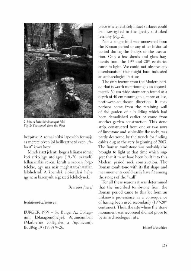
2. kép: A kutatóárok nyugat felőlFig. 2: The trench from the West
beépítve. A római sírkő laposabb formája és mérete révén jól beilleszthető ezen „fa-lazat” kövei közé. Mindez azt jelenti, hogy a feliratos római kori sírkő egy utólagos (19.-20. századi) felhasználás révén, került a szóban forgó telekre, egy ma már meghatározhatatlan lelőhelyről. A kőemlék előkerülési helye így nem bizonyult régészeti lelőhelynek.
Beszédes József
Irodalom/References:
BURGER 1959 – Sz. Burger A.: Collegi-umi kőfaragóműhelyek Aquincumban (Marbreries collégiales a Aquincum), BudRég 19 (1959) 9–26.
place where relatively intact surfaces could be investigated in the greatly disturbed territory (Fig. 2). Not a single fi nd was uncovered from the Roman period or any other historical period during the 5 days of the excava-tion. Only a few sherds and glass frag-ments from the 19th and 20th centuries came to light. We could not observe any discolouration that might have indicated an archaeological feature. The only feature from the Modern peri-od that is worth mentioning is an approxi-mately 60 cm wide stony strip found at a depth of 40 cm running in a, more-or-less, northwest–southeast direction. It may perhaps come from the retaining wall of the garden of a building which had been demolished earlier or come from another garden construction. This stone strip, constructed from one or two rows of limestone and schist-like fl at rocks, was partly destroyed by the trench for fi nding cables dug at the very beginning of 2003. The Roman tombstone was probably also brought to light at that time which sug-gest that it must have been built into this Modern period rock construction. The Roman tombstone with its fl at shape and measurements could easily have fi t among the stones of the “wall”. For all these reasons it was determined that the inscribed tombstone from the Roman period came to this lot from an unknown provenance as a consequence of having been used secondarily (19th-20th centuries). Thus, the site where the stone monument was recovered did not prove to be an archaeological site.
József Beszédes
125
2003 július 14-ét követően tovább folyta-tódott Budapest XXII. kerületében, Nagy-tétényben a Campona erőd kilencedik évadba lépő ásatása és megelőző feltárása. Az idei kutatásokkal egyrészt, hasonló-képpen az elmúlt időszak feltárásaihoz, a régi ásatási eredmények és azok pontos helyszíneinek azonosítása mellett a közel-jövőben kialakítandó Campona-Régészeti Park tervezéséhez szükséges adatokat kívántuk tovább bővíteni, másrészt a hely-színre látogató 19. Nemzetközi Limes-kongresszus résztvevőinek ismét feltártuk és láthatóvá tettük a korábbi évek hitelesí-tő ásatásainak a föld alatt jól megőrződött eredményeit. Az idén tovább folytattuk az erőd ke-leti főkapuja, a porta principalis sinistra körzetében az előző években megkezdett kutatásokat. Újabb adatokat nyertünk a via principalis és az erődfalat belülről követő út, a via sagularis kereszteződésében levő észak–déli csatornáról, a csatorna alatti 1. útrétegről, valamint az út alatti palánk periódusról. A via praetoria, a principia déli oldalá-hoz csatlakozó részén, a korábbi ásatások téliesítésének eltávolítása során újabb adatokat nyertünk a Dunához vezető út későrómai hasznosításhoz. Az Úttörők útján, csatorna építést megelőző feltárás során az erőd nyugati
Nagytétény-CAMPONA 2003
(Budapest, XXII. ker., Úttörők útja 13/a, Hrsz.: 232504)
126
Nagytétény-CAMPONA 2003
(Budapest XXII, Úttörők Street 13/a, Ln:232504)
The ninth season of excavations at the Campona fort got underway at Budapest XXII, Nagytétény on July 14, 2003. The investigations concentrated this year, just as in previous years, on authentication of old excavation results and pinpointing exact fi nd locations, and on obtaining more data for the Campona – Archaeo-logical Park planned for the near future. At the same time, we again uncovered the remains uncovered during the authenti-cating excavations of previous years, excel-lently preserved under the earth, in order to show them to the participants in the 19th International Limes Congress, who visited the site. We carried on investigations started the last year in the region of the porta principalis sinistra, the eastern main gate of the fort. We obtained new data on the north–south oriented channel at the intersection of the via principalis and the via sagularis, which ran along the interior side of the fort wall. We also learned more about road layer 1 lying beneath the chan-nel and the timber period lying under the road. New data emerged after the protecting winter covering had been removed on the Late Roman utilisation of the road leading to the Danube on the via praetoria where it met the southern side of the principia.

127
1. kép: Az erőd alaprajza a munkahelyekkelFig. 1: The ground plan of the fort with the excavation sites
oldaláról és védműveiről, valamint az itt azonosított temetőről kaptunk pontos információkat. S végül, a Duna rendkívül alacsony vízállása lehetővé tette azt, hogy az erőd előterében levő partot, egészen a modern mederkotrás pereméig, híd nyo-mait keresve megvizsgáljuk. Az idei kutatások az 1996-ban létreho-zott, a pontos tájékozódást elősegítendő blokkrendszerünk szerint: az 1. helyszín a V-13-14-15-ös, a 2. helyszín: az M-N-16-os, valamint a 3., a megelőző feltárás helyszíne az A-B-C-D-E-F-9-es blokkok szelvényeibe eső 80 méter hosszú kutatóá-rok. (1. kép) Az 1. helyszínen az 1997 év munkálatait követve (KOCSIS 1998, 84–88; KOCSIS 1999, 124–130; KOCSIS 2000, 93–114; KOCSIS 2001, 105–114; KOCSIS 2002, 105–113) a 2002. év kihagyásával tovább folytattuk a feltárást a V-13 blokk III-IV., a V-14. blokk III. és IV., valamint a V-15-blokk I-II. szelvényeiben a keleti kapu tornyaihoz kapcsolódó területen. Az elmúlt évek során végzett kutatással kimutathatóvá vált, hogy a porta principa-lis sinistra, kétosztatú kapuátjáróval épült meg. (KOCSIS 1998, 84) Azonban a kapu 1970-es évek elején „romkonzervált”, a felszínre felhozott, kibetonozott alaprajza nem felelt meg a hitelesítő ásatások ered-ményeinek. Mivel a kapu északi tornyának a középpillér azonosításában az 1828-ban ide épített pince munkálatai során elbon-tott déli oldala már nem játszhatott szere-pet,(KOCSIS 1998, 84) a még megmaradt déli torony északi oldalfalán levő boltív indító falpillérek maradtak az egyedüli maradványai a két tornyot összekötő, fel-tételezett kapuháznak. A déli torony hátsó frontján, az északnyugati sarkon levő bol-tozat indító falpillér, valamint a kapuházra utaló közép-falpillér hitelesítésére ásott
128
Precise information was obtained about the western side of the fort on Úttörők Road, including its defence works and the cemetery found here during excavation preceding the construction of a channel. Finally, the extremely low water level of the Danube allowed us to investigate the bank in front of the fort up to the edge of the modern dredged basin. Our purpose in looking here was to locate a bridge-head. The following sites were investigated this year based on the grid system set up in 1996 to help in orientation: site 1 in blocks V-13-14-15, site 2 in block M-N-16 and site 3 from the excavation preced-ing construction work was an 80 m long trench in blocks A-B-C-D-E-F-9 (Fig. 1). At site 1 we conducted excavations in 1997 (KOCSIS 1998, 84–88; KOCSIS 1999, 124–130; KOCSIS 2000, 93–114; KOCSIS 2001, 105–113; KOCSIS 2002, 105–113) but did not excavated here in 2002. This year we conducted excavations in trenches III-IV in block V-13, trenches III and IV in block V-14 and in trenches I-II in block V-15 in the territory next to the towers of the eastern gate. The investigations of previous years demonstrated that the porta principalis sinistra was constructed with a double gate passage (KOCSIS 1998, 84). We brought to light the ground plan of the gate, which had been conserved as a ruin by being cast in concrete at the beginning of the 1970’s. However, its form did not match the results of the authenticating excavations. As the southern side of the northern tower of the gate, which had been pulled down at the time of the construction of a cellar in 1828, could not have any role in the identifi cation of the central pillar of the tower (KOCSIS 1998,

2. kép: A déli torony északi falának
alapozása északrólFig. 2: The base of the
northern wall of the southern tower from
the north
szonda a kapu kereszt irányú tengelyében azonban nem a várt eredménnyel zárult. (2. kép) Az északnyugati és a közép-falpillér is teljes mértékben rekonstrukció, amit feltehetőleg 1936-ban a Paulovics féle ásatás lezárásakor vagy a 1970-es években a készítettek a MNM Adattárában fenn-maradt VÁTI (Várostervezési Intézet) tervek alapján. A toronyfal alapozása a felső, nagyméretű kvádersor alatt nagyon rossz megtartású habarcsba, majd alul sárba rakott, amorf kövekből áll. A hátsó fronton levő északnyugati puha mészkő-ből faragott, kis méretű kváderkövekből összerakott falpillér tetejét újkori téglák-kal zárták le, mintegy jelezve, hogy addig „eredeti” a római fal. Azonban a szonda feltárása során kiderült, hogy a kváder-kövek nincsenek bekötve az omlékony toronyfalba sem, valamint, hogy a kváder-kövek alatt fóliát és újkori üveg és kerámia anyagot találtunk. Ugyanezt a jelenséget észleltük a közép-falpillérpillér esetében is. Sajnos a korabeli ásatási beszámolók nem tudósítanak bennünket arról, vajon ez a rekonstrukció egy esetleges falkisze-
84), the only remains of the supposed gatehouse that connected the two towers were the wall pillars found with the start of the vaults in the northern wall of the surviving southern tower. Nevertheless, the test trench opened at the cross-axis of the gate by the back front of the southern tower with the purpose of authenticat-ing central wall pillar and the wall pillar in the northwestern corner where the vault started, suggesting the existence of a gatehouse, led to an unexpected result (Fig. 2). The northwestern and the central wall pillars were pure reconstructions prob-ably carried out at the end of Paulovics’s excavation in 1936 or in the 1970’s based on the VÁTI (Town Development Insti-tute) designs preserved in the Archives of the MNM. The foundation of the tower under the upper row of large ashlars was built of irregular blocks laid in very poorly preserved mortar, and in mud at the bot-tom. The northwestern wall pillar at the back front was built of small ashlars carved from soft limestone. It fi nished at the top by modern bricks, built in to mark the end
129

désen alapszik-e vagy teljes mértékben hipotetikus. A porta praetoria esetében, ahol még nem volt lehetőségünk hitele-sítő ásatás végzésére, a mai felszínen ki-betonozott kétosztatú, kapuházas átjárójú kapu alaprajza jelenik meg előttünk, ahol annak a rendje és módja szerint a tornyok oldalán ott vannak a szükséges falpillérek és a kö zéppillérek is. Hogy ez mennyire hipotetikus, ezt ma még helyszíni kutatás nélkül megítélni nem lehet. A porta praetoria sinistra korábbi hitele-sítő és a jelenlegi ásatások (KOCSIS 2001, 107) eredményeinek birtokában azonban egy új típusú kapu képe vázolható fel, ahol nincs kapuház. A kapuház általában fél toronyszélességű, fedett vagy pártázattal, a kapuátjáró felett kialakított építmény, amire az őrök felmehettek, és ami a két tornyot összekötötte. A mi esetünkben, ennek az építményrésznek hiányában a befelé nyíló kapuszárnyak csak a tornyok hátsó frontján kialakított, két boltíves átjáróval megépített falazat nyílásait zár-hatta le. Ezt az elgondolást támasztja alá egy-részről a hátsó fronton egyedül fennma-radt, viszonylag jó alapozású középpillér megléte, másrészről a kapuzat kereszt-tengelyéből hiányzó középpillér, és az a tény, hogy a kapu előterét a kapuzat ke-reszttengelyéig beérő híddal takart verem védte. (KOCSIS 2002, 105, 1. kép, 108) Számos jel mutat arra, hogy a Duna vidéki auxiliaris erődők kapuzatainál megfi gyelt úgynevezett „patkó alakú” elfalazások egy részénél hasonló megjelenésű kapuház nélküli kapuzattal kell számolnunk. Ez a tény további kérdések megfogalmazásához vezet például a „patkó alakú elfalazás” lét-rejöttének a kora, a szónak a jogosultsága, stb. E problémakör tárgyalása azonban már túlmutat ennek a beszámolónak a
130
of the “original” Roman wall. The test trench revealed, however, that the ashlars were not joined to the ruined wall of the tower, and we found plastic foil and mod-ern glass and pottery material beneath the ashlars. We observed the same phenom-ena by the central wall pillar as well. Re-grettably, contemporary excavation reports do not inform us whether this reconstruc-tion was based on traces of a removed wall or whether it was entirely hypothetical. In the case of the porta praetoria, where we have not yet had the opportunity to conduct authenticating excavations, the ground plan of a double gate with a gatehouse appears cast in concrete on the modern surface, where the necessary wall pillars and central pillars can be found at the sides of the towers, as one would ex-pect them. It cannot be decided without further investigations to what degree they are hypothetical. Nevertheless, a picture of a new gate type without a gatehouse can be drawn from the results of the former authen-ticating and the actual excavations (KOCSIS 2001, 107). The gatehouse was a construction usually built over the passage of the gate. It was half the width of the tower and it was either covered or had a battlement. It connected the two towers and the guards could walk along its length. In our case, due to the absence of this construction unit, the gate wings, which opened inwards, would have closed only the vaulted openings in the wall built at the back front of the towers. This theory is supported, on the one hand, by the existence of the only central pillar that was preserved in relatively good foundation by the back front and, on the other hand, by the missing central pil-lar at the cross-axis of the gate and the

keretein, ezért ez más alkalommal kerül majd megfogalmazásra. A kapuátjáró mögötti terület feltárása során a V-14-III-IV-es szelvényekben az el-múlt években fokozatosan, rétegről-rétegre jutottunk le a via principalis és a via sagu-laris csatlakozási pontján a legalsó útréte-gig. Ez a réteg már az 1999-es ásatás során ismertté vált, amikor a korábbi bolygatások árkait követve és ismét kibontva, az útfel-színt megtaláltuk. (KOCSIS 2000, 96–97., 4. kép) Ekkor az is nyilvánvalóvá vált, hogy az út alatt még további településrétegek várhatók. (KOCSIS 2000, 98, 5. kép) Ebben az évben a 3. réteg bontásával folytattuk a feltárást. A 3-5 centiméter vastag hamus, faszenes réteg alatt bedőlt agyagfal feküdt agyagos, kavicsos járószin-ten, amely azonos volt a korábbi években a V-15-III. szelvényben napvilágra került járószinttel, (KOCSIS 2001, 112) mely-nek egységesnek látszó felületét a közép-pillér nyugati oldalán beásás bolygatta meg. Ez a bolygatás a V-14-IV szelvény „a” szektorában, a középpillér nyugati oldalán egy, a pincével is vágott, ovális, 170×140 centiméter méretű, méhkas alakú gödör, tetején észak–déli sárba rakott falmarad-vánnyal. A középpillér tetejétől mérve 70 centiméterre kemény földes felületet találtunk. Ezt a felületet fogja körbe a gödör szélét követő 30-35 centiméter szé-lességű, amorf köveket tartalmazó falszerű képződmény. A jelenség nagyobb kemen-cére emlékeztet, amelynek észak felől, a pince helyéről lehetett a fűtőnyílása. Ezt az elképzelést erősíti az a tény is, hogy az egész objektum „U” alakú felülnézettel, alul méhkas szerűen kibővülő objektum-ként jelenik meg, betöltésében átégett agyagtömbök, égett kövek, hamu és nagy mennyiségű korom került napvilágra. (3. kép)
fact that the foreground of the gate was protected by a pit covered by a bridge extending to the cross-axis of the gate (KOCSIS 2002, 105, fi g. 1, 108). There is a great deal of evidence that imply that similar gate structures without gatehouses can be expected for some of the “horse-shoe-shaped” walling-ins observed at the gates of the auxiliary forts built along the Danube. This fact leads to more questions such as the date of the “horseshoe-shaped walling-ins”, justifi cation for the term etc. The discussion of this problem, however, is beyond the framework of the present report and will be dealt with at another time. During the course of the excavations in the territory behind the gate, the surface had been gradually deepened, layer by layer, for years until this year when we reached the lowermost road layer at the in-tersection of the via principalis and the via sagularis in trenches V-14-III-IV. This layer was already encountered in 1999 during the tracing and cleaning of trenches from former disturbances. Here, we found the surface of the road (KOCSIS 2000, 96–97, fi g. 4). It also became evident that further settlement layers could be expected be-neath the road (KOCSIS 2000, 98, fi g. 5). This year we continued the cleaning of layer 3. Under a 3-5 cm thick layer of ash and charcoal, a collapsed clay wall lay on the clayey, pebbly fl oor level. This fl oor level was identical with the fl oor level unearthed in previous years in trench V-15-III (KOCSIS 2001, 112). A pit dug on the western side of the central pillar dis-turbed the lowermost, otherwise uniform, surface. This pit, found on the western side of the central pillar in sector “a” of trench V-14-IV, was a 170 × 140 cm, oval, beehive-shaped pit intersected by a cellar.
131
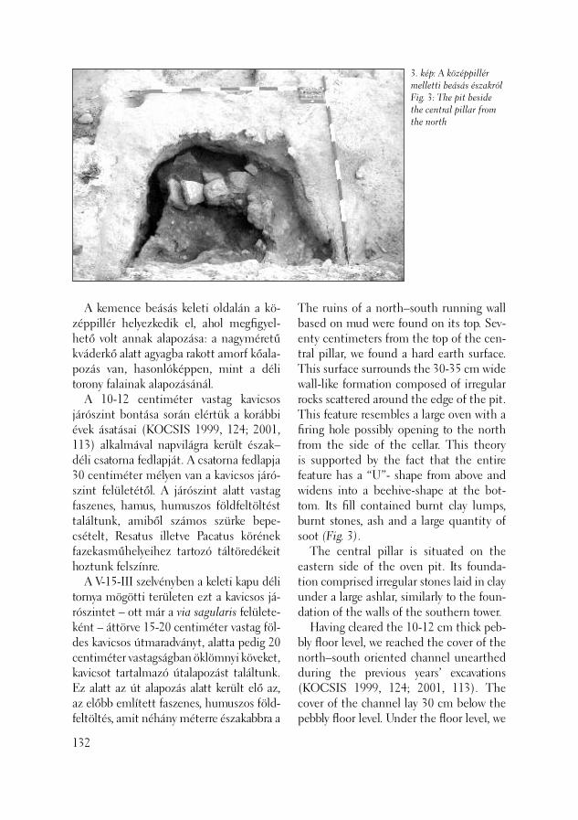
3. kép: A középpillér melletti beásás északrólFig. 3: The pit beside the central pillar from the north
A kemence beásás keleti oldalán a kö-zép pillér helyezkedik el, ahol megfi gyel-hető volt annak alapozása: a nagyméretű kváderkő alatt agyagba rakott amorf kőala-po zás van, hasonlóképpen, mint a déli torony falainak alapozásánál. A 10-12 centiméter vastag kavicsos járószint bontása során elértük a korábbi évek ásatásai (KOCSIS 1999, 124; 2001, 113) alkalmával napvilágra került észak–déli csatorna fedlapját. A csatorna fedlapja 30 centiméter mélyen van a kavicsos járó-szint felületétől. A járószint alatt vastag faszenes, hamus, humuszos földfeltöltést találtunk, amiből számos szürke bepe-csételt, Resatus illetve Pacatus körének fazekasműhelyeihez tartozó táltöredékeit hoztunk felszínre. A V-15-III szelvényben a keleti kapu déli tornya mögötti területen ezt a kavicsos já-rószintet – ott már a via sagularis felülete-ként – áttörve 15-20 centiméter vastag föl-des kavicsos útmaradványt, alatta pedig 20 centiméter vastagságban öklömnyi köveket, kavicsot tartalmazó útalapozást találtunk. Ez alatt az út alapozás alatt került elő az, az előbb említett faszenes, humuszos föld-feltöltés, amit néhány méterre északabbra a
132
The ruins of a north–south running wall based on mud were found on its top. Sev-enty centimeters from the top of the cen-tral pillar, we found a hard earth surface. This surface surrounds the 30-35 cm wide wall-like formation composed of irregular rocks scattered around the edge of the pit. This feature resembles a large oven with a fi ring hole possibly opening to the north from the side of the cellar. This theory is supported by the fact that the entire feature has a “U”- shape from above and widens into a beehive-shape at the bot-tom. Its fi ll contained burnt clay lumps, burnt stones, ash and a large quantity of soot (Fig. 3). The central pillar is situated on the eastern side of the oven pit. Its founda-tion comprised irregular stones laid in clay under a large ashlar, similarly to the foun-dation of the walls of the southern tower. Having cleared the 10-12 cm thick peb-bly fl oor level, we reached the cover of the north–south oriented channel unearthed during the previous years’ excavations (KOCSIS 1999, 124; 2001, 113). The cover of the channel lay 30 cm below the pebbly fl oor level. Under the fl oor level, we

két út – a via sagularis és a via principalis járószintje alatt is megtaláltunk. Ez a humuszos, faszenes földfeltöltés az 1. útfelületen keletkezett réteg volt. A 2. útréteg alatt talált észak–déli csatorna fedlapjára az útréteg kavicsos járószintje ráhúzódik, tehát a csatorna építése meg-előzte a 2. útszint kialakításának az idejét. A csatorna szintje, ami északi irányban, a kapu mögött haladva emelkedik, már vágja az 1. út köves rétegét. Nagy való-színűséggel az 1. útrétegen talált vastag faszenes, humuszos földfeltöltés a vastag faragott kőtömbökből, aljzat nélkül létre-hozott csatorna építését megelőző föld-munka emléke. Az 1. útréteg feltárása alkalmával az út felületéről gazdag kerámiaanyagot, bőr talpmaradványt és vas talpszegecseket tár-tunk fel. Néhány évvel korábban egy régi kutatóárok betöltését követve már ráakad-tunk erre a rétegre. (KOCSIS 2000, 97) Elbontva a 8-12 centiméter vastag kö-ves, kavicsos föld alkotta 1. útréteget, alat-ta a V-14-III. és a IV. szelvényben is 80-120 centiméter átmérőjű kerek beásásokat, illetve azok maradványát találtuk. Betöl-
4. kép: A palánkperiódus oszlopbeásásai
északrólFig. 4: The
postholes from the timber period from
the north
found a thick, humic earth fi ll containing ash and charcoal, from which numerous grey, stamped bowl fragments were re-covered made in the pottery workshops operating under the aegis of Resatus’ and Pacatus’ workshops. We broke though this pebbly fl oor level behind the southern tower of the east-ern gate in trench V-15-III, where it was already the surface of the via sagularis. We found a 15-20 cm thick earthy, pebbly road remaining and, underneath, a 20 cm thick road foundation of fi st-sized stones and pebbles. The above-mentioned humic earth fi ll with charcoal lay under this road foundation. It was also found a few meters to the north, under the fl oor levels of the two roads, the via sagularis and the via principalis. This humic earth fi ll with charcoal was deposited on road surface 1. The pebbly fl oor level of the road layer extended over the cover of the north–south running channel found under road layer 2. It means that the construction of the channel pre-ceded the development of road surface 2. The level of the channel, which slanted
133
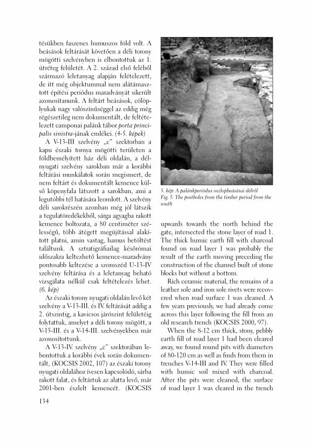
5. kép: A palánkperiódus oszlopbeásásai délrőlFig. 5: The postholes from the timber period from the south
tésükben faszenes humuszos föld volt. A beásások feltárását követően a déli torony mögötti szelvényben is elbontottuk az 1. útréteg felületét. A 2. század első feléből származó leletanyag alapján felételezett, de itt még objektummal nem alátámasz-tott építési periódus maradványát sikerült azonosítanunk. A feltárt beásások, cölöp-lyukak nagy valószínűséggel az eddig még régészetileg nem dokumentált, de feltéte-lezett camponai palánk tábor porta princi-palis sinistra-jának emlékei. (4-5. képek) A V-13-III szelvény „c” szektorban a kapu északi tornya mögötti területen a földbemélyített ház déli oldalán, a dél-nyugati szelvény sarokban már a korábbi feltárási munkálatok során megismert, de nem feltárt és dokumentált kemence kül-ső köpenyfala látszott a sarokban, ami a legutóbbi tél hatására leomlott. A szelvény déli sarokrészén azonban még jól látszik a tegulatöredékekből, sárga agyagba rakott kemence boltozata, a 80 centiméter szé-lességű, több átégett megújítással alakí-tott platni, amin vastag, hamus betöltést találtunk. A sztratigráfi ailag későrómai időszakra keltezhető kemence-maradvány pontosabb keltezése a szomszéd U-13-IV szelvény feltárása és a leletanyag beható vizsgálata nélkül csak feltételezés lehet. (6. kép) Az északi torony nyugati oldalán levő két szelvény a V-13-III. és IV. feltárását addig a 2. útszintig, a kavicsos járószint felületéig folytattuk, amelyet a déli torony mögött, a V-15-III. és a V-14-III. szelvényekben már azonosítottunk. A V-13-IV. szelvény „c” szektorában le-bontottuk a korábbi évek során dokumen-tált, (KOCSIS 2002, 107) az északi torony nyugati oldalához ívesen kapcsolódó, sárba rakott falat, és feltártuk az alatta levő, már 2001-ben észlelt kemencét. (KOCSIS
134
upwards towards the north behind the gate, intersected the stone layer of road 1. The thick humic earth fi ll with charcoal found on road layer 1 was probably the result of the earth moving preceding the construction of the channel built of stone blocks but without a bottom. Rich ceramic material, the remains of a leather sole and iron sole rivets were recov-ered when road surface 1 was cleaned. A few years previously, we had already come across this layer following the fi ll from an old research trench (KOCSIS 2000, 97). When the 8-12 cm thick, stony, pebbly earth fi ll of road layer 1 had been cleared away, we found round pits with diameters of 80-120 cm as well as fi nds from them in trenches V-14-III and IV. They were fi lled with humic soil mixed with charcoal. After the pits were cleaned, the surface of road layer 1 was cleared in the trench
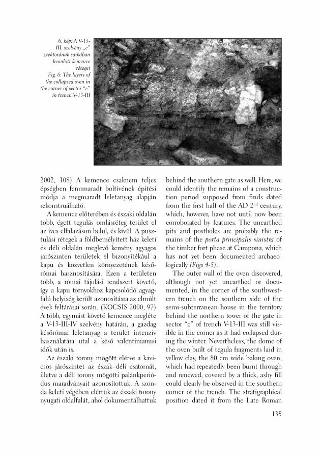
6. kép: A V-13-III. szelvény „c”
szektorának sarkában leomlott kemence
rétegeiFig. 6: The layers of
the collapsed oven in the corner of sector “c”
in trench V-13-III
2002, 108) A kemence csaknem teljes épségben fennmaradt boltívének építési módja a megmaradt leletanyag alapján rekonstruálható. A kemence előterében és északi oldalán több, égett tegulás omlásréteg terület el az íves elfalazáson belül, és kívül. A pusz-tulási rétegek a földbemélyített ház keleti és déli oldalán meglevő kemény agyagos járószinten területek el bizonyítékául a kapu és közvetlen környezetének késő-római hasznosítására. Ezen a területen több, a római tájolási rendszert követő, így a kapu tornyokhoz kapcsolódó agyag-falú helyiség került azonosításra az elmúlt évek feltárásai során. (KOCSIS 2000, 97) A több, egymást követő kemence megléte a V-13-III-IV szelvény határán, a gazdag későrómai leletanyag a terület intenzív használatára utal a késő valentinianusi idők után is. Az északi torony mögött elérve a kavi-csos járószintet az észak–déli csatornát, illetve a déli torony mögötti palánkperió-dus maradványait azonosítottuk. A szon-da keleti végében elértük az északi torony nyugati oldalfalát, ahol dokumentálhattuk
behind the southern gate as well. Here, we could identify the remains of a construc-tion period supposed from fi nds dated from the fi rst half of the AD 2nd century, which, however, have not until now been corroborated by features. The unearthed pits and postholes are probably the re-mains of the porta principalis sinistra of the timber fort phase at Campona, which has not yet been documented archaeo-logically (Figs 4-5). The outer wall of the oven discovered, although not yet unearthed or docu-mented, in the corner of the southwest-ern trench on the southern side of the semi-subterranean house in the territory behind the northern tower of the gate in sector “c” of trench V-13-III was still vis-ible in the corner as it had collapsed dur-ing the winter. Nevertheless, the dome of the oven built of tegula fragments laid in yellow clay, the 80 cm wide baking oven, which had repeatedly been burnt through and renewed, covered by a thick, ashy fi ll could clearly be observed in the southern corner of the trench. The stratigraphical position dated it from the Late Roman
135
a fal szerkezetét. Az alapfalat alkotó nagy-méretű, itt 120 centiméter hosszú, 80 centiméter széles és 40 centiméter vastag kváderkő alatt csak vékony kőporos réte-get azonosíthattunk. A sárba, illetve az agyagba rakott amorf kövekből kirakott alapfalnak itt nem találtuk nyomát, bár a kváderkő alja és az őshumusz felszíne között, a metszet tanúsága szerint még 40 centiméter vastag humuszos föld volt. A kutatóárok északi tanufalában a torony falától 80 centiméterre egy 50 centiméter átmérőjű oszlop beásása helyezkedik el, alján kövekkel. Azonban az oszloplyuk mérete, sem mélysége nem támogatja azt a feltételezést, miszerint ez a palánk periódushoz tartozna. Feltehetőleg a torony építése során használt állványzat egyik oszlopának gödre lehetett. Ezt az elképzelést támasztja alá az a tény, hogy a cölöplyukban kavicsos, kőporos betöltést találtunk. A toronyfaltól mérten 2,4 mé-terre nyugatra megtaláltuk a kapu mögött húzódó észak–déli csatornát, ami dél felé, a Duna irányában lejt. A kutatóárok nyugati végében a V-13-III szelvény „a” szektorában megtaláltuk azt a beásást, illetve annak egy részét, ami erő-sen emlékeztet bennünket a V-14-III és a V-15 I szelvényben talált oszlopbeásásra. Ez is közel 1 méterre mélyed az őshumusz felületébe, mint az előzők közül a nyugati oldalon levők, azonban feltárás nélkül nincs módunkban ebben az esetben mesz-szemenő következtetések levonására. A 2. munkahelyen a korábban újra fel-tárt és hitelesített területen, az 1999. évi téliesítést távolítottuk el. Ennek során az M-16-III. szelvény „a–c” szektorában el-bontottuk a nagy mértékben elgazosodott későrómai szinteket a via praetorián és az út nyugati oldalát szegélyező oszlopbá-zis-sortól nyugatra levő részen.
136
period. A more exact dating of the oven remains must await excavation of the neighboring trench U-13-IV and a de-tailed analysis of the fi nds (Fig. 6). We continued cleaning in trenches V-13-III and IV on the western side of the northern tower down to the surface of the pebbly fl oor level of road level 2, identifi ed in trenches V-15-III and V-14-III behind the southern tower. In sector “c” of trench V-13-IV, we pulled down the mud-based wall joining the western side of the northern tower in an arch, which had been documented in previous years (KOCSIS 2002, 107), and unearthed the oven beneath it, which had already been observed in 2001 (KOCSIS 2002, 108). The construction technology of the oven can be reconstructed from its nearly entirely preserved dome. In the foreground and on the northern side of the oven, a number of debris layers with tegulae extended inside and outside the arched walling-in. The destruction layers lay on the hard clayey fl oor level on the eastern and southern sides of the semi-subterranean house, evidencing the Late Roman use of the gate and its close environs. Here, a number of clay-walled rooms were unearthed in previous years, all following the Roman orientation sys-tem and thus, linking them with the gate towers (KOCSIS 2000, 97). The presence of later ovens and a rich Late Roman fi nd material on the border of trenchs V-13-III-IV demonstrate the intensive use of the territory even after the late Valentinian period. Having reached the pebbly fl oor level behind the northern tower, we identifi ed the north–south running channel and the remains of the timber period behind the
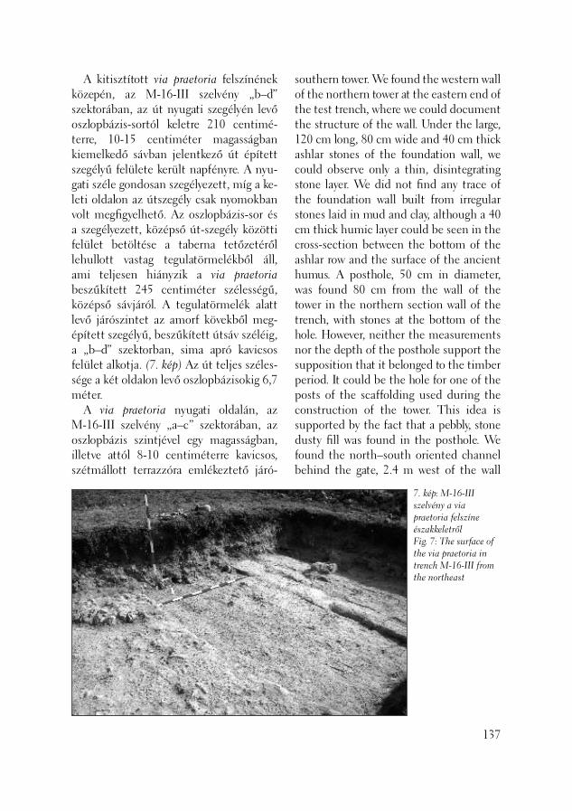
A kitisztított via praetoria felszínének közepén, az M-16-III szelvény „b–d” szektorában, az út nyugati szegélyén levő oszlopbázis-sortól keletre 210 centimé-terre, 10-15 centiméter magasságban kiemelkedő sávban jelentkező út épített szegélyű felülete került napfényre. A nyu-gati széle gondosan szegélyezett, míg a ke-leti oldalon az útszegély csak nyomokban volt megfi gyelhető. Az oszlopbázis-sor és a szegélyezett, középső út-szegély közötti felület betöltése a taberna tetőzetéről lehullott vastag tegulatörmelékből áll, ami teljesen hiányzik a via praetoria beszűkített 245 centiméter szélességű, kö zépső sávjáról. A tegulatörmelék alatt levő járószintet az amorf kövekből meg-épített szegélyű, beszűkített útsáv széléig, a „b–d” szektorban, sima apró kavicsos felület alkotja. (7. kép) Az út teljes széles-sége a két oldalon levő oszlopbázisokig 6,7 méter. A via praetoria nyugati oldalán, az M-16-III szelvény „a–c” szektorában, az oszlopbázis szintjével egy magasságban, illetve attól 8-10 centiméterre kavicsos, szétmállott terrazzóra emlékeztető járó-
southern tower. We found the western wall of the northern tower at the eastern end of the test trench, where we could document the structure of the wall. Under the large, 120 cm long, 80 cm wide and 40 cm thick ashlar stones of the foundation wall, we could observe only a thin, disintegrating stone layer. We did not fi nd any trace of the foundation wall built from irregular stones laid in mud and clay, although a 40 cm thick humic layer could be seen in the cross-section between the bottom of the ashlar row and the surface of the ancient humus. A posthole, 50 cm in diameter, was found 80 cm from the wall of the tower in the northern section wall of the trench, with stones at the bottom of the hole. However, neither the measurements nor the depth of the posthole support the supposition that it belonged to the timber period. It could be the hole for one of the posts of the scaffolding used during the construction of the tower. This idea is supported by the fact that a pebbly, stone dusty fi ll was found in the posthole. We found the north–south oriented channel behind the gate, 2.4 m west of the wall
137
7. kép: M-16-III szelvény a via praetoria felszíne északkeletrőlFig. 7: The surface of the via praetoria in trench M-16-III from the northeast

szintet tártunk fel a későrómai tegula-töredékes épülettörmelék alatt. Ezen a szinten több rétegben agyagos padlómeg-újítások voltak. A „c” szektor közepén, az oszlopbázisokkal párhuzamosan futó, sárba rakott 40 centiméter széles kőfalat találtunk, ami az „a–c” szektor határán futó, kelet–nyugati, szintén 40 centiméter szélességű sárba rakott kőfalba kötött. Általánosságban elmondható, hogy a korábbi évek során napvilágra került 4 oszlopbázis két keleti oldali darabja jobb állapotban maradt fenn, mint a két nyugati oldali, ahol a kő-kváder felületén még kocsikerék koptatta mély sávokat is megfi gyelhettünk. Az előkerült szegélye-zett útfelszín a jelenlegi terepszinttől 90 centiméterre, míg a két oldalán húzódó fi nom kavicsos sáv 100-104 centiméterre helyezkedik el. A via praetoria keleti oldalán, az M-16-II szelvény „b” szektorában ásott szon-dánkban a principia irányában a taberna soron következő oszlop alapozását keres-tük. A szondában az oszlopalapozásként várt kváderkő helyén beásást találtunk, amelyben becsúszva egy kisebb méretű kváderkő volt. A kváderkő mellett az út rétegeibe süllyedve pedig egy oszloptörzs töredékét tártuk fel. A 3. munkahelyünk a camponai ala tábor retentura részén volt, a mai Úttörők útja vonalában, ahol a Budapest XXII ker. Városüzemeltetési KHT egy csatornát kí-vánt építtetni. E beruházást megelőzően, a kijelölt nyomvonalon, megelőző feltárást végezhettünk. A 80 méter hosszú, római rétegeket érintő árok 1,5 méter szélességű, a feltört útburkolat engedte szabályosság-gal készült. Az árokban korábbi ismerete-ink alapján (KOCSIS 2003, 155–161) az erőd teljes nyugati védmű rendszeréről vártunk adatokat. A feltárás során újabb
138
of the tower, which sloped southwards towards the Danube. In sector “a” of trench V-13-III in the western end of the trench we found a pit, or at least a part of it, which was strongly reminiscent of the posthole found in trenches V-14-III and V-15-I. It was also dug into the ancient humus down to a depth of 1 m, similarly to the westerly ones among postholes formerly uncovered. Nevertheless, we cannot draw conclusions without further excavation work. We removed the winter covering pre-pared in 1999 at site 2, an area unearthed and authenticated earlier., We cleared the Late Roman layers in sectors “a–c” of trench M-16-III, overgrown by vegetation, by the via praetoria and in the territory west of the row of column bases fl anking the western side of the road. In the middle of the cleaned surface of the via praetoria in sectors “b-d” of trench M-16-III, 210 cm east of the row of column bases on the western border of the road, we uncovered the surface of the constructed road curb appearing as a strip sticking up to a height of 10-15 cm. The curb was carefully constructed on the western side of the road, while on the eastern side, only traces of it could be observed. The fi ll in the territory between the row of column bases and the curbed central curb consists of thick tegula debris fallen down from the roof of the taberna. This debris is entirely missing from the narrowed, 245 cm wide central lane of the via praetoria. The fl oor level under the tegula debris comprised a fl at surface of small pebbles down to the narrowed road lane with its curb made of irregular stones in sectors “b-d” (Fig. 7). The entire width of the road between the column bases on the two sides measured 6.7 m.
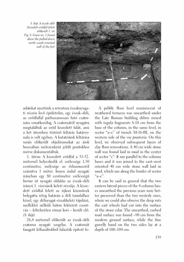
8. kép: A észak–déli kiszedett erődfal felett
előkerült 1. sírFig. 8: Grave no. 1 found
above the pulled-down north–south oriented
wall of the fort
adatokat nyertünk a retentura északnyuga-ti részén levő épületekre, egy észak–déli, az erődfallal párhuzamosan futó csator-nára vonatkozólag. A csatornától nyugatra megtaláltuk az erőd kiszedett falát, ami a két ütemben történő feltárás határvo-nala is volt egyben. A kutatóárok feltárása során előkerült objektumokat az árok hosszában méterenként jelölt pontokhoz mérve dokumentáltuk. 1. ütem: A kiszedett erődfal a 31-32. méternél helyezkedik el. szélessége 1,50 centiméter, mélysége az őshumusztól számítva 1 méter. Innen indul nyugati irányban egy 80 centiméter szélességű berma út nyugati oldalán az észak–déli irányú 1. vizesárok keleti rézsűje. A ki sze-dett erődfal felett az újkori közművek bolygatta réteg határán a déli tanufalhoz közel, egy délnyugat–északkeleti tájolású, melléklet nélküli háton fektetett csont-váz – feltehetően római kori – került elő. (8. kép) 26,4 méternél előkerült az észak–déli csatorna nyugati szegélye. A csatornát faragott kőhasábokból falazták épített fe-
A pebbly fl oor level reminiscent of weathered terrazzo was unearthed under the Late Roman building debris mixed with tegula fragments 8-10 cm from the base of the column, in the same level, in sector “a–c” of trench M-16-III, on the western side of the via praetoria. On this level, we observed subsequent layers of clay fl oor renovations. A 40 cm wide stone wall was found laid in mud in the center of sector “c”. It ran parallel to the column bases and it was joined to the east–west oriented 40 cm wide stone wall laid in mud, which ran along the border of sector “a–c”. It can be said in general that the two eastern lateral pieces of the 4 column bas-es unearthed the previous years were bet-ter preserved than the two westerly ones, where we could also observe the deep ruts the cart wheels had cut into the surface of the stone eslar. The unearthed, curbed road surface was found –90 cm from the modern ground surface, while the fi ne gravelly band on the two sides lay at a depth of 100–104 cm.
139
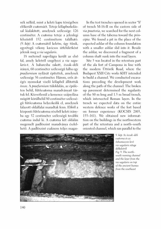
nék nélkül, mint a keleti kapu térségében előkerült csatornáét. Teteje kőlapburkolás-sal kialakított, amelynek szélessége: 126 centiméter. A csatorna teteje a jelenlegi felszíntől 152 centiméterre található. (9. kép) A csatornától keletre, úgy tűnik, egyrétegű vékony kavicsos útfelületként jelenik meg a via sagularis. 18 méternél napvilágra került az első fal, amely keletről szegélyezi a via sagu-laris-t. A habarcsba rakott, észak–déli irányú, 60 centiméter szélességű falba egy praefurnium nyílását építettek, amelynek szélessége 56 centiméter. Három, erős át-égés nyomokat viselő kőlapból állították össze. A praefurnium túloldalán, az épüle-ten belül, fűtőcsatorna maradványait tár-tuk fel. Közvetlenül a kemence szájnyílása mögött körülbelül 80 centiméter szélessé-gű fűtőcsatorna helyezkedik el, amelynek falazott oldalfalai maradtak fenn. Ebből a központi fűtőcsatorna részből keleti irány-ba egy 52 centiméter szélességű további csatorna indul ki. A csatorna két oldalán megemelt padlószint maradványa észlel-hető. A padlószint csaknem teljes magas-
140
In the test trenches opened in sector “b” of trench M-16-II on the eastern side of via praetoria, we searched for the next col-umn base of the taberna toward the prin-cipia. We found a pit in the place of the expected ashlar of the column foundation with a smaller ashlar slid into it. Beside the ashlar, we discovered a fragment of a column shaft sunk into the road layers. Site 3 was located in the retentura part of the ala fort of Campona in line with the modern Úttörők Road, where the Budapest XXII City works KHT intended to build a channel. We conducted excava-tions preceding the development work along the path of the channel. The broken up pavement determined the regularity of the 80 m long and 1.5 m broad trench, which intersected Roman layers. In the trench we expected data on the entire western defence works of the fort based on former experience (KOCSIS 2003, 155–161). We obtained new informat-tion on the buildings in the northwestern part of the retentura and a north–south oriented channel, which ran parallel to the
9. kép: Az észak–déli csatorna és az őshumuszon levő via sagularis rétege délkeletrőlFig. 9: The north–south running channel and the layer from the via sagularis on top of the ancient humus from the southeast
10. kép: Az 1. vizesárok kibontva, bal oldalt a kiszedett erődfal
északnyugatrólFig. 10: The cleaned water channel no. 1
and the pulled-down wall of the fort from the
northwest on the left
ságára az északi tanufalban fennmaradt amorf kövekből agyagba rakott osztófal magassága nyújthat támpontot. A déli oldalon még mindig látható a padlófűtő csatorna szegélyköve. 13 méternél napvilágra került a prae-furniumos fal párja. Rosszabb megtartású fal, mint az előző. A falszövet felázott állaga miatt nem tisztázható, úgy tűnik, mintha sárba rakott falról lenne szó. A fal túloldalán sárga agyagtéglák kerültek elő, amelyeket sötétszínű, humuszos sárral ra-gasztottak egykoron egybe. A téglák mére-te különböző: 37-40 centiméter hosszú és 29-30 centiméter szélességű, vastagsága pedig 7-8 centiméter. 7,5 méternél öntött habarcsos fal került elő, amelynek szélessége 44 centiméter. A fal keleti oldalán nyitott tér következik, ahol járószintet sem tudtunk azonosítani. Feltárása során, 218 centiméter mélyen el-értük a löszhatárt. 4 méternél megjelenő feltehetőleg sárba rakott, az előzővel csaknem párhuzamos észak–déli fal szélessége 58 centiméter. A faltól keletre elértük az őshumusz felüle-tét, ahol azonosítani lehetett egy vékony,
fort wall. West of the channel, we found the pulled down wall from the fort, which also marked the edge of the two-stage excavation. The features unearthed in the trench were measured from the measure-ment points pegged out each meter down the length of the trench. Stage 1: The pulled-down wall of the fort was found at 31-32 meters. Its width was 1.5 cm and it was 1 m deep, measured from the ancient humus. An 80 cm broad berma road began here running west parallel with the eastern, sloping wall of the trench 1 running in a north–south direction along its western side. Above the pulled-down wall of the fort, at the border of the layer disturbed by the mod-ern public utility, a southwest–northeast oriented skeleton laid on its back without grave goods, close to the southern wall of the trench (Fig. 8). The western edge of the north–south channel was found at 26.4 meters. The wall of the channel was built of dressed stones. It did not have a bottom, similarly to the channel discovered in the region of the eastern gate. It was covered with stone
141

kormos pusztulási réteget. E vékony réteg fölött és alatt is sötét humuszos betöltő-dés és négy cölöplyuk került elő. 2. ütem: Az 31-32. méternél előkerült kiszedett erődfaltól nyugatra az 1. árkot tártuk fel 34,2 métertől 39. méterig. Az árok „V” alakban, meredeken fut le egé-szen mélyre. A középpontja 37 méternél van, mélysége pedig mai aszfalttól, 4 mé-ter. Az árok „V” alakú aljában beiszapolódás fi gyelhető meg 50 centiméter magasságig, ahol sárga löszös berétegződés is látható. Az árok betöltésben 180 centiméterig római anyaggal (10. kép) találkozhatunk, tegula és kőtörmelék formájában, míg fe-lette sárga agyagos réteg jelentkezik, ami-ből középkori kerámia került napvilágra 40 méternél kezdődik a 2. számú árok. Közepe 43 méternél, míg a nyugati széle 46 méternél helyezkedik el. Jelenlegi mély-sége 353 centiméter, azonban objektív okok miatt az árok fenekét nem volt mó-dunkban feltárni. Betöltésében zömmel középkori kerámiát találtunk. 46,8 méternél kezdődik a 3. számú árok, ami hasonló formájú lehet mint az 1. számú árok. „V” alakban kialakított fe-nekű, bár itt sem sikerült teljesen lejutni az aljára. 49 méternél a mélysége 380 cen-timéter, ahol még mindig elég széles az a betöltési folt, ami arra utal, hogy legalább még 50-80 centiméter betöltést kellene eltávolítanunk, hogy elérjük az árok fe-nekét. Erre sajnos a határidő miatt nem volt módunk. Így tehát a 3. árok becsült mélysége a mai felszíntől mérve 430-450 centiméter között lehet. Az árok nyugati oldala 53,4 méternél található. Ezen a helyen egy körülbelül 1 méter szélességű sáv helyezkedik el, amitől nyugati irányban 54,5–56,2 méter között újabb, kisebb, észak–déli árok került elő,
142
slabs measuring 126 cm across. The top of the channel was found at a depth of 152 cm from the modern ground surface (Fig. 9). East of the channel, the via sagularis appears as a single layered thin, pebbly road surface. The fi rst wall, which borders the via sagularis to the east, was found at 18 meters. The 56 cm wide opening of a praefurnium was built into the 60 cm wide, north–south oriented wall laid in mortar. It was composed of three stone slabs, which attest to heavy burning. The remains of a heating channel were uncov-ered inside the building, on the other side of the praefurnium. An approximately 80 cm wide heating channel was found just behind the mouth of the oven, of which the lateral walls have survived. A 52 cm wide channel forked from this central heating channel section towards the east. The remains of a raised fl oor could be observed on the two sides of the chan-nel. The height of the fl oor level can be calculated from the height of the division wall built of undressed stones laid in clay, which was preserved in the northern wall of the trench. On the southern side, the edge stones of the fl oor-heating channel were still visible. The pair to the wall with the praefurni-um was found at 13 meters. It was less well preserved than the other. The wall itself was too weathered to permit interpreta-tion. It seems to have been laid in mud. Yellow clay bricks were uncovered on the other side of the wall, stuck together with dark, humic mud. The bricks had diverse measurements: 37-40 cm long and 29-30 cm wide with a thickness of 7-8 cm. A cast, mortary wall was found at 7.5 meters, which measured 44 cm across.

a 4. számú árok, aminek a szélessége 170 centiméter, mélysége pedig a jelenlegi fel-színtől mérve 220 centiméter. A 4. árok felett már jelentkezett az az egyrétegű, újkori köves út, aminek a keleti szélét a 3. árok jelölte ki ebben a sávban. A köves felület 125 centiméterre van a jelenlegi felszíntől és gyakorlatilag a kutatóárok csaknem teljes további hosszát, (16,5 mé-ter szélességben) 65,5 méterig lefedi. Fe-lületének kibontása során nem találtunk a középkori, újkori utakra jellemző kocsi-kerék mélyítette árkokat, amiből következ-tetni lehetett volna az út irányára. Ezt az utat minta lezárná 67-68 méter között levő „V” alakú, 5. számú kisárok. Az 5. árok és a 62 méternél levő objektum között sík felület jelentkezett, ahol gya-korlatilag a löszös altalaj felületét értük el, ami fölött római és újkori anyaggal teli hu-muszos betöltést találtunk. Az előbb em-lített objektum 35-40 centiméter széles, lapos fenekű árok, ami északnyugat–délke-leti irányba fut és nem illeszkedik a római tájolási rendszerhez. Ettől az ároktól nyu-gatra a 64. méternél 1,4 méter átmérőjű kerek formájú beásás helyezkedik el, amit a löszhatártól 20 centiméterrel mélyebbre ástak. A lösz bolygatatlan sík felülete a mai felszíntől 160 centiméter mélyen van. Az újkori út felületét az előbb emlí-tett 5. számú, 66-67,5 méter között levő „V” alakú észak–déli árok zárja, és nem kapcsolódik a római tájolási rendszerhez. Betöltésében löszös, agyagos kőomladék látható, mintha ez lenne az út vagy tér nyugati árka. Mélysége középpontjánál 66,80 méternél 236 centiméter, szélessége 124 centiméter. 75 és 77 méter között, 195 centimé-ter mélyen a 3. század második felére keltezhető, délnyugat–északkeleti irányú, csontvázas sír került elő. A háton fekvő
An open area followed on the eastern side of the wall, where no fl oor level could be demonstrated. We reached the loess at a depth of 218 cm. The north–south oriented wall, prob-ably laid in mud, was found at 4 meters. It ran nearly parallel to the previous wall and measured 58 cm in width. East of the wall, we reached the surface of the ancient hu-mus, where a thin, sooty destruction layer could be identifi ed. Over and under this thin layer, another humic fi ll appeared together with four postholes. Stage 2: West of the pulled-down wall of the fort uncovered at 31-32 meters, we es-tablished ditch no. 1 between 34.2 and 39 meters. The ditch had a steep “V”-shape down to a great depth. Its center was at 37 meters, where its depth measured 4 meters from the modern asphalt pavement. Loam development could be observed on the “V”-shaped bottom of the ditch to a height of 50 cm, where yellow loess lay-ers could also be observed. The fi ll of the ditch contained Roman material down to a depth of 180 cm (Fig. 10) represented by tegula and stone fragments. A yellow clayey layer with medieval shards lay over it. Ditch no. 2 started at 40 meters. Its cen-ter lay at 43 meters, its western edge at 46 meters. Its present depth was 353 cm, al-though we could not get to its bottom for objective reasons. Its fi ll contained mostly medieval ceramics. Ditch no. 3 started at 46.8 meters. It may have had a similarly “V”-shaped bot-tom like ditch no. 1, although we could not reach its bottom. Its depth was 380 cm at 49 meters, where the fi ll still seemed rather broad suggesting that we would have had to remove an approximately 50-80 cm deep fi ll to reach the bottom of the ditch. Regrettably, we had too little time
143

11. kép: A csatornaárok nyugati végében előkerült temető egyik sírja (2. sír)Fig. 11: One of the graves from the cemetery uncovered at the western end of the trench of the channel (grave no. 2)
váz lábnál elhelyezett melléklete egy ivó készlet, szürke kicsorbult peremű korsó, mellette pedig egy sárga, vörös festésű bögre. (11. kép) Ettől a sírtól nyugat felé már bolyga-tatlan felületeket találtunk egészen a Hársfa utcáig, ahol szeptember folyamán, csatorna fektetés során 4 hasonló tájolású, de melléklet nélküli sírt bolygattak meg. Feltehetőleg ezek a vázak is a római teme-tőhöz tartozó sírokból származhattak. Duna rendkívül alacsony vízállása le-hetővé tette azt, hogy az erőd előterében, a folyam jobb partján, az eddig víz alatt levő modern mederkotrás peremén doku-mentáljuk a napvilágra került összesen 23 cölöpöt és cölöpköteget. (12. kép) Az elő-
144
to permit us to fi nish cleaning the ditch. Thus, the estimated depth of ditch no. 3 is 430-350 cm from the modern ground surface. The western side of the ditch was found at 53.4 meters. At this spot we found an approximately 1 m wide stripe, while west of it, a smaller north–south oriented ditch, ditch no. 4, was found between 54.5 and 56.2 meters. It was 170 cm wide and had been dug down to a depth of 220 cm from the mod-ern ground surface. The single-layered modern paved road, the eastern edge of which was identifi ed here with the west-ern side of ditch no. 3, appeared above ditch no. 4. The pebbly surface lay 125 cm under the modern ground surface and it practically covered the entire length of the excavation trench (over a width of 16.5 meters) to 65.5 meters. We found none of the wheel ruts characteristic of medieval and modern roads on the cleaned surface. Thus, it was not possible to determine the direction of the road. This road seems to have ended in small, “V”-shaped ditch no. 5 between 67 and 68 meters. A fl at surface appeared between ditch no. 5 and the feature appearing at 62 meters, where we essentially reached the surface of the loess substratum overlain by a humic fi ll full of Roman and modern fi nds. The above-mentioned feature was a 35-40 cm wide ditch with a fl at bottom, which ran in a northwest–southeast direc-tion. It was not aligned with the Roman system. West of this ditch was a round pit at 64 meters. It was 1.4 meters across and was dug 20 cm beneath the loess sur-face. The fl at, undisturbed surface of the loess appeared 160 cm below the modern ground surface. The surface of the modern road ended in the above-mentioned “V”-shaped,
12. kép: A Dunaparton napfényre került cölöpkötegFig. 12: Bunch of posts on the Danube bank
került cölöpök a meder aljából körülbelül 5–55 centiméter magasságban álltak ki. A legjellegzetesebb az a nyolc cölöpből álló bokor volt, közvetlenül a kotrás peremén, ami a mederre derékszöben álló két sorban elhelyezkedő cölöpsortól a folyás irányával szemben, 3 méterre helyezkedett el. A két sorban levert cölöp nyugati sora csaknem nyíl egyenesen halad a part irányában, azonban az ettől a sortól keletre néhány deciméter távolságban levő cölöpsor már nem volt olyan szabályosan leverve. Az összesen 12 oszlopból álló cölöpsor a mélyített medertől 6,5 méterig volt kö-vethető a parti kavicsos fövenyben. Ettől a cölöpsortól nyugati irányban 7,5, 10,5 majd 20 méterre találtuk egy-egy cölöpöt nagyjából párhuzamosan elhelyezkedve a mederkotrás peremével. A cölöpök mellett
north–south running dirch no. 5 between 66 and 67.5 meters, and was not connect-ed with the Roman orientation system. Its fi ll contained loess, clayey rubble, as if it was the western ditch for the road or square. It lay at a depth of 236 cm at 66.80 meters. It was 124 cm. wide. We found an inhumation burial ori-ented southwest–northeast at a depth of 195 cm between 75 and 77 meters. It may be dated from the second half of the AD 3rd century. The grave goods included a drinking set, a jug with a chipped rim and a red-painted yellow cup beside it, placed by the feet of the deceased (Fig. 11). West of this grave we found undis-turbed surfaces up until Hársfa Street during the digging of a modern channel in September. Here, 4 graves with the same orientation were found. All lacked grave furniture. These skeletons also probably came from the Roman cemetery. The extremely low water levels of the Danube allowed us to document altogeth-er 23 posts and bunches of posts on the right side of the river in the foreground of the fort (Fig. 12). Until now they lay under water on the edge of the dredged basin. The posts protruded from the bottom of the basin to a height of about 5–55 cm. Their most characteristic feature was a bunch of eight posts right on the edge of the dredged basin, which was situated 3 m away from the two rows of posts standing right angle to the basin. The western row of posts ran in a nearly perfectly straight line to the bank, while the other post row appeared a few decimeters to the east, was not so regularly placed. The post row with 12 posts could be followed from the dredged basin to 6.5 m in the gravelly bank. West of this post row, a post was found at 7.5, 10.5 and 20 meters, more
145

a parton több tucat kemény mészkőből faragott kváderkövet is dokumentáltunk. Nem jártunk sikerrel a part túl oldalán, a Csepel sziget északi partján végzett felszíni kutatásunkkal, ahol nem talál-tuk a feltételezett híd ottani hídfőjének cölöpjeit. Ezért megerősödött bennünk az a gyanú, hogy a dokumentált cölöp és faragott kő lelet feltehetőleg nem egy híd, hanem talán egy kikötő maradványa lehet. Dendokronológiai vizsgálat alá vontunk 3 cölöpöt, valamint két darabot kiemeltünk múzeumi kiállítás céljára. Feltűnő volt az, hogy a cölöpök hegye rendkívüli gon-dossággal szemet gyönyörködtető módon volt megfaragva. Koruk kísérő leletanyag hiányában bizonytalan.
Kocsis László
146
Irodalom/References:
KOCSIS 1998 – Kocsis L.: Nagytétény-Campona 1997 (Bp. XXII. ker.) Aqfüz 4 (1998) 79–88.KOCSIS 1999 – Kocsis L.: Nagytétény-Campona 1998 (Bp. XXII. ker.) Aqfüz 5 (1999) 121–130.KOCSIS 2000 – Kocsis L.: Nagytétény-Campona 1999 (Bp. XXII. ker.) Aqfüz 6 (2000) 91–101.KOCSIS 2001 – Kocsis L.: Nagytétény-Campona 2000 (Bp. XXII. ker.) Aqfüz 7 (2001) 103–114.KOCSIS 2002 – Kocsis L.: Nagytétény-Campona 2001 (Bp. XXII. ker.) Aqfüz 8 (2002) 104–113.KOCSIS 2003 – Kocsis L. – Koós I.: Nagy-tétény-Campona 2002 (Bp. XXII. ker. Úttörők útja 13/a, Hrsz.: 232504) Aqfüz 9 (2003) 155–161.
or less, parallel to the edge of the dredged basin. Dozens of dressed, hard limestone blocks were documented on the bank beside the posts. We were not so lucky with the above ground investigations on the other side of the river. No trace could be found of the suggested bridgehead on the northern bank of Csepel Island. Thus, we surmised that the documented post and dressed stone fi nds belonged not to a bridge but were part of a harbor. Dendro-chronological analyses were made on three posts, and two posts were lifted to be put into a museum exhibition. It is remarkable how carefully and fi nely the points of the posts were carved. Their dating is uncer-tain due to a lack of accompanying fi nds.
László Kocsis

A Fehérvári út – Bocskai út csomópont-jába tervezett gyalogos aluljáró építéséhez kapcsolódó, a BKV Rt. DBR METRO Pro-jekt Igazgatóság megbízásából tavaly meg-kezdett régészeti feltárást 2003. május 31. és június 24. között folytattuk. A Bocskai úti gyalogosfeljáró területén végzett 2002. évi rövid próbafeltárás ered-ményeként a jelenlegi felszíntől 2,9 méter mélységben középső bronzkori gödörob-jektumokat sikerült dokumentálni (BE-SZÉDES–TEREI 2003, 195), így várható volt, hogy az aluljáró többi részét érintő 2003. évi feltárás is eredményes lesz. A kivitelező ALTERRA céggel történt folyamatos egyeztetéseket követően a te-rületről mintegy 2–2,5 méter mélységig gépi földmunka révén került el az újkori, jórészt törmelékes feltöltés, ezután vált lehetővé a régészeti feltárás. Ennek során több mint 90 régészeti objektum került elő, amelyek döntő többsége a Vatya-kultúra hagyatékát ké-pezte. (1. kép) A középső bronzkori telep többperiódusú lehetett, amire a számos helyen megfi gyelt szu per po zí ci ók ból kö-vetkeztethetünk. (3. kép) Mi vel az új kori közműárkok erősen megboly gat ták a te-rületet, több objektum csak rész leteiben volt feltárható. A gödörobjektumok közül kiemelendő a 16. objektum, mely egy szűk területen
Középső bronzkori település nyomai Lágymányoson
(Budapest, XI. ker., Fehérvári út – Bocskai úti csomópont)
The archaeological excavation linked with the construction of a pedestrian subway planned at the junction of Fehérvári Road and Bocskai Road was begun on the commission of the BKV Rt. DBR METRO Project Directorate last year and continued between May 31 and June 24, 2003. Bronze Age pit features were recorded at a depth of 2.9 m from the modern fl oor level during the short test excava-tion carried out in 2002 in the territory of the pedestrian ramp on Bocskai Road, (BESZÉDES–TEREI 2003, 195). Thus, we anticipated a successful excavation season in 2003 as well in the rest of the territory of the subway. After continuous negotiations with the contractor, the ALTERRA fi rm, the Mod-ern period fi ll, mostly debris, was mechan-ically removed from the territory down to a depth of about 2-2.5 m, followed by the archaeological excavation. More than 90 archaeological features were uncovered, the overwhelming major-ity of which could be assigned to the Vatya culture (Fig. 1). The Middle Bronze Age settlement may represent more than one period as suggested by the superposition of the features observed in numerous places (Fig. 3). As the modern public util-ity trenches badly disturbed the territory,
Traces of a Middle Bronze Age settlement at Lágymányos
(Budapest XI, Fehérvári Road – Bocskai Road junction)
147
1. kép: A 2002-2003. évi feltárások összesítő alaprajzaFig. 1: Ground plan of the 2002-2003 excavations
Sárga, bolygatatlan altalajYellow, undisturbed subsoilKözépső bronzkori objektumMiddle Bronze Age featureVaskori objektumokIron Age featuresŐskori objektumokPrehistoric featuresÚjkori bolytatásModern disturbanceÚjkori kőfalazás, pinceModern stone wall, cellar
több, agyagnyerés céljából ásott gödörből álló komplexum, (2. kép) betöltésében sár-ga agyagcsíkokkal, melyek omlási szintek, és egyben jelzik a gödör felhagyásának idejét is. Előkerült továbbá egy méhkas alakú, egyenes aljú tárolóverem (41. objektum) is. Három gödörobjektum betöltését tekintve erőteljesen elkülönült a többi barna-sötétbarna agyagos betöltésű-ektől. A 64., 65. és 66. gödör erősen hamus-faszenes, laza betöltődésű volt, gazdag középső bronzkori kerámiaanyag-gal. Utóbbiból agyag fúvócső töredéke és egy trianguláris bronz tőr (4. kép) került elő, mely helyi öntőműhely meglétét fel-tételezi. Ebből a korszakból igen kevés adattal rendel kezünk a bronzművességre vonatkozóan; ismerünk egy műhelyma-radványt Lovasberényből és egy ötvössírt Alsómislényből (Nižna Mýsla, Szlovákia).
148
a number of features could be unearthed only in a fragmentary way. Among the pits, feature no. 16, a com-plex clay pit in a narrow territory should be mentioned (Fig. 2). The yellow clay stripes in the fi ll represent traces of the collapsed walls and also indicate the time the pit was abandoned. In addition, a beehive-shaped storage pit with a fl at bottom (feature no. 41) was also brought to light. The fi ll of three pits differed from the rest, which had brown–dark brown clayey fi lls. Pits nos. 64, 65 and 66 had a loose fi ll heavily mixed with ash and charcoal and containing a rich ceramic material from the Middle Bronze Age. Pit number 66 yielded a fragment of a clay tuyere and a triangular dagger (Fig. 4), which suggest the presence a local smelting workshop. we Very little data on bronze working exists
2. kép: A 16-os számú gödörkomplexum bontás közben Fig. 2: Trench complex no. 16 during opening
A csomópont területének keleti szélén egy nagyjából észak–déli irányú, kávébar-na betöltésű, 220 centiméter széles, hely-enként több mint 2 méter mély árok (106. objektum) foltja rajzolódott ki, amely igen kisszámú bronzkori leletanyagot adott. Egy másik, kisebb méretű, 54 cen-timéter mély, 130 centiméter széles árok (88. objektum) kelet–északkelet – nyu-gat–északnyugati irányban futott a terület déli szélén. Az aránylag nagyszámban előkerült cölöp- és karólyukak közül igen kevés il-leszthető rendszerbe. Az 52-53., 47., 51., 55., 61. objektumok derékszögben futó vonalat alkotnak, melyből talán cölöpszer-kezetes épület meglétére gondolhatunk. A La Tène D korba keltezhető egy teknősaljú árokszerű képződmény (105. objektum). A lelőhely archaeobotanikai vizsgálatát Gyulai Ferenc végezte el, aki búza, árpa, hüvelyesek, valamint kása maradványát mutatta ki. A szóban forgó területen elterülő bronzkori településről már a múlt szá-zad elejétől vannak információink. Nagy Lajos a református templom mellett 30 gödör feltárását végezte el, (TOMPA 1943) ezen kívül mellékletet nem tar tal-ma zó zsugorított csontvázas sírokra is bukkant 1928-ban. A Fehérvári út 12. alatt 1949-ben Wellner István tárt fel bronzkori maradványokat. Nagy Tibor a Mező utca (ma Kőrösy József utca) 6–10. szám alatt 1958 tavaszán közműárkok ásásakor, (NAGY 1959) ugyanez év nyarán a Fehérvári út 31-nél épület alapozáskor, (NAGY 1959a) Póczy Klára ugyanez év őszén a Schönherz utca – (ma: Október 23. út) Fehérvári út közötti szakaszon csatornaárok ásásakor (PÓCZY 1959) tárt fel korai- és középső bronzkori település-
from this period. The remains of similar workshops have been found at the Lovas-berény Vatya hill-fort and a bronzesmith’s grave from Alsómislény (Nižna Mýsla, Slovakia). The outlines of a 220 cm wide, in places more than 2 m deep trench (feature no. 106), appeared running in an approxi-mately north–south direction along the eastern edge of the territory of the junc-tion. The coffee-brown fi ll of this feature contained only a few fi nds from the Bronze Age. Another, smaller, 54 cm deep and 130 cm wide trench (feature no. 88) ran in an east–northeast – west–southwest direction along the southern edge of the territory. Very few of the relatively many postholes and stake holes displayed a systematic dis-
149

4. kép: Trianguláris, három nittszeggel ellátott bronz tőrFig. 4: Triangular bronze knife with three nails
3. kép: Egymásba ásott középső bronzkori gödrök (37-38 obj.)Fig. 3: Middle Bronze Age pits dug into each other (features 37-38)
maradványokat, gödröket, tűzhelyeket, karólyukakat. Alföldy Géza a Baranyai utca – Fehérvári út sarkánál, a Baranyai út déli oldalán egy tucat gödör és cölöplyuk dokumentálását végezte el 1959-ben. (ALFÖLDY 1963) Emellett szép számmal tudunk a terü-letről származó szórványleletekről, melyek közül kiemelkedik a Mihalik-gyűjtemény gazdag bronzkori kerámia- és csontesz-közanyagával (faragott csontzabla, stb.). A fentebb leírtakból kitűnik, hogy a Mó-ricz Zsigmond körtértől délre eső terüle-ten, a Bocskai út – Kőrösy József út – Bara-nyai utca zónájában egy, a korai bronzkor végétől induló (Kisapostag-kultúra, késő Nagyrév-kultúra), a középső bronzkor végéig (késő Vatya-koszideri periódus) fo-
150
tribution. Features nos. 52-53, 47, 51, 55 and 61 formed a line running at a right angle, suggesting the existence of a build-ing of a post structure. A trench-like formation with a trough-shaped bottom (feature no. 105) dates to the La Tène D period. Ferenc Gyulai did the archaeobotanical analysis of the site. He demonstrated the presence of the remains of wheat, barley, legumes and mush. We already have information about Bronze Age settlement in this territory from the beginning of the last century. Lajos Nagy unearthed 30 pits next to the Calvinist church (TOMPA 1943), and found crouched inhumation burials with-out grave furniture in 1928. István Well-

lyamatosan lakott település terül el. Hatá-rainak pontos lokalizálása problematikus, hiszen az erőteljes beépítettség miatt csak kis területek kutatására nyílhat lehe-tőség. Északi irányban az SZTK-rendelő magasságáig tarthatott, ahol a kutatások szerint már az urnamezős kultúra telepü-lése található. Nyugati határa az Ulászló utca 1–3. környékén lehetett, ahol Nagy Tibor már negatív szelvényeket is doku-mentált. (NAGY 1959a) Déli és keleti irányban azonban semmilyen támpon-tunk sincsen. A 2003. évi ásatási terület e település nyugat–északnyugati perifériális zónájá-ban lehetett, melyre a nyugati, északnyu-gati irányban ritkuló régészeti aktivitás, valamint a nagyobb agyagnyerés céljából ásott gödörkomplexum helyzete utalhat. Továbbá talán ennek tulajdonítható, hogy ehelyütt nem tudtuk megfi gyelni a – Nagy Tibor által – területünktől keletre eső Mező utcai részen dokumentált három települési szintet sem. A település egykori földrajzi-geo-morfológiai viszonyai ma már nehezen rekonstruálhatók, mindenestre valószínű, hogy lakói a Duna jobb partját övező, ked-vező feltételeket biztosító, ezért az őskor több időszakában intenzíven lakott úgy-nevezett Alberfalva-lágymányosi – löszös altalajú – dombsor adottságait használták ki.
Beszédes József – Szilas Gábor
Irodalom/References:
ALFÖLDY 1963 – Alföldy G.: A Budapesti Történeti Múzeum leletmentései és ása-tásai az 1959. évben. BudRég 20 (1963) 533-534.
ner uncovered Bronze Age remains at 12 Fehérvári Road in 1949. Early and Middle Bronze Age settlement remains, pits, hearths and stake holes were brought to light by Tibor Nagy during the digging of public utility trenches at 6–10 Mező Street (now Kőrösy József Street) in the Spring 1958 (NAGY 1959) and in the same year during the digging of the foundation of a building at 31 Fehérvári Road (NAGY 1959a) and by Klára Póczy in the stretch of this road between Schönherz Street (now Október 23 Street) and Fehérvári Road during the digging of a drainage ditch (PÓCZY 1959). Géza Alföldy docu-mented a dozen pits and postholes at the corner of Baranyai Street and Fehérvári Road and on the southern side of Baranyai Road in 1959 (ALFÖLDY 1963). In addition, we know of many stray fi nds from the area of which the Miha-lik collection has the richest Bronze Age ceramic and bone tool (carved antler bit, etc) material. The facts detailed above suggest that a settlement, continuously inhabited from the end of the Early Bronze Age (Kisapostag culture, Late Nagyrév cul-ture) to the end of the Middle Bronze Age (Late Vatya-Koszider period), occupied the territory south of Móricz Zsigmond circle, in the area of Bocskay Road, Kőrösy József Road and Baranyai Street. Exactly locating the edges of the settlement will prove problematic since the closely built houses alow only narrow zones to be in-vestigated. In the north, the settlement may extend up to the area of the SZTK clinic, where already research ndicates that a settlement of the Urnfi eld culture can be found. The western border must have been located somewhere around 1–3 Ulászló Street, where Tibor Nagy already
151

152
BESZÉDES–TEREI 2003 – Beszédes J. – Terei Gy.: A Budapest, XI. ker., Bartók Béla út – Fehérvári út felszíni rendezé-séhez kapcsolódó régészeti feltárások és megfi gyelések 2002-ben [Archaeological excavations and observations in Budapest, District XI, Bartók Béla Street – Fehérvári Road in 2002]. Aqfüz 9 (2003) 194–196.TOMPA 1943 – Tompa F.: Adatok Buda-pest őskorához. BudRég 13 (1943) 11–31.NAGY 1959 – Nagy T.: A Budapesti Törté-neti Múzeum leletmentései és ásatásai az 1958. évben. BudRég 19 (1959) 246–247.NAGY 1959a – Nagy T.: A Budapesti Tör-téneti Múzeum leletmentései és ásatásai az 1958. évben. BudRég 19 (1959) 247.PÓCZY 1959 – Póczy K.: A Budapesti Történeti Múzeum leletmentései és ása-tásai az 1958. évben. BudRég 19 (1959) 247.
documented empty test trenches as well (NAGY 1959a). In the south and the east we have no clue at all where the ssettle-ment ended. The territory of the excavation in 2003 may lie near the west–northwest periph-ery of the settlement, something sug-gested by the thinning of archaeological activity in the west and northwest and the location of the large clay extraction pit complex. This may also explain why we were not able to observe the three settle-ment levels that Tibor Nagy documented east of our territory on Mező Street. The geographical and geomorphological conditions at the settlement are diffi cult to reconstruct. It seems probable, however, that the inhabitants made use of the natu-ral advantages offered by the loessy ground of the so-called Albertfalva-Lágymányos hill range on the right side of the Danube, an intensively inhabited locations in sev-eral prehistoric periods.
József Beszédes – Gábor Szilas
A Budapest, XIV. ker., Zuglói Önkormány-zat döntése alapján a Paskál Park Rt., valamint több társ-, kivitelező és al vál lal-ko zó cég közreműködésével az Egressy út – Vezér utca – Paskál strand – Rákos patak által határolt területen, „Paskál lakópark” néven, összességében, mintegy 4 hektár nagyságú területre 13 lakó- és irodaépületet terveztek. Az építési terület Egressy út – Vezér út sarka felé eső részen megkezdett építkezés során a Paskál strand korábban megkezdett és félbeha-gyott bővítési munkálatainak nyomai ke-rültek elő, körülbelül másfél – két méter mélységben (betonalapozások, cölöpök, stb.). 2003. június 23-án a Paskál Park Rt. megbízásából kezdtünk feltárásokat, az érintett területen. Az ásatást a fennma-radó 12 ház, közel 1 hektárnyi alapozási területén végeztük el. A megnyitott szelvények többségében új- és legújabb kori bolygatással már korábban jelentősen sérült a lelőhely. A kutatószelvényekben több helyen is meg-fi gyeltük, a Rákos patak egykori, az átépí-tés előtti medrének nyomait. A régészeti leleteket tartalmazó szel-vényekben is igen nagymértékű volt a pusztulás. Ennek ellenére megfi gyelhető volt, hogy a leletek és az objektumok a Rákos patak mai nyomvonalával kö zel
Feltárás a Paskál lakópark területén
(Budapest, XIV. ker., Egressy út – Vezér utca – Paskál strand által határolt terület, Hrsz.: 31373/5)
Excavation in the territory of the Paskál apartment complex
(Budapest XIV, territory bordered by Egressy Road – Vezér Street – the Paskál open bath, Ln: 31373/5)
The construction of the “Paskál apartment complex” comprising 13 residential and offi ce buildings was planned on the orders of the local government of Zugló (Buda-pest XIV) with the co-operation of the Paskál Park Rt. and a number of contractor, subcontractor and co-operative fi rms in the approximately 4 ha territory bordered by Egressy Road, Vezér Street, Paskál open baths and the Rákos stream. The construc-tion was started in the area next to the corner of Egressy Road and Vezér Street, where the traces of the formerly started and then abandoned enlargement of the Paskál open bath were found in a depth of about one and a half, two metres (concrete foundations, posts, etc.). The excavations began at the request of the Paskál Park Rt. on June 23, 2003 in the approximately 1 ha territory that the foun-dations of the remaining 12 houses would occupy. The site proved to be seriously disturbed by modern disturbances in the majority of the excavation trenches. In sev-eral places we could observe the remains of the former bed of the Rákos stream from the time before its reconstruction. The destruction was also signifi cant in the trenches that contained archaeological fi nds. Nevertheless, we could observe that the fi nds and the features were distributed in an approximately east–west oriented
153

megegyező vonalban, megközelítőleg kelet–nyugati sávban helyezkedtek el. Az építési terület Vezér utcai szakaszán, a Szugló utcához közeli területen nyitott, általunk „A” szelvénynek nevezett kuta-tóárokban, szarmata kori tároló gödrök, tűzhely és egy félig földbe mélyített ház maradványa került elő, szerény leletanyag-gal. A „C” szelvényben számos újkori, szeméttel feltöltött beásás mellett, min-den bizonnyal szarmatakori árok részlete, középső rézkori gödöraljak kerültek elő, minimális kerámia anyaggal. A szelvény északkeleti sarkában a vastagodó árad-mányos humuszrétegből a korábbiakhoz képest nagy mennyiségűnek mondható középső rézkori Ludanice kultúra lelet-anyaga került elő, értékelhető objektum-folt nélkül. A „D” szelvény egy újkori felhordású domb alatt terült el, amelyben szórványosan előkerülő őskori (Ludani-ce) kerámiatöredékek mellett, szarmata kori árok, egy tűzhely maradványa és egy csontvázas sír került elő, ugyancsak szerénynek mondható, mindössze egy rossz megtartású bronz hajkarika vagy
154
band running parallel to the modern course of the Rákos stream. Storage pits, an oven and the ruins of a semi-subter-ranean dwelling were uncovered together with a modest fi nd material from the Sarmatian period in test trench “A” in the section of the site by Vezér Street, close to Szugló Street. Trench “C” contained numerous modern pits fi lled with refuse, the detail of a ditch, certainly from the Sarmatian period, and the bottoms of middle Copper Age pits containing only a very few sherds. In the northeastern corner of the trench, the relatively rich material from the middle Copper Age Ludanice culture was brought to light although this lacked any kind of discoloration related to a feature which could be evaluated in ever thickening humic inundation layer. Trench “D” lay under a hill accumulated in mod-ern times. It yielded, apart from scattered prehistoric Ludanice sherds, a Sarmatian ditch, the remains of an oven and an inhu-mation burial with the modest grave goods including a single poorly preserved bronze lockring or earring. (Fig. 1) Modern pits
1. kép: Szarmata kori sírFig. 1: Sarmatian period grave

2. kép: Szarmata házFig. 2: Sarmatian house
fülbevaló melléklettel. (1. kép) A felület igen nagymértékben újkori beásásokkal bolygatott. A „G” szelvényben bizonyta-lan korú, de betöltésük alapján régészeti jellegű (valószínűleg szarmata), egymást keresztező árkok kerültek elő. A „J” szel-vényben legújabb kori szemetes feltöltés és egy észak–déli irányú, újkori árok és ha-sonló korú gödrök mellett egy félig földbe mélyített szarmata kori ház (2. kép) és egy gödör kerültek elő. A ház négyzet alakú, északi sarkában kővel kirakott tüzelőhely volt. északkelet–délnyugati tengelyében három cölöplyukkal. Padlója nem volt, bejáratát sem sikerült megtalálnunk. A „B”, „E”, „F”, „H”, „K”, „L” szelvé-nyek, régészetileg negatívnak bizonyultak.
Endrődi Anna, Horváth M. Attila
had largely damaged the surface. Ditches crossed each other in trench “G”. They cannot be dated certainly although the fi ll suggests that they are archaeological fea-tures (probably Sarmatian). Trench “I” was fi lled in with modern refuse. It contained a north–south oriented modern ditch and pits as well as a semi-subterranean house (Fig. 2) and pit from the Sarmatian period. The house was quadrangular and had a fi replace paved with stone in its northern corner. Three postholes were found set along the northeast–southwest axis. The dwelling did not have a fl oor and we could not fi nd the entrance. Trenches “B”, “E”, “F”, “H”, “K” and “L” contained no archaeological fi nds.
Anna Endrődi – Attila Horváth M.
155

A Törökbálint-Dulácskán az M0-autó-pálya törökbálinti lehajtójától dél ke letre, a közeljövőben építendő Outlet áruház terü le tén 2003. május 26. és július 18. között ré gé sze ti feltárást végeztünk. A terület nagyméretű, 12 méteres lejtésű domb Törökbálint északnyugati szélén. (1. kép) Munkánk előzménye az 1991-92-ben a BTM munkatársai, Endrődi Anna, V. Vadász Éva és M. Virág Zsu zsanna által vezetett leletmentés, amely az M0-autópá-lya építését előzte meg, és amely egy nagy-kiterjedésű neolitikus település feltárását eredményezte. A dombon az 1990-es évek közepén végzett autópálya-építés során két he lyen halmoztak fel újkori építési hulladékot illetve földet. Az egyik feltárt területünk északnyugati, a másik a délkeleti sarká-ban volt. Ezen kívül csak jelentéktelen talajmunkákat végez tek itt, így az őskori objektumokban gyakorlatilag nem kelet-kezett kár. A munka során sikerült az egykori megtelepedés feltehető határait is meg-találnunk. A terület északi szélén egy körülbelül 40 méter széles, sötétbarna, erősen kavicsos sáv – feltehetően ősi fo-lyómeder – jelentkezett, amelynek csak a délkeleti sarkában vol tak neolit ob jek tu-mok, sekély és leletszegény gödrök. Ezt
Középső neolitikus település Törökbálint-Dulácskán
(Törökbálint, Hrsz.: 3166/9)
156
Archaeological excavations were con-ducted in the territory of a future Outlet store southeast of the Törökbálint exit of the M0 highway at Törökbálint-Dulácska between May 26 and June 18, 2003. The territory lies on a large hill with a slope of 12 m by the northwestern outskirts of Törökbálint (Fig. 1). Antecedent to this excavation was a rescue excavation conducted by Anna Endrődi, Éva V. Vadász and Zsuzsanna M. Virág from the Budapest History Museum in 1991-1992, which preceded the con-struction of the M0 highway and ended with the recovery of a large Neolithic settlement. During the course of the highway con-struction work, modern building debris and earth were deposited on two places on the hill in the mid-1990s. One was in the northwestern and the other in the south-eastern corner of the unearthed territory. Apart from these modern refuse heaps, only insignifi cant earth moving was carried out at this spot, none of which in practice impacted on the prehistoric features. We succeeded in fi nding the supposed borders of the settlement. An approxi-mately 40 m wide, dark brown, heavily pebbled zone appeared on the northern edge of the territory, probably the remains of an ancient river basin. Neolithic fea-
A Middle Neolithic settlement at Törökbálint-Dulácska
(Törökbálint, Ln: 3166/9)
a rendkívül kemény talajt tehát minden bi zonnyal el ke rülték az újkőkorban, így er-re nem folytattuk a kutatást. A fel tár ható terület észa ki vé gén pedig egyre fogytak, majd elmaradtak az objektumok, ezért itt minden bi zonnyal sikerült a le lő hely észa ki szé lét megtalálnunk. Hasonló volt a helyzet a terület keleti szélén, ahol bár végig meg találtuk még az újkőkori megte-lepedés nyomait, de ezek intenzitása már szintén a telep szélére utalt. Az általunk ez évben lehumuszolt több, mint 12600 négyzetméteren 242 objek-tumot tár tunk fel, melyek kivétel nélkül a Dunántúli Vonaldíszes Kultúra kottafejes il-letve zselízi fá zi sá hoz tartoztak. A területen két egykorú ház nyomait sikerült regisztrál-nunk. Ezek közül az egyik (1. ház) körül-belül 30 méter hosszú, három cölöpsorral készített épület. A másik, lé nye gesen ki sebb, körülbelül 10 méter hosszú, de eltérő szer-kezetű kis épület (2. ház). Ez utóbbi egyedi formája, szél ső hely zete a településen belül és a közelében talált több kultuszgödör az épü let különleges funkciójára utal.
1. kép: Légifotó az ásatásról
Fig. 1: Aerial photo of the excavation
area
tures, shallow pits with only a few fi nds in them, were recovered only in the southeastern corner of this area. This extremely hard soil was, accordingly, left alone in the Neolithic. Thus, we did not extend the investigations in this direction. At the northern edge of the territory we could unearth fewer and fewer features, which ultimately disappeared altogether. Probably this zone marked the northern boundary of the site. The situation was similar on the eastern edge of the territory where, although we could fi nd traces of the Neolithic settlement everywhere, their paucity suggests we were also close to the edge of the settlement. Over the 12600 square metres from where the humus was removed this year, we unearthed 242 features, all from the Notenkopf and Zseliz phases of the Transdanubian Linear Pottery culture. We could record traces of two contemporary buildings. One of them (house no. 1) was a building about 30 m long with three rows post representing its structure. The
157
2. kép: Bekarcolt díszű kerámia töredékekFig. 2: Incised decorated ceramic vessels
Az ásatás során több különleges tartal-mú gödröt is találtunk, amelyek leleteik (egész edények, állatcsontok, kőeszközök) alapján az őskori kultusszal állhatnak ösz-szefüggésben. Ezek között mind a kotta-fejes, mind a zselízi korszakhoz tartozóak is voltak. A legintenzívebb településrész az 1. háztól keletre feküdt. Itt egy összefüggő objek tum cso por tot találtunk, amelyekben a felettük fekvő 20–30 centiméteres kul-túrréteggel együtt rendkívül gaz dag lelet-anyagot tártunk fel. A humuszolás közben többször is megfi gyeltük, hogy a 80–120 centiméter vastag humuszt számos objek-tum, főként cölöplyukak nem vágták át, így azok nyoma a sárga löszös altalajban már nem volt megfi gyelhető. Leleteink nagyobb részét a kerámiatár-gyak adták. (2. kép) A kőeszközök közül feltűnően kevés volt a pattintással készült szerszám és meglepően sok a nagyméretű kőlelet. Ezek között számos félkész ter-mék – részben csiszolt – tárgy és nagyon sok nyersanyagként szolgáló kő volt. Kie-melkedő kőleletünk volt a 2. ház bejárata
158
other building was signifi cantly smaller, about 10 m long, and was constructed dif-ferently (house no. 2). The unique form of the latter, its place close to the periphery of the settlement and the number of pits of a cultic character found near it suggest that the building had a special function. A number of pits with unique contents were also found. The fi nds they contained (intact vessels, animal bones and stone tools) suggest that they were linked with some kind of prehistoric cult. Both No-tenkopf and the Zseliz period ceramics were represented in them. The most intensively occupied part of the settlement lay east of house no. 1. Here we found a coherent group of features, which, together with the overlying 20 – 30 cm thick culture-bearing layer, yielded an extremely rich fi nd material. When the humus was removed from the surface, we observed a number of times that many features, mainly postholes, did not extend deeper than 80–120 cm thick humus layer so that it was not possible to pick them up in in the yellow loessy substratum.

alatt egy gödörben fekvő „üllő”-alakú csi-szolt kőtárgy. Leletmentésünk során teljes mérték-ben feltártuk az építendő áruház épületei alatti felületet, így a terület szélein eset-legesen még a földben lévő objektumok sértetlenek maradhatnak.
Horváth László András
The majority of the fi nds were ceramics (Fig. 2). There were surprisingly few fl aked stone tools among the stone tools, while the number of large stone fi nds was un-expectedly high. Among them we found numerous unfi nished, partly polished products and plenty of blocks of raw mate-rial. The most interesting stone fi nd was an “anvil”-shaped polished stone object found in a pit under the entrance to house no. 2. We unearthed the entire territory to be occupied by the store. Thus, the features that can perhaps be found on the edges of the territory will remain undamaged.
László András Horváth
159
A lelőhely a Hosszúréti-patak egyik oldalá-ga mellett emelkedő lankás domboldalon fekszik. (1. kép) A területen az autópálya építését megelőzően 1991-ben Endrődi Anna és Vadász Éva végeztek megelőző feltárást. Ennek során viszonylag nagyobb területen rendkívül szórtan kerültek elő kora bronzkori (makói kultúra), illetve kora vaskori (HC) gödrök (BTM Adattár: 1681-92, 1682-92). Az autópálya bővítését megelőző fel-tárásunk területét az 1991-ben feltárt területtől délre jelöltük ki, közvetlenül a Hosszúréti-patak egyik oldalágát képező kis, nyugat felől érkező patak partján. A feltárás során kiderült, hogy az egykori őskori felszín erőteljesen a patak felé lejt. Ezt jól jelzi, hogy míg a patak mellett az őskori kultúrréteg, és az ezt fedő humusz-réteg vastagsága elérte a 3 métert, addig a pataktól távolodva, a dombtetőn, a sárga altalajra már csak körülbelül 50 centimé-ter vastag humuszréteg települt. A patak irányába dél felé és a Törökbá-linti-tó felé, keleti irányba lejtő dombhát déli részén, az újkőkori vonaldíszes kerá-mia kultúrájának egyrétegű településének részletét tártuk fel. A leletek és objek-tumok koncentrációja a patak mentén, körülbelül 80 méteres sávban volt a leg-nagyobb. A lelőhely intenzitása észak felé erősen csökkent, a feltárás északi határá-
Őskori telepek, római kori árokrendszer, avar sírok Biatorbágy-Hosszúrétek lelőhelyen
(Biatorbágy, M0 autópálya nyomvonala, PM 016. lelőhely)
160
Prehistoric settlements, a ditch system from the Roman period, Avar graves at the site of Biatorbágy-Hosszúrétek
(Biatorbágy, path of the M0 motorway, site PM 016)
The site of Biatorbágy-Hosszúrétek is situated on a gently sloping hillside rising above a small tributary of the Hosszúréti stream (Fig. 1). Anna Endrődi and Éva Vadász had previously conducted exca-vations in the area preceding the 1991 construction of the highway. Early Bronze Age (Makó culture) and the Early Iron Age (HC) pits were found thinly scattered over the relatively large territory. (Budapest Historical Museum Archives: 1681-92, 1682-92) Preceding the extension of the motor-way, it was decided to excavate south of the territory unearthed in 1991, in an area next to a side-tributary of the Hosszúhegyi stream, a small stream which fl ows into this area from the west. We found during the excavation that the prehistoric ground level had strongly sloped downwards in the direction of the stream. This is indicated by the circumstance that the thickness of the culture-bearing layer and the overlying humus layer attained a thickness of 3 m by the stream, while farther away from the stream, the yellow virgin soil on the hilltop was covered by a humus layer only 50 cm thick. Part of a single-componant settlement of the Neolithic Linear Pottery culture was uncovered on the southern part of the hillside sloping southwards down
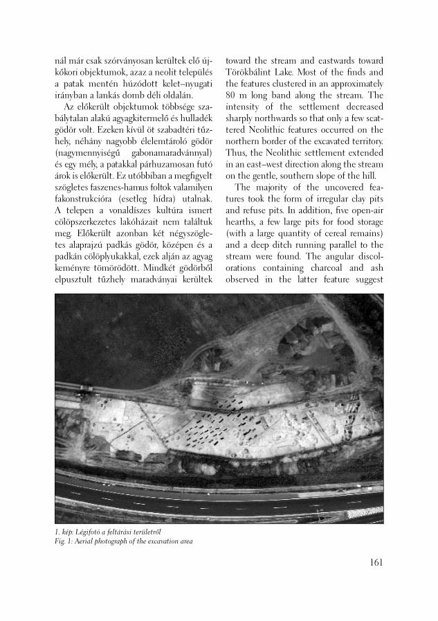
nál már csak szórványosan kerültek elő új-kőkori objektumok, azaz a neolit település a patak mentén húzódott kelet–nyugati irányban a lankás domb déli oldalán. Az előkerült objektumok többsége sza-bálytalan alakú agyagkitermelő és hulladék gödör volt. Ezeken kívül öt szabadtéri tűz-hely, néhány nagyobb élelemtároló gödör (nagy mennyiségű gabonamaradvánnyal) és egy mély, a patakkal párhuzamosan futó árok is előkerült. Ez utóbbiban a megfi gyelt szögletes faszenes-hamus foltok valamilyen fakonstrukcióra (esetleg hídra) utalnak. A telepen a vonaldíszes kultúra ismert cölöpszerkezetes lakóházait nem találtuk meg. Előkerült azonban két négyszögle-tes alaprajzú padkás gödör, középen és a padkán cölöplyukakkal, ezek alján az agyag keményre tömörödött. Mindkét gödörből elpusztult tűzhely maradványai kerültek
1. kép: Légifotó a feltárási területrőlFig. 1: Aerial photograph of the excavation area
toward the stream and eastwards toward Törökbálint Lake. Most of the fi nds and the features clustered in an approximately 80 m long band along the stream. The intensity of the settlement decreased sharply northwards so that only a few scat-tered Neolithic features occurred on the northern border of the excavated territory. Thus, the Neolithic settlement extended in an east–west direction along the stream on the gentle, southern slope of the hill. The majority of the uncovered fea-tures took the form of irregular clay pits and refuse pits. In addition, fi ve open-air hearths, a few large pits for food storage (with a large quantity of cereal remains) and a deep ditch running parallel to the stream were found. The angular discol-orations containing charcoal and ash observed in the latter feature suggest
161
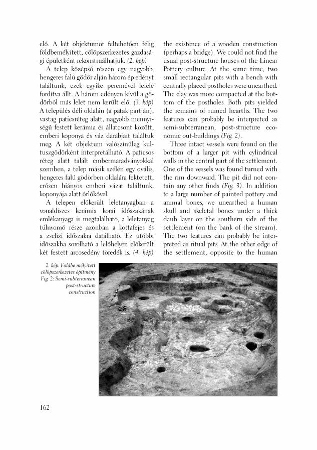
elő. A két objektumot feltehetően félig földbemélyített, cölöpszerkezetes gazdasá-gi épületként rekonstruálhatjuk. (2. kép) A telep középső részén egy nagyobb, hengeres falú gödör alján három ép edényt találtunk, ezek egyike peremével lefelé fordítva állt. A három edényen kívül a gö-dörből más lelet nem került elő. (3. kép) A település déli oldalán (a patak partján), vastag paticsréteg alatt, nagyobb mennyi-ségű festett kerámia és állatcsont között, emberi koponya és váz darabjait találtuk meg. A két objektum valószínűleg kul-tuszgödörként interpretálható. A paticsos réteg alatt talált embermaradványokkal szemben, a telep másik szélén egy ovális, hengeres falú gödörben oldalára fektetett, erősen hiányos emberi vázat találtunk, koponyája alatt őrlőkővel. A telepen előkerült leletanyagban a vonaldíszes kerámia korai időszakának emlékanyaga is megtalálható, a leletanyag túlnyomó része azonban a kottafejes és a zselízi időszakra datálható. Ez utóbbi időszakba sorolható a lelőhelyen előkerült két festett arcosedény töredék is. (4. kép)
162
2. kép: Földbe mélyített cölöpszerkezetes építményFig. 2: Semi-subterranean
post-structure construction
the existence of a wooden construction (perhaps a bridge). We could not fi nd the usual post-structure houses of the Linear Pottery culture. At the same time, two small rectangular pits with a bench with centrally placed postholes were unearthed. The clay was more compacted at the bot-tom of the postholes. Both pits yielded the remains of ruined hearths. The two features can probably be interpreted as semi-subterranean, post-structure eco-nomic out-buildings (Fig. 2). Three intact vessels were found on the bottom of a larger pit with cylindrical walls in the central part of the settlement. One of the vessels was found turned with the rim downward. The pit did not con-tain any other fi nds (Fig. 3). In addition to a large number of painted pottery and animal bones, we unearthed a human skull and skeletal bones under a thick daub layer on the southern side of the settlement (on the bank of the stream). The two features can probably be inter-preted as ritual pits. At the other edge of the settlement, opposite to the human

3. kép: Kultuszgödör szájjal lefelé fordított
edénnyelFig. 3: Ritual pit with an
upside down vessel
Az edénytípus a zselízi kultúra területén széleskörben elterjedt (KUZMA 1990, KALICZ 1998 22–33), így lelőhelyünk köz-vetlen közelében fekvő lelőhelyeken (Bia-torbágy-Tyúkberek, Törökbálint-Du lács ka) több változata is előkerült. (VIRÁG 1998) Az újkőkori településrészlet – hasonló korú lelőhelyek radicarbon adatai alapján – a Kr. e. 6.-5. évezredre datálható. A területen a Kr. e. 3. évezred középső harmadában a makói kultúra népessége létesített a kultúrára jellemző, (CSÁNYI 1996, SZATHMÁRI 1998-99) erősen szórt szerkezetű települést. Viszonylag nagy te-rületen néhány hengeres falú hulladékgö-dör jelezte ezt a kronológiai horizontot. A kora bronzkori telep az 1991-es feltárások tanúsága szerint, észak felé folytatódott, de a telep ebben az irányban sem volt in-tenzívebb. Ugyancsak a korábban előkerült kora vaskori teleprészlethez kapcsolható az ásatás során előkerült egyetlen kora vaskori gödör. A lelőhelyet egymást merőlegesen ke-resztező árkok osztják több részre, több helyen megfi gyelhető volt, hogy az árkot
remains brought to light from under the daub layer, we found a very fragmentary human skeleton laid on its side and with a quern placed under the skull, lying in an oval pit with vertical walls. The fi nd material recovered from the site contained fi nd material from the early phase of the Linear Pottery culture as well, although the majority of the fi nds date from the Notenkopf and Zseliz phases of the Linear Band culture. Two fragments of face-pots date from this latter phase (Fig. 4). This vessel type was wide spread in the territory of the Zseliz culture (KUZMA 1990, KALICZ 1998 22-33), and some versions of it have been found at nearby sites (Biatorbágy-Tyúkberek, Törökbálint-Dulácska) (VIRÁG 1998). This Neolithic settlement fragment can be dated from the 6th-5th millennium BC based on radiocarbon dates from sites be-longing to the same cultural phase. The population of the Makó culture established its characteristic settlements with their widely scattered structures (CSÁNYI 1996, SZATHMÁRI 1998-99)
163

4. kép: Arcosedény töredékFig. 4: Fragment of a face-pot
kőrakások kísérik. Az árkok betöltéséből néhány tegulatöredék és egy római kori kerámiatöredék került elő. Az árokrend-szer valószínűleg a lelőhely közelében ko-rábban feltárt római kori villával hozható kapcsolatba. Az egyik, árkok által határolt téglalap alakú területen 64 avar sír került elő, te-hát az avar korban feltételezhetően még látszott az árokrendszer nyoma. Az autó-pálya-bővítés nyomvonalába 64 sír esett, a temetőrészlet három oldalról lezártnak tekinthető. Újabb sírok előkerülésére a ki-sa já títási határon kívül, délkeleti irányban lehet számítani. A temetkezések rövid, dél–délnyu-gat-észak–északkelet irányú sorokba rendeződnek, a férfi , női és gyermeksírok területileg nem különülnek el. A mellékletek alapján a sírok két kor-szakhoz tartoztak. A 7. század középső harmadára datálható férfi sírokból P-fülű kardok, csontmerevítős refl exíjak, nyíl-hegyek, tegezmaradványok, préselt bronz övveretek, arany fülbevalók kerültek elő. (5. kép) Kiemelésre érdemes az egyik fegyveres férfi sírban talált aranylemezből készült pénzutánzat. A női sírok mellék-letei karperecek, gyöngyök, orsógombok voltak. Hasonló korú temetők a főváros környékéről például a XIV. ker. Tihany térről ismertek (NAGY 1998, 112–122), a két P-fülű kard párhuzama pedig Csepel-Kavicsbánya lelőhelyről ismert. (NAGY 1998, 178-180) A sírok túlnyomó része a késő avar kor-ra, a 8. század második felére datálható. A késő avar sírok nagy részét (elsősorban a felnőtt férfi akét) még a korszakban kira-bolták, így a vázak erősen hiányosak, és valószínű, hogy a mellékletek többségét elvitték. A férfi sírokban fegyverövek ön-tött griffes-indás bronzvereteit, szíjvé-
164
in the middle third of the 3rd millenni-um BC. A few refuse pits with vertical walls indicate that this chronological ho-rizon is present over a relatively large terri-tory. The Early Bronze Age settlements at Biatorbágy-Hosszúrétek extended further to the north, as suggested by the results of the excavations in 1991, although the settlement was not any more intensive in this direction either. The only Early Iron Age pit found during the excavation can be ascribed to the also previously unearthed segment of an Early Iron Age settlement. Sixty-four Avar graves were uncovered on an oblong territory bordered by the trenches. (This suggests that the trench system would still have been visible in the Avar period). The 64 graves were located along the pathof the motorway extension. The cem-etery fragment can be regarded as closed on three of its sides. More graves can be expected in a southeast direction beyond the edge of the territory impacted by mo-torway construction.
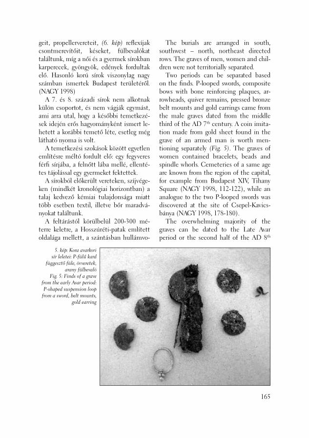
geit, propellervereteit, (6. kép) refl exíjak csontmerevítőit, késeket, fülbevalókat találtunk, míg a női és a gyermek sírokban karperecek, gyöngyök, edények fordultak elő. Hasonló korú sírok viszonylag nagy számban ismertek Budapest területéről. (NAGY 1998) A 7. és 8. századi sírok nem alkotnak külön csoportot, és nem vágják egymást, ami arra utal, hogy a későbbi temetkezé-sek idején erős hagyományként ismert le-hetett a korábbi temető léte, esetleg még látható nyoma is volt. A temetkezési szokások között egyetlen említésre méltó fordult elő: egy fegyveres férfi sírjába, a felnőtt lába mellé, ellenté-tes tájolással egy gyermeket fektettek. A sírokból előkerült vereteken, szíjvége-ken (mindkét kronológiai horizontban) a talaj kedvező kémiai tulajdonsága miatt több esetben textil, illetve bőr maradvá-nyokat találtunk. A feltárástól körülbelül 200-300 mé-terre keletre, a Hosszúréti-patak említett oldalága mellett, a szántásban hullámvo-
5. kép: Kora avarkori sír leletei: P-fülű kard
függesztő füle, övveretek, arany fülbevaló
Fig. 5: Finds of a grave from the early Avar period: P-shaped suspension loop
from a sword, belt mounts, gold earring
The burials are arranged in south, southwest – north, northeast directed rows. The graves of men, women and chil-dren were not territorially separated. Two periods can be separated based on the fi nds. P-looped swords, composite bows with bone reinforcing plaques, ar-rowheads, quiver remains, pressed bronze belt mounts and gold earrings came from the male graves dated from the middle third of the AD 7th century. A coin imita-tion made from gold sheet found in the grave of an armed man is worth men-tioning separately (Fig. 5). The graves of women contained bracelets, beads and spindle whorls. Cemeteries of a same age are known from the region of the capital, for example from Budapest XIV, Tihany Square (NAGY 1998, 112-122), while an analogue to the two P-looped swords was discovered at the site of Csepel-Kavics-bánya (NAGY 1998, 178-180). The overwhelming majority of the graves can be dated to the Late Avar period or the second half of the AD 8th
165

6. kép: Késő avar férfi sír feltárás közbenFig. 6: The grave of a late Avar man during cleaning
naldíszes kerámiatöredékeket találtunk. A leletek valószínűleg egy avar teleppel kapcsolhatók össze, ehhez tartozhattak az általunk feltárt sírok. A lelőhely környékén egyébként több avar temető ismert, (MARÓTI 2002) ami a terület avar kori sűrű lakottságára utal. A legközelebbi temető lelőhelyünktől körülbelül 1,5–2 kilométerre, az M1 autó-pálya és a 100-as főút között került elő (Biatorbágy-Budapark). A feltárt 450 sírt az ásatók a 7. század negyedik negyede és a 9. század első negyede közötti időszakra datálták, (SIMON 1993) azaz részben egy időben használták a Hosszúréteken előke-rült temetőrészlettel.
Reményi László – Tóth Anikó
166
Irodalom/References:
CSÁNYI 1996 – Csányi M.: Újabb adat kelet-magyarországi kora bronzkorunkhoz – New data to the Early Bronze Age of East Hungary. Tisicum 9 (1996) 45–75.
century. Most of the late Avar graves (espe-cially all those of adult men) had already been robbed in the same period, so the skeletons are badly fragmented and most probably the majority of the grave goods were taken away. In the graves of men we found cast griffi n-and-tendril bronze mounts, strap-ends and bow-tie mounts from weapon belts (Fig. 6), bone reinforc-ing plaques for composite bows, knives and earrings, while the graves of women and children contained bracelets, beads and vessels. Many graves from the same period are known from the territory of Budapest (NAGY 1998). The graves from the AD 7th and 8th cen-turies do not comprise a separate group. They do not intersect one another, which implies that the memory of the earlier cemetery was preserved as a strong tradi-tion at the time of the later burials, or it was perhaps still visible. There was a noteworthy burial rite: a child was placed at the foot of an armed adult man lying in an opposite orienta-tion.
KALICZ 1998 – Kalicz, N.: Figürliche Kunst und bemalte Keramik aus dem Ne-olithikum Westungarns. Budapest 1998.KUZMA 1990 – Kuzma, I.: Plastika želie-zovskej skupiny z Mužle-Čenkova. Plastik der Želiezovce-Gruppe aus Mužla-Čenkov. SlovArch 38-2 (1990) 429–452.MARÓTI 2002 – Maróti É.: Avar temető Sóskúton. (Ein awarisches Gräberfeld in Sóskút.)Régészeti kutatások Magyarorszá-gon 1999. Budapest 2002, 109–129. NAGY 1998 – Nagy, M.: Awarenzeitliche Gräberfelder im Stadtgebiet von Budapest I-II. Budapest 1998. SIMON 1993 – Simon L.: Kőpakolásos temetkezések a biatorbágyi avar temető-ben (előzetes jelentés). Bestattungen mit Steinsetzung im awarischen Gräberfeld von Biatorbágy. HOMÉ 30-31 (1993) 141–170.SZATHMÁRI 1998-99 – Szathmári I.: Ada tok a kora bronzkori makói kultú-ra kér déséhez. Beiträge zur Frage der frühbronzezeitlichen Makó-Kultur. Sava-ria – pars archaeologica 24/3 (1998-99), 141–152.VIRÁG 1998 – Virág, Zs.: Neuere anth-ropomorphe Darstellungen der Linien-bandkeramik aus dem Umgebung von Budapest. In: The Late Neolithic of the Middle Danube Region. Timişoara 1998, 67–89.
In numerous cases, we found remains of textile and leather on the mounts and strap-ends recovered from the graves (from both chronological horizons) owing to the favourable chemical properties of the soil. Sherds ornamented with wavy lines were found in the ploughed fi eld by the above-mentioned side-tributary of the Hosszúréti stream, about 200-300 m east of the excavation. They can probably be linked with the Avar settlement to which the unearthed graves belonged. Several Avar cemeteries are known in the environs of the site (MARÓTI 2002), which shows that the area was densely populated in the Avar period. The clos-est cemetery was located about 1.5–2 km from this site, between the M1 motorway and national road no. 100 (Biatorbágy-Bu-dapark). The 450 graves unearthed there were dated from between the fourth quarter of the AD 7th century and the fi rst quarter of the AD 9th century (SIMON 1993), which means that they were partly contemporary with the cemetery frag-ment unearthed at Hosszúrétek.
László Reményi – Anikó Tóth
167

A lelőhely a Hosszúréti-pataktól nyugatra, körülbelül 1 kilométeres távolságra, eny-he, lankás, déli lejtőn fekszik, Biatorbágy és Törökbálint közigazgatási határán. Az M0 autópálya építését megelőzően End-rődi Anna, Nyékhelyi Dorottya és Virág Zsuzsanna folytatott megelőző feltárást, amelynek során újkőkori, középkori tele-pülés nyomai kerültek elő (BTM Adattár: 1683-92, 1707-93). A 2003-ban folytatott megelőző feltá-rásunk során – a talajtani szakvélemény (Mindszenty Andrea – Horváth Zoltán) fi gyelembevételével – megállapítható volt, hogy a lelőhelyet fedő eredeti humuszréteg jelentős részét, a régészeti leleteket tartal-mazó kultúrréteggel együtt, feltehetően az autópálya építés során elhordták és ta-lajcserét végeztek. Ennek következtében az objektumoknak csak a sárga altalajba mélyülő részét tudtuk feltárni, és leleteket is csak ezekből tudtunk gyűjteni. Az ásatás során a már korábban fel-tárt újkőkori település néhány további objektumát sikerült feltárnunk. Néhány hulladékgödör és semmilyen konstrukciót nem alkotó cölöplyuk mellett, sikerült feltárnunk egy cölöpszerkezetes ház részletét. (1. kép) A viszonylag mélyen a sárga altalajba mélyülő cölöplyukak négy sort alkotnak, a ház északnyugat–délke-leti tájolású, sajnos a vonaldíszes körben
Őskori és középkori leletek Biatorbágy-Tyúkberek, Törökbálint-Kukoricadűlő lelőhelyről
(Biatorbágy–Törökbálint, M0 autópálya nyomvonala, PM 014-015. lelőhely)
168
Prehistoric and medieval fi nds from Biatorbágy-Tyúkberek, Törökbálint-Kukoricadűlő site
(Biatorbágy–Törökbálint, Path of the M0 motorway, site PM 014-015)
The site lies on a gentle southern slope about 1 km west of the Hosszúréti stream, on the administrative boundary between Biatorbágy and Törökbálint. Anna Endrődi, Dorottya Nyékhelyi and Zsuzsanna Virág conducted excavations preceding the construction of M0 mo-torway. They brought to light remains of Neolithic and medieval settlements (Budapest Historical Museum Archives: 1683-92, 1707-93). The excavations of 2003 and the pe-dological analyses (Andrea Mindszenty – Zoltán Horváth) revealed that a signifi -cant portion of the humus layer that had originally covered the surface (together with the culture-bearing layer with the fi nds) had been removed during the con-struction of the highway and a different soil fi lled in there. In consequence, only those parts of the features that had been dug into the yellow substratum could be unearthed. All the fi nds come from the bottom of these features. We unearthed a few more features from the previously described Early Neo-lithic settlement. Beside a few refuse pits and postholes, not forming any kind of building outline, we uncovered part of post-structure house (Fig. 1). The post-holes, which were dug relatively deeply into the yellow substratum, were aligned
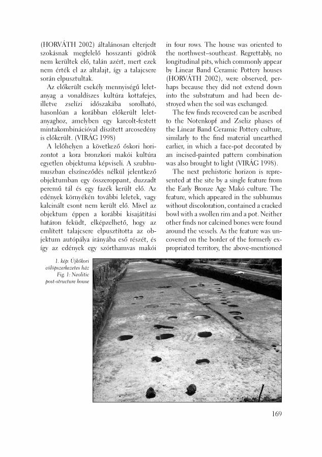
(HORVÁTH 2002) általánosan elterjedt szokásnak megfelelő hosszanti gödrök nem kerültek elő, talán azért, mert ezek nem érték el az altalajt, így a talajcsere során elpusztultak. Az előkerült csekély mennyiségű lelet-anyag a vonaldíszes kultúra kottafejes, illetve zselízi időszakába sorolható, hasonlóan a korábban előkerült lelet-anyaghoz, amelyben egy karcolt-festett mintakombinációval díszített arcosedény is előkerült. (VIRÁG 1998) A lelőhelyen a következő őskori hori-zontot a kora bronzkori makói kultúra egyetlen objektuma képviseli. A szubhu-muszban elszíneződés nélkül jelentkező objektumban egy összeroppant, duzzadt peremű tál és egy fazék került elő. Az edények környékén további leletek, vagy kalcinált csont nem került elő. Mivel az objektum éppen a korábbi kisajátítási határon feküdt, elképzelhető, hogy az említett talajcsere elpusztította az ob-jektum autópálya irányába eső részét, és így az edények egy szórthamvas makói
1. kép: Újkőkori cölöpszerkezetes ház
Fig. 1: Neolitic post-structure house
in four rows. The house was oriented to the northwest–southeast. Regrettably, no longitudinal pits, which commonly appear by Linear Band Ceramic Pottery houses (HORVÁTH 2002), were observed, per-haps because they did not extend down into the substratum and had been de-stroyed when the soil was exchanged. The few fi nds recovered can be ascribed to the Notenkopf and Zseliz phases of the Linear Band Ceramic Pottery culture, similarly to the fi nd material unearthed earlier, in which a face-pot decorated by an incised-painted pattern combination was also brought to light (VIRÁG 1998). The next prehistoric horizon is repre-sented at the site by a single feature from the Early Bronze Age Makó culture. The feature, which appeared in the subhumus without discoloration, contained a cracked bowl with a swollen rim and a pot. Neither other fi nds nor calcined bones were found around the vessels. As the feature was un-covered on the border of the formerly ex-propriated territory, the above-mentioned
169

sírhoz tartozhattak. Egyelőre azonban nem tudjuk megfelelően interpretálni az objektumot. 1991-ben az M0 autópálya építését megelőző régészeti feltárások során 13. szá zadi település került elő, melyet B. Nyékhelyi Dorottya publikált. (NYÉK-HELYI 1992) Feltárásunk a korábbi kutatástól kele-tebbre esett, és hosszú szakaszon sikerült mind Törökbálint-Kukoricadűlőben, mind Biatorbágy-Tyúkberek területén 20–25 méteres sávban újabb információkat gyűj-teni. A 2003-ban folytatott ásatás során megtaláltuk az északi (2. számú objek-tum) illetve a déli területen (169. számú objektum) egy-egy kelet – nyugat irányú árkot, amely közrefogta az Árpád-kori objektumokat. Ezen belül tárológödröket bontottunk ki (3., 4., 27., 94. számú ob-jektumok), melyből vaspatkó, sarló vala-mint Árpád-kori kerámiaanyag került elő. Több szabadon álló tüzelőhely is feltárásra került (5., 11. objektumok). A területen a nagyszámú cölöplyuk feltehetően állattar-táshoz köthető (karámok). Megemlítésre méltó a 170. objektum, mely a két mai település határán található. A köves, ka-vicsos felszín a geológusok szakvéleménye alapján, természetes úton nem jöhetett létre, így valószínűsíthetünk egy egykori járószintet. Összefoglalóan elmondható, hogy az 1991-ben kutatott Árpád-kori falurészlet újabb területét sikerült feltárni. 2003-ban földbemélyített ház nem került elő, de jelentős, hogy megtaláltuk azt a két ár-kot, ami feltételezésünk szerint hatá rolta a települést. Nyékhelyi Dorottya által korábban megfi gyelteket (NYÉKHELYI 1992, 176) alátámasztotta az ásatás, erről a területről is nagyon kevés leletanyag ke-
170
exchange of the soil could have destroyed the part of the feature lying closer to the highway. In this case, the vessels may be-long to a Makó grave with a scattered ash rite, but it is not yet possible to precisely interpret the feature. A settlement from the 13th century was uncovered during the excavation preced-ing the construction of highway M0 in 1991. The results of these excavations were published by Dorottya B. Nyékhelyi published (NYÉKHELYI 1992). This time, we excavated east of the former excavation and further informa-tion could be collected within a long, 20–25 m wide zone both in Tö rök bá-lint-Kukoricadűlő and Biatorbágy-Tyúk-berek. During the course of the excavation in 2003 we found each an east–west run-ning ditch on the northern (feature no. 2) and the southern parts of the territories (feature no. 169) enclosing features from the Árpád period. On this territory we un-earthed storage pits (features nos. 3, 4, 27, 94), which contained an iron horseshoe, a sickle and shards from the Árpád period. A number of open-air ovens were also brought to light (features nos. 5 and 11). The large number of postholes is probably related to animal keeping (pens). Feature no. 170, which was found on the border of the two modern settlements, should be mentioned separately. According to geolo-gists, the stony, gravely surface is a not a natural phenomenon but probably mark a former fl oor level. In summary, it is possible to say that a new area from the Árpád period vil-lage fragment investigated in 1991 was unearthed during recent excavations. In 2003, we did not uncover semi-subterra-nean houses. The signifi cant result was
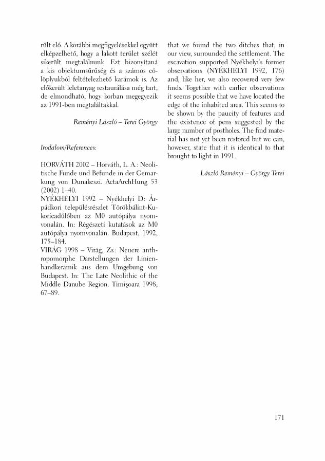
rült elő. A korábbi megfi gyelésekkel együtt elképzelhető, hogy a lakott terület szélét sikerült megtalálnunk. Ezt bizonyítaná a kis objektumsűrűség és a számos cö-löplyukból feltételezhető karámok is. Az előkerült leletanyag restaurálása még tart, de elmondható, hogy korban megegyezik az 1991-ben megtaláltakkal.
Reményi László – Terei György
Irodalom/References:
HORVÁTH 2002 – Horváth, L. A.: Neoli-tische Funde und Befunde in der Gemar-kung von Dunakeszi. ActaArchHung 53 (2002) 1–40.NYÉKHELYI 1992 – Nyékhelyi D.: Ár-pádkori településrészlet Törökbálint-Ku-koricadűlőben az M0 autópálya nyom-vonalán. In: Régészeti kutatások az M0 autópálya nyomvonalán. Budapest, 1992, 175–184.VIRÁG 1998 – Virág, Zs.: Neuere anth-ropomorphe Darstellungen der Linien-bandkeramik aus dem Umgebung von Budapest. In: The Late Neolithic of the Middle Danube Region. Timişoara 1998, 67–89.
that we found the two ditches that, in our view, surrounded the settlement. The excavation supported Nyékhelyi’s former observations (NYÉKHELYI 1992, 176) and, like her, we also recovered very few fi nds. Together with earlier observations it seems possible that we have located the edge of the inhabited area. This seems to be shown by the paucity of features and the existence of pens suggested by the large number of postholes. The fi nd mate-rial has not yet been restored but we can, however, state that it is identical to that brought to light in 1991.
László Reményi – György Terei
171

2003. augusztus 21. és október 1. kö zött végeztünk régészeti feltárást az M0 au-tóút kiszélesítése kapcsán a Laki hegyi lehajtó által közrezárt területen. (1. kép) A lelőhely a Csepel-szigeten, a Budafo-ki-(Nagy)-Dunaágtól körülbelül 400 mé-terre, a Duna által homokos kavicsból és folyóvízi homokból épített II/a. teraszon található. Az M0 autópálya építését meg-előzően a lelőhely közelében, a Dunához közelebb Melis Katalin végzett megelőző feltárást, amelynek során kora bronzkori és középkori telepobjektumokat tárt fel (BTM Adattár: 1649-91). A területen három, a lehajtóra merő-leges kutatóárokkal kezdtük meg a feltá-rást. Ezek közül a Dunához legközelebb esőben már a humusz eltávolítása során nagymennyiségű bronzkori kerámiatöre-dék került elő. Az árkok kiszélesítése, és összefüggő területté alakítása során a sárga altalajban objektumfoltok jelent-keztek. Az általunk kutatott terülten 35 objektumot sikerült feltárni. Ezek, a 19. objektumon – Árpád-kori kemence és tőle keletre nagyméretű munkagödör – kívül bronzkori beásások voltak A területen hat, félkör ívben elhelyez-kedő ovális gödör került elő. A gödrök betöltéséből néhány darab kerámiatöre-dék, csontok, kövek kerültek elő. Az északi területen a nagyméretű objektumfoltból
Szigetszentmiklós-Laki hegy-Dunára-dűlő
(Szigetszentmiklós, M0 autópálya nyomvonala, PM 010. lelőhely)
172
Szigetszentmiklós-Laki hegy-Dunára-dűlő
(Szigetszentmiklós, path of the M0 motorway, site PM 010)
Archaeological excavations were conducted on the territory enclosed by the Laki-hegy exit preceding extension of the M0 mo-torway between August 21 and October 1, 2003 (Fig. 1). The site is located on Csepel Island, about 400 m from the Bu-dafok (Large) branch of the Danube, on terrace II/a composed of sandy gravel and alluvial sand deposited by the Danube. Katalin Melis conducted excavations near this site, closer to the Danube, preceding the construction of the M0 motorway. She unearthed settlement features from the Bronze Age and the Middle Ages
1. kép: Az ásatás látképeFig. 1: General view of the excavation
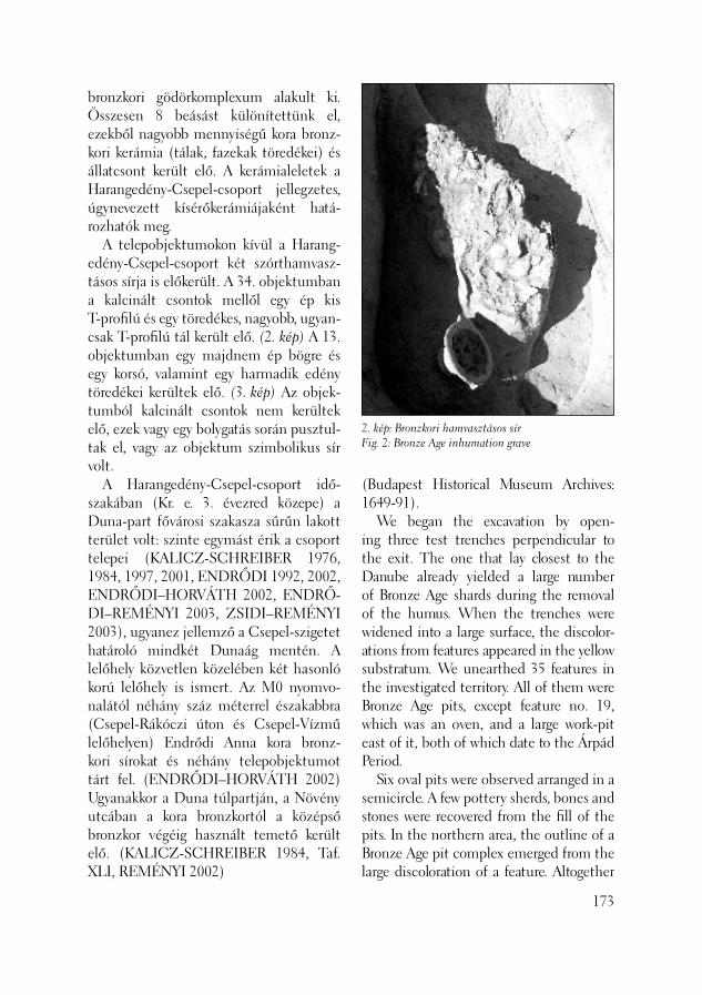
2. kép: Bronzkori hamvasztásos sírFig. 2: Bronze Age inhumation grave
bronzkori gödörkomplexum alakult ki. Összesen 8 beásást különí tettünk el, ezekből nagyobb mennyiségű kora bronz-kori kerámia (tálak, fazekak töredékei) és állatcsont került elő. A kerámialeletek a Harangedény-Csepel-csoport jellegzetes, úgynevezett kísérőkerámiájaként hatá-rozhatók meg. A telepobjektumokon kívül a Harang-edény-Csepel-csoport két szórthamvasz-tásos sírja is előkerült. A 34. objektumban a kalcinált csontok mellől egy ép kis T-profi lú és egy töredékes, nagyobb, ugyan-csak T-profi lú tál került elő. (2. kép) A 13. objektumban egy majdnem ép bögre és egy korsó, valamint egy harmadik edény töredékei kerültek elő. (3. kép) Az objek-tumból kalcinált csontok nem kerültek elő, ezek vagy egy bolygatás során pusztul-tak el, vagy az objektum szimbolikus sír volt. A Harangedény-Csepel-csoport idő-szakában (Kr. e. 3. évezred közepe) a Duna-part fővárosi szakasza sűrűn lakott terület volt: szinte egymást érik a csoport telepei (KALICZ-SCHREIBER 1976, 1984, 1997, 2001, ENDRŐDI 1992, 2002, ENDRŐDI–HORVÁTH 2002, ENDRŐ-DI–REMÉNYI 2003, ZSIDI–REMÉNYI 2003), ugyanez jellemző a Csepel-szigetet határoló mindkét Dunaág mentén. A lelőhely közvetlen közelében két hasonló korú lelőhely is ismert. Az M0 nyomvo-nalától néhány száz méterrel északabbra (Csepel-Rákóczi úton és Csepel-Vízmű lelőhelyen) Endrődi Anna kora bronz-kori sírokat és néhány telepobjektumot tárt fel. (ENDRŐDI–HORVÁTH 2002) Ugyanakkor a Duna túlpartján, a Növény utcában a kora bronzkortól a középső bronzkor végéig használt temető került elő. (KALICZ-SCHREIBER 1984, Taf. XLI, REMÉNYI 2002)
(Budapest Historical Museum Archives: 1649-91). We began the excavation by open-ing three test trenches perpendicular to the exit. The one that lay closest to the Danube already yielded a large number of Bronze Age shards during the removal of the humus. When the trenches were widened into a large surface, the discolor-ations from features appeared in the yellow substratum. We unearthed 35 features in the investigated territory. All of them were Bronze Age pits, except feature no. 19, which was an oven, and a large work-pit east of it, both of which date to the Árpád Period. Six oval pits were observed arranged in a semicircle. A few pottery sherds, bones and stones were recovered from the fi ll of the pits. In the northern area, the outline of a Bronze Age pit complex emerged from the large discoloration of a feature. Altogether
173
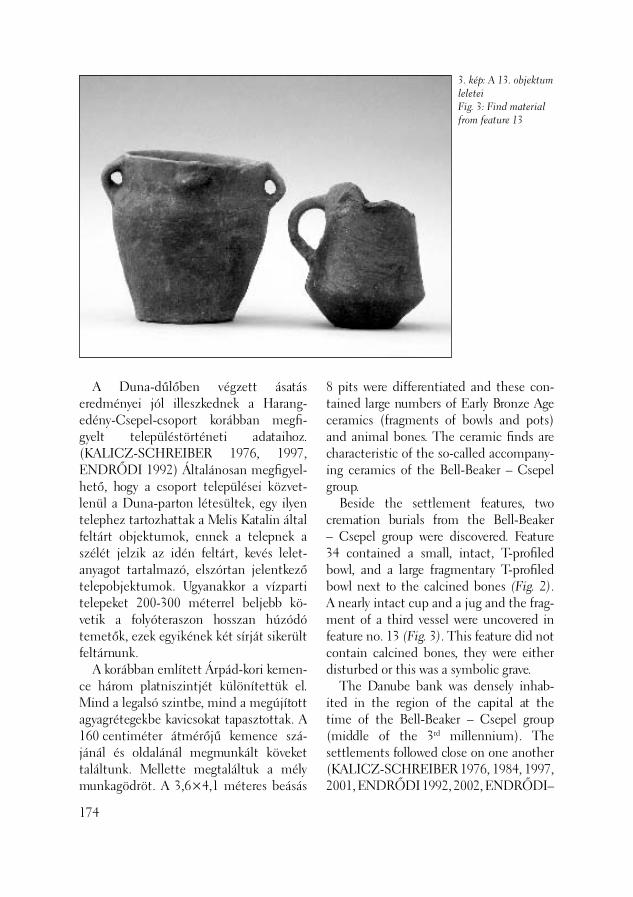
3. kép: A 13. objektum leleteiFig. 3: Find material from feature 13
A Duna-dűlőben végzett ásatás ered ményei jól illeszkednek a Harang-edény-Csepel-csoport korábban megfi -gyelt településtörténeti adataihoz. (KA LICZ-SCHREI BER 1976, 1997, END RŐ DI 1992) Általánosan megfi gyel-hető, hogy a csoport települései közvet-lenül a Duna-parton létesültek, egy ilyen telephez tartozhattak a Melis Katalin által feltárt objektumok, ennek a telepnek a szélét jelzik az idén feltárt, kevés lelet-anyagot tartalmazó, elszórtan jelentkező telepobjektumok. Ugyanakkor a vízparti telepeket 200-300 méterrel beljebb kö-vetik a folyóteraszon hosszan húzódó temetők, ezek egyikének két sírját sikerült feltárnunk. A korábban említett Árpád-kori kemen-ce három platniszintjét különítettük el. Mind a legalsó szintbe, mind a megújított agyagrétegekbe kavicsokat tapasztottak. A 160 centiméter átmérőjű kemence szá-jánál és oldalánál megmunkált köveket találtunk. Mellette megtaláltuk a mély munkagödröt. A 3,6×4,1 méteres beásás
174
8 pits were differentiated and these con-tained large numbers of Early Bronze Age ceramics (fragments of bowls and pots) and animal bones. The ceramic fi nds are characteristic of the so-called accompany-ing ceramics of the Bell-Beaker – Csepel group. Beside the settlement features, two cremation burials from the Bell-Beaker – Csepel group were discovered. Feature 34 contained a small, intact, T-profi led bowl, and a large fragmentary T-profi led bowl next to the calcined bones (Fig. 2). A nearly intact cup and a jug and the frag-ment of a third vessel were uncovered in feature no. 13 (Fig. 3). This feature did not contain calcined bones, they were either disturbed or this was a symbolic grave. The Danube bank was densely inhab-ited in the region of the capital at the time of the Bell-Beaker – Csepel group (middle of the 3rd millennium). The settlements followed close on one another (KALICZ-SCHREIBER 1976, 1984, 1997, 2001, ENDRŐDI 1992, 2002, ENDRŐDI–
déli oldalán méhkas alakú tárológödröt ástak. Hamus, paticsos betöltéséből nagy-mennyiségű Árpád-kori kerámiaanyag ke-rült elő. A délkeleti oldalon találtuk meg a lejáratot. Összefoglalva elmondható, hogy a ko-rábbi M0-ás ásatások során feltárt bronz-kori és Árpád-kori település délkeleti vége így meghatározhatóvá vált. Az előkerült objektumokat és leletanyagot összevetjük a korábbi kutatások eredményeivel, amely után komplexebb képet kapunk az egész területről.
Reményi László – Terei György
Irodalom/References:
ENDRŐDI 1992 – Endrődi A.: A kora-bronzkori Harangedény kultúra telepe és temetője Szigetszentmiklós határában. [The settlement and cemetery of the Bell-Beaker Culture in the district of Szi-getszentmiklós] In: Régészeti kutatások az M0 autópálya nyomvonalán I. Budapest 1992, 83–201.ENDRŐDI 2002 – Endrődi A.: Kora-bronzkori telepfeltárás Budapest Albert-falván. (The excavation of an Early Bronze Age settlement at Budapest-Albertfalva.) Aqfüz 8 (2002) 81–91.ENDRŐDI–HORVÁTH 2002 – Endrődi A. – Horváth A. M.: Kora bronzkori és avar sírok Budapest, Csepel-szigeten. (Early Bronze Age at Budapest, Csepel-Island.) In: Régészeti kutatások Magyarországon 1999. Budapest 2002, 27–45. ENDRŐDI–REMÉNYI 2003 – Endrődi A. – Reményi L.: Az Albertfalva, 6-os számú főút bővítését megelőző régészeti feltárás eredményei. (The results of the excavations preceding the enlargement
HORVÁTH 2002, ENDRŐDI–REMÉ-NYI 2003, ZSIDI – REMÉNYI 2003), and the same situation was characteristic on Csepel Island along both branches of the Danube. Two sites of similar age are known near the site. Anna Endrődi un-earthed Early Bronze Age graves and a few settlement features a few hundred metres to the north (at Csepel-Rákóczi Road and Csepel-Vízmű sites) (ENDRŐDI–HOR-VÁTH 2002), and a cemetery used from the Early Bronze Age to the end of the Middle Bronze Age was discovered on Növény Street on the opposite bank of the Danube (KALICZ-SCHREIBER 1984, Taf. XLI, REMÉNYI 2002). The results of the excavation conducted in Duna-dűlő fi t into the earlier observed settlement historical data for the Bell-Bea-ker – Csepel group (KALICZ-SCHREI-BER 1976, 1997, ENDRŐDI 1992). It can be observed, in general, that the settlements of this group were established on the banks of the Danube. The features unearthed by Katalin Melis may belong to such a settlement while the scattered settlement features with only a few fi nds uncovered this year mark the edge of the same settlement. At the same time, the extended cemeteries followed the riverside settlements, 200-300 meters away from the Danube. Two graves from such a cemetery were unearthed. Three baking surfaces from the above-mentioned Árpád Period oven could be distinguished. Pebbles were pasted into the lowermost surface as well as into the renewed surfaces. Dressed stones were found by the mouth and the sides of the oven, which hd a diameter of 160 cm. Be-side the oven, we found a deep work-pit. A beehive-shaped storage pit was dug into the southern side of the 3.6×4.1 m pit.
175
176
of route 6 by Albertfalva.) Aqfüz 9 (2003) 146–150.KALICZ-SCHREIBER 1976 – Ka-licz-Schreiber, R.: Die Probleme der Glock-enbecherkultur in Ungarn. In: Glock-enbecher Symposion Oberried 1974. Bussum/Haarlem. 1976, 183–215.KALICZ-SCHREIBER 1984 – Ka-licz-Schrei ber, R.: Komplex der Nagy-rév-Kul tur. In: Kulturen der Früh-bron ze zeit das Karpatenbeckens und Nord balkans. (Hrsg. Nikola Tasić) Beo-grad, 1984, 133–194.KALICZ-SCHREIBER 1997 – Ka-licz-Schreiber, R.: Kora bronzkori temet-kezések a Csepel-sziget keleti partján. (Frühbronzezeitliche Bestattungen am östlichen Ufer der Csepel-Insel bei Buda-pest.) BudRég 31 (1997) 182–197.KALICZ-SCHREIBER 2001 – Ka-licz-Schreiber, R.: Veränderungen der Besiedlungsdichte in der Umgebung von Budapest während des 3. Jahrtausends v. Chr. – Changes in settlement density in the Budapest area during the 3rd milleni-um BC. In: Mensch und Umwelt während des Neolithikums und der Frühbronzezeit in Mitteleuropa. (Hrsg. Lippert) A. et al. Leidorf, 2001, 165–170.REMÉNYI 2002 – Reményi L.: A Va-tya-kultúra Budatétény – Növény utcai te-metője. (Das Gräberfeld der Vatya Kultur in Budatétény – Növény Strasse.) BudRég 35 (2002) 77–101.ZSIDI–REMÉNYI 2003 – Zsidi P. – Re-ményi L.: Duna-parti út részlete és őskori maradványok a polgárvárostól délre. (De-tail from the road ont he Danube bank and prehistoric remains south of the Civil Town.) Aqfüz 9 (2003) 86–94.
The fi ll, mixed with ash and daub, yielded a rich ceramic material from the Árpád Period. The entrance was located on the southeast side of the feature. In summary, it appears it has fi nally been possible to identify the southeast end of the Bronze Age and Árpád Period features unearthed from the settlements during the excavations preceding the construction of the M0 motorway. The fea-tures and fi nds unearthed at this site will be compared with the results of the earlier investigation tin order to develop a more complex picture of the entire territory.
László Reményi – György Terei
1. Budapest, III. ker., Árpád utca – Ipartelep utca – Ságvári E. utca által határolt terület (Hrsz.: 63902/6)
A Budapesti Történeti Múzeum Ős- és Népvándorláskori Osztálya a Fővárosi Tűzoltóparancsnokság megbízásából a szóban forgó területen 2003. szeptember 3–8. között régészeti próbafeltárást vég-zett. A munka szükségességét a Pünkösd-fürdő közismert lelőhelyeinek és a dunai partszakasz relatív közelsége mellett a Szentendrei út melletti Shell kútnál talált középkori leletek, illetve a vicus Vindonia-nus feltételezett maradványai indokolták. A területen 4+1 szerállásos tűzoltó-laktanya és sportpálya épül, előbbinek cölöpalapozása miatt a leendő épületen kívül terveztük két, egymásra merőle-ges kutatóárok létesítését. A nagyjából 130×130×100 méter oldalhosszúságú, háromszög alakú, beépítetlen, füves, bok-ros telek járószintje a mai utcaszinthez képest 1,5–2 méterrel magasabban terül el; e feltöltés minden bizonnyal békásme-gyeri lakótelep építése során keletkezett, valamikor az 1970-es évek végén. Az 1. szondát északkelet–délnyugati irányban az Ipartelep-Árpád utca sarkától az Árpád utca vonalában, a Csillaghegyi árok mai patakmedre mentén húztuk meg 50 méter hosszúságban, 6 méter szélesség-
Az Aquincumi Múzeum kisebbés eredményei a 2003. évben
ben. Mivel 1,6–1,8 méter mélységben még javában újkori sittes feltöltésben jártunk, kénytelenek voltunk a további mélyítést már egy keskenyebb, 3 méter széles sávban végezni. Mintegy 2,6–3 méter mélységben ér-tünk el egy homogén, antropogén bolyga-tástól teljesen mentes sötétbarna-szürkés, igen kemény, tömött iszapos-agyagos réte-get, mely a GEORAM Kft. által végzett talajmechanikai vizsgálatok szerint a Du-na holocén kori ártéri üledéke. E réteg leg-felső, az újkori sittel közvetlenül érintkező részéből néhány újkori és egy római kori kerámiatöredéket gyűjtöttünk. A szonda déli végében egy 3×3 méteres négyzetben további 75 centimétert mélyültünk, ahol egy szürkésbarna kis kavicsokat tartalma-zó rétegbe értünk. Tekintettel az 1. szonda régészetileg ne-gatív jellegére, a kitermelt hatalmas mére-tű földdepóra, valamint arra a tényre, hogy az itt tapasztalt rétegviszonyok teljesség-gel megegyeznek az egész építési területre hasonló viszonyokat mutató fúrásminták eredményeivel, a 2. szonda megnyitását szakmailag már nem tartottuk indokolt-nak. A szóban forgó terület egykor minden bizonnyal a környező területekhez képest mélyebb, az emberi megtelepedésre al-kalmatlan áradmányos térszín lehetett. A
feltárásainak helyszínei
177
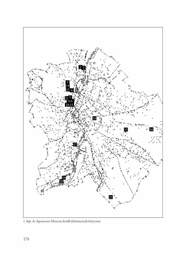
178
1 2
3
4
56-8
10-11
1413
15 16
17
18
1920
21
12
1. kép: Az Aquincumi Múzeum kisebb feltárásainak helyszínei
közeli magaslatokon való emberi jelenlétre utalhat a néhány római- és újkori cserép-töredék.
Szilas Gábor
2. Budapest, III. ker., Piroska utca 3–5. (Hrsz.: 63573)
Múzeumunk 2003. szeptember 26. és ok-tóber 6. között végzett szondázást a fent említett telken. A területen szálloda bőví-tése kezdődött, amelyhez újonnan kialakí-tandó medencék is társulnak. A terület a Duna partján található, Békásmegyertől délre. A telek közvetlen környezetében, a Királyok útja nyomvonalában korábban Schreiber Rózsa európai jelentőségű bronzkori temetőt tárt fel, (KALICZ–KA-LICZ-SCHREIBER 1991, 161–196) illet-ve számolni lehetett a római kori limesút egy szakaszának, esetleg őrtoronynak az előkerülésével. A terület közművekkel erősen bolyga-tott volt. Két kisebb szondában megfi gyelt rétegsor a következő volt:
2. kép: Római kori fríz töredék
– világosszürke újkori feltöltés (homok) – sötétebb-szürkésbarna homokréteg (új-kor)– fekete zsíros talajréteg, amely nyugat felé vastagodik, észak felé pedig lejt, vékonyo-dik (ebből néhány őskori kerámiatöredék került elő).– sárga agyagos altalaj, néhol mész-konglo-merátumokkal. Dunai eredetű kavics, sóder nem került elő egyik felületrészben sem, áradásos nyomokat sem észleltünk. A fenti rétegsorokban – néhány őskori töredéket leszámítva régészeti jelenség, objektum nem volt, csak egy sekély, bizonytalan korú, nagy valószínűséggel újkori beásást regisztráltunk. A helyszínen vizsgálódó Mindszenty Andrea geológussal közösen arra a követ-keztetésre jutottunk, hogy területrészünk szigetszerű képződmény lehetett a koráb-bi évezredekben, amelynek központi ré-szét találtuk meg. Erre utalhat a vastagodó és vékonyodó fekete, zsíros réteg az altalaj felett. A szórványos őskori anyag jelenléte a temető közelségével magyarázható. Ró-mai kori beépítettség, használat nyomai nem voltak megfi gyelhetőek. A területen zajló építkezés során a felújítás alatt lévő szállodaépület alapját több ponton átfúrták, csatornavezetés céljából. Egy ilyen fúrásmagból római kori, faragott mészkő fríztöredék került ki, amely az épület egykori alapbetonozásakor kerülhetett ide. (2. kép) Származási helye ismeretlen, több darab nem került elő.
T. Láng Orsolya
Irodalom:
KALICZ–KALICZ-SCHREIBER 1991 – Kalicz N. – Schreiber R., Die spätbronze-
179
zeitliche Gräberfeld in Budapest. Prähis-torische Zeitschrift (1991) 161–196.
3. Budapest, III. ker., Csillaghegyi út 22. (Hrsz.: 19910/18-19)
Múzeumunk 2003. április 8-tól folytatta az előző év december 11-én, a rendkívül hideg időjárás miatt felfüggesztett fel-tárást. A 30 méter hosszú és 2,5 méter széles felületen a következő rétegsor volt megfi gyelhető: 1. A legújabb kori feltöltés, melyből töb-bek között egy 1886. évi veret került elő 2. Alatta világosabb barna, vékony réteg húzódott 3. Ez alatt egy zárt sötétbarna szint kö-vetkezett. Ez a réteg anyagában, színében megfelelni látszik a közelben megfi gyelt talajréteggel, amelyet ott Kr. u. 4. századi érmek és római kori kerámia keltezett, illetve keréknyomok utaltak egy kisebb földút jelenlétére. (LÁNG–SZILAS 2003, 111–114) Mostani területünkön árkokat találtunk ezen a szinten, amelyek széles-sége 30–50 centiméter között változott, egy részük egymással párhuzamosan, észak–déli, más részük, szintén párhuza-mosan kelet–nyugati irányú volt. Az egy-mást metsző, összesen 14 darab ároknál kiágazásokat is megfi gyelhettünk. Az árkok nagy része sekély volt (30 centimé-ter mély) U keresztmetszettel, két esetben pedig (a felület keleti és nyugati végében) mélyebb (80 centiméter – 1 méter) V ke-resztmetszetű volt. Az árokbetöltésekből nagyon kevés római és őskori kerámiatö-redék származik, illetve bronz fi buladarab. Az árkok elhelyezkedése és mélysége arra utal, hogy a római korban ez esetleg egy mezőgazdasági művelés alatt álló terület volt, így ezek szántásnyomok, vízelvezető
180
árkok lehetnek. A tavalyi év során a dél-nyugat felől szomszédos teleken (Hrsz.: 19905/11) hasonló irányítású objektu-mokat fi gyeltünk meg, sajnos már csak metszetben. A geodéziai felmérések ösz-szevetése után lehetőség lesz a jelenségek pontosabb értelmezésére. Az sem zárható ki, hogy a közelben Zsidi P. által feltárt ún. Kaszásdűlő-Csikós utcai villagazdasághoz tartozó földterületről van szó. 4. Az árkok rétege alatt a környéken már több helyen regisztrált fehérmurvás szint következett, amelynek felszínéről cölöplyukak mélyültek az alatta húzódó narancssárga, sóderes szintbe. Ezek, az itt rendszert nem mutató cölöphelyek talán a körülbelül 100 méterre délre, a Bojtár ut-ca 34. alatt előkerült késő bronzkori telep északnyugati széléhez tartozhattak. 5. Ezt a már említett narancssárga, sóderes, kőporos rétegsor követi, amelyben régészeti jelenségek már nem voltak, a ge-ológiai meghatározás szerint pleisztocén törmelékrétegről van szó. A terület közvetlen környezetében a az elmúlt két évben több megfi gyelést és feltárást is végeztünk. A jelen telken vég-zett geodéziai felmérések összevetése az említett szomszédos telkek adataival nagy mértékben elősegíti majd az előkerült ré-gészeti jelenségek együttes értelmezését.
T. Láng Orsolya
Irodalom:
LÁNG–SZILAS 2003 – Láng O. – Szi-las G.: Római kori maradványok és késő bronzkori településnyomok Kaszásdűlőn (Remains from the Roman period and Late Bronze Age settlement traces at Ka-szásdűlő) AqFüz 9 (2003) 111–114.
4. Budapest, III. ker., Rádl árok utca 1. (Hrsz.: 18634/4)
2003. június 23–27. között szondázást vé-geztünk a III. ker. Önkormányzat, a Költ-ségvetési Szerveket Kiszolgáló Intézmény megbízásából, egy már fönnálló tornacsar-nok kibővítését megelőzően, annak terve-zett keleti falának vonalában. A környék rétegtani viszonyainak előzetes ismerete ugyanis elképzelhetővé tette, hogy a vidék történeti időkben nedvesebb éghajlatú te-rületének esetleg egy olyan kiemelkedése található a telken, amely régészeti emléke-ket rejt. A tornaterem bővítésének kisebb léptéke elégségessé tette egy 15×1,3 méter nagyságú, északkelet–délnyugati irányú kutatóárok meghúzását, amely a következő eredményekkel járt. Régészeti réteget a sárgásszürke agyagos altalajig, 1,5 méteres mélységig, nem ta-láltunk. Az altalaj felett különböző vaski-válást jelentős mennyiségben tartalmazó barna humuszos rétegek következtek. A humuszos rétegek felett, a felszíntől át-lagosan 0,7-0,8 méter mélységben már újkori salakos törmeléket találunk, mely számos újkori és néhány középkori kerá-miadarabot tartalmazott, melyek feltéte-lezhetően a környék valamelyik lelőhe-lyéről a salakkal és az építési törmelékkel együtt kerültek ide. A szonda azt mutatja, hogy a terület meglehetősen vízjárta volt a történeti időkben.
Lassányi Gábor
5. Budapest, III. ker., Hunor utca 56–58. (Hrsz.: 18765/1, 18767)
A régi textilfestő gyár szomszédságában lévő telek területén épülő három tömb-
ből álló házcsoport kivitelezése előtt próbaásatást végeztünk. Az Árpád-forrás, a Vörösvári út és a Bécsi út által határolt háromszögben lévő lelőhelyet az újkori térképek vizes rétként jelölték. A kuta-tással arra szerettünk volna választ kapni, hogy a korábbi időszakokban milyen jel-legű hasznosítás nyomai mutatkoznak, esetleg vannak-e településnyomok. Az ásatás eredményei és a munkánkat kiegé-szítő geo-pedológiai vizsgálatok (Mind-szenty Andrea, Horváth Zoltán, Krolopp Endre) alapján kiderült, hogy a források a római korban befoglalt források vizét mes-terséges úton vezették a Dunába. Ezáltal feltöltődtek a források környezetében kia-lakult tavacskák. A telek területén húzódó egyik ilyen tó mésztufa feneke felett kő- és téglatörmelékes, humuszos rétegből római kori szórvány anyag került elő. Az ásatási terület keleti részén az újkori beásások között néhány sekély, római korra kelte-zett beásást bontottunk ki. Tehát a feltett kérdéseinkre negatív választ kaptunk. A feltárás folyamán igen magas talajvíz-zel kellett megküzdenünk, ami az egész területre jellemző, ugyanis a ma is mű-ködő Árpád-forrásra települt textilüzem megszűnését követően nem biztosították a forrásvíz elvezetését. Ennek következté-ben a 19 fokos hévíz „visszafoglalta” régi területeit.
Tóth Anikó – Kárpáti Zoltán
6. Budapest, III. ker., Bécsi út 130. (Hrsz.: 16213)
Az előző évben feltárt Kiscelli utca 98. (KIRCHHOF–HORVÁTH 2003, 53–64) telek keleti szomszédságában, a Bécsi út 130. telken, a Lakásinveszt Kft. megbízá-
181
sából, lehetőségünk nyílt folytatni a régé-szeti kutatásokat. A telek, az aquincumi canabae nyugati peremén, az ún. Bécsi úti kerámiaműhely közelében helyezkedik el. (PARRAGI 1971, 60–79, PARRAGI 1973, 260-261, PARRAGI 1976, 163–169) A te-lek, fekvését tekintve, a Hármashatár-hegy déli vonulatát követő hegyoldalon találha-tó. A kutatott terület nyugati végében, a szomszédos telek területéről áthúzódó apróköves-téglás planírozások kerültek elő, keleti felében az alapozási szinttel nem bolygattak római rétegeket. A régészeti ré-tegek alapozási szint alatti tagozódásának megismeréséhez kelet–nyugati irányban, 7 méter hosszú kutatóárkot nyitottunk. A római kulturréteg a hegy lejtésével meg-egyezően erősen lejtett a keleti irányba. Az árok mélyítése során több, különböző periódushoz tartozó köves-téglás planí-rozási réteget tártunk fel egymás alatt. A kutatóárok további mélyítése során a helyi kiscelli sárgás-szürke agyag természetes képződménye, elszórtan nagyobb kövek-kel, mutatkozott. A római réteg alatt őskori objektum vagy lelet nem került elő.
Kirchhof Anita
Irodalom:
KIRCHHOF–HORVÁTH 2003 – Kirch-hof A. – Horváth L. A.: Régészeti kutatá-sok az aquincumi canabae nyugati, ipari régiójában. Aqfüz 9 (2003) 53–64.PARRAGI 1971 – Parragi Gy.: Koracsászár kori fazekasműhely Óbudán. ArchÉrt 98 (1971) 60–79.PARRAGI 1973 – Parragi Gy.: III. Bécsi út 122. BudRég 23 (1973) 260-261, 24., 25.PARRAGI 1976 – Parragi Gy.: A Bécsi úti ásatások újabb eredményei. BudRég 24 (1976) 163–169.
182
7. Budapest, III. ker., Tímár utca 25. – Zápor utca 12a (Hrsz.: 17506, 17505)
Rövid feltárást végeztünk a Propszt Kft. megbízásából, az aquincumi katonaváros délnyugati részén található, Tímár utca 25. és Zápor utca 12a saroktelek terüle-tén. A társasház alapozásával római kori rétegeket nem bolygattak meg. Egy helyen, liftakna lesüllyesztésekor, nyílt lehetősé-günk a mélyebben fekvő rétegek kutatá-sára. Az újkori feltöltések alatt megfi gyelt római sötétbarna rétegből szórványosan apróbb téga- és kerámiatöredékek kerültek elő.
Kirchhof Anita
8. Budapest, III. ker., San Marco utca 6–8. (Hrsz.: 17515)
A Fischer Bau Kft. megbízásából egy-hetes kutatást végeztünk a San Marco utca 6–8. számú telek területén, amely az aquincumi katonaváros dél–nyugati részén található. A benyújtott tervek alapján vég-zett megelőző feltárás során, a környéken több helyen is megfi gyelt, újkori meszes feltöltéssel találkoztunk telket átfogó kutatóárkainkban. Sajnos, 2004. januárjá-ban módosították az alapozási terveket, amelyről a Múzeumot nem értesítették. A telek területén több helyen egészen az altalaig lemélyítettek, amely során római rétegeket és objektumokat semmisítettek meg. Az északi liftakna kiásásában észak-kelet–délnyugati irányú római fal és falki-szedés maradványait fi gyeltük meg.
Kirchhof Anita

9. Budapest, III. ker., Kiscelli köz 17. (Hrsz.: 16391/8)
A Raiffeisen Bank megbízásából a Kiscelli köz 17. számú telken iskolaépítést meg-előző ásatást folytattunk. A telek erősen lejtős hegyoldal egyik teraszán fekszik, amely ideális környezet lenne római meg-telepedésre, villagazdaság létesítésére. En-nek reményében a terület rétegződésének kutatásához, négy kutatóárkot nyitottunk. A terület keleti felén, az újkori feltöltés alatt közvetlenül, kiscelli sárga-szürke agyagrétegek, majd ezt követően sárga homogén agyagréteg következett, a telek észak–nyugati régiójában viszont az újkor alatt világosbarna természetes agyagré-tegét az ismert kiscelli agyag váltotta fel. Régészeti réteg, illetve objektum nem került elő.
Kirchhof Anita
3. kép: Budapest, III. ker. Szépvölgyi út 35–47. szám alathelyszínrajza 1950 és 2003 között (rajz: Hable Tibor)
10. Budapest, III. ker., Szépvölgyi út 47. (Hrsz.: 14868/27)
2003. május 5. és 9. között újabb próbaá-satást végeztünk a Mechanikai Mérőmű-szerek Gyára egykori területén. (3. kép: 7) 1951-től, a régi Téglagyár helyére költöző MMG. telephelyen, Nagy Tibor meg-fi gyelései és leletmentése után, nem volt további lehetőség a római emlékek kutatására, hiába kerültek elő a császár-kultusz ritka emlékei, épületmaradványok és népvándorlás kori sírok. Az úgynevezett „helytartói villa” környzete csak a 20. század végi nagy átalakítások kezdetén vált ismét megközelíthetővé az ásatók számára. (FACSÁDY 1997) 2001-től az új óbudai Irodapark építése felgyorsult, s az alapozási munkákat megelőzően, R. Facsády Annamária és Kárpáti Zoltán nagyobb, összefüggő területet vizsgálha-tott át. Római kori beépítettség nyomai
183
ti Irodapark feltárása i nak és régészeti megfi gyeléseinek
kerültek elő a főbejárattól délkeletre és szórványosabban az északnyugatra lévő telken is. A Szépvölgyi úttól távolabb egy újkori agyagbánya és a modern beépítések miatt, minden korábbi emlék elpusztult. (FACSÁDY 2002) Hasonló, elszomorító képet nyújtott a Szépvölgyi út 47. számú parcella is, már feltárás megkezdése előtt. Itt, korábban a Mátyás hegy déli oldalát lefaragva alakítottak ki nagyobb, beépíthe-tő felületet. Kisebb „Z” alaprajzú ásatási szelvényünk megnyitásához először egy modern szerelőcsarnok beton alapozását kellett feltörni. Ennek alja a Folyondár utca felőli sarokban 6-7 méter mélységben volt a mai járdaszint alatt! Kézi erővel to-vábbi 1 métert mélyítettünk, de kizárólag löszös pleisztocén kori üledéket és kőzet-törmelékes rétegeket találtunk, melyekből csak néhány fosszilis állatcsont került elő.
Hable Tibor
11. Budapest, III. ker., Szépvölgyi út (Hrsz.: 14866/1); – a Szépvölgyi út vonalvezetésének korrekciója
2003 nyarán megkezdődött a Szépvölgyi út átalakítása. A Fővárosi Önkormányzat tulajdonában lévő főút – a tervek sze-rint – 3 méterrel (egy teljes új forgalmi sávval) bővül északi irányban, a Seregély köz és Folyondár utca közötti szakaszon. A közműhálózat új nyomvonalát, 2003 május 12. és 23. között, hat kutatóárokkal vizsgáltuk át, a PROFORM Rt. meg-bízásából. (3. kép: 1–6) Sajnos a kivitele-zési terveknek megfelelően egyik ponton sem szondázhattunk 220 centiméternél mélyebben. Eddig a mélységig kizárólag újkori feltöltést, recens leletanyagot és modern közműveket találtunk az 1., a 2.
184
és a 6. kutatóárokban. Északkelet–dél-nyugati irányú, 70 centiméter széles, opus incertum jellegű fal alapozását tártuk fel a 3. helyszínen, de római kori leletanyag ennek környezetéből sem került elő. Vé-gül a 4. és 5. kutatóárok aljában, löszös, humuszos alaprétegből néhány szórvány cserepet gyűjthettünk.
Hable Tibor
Irodalom:
FACSÁDY 1997 – R. Facsády A.: Bp. III. ker., Szépvölgyi út 39. Az Aquincumi Múzeum kisebb szondázó jellegű fel-tárásai, kisebb leletmentései és régészeti megfi gyelései az 1996. évben, Aqfüz 2 (1997) 81.FACSÁDY 2002 – R. Facsády A.: Fel-tárások az úgynevezett „helytartói villa” területén. Aqfüz 8 (2002) 15–20.
12. Budapest, III. ker., Kecske utca 13–15. (Hrsz.: 14733/7)
2003 december 11-én régészeti meg-fi gyelést végeztünk a TRIÁRIUS Kft. tulajdonában lévő ingatlanon. A terület környezetében, – a Kecske utca újkori kialakítása (tereprendezés, feltöltés), valamint a folymatos sorházas beépíté-sek alapozási megoldásai (szűk és sekély sáv-, illetve lemezalapozás) miatt – már korábban is csak a földmunkák régészeti megfi gyelését tartottuk indokoltnak. Lásd: Kecske utca 19–21. (2001), Kecske utca 17 (2002). A telek nyugati szélén, kézi erővel kiásott sávalapban most is csak szemetes, újkori feltöltést lehetett megfi gyelni 113 és 111 méter tengerszint feletti magas-ságok között, majd 20-25 centiméter
vastag, barna, agyagos réteget, alatta pedig a geológiai ősfelszínt. A keleti oldalon, a modern feltöltés alatt, 107 méter körül, átmenet nélkül jelentkezett a geológiai ré-teg. Római és újkori, szórvány cserepeken kívül egyéb, értékelhető leletanyagot nem találtunk.
Hable Tibor
13. Próbafeltárás a Bécsi út északi részén (Budapest, III. ker., Bécsi út 267., Hrsz.: 16895/3)
A III. ker., Bécsi út 267. szám alatti terüle-ten a volt Selyemipari Vállalat használaton kívüli épületei állnak. A jelenleg olasz érdekeltségű cég tulajdonában lévő régi üzemépületeket, némi átalakítással, bőví-téssel, különböző célra hasznosítják. A 23. számú épület és az ún. volt öltözőépület között összekötő folyosót létesítettek, ezért a területen a leendő összekötő folyo-só helyén 2003. július 28. és augusztus 1. között próbafeltárást végeztünk. A feltárás során a leendő alapozási árkok helyén tűztük ki a két, 1 méter széles, észak–déli irányú kutatóárkot. Mivel az alapozási sávok között a jelen-legi talajszintet feltöltéssel megemelik, ezért az alapozás mélysége a jelenlegi szint alá mindössze 120 centiméter mélyre nyúlik. A terület teljes hosszában az alapozás mélységéig legújabb kori ré-tegeket – különböző anyagú planírozási nyomokat – fi gyeltünk meg, régészeti je-lenségre nem bukkantunk.
R. Facsády Annamária
14. Budapest, III. ker., Bécsi út 337. (Hrsz.: 19907/1)
A BTM Aquincumi Múzeuma 2003. június 2. és 27. között szondázó jellegű régészeti feltárást végzett a fent említett területen. A munkálatokra azért volt szükség, mert a telken az ESSO Hungária Kft. benzinkút építést tervezi. A terület a Bécsi út keleti oldalán fekszik és erősen lejt kelet felé. A beruházó a terület déli részét már feltöltötte a Bécsi út jelenlegi szintjéig, így csak a telek északi részén volt módunk kutatni. A terület közvetlen környezetében több régészeti lelőhely is ismert: egy, a késő bronzkorra keltezhető telep maradványai kerültek elő a Bojtár utca 34. és Csillag-hegyi út 22. telkeken. (LÁNG–SZILAS 2003, 111–114) Ugyanezeken a telkeken késő római kori rétegeket, illetve való-színűleg szintén a római korra tehető szántásnyomokat regisztráltunk. A jelen területtől északra, a volt orosz laktanya területén pedig jelenleg is folyik az ún. Testvérhegyi villa és az itt futó északnyu-gat–délkeleti irányú, több periódusú út feltárása. Ugyanezen út részletét találta meg 1934-ben Garády Sándor a közeli Óbudai temető területén is. (GARÁDY 1938, 184–187) Mindezek ismeretében a területen az őskori telep folytatását (lezáródást) illetve esetleg római kori útrészletek, mezőgaz-dasági művelés nyomait vártuk. A telken kelet–nyugati irányban, a Bécsi útra me-rőlegesen alakítottunk ki egy 5×58 méter alapterületű árkot. Az árokban a következő rétegsort regisztráltuk: 1. A legfelső humuszréteg körülbelül 40-50 centiméter vastag volt, ebben újkori anyag volt, de egy késő római érem is elő-került ebből a rétegből. A terület nyugati
185

végén egy keskeny és sekély (60 centimé-ter széles) árkot regisztráltunk, sötétebb betöltéssel, ebből egy vas lándzsahegy(?) került elő. A felület déli részén kis cölöp-lyuk mutatkozott, ennek beásási szintje nem volt megfi gyelhető, újkori mázas töredék jött elő belőle. 2. Alatta egy sötétbarna, tömör réteg következett, ebből több ponton őskori kerámiatöredékek kerültek elő. Objektum nem mutatkozott. 3. Ez alatt egy világosabb barna réteg mutatkozott a teljes felületen, ebből is ke-rült elő őskori anyag. A felület déli részén kis cölöplyuk mutatkozott, ebből is őskori töredék jött elő. 4. Alatta vékony (2-3 centiméter) fehér murvaréteg került elő, amely igen hasonló a Bojtár utca 34. és a Csillaghegyi út 22. alatt megfi gyelt, jóval vastagabb fehér murvaréteghez. A vastagságbeli különb-ség oka lehet, hogy a jelen terület a hegy egykori oldalához tartozott és innen még nagyrészt lemosódott ez a hordalékanyag, amely a mélyebben fekvő két telken már lerakódott és felhalmozódott. Objektum vagy leletanyag innen már nem került elő. 5. A terület altalajaként értékelhető a sárga tömör agyagos réteg (a hegy anyaga) amely esetünkben a rétegsor alját jelen-tette. Leletanyag innen sem került elő. A terület viszonylag gyér régészeti anya-ga azt mutatja, hogy az őskori telep itt már nem húzódott tovább nyugat felé, a szór-ványos kerámiaanyag azonban minden-képpen jelzik ennek kö zelségét. A római objektumok hiánya pedig egyértelműen mutatja, hogy a feltételezett diagonális út nem ebben az irányban futott, és me-zőgazdasági művelés nyoma sem maradt meg ezen a területen. Az is elképzelhető, hogy az erózió miatt már elpusztultak a vonatkozó rétegsorok. Az újkori rétegben
186
regisztrált árok pontos kora és funkciója a kevés rendelkezésre álló adat alapján nem megállapítható.
T. Láng Orsolya
Irodalom:
LÁNG–SZILAS 2003 – Láng O. – Szi-las G.: Római kori maradványok és késő bronzkori településnyomok Kaszásdűlőn. AqFüz 9 (2003) 111–114.GARÁDY 1938 – Garády S.: Az Aquincum–Brigetiói római út felkutatása az óbudai Aranyhegyi árok mentén. Laureae Aquin-censces DissPan II, 10 I (1938) 184–187.
15. Budapest X. ker., Jászberényi út 43–47. szám alatt (Hrsz.: 41007/1)
A Plusz Élelmiszerdiszkont Kft. megbí-zásából Budapest X. ker., Jászberényi út 43–47. szám alatti telken 2003. január 22. és február 11. között végeztünk szondázó ásatást. A feltárást a szomszédos telken előkerült középső bronzkori temetőrész-let (KŐSZEGI 1984) közelsége tette szükségessé. Mivel az előzetes adatok alapján nem volt pontosan eldönthető, hogy az újkori építkezések milyen mély-ségben bolygatták a talajt, a beruházóval kötött megállapodás értelmében a teljes területre kiterjedő feltárást egy 5×30 méteres felületre korlátozódó szondázó ásatás előzte meg, amelynek eredményé-től tettük függővé a további feltárások szükségességét. A szondázó ásatás alapján megálla-pítható volt, hogy a változó mélységben (50–180 centiméter) jelentkező bolyga-tatlan altalajt közvetlenül újkori építési törmelék, salak fedi, azaz az egykori
kultúrréteg teljesen elpusztult. Az ásatás során egyetlen régészeti lelet került elő: a 3. szelvényből egy újkori közműárok tör-melékes betöltéséből avar kori hullámvo-naldíszes kerámiatöredék, amely feltehe-tően a közelben fekvő Rákos-Vasútállomás lelőhelyen előkerült avar leletekkel (NAGY 1998, 77) hozható összefüggésbe, és a köz-műárok építése során kerülhetett ide. A szondázás eredményei alapján a teljes területre kiterjedő további feltárást nem láttuk indokoltnak, az építkezés földmun-kái régészeti szakfelügyelet mellett foly-tak, ennek során egyértelműen látszott, hogy a sárga altalajt a teljes területen újkori feltöltés fedi, újabb régészeti lelet a földmunkák alatt nem került elő.
Reményi László
Irodalom:
KŐSZEGI 1984 – Kőszegi, F.: Mittel-bronzezeitliche Grabfunde aus Budapest X. Bezirk, Jászberényi Strasse. Comm-ArchHung 1984, 31–40.NAGY 1998 – Nagy, M.: Awarenzeitliche Gräberfelder im Stadtgebiet von Budapest I-II. Budapest 1998.
16. Budapest X. ker., Keresztúri út 210. szám alatt (Hrsz.: 42537)
A Danone Kft. megkeresésére 2003. már-cius 25–27. között a Budapesti Történeti Múzeum megelőző feltárást végzett a Budapest X. ker., Keresztúri út 210. szám alatti telken. A megelőző feltárásra azért került sor, mert a tulajdonos a régészeti érdekeltségű területen ivóvíz kutakat kí-vánt létesíteni. A feltárást a Nagy Margit által 1972-ben a telken folytatott ása-
tás – amelynek során szarmata objektu-mok kerültek elő – tette szükségessé. A két egymás mellett fekvő 170×290 centiméteres szelvényekben megfi gyelhe-tő volt, hogy a területet 150-160 centimé-teres mélységig újkori feltöltés fedi, ebből recens leletek (tégla, üveg, vas, műanyag) mellett, néhány szarmata kerámiatöredék került elő. Az újkori feltöltés alatt meg-talált szürkés-sárga altalajban régészeti objektumokra, leletekre utaló jelensége-ket nem fi gyeltünk meg. A feltárás alapján megállapítható, hogy a területen az elmúlt évtizedekben komoly tereprendezés folyt, amelynek következtében a telek távolabbi részén fekvő szarmata lelőhely is megsé-rülhetett, innen kerülhettek át a szórvány régészeti leletek.
Reményi László
17. Budapest, XI. ker., Sopron utca 61, Hrsz.: 3838/3)
A Gimesi Kft. megbízásából augusztus 27. és szeptember 4. között rövid feltárást vé-geztünk a Sopron utca 61. számú telken, ahol egy pincegarázzsal ellátott lakóház építését tervezték. A kutatási felületek kimérésénél tekintetbe kellett vennünk, hogy a telek középső részén szervíz utat kellett biztosítani a telek nyugati végében lévő raktárhelyiségek felé. Összesen mintegy 120 négyzetméter felületet tudtunk megkutatni, amely az építendő lakóház alapterületének körül-belül 80 százalékra terjedt ki. A telek keleti részén, a Sopron utcai bejárat közelében késő bronzkori gödör-objektumok kerültek elő a felszíntől alig 20-30 centiméterre, újkori kőfalak által részben bolygatva. A sárga löszös alta-
187
lajba ásott gödrök betöltésében gazdag kerámiaanyagot találtunk, amelyek közül kiemelendő egy turbántekercses és egy behúzott peremű tálka, valamint egy éles hasvonalú, perem fölé húzott fülű csésze, amelynek omphaloszát benyomkodott pontok veszik körül. Hasonló telepanyag ismert a közeli Nán-dorfehérvár utca – Sztregova utca sarkáról, ahol Kőszegi Frigyes végzett leletmentést 1964-ben. (KŐSZEGI 1997) A Ha B ele-jére (Vál I-II. átmeneti időszak) keltezett leletek a Sopron utcai anyaggal feleltet-hetők meg, a két közeli lelőhely minden bizonnyal egyazon telephez tartozott. Az ásatási területen meglepően ma-gasan jelentkezett a bolygatatlan löszös altalaj (a telek keleti felületein már 25-30 centiméter mélységben!), ami arra utal, hogy az újkori építkezések jórészt elpusz-tították a Duna egykori árteréből kiemel-kedő, lágymányosi dombsorként ismert eredeti terepszinteket. A környező telkeken a későbbiekben esedékes feltárásokon, leletmentéseken erre a tényre mindenképpen fi gyelni kell.
Beszédes József – Szilas Gábor
Irodalom:
KŐSZEGI 1997 – Kőszegi F.: Kora- és későbronzkori telepmaradványok a Buda-pest, XI. ker.-i Sztregova úton. BudRég 31 (1997) 229–245.
18. Budapest, XIV. ker. Istvánmezei út – Dózsa Görgy út (Népstadion, Hrsz.: 32826)
A Magyar Sport Háza Ingatlanfejlesztő és Ingatlanhasznosító Rt. a GyISM megbí-
188
zásából új Szövetségi Székház tervezését és kivitelezését kezdte meg a Budapest XIV. ker. Dózsa György út – Istvánmezei út által határolt területen (Népstadion és Intézményei). A Budapesti Történeti Múzeum Ős- és Népvándorlás kori Osztálya szondázó jel-legű régészeti feltárást végzett cca. 1000 négyzetméter területen. A felületen átlagosan 25 centiméter vas-tagságú, füves humuszréteg alatt átlagosan 1 méter vastagságú építési törmelékes, sa-lakos betöltés volt. Alatta éles vonallal el-váló 60-80 centiméter vastag szürkésbarna homokos réteg, amelyet átlagosan 1 méter vastagságú, sárga homok réteg követ. A homokos réteg alatt 60 centiméter vastag-ságban barnás, kötött, iszapos réteg húzó-dik, amely alatt fokozatosan világosodva, vékonyan jelentkezik a sárga altalaj. A rétegek alján sárgás, kavicsos márgás réteg húzódik, mintegy 3 méter mélységben. A területen régészeti objektum nem került elő. A mélyítés során egy újkori kő-alapozás, egy meszesgödör és egy ciszter-na maradványait tártuk fel. A mélyítésből előkerülő recens leletek (ón vagy ólom gyertyatartó petróleumlámpa és spiritusz-főző, stb.) alapján a terület feltöltésére a II. Világháború után került sor.
Horváth M. Attila
19. Budapest, XXII. ker., Nagytétényi út 37–43. (Hrsz.: 232002/37)
A nagytétényi Campona bevásárlóköz-ponttól északra tervezett építkezések miatt szükségessé vált a gerincút eddigi nyomvo-nalának módosítása, északabbra helyezése. Ez egyben új közművezetékek lefektetését is jelentette. A gerincút módosított nyom-

vonalához kapcsolódóan 2003. február 27. és március 25. között végeztünk feltárást a Campona 99 Kft. megbízásából. Az egyen-ként 70 méter hosszú, 5 méter széles kuta-tóárkokban (I. és II. árok) régészeti leletek nem kerültek elő, az egyetlen objektumot két egymással párhuzamosan futó, nagy-jából kelet–nyugati irányú sekélyebb árok je lentette, amelyből leletanyag nem került elő. Az árkok beásása a szubhumusz felső részéből indult. Az egyik árok betöltése rá-húzódott a másikra, így a két árok feltölté-se, vagy feltöltődése nem egyszerre történt (valószínűleg az árkok használati ideje is különböző). Az árkok legalján kavicsos betöltést tapasztaltunk. Mindkét árok alja a felszíntől 250 centiméter mélyre nyúlt és már az altalajba mélyült. A terület rétegviszonyairól a következő-ket állapíthattuk meg. A felszíntől mérve 230–240 centiméterig helyenként törme-lékes, legújabbkori feltöltés volt megfi gyel-hető, ezalatt sötétbarna őshumusz jelent-kezett. Az őshumusz vastagsága körülbelül 30-40 centiméter volt, amely alatt már a sárga löszös altalaj húzódott. Az altalaj a II. számú kutatóárok Duna felé eső részén valamivel magasabban jelentkezett (220 centiméter mélyen), ami arra utal, hogy keletebbre egykor kisebb terep magasat, a Duna árteréből valószínűleg kiemelkedő szárazulat húzódott.
Beszédes József
20. Budapest, XXII. ker., Nagytétényi út 37–45. (Hrsz.: 232002/33 36)
A Tesco Global Rt. megbízásából 2003. március 13. és április 18. között végez-tünk próbafeltárást az építendő Tesco áruház területén.
A mintegy egy hónapig tartó munkánk során 1580 négyzetméter felület át-kutatására volt lehetőségünk. Régészeti objektumokat, leleteket nem találtunk. A felszíni kevert, törmelékes, helyenként murvás legújabb kori feltöltés alatt vékony humusz réteg jelentkezett, ezalatt pedig a sárga altalaj volt megfi gyelhető. Az altalaj alatt 100–120 centiméter mélységben az ős-Duna kavicsos folyammedre jelentke-zett.
Beszédes József
21. Budapest, XXIII. ker, Soroksár
A Budapest XXIII. ker., Soroksár, Ócsai út – M0-autóút – Kelebia–Bp. vasútvonal közötti területen a Vecsés – Budafok DN 400, a Vecsés – Csepel DN 400 és a TI-GÁZ Soroksár – Dunaharaszti DN 200 méretű gázszállító távvezetéknek a BILK Logisztikai Rt. területével érintett sza ka-szán a Budapesti Intermodiális Logisztikai Központ Rt. BILK be ru há zá sá ban a emlí-tett gázvezetékek áthelyezése miatt 2003. szeptember 9–12. között régészeti lelet-megfi gyelésre ke rült sor. A te rületre, amely az M0-ás autóút soroksári lehajtójának déli végében kezdődik és körülbelül 550 méter hosszan az autóút mentén húzódik egy eddig egyenes vonalban haladó gáz ve ze-téket he lyez nek át, hogy a BILK terminál-parkolóját a jövőben továbbfejleszthessék. Négynapos lelet meg fi gye lésünk alkal-má val egy körülbelül 450-500 méter hosszan fekvő 11 vagy 12 árokból álló rendszert ta lál tunk és dokumentáltunk. Az árkok betöltése egységesen homogén barna homok volt, leletek vagy rétegződés nélkül. Megállapítottuk, hogy a terület középső ré szén látható lépcsőzetes fel szín
189
akár mesterséges is lehet, mert formájá-ban nagyon hasonlít a ko rai földművek sáncaira. Ezt alátámasztani látszik, hogy ez a domb az autóúton túl is megtalálha-tó, metszete talán itt rajzolódik ki a leg-szebben, és több száz méteren keresztül látható még. Jelen megfi gyelésünk alkal má-val nem volt lehetőségünk a többi terület bejárására, a feltételezett sánc követésére, de ez a ké sőbbiekben semmiképpen sem lenne haszontalan. Az árkok szabályossága és az egy máshoz, valamint a felszínhez viszonyított hely-zete azok egykorúsága mellett szól. A kevés lelet közül a fi noman iszapolt szürke kerámia késő kelta, a barnás-vörös, durva homokkal soványított töredékek pedig szarmaták. Ezt az árok rendszert a kevés lelet (néhány szór vá nyos szürke illetve vö-rösesbarna cseréptöredék az 1. objek tum felső szintjében illetve az árkok környé-
190
kén) alapján feltételesen a római korra, esetleg a nép vándorlás korára keltezi. A közelben az Ócsai út 17. szám alatt Nagy Margit tárt fel korábban szarmata le let a nya got, 1999-ben pedig a Pest Me-gyei Múzeumok Igazgatóságának régészei a Vecsés-Cse pel II. gázvezeték építésekor találtak ugyancsak szarmata leleteket. Területünk közvetlen kö ze lé ben 1988-ban pedig Pető Mária tárta fel a soroksári lehajtó területén Soroksár 1/b szakasz csomóponti lelőhely lelőhelynévvel egy szarmata település számos objektumát, köztük több félig földbemélyített há zat. Ez megerősíteni látszik az árkok datálását, bár azok mérete messze túlhaladja egy fa-lu védelmi szükségleteit. Ennél pontosab-bat csak egy nagyobb fe lü letű és hosszabb ideig tartó kutatás állapíthat meg.
Horváth László András

1. Bp. III, Árpád Street – Ipartelep Street – Ságvári Endre Street (Ln: 63902/6): scattered Roman period fi nds (Gábor Szilas)
2. Bp. III, 3–5 Piroska Street (Ln: 63573): scattered Prehistoric and Roman period fi nds (Orsolya T. Láng – András László Horváth)
3. Bp. III, 22 Csillaghegyi Road (Ln: 19910/18-19): ditch system, Prehistoric and Roman period fi nd material (Orsolya T. Láng)
4. Bp. III, 1 Rádl árok Street (Ln: 18634/4): scattered Roman period fi nds (Gábor Lassányi – Paula Zsidi)
5. Bp. III, 56–58 Hunor Street (Ln: 18765/1, 18767): scattered Roman period fi nds (Zoltán Kárpáti – Anikó Tóth)
6. Bp. III, 130 Bécsi Road (Ln: 16213): Roman layer and remains of Roman period wood (Anita Kirchhof – András László Horváth)
7. Bp. III, 25 Tímár Street – 12a-b Zápor Street (Ln: 17506, 17505): Roman layer, no archaeological features (Anita Kirchhof)
8. Bp. III, 6–8 San Marco Street (Ln: 17515): Roman period layers at low levels were not disturbed by the construction work (Anita Kirchhof)
9. Bp. III, 17 Kiscelli Alley (Ln: 16391/8): no archaeological features (Anita Kirchhof) 10. Bp. III, 47 Szépvölgyi Road (Ln: 14868/27): no archaeological features (Tibor Hable) 11. Bp. III, broadening of the northern side of Szépvölgyi Road (Ln: 14866/1):
undateable wall remains (Tibor Hable) 12. Bp. III, 13–15 Kecske Street (Ln: 14733/7): Roman and modern scattered fi nd
material (Tibor Hable) 13. Bp. III, 267 Bécsi Road (Ln: 16895/3): Roman period layers at low levels were not
disturbed by the construction work (Annamária R. Facsády) 14. Bp. III, 337 Bécsi Road (Ln: 19907/1): Prehistoric and Roman period layers
(Orsolya T. Láng) 15. Bp. X, 43–47 Jászberényi Road (Ln: 41007/1): Avar period ceramics
(László Reményi) 16. Bp. X, 210 Keresztúri Road (Ln: 42537): scattered Sarmatian ceramics
(László Reményi) 17. Bp. XI, 61 Sopron Street (Ln: 3838/3): late Bronz Age pits
(József Beszédes – Gábor Szilas)
Locations of and results from small-scale excavations conducted by the Aquincum Museum in 2003
(Marked as numbers on page 178)
191
18. Bp. XIV, Dózsa György Road – Istvánmezei Road (Ln: 32826): Modern layers (Attila Horváth M.)
19. Bp. XXII, 37–43 Nagytétényi Road (Ln: 232002/37): undateable ditches (József Beszédes)
20. Bp. XXII, 37–45 Nagytétényi Road (Ln: 232002/33 36): no archaeological features (József Beszédes)
21. Bp. XXIII, Soroksár: ditch system, late Celtic, Sarmatian ceramics (András László Horváth)
192

1. Bp. I. Gellérthegy, Orom utca, Hrsz.: 5317 (Maráz Borbála)
2. Bp. III. Pünkösdfürdői strand (T. Láng Orsolya)
3. Bp. III. Római strandfürdő, Hrsz.: 23113/7 (T. Láng Orsolya)
4. Bp. III. Valéria utca, Hrsz.: 61440/26. (T. Láng Orsolya – Kirchhof Anita)
5. Bp. III. Papírgyári út 58–59. (T. Láng Orsolya)
6. Bp. III. Gyógyszergyári út 19/A., Hrsz.: 18829/46 (T. Láng Orsolya)
7. Bp. III. Zay utca 24–26., Hrsz.: 18822/9 (T. Láng Orsolya)
8. Bp. III. Jablonka út, csatornaépítés, Hrsz.: 16791/2 (T. Láng Orsolya)
9. Bp. III. Névtelen utca 19906/9. (T. Láng Orsolya)
10. Bp. III. Bécsi út 224., Hrsz.: 16849(T. Láng Orso lya)
11. Bp. III. Kiscsikós köz 3–5., Hrsz.: 19719/01; 19719/11 (T. Láng Orsolya)
12. Bp. III. Bojtár utca 58–60. (T. Láng Orsolya)
13. Bp. III. Gyógyszergyári út (T. Láng Orsolya)
14. Bp. III. Keled utca, Hrsz.: 22661/15 (T. Láng Orsolya)
Az Aquincumi Múzeum régészeti célú megfi gyelései 2003-banArchaeological observation work carried out by the Aquincum Museum in 2003
15. Bp. III. Bécsi út 163. (Madarassy Orsolya)
16. Bp. III. Montevideo utca (Facsády Annamária)
17. Bp. III. Királyok útja 289., gázvezeték fektetés (Szilas Gábor)
18. Bp. IV. Káposztásmegyer, Hrsz: 76512/217,220, 250,251,221,224 (Szilas Gábor)
19. Bp. XI. Péterhegyi utca 52. (Szirmai Krisztina)
20. Bp. XI. Október 23. utca (Szilas Gábor)
21. Bp. XI. ker. Galvani út – Kitérő út között (Beszédes József)
22. XI. Bocskai úti villamos végállomás (Szilas Gábor)
23. Bp., XI. ker. Kamaraerdő, Hrsz.: 314/1, 24, 26, 33, 34, 37–48(Beszédes József – Horváth László András – Maráz Borbála)
24. Bp. XVI. Veres Péter utca – Bö-kényföldi út, távközlési alépítmény kiépítése (Horváth M. Attila)
25. Bp. XIV. Gvadányi utca – Jeszenák utca 105. (Szilas Gábor)
26. Bp. XXI. Rózsa utca – Hőerőmű, gázvezeték (Horváth M. Attila)
193
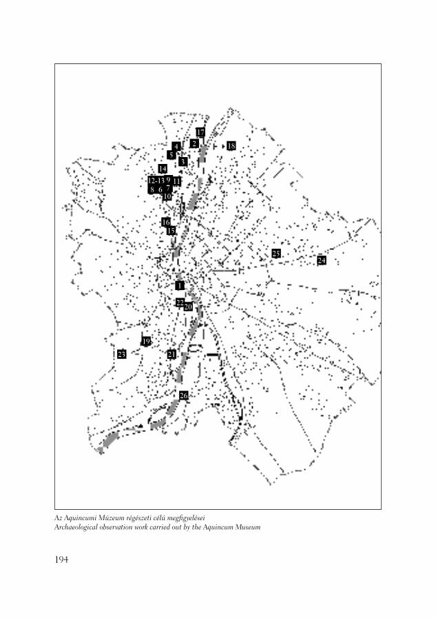
194
Az Aquincumi Múzeum régészeti célú megfi gyeléseiArchaeological observation work carried out by the Aquincum Museum
1
2
3
45
6 789
10
1112-13
14
1516
17
18
19
2220
2123
2425
26
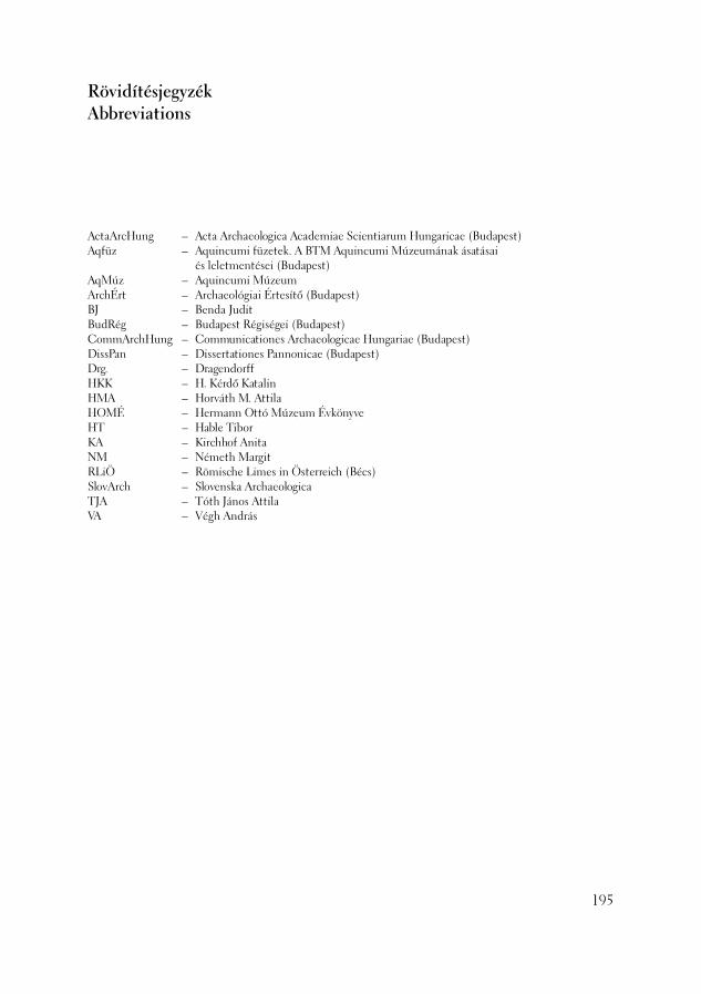
ActaArcHung – Acta Archaeologica Academiae Scientiarum Hungaricae (Budapest)Aqfüz – Aquincumi füzetek. A BTM Aquincumi Múzeumának ásatásai
és leletmentései (Budapest)AqMúz – Aquincumi MúzeumArchÉrt – Archaeológiai Értesítő (Budapest)BJ – Benda JuditBudRég – Budapest Régiségei (Budapest)CommArchHung – Communicationes Archaeologicae Hungariae (Budapest)DissPan – Dissertationes Pannonicae (Budapest)Drg. – DragendorffHKK – H. Kérdő KatalinHMA – Horváth M. AttilaHOMÉ – Hermann Ottó Múzeum ÉvkönyveHT – Hable TiborKA – Kirchhof AnitaNM – Németh MargitRLiÖ – Römische Limes in Österreich (Bécs)SlovArch – Slovenska Archaeologica TJA – Tóth János AttilaVA – Végh András
RövidítésjegyzékAbbreviations
195

Alibán András – geodétaAnderkó Krisztián (BTM Aquincumi Múzeum)
– ásatási technikusAschenbrenner Károly – rajzolóBakos Margit (BTM) – fotósBalogh Roland (ELTE) – régészhallgatóBartus Dávid (ELTE) – régészhallgatóBáthori Gábor – régészBertalan Balázs – tanuló Beszédes József (BTM Aquincumi Múzeum) – régészBiró Csaba – egyetemi hallgatóBogdándy Kornélia – technikusBudai Balogh Tibor (BTM Aquincumi Múzeum)
– régészBusi György (BTM Aquincumi Múzeum) – geodétaCzifra Szabolcs (ELTE) – régész hallgatóCserne Lászlóné (BTM Ős- és Népvándorlás kori
Osztály) – rajzolóDarvas Noémi – egyetemi hallgatóDezső Dóra – technikusDittera Károly – rajzolóDaróczi-Szabó László – régész, archaeozoológusEndrődi Anna (BTM Ős- és Népvándorlás kori
Osztály) – régészR. Facsády Annamária (BTM Aquincumi Múzeum)
– régészGardánfalvi Magdolna – technikusGerendai Rudolf – technikusGyörkő Anikó – egyetemi hallgatóGyőri Búvár Sportegyesület – búvár asszisztenciaGyőző Eszter – technikusHable Tibor (BTM Aquincumi Múzeum) – régészHarsányi István – építészHeinz Katalin (BTM Restaurátor Osztály)
– restaurátorHorváth M. Attila(BTM Ős- és Népvándorlás kori
Osztály) – régészHorváth László András (BTM Ős- és Népvándorlás
kori Osztály) – régészHorváth Zoltán (ELTE Alkalmazott és
Környezetföldtani Tanszék) – geológusIsabelle Marthot (Sorbonne) – régészhallgatóJakab Attila – egyetemi hallgatóJankovics Norbert – egyetemi hallgató
A 2003. évi feltárások közreműködőiParticipants in the Excavations in 2003
András Alibán – geodesyKrisztián Anderkó (BHM Aquincum Museum)
– technicianKároly Aschenbrenner – technical drawingMargit Bakos (BHM) – photographerRoland Balogh (ELTE) – university studentDávid Bartus (ELTE) – university studentGábor Báthori – archaeologistBalázs Bertalan – studentJózsef Beszédes (BHM Aquincum Museum)
– archaeologistCsaba Biró – university studentKornélia Bogdándy – technicianTibor Budai Balogh (BHM Aquincum Museum)
– archaeologistGyörgy Busi (BHM Aquincum Museum) – geodesySzabolcs Czifra (ELTE) – university studentLászlóné Cserne (BHM Dept. of Prehistory and
Protohistory) – technical drawingNoémi Darvas – university studentDóra Dezső – technicianKároly Dittera – technical drawingLászló Daróczi-Szabó – archaeologist,
archaeozoologistAnna Endrődi (BHM Dept. of Prehistory and
Protohistory) – archaeologistAnnamária R. Facsády (BHM Aquincum Museum)
– archaeologistMagdolna Gardánfalvi – technicianRudolf Gerendai – technicianAnikó Györkő – university studentGyőr Diving Association – diving assistencyGyőző Eszter – technicianTibor Hable (BHM Aquincum Museum)
– archaeologistIstván Harsányi – architectKatalin Heinz (BHM Dept. of Restoration)
– restorerAttila Horváth M. (BHM Dept. of Prehistory and
Protohistory) – archaeologistAndrás László Horváth (BHM Dept. of Prehistory
and Protohistory) – archaeologistZoltán Horváth (ELTE) – geologistMarthot Isabelle (Sorbonne) – university student
196

Jóri Tünde – technikusKalász Nándor – tanárKecskés Anita – régész hallgatóH. Kérdő Katalin (BTM Aquincumi Múzeum)
– régészKirchhof Anita (BTM Aquincumi Múzeum) – régészKisjuhász Viktória (ELTE) – régész hallgatóKiss Attila – műszaki ellenőrKiss Bertalan – technikusKiss Csaba (ELTE) – régészhallgatóKomjáthy Péter (BTM Aquincumi Múzeum) – fotóKondorosy Szabolcs – egyetemi hallgatóKoós István – régészKovács Tibor (BTM Aquincumi Múzeum)
– geodéziaKrolopp Endre (Magyar Állami Földtani Intézet)
– paleontológusLabancz Károly – műszaki ellenőrLaczkó Mariann (BTM Ős- és Népvándorlás kori
Osztály) – rajzolóT. Láng Orsolya (BTM Aquincumi Múzeum)
– régészLassányi Gábor (BTM Aquincumi Múzeum)
– régész, egyiptológusLászló Orsolya – technikusLebegyev Judit – régészLészkó Ildikó (BTM Restaurátor Osztály)
– restaurátorLichtenberger Endre – statikusMadarassy Orsolya (BTM Aquincumi Múzeum)
– régészMálik Éva (BTM Aquincumi Múzeum) – rajzolóMaráz Borbála(BTM Ős- és Népvándorlás kori
Osztály) – régészMárton András – régészMerkl Máté – technikusMindszenty Andrea (ELTE Alkalmazott és
Környezetföldtani Tanszék) – geológusNagy Tamás – egyetemi hallgatóNémeth Margit (BTM Aquincumi Múzeum)
– régészMolnár Attila – szerződéses régészNagy Alexandra (BTM Aquincumi Múzeum)
– technikusNemes György – technikusOláh Beatrix (BTM Aquincumi Múzeum)
– technikusPapp Adrienn – szerződéses régészPuzsér Róbert – technikusReményi László (BTM Ős- és Népvándorlás kori
Osztály) – régészReményi Tamás – restaurátorSárosi Edit – régészSey Nikoletta (ELTE) – régészhallgató
Attila Jakab – university studentNorbert Jankovics – university studentTünde Jóri – technicianNándor Kalász – teacherAnita Kecskés – university studentKatalin H. Kérdő (BHM Aquincum Museum)
– archaeologistAnita Kirchhof (BHM Aquincum Museum)
– archaeologistViktória Kisjuhász (ELTE) – university studentAttila Kiss – technical supervisorBertalan Kiss – technicianCsaba Kiss (ELTE) – university studentPéter Komjáthy (BHM Aquincum Museum)
– photographerSzabolcs Kondorosy – university studentIstván Koós – archaeologistTibor Kovács (BHM Aquincum Museum) – geodesyEndre Krolopp (Geological Institute of Hungary)
– paleontologistKároly Labancz – technical supervisorMariann Laczkó (BHM Dept. of Prehistory and
Protohistory) – technical drawingOrsolya T. Láng (BHM Aquincum Museum)
– archaeologistGábor Lassányi (BHM Aquincum Museum)
– archaeologist, egyiptologistOrsolya László – technicianJudit Lebegyev – archaeologistIldikó Lészkó (BHM Dept. of Restoration) – restorerEndre Lichtenberger – structural engineerOrsolya Madarassy (BHM Aquincum Museum)
– archaeologistÉva Málik (BHM Aquincum Museum) – technical
drawingBorbála Maráz (BHM Dept. of Prehistory and
Protohistory) – archaeologistAndrás Márton – archaeologistMáté Merkl – technicianAndrea Mindszenty (ELTE) – geologistTamás Nagy – university studentMargit Németh (BHM Aquincum Museum)
– archaeologistAttila Molnár – archaeologistAlexandra Nagy (BHM Aquincum Museum)
– technicianGyörgy Nemes – technicianBeatrix Oláh (BHM Aquincum Museum)
– technicianAdrienn Papp – archaeologistRóbert Puzsér – technicianLászló Reményi (BHM Dept. of Prehistory and
Protohistory) – archaeologistTamás Reményi – restorer
197
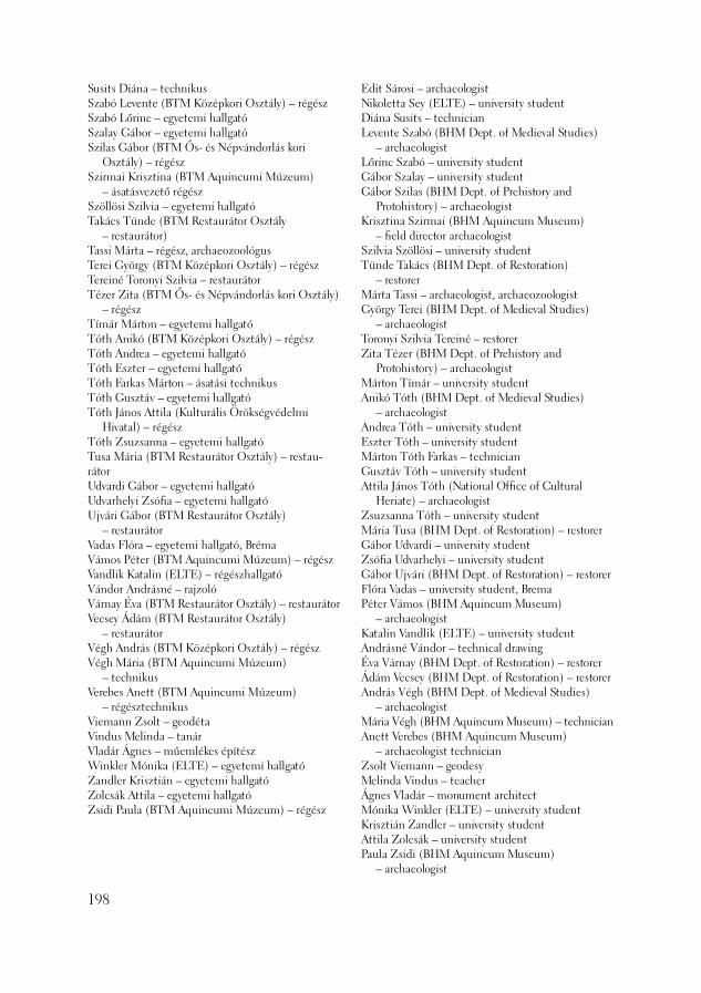
Susits Diána – technikusSzabó Levente (BTM Középkori Osztály) – régészSzabó Lőrinc – egyetemi hallgatóSzalay Gábor – egyetemi hallgatóSzilas Gábor (BTM Ős- és Népvándorlás kori
Osztály) – régészSzirmai Krisztina (BTM Aquincumi Múzeum)
– ásatásvezető régészSzöllösi Szilvia – egyetemi hallgatóTakács Tünde (BTM Restaurátor Osztály
– restaurátor) Tassi Márta – régész, archaeozoológusTerei György (BTM Középkori Osztály) – régészTereiné Toronyi Szilvia – restaurátorTézer Zita (BTM Ős- és Népvándorlás kori Osztály)
– régészTímár Márton – egyetemi hallgatóTóth Anikó (BTM Középkori Osztály) – régészTóth Andrea – egyetemi hallgatóTóth Eszter – egyetemi hallgatóTóth Farkas Márton – ásatási technikusTóth Gusztáv – egyetemi hallgatóTóth János Attila (Kulturális Örökségvédelmi
Hivatal) – régészTóth Zsuzsanna – egyetemi hallgatóTusa Mária (BTM Restaurátor Osztály) – restau-rátorUdvardi Gábor – egyetemi hallgatóUdvarhelyi Zsófi a – egyetemi hallgatóUjvári Gábor (BTM Restaurátor Osztály)
– restaurátorVadas Flóra – egyetemi hallgató, BrémaVámos Péter (BTM Aquincumi Múzeum) – régészVandlik Katalin (ELTE) – régészhallgatóVándor Andrásné – rajzolóVárnay Éva (BTM Restaurátor Osztály) – restaurátorVecsey Ádám (BTM Restaurátor Osztály)
– restaurátorVégh András (BTM Középkori Osztály) – régészVégh Mária (BTM Aquincumi Múzeum)
– technikusVerebes Anett (BTM Aquincumi Múzeum)
– régésztechnikusViemann Zsolt – geodétaVindus Melinda – tanárVladár Ágnes – műemlékes építészWinkler Mónika (ELTE) – egyetemi hallgatóZandler Krisztián – egyetemi hallgatóZolcsák Attila – egyetemi hallgatóZsidi Paula (BTM Aquincumi Múzeum) – régész
Edit Sárosi – archaeologistNikoletta Sey (ELTE) – university studentDiána Susits – technicianLevente Szabó (BHM Dept. of Medieval Studies)
– archaeologistLőrinc Szabó – university studentGábor Szalay – university studentGábor Szilas (BHM Dept. of Prehistory and
Protohistory) – archaeologistKrisztina Szirmai (BHM Aquincum Museum)
– fi eld director archaeologistSzilvia Szöllösi – university studentTünde Takács (BHM Dept. of Restoration)
– restorerMárta Tassi – archaeologist, archaeozoologistGyörgy Terei (BHM Dept. of Medieval Studies)
– archaeologistToronyi Szilvia Tereiné – restorerZita Tézer (BHM Dept. of Prehistory and
Protohistory) – archaeologistMárton Tímár – university studentAnikó Tóth (BHM Dept. of Medieval Studies)
– archaeologistAndrea Tóth – university studentEszter Tóth – university studentMárton Tóth Farkas – technicianGusztáv Tóth – university studentAttila János Tóth (National Offi ce of Cultural
Heriate) – archaeologistZsuzsanna Tóth – university studentMária Tusa (BHM Dept. of Restoration) – restorerGábor Udvardi – university studentZsófi a Udvarhelyi – university studentGábor Ujvári (BHM Dept. of Restoration) – restorerFlóra Vadas – university student, BremaPéter Vámos (BHM Aquincum Museum)
– archaeologistKatalin Vandlik (ELTE) – university studentAndrásné Vándor – technical drawingÉva Várnay (BHM Dept. of Restoration) – restorerÁdám Vecsey (BHM Dept. of Restoration) – restorerAndrás Végh (BHM Dept. of Medieval Studies)
– archaeologistMária Végh (BHM Aquincum Museum) – technicianAnett Verebes (BHM Aquincum Museum)
– archaeologist technicianZsolt Viemann – geodesyMelinda Vindus – teacherÁgnes Vladár – monument architectMónika Winkler (ELTE) – university studentKrisztián Zandler – university studentAttila Zolcsák – university studentPaula Zsidi (BHM Aquincum Museum)
– archaeologist
198
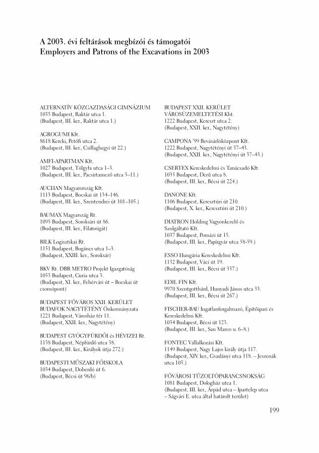
ALTERNATÍV KÖZGAZDASÁGI GIMNÁZIUM1035 Budapest, Raktár utca 1.(Budapest, III. ker., Raktár utca 1.)
AGROGUMI Kft.8618 Kereki, Petőfi utca 2.(Budapest, III. ker., Csillaghegyi út 22.)
AMFI-APARTMAN Kft.1027 Budapest, Tölgyfa utca 1–3.(Budapest, III. ker., Pacsirtamező utca 3–11.)
AUCHAN Magyarország Kft.1113 Budapest, Bocskai út 134–146.(Budapest, III. ker., Szentendrei út 101–105.)
BAUMAX Magyarszág Rt.1095 Budapest, Soroksári út 86.(Budapest, III. ker., Filatorigát)
BILK Logisztikai Rt.1151 Budapest, Bogáncs utca 1–3.(Budapest, XXIII. ker., Soroksár)
BKV Rt. DBR METRO Projekt Igazgatóság1053 Budapest, Curia utca 3.(Budapest, XI. ker., Fehérvári út – Bocskai út csomópont)
BUDAPEST FŐVÁROS XXII. KERÜLET BUDAFOK NAGYTÉTÉNY Önkormányzata1221 Budapest, Városház tér 11.(Budapest, XXII. ker., Nagytétény)
BUDAPEST GYÓGYFÜRDŐI és HÉVIZEI Rt.1138 Budapest, Népfürdő utca 38.(Budapest, III. ker., Királyok útja 272.)
BUDAPESTI MŰSZAKI FŐISKOLA1034 Budapest, Doberdó út 6.(Budapest, Bécsi út 96/b)
A 2003. évi feltárások megbízói és támogatóiEmployers and Patrons of the Excavations in 2003
BUDAPEST XXII. KERÜLET VÁROSÜZEMELTETÉSI Kht.1222 Budapest, Kereszt utca 2.(Budapest, XXII. ker., Nagytétény)
CAMPONA ’99 Bevásárlóközpont Kft.1222 Budapest, Nagytétényi út 37–43.(Budapest, XXII. ker., Nagytétényi út 37–43.)
CSERTEX Kereskedelmi és Tanácsadó Kft.1035 Budapest, Derű utca 8.(Budapest, III. ker., Bécsi út 224.)
DANONE Kft.1106 Budapest, Keresztúri út 210.(Budapest, X. ker., Keresztúri út 210.)
DIATRON Holding Vagyonkezelő ésSzolgáltató Kft.1037 Budapest, Pomázi út 15.(Budapest, III. ker., Papírgyár utca 58-59.)
ESSO Hungária Kereskedelmi Kft.1132 Budapest, Váci út 19.(Budapest, III. ker., Bécsi út 337.)
EDIL FIN Kft.9970 Szentgotthárd, Hunyadi János utca 33.(Budapest, III. ker., Bécsi út 267.)
FISCHER-BAU Ingatlanforgalmazó, Építőipari és Kereskedelmi Kft.1034 Budapest, Bécsi út 123.(Budapest, III. ker., San Marco u. 6–8.)
FONTEC Vállalkozási Kft.1149 Budapest, Nagy Lajos király útja 117.(Budapest, XIV. ker., Gvadányi utca 118. – Jeszenák utca 105.)
FŐVÁROSI TŰZOLTÓPARANCSNOKSÁG1081 Budapest, Dologház utca 1.(Budapest, III. ker., Árpád utca – Ipartelep utca – Ságvári E. utca által határolt terület)
199
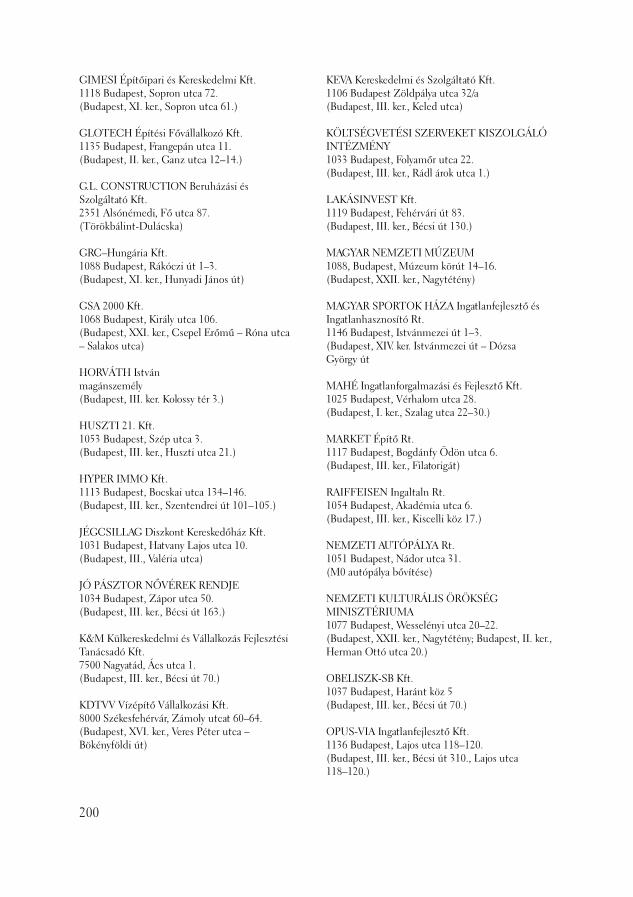
GIMESI Építőipari és Kereskedelmi Kft.1118 Budapest, Sopron utca 72.(Budapest, XI. ker., Sopron utca 61.)
GLOTECH Építési Fővállalkozó Kft.1135 Budapest, Frangepán utca 11.(Budapest, II. ker., Ganz utca 12–14.)
G.L. CONSTRUCTION Beruházási és Szolgáltató Kft.2351 Alsónémedi, Fő utca 87.(Törökbálint-Dulácska)
GRC–Hungária Kft.1088 Budapest, Rákóczi út 1–3.(Budapest, XI. ker., Hunyadi János út)
GSA 2000 Kft.1068 Budapest, Király utca 106.(Budapest, XXI. ker., Csepel Erőmű – Róna utca – Salakos utca)
HORVÁTH Istvánmagánszemély(Budapest, III. ker. Kolossy tér 3.)
HUSZTI 21. Kft.1053 Budapest, Szép utca 3.(Budapest, III. ker., Huszti utca 21.)
HYPER IMMO Kft.1113 Budapest, Bocskai utca 134–146.(Budapest, III. ker., Szentendrei út 101–105.)
JÉGCSILLAG Diszkont Kereskedőház Kft.1031 Budapest, Hatvany Lajos utca 10.(Budapest, III., Valéria utca)
JÓ PÁSZTOR NŐVÉREK RENDJE1034 Budapest, Zápor utca 50.(Budapest, III. ker., Bécsi út 163.)
K&M Külkereskedelmi és Vállalkozás Fejlesztési Tanácsadó Kft.7500 Nagyatád, Ács utca 1.(Budapest, III. ker., Bécsi út 70.)
KDTVV Vízépítő Vállalkozási Kft.8000 Székesfehérvár, Zámoly utcat 60–64.(Budapest, XVI. ker., Veres Péter utca –Bökényföldi út)
KEVA Kereskedelmi és Szolgáltató Kft.1106 Budapest Zöldpálya utca 32/a(Budapest, III. ker., Keled utca)
KÖLTSÉGVETÉSI SZERVEKET KISZOLGÁLÓ INTÉZMÉNY1033 Budapest, Folyamőr utca 22.(Budapest, III. ker., Rádl árok utca 1.)
LAKÁSINVEST Kft.1119 Budapest, Fehérvári út 83. (Budapest, III. ker., Bécsi út 130.)
MAGYAR NEMZETI MÚZEUM1088, Budapest, Múzeum körút 14–16.(Budapest, XXII. ker., Nagytétény)
MAGYAR SPORTOK HÁZA Ingatlanfejlesztő és Ingatlanhasznosító Rt.1146 Budapest, Istvánmezei út 1–3.(Budapest, XIV. ker. Istvánmezei út – Dózsa György út
MAHÉ Ingatlanforgalmazási és Fejlesztő Kft.1025 Budapest, Vérhalom utca 28.(Budapest, I. ker., Szalag utca 22–30.)
MARKET Építő Rt.1117 Budapest, Bogdánfy Ödön utca 6.(Budapest, III. ker., Filatorigát)
RAIFFEISEN Ingaltaln Rt.1054 Budapest, Akadémia utca 6.(Budapest, III. ker., Kiscelli köz 17.)
NEMZETI AUTÓPÁLYA Rt.1051 Budapest, Nádor utca 31.(M0 autópálya bővítése)
NEMZETI KULTURÁLIS ÖRÖKSÉG MINISZTÉRIUMA1077 Budapest, Wesselényi utca 20–22.(Budapest, XXII. ker., Nagytétény; Budapest, II. ker., Herman Ottó utca 20.)
OBELISZK-SB Kft.1037 Budapest, Haránt köz 5(Budapest, III. ker., Bécsi út 70.)
OPUS-VIA Ingatlanfejlesztő Kft.1136 Budapest, Lajos utca 118–120.(Budapest, III. ker., Bécsi út 310., Lajos utca 118–120.)
200
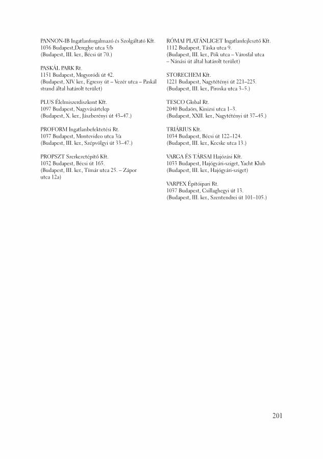
PANNON-IB Ingatlanforgalmazó és Szolgáltató Kft.1036 Budapest,Dereglye utca 5/b(Budapest, III. ker., Bécsi út 70.)
PASKÁL PARK Rt.1151 Budapest, Mogyoródi út 42.(Budapest, XIV. ker., Egressy út – Vezér utca – Paskál strand által határolt terület)
PLUS Élelmiszerdiszkont Kft.1097 Budapest, Nagyvásártelep(Budapest, X. ker., Jászberényi út 43–47.)
PROFORM Ingatlanbefektetési Rt.1037 Budapest, Montevideo utca 3/a(Budapest, III. ker., Szépvölgyi út 33–47.)
PROPSZT Szerkezetépítő Kft.1032 Budapest, Bécsi út 165.(Budapest, III. ker., Tímár utca 25. – Zápor utca 12a)
RÓMAI PLATÁNLIGET Ingatlanfejlesztő Kft.1112 Budapest, Táska utca 9.(Budapest, III. ker., Pók utca – Városfal utca – Nánási út által határolt terület)
STORECHEM Kft.1221 Budapest, Nagytétényi út 221–225.(Budapest, III. ker., Piroska utca 3–5.)
TESCO Global Rt.2040 Budaörs, Kinizsi utca 1–3.(Budapest, XXII. ker., Nagytétényi út 37–45.)
TRIÁRIUS Kft.1034 Budapest, Bécsi út 122–124.(Budapest, III. ker., Kecske utca 13.)
VARGA ÉS TÁRSAI Hajózási Kft.1033 Budapest, Hajógyári-sziget, Yacht Klub(Budapest, III. ker., Hajógyári-sziget)
VARPEX Építóipari Rt.1037 Budapest, Csillaghegyi út 13.(Budapest, III. ker., Szentendrei út 101–105.)
201
A BTM Aquincumi Múzeumának és munkatársainak 2003-ban megjelent publikációiPublications by the Staff of the Aquincum Museum in 2003
(Összállították:Gali Ágnes és Hanny Erzsébet)(Compiled by Ágnes Gali and Erzsébet Hanny)
202
Aquincumi Füzetek 9. Aquincum : A BTM Aquincumi Múzeumának ásatásai és leletmentései 2002–ben = Excavations and rescue work at the Aquincum Museum in 2002 / szerk. Zsidi Paula. – Budapest : BTM, 2003. – 226 p. : ill. ; 20 cm. – (Aquincumi füzetek, ISSN 1219–4919, ISSN 1219 9427 ; 9.)
Aquincum. Rimania v Budapešti = Aquincum. A rómaiak Budapesten : Rekonštrukcie, makety a pred-mety z praveku, z doby rímskej a z doby st´ahovania národov = Őskori, római kori és népvándorlás kori tárgyak, épület rekonstrukciók és makettek : Východoslovenské múzeum Košice, 23. október 2003 – 26. január 2004, Mestské múzeum Bratislava, 19. február 2004 – 18. apríl 2004 / [ed. Paula Zsidi, Annamá-ria Facsády, Anna Endrődi] ; [texty Paula Zsidi, Anna Endrődi, László András Horváth, Borbála Maráz, Gábor Szilas]. – Budapest : BTM, 2003. – 83 p. : ill. ; 24 cm
Forschungen in Aquincum 1969–2002. Zu Ehren von Klára Póczy = Clarae Póczy Octogenariae / szerk. Paula Zsidi. – Budapest : BTM, 2003. – 404 p. : ill. ; 24. cm. – (Aquincum Nostrum, ISSN 1785 0339 ; II. 2.)
BESZÉDES JózsefAuswertung der Steindenkmäler von Bölcske. In: Bölcske. Römische Inschriften und Funde / Hrsg. Á
Szabó, E. Tóth. – Budapest : MNM, 2003. – (Libelli Archaeologici. Ser. Nov., 2.). – p. 283–328.A Budapest, XI. ker., Bartók Béla út – Fehérvári út felszíni rendezéséhez kapcsolódó régészeti feltárá-
sok és megfi gyelések 2002-ben / – –, Terei György. In: Aquincum : A BTM Aquincumi Múzeumának ásatásai és leletmentései 2002-ben. – Bp. : BTM, 2003. – (Aquincumi füzetek, ISSN 1219-9427 ; 9.). – p. 194-196.
Budapest, XI. ker., Pannonhalmi út 18. In: Aquincum : A BTM Aquincumi Múzeumának ásatásai és lelet-mentései 2002-ben. – Bp. : BTM, 2003. – (Aquincumi füzetek ; 9.). – p. 198.
Die Grabsteine der legio XV Apollinaris in Carnuntum / – –, M. Mosser. In: Carnuntum Jahrbuch 2003, p. 9–98.
Die Steindenkmäler von Bölcske – Inschriften und Skulpturen – Katalog / – –, Zs. Mráv, E. Tóth. In: Bölcske. Römische Inschriften und Funde / Hrsg. Á Szabó, E. Tóth. – Budapest : MNM, 2003. – (Libel-li Archaeologici Ser. Nov., 2.). – p. 103–218.
Újabb topográfi ai adatok a Szent Gellért tér őskori, római és középkori beépítettségéhez = Recent topographic data on prehistoric, Roman and medieval settlements in Szent Gellért Square / – –, Terei György. In: Aquincum : A BTM Aquincumi Múzeumának ásatásai és leletmentései 2002-ben. – Bp. : BTM, 2003. – (Aquincumi füzetek ; 9.). – p. 131–145.
ásatási jelentések:Paks, Dunakömlőd, Bottyán-sánc (Sánchegy), római vicus. In: Régészeti kutatások Magyarországon 2000
(2003), p. 188–189.
CHOYKE AliceAnimals and Roman lifeways in Aquincum. In: Forschungen in Aquincum 1969–2002 : Zu Ehren von
Klára Póczy. Clarae Póczy Octogenariae / [red. Paula Zsidi]. – Bp. : BTM, 2003. – (Aquincum Nostrum II. ; 2.). – p. 210–230.
203
Archaeozoology and the transition from socialism to capitalism: the case of Roman Aquincum. In: Ar-chaeozoology, wildlife conservation and heritage management / eds. R.C.G.M. Lauwertier and I. Plug. – Oxford, 2003. – (Oxbow books)
Backward refl ections on ancient environments: What we can learn from bone tools. In: People and nature in historical perspective. / eds. J. Laszlovszky, P. Szabó. –, Budapest : CEU Medievalia, 2003. – p. 139–156.
Levels of social identity expressed in the refuse and worked bone from the Middle Bronze Age Százhalom-batta-Földvár, Vatya culture, Hungary / – –, M. Vretemark, S. Sten. In: Behaviour behind bones. The zooarchaeology of ritual, religion. Status and identity / eds. S. Jones O’ Day, W. van Neer, A. Ervynck. – Oxford, 2003. – (Oxbow Books). – p. 177–189.
CSONTOS KatalinCicada brooches on Pannonian stone monuments. In: Pannonica provincialia et archaeologia : Studia sol-
lemnia auctorum hungarorum Eugenio Fitz octogenario dedicata. / Hrsg. Á. Szabó, E. Tóth – Budapest : MNM, 2003. – (Libelli Archaeologici. Ser. Nov.; 1.). – p. 103–112.
Aquincum. Rimania v Budapesti = Aquincum. A rómaiak Budapesten : Rekonštrukcie, makety a pred-mety z praveku, z doby rímskej a z doby st´ahovania národov = Őskori, római kori és népvándorlás kori tárgyak, épület rekonstrukciók és makettek : Východoslovenské múzeum Košice, 23. október 2003 – 26. január 2004, Mestské múzeum Bratislava, 19. február 2004 – 18. apríl 2004 / [ed. Paula Zsidi, – –, Anna Endrődi] ; [texty Paula Zsidi, – –, László András Horváth, Anna Endrődi, Gábor Szilas, Borbála Maráz]. – Bp. : BTM, 2003. – 83 p. : ill. ; 24 cm
ENDRŐDI AnnaAquincum. Rimania v Budapesti = Aquincum. A rómaiak Budapesten : Rekonštrukcie, makety a pred-
mety z praveku, z doby rímskej a z doby st´ahovania národov = Őskori, római kori és népvándorlás kori tárgyak, épület rekonstrukciók és makettek : Východoslovenské múzeum Košice, 23. október 2003 – 26. január 2004, Mestské múzeum Bratislava, 19. február 2004 – 18. apríl 2004 / [ed. Paula Zsidi, Annamá-ria Facsády, – –] ; [texty Paula Zsidi, – –, László András Horváth, Borbála Maráz, Gábor Szilas]. – Bp. : BTM, 2003. – 83 p. : ill. ; 24 cm
Az Albertfalva, 6-os számú főút bővítését megelőző régészeti feltárás eredményei = The results of the excavations preceding the enlargement of route 6 by Albertfalva / – –, Reményi László. In: Aquincum : A BTM Aquincumi Múzeumának ásatásai és leletmentései 2002-ben. – Bp. : BTM, 2003. – (Aquincumi füzetek ; 9.). – p. 146-150.
Előzetes jelentés a Dunakeszi, Székes-dűlőn végzett őskori telepásatásról / Horváth László András, Szilas Gábor, – –, Horváth M. Attila. In: Régészeti kutatások Magyarországon 2000 (2003), p. 5–17.
Kora bronzkori és avar kori sírok Budapest, Csepel-szigeten = Early Bronze Age and Avar graves at Buda-pest, Csepel-Island / – –, Horváth M. Attila. In: Régészeti kutatások Magyarországon 1999. – Bp., 2002. – p. 27–45.
The late phase of the Bell Beaker – Csepel Group in Hungary. In: The Northeast Frontier of Bell Beakers : Proceedings of the symposium held at the Adam Miczkiewicz University, Poznan (Poland), May 26–29. 2002 / ed. by Janusz Czebreszuk, Marzena Szmyt. – Oxford, 2003. – (BAR International Series ; 1155). – p. 265–276.
Ein neues spätkupferzeitliches Idolbruchstück aus Budapest. Gedanken über die Erscheinungen des reli-giösen Lebens. In: Morgenrot der Kulturen : Frühe Etappen der Menschheitsgeschichte in Mittel- und Südosteuropa : Festschrift für Nándor Kalicz zum 75 Geburtstag / Hrsg. von Erzsébet Jerem, Pál Raczky. – Budapest : Archaeolingua Alap., 2003. – (Archaeolingua ; 15.). – p. 401–414.
Technological study of Beaker metallurgy in Hungary. / Endrődi, A., – –, Baradács, E., Uzonyi, I., Kiss, A. Z., Montero, I., Rovira, S. In: Archaeometalurgy in Europe, proceedings Vol. 2. Associazione Italiana di Metalurgia. Milan (2003) – p. 29–38.
FACSÁDY AnnamáriaAquincum. Rimania v Budapesti = Aquincum. A rómaiak Budapesten : Rekonštrukcie, makety a pred-
mety z praveku, z doby rímskej a z doby st´ahovania národov = Őskori, római kori és népvándorlás kori

204
tárgyak, épület rekonstrukciók és makettek : Východoslovenské múzeum Košice, 23. október 2003 – 26. január 2004, Mestské múzeum Bratislava, 19. február 2004 – 18. apríl 2004 / [ed. Paula Zsidi, – –, Anna Endrődi] ; [texty Paula Zsidi, – –, László András Horváth, Anna Endrődi, Gábor Szilas, Borbála Maráz]. – Bp. : BTM, 2003. – 83 p. : ill. ; 24 cm
Aquincum – a rómaiak Budapesten : A Budapesti Történeti Múzeum időszaki kiállítása Kassán, 2003. októ-ber 23 – 2004. január 26. In: Múzeumi hírlevél 24. évf. 11. sz. (2003. nov.), p. 347–348.
Az aquincumi éremleletek feldolgozásának problémái / – –, Redő Ferenc. In: A numizmatika és a társtudo-mányok IV. : Konferencia Esztergomban, 1999. október 1–3. / szerk. Torbágyi Melinda. – Bp., 2003. – p. 43–51.
Geldumlauf in Aquincum. In: Forschungen in Aquincum 1969–2002 : Zu Ehren von Klára Póczy. Clarae Póczy Octogenariae / [red. Paula Zsidi]. – Bp. : BTM, 2003. – (Aquincum Nostrum II. ; 2.). – p. 207–209.
Herennius Etruscus basis in Budaújlak. In: Pannonica provincialia et archaeologica : Studia sollemnia auctorum hungarorum Eugenio Fitz octogenario dedicata. / Hrsg. Á. Szabó, E. Tóth – Budapest : MNM, 2003. – (Libelli Archaeologici. Ser. Nov.; 1.). – p. 243–248.
Les formes et les techniques de fabrication des bijoux d’or d’Aquincum. In: I bronzi antichi : Produzione e tecnologia / a cura di Alessandra Giumlia-Mair. – Montagnac : Ed. Monique Mergoil, 2002. – (Monog-raphies instrumentum ; 21.). – p. 517–524.
Panoniai ékszerek 5. : Hajdíszek, ruhakapcsoló tűk. In: Ékszer Magazin 10. (2003), p. 42–45.Régészeti feltárás Budaújlak II. kerületi részén (Budapest, II. ker., Lajos utca 18–20., Bécsi út 17–19–21.,
Hrsz.: 14801/0, 14801/1, 14799). In: Aquincum : A BTM Aquincumi Múzeumának ásatásai és leletmen-tései 2002-ben. – Bp. : BTM, 2003. – (Aquincumi füzetek ; 9.). – p. 192-193.
Római ékszerek In: Ókor 2. évf.4. sz. (2003), p. 31–37.Római kori „pénzes” ékszerek. In: Ékszer Magazin 11. (2003), p. 24–28.Szondázás a Bécsi úti temető északi részén = Test excavation in the northern part of the cemetery on
Bécsi Road. In: Aquincum : A BTM Aquincumi Múzeumának ásatásai és leletmentései 2002-ben. – Bp. : BTM, 2003. – (Aquincumi füzetek ; 9.). – p. 65–68.
Válogatás a 2001. év leleteiből . Időszaki kiállítás az Aqincumi Múzeumban. In: Közönség és kapcsolat 2002-2003 (2003), p. 4.
ásatási jelentések:Budapest, III. Dugovics Titusz tér 13–17. / – –, Gyuricza Anna. In: Régészeti kutatások Magyarországon
2000 (2003), p. 110-111.
HABLE TiborAquincum vor der römischen Eroberung. In: Forschungen in Aquincum 1969–2002 : Zu Ehren von Klára
Póczy. Clarae Póczy Octogenariae / [red. Paula Zsidi]. – Bp. : BTM, 2003. – (Aquincum Nostrum II. ; 2.). – p. 49–53.
Két ásatás – az aquincumi canabae déli szélén = Two excavations in the southern part of the Aquincum ca-nabae / – –, Reményi László, Kárpáti Zoltán. In: Aquincum : A BTM Aquincumi Múzeumának ásatásai és leletmentései 2002-ben. – Bp. : BTM, 2003. – (Aquincumi füzetek ; 9.). – p. 33-52.
ásatási jelentések:Budapest, III. Bécsi út 62. In: Régészeti kutatások Magyarországon 2000 (2003), p. 108-109.Budapest, III. Bécsi út 80. In: Régészeti kutatások Magyarországon 2000 (2003), p. 109-110.
HORVÁTH László AndrásAquincum. Rimania v Budapesti = Aquincum. A rómaiak Budapesten : Rekonštrukcie, makety a pred-
mety z praveku, z doby rímskej a z doby st´ahovania národov = Őskori, római kori és népvándorlás kori tárgyak, épület rekonstrukciók és makettek : Východoslovenské múzeum Košice, 23. október 2003 – 26. január 2004, Mestské múzeum Bratislava, 19. február 2004 – 18. apríl 2004 / [ed. Paula Zsidi, Annamária Facsády, Anna Endrődi] ; [texty Paula Zsidi, Anna Endrődi, – –, Borbála Maráz, Gábor Szilas].]. – Bp. : BTM, 2003. – 83 p. : ill. ; 24 cm

205
Előzetes jelentés a Dunakeszi, Székes-dűlőn végzett őskori telepásatásról / – –, Szilas Gábor, Endrődi Anna, Horváth M. Attila. In: Régészeti kutatások Magyarországon 2000 (2003), p. 5–17.
Das Neolithikum und die Kupferzeit in Südwesttransdanubien : Siedlungsgeschichte und Forschungss-tand / – –, H. Simon Katalin. – Budapest : MNM, 2003. – 253 p, 56 tábla 7 térkép. – (Inventaria Praehistorica Hungariae ; 9.)
Régészeti kutatások az aquincumi canabae nyugati, ipari régiójában = Archaeological investigations in the western, industrial quarters in the Aquincum canabae / kirchhof Anita, – –. In: Aquincum : A BTM Aquincumi Múzeumának ásatásai és leletmentései 2002-ben. – Bp. : BTM, 2003. – (Aquincumi füzetek ; 9.). – p. 53–64.
Rézkori temetkezés a budapest-aquincumi gázgyár mellett. In: Vándorutak – Múzeumi örökség : Tan-ulmányok Bodó Sándor tiszteletére, 60. születésnapja alkalmából / szerk. Viga, Gy, Holló Sz. A., Cs. Schwalm E. – Budapest : Archaeolingua, 2003. – p. 257–263.
A rézkor történeti vázlata (Kr. e. 4500/4400–Kr. e. 2800/2700) / – –, M. Virág Zsuzsanna. In: Magyar rég-észet az ezredfordulón / [főszerk. Visy Zsolt ; szerk. Nagy Mihály]. – Budapest : NKÖM : Teleki László Alapítvány, 2003. – p. 125–127.
Die Siedlung der Balaton-Lasinja-Kultur in Zalaegerszeg–Andráshida, Friedhof (Komitat Zala, Ungarn). In: Antaeus 25 (2002), p. 255–282.
ásatási jelentések:Dunakeszi, Nádas. In: Régészeti kutatások Magyarországon 2000 (2003), p. 129–130.
HORVÁTH M. AttilaBudapest, IV. kerület Székes-nádas dűlő (Hrsz.: 76512/183). In: Aquincum : A BTM Aquincumi Múze-
umának ásatásai és leletmentései 2002-ben. – Bp. : BTM, 2003. – (Aquincumi füzetek ; 9.). – p. 198-199.
Előzetes jelentés a Dunakeszi, Székes-dűlőn végzett őskori telepásatásról / Horváth László András, Szilas Gábor, Endrődi Anna, – –. In: Régészeti kutatások Magyarországon 2000 (2003), – p. 5–17.
Kora bronzkori és avar kori sírok Budapest, Csepel-szigeten = Early Bronze Age and Avar graves at Bu-dapest, Csepel-Island / Endrődi Anna, – –. In: Régészeti kutatások Magyarországon 1999. – Bp., 2002. – p. 27–45.
H. KÉRDŐ KatalinDas Alenlager und Vicus der Víziváros. In: Forschungen in Aquincum 1969–2002 : Zu Ehren von Klára
Póczy. Clarae Póczy Octogenariae / [red. Paula Zsidi]. – Bp. : BTM, 2003. – (Aquincum Nostrum II. ; 2.). – p. 81–84.
Budapest, II. ker., Kapás utca 6–12. (Hrsz.: 13757). In: Aquincum : A BTM Aquincumi Múzeumának ásatásai és leletmentései 2002-ben. – Bp. : BTM, 2003. – (Aquincumi füzetek ; 9.). – p. 193.
Kutatások a feltételezett vízivárosi ala tábor és vicus területén = Investigations in the territory of the possible Víziváros ala fort and vicus / – –, Reményi László. In: Aquincum : A BTM Aquincumi Múzeumának ásatásai és leletmentései 2002-ben. – Bp. : BTM, 2003. – (Aquincumi füzetek ; 9.). – p. 124-130.
Magyarország történeti helységnévtára : Nógrád megye, 1773–1808 / összeáll. és szerk. – – . 1-2. köt. – Bu-dapest ; Salgótarján : Központi Statisztikai Hivatal Könyvtár és Dokumentációs Szolgálat , Nógrád Megyei Levéltár, 2002. [2003] – 549 p. + térk.
Római kori rakpart maradványai a Hajógyári-öbölben / – –, Tóth János Attila. – Budapest : Kulturális Örökségvédelmi Hivatal, 2003. – 16 p. : ill. – (Régészeti értékeink)
Der Statthalterpalast von Aquincum. In: Forschungen in Aquincum 1969–2002 : Zu Ehren von Klára Póczy. Clarae Póczy Octogenariae / [red. Paula Zsidi]. – Bp. : BTM, 2003. – (Aquincum Nostrum II. ; 2.). – p. 112–119.
Újabb régészeti feltárások a II. ker., Tölgyfa utcában = Recent archaeological excavations in Tölgyfa Street / – –, Kovács Eszter, Szilas Gábor. In: Aquincum : A BTM Aquincumi Múzeumának ásatásai és leletmentései 2002-ben. – Bp. : BTM, 2003. – (Aquincumi füzetek ; 9.). – p. 115-123.
206
ásatási jelentések:Budapest II. Kacsa utca 7. / – –, Végh András. In: Régészeti kutatások Magyarországon 2000 (2003), p. 106.Budapest, II. Tölgyfa utca 3. – Henger utca 2. / – –, Kovács Eszter, Szilas Gábor. In: Régészeti kutatások
Magyarországon 2000. – Bp., 2003. – p. 107.
KIRCHHOF AnitaBudapest, III. ker., Pacsirtamező utca 17. (Hrsz.: 17797) / – –, Madarassy Orsolya. In: Aquincum : A BTM
Aquincumi Múzeumának ásatásai és leletmentései 2002-ben. – Bp. : BTM, 2003. – (Aquincumi füzetek ; 9.). – p. 191-192.
Budapest, III. ker., Selmeci utca 17. – Zápor utca 23. (Hrsz.: 17411). In: Aquincum : A BTM Aquincu-mi Múzeumának ásatásai és leletmentései 2002-ben. – Bp. : BTM, 2003. – (Aquincumi füzetek ; 9.). – p. 188–189.
Budapest, III. ker., Selmeci utca 26. (Hrsz.: 17430). In: Aquincum : A BTM Aquincumi Múzeumának ásatá-sai és leletmentései 2002-ben. – Bp. : BTM, 2003. – (Aquincumi füzetek ; 9.). – p. 189-190.
Budapest, III. ker., Selmeci utca 29. (Hrsz.: 17399) / – –, Madarassy Orsolya. In: Aquincum : A BTM Aqu-incumi Múzeumának ásatásai és leletmentései 2002-ben. – Bp. : BTM, 2003. – (Aquincumi füzetek ; 9.). – p. 190-191.
Budapest, III. ker., Tímár utca 24. (Hrsz.: 17622). In: Aquincum : A BTM Aquincumi Múzeumának ásatá-sai és leletmentései 2002-ben. – Bp. : BTM, 2003. – (Aquincumi füzetek ; 9.). – p. 190.
Régészeti kutatások az aquincumi canabae nyugati, ipari régiójában = Archaeological investigations in the western, industrial quarters in the Aquincum canabae / – –, Horváth László András. In: Aquincum : A BTM Aquincumi Múzeumának ásatásai és leletmentései 2002-ben. – Bp. : BTM, 2003. – (Aquincumi füzetek, ISSN 1219-9427 ; 9.). – p. 53–64.
ásatási jelentések:Balatonakali, Ságpuszta. In: Régészeti kutatások Magyarországon 2000 (2003), p. 92.Balatonakali, Temető. In: Régészeti kutatások Magyarországon 2000 (2003), p. 92.
T. LÁNG OrsolyaBudapest, III. ker., Ladik utca 9. (Hrsz.: 19250/8). In: Aquincum : A BTM Aquincumi Múzeumának ásatá-
sai és leletmentései 2002-ben. – Bp. : BTM, 2003. – (Aquincumi füzetek ; 9.). – p. 186-187.Reconsidering the Aquincum macellum: analogies and origins. In: Acta archaeologica 54. (2003), p.
165–204.Régészeti célú terepi megfi gyelések és kisebb megelőző feltárások az aquincumi municipium territóriumán.
In: Aquincum : A BTM Aquincumi Múzeumának ásatásai és leletmentései 2002-ben. – Bp. : BTM, 2003. – (Aquincumi füzetek ; 9.). – p. 197.
Római kori maradványok és késő bronzkori településnyomok Kaszásdűlőn = Remains from the Roman period and Late Bronze Age settlement traces at Kaszásdűlő / – –, Szilas Gábor. In: Aquincum : A BTM Aquincumi Múzeumának ásatásai és leletmentései 2002-ben. – Bp. : BTM, 2003. – (Aquincumi füzetek ; 9.). – p. 111–114.
Római kori útrészletek az aquincumi polgárváros municipális territóriumán (az úgynevezett Testvérhegyi villa környezete) = Roman period road segments in the municipal territory of the Aquincum Civil Town (the environs of the so-called Testvérhegy villa). In: Aquincum : A BTM Aquincumi Múzeumának ásatá-sai és leletmentései 2002-ben. – Bp. : BTM, 2003. – (Aquincumi füzetek ; 9.). – p. 95–110.
Vitae pueorum – Gyermek mindenki (volt) : Egy kiállítás régész szemmel. In: Közönség és kapcsolat 2002-2003 (2003), p. 6-7.
ásatási jelentések:Budapest, III. Sujtás utca, Sujtás és Záhony utca sarka, Sujtás és Keled utca sarka. In: Régészeti kutatások
Magyarországon 2000 (2003), p. 115-116.Budapest, III. Zsófi a utca 7. In: Régészeti kutatások Magyarországon 2000 (2003), p. 118-119.Budapest, III. Római fürdő. In: Régészeti kutatások Magyarországon 2000 (2003), p. 115.

207
LENGYELNÉ KURUCZ KatalinA Berlini Múzeumpedagógiai Szolgálat. In: Országos múzeumi közművelődési konferencia : Esztergom,
2002. június 26–28. / szerk. Lengyelné Kurucz Katalin. – Budapest : Pulszky Társaság, 2003. – p. 26-27.Floralia 2002. In: Közönség és kapcsolat 2002-2003 (2003), p. 10.„Muzsák kertje”. In: Közönség és kapcsolat 2002-2003 (2003), p. 2-3.Országos múzeumi közművelődési konferencia : Esztergom, 2002. június 26–28. / szerk. – -. – Budapest :
Pulszky Társaság, 2003. – 115 p. ; 24 cmRómai lakásbelső rekonstrukció : Időszaki kiállítás az Aquincumi Múzeum „Dirke” védőépületében. In: Kö-
zön ség és kapcsolat 2002-2003 (2003), p. 5.
MADARASSY OrsolyaBudapest, III. ker., Selmeci utca 29. (Hrsz.: 17399) / Kirchhof Anita, – –. In: Aquincum : A BTM Aquin-
cumi Múzeumának ásatásai és leletmentései 2002-ben. – Bp. : BTM, 2003. – (Aquincumi füzetek ; 9.). – p. 190-191.
Budapest, III. ker.,Pacsirtamező utca 17. (Hrsz.: 17797) / Kirchhof Anita, – –. In: Aquincum : A BTM Aquincumi Múzeumának ásatásai és leletmentései 2002-ben. – Bp. : BTM, 2003. – (Aquincumi füzetek ; 9.). – p. 191-192.
Die Canabae legionis. In: Forschungen in Aquincum 1969–2002 : Zu Ehren von Klára Póczy. Clarae Póczy Octogenariae / [red. Paula Zsidi]. – Bp. : BTM, 2003. – (Aquincum Nostrum II. ; 2.). – p. 101–111.
Die Innendekorationen der Gebäude / – –, Paula Zsidi. In: Forschungen in Aquincum 1969–2002 : Zu Ehren von Klára Póczy. Clarae Póczy Octogenariae / [red. Paula Zsidi]. – Bp. : BTM, 2003. – (Aquincum Nostrum II. ; 2.). – p. 245–253.
ásatási jelentések:Budapest, III. Bécsi út 123. In: Régészeti kutatások Magyarországon 2000 (2003), p. 110.Budapest, III. Bécsi út 165. In: Régészeti kutatások Magyarországon 2000 (2003), p. 110.Budapest, III. Bécsi út 173. In: Régészeti kutatások Magyarországon 2000 (2003), p. 110.Budapest, III. Kiscelli utca 74. In: Régészeti kutatások Magyarországon 2000 (2003), p. 112.Budapest, III. Lajos utca 118–120. In: Régészeti kutatások Magyarországon 2000 (2003), p. 113.Budapest, III. Selmeci utca 34. In: Régészeti kutatások Magyarországon 2000 (2003), p. 115.
MARÁZ BorbálaAquincum. Rimania v Budapesti = Aquincum. A rómaiak Budapesten : Rekonštrukcie, makety a pred-
mety z praveku, z doby rímskej a z doby st´ahovania národov = Őskori, római kori és népvándorlás kori tárgyak, épület rekonstrukciók és makettek : Východoslovenské múzeum Košice, 23. október 2003 – 26. január 2004, Mestské múzeum Bratislava, 19. február 2004 – 18. apríl 2004 / [ed. Paula Zsidi, Annamária Facsády, Anna Endrődi] ; [texty Paula Zsidi, Anna Endrődi, László András Horváth, – –, Gábor Szilas].]. – Bp. : BTM, 2003. – 83 p. : ill. ; 24 cm
Budapest, XI. ker., Gellérthegy – Citadella (Hrsz.: 5412). In: Aquincum : A BTM Aquincumi Múzeumának ásatásai és leletmentései 2002-ben. – Bp. : BTM, 2003. – (Aquincumi füzetek ; 9.). – p. 196.
NAGY MargitA gepida sasfejes csatok és kapcsolataik. Die gepidische Adlerschnallen und ihre Beziehungen. In: A Móra
F. Múzeum Évkönyve – Studia Archaeologica 8. (2002), p. 209–243.Hunkori férfi sír Budapest-Zuglóból. In: Vándorutak – Múzeumi örökség : Tanulmányok Bodó Sándor
tiszteletére, 60. születésnapja alkalmából / szerk.: Viga Gy., Holló Sz. A., Cs. Schwalm E. – Budapest : Archaeolingua, 2003. – p. 297–325.
NÉMETH MargitAquincum. Castellum. In: The Roman army in Pannonia / ed. Zsolt Visy. – Bp. : Teleki László Foundation,
2003. – p. 102–104.
208
Aquincum. Castra legionis. In: The Roman army in Pannonia / ed. Zsolt Visy. – Bp. : Teleki László Founda-tion, 2003. – p. 99–101.
Aquincum in der Kaiserzeit. In: Forschungen in Aquincum 1969–2002 : Zu Ehren von Klára Póczy. Clarae Póczy Octogenariae / [red. Paula Zsidi]. – Bp. : BTM, 2003. – (Aquincum Nostrum II. ; 2.). – p. 54–62.
Die Militäranlagen von Óbuda. In: Forschungen in Aquincum 1969–2002 : Zu Ehren von Klára Póczy. Cla-rae Póczy Octogenariae / [red. Paula Zsidi]. – Bp. : BTM, 2003. – (Aquincum Nostrum II. ; 2.). – p. 85–91.
Wachttürme und Festungen am linken Donauufer. In: Forschungen in Aquincum 1969–2002 : Zu Ehren von Klára Póczy. Clarae Póczy Octogenariae / [red. Paula Zsidi]. – Bp. : BTM, 2003. – (Aquincum Nost-rum II. ; 2.). – p. 96–99.
ásatási jelentések:Budapest, III. Hajógyári-sziget. In: Régészeti kutatások Magyarországon 2000 (2003), p. 112.
PÓCZY KláraAmphitheater und Theater. In: Forschungen in Aquincum 1969–2002 : Zu Ehren von Klára Póczy. Clarae
Póczy Octogenariae / [red. Paula Zsidi]. – Bp. : BTM, 2003. – (Aquincum Nostrum II. ; 2.). – p. 259–262.Aquaeductus és a közművesítés. In: Magyar régészet az ezredfordulón / [főszerk. Visy Zsolt ; szerk. Nagy
Mihály]. – Budapest : NKÖM : Teleki László Alapítvány, 2003. – p. 232–235.Das Christentum. In: Forschungen in Aquincum 1969–2002 : Zu Ehren von Klára Póczy. Clarae Póczy
Octogenariae / [red. Paula Zsidi]. – Bp. : BTM, 2003. – (Aquincum Nostrum II. ; 2.). – p. 284–290.Die einheimischen Kulte / – –, Krisztina Szirmai. In: Forschungen in Aquincum 1969–2002 : Zu Ehren von
Klára Póczy. Clarae Póczy Octogenariae / [red. Paula Zsidi]. – Bp. : BTM, 2003. – (Aquincum Nostrum II. ; 2.). – p. 265–268.
Eraviskersiedlungen im Raum Aquincum. In: Forschungen in Aquincum 1969–2002 : Zu Ehren von Klára Póczy. Clarae Póczy Octogenariae / [red. Paula Zsidi]. – Bp. : BTM, 2003. – (Aquincum Nostrum II. ; 2.). – p. 73–79.
Kultuszközpontok Pannoniában. In: Magyar régészet az ezredfordulón / [főszerk. Visy Zsolt ; szerk. Nagy Mihály]. – Budapest : NKÖM : Teleki László Alapítvány, 2003. – p. 247–251.
Lokales Gewerbe und Handel / – –, Paula Zsidi. In: Forschungen in Aquincum 1969–2002 : Zu Ehren von Klára Póczy. Clarae Póczy Octogenariae / [red. Paula Zsidi]. – Bp. : BTM, 2003. – (Aquincum Nostrum II. ; 2.). – p. 185–206.
Schwerpunkt und Charakteristika der Forschungen in Aquincum 1969–2002. In: Forschungen in Aqu-incum 1969–2002 : Zu Ehren von Klára Póczy. Clarae Póczy Octogenariae / [red. Paula Zsidi]. – Bp. : BTM, 2003. – (Aquincum Nostrum II. ; 2.). – p. 33–42.
Une famille d’Aquincum a Rome. In: Pannonica provincialia et archaeologia : Studia sollemnia auctorum hungarorum Eugenio Fitz octogenario dedicata. / Hrsg. Á. Szabó, E. Tóth – Budapest : MNM, 2003. – (Libelli Archaeologici. Ser. Nov.; 1.). – p. 553–562.
Veränderung des Rechtsstatus der Siedlung. In: Forschungen in Aquincum 1969–2002 : Zu Ehren von Klára Póczy. Clarae Póczy Octogenariae / [red. Paula Zsidi]. – Bp. : BTM, 2003. – (Aquincum Nostrum II. ; 2.). – p. 125-126.
Wasserver- und entsorgung, Gebäude des Stadtzentrums. In: Forschungen in Aquincum 1969–2002 : Zu Ehren von Klára Póczy. Clarae Póczy Octogenariae / [red. Paula Zsidi]. – Bp. : BTM, 2003. – (Aquincum Nostrum II. ; 2.). – p. 144–149.
Zur Frage der Kontinuität in Aquincum / – –, Paula Zsidi. In: Forschungen in Aquincum 1969–2002 : Zu Ehren von Klára Póczy. Clarae Póczy Octogenariae / [red. Paula Zsidi]. – Bp. : BTM, 2003. – (Aquincum Nostrum II. ; 2.). – p. 63–69.
PETŐ Mária„Lettera dalla Pannonia”. I dati di Domenico Sestini sulla storia dell’archeologia e del collezionismo in
Ungheria. In: Pannonica provincialia et archaeologia : Studia sollemnia auctorum hungarorum Eugenio Fitz octogenario dedicata. / Hrsg. Á. Szabó, E. Tóth – Budapest : MNM, 2003. – (Libelli Archaeologici. Ser. Nov.; 1.). – p. 563–576.
209
REMÉNYI LászlóA gazdálkodás és életmód kérdései a bronzkori Kárpát-medencében. In: Vándorutak – Múzeumi örökség /
szerk. Viga Gy., Holló Sz., Cs. Schwalm E. – Bp., Archaeolingua, 2003. – p. 267–275.Az Albertfalva, 6-os számú főút bővítését megelőző régészeti feltárás eredményei = The results of the
excavations preceding the enlargement of route 6 by Albertfalva / Endrődi Anna, – –. In: Aquincum : A BTM Aquincumi Múzeumának ásatásai és leletmentései 2002-ben. – Bp. : BTM, 2003. – (Aquincumi füzetek ; 9.). – p. 146-150.
A budai Várhegy bronzkori településtörténete = The History of the Castle Hill Settlements from the Bronze Age in Buda. – –, Hanny Erzsébet. In: Budapest Régiségei 37. Budapest (2003) – p. 237–276.
Duna-parti út részlete és őskori maradványok a polgárvárostól délre = Detail from the road on the Danube bank and prehistoric remains south of the Civil Town / Zsidi Paula, – –. In: Aquincum : A BTM Aquin-cumi Múzeumának ásatásai és leletmentései 2002-ben. – Bp. : BTM, 2003. – (Aquincumi füzetek ; 9.). – p. 86-94.
Két ásatás – az aquincumi canabae déli szélén = Two excavations in the southern part of the Aquincum canabae / hable tibor, – –, kárpáti zoltán. In: Aquincum : A BTM Aquincumi Múzeumának ásatásai és leletmentései 2002-ben. – Bp. : BTM, 2003. – (Aquincumi füzetek ; 9.). – p. 33-52.
Kutatások a feltételezett vízivárosi ala tábor és vicus területén = Investigations in the territory of the pos-sible Víziváros ala fort and vicus / Kérdő Katalin, – –. In: Aquincum : A BTM Aquincumi Múzeumának ásatásai és leletmentései 2002-ben. – Bp. : BTM, 2003. – (Aquincumi füzetek ; 9.). – p. 124-130.
Régészeti és földtani kutatások Soroksár határában = Archaeological and geological investigations in Sor-oksár / Horváth Zoltán, Mindszenty Andrea, – –, Zádor Judit. In: Aquincum : A BTM Aquincumi Múze-umának ásatásai és leletmentései 2002-ben. – Bp. : BTM, 2003. – (Aquincumi füzetek ; 9.). – p. 173–185.
Technological study of Beaker metallurgy in Hungary. / Endrődi, A., – –, Baradács, E., Uzonyi, I., Kiss, A. Z., Montero, I., Rovira, S. In: Archaeometalurgy in Europe, proceedings Vol. 2. Associazione Italiana di Metalurgia. Milan (2003) – p. 29–38.
SZILAS GáborAquincum. Rimania v Budapesti = Aquincum. A rómaiak Budapesten : Rekonštrukcie, makety a pred-
mety z praveku, z doby rímskej a z doby st´ahovania národov = Őskori, római kori és népvándorlás kori tárgyak, épület rekonstrukciók és makettek : Východoslovenské múzeum Košice, 23. október 2003 – 26. január 2004, Mestské múzeum Bratislava, 19. február 2004 – 18. apríl 2004 / [ed. Paula Zsidi, Annamária Facsády, Anna Endrődi] ; [texty Paula Zsidi, Anna Endrődi, László András Horváth, Borbála Maráz, – –]. – Bp. : BTM, 2003. – 83 p. : ill. ; 24 cm
Előzetes jelentés a Dunakeszi, Székes-dűlőn végzett őskori telepásatásról / Horváth László András, – –, Endrődi Anna, Horváth M. Attila. In: Régészeti kutatások Magyarországon 2000. – Bp., 2003. – p. 5–17.
Római kori maradványok és késő bronzkori településnyomok Kaszásdűlőn = Remains from the Roman period and Late Bronze Age settlement traces at Kaszásdűlő / Láng Orsolya, – –. In: Aquincum : A BTM Aquincumi Múzeumának ásatásai és leletmentései 2002-ben. – Bp. : BTM, 2003. – (Aquincumi füzetek ; 9.). – p. 111-114.
Újabb régészeti feltárások a II. ker., Tölgyfa utcában = Recent archaeological excavations in Tölgyfa Street / Kérdő Katalin, Kovács Eszter, – –. In: Aquincum : A BTM Aquincumi Múzeumának ásatásai és lelet-mentései 2002-ben. – Bp. : BTM, 2003. – (Aquincumi füzetek ; 9.). – p. 115-123.
ásatási jelentések:Budapest, II. Tölgyfa utca 3. – Henger utca 2. / H. Kérdő Katalin, Kovács Eszter, – –. In: Régészeti kutatá-
sok Magyarországon 2000 (2003), – p. 107.Budapest, III. Pusztakúti út – Kázmér utca – Valéria utca által határolt terület. In: Régészeti kutatások
Magyarországon 2000 (2003), p. 114-115.
SZIRMAI KrisztinaAlbertfalva castellum. In: The Roman Army in Pannonia. / ed. Zs.Visy. – Bp. : Teleki László Foundation,
2003. – p. l04–106.

210
Auxiliarkastell und Vicus in Albertfalva. In: Forschungen in Aquincum 1969–2002 : Zu Ehren von Klára Póczy. Clarae Póczy Octogenariae / [red. Paula Zsidi]. – Bp. : BTM, 2003. – (Aquincum Nostrum II. ; 2.). – p. 93–95.
Budapest, III. ker., Kórház utca 12. (Hrsz.: 18065/2). In: Aquincum : A BTM Aquincumi Múzeumának ásatásai és leletmentései 2002-ben. – Bp. : BTM, 2003. – (Aquincumi füzetek ; 9.). – p. 187-188.
Budapest, III. ker., Meggyfa utca – Raktár utca között. In: Aquincum : A BTM Aquincumi Múzeumának ásatásai és leletmentései 2002-ben. – Bp. : BTM, 2003. – (Aquincumi füzetek ; 9.). – p. 187.
Budapest, XXII. ker., Zsák utca 5. (Hrsz.: 232412). In: Aquincum : A BTM Aquincumi Múzeumának ásatá-sai és leletmentései 2002-ben. – Bp. : BTM, 2003. – (Aquincumi füzetek ; 9.). – p. 193-194.
Die einheimischen Kulte / Klára Póczy, – –. In: Forschungen in Aquincum 1969–2002 : Zu Ehren von Klára Póczy. Clarae Póczy Octogenariae / [red. Paula Zsidi]. – Bp. : BTM, 2003. – (Aquincum Nostrum II. ; 2.). – p. 265–268.
Military equipment depicted in Aquincum after the Marcomannic wars. In: I bronzi antichi : Produzione e tecnologia / a cura di Alessandra Giumlia-Mair. – Montagnac : Ed. Monique Mergoil, 2002. – (Monog-raphies instrumentum ; 21.). – p. 600–608.
Régészeti megfi gyelések a Belvárosi plébánia templom kisebb, belső rekonstrukciós munkálatainál = Archaeological observations during the small interior reconstruction work at the Belvárosi parish church / – –, Kovács Eszter. In: Aquincum : A BTM Aquincumi Múzeumának ásatásai és leletmentései 2002-ben. – Bp. : BTM, 2003. – (Aquincumi füzetek ; 9.). – p. 162–172.
Römische Götter und der Kaiserkult. In: Forschungen in Aquincum 1969–2002 : Zu Ehren von Klára Póczy. Clarae Póczy Octogenariae / [red. Paula Zsidi]. – Bp. : BTM, 2003. – (Aquincum Nostrum II. ; 2.). – p. 269–273.
Die Steinbearbeitung in Aqincum. In: Forschungen in Aquincum 1969–2002 : Zu Ehren von Klára Póczy. Cla-rae Póczy Octogenariae / [red. Paula Zsidi]. – Bp. : BTM, 2003. – (Aquincum Nostrum II. ; 2.). – p. 233–244.
Új adatok Albertfalva római kori topográfi ájához = New data on the Roman period topography of Albert-falva. In: Aquincum : A BTM Aquincumi Múzeumának ásatásai és leletmentései 2002-ben. – Bp. : BTM, 2003. – (Aquincumi füzetek ; 9.). – p. 151–154.
ásatási jelentések:Budapest, III. Kórház utca 7–9. In: Régészeti kutatások Magyarországon 2000 (2003), p. 113.Budapest, III. Szentendrei út – Kórház utca forgalmi kapcsolat. In: Régészeti kutatások Magyarországon
2000 (2003), p. 117.
SZU AnnamáriaAusstellungen des Aquincum-Museums 1969–2002. In: Forschungen in Aquincum 1969–2002 : Zu Ehren
von Klára Póczy. Clarae Póczy Octogenariae / [red. Paula Zsidi]. – Bp. : BTM, 2003. – (Aquincum Nost-rum II. ; 2.). – p. 370–374.
Új múzeumpedagógiai kiadványkoncepció az Aqincumi Múzeumban. In: Közönség és kapcsolat 2002-2003 (2003), p. 16.
Vitae pueorum – Gyermek mindenki (volt) : Egy kiállítás közönségkapcsolati szemmel. In: Közönség és kapcsolat 2002-2003 (2003), p. 7.
Wissenschaftliche Tätigkeit der Mitarbeiter des Aquincum-Museums 1969–2002. In: Forschungen in Aquincum 1969–2002 : Zu Ehren von Klára Póczy. Clarae Póczy Octogenariae / [red. Paula Zsidi]. – Bp. : BTM, 2003. – (Aquincum Nostrum II. ; 2.). – p. 376–404.
TOPÁL JuditÄgyptische und orientalische Götter und Kulte. In: Forschungen in Aquincum 1969–2002 : Zu Ehren von
Klára Póczy. Clarae Póczy Octogenariae / [red. Paula Zsidi]. – Bp. : BTM, 2003. – (Aquincum Nostrum II. ; 2.). – p. 274–283.
Die Gräberfelder von Aquincum. In: Forschungen in Aquincum 1969–2002 : Zu Ehren von Klára Póczy. Clarae Póczy Octogenariae / [red. Paula Zsidi]. – Bp. : BTM, 2003. – (Aquincum Nostrum II. ; 2.). – p. 161–1167.
211
Musikdenkmäler aus Aquincum. In: Forschungen in Aquincum 1969–2002 : Zu Ehren von Klára Póczy. Clarae Póczy Octogenariae / [red. Paula Zsidi]. – Bp. : BTM, 2003. – (Aquincum Nostrum II. ; 2.). – p. 254–258.
Roman cemeteries of Aquincum, Pannonia : The western cemetery (Bécsi Road) II. – Budapest : BTM, 2003. – 116 p., 233 t. ; 29 cm. – (Aquincum Nostrum)
ZSIDI PaulaAquincum : A BTM Aquincumi Múzeumának ásatásai és leletmentései 2002–ben = Excavations and
rescue work at the Aquincum Museum in 2002 / szerk. – –. – Bp. : BTM, 2003. – 226 p. : ill. ; 20 cm. – (Aquincumi füzetek, ISSN 1219–4919, ISSN 1219 9427 ; 9.)
Aquincum. Rimania v Budapesti = Aquincum. A rómaiak Budapesten : Rekonštrukcie, makety a pred-mety z praveku, z doby rímskej a z doby st´ahovania národov = Őskori, római kori és népvándorlás kori tárgyak, épület rekonstrukciók és makettek : Východoslovenské múzeum Košice, 23. október 2003 – 26. január 2004, Mestské múzeum Bratislava, 19. február 2004 – 18. apríl 2004 / [ed. – –, Annamária Fa-csády, Anna Endrődi] ; [texty – –, Anna Endrődi, László András Horváth, Borbála Maráz, Gábor Szilas]. – Bp. : BTM, 2003. – 83 p. : ill. ; 24 cm
Aquincum polgárváros. In: Magyar régészet az ezredfordulón / [főszerk. Visy Zsolt ; szerk. Nagy Mihály]. – Budapest : NKÖM : Teleki László Alapítvány, 2003. – p. 227–229.
Aquincum polgárvárosa : az Antoninusok és Severusok korában – Budapest : Enciklopédia K., 2002. – 165 p. : ill. ; 21 cm. – (MOSEION ; 5.)
Baugeschichtliche Skizze der Zivilstadt. In: Forschungen in Aquincum 1969–2002 : Zu Ehren von Klára Póczy. Clarae Póczy Octogenariae / [red. Paula Zsidi]. – Bp. : BTM, 2003. – (Aquincum Nostrum II. ; 2.). – p. 127–135.
Bevezető : Fontos-e a közönségkapcsolat? In: Közönség és kapcsolat 2002-2003 (2003), p. 1.Bevezető a 2002. évi régészeti feltárásokhoz = Introduction to the archaeological excavations in 2002. In:
Aquincum : A BTM Aquincumi Múzeumának ásatásai és leletmentései 2002-ben. – Bp. : BTM, 2003. – (Aquincumi füzetek ; 9.). – p. 8–12.
Die Bebauung außerhalb der Stadtmauer. In: Forschungen in Aquincum 1969–2002 : Zu Ehren von Klára Póczy. Clarae Póczy Octogenariae / [red. Paula Zsidi]. – Bp. : BTM, 2003. – (Aquincum Nostrum II. ; 2.). – p. 156–159.
Ein Bronzekästchen aus Aquincum / Gábor Újvári, – –. In: I bronzi antichi : Produzione e tecnologia / a cura di Alessandra Giumlia-Mair. – Montagnac : Ed. Monique Mergoil, 2002. – (Monographies instru-mentum ; 21.). – p. 530–538.
The Civil Town of Aquincum. In: The Roman Army in Pannonia. / ed. Zs.Visy. – Bp. : Teleki László Foun-dation, 2003. – p. 153–156.
Duna-parti út részlete és őskori maradványok a polgárvárostól délre = Detail from the road on the Danube bank and prehistoric remains south of the Civil Town / – –, Reményi László. In: Aquincum : A BTM Aquincumi Múzeumának ásatásai és leletmentései 2002-ben. – Bp. : BTM, 2003. – (Aquincumi füzetek ; 9.). – p. 86-94.
Einführung. In: Forschungen in Aquincum 1969–2002 : Zu Ehren von Klára Póczy. Clarae Póczy Octoge-nariae / [red. Paula Zsidi]. – Bp. : BTM, 2003. – (Aquincum Nostrum II. ; 2.). – p. 29–31.
Die Erforschung der Zivilstadt, ihre geographische Lage. In: Forschungen in Aquincum 1969–2002 : Zu Ehren von Klára Póczy. Clarae Póczy Octogenariae / [red. Paula Zsidi]. – Bp. : BTM, 2003. – (Aquincum Nostrum II. ; 2.). – p. 121–124.
Forschungen in Aquincum 1969–2002 : Zu Ehren von Klára Póczy. Clarae Póczy Octogenariae / [red. – –]. – Budapest : BTM, 2003. – 404 p. : ill. + térk. mell. – (Aquincum Nostrum II. ; 2.).
Die Frage der Hügelgrab- und Wagenbestattungen in Aquincum. In: Pannonica provincialia et archaeo-logia : Studia sollemnia auctorum hungarorum Eugenio Fitz octogenario dedicata. / Hrsg. Á. Szabó, E. Tóth – Budapest : MNM, 2003. – (Libelli Archaeologici. Ser. Nov.; 1.). – p. 57–80.
Fundorte der archäologischen Forschungen des Aquincum-Museums 1969–2002 / Éva Málik, – –. In: Fors-chungen in Aquincum 1969–2002 : Zu Ehren von Klára Póczy. Clarae Póczy Octogenariae / [red. Paula Zsidi]. – Bp. : BTM, 2003. – (Aquincum Nostrum II. ; 2.). – p. 329–364.
Fürdőépület az aquincumi polgárváros déli városfalán kívül = Bath building outside the southern town wall of the Aquincum Civil Town / – –, magyar myrtill. In: Aquincum : A BTM Aquincumi Múzeumának ása-tásai és leletmentései 2002-ben. – Bp. : BTM, 2003. – (Aquincumi füzetek ; 9.). – p. 69–85.
Die Geographie Aquincums. In: Forschungen in Aquincum 1969–2002 : Zu Ehren von Klára Póczy. Clarae Póczy Octogenariae / [red. Paula Zsidi]. – Bp. : BTM, 2003. – (Aquincum Nostrum II. ; 2.). – p. 43–46.
Die Innendekorationen der Gebäude / Orsolya Madarassy, – –. In: Forschungen in Aquincum 1969–2002 : Zu Ehren von Klára Póczy. Clarae Póczy Octogenariae / [red. Paula Zsidi]. – Bp. : BTM, 2003. – (Aquin-cum Nostrum II. ; 2.). – p. 245–253.
Konservierung römischer Baudenkmäler in Budapest in den Jahren 1969–2002. In: Forschungen in Aqu-incum 1969–2002 : Zu Ehren von Klára Póczy. Clarae Póczy Octogenariae / [red. Paula Zsidi]. – Bp. : BTM, 2003. – (Aquincum Nostrum II. ; 2.). – p. 365–369.
Lokales Gewerbe und Handel / Klára Póczy, – –. In: Forschungen in Aquincum 1969–2002 : Zu Ehren von Klára Póczy. Clarae Póczy Octogenariae / [red. Paula Zsidi]. – Bp. : BTM, 2003. – (Aquincum Nostrum II. ; 2.). – p. 185–206.
Öffentliche Gabäude und Wohnhäuser außerhalb des Stadtzentrums. In: Forschungen in Aquincum 1969–2002 : Zu Ehren von Klára Póczy. Clarae Póczy Octogenariae / [red. Paula Zsidi]. – Bp. : BTM, 2003. – (Aquincum Nostrum II. ; 2.). – p. 150–155.
Az örökségvédelem speciális területe : a városi régészet. In: Magyar régészet az ezredfordulón / [főszerk. Visy Zsolt ; szerk. Nagy Mihály]. – Budapest : NKÖM : Teleki László Alapítvány, 2003. – p. 28–30.
Régészeti gyűjtemények és múzeumok. In: Magyar régészet az ezredfordulón / [főszerk. Visy Zsolt ; szerk. Nagy Mihály]. – Budapest : NKÖM : Teleki László Alapítvány, 2003. – p. 415–417.
A régészeti örökség védelmének jogi háttere és fővárosi gyakorlata / – –, Wollák K. In: Vándorutak – Múzeu-mi örökség : Tanulmányok Bodó Sándor tiszteletére, 60. születésnapja alkalmából. – Bp. : Archaeolingua, 2003. – p. 241–255.
A régészeti tárgy mint történeti forrás [A „Tudomány Világkonferenciája” című rendezvényen elhangzott előadás szövege]. In: A közgyűjtemények és a tudomány = Public Collections and Science. – Budapest : MNM, 2002. – (Documentationes et Communicationes), CD
A római kor : Temetkezés. In: Magyar régészet az ezredfordulón / [főszerk. Visy Zsolt ; szerk. Nagy Mihály]. – Budapest : NKÖM : Teleki László Alapítvány, 2003. – p. 251–257.
Római kori városkonferencia Aquincumban. In: Közönség és kapcsolat 2002-2003 (2003), p. 14.Tagungen des Aquincum-Museums 1969–2002. In: Forschungen in Aquincum 1969–2002 : Zu Ehren von
Klára Póczy. Clarae Póczy Octogenariae / [red. Paula Zsidi]. – Bp. : BTM, 2003. – (Aquincum Nostrum II. ; 2.). – p. 375.
Territorium des Municipiums – Villen und Dörfer. In: Forschungen in Aquincum 1969–2002 : Zu Ehren von Klára Póczy. Clarae Póczy Octogenariae / [red. Paula Zsidi]. – Bp. : BTM, 2003. – (Aquincum Nost-rum II. ; 2.). – p. 173–182.
Verkehrsverbindungen, Wehranlagen, Straßennetz. In: Forschungen in Aquincum 1969–2002 : Zu Ehren von Klára Póczy. Clarae Póczy Octogenariae / [red. Paula Zsidi]. – Bp. : BTM, 2003. – (Aquincum Nost-rum II. ; 2.). – p. 137–143.
Zur Frage der Kontinuität in Aquincum / Klára Póczy, – –. In: Forschungen in Aquincum 1969–2002 : Zu Ehren von Klára Póczy. Clarae Póczy Octogenariae / [red. Paula Zsidi]. – Bp. : BTM, 2003. – (Aquincum Nostrum II. ; 2.). – p. 63–69.
ásatási jelentések:Budapest, III. Szentendrei út 101–115. In: Régészeti kutatások Magyarországon 2000 (2003), p. 116.Budapest, III. Szentendrei út 139. In: Régészeti kutatások Magyarországon 2000 (2003), p. 116-117.Budapest, III. volt Filatori-gát HÉV-állomás területe. In: Régészeti kutatások Magyarországon 2000 (2003),
p. 112.Budapest, III. Záhony utca 7. In: Régészeti kutatások Magyarországon 2000 (2003), p. 117-118.Budapest, III.Szőlőkert köz 7. In: Régészeti kutatások Magyarországon 2000 (2003), p. 117.T

Nyomta és kötötte: Innova-Print Kft.
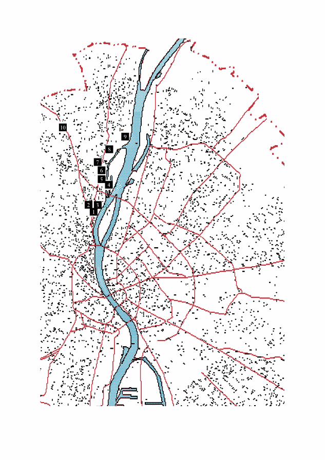
2 31
45
67
8
9
10
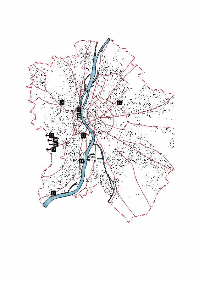
11
12
14
15
13
16
17
18
192021