Embed Size (px)
Citation preview

Edward “Zak” Zakrajsek
DeTect Global Ltd.Afon House, Worthing Road
Horsham, West Sussex
RH12 1TL
UK
www.detect-inc.com
Avian Radar Systems for Monitoring & Mitigation of
Bird & Bat Collisions with Wind Turbines

• Integrated radar systems
company based in Panama City,
Florida, USA
• Offices in Colorado, Washington
DC, Montreal, Canada &
Horsham, England
• Specialists in ‘intelligent radar’
remote sensing systems &
technologies
• DeTect started in 2003, however,
key staff working together since
1993
• Opened UK office in 2012
DeTect Overview

Expertise in Applied Radar Ornithology
• Radar ornithologists, radar engineers,
ecologists, wildlife biologists
• Expertise in bird & bat detection &
control in complex environments:
– Initial experience was in Bird Control at
US Air Bases in UK
• Over 120 avian radars delivered to
date
– Airports, wind farms, industrial
containment ponds
Avian Radar System for Golden eagle mortality risk mitigation, Wyoming USA
MERLIN Aircraft Birdstrike Avoidance Radar , USAF Bagram Airbase , Afghanistan
MERLIN detect & deter Bird Control Radar System, Ft. McMurray, Alberta, Canada
REPRESENTATIVE PROJECTS

Avian Radar Systems for Monitoring & Mitigation of
Bird & Bat Collisions with Wind Turbines
REPRESENTATIVE PROJECTS
MERLIN Avian Radar System for preconstruction avian survey, New Zealand
MERLIN Avian Radar System for proposed offshore wind farm, Massachusetts, USA
MERLIN Avian Radar System for Sea eagle mortality risk, Smola Wind Farm, Norway
• Avian Radar Systems
• Bird Control Radar Systems
• Aircraft Birdstrike Avoidance Radars
• Airspace Surveillance Radars
• Visual Warning Systems (VWS)
• Gap filler radars
• Wind profiler radars
• Hydrometeorological radars
• Stabilized shipboard radars
• Weather data systems

Radar is a simple concept
– Send out a pulse of energy and measure the time it
takes to reflect from a target and return to the
antenna
– The distance (range) to the target is one-half the
time (signal travels out and back)
– Radio waves travel at the speed of light, so accurate
distance measurement requires high-performance
electronics.
– Antenna rotates so “scans” 360 degrees and
repeats
– The position of the antenna gives the bearing
Radio Detection and Ranging

Methodologies:1. Visual assessment -
– Skilled radar ornithologist monitors radar screen, interprets data & ‘counts’ targets
– Limitations include operator variability, fatigue, target loss in ground clutter & inability to physically count all birds in “target rich” environment
2. Recorded visual assessment -
– Radar screen recorded & played back for visual assessment
– Allows more accurate counts & improved QA/QC; still unable to resolve bird target in clutter, and labor intensive
3. Automated computer assessment -
– Radar signal electronically processed with specialized software developed for bird detection
Radar Data Collection & Analysis

Horizontal
surveillance
mode (x-y)
Dual Radar Scan Configuration
Vertical scan
mode (y-z)
For traditional avian radar surveys, a
conventional marine radar is used to
collect data for ~15 minutes in each
position, then ‘flipped’ to other
position - results in ‘data gaps’

Dual Radar Scan Configuration
Dual radars scan simultaneously & continuously
MERLIN Avian Radar System
DeepWater Wind, Plum Island
Offshore Wind Farm, New
York, USA

• Technology originally developed for US Air Force
for bird-aircraft strike (birdstrikes) prevention
• MERLIN developed to provide real time, tactical
bird detection, tracking & risk assessment
– Essentially an ‘Air Traffic Control Radar’ for Birds
– Dual radar configuration provides both horizontal &
vertical detection & real-time bird numeration
– Uses proprietary MERLIN radar data processing &
operating software with automatic birdstrike warning
– Radar hardware & software developed specifically to
detect and track the unique characteristics of birds
MERLIN – Development & Evolution
USAF Bagram Airbase (2010)
Riga International Airport, Latvia (2011)

How MERLIN Works …
• Virtually any radar can detect birds
• Bird targets in conventional radar are occluded by
ground clutter, weather & other interference
• Requires highly trained, full-time radar ornithologist to
monitor radar & provide warning of hazardous bird
activity
• Labor intensive & expensive
• Physically impossible to interpret, track
& react to all birds in a “target rich”environment
• All birds cannot be "seen” due to ground
clutter
• Not operationally usable

• Radar software developed specifically for detecting
& tracking unique characteristics of bird targets
• Small irregularly moving, variable Radar Cross
Section (RCS) target
• Not modified aircraft or marine radar software
• Digitizes & processes radar signal in real-time with
live remote display of information
• Unique clutter suppression & Doppler processing
improves bird detection in high clutter & near ground
• User friendly output options include aviation type
symbols (target trail, data tags for speed, size,
bearing, heading)
• Modular, easily customizable, GUI design
• Automatic routines for real-time risk assessment,
alerting & auto-response actions (e.g. warning
alarms, deterrent activation)
MERLIN Operating System

MERLIN Operating Software

MERLIN SQL Data System
All target data continuously written to the MERLIN SQL
Server data system:
• Real-time processing for web-based displays & risk
analysis
• Historical data by user selectable data periods (daily,
monthly, annually, etc.)
• Documents environmental compliance
Standard & custom report formats supported
• Tabular & graphic presentations
• Includes auto-report engine that generates daily reports
at end of each defined period (e.g. 24 hours)

Provides relatively complete picture of activity over
time & space
Large survey area
24/7/365 data collection - at night
Provides large, high-resolution datasets – X, Y, Z, & T
Provides precise target count, direction, speed, and
flight altitude
Size categories – not species
Enables real-time assessment & mitigation
Technology advancing – performance improving
MERLIN Avian Radar System
Bache Wind Farm, Turkey
Why Use MERLIN for Wind Farms?

1. Pre-construction monitoring
– Assess bird activity throughout the Wind Resource Area
– Assess project mortality risks
– Linked to post-construction data
– Year-round, 24-7 survey of bird activity at the site
2. Post-construction monitoring
– Monitor bird activity WITH wind turbines present
– Monitor changes in target numbers or behavior
3. Operating wind farm mortality risk mitigation
– Radar-activated turbine curtailment or deterrent activation
– Custom risk control parameters based on pre- or post-
construction data
– Supports mitigation of risk to resident or migratory birds
MERLIN – for Wind Energy Projects

MERLIN Avian Radar System
C-Power Offshore Wind Farm, Belgium

Colors represent the flight direction
MERLIN Radar Data

MERLIN Radar Data
Frequency Distribution over 24-hr day

0
200
400
600
800
1000
1200
1400
1-Apr
2-Apr
3-Apr
4-Apr
5-Apr
6-Apr
7-Apr
8-Apr
9-Apr
10-Apr
11-Apr
12-Apr
13-Apr
14-Apr
15-Apr
16-Apr
17-Apr
18-Apr
19-Apr
20-Apr
21-Apr
22-Apr
23-Apr
24-Apr
25-Apr
26-Apr
27-Apr
28-Apr
29-Apr
30-Apr
1-May
2-May
3-May
4-May
5-May
6-May
7-May
8-May
9-May
10-May
11-May
12-May
13-May
14-May
15-May
Nig
htl
y ta
rget
pas
sag
e ra
te (
targ
ets/
km/h
r)
0%
5%
10%
15%
20%
25%
30%
35%
40%
Per
cen
t ta
rget
s w
ith
in R
SZ
Nightly TPR
% targets within RSZ
MERLIN Radar Data
0 10000 20000 30000 40000 50000
0
50
100
150
200
250
300
350
400
450
500
550
600
650
700
750
800
850
900
950
1000
1050
1100
1150
1200
1250
1300
1350
1400
Ta
rge
t h
eig
ht
(to
p o
f 5
0-m
ete
r in
cre
me
nt)
Number of Targets
0
100
200
300
400
500
600
700
0 1 2 3 4 5 6 7 8 9 10 11 12 13 14 15 16 17 18 19 20 21 22 23
Hour
Avera
ge T
arg
et
Heig
ht
(m)
Flight altitude
DistributionMean Flight Altitude by Hour

Risk Assessment
Site-level Risk Assessment:
• Performed in real time for an entire wind farm
• Currently the model for migratory songbirds
• Assess risk for the location, use information on environmental conditions and frontal movements of birds
• Provide a risk model for curtailment decisions with thresholds
Single Turbine Risk Assessment
• Performed in real time at single or clusters of turbines
• Currently targeted at large raptors
• How close is too close?
• Provide a scale for curtailment decisions

• Simple Mission Statement:
To find when and where birds are active at rotor swept heights and the
conditions under which they may collide with the wind turbines
• Migration may be a “when”
• Daily foraging flights may be a “when”
• Seasonal movements or weather avoidance (from hurricanes or flooding for example)
may also be a “when”
Risk Assessment

• Avian radar integrated with the wind farm SCADA system (Supervisory Control And Data Acquisition)
• MERLIN applies custom ‘rule sets’ gathered from radar and other sensors as needed
• May include passage rate, size, position, direction of flight, altitude, weather, etc. to estimate collision risk
• Radar initiated mortality risk mitigation response options:
• Alert to wind farm operators/control centers
• Automated idling of turbines with automatic or manual turbine restart when risk abates
• Activation of bird deterrent devices
• Adaptive Management - rule sets can be modified
MERLIN SCADA: Radar-based Risk Mitigation

Implementation process:
1. Pre-construction surveys used to define high-risk strike conditions & mitigation parameters required for each site.
2. Radar system programmed with rule set based on these conditions
3. Radar system detects & tracks birds in real time, & gathers weather or other data
4. When rule set is met, the radar system initiates pre-determined mitigation measures
5. Post-implementation data used to refine rule sets
Qualifiers & Notes:
• Level of study and implementation is unique by site
• Appropriate, long-term pre-construction studies are the best approach
• Refine with post-construction operational studies (Adaptive Management principles)
• Mitigation technique minimizes both bird mortality & turbine downtime by targeting high risk periods in real time
MERLIN SCADA Implementation

Conditions and Risk
• For migrating birds, a condition WHEN birds May collide with a turbine is during low visibility conditions
• For raptors, conditions WHEN birds May collide with a turbine are the absence of strong thermals or presence of prey or territorial behavior or presence of orographic lift
• For bats the list is longer but does not include low visibility yet
• Bird risk is based upon the best risk assessment and collisions with other structures, bat risk is based on actual mortality at multiple sites
• Risk Assessment and Risk Management are evolving areas of wind-wildlife management

MERLIN Avian Radar System
Penascal Wind Farm, Texas, USA

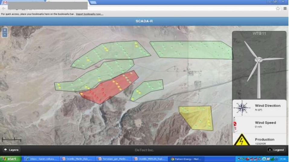
MERLIN SCADA – Displays
• Real-time remote display of data from the MERLIN system
– User-specific levels of detail
– Activity reports (passage rates, curtailment events, track & altitude data)
– Automatic ‘high activity’ alerts
– Allows remote user query for periodic & trend analysis
– Allows operations center to forecast curtailments & restarts
Operations Center Display
Zorlu Energy
Bahce Wind Farm
Turkey

MERLIN Avian Radar System
El Pino Wind Farm, Spain

Mitigating Mortality Risk of Large Soaring Birds
MERLIN SCADA Raptor Roadmap
Step 1: Gather Information
Step 2: Identify Risks and Develop a Predictive Model
Step 3: Use Ornithologists as Preliminary Decision Makers
Step 4: Work towards Automating Decision Steps
Step 5: Refine Mitigation Strategy with Adaptive Management

Mitigating Mortality Risk for Large Soaring Birds
The MERLIN SCADA-Raptor application uses radar-assigned risk indices for individual raptor-type targets relative to their distance and heading from each wind turbine as measured by the radar
Challenges:
• Accurately identifying when large soaring bird-type birds are at risk
• Developing economically viable radar configurations & supplementary sensors
• Minimizing wind turbine downtime to allow for profitable energy production
• Finding a solution that is applicable to the variety of potential collision causes
• Validating operational efficacy

MERLIN SCADA – Raptor
• The risk components from both the vertical & horizontal radars used
– A “3D” risk assessment is developed
– Risk value generated based on distance & direction from turbine
• Operational system:
– Radar activated idling of individual turbines based on risk for each target when the risk threshold is exceeded
– On-line operator web interface shows color-coded risk status of each turbine in real-time
– Automatic idling or operator initiated through web interface

Ground Truthing
Incorporation of ornithologist
• Visually verified tracks required for moving forward towards taxonomic classification or identification
• Use radar SCADA interface to curtail turbines
Using capabilities within MERLIN
• Limitations when comparing two independent datasets
• Ability to tag tracks with MERLIN software
• Improve behavioral observations, correct for visual bias in location and altitude
Can be augmented with other technology
• Camera systems
• GPS and VHF tagging

Questions?
Headquarters
DeTect, Inc.1022 West 23rd Ave, # 620
Panama City, Florida
32405
USA
+1.850.763.7200
Europe
DeTect Global Ltd.Afon House Worthing Road
Horsham, West Sussex
RH12 1TL UK
+44.01403.788315
www.detect-inc.com
International
DeTect International5801 Lee Highway
Arlington, Virginia
22207
USA
+1.703.533.8555 ext 588