Embed Size (px)
Citation preview
Öxl
Hraunhöfn
(Selvellir)
(Hraunlönd)
"
"
"
"
"
""
Kálfá
Hraunhafnardalur
Stemmuklettur
Kinnarhyrna
Tunguhyrna
Egilsskarð
Frambúðir
Miðtangi
Stangir
Búðaklettur
Rávík
Búðahraun
Búðavík
Axlar-hyrna
B r e i ð a v í k Búðir
Fagurhóll
Búðahellir
Klettsborgir
Selavík
Sleggjuvík
VikBót
Syðsti melurJárnbarði
Keflavík
Iglutjörn
Klettsgata
Jaðargata(Jaðragata)Húsanesvatn
(Miðhúsavatn)
Knörr
Miðhús
Ytri Knarratunga
Syðri Knarrartunga
(Ósakot)
(Kinn)
Búðaós
LangavatnBreiðavatn
!
!
!!
!
!
!!
³³574
æ
¬34
¬33
¬35
18 88
15
(Laugarbrekka)
(Dagverðará)
(Miðvellir)
Stapagjár
"
""
"p
"
""
Dagverðará
Sleggjubeina
Kálfatraðarhraun
Hellnahraun
Sölv
aham
ar
Látrasnoppa
Hellnanes
KlifhraunHeljarkinn
Sönghellir
Bólhólar
Lend
inga
lága
r Básavík
Hval
vík
Hellnavík
Gatklettur
Baðstofa
Stapafell
Bárðarlaug
x
Arnarstapi
Hellnar
Smálækja
rhlíð
Merarvík
Botn
shlíð
Gróuhóll
Hjartarbrekkur
Kringlumýrargata
Kj óadal
agata
Kýrskarð
Laugarvatn
!
!
!
!
!
!
!
!
!
!
!
!
!
!
!
!
Kvíahnúkur
³³574
ë
ë
æ
Leó
Brighton
¬30
¬31
¬32
99
21
41
526
118
432
(Foss)
Hella
Gufuskálar
Innri-Bugur
(Laugarbrekka)
(Malarrif)
(Dagverðará)
(Sveinsstaðakot)
(Skarð)
(Hella)
(Háarif)
(Garðar)
(Saxhóll)
(Nýjabúð)
(Bakkabúð)
(Fróðárkot)
(Hólahólar)
(Einarslón)
(Miðvellir)
(Hraunskarð)
(Þæfusteinn)
Stapagjár
(Vaðstakksheiði)
"
"
"
""
p"
"
"
"
"
""
"
"
"
"
p
"
"
"
"
Höskuldsá
Hva
lsá
Barnaá
Dagverðará
Laxá
Þverlækur
Ljósulækir
Fossá
Hól
mke
lsá
S leggjubeina
Rif
Ólafsvík
Hellissandur
Væjuhraun
Kálfatraðarhraun
Öndverðarneshólar
S
v ö r t
u l
o f t
Mannfallsbrekkur
Lónbjarg
Djúpalónssandur
Drangahraun
BekkjahraunSandahraun
Svartahraun
P r e s t a h r a u n
Háa-hraun
Hnausahraun
Harðikambur
Vatnsborgarhóll
Saxhólsdalur
Hellnahraun
Gáluvíkurtangi
Stakkabrekkur
Sölv
aham
ar
Öndverðarnes
Eysteinsdalur
Hyrningsdalur
Bárðarhaugur
Skálasnagi Hellisfjall
Valhraun
Brimnes
Sandfell
Giljatungur
Látrasnoppa
Burstahraun
Öldungahóll
Lóndrangar
Hólahólar
Ljósaskriða
Bárðarkista
Hellnanes
Kothraun
Járnbarði
Klifhraun
Sjónarhóll
Heljarkinn
Rauðhóll
J ö k
u l þ ú f u
r
Sönghellir
Þúfubjarg
Purkhólar
Krákhólar
Hvalhöfði
Svalþúfa
Grashóll
Bólhólar
Blákolla
Miðfell
Sandfell
Melnes
Lend
inga
lága
r Básavík
Gjaf
i
Hval
vík
Hellnavík
Hranavör
Lönguvík
Þrælavík
Gatklettur
Fálki
Baðstofa
Krossavík
Skarðsvík
Beruvík
Dritvík
Kambsheiði
N e s h r a u n
Bervíkurhraun
Gamlavík
Hrói
Hólamóður
Stapafell
Eyrar
Fiskbyrgi
Gufuskálavör
Írskrabrunnur
Þórðarklettur
Sauðhóll
Hólavogur
Bárðarlaug
Skaflakinn
Hólatindar
Ingjaldshóll
Bæ
jarhraun
HákonarhóllHríshóll
Móðulæ
kur
Anne Dorothea 1817
Mildred P.F.Z.P 1947
Malarrif
x
JökulhálsArnarstapi
Hellnar(Lónskirkja)
Klofningur
Rauðkúla Rauðhryggur
Hamraendafjall
Blágil
Klukkufoss
Harðibali
Geldingafell
Skei
ðsan
dur
Heiðar
Torfmúlahraun
Vatnshellir
MiðþúfaNáttmálahnúkur
Brennivínskúlur(Brenningskúla)
Rauðfeldargjá
Berutóftir
Skorri
Selvarða
Heimahraun
Hólsdalur
Hól
astíg
ur
Þverdalir
Vatnsgeirar
Smálækja
rhlíð
Rjúkandi
Merarvík
Botn
shlíð
Gróuhóll
Hjartarbrekkur
Helguhóll
Hvalrauf
Hallberukjálki
Vætti
r
Írskubúðir
Sandhólar
M a l i r
Saxhólsbjarg
(Forni - Saxhóll)
L an g
atrö
ð
Snekkjufoss
Lónland
Purkhólahraun Kringlumýrargata
Kjó
adal
agata
Kýrskarð
Móðurvör
(Ytri-Bugur)
(Stapatún)
(Litlalón)
(Litlahella)
(Helludalur)
(Sveinsstaðir)
Snæfellsjökull
Lambhagatjarnir
Dýjadalsvatn
Laugarvatn
Beruvíkurlækur
!
!
!
!
!
!
!
!
!
!
!
!
!
!
!
!
!
!
!
!
!
!
!
!
!
!
!
!
!
!
!
!
!
!
!
!
!
!
!
!
!
!
!
!
!
!
!
!
!
!
!
!
!
!
!
!
!
!
!
!
!
!
!
!
!
!
!
!
!
!
!
!
!
!
!
!
!
!
!
!
!
!
!
!
!
!
!
!
!
!
!
!
!
!
!
!
!
!
!
!
!
!
!
!
!
!
!
!
Þríhyrningur
Skál
Enni
Búrfell
Saxhólar
Tindfell
Hreggnasi
Sandkúlur
Kvíahnúkur
Botnsfjall
Geldingafell
Grafarhnúkur
Rjúpnaborgir
Svörtutindar
³³570
³³579
³³572
³³574
³³574
ë
ë
ë
ë
ë
ë
ë
ë
ë
ëë
ëë
æ
ò
æ
Leó
Brighton
Bára1964
Böðvar1961
Sölöven1857
B.V Ása1925
Barðinn1987
Svanborg2001
Svanurinn1932
Epine G. Y. 71948
Brilliant Star1882
¬4
¬5
¬24
¬15
¬2
¬6
¬8
¬19
¬21
¬7
¬23
¬20
¬10
¬9
¬1
¬17¬18
¬14
¬3
¬13
¬12¬11
¬16
¬22
¬25
¬32
¬30
¬31
¬26
¬27
¬28
¬29
65
25
36
99
37
21
67
38
41
13
38
68
29
37
57
706
552
232
125 469
384
279
673
844
460
526
290
768633
824
488
613
501
118
432
510
418
592
611
556
168
683
605
165
113
1047
1446
0 1 2 3 4km
© Landmælingar Íslands 0 0,5 1 1,5 2km
0 0,5 1 1,5 2km
Kortagerð Jón Örvar G. Jónsson
Suðurlandsbraut 24 – 108 ReykjavíkTel. 591 2000 – Fax 591 2020
www.umhverfisstofnun.isText: Snæfellsjökull National Park. Photos: Snævarr Guðmundsson,
Hákon Ásgeirsson, Jóhann Óli Hilmarsson, Ásta Davíðsdóttir, Linda Björk Hallgrímsdóttir and Þórunn Sigþórsdóttir. Maps: Jón Örvar Geirsson Jónsson.
Maps based on data from The National Land Survey of Iceland.Layout: Völundur Jónsson. Printing: Guðjón Ó - vistvæn prentsmidja Issue No.: UST-2009-08
Trails in Snæfellsjökull National Park
Where shall we go?There are many hiking trails in and around Snæfellsjökull National Park, and you are sure to find something suitable. Some are clearly marked, and most routes are easy to follow. You can make your own route by joining a series of trails. Please remember that there are few sources of drinking water in the National Park, so you should take an adequate supply of water when you set off. Hikers who intend to spend several days following longer routes are requested to inform National Park staff of their route and schedule before starting their trip.
EquipmentMake sure you are appropriately prepared for the length of the trail you will follow. The following basic equipment is recommended for day trips:
» Sturdy shoes
» Water bottle filled withwater
» Light waterproofclothing
» Hiking poles
» Binoculars
» Camera
» Spare pare of socks
» Sunglasses
» Plasters
» Compass/GPS unit
» Maps
1. Írskrabrunnur –Gufuskálavör – Fiskbyrgi
circular routE
2 km / 1 hour in total
Old well, farm ruins and fish storage huts beside the lava field. This trail starts from the car park at Írskrabrunnur. After visiting the well, head in the direction of Gufuskálavör. This is an easy 10-minute walk past an old rural rubbish tip. Boats rowed out from this coast in past centuries and their keels left grooves on the rocky shore. Continue past the remains of the farm at Gufuskálar to the fish storage huts on the edge of the lava field. Take care when crossing the main road. The walk from Gufuskálavör to the huts takes about 25 minutes. The final section passes through the lava. Return to Írskabrunnur.
Take care – there are many natural dangers. Be especially alert in these areas:
– Snæfellsjökull Glacier– lava fields– cliffs– the seashore
!
The National Park's phone numbers are 436 6888 and 436 6860.
Fax 436 6861 E-mail [email protected] and
visit our website at www.umhverfisstofnun.is.
Birdwatching hide
Hiking trail no.[?
Hiking trail with posts
Hiking trail, unmarkedTown/village
Main road
Other road
Track
Nature Reserves
Natural monuments
National Parks
Stranding site
Map keyVisitor centre
Lighthouse
æ Church
Information
Car park
Campsite
Golf course
Protected monuments
ë
DIFFICULTY LeveL
21. hólavogur – Dritvík– Djúpalónssandur
trail With posts
4.5 km / 2.5 hrs.
A pleasant footpath along the coast at Dritvík. The coves and inlets along this attractive stretch of coast are lined with cliffs. The path through the lava is generally distinct – it is an old route that has now been marked with posts.
22. Djúpalónssandur– Dritvík
trail With posts
1 km / 20 mins. Each Way
Dritvík is only accessible on foot. This is a popular path between Djúpalónssandur and Dritvík, but proceed with caution as there may be heavy surf on the beach with a strong
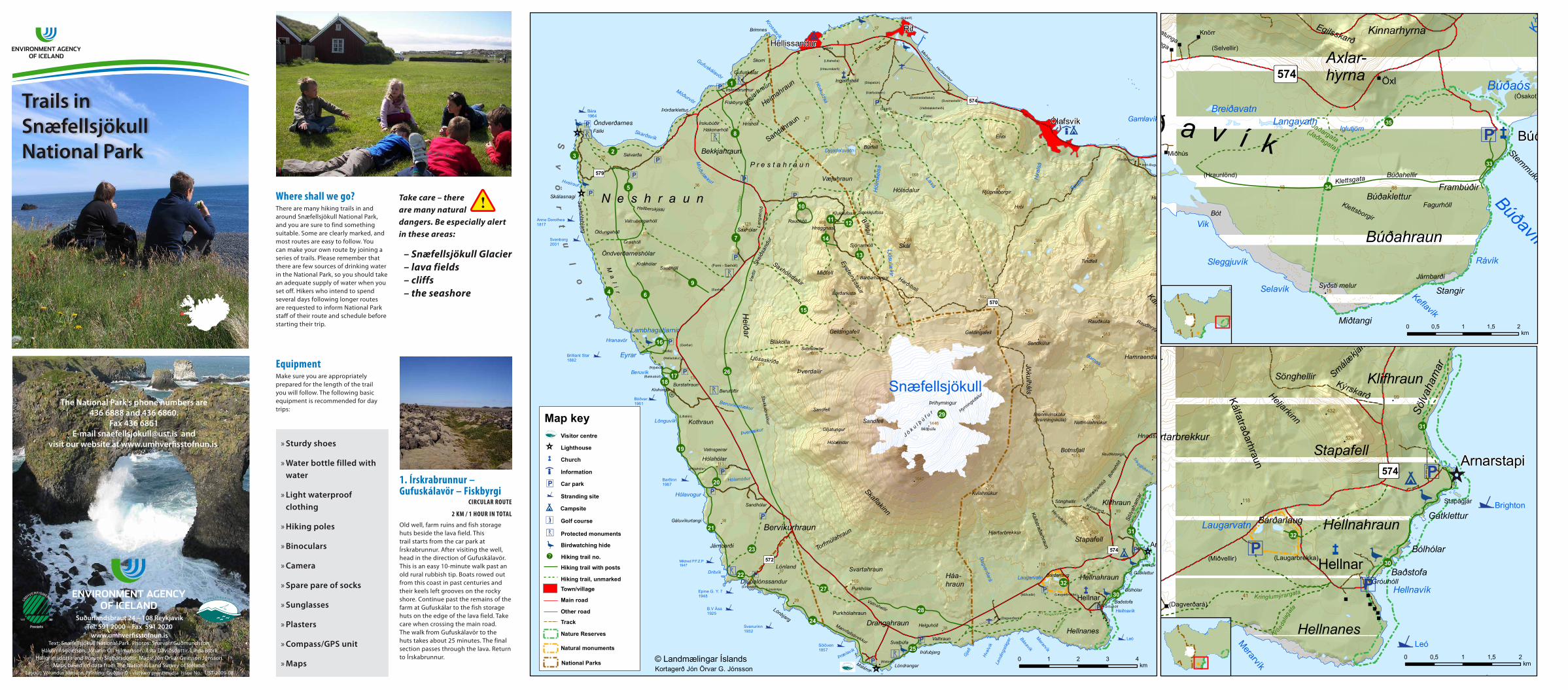
33. Búðir church –Frambúðir
trail With posts 500 m Each Way, 30 mins in total
A delightful path to Frambúðir where the spirit of the past lives on in the ancient relics. The trail starts from Búðir Church. Instead of retracing your steps, return to the church along a path marked with posts along the coast.
34. Búðir – Búðaklettur– miðhús
to BúðaklEttur anD Back to Búðir, 4 km in total, 2–3 hrs.
From Búðir to miðhús, 6 km / 2–3 hrs.
The route to Búðaklettur and Búðahellir follows Klettsgata. The trail around Búðaklettur and on up to the crater is marked with posts. This is a very fragile area – please keep to the trail. The route continues optionally along Klettsgata to Miðhús, an additional 2 km.
Information on the Walk Route Table Short walks, 2 hours or less
Longer walks, 2 hours or more
route name of path Distance timeDifficulty
levelround path posts cairns
1 Írskrabrunnur - Gufuskálavör - Fiskbyrgi 2 km 1 h Yes x
2 Móðuvör - Skarðsvík - Öndverðarnes 4 km 2-3 h No x
3 Öndverðarnes - Skálasnagi 2 km 1 h No
4 Skálasnagi - Beruvík 6 km 3 h No
5 Öndverðarneshólar 6 km 3 h Yes x x
5 Vatnsborg 2 km 40 min No x
6 Öndverðarnes um Neshraun 6 km 3 h No x
7 Hólastígur: Móðulækur - Saxhóll 2 km 1 h No x
8 Hólastígur: Móðulækur -Gufuskálar 3 km 1,5-2 h No x
9 Sauðhóll 2 km 1 h No x
10 Rauðhóll 2,3 km 1 h Yes x
11 Klukkufoss 600 m 20 min No x
12 Snekkjufoss 500 m 20 min No x
13 Sjónarhóll 300 m 10 min No x
14 Hreggnasi 1 km 40 min No x
15 Saxhóll - Bárðarkista 5 km 3-4 h No
16 Eyrahringur 3 km 2 h Yes x
17 Beruvíkurbæir 1,5 km 1 h Yes x
18 Stutthalastígur 600 m 20 min No x
let us make a habit of preserving nature» Respect the land and keep it tidy.» Keep to the marked trails – leave the ground as you
found it.» Roads are for driving on – please do not leave them.» Leave plants and animals in peace – this is their home.» Observe the park’s regulations and obey rangers’
instructions.» Enjoy the natural peace and tranquillity.» Be at one with your surroundings.
2. móðuvör – skarðsvík– Öndverðarnes
trail With cairns
4 km / 2–3 hrs.
An old track between Gufuskálar and Öndverðarnes. The route passes a charming, sheltered cove with golden sand. A number of fishing and farming relics can be seen at Öndverðarnes. An old well, known as Fálki is an ancient water source. Many bird species nest in the area. Gannets dive for food and whales can sometimes be seen from the shore.
3. Öndverðarnes – skálasnagi
2 km / 1 hrs.
A trail through a black lava field. An old fox trap built with lava stands near the trail. Birds have colonised the cliffs known as Svörtuloft.
6. Beruvík – Öndverðarnesvia neshraun
trail With cairns
6–8 km / 3 hrs.
Start from the car park near Lambhagatjarnir. Follow the old track known as Nesgata to Öndverðarnes. Cairns mark the way. Cuttings and paving are evident in the southerly section between Moldflögur and Grashólshellir. The track continues for 6 km to the Öndverðarnes road – an additional 2 km section leads to the tip of the peninsula. The craters and plant life are sensitive to disturbance – please keep to the signposted footpaths.
hólastígurtrack markED With posts
An old track between Gufuskálar and Saxhóll. This route is best followed in two stages. There is a car park half way where the trail meets the Móðulækur stream (signposted Hólastígur).
4. skálasnagi – Beruvík6 km / 3 hrs.
A lighthouse stands near the start, and further south there are relics from the time when men collected eggs and birds from the cliff face. This is a difficult route over rough lava. Charming tarns lie in Beruvík where there is a deserted settlement.
5. Öndverðarneshólar– Vatnsborg –Grashólshellir
circular routE
6 km / 3 hrs. in total
Start from the signposted car park at Öndverðarnes. A marked path leads past the lava to Vatnsborg. Caves and lush pockets of plant life abound in the lava. Vatnsborg is a bracken-filled crater encircled by crags. The trail leads on to Grashóll then along Nesgata, an old cairned track, returning to the start along the road. The craters and plant life are sensitive to disturbance – please keep to the signposted footpaths.
hólastÍGur
7. móðulækur – saxhóll2 km / 1 hrs.
Cross the bridge over the Móðulækur stream. An easy walk through the lava leads to the Saxhóll crater, which erupted 3–4000 years ago. Keep to the path when climbing to the lip of the crater to avoid damaging this sensitive environment. Steep sections with loose lava. Magnificent views at the destination. Return by the same route.
hólastÍGur
8. móðulækur – Gufuskálar3 km / 1.5–2 hrs.
From the car park by the Móðulækur stream, pass the mast crossing a flat area where there are interesting formations caused by frost. Descend to the fish storage huts above Gufuskálar.
9. sauðhóll2 km / 1 hrs.
You can see an old shelter for sheep on Sauðhóll.
10. rauðhólltrail With posts – circular routE
2.3 km / 1 hrs.
A trail marked with posts leads from the Eysteinsdalur road to Rauðhóll, the source of the Presthraun lava field which flowed into the sea between Hellissandur and Skarðsvík. The track to Rauðhóll is 1 km each way. An interesting alternative follows the Móðulækur stream where there are potholes. Lava channels lead from Rauðhóll down to charming, reedy tarns. The recommended route goes down the lava channels and returns to by the stream.
11. klukkufoss waterfall trail With posts
600 m / 20 mins.
Start from the Eysteinsdalur road. Short walk to the basalt outcrop and Klukkufoss waterfall where there are impressive columnar basalt formations.
12. snekkjufoss waterfalltrail With posts
500 m / 20 mins. Each Way
Start from the Eysteinsdalur road. The trail to Snekkjufoss waterfall is marked with posts. A short walk from the road.
13. sjónarhólltrail With posts
300 m /10 mins.
A track from the Eysteinsdalur road marked with posts leading up to an old crater. Magnificent views.
14. hreggnasitrail With posts
1 km / 40 mins. Each Way
The path to Hreggnasi starts from the footbridge over the stream at the entrance to Eysteinsdalur. Trail marked with posts onto Hreggnasi (469 m). Fairly steep but generally easy route. There are steep cliffs on the other side of the summit.
towards the shore, mostly on flat, ropy lava. Beautiful tarns lie close to the remarkable shore in spectacular surroundings.
17. Beruvíkurbæirtrail With posts – circular routE
1.5 km / 1 hrs.
Start from the car park at Beruvík. Pass the farm ruins and skirt the ponds. An easy, well-marked stroll over flat areas of grassland and lava with delicate moss-covered stretches.
18. stutthalastígurtrail With posts
600 m / 20 mins.
A path between Klofningsrétt and Beruvík. Interesting track through attractive lava.
15. saxhóll – Bárðarkista5 km Each Way, 3–4 hrs.
The best way onto Bárðarkista is from the Vættir rocks by the stream opposite the start of the track to Saxhóll. Start from the Útnesvegur car park. Walk over the moorland beside the stream Saxhólslækur then go further south to avoid the gill south of Bárðarkista. Turn north up onto the summit. It is generally easy to reach the top from this approach. Bárðarkista is partly surrounded by steep crags – not for those who have a fear of heights.
16. Eyrar circletrack markED With posts
– circular routE
3 km / 2 hrs.
Two interesting tracks lead from the car park near Lambhagatjarnir. One is described in route 6, while the other is a circular route around Eyrar. This is an easy, posted trail, leading down
undertow. Leave the car park and descend the Nautastígur path to the boulders where fishermen used to test and demonstrate their strength. From there, go along the beach to Sessar whence a marked path heads to Dritvík. Dritvík was once home for up to 600 seasonal workers. An optional diversion leads to Suðurbarðinn where there is a labyrinth. Return by the same route.
23. Dritvík – sandhólar 3 km / 1.5 hrs.
Follow the old fishermen’s route past Beruvíkurhraun lava field to Sandhólar. This walk takes 1½ hours from Dritvík. The total length from Djúpalónssandur to Sandhólar is 4 km. Many people say the walk is more attractive in the opposite direction.
24. Djúpalónssandur –Einarslón – malarrif
trail With posts
6 km / 2–3 hrs. Each Way
Coastal trail passing Einarslón. There are many ruins in the area around Einarslón. The colourful cliffs are eye-catching with exposed strata. A lighthouse (1946) stands at Malarrif, which was a working farm until 1997. The trail crosses grassland, some rather coarse.
25. svalþúfa – lóndrangar (thEn on to malarriF) trail With posts
sValþúFa. – lónDr. 1 km / 30 mins.
sValþúFa – malarriF 1.6 km / 1 hr.
A 1 km trail from the car park to Lóndrangar and back. Walk up onto Svalþúfa, a location rich in folklore, where there is teeming bird life that is best observed using binoculars. The path to Lóndrangar descends the slope then follows the shoreline. The final section passes sensitive moss-covered areas – please keep to the path. A number of structures date back to the period when boats rowed out from Drangavogur. Return along the marked path a little further inland, or continue along the coast to Malarrif, ½ km further on.
19. klofningsrétt– hólahólar
trail With posts
4 km / 2 hrs.
A path following the Beruvík shoreline. Beruvík was inhabited until the middle of the 20th century and Hólahólar was a busy farm. Walk on grassland along the changing coastline. A stream must be crossed on the way. Pass Litlalón, the ruins of a smallholding.
20. hólahólar circletrail With posts – circular routE
2.5 km / 1 hrs.
Start from Hólavogur and head towards Hrafnabjörg. The walk is over grassland with sheep tracks, past ponds and ruins to the site of the old farm at Hólahólar. Turn towards the sea and return along the shore crossing fields of boulders. An optional diversion leads to Dimmugjóta.
26-28. Efstivegurpartly markED With posts
In olden days, many busy tracks lay at the foot of the glacier. One of them was Efstivegur. An 11 km marked section of this old route lies between (26) Beruvíkurhraun og Skeiðsandur. Shorter, easily followed sections run from (28) Háahraun to Purkhólar (4 km), and from (27) Purkhólar to Lónland in Beruvíkurhraun (4.5 km).
29. snæfellsjökull Glacier3–5 hrs.
Hiking up Snæfellsjökull takes about 3-5 hours. It is not recommended for inexperienced hikers to attempt hiking up this glacier. People who intend to take on Snæfellsjökull are strongly encouraged to obtain information regarding trails and hiking conditions before setting off, and to proceed with extreme caution. In the course of summer large crevasses are formedin the glacier, which render it unsuitable for hikers.
30. arnarstapi – hellnartrail With posts
2.5 km / 45–60 mins.
The area between Arnarstapi and Hellnar, from the sea up to the glacier, is a large lava field known as Hellnahraun. The track Neðstagata crosses the lava following the coast. Evidence of powerful natural forces is clear to see in the shape of the landscape, scoured rock faces and canyons. Kittiwakes sit on nests in the gills around Arnarstapi. The coast is a protected area with unique cliff formations.
31. sölvahamar1.5 km / 50 mins.
The walk to Sölvahamar from Arnarstapi takes under one hour and is well worthwhile.
32. Bárðarlaugtrail With posts
300 m / 10 mins.
A crater above Hellnar that has been ground down by the glacier. Bárðarlaug became a protected area in 1980. The trail starts from the car park. Ascend the steep slope to the rim of the crater.
klettsgataAn old track through Búðahraun lava field. Klettsgata leads from Búðir church to Búðaklettur via Búðahellir and on through the lava. Over the centuries, horses hooves have worn a groove in the smooth lava. Dense bracken gives the lava an exceptional appearance. Klettsgata is a distinct and entertaining trail suitable for everyone.
35. Búðir – miðhúsvia Jaðargata
6 km / 2–3 hrs.
Jaðargata is an old track that follows the edge of the lava field to the large outcrop south of Miðhúsatún where it joins Klettsgata. It is now frequently indistinct. Allow two hours to walk from Búðir. The walk from Axlarhólar to Miðhús takes one hour.
easY - Generally smooth paths, without any obstacles to speak of.
DemanDIng - Longer or shorter rough and difficult stretches such as unbridged streams, loose gravel, uneven terrain, etc.
DIFFICULT - Obstacles and difficulties such as unbridged rivers and steep terrain. Can be dangerous in poor conditions for the inexperienced.
route name of path Distance timeDifficulty
levelround path posts cairns
19 Klofningsrétt - Hólahólar 4 km 2 h No x
20 Hólahólahringur 2,5 km 1 h Yes x
21 Hólavogur - Djúpalónssandur 4,5 km 2,5 h No x
22 Djúpalónssandur - Dritvík 1 km 20 min No x
23 Dritvík - Sandhólar 3 km 1,5 h No
24 Djúpalónssandur - Malarrif 6 km 2-3 h No x
25 Svalþúfa - Malarrif 1,6 km 1 h No x
25 Svalþúfa - Lóndrangar 1 km 30 min No x
26 -28 eFsTIvegUR
26 Skeiðsandur - Beruvíkurhraun 11 km No x
27 Beruvíkurhraun - Purkhólar 4,5 km 2-3 h No
28 Purkhólar - Háahraun 4 km 1-2 h No x
29 Snæfellsjökull 3-5 h No
30 Arnarstapi - Hellnar 2,5 km 1 h No x
31 Sölvahamar 1,5 km 50 min No
32 Bárðarlaug 300 m 10 min No x
33 Búðir - Frambúðir 500 m 15 min No x
34 Búðir - Miðhús (Klettsgata) 6 km 2-3 h No x
34 Búðir - Búðaklettur 2 km 1 h No x
35 Búðir - Miðhús um Jaðargötu 6 km 2-3 h No
Take only pictures and memories,leave nothing
behind!


![[Shinobi] Naruto 574](https://img.pdfslide.tips/doc/110x75/568bf4b01a28ab89339ef1fc/shinobi-naruto-574.jpg)