Embed Size (px)
Citation preview
CADASTRE SURVEY (SGHU 2313)
WEEK 1-INTRODUCTION TO CADASTRE SURVEY
SR DR. TAN LIAT CHOON07-5530844
016-4975551
1
OUTLINE• Definition of Cadastral Survey
• Cadastre and Cadastral
• Department of Survey and Mapping Malaysia (JUPEM)
• Land Surveyors Board of Peninsular Malaysia (LJT)
• Royal Institution of Surveyors Malaysia (RISM)2

DEFINITION OF CADASTRAL SURVEY
3
Definition
Cadastral surveying is the term generally used todescribe the gathering and recording of data about landparcels even though the records do not form part of anofficial cadastre.
When properties are initially registered, governmentofficials have traditionally undertaken the processes ofcadastral surveying and land title adjudication.
4
Definition
Cadastral surveying is the definition, identification,demarcation, measuring and mapping of new or changedlegal parcel boundaries. It usually includes the process ofre-establishing lost boundaries and sometimes resolvingdisputes over boundaries or other interests in real property.
5
Definition
Cadastres and cadastral surveys are aspects of land administration.
• The primary object of a cadastral is to determine for each landparcel, its location, the extent of its boundaries and surface area,and to indicate its separate identity, both graphically on a map or ina record as well as physically on the ground.
• Its secondary objective is to provide information for a multipurposecadastre to fulfil the overall information requirements of landadministration.
• Cadastral plans can fulfil many of the functions of large-scaletopographic maps, not only serving such purposes as boundarycontrol, registration of title and valuation but also forming a basis ofplanning and development.
6
Definition
The basic features that are recorded in a cadastre are the landparcels and their boundaries. Good practice will result in lawsrelating to parcels and their boundaries that:
• Provide a legal definition of a land parcel;• Recognize that boundaries may be vertical or horizontal;• Differentiate between the legal position of a boundary and
the physical position of objects;• Define the priority of evidence; and• Avoid getting into detail over the precision with which
boundaries should be surveyed for the purposes of landtitling.
7

Definition
In order to guarantee the accuracy of boundary surveysand to apply quality controls to the work of the cadastralsurvey, it is common for survey regulations and proceduresto be introduced.
These often prescribe the manner in which surveys areto be carried out as well as the standards that must beachieved.
Survey regulations and procedures may also prescribethe necessary qualification for the granting of licence toundertake cadastral surveys.
8
Definition
The objectives of cadastral surveys are to acquireinformation, process it, coordinate and finally to presentthe vital information.
Cadastral surveying is an expensive process not only inits execution but also in the loss of capital from delays indevelopment and investment which may arise owing toinefficiency.
9

Section 83 National Land Code 1965-Survey for purposes of alienation
under final title.
Where any land is surveyed in accordance with theprovisions of section 396 National Land Code 1965 for thepurpose of its alienation under final title, the boundariesdetermined on the survey shall accord as nearly as may bewith those indicated by the plan and description byreference to which the approval of the State Authority wasgiven.
10

CADASTRE AND CADASTRAL
11
Objective
To understand the role of the cadastre in the administrationof Federal or State or jurisdiction, its operation andcomponents.
12
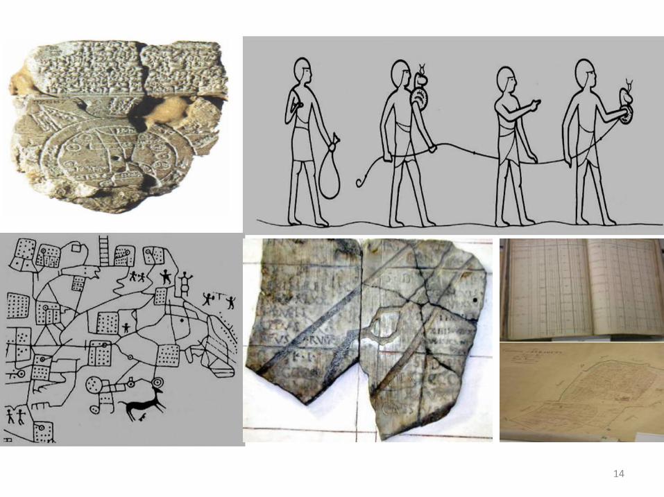
History of Cadastres
• Babylonian 4000 BC• Egyptians 3000 BC• Italy 1600 BC• Roman Empire 300 AD• Doomsday Book 1076 AD• Maria Theresia Cadastre 1792 AD• Napoleonic Cadastre 1807 AD• Computerized Cadastre 1980 AD• Cadastre 2014
13
14
The Definition of Cadastre
The Cadastre is a land information system, usually managedby one or more government agencies. Traditionally the Cadastrewas designed to assist in land taxation, real estate conveyancing,and land redistribution.
A cadastre is normally a parcel-based, and an up-to-date landinformation system containing a record of interests in land (e.g.rights, restrictions, and responsibilities).
It usually includes a geometric description of land parcelslinked to other records describing the nature of interests theownership or control of those interests, and often the values ofthe parcel and its improvements.
15

The Definition of Cadastre
The International Federation of Surveyors Statement on theCadastre highlights the importance of the cadastre as a landinformation system for social and economic developmentfrom an international perspective and recognises thecentral role that surveyors play in the establishment andmaintenance of cadastre.
16
The Definition of Cadastre
Effective land management requires land information,for example information about land resource capacity, landtenure and land use. The cadastre is the primary means ofproviding information about land. The cadastre provides:
• Information identifying those people who have interestin parcels of land;
• Information about those interest, for example nature andduration of right, restriction of interest andresponsibility;
• Information about the parcels, for example location, size,improvements and value.
17
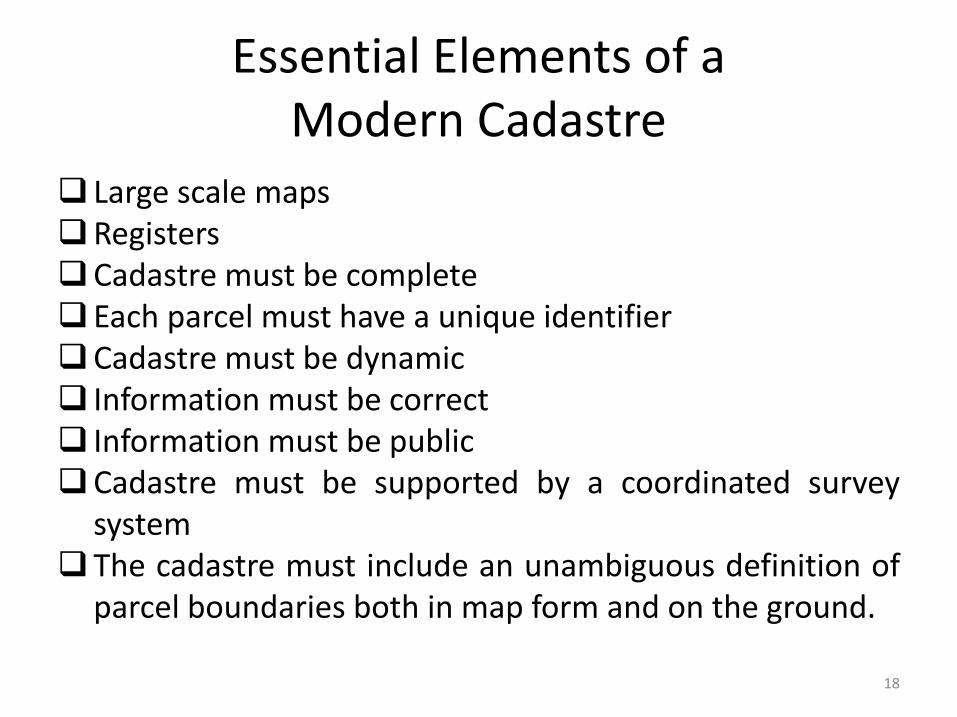
Essential Elements of a Modern Cadastre
Large scale mapsRegistersCadastre must be completeEach parcel must have a unique identifierCadastre must be dynamic Information must be correct Information must be publicCadastre must be supported by a coordinated survey
systemThe cadastre must include an unambiguous definition of
parcel boundaries both in map form and on the ground.
18
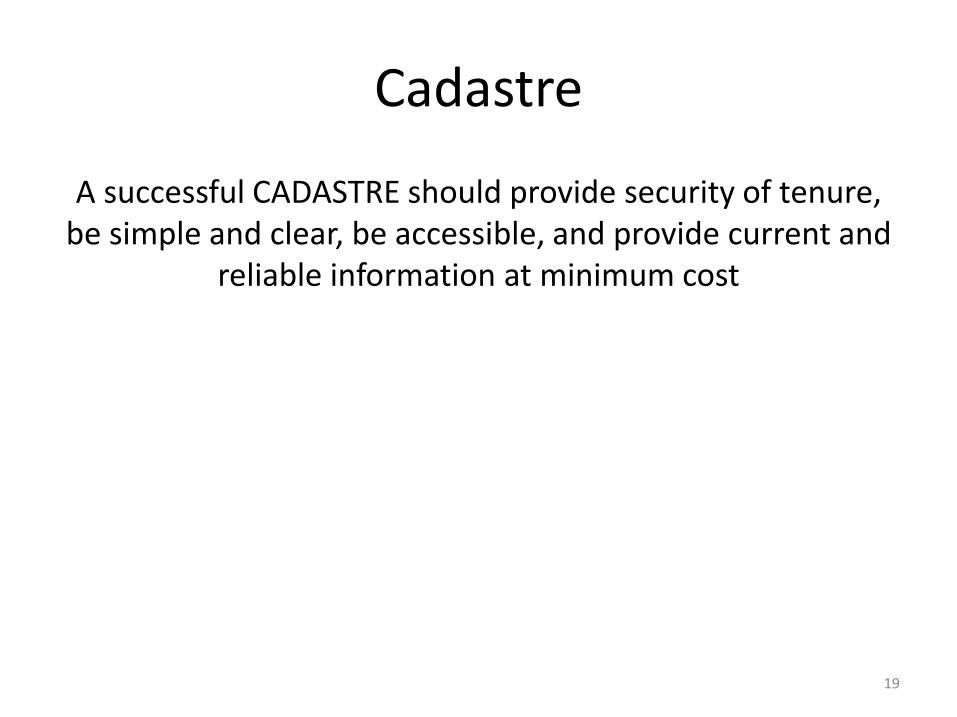
Cadastre
A successful CADASTRE should provide security of tenure, be simple and clear, be accessible, and provide current and
reliable information at minimum cost
19
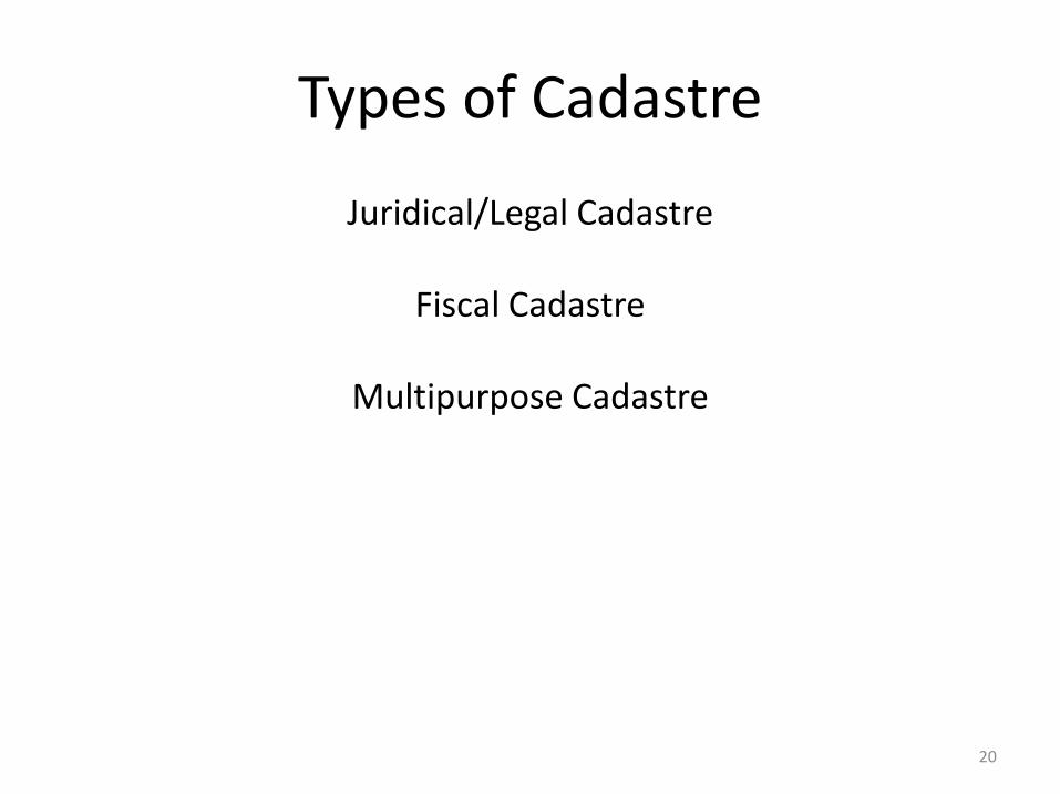
Types of Cadastre
Juridical/Legal Cadastre
Fiscal Cadastre
Multipurpose Cadastre
20
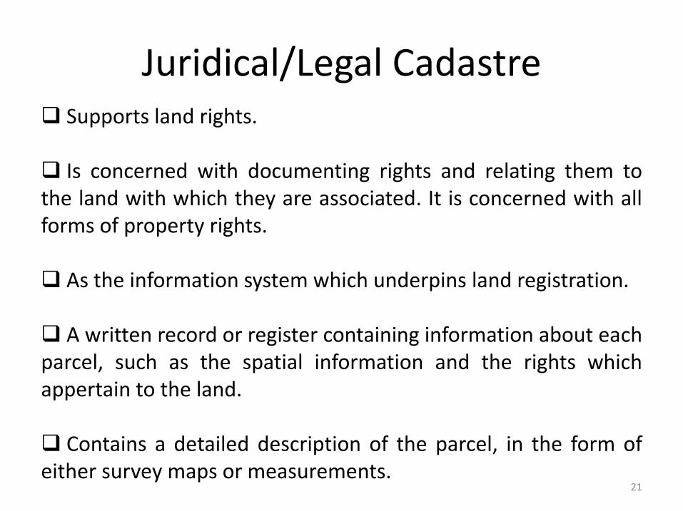
Juridical/Legal Cadastre Supports land rights.
Is concerned with documenting rights and relating them tothe land with which they are associated. It is concerned with allforms of property rights.
As the information system which underpins land registration.
A written record or register containing information about eachparcel, such as the spatial information and the rights whichappertain to the land.
Contains a detailed description of the parcel, in the form ofeither survey maps or measurements.
21

Fiscal Cadastre
An instrument for administering land tax and valuepolicy.
The information required to develop and maintain afiscal cadastre may be collected directly or indirectlythrough surveys or from other sources, for instance detailsof land ownership and their property boundaries.
22
Multipurpose Cadastre
Should be maps showing the location and different typesof physical features.
Concerned with physical attributes such as man-madeobjects and natural features associated with each landparcel, abstractions, surveying and mapping data can alsobe referenced to the parcel.
23
Multipurpose Cadastre Advantages directly beneficial from multipurposecadastre are:
(i) an improved conveyancing system;(ii) an improved cadastral survey system;(iii) improved land use planning, land management and
environment management;(iv) improved management of publicly owned lands,(v) reduction of duplication; and(vi) better control of land transactions.
24
Multipurpose Cadastre
An extension of the basic cadastre, is an essential tool that can include other information from various databases or
registers, and can be adapted for local needs. It is a basis for planning for utilities, land information and development
management.
25
Benefits of Multipurpose Cadastre
A modern multipurpose cadastre can lead to improve:
• Conveyancing system.• Cadastral survey system.• Land use planning and land management.• Sustainable development.• Management of publicly owned lands.• Reduction of duplication.• Control of land transactions.
26
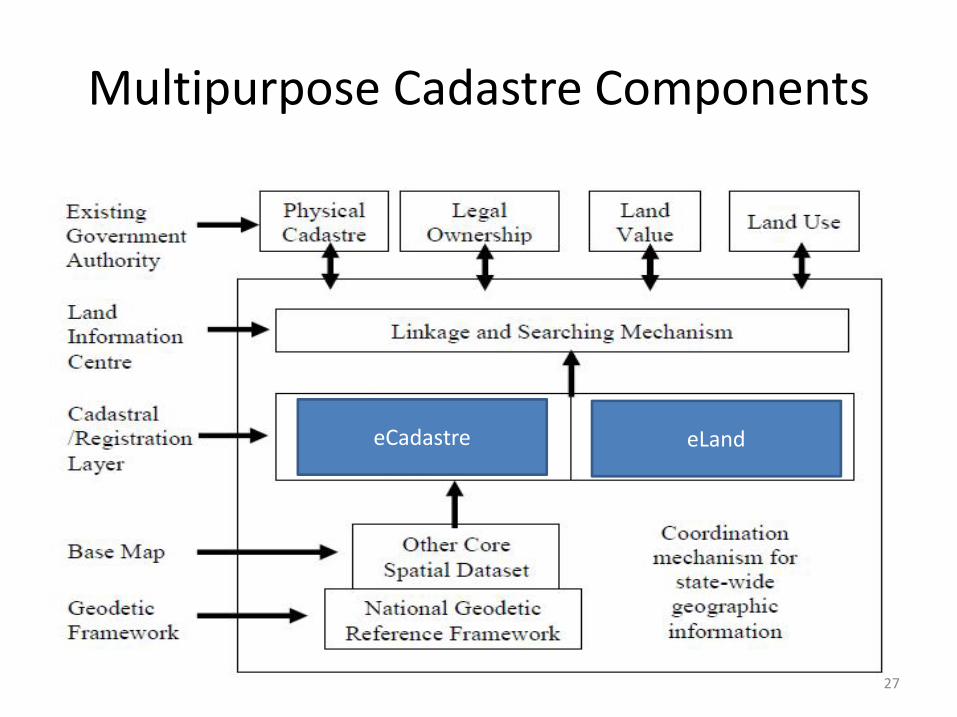
Multipurpose Cadastre Components
eCadastre eLand
27
Cadastral
The basic building block in any land administration system is the cadastral parcel. The cadastre consists of two parts:
• Registers• Maps
28
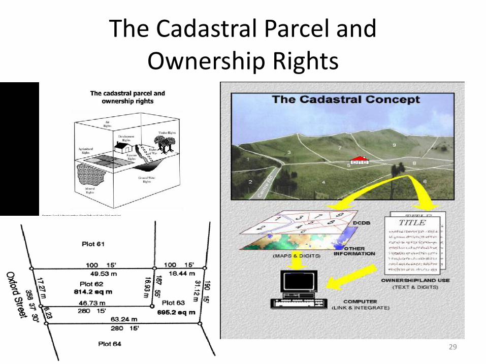
The Cadastral Parcel and Ownership Rights
29
Cadastral Issues
Documentation of informal or customary rights.
Land registration (deeds, title or combinations).
Land titling.
Parcels and properties.
Boundaries (fixed, graphical, general).
Impact of technology.
30
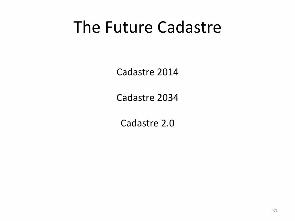
The Future Cadastre
Cadastre 2014
Cadastre 2034
Cadastre 2.0
31
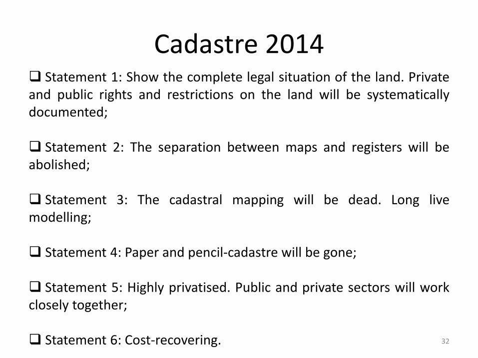
Cadastre 2014 Statement 1: Show the complete legal situation of the land. Privateand public rights and restrictions on the land will be systematicallydocumented;
Statement 2: The separation between maps and registers will beabolished;
Statement 3: The cadastral mapping will be dead. Long livemodelling;
Statement 4: Paper and pencil-cadastre will be gone;
Statement 5: Highly privatised. Public and private sectors will workclosely together;
Statement 6: Cost-recovering. 32

Cadastre 2034
Cadastre 2034 outlines a vision for a broader cadastrewhere information is readily accessible and people haveconfidence in the spatial extent of the various rights,restrictions, and responsibilities related to their land andreal property.
Cadastre 2034 will guide the evolution of jurisdictionalsystems and ensure a coordinated and consistent approachto future policies, legislation, standards, models andresearch; and provide clear direction for the sector as awhole.
33

Cadastre 2034
Fundamental to land and property ownership and issustainably managed;
Multipurpose, truly accessible, easily visualised, and readilyunderstood and used;
Fully integrated with broader legal and social interests onland;
A representation of the real world, which is survey accurate,3-dimensional and dynamic; and
A national cadastre based on common nationwide standards.34
Cadastre 2.0
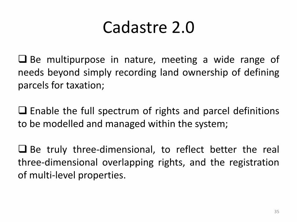
Be multipurpose in nature, meeting a wide range ofneeds beyond simply recording land ownership of definingparcels for taxation;
Enable the full spectrum of rights and parcel definitionsto be modelled and managed within the system;
Be truly three-dimensional, to reflect better the realthree-dimensional overlapping rights, and the registrationof multi-level properties.
35
National Land Code 1965
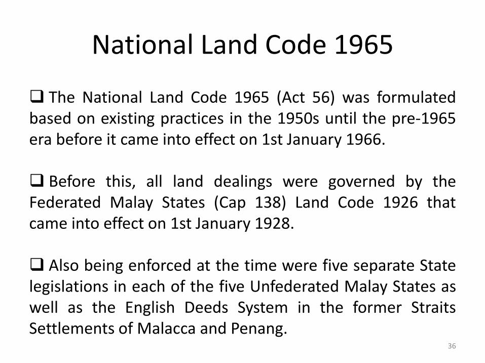
The National Land Code 1965 (Act 56) was formulatedbased on existing practices in the 1950s until the pre-1965era before it came into effect on 1st January 1966.
Before this, all land dealings were governed by theFederated Malay States (Cap 138) Land Code 1926 thatcame into effect on 1st January 1928.
Also being enforced at the time were five separate Statelegislations in each of the five Unfederated Malay States aswell as the English Deeds System in the former StraitsSettlements of Malacca and Penang.
36

DEPARTMENT OF SURVEY AND MAPPING MALAYSIA (JUPEM)
37
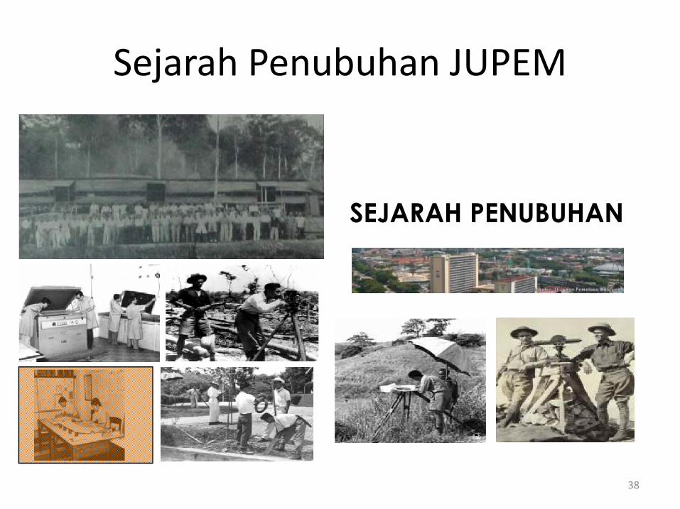
SEJARAH PENUBUHAN
Sejarah Penubuhan JUPEM
38
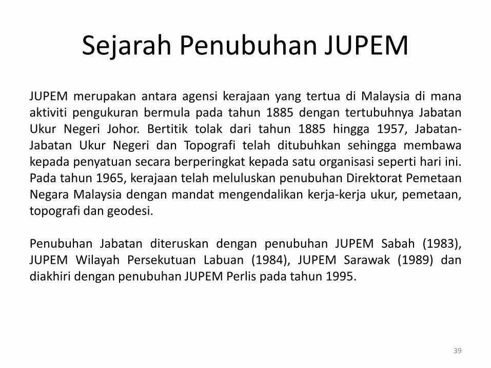
Sejarah Penubuhan JUPEM
JUPEM merupakan antara agensi kerajaan yang tertua di Malaysia di manaaktiviti pengukuran bermula pada tahun 1885 dengan tertubuhnya JabatanUkur Negeri Johor. Bertitik tolak dari tahun 1885 hingga 1957, Jabatan-Jabatan Ukur Negeri dan Topografi telah ditubuhkan sehingga membawakepada penyatuan secara berperingkat kepada satu organisasi seperti hari ini.Pada tahun 1965, kerajaan telah meluluskan penubuhan Direktorat PemetaanNegara Malaysia dengan mandat mengendalikan kerja-kerja ukur, pemetaan,topografi dan geodesi.
Penubuhan Jabatan diteruskan dengan penubuhan JUPEM Sabah (1983),JUPEM Wilayah Persekutuan Labuan (1984), JUPEM Sarawak (1989) dandiakhiri dengan penubuhan JUPEM Perlis pada tahun 1995.
39
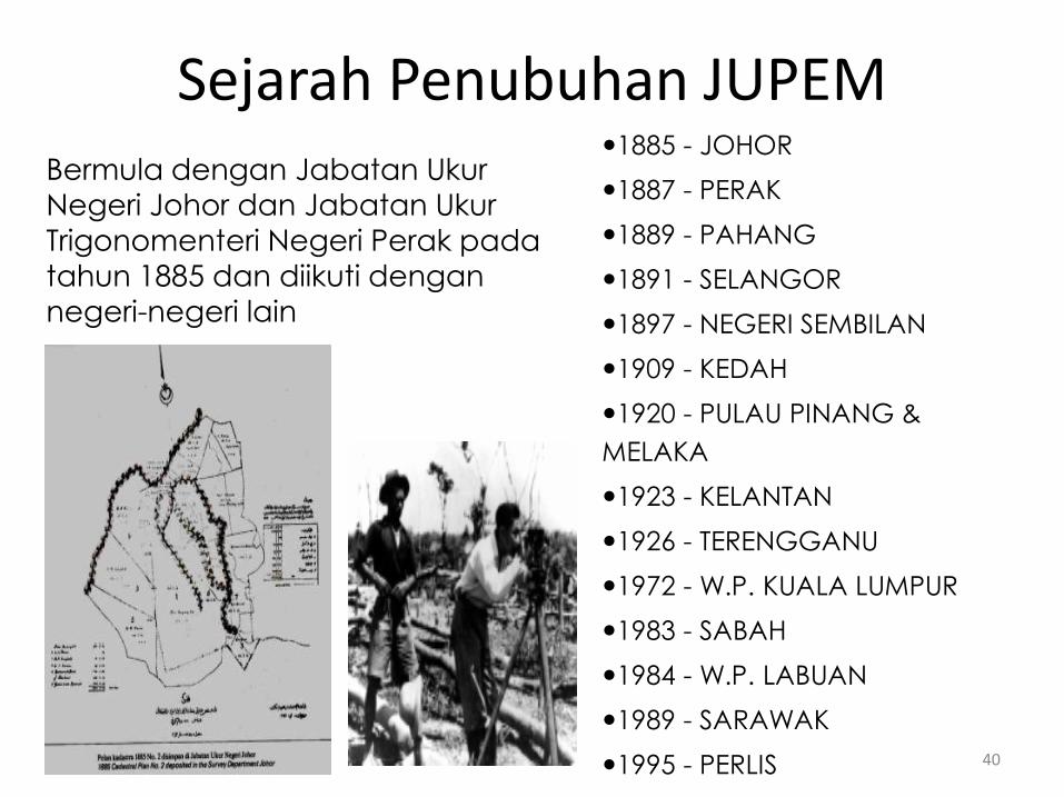
Bermula dengan Jabatan Ukur Negeri Johor dan Jabatan Ukur Trigonomenteri Negeri Perak pada tahun 1885 dan diikuti dengan negeri-negeri lain
1885 - JOHOR
1887 - PERAK
1889 - PAHANG
1891 - SELANGOR
1897 - NEGERI SEMBILAN
1909 - KEDAH
1920 - PULAU PINANG &
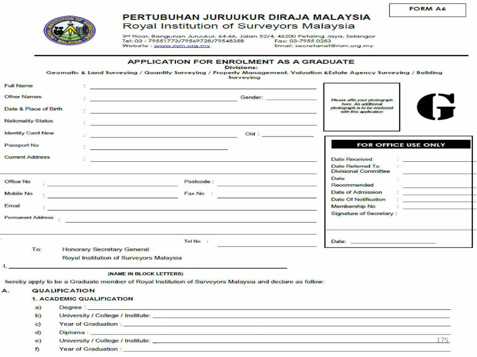
MELAKA
1923 - KELANTAN
1926 - TERENGGANU
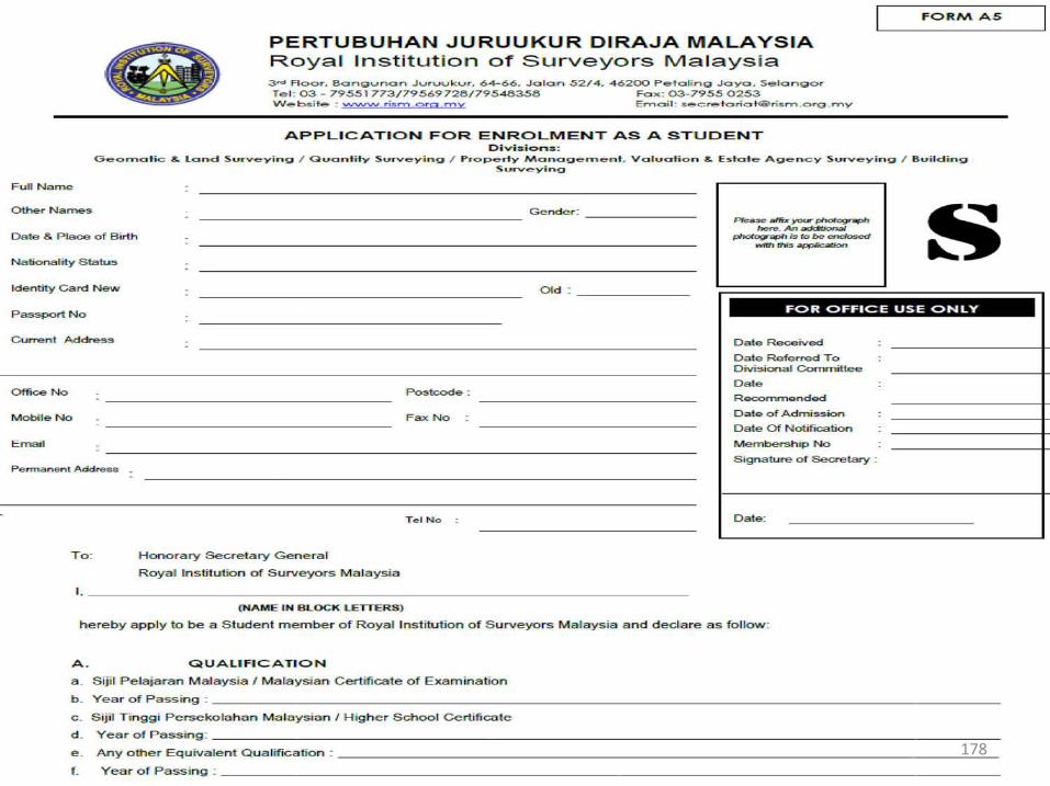
1972 - W.P. KUALA LUMPUR
1983 - SABAH
1984 - W.P. LABUAN
1989 - SARAWAK
1995 - PERLIS
Sejarah Penubuhan JUPEM
40
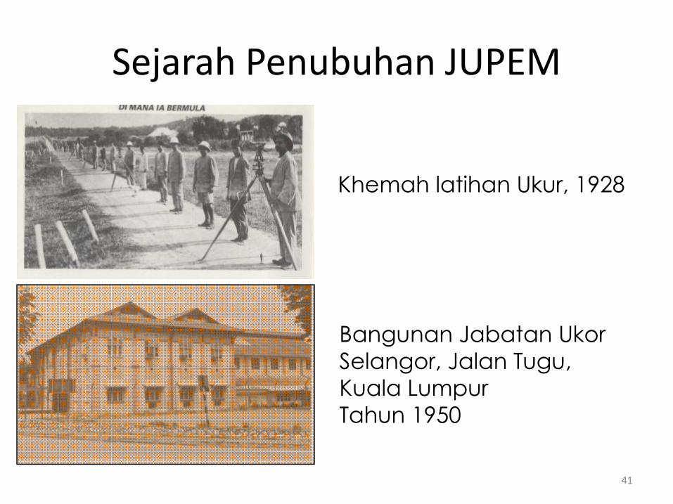
Khemah latihan Ukur, 1928
Bangunan Jabatan Ukor Selangor, Jalan Tugu, Kuala LumpurTahun 1950
Sejarah Penubuhan JUPEM
41
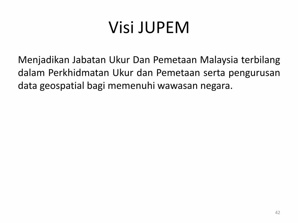
Visi JUPEM
Menjadikan Jabatan Ukur Dan Pemetaan Malaysia terbilangdalam Perkhidmatan Ukur dan Pemetaan serta pengurusandata geospatial bagi memenuhi wawasan negara.
42
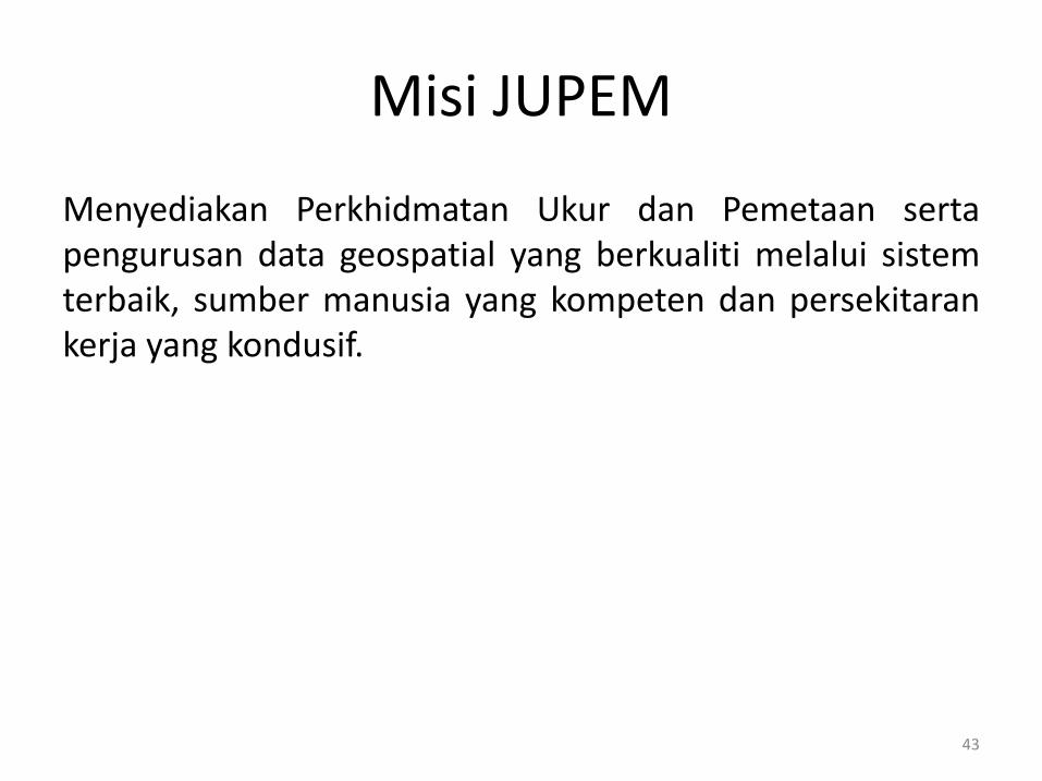
Misi JUPEM
Menyediakan Perkhidmatan Ukur dan Pemetaan sertapengurusan data geospatial yang berkualiti melalui sistemterbaik, sumber manusia yang kompeten dan persekitarankerja yang kondusif.
43
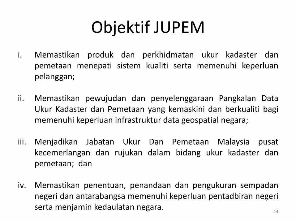
Objektif JUPEM
i. Memastikan produk dan perkhidmatan ukur kadaster danpemetaan menepati sistem kualiti serta memenuhi keperluanpelanggan;
ii. Memastikan pewujudan dan penyelenggaraan Pangkalan DataUkur Kadaster dan Pemetaan yang kemaskini dan berkualiti bagimemenuhi keperluan infrastruktur data geospatial negara;
iii. Menjadikan Jabatan Ukur Dan Pemetaan Malaysia pusatkecemerlangan dan rujukan dalam bidang ukur kadaster danpemetaan; dan
iv. Memastikan penentuan, penandaan dan pengukuran sempadannegeri dan antarabangsa memenuhi keperluan pentadbiran negeriserta menjamin kedaulatan negara.
44
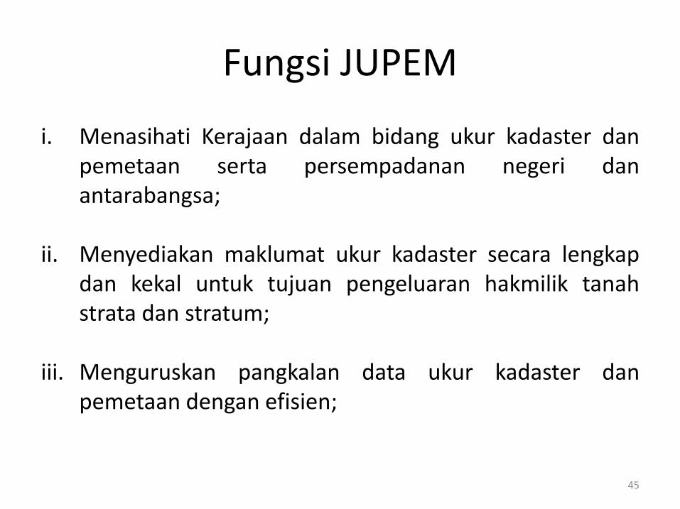
Fungsi JUPEM
i. Menasihati Kerajaan dalam bidang ukur kadaster danpemetaan serta persempadanan negeri danantarabangsa;
ii. Menyediakan maklumat ukur kadaster secara lengkapdan kekal untuk tujuan pengeluaran hakmilik tanahstrata dan stratum;
iii. Menguruskan pangkalan data ukur kadaster danpemetaan dengan efisien;
45
Fungsi JUPEM
iv. Menerbitkan peta-peta topografi, kadaster, tematik danutiliti untuk tujuan perancangan, pengurusan sumberasli, pemuliharaan alam sekitar, pembangunan,pemantauan dan keselamatan;
v. Menerbitkan peta-peta topografi, kadaster, tematik danutiliti untuk tujuan perancangan, pengurusan sumberasli, pemuliharaan alam sekitar, pembangunan,pemantauan dan keselamatan; dan
vi. Menyediakan infrastruktur geodetik bagi ukurankadaster, pemetaan, kejuruteraan dan kajian saintifik.
46
Peranan JUPEM
Jabatan Ukur Dan Pemetaan Malaysia adalah satu-satunyaagensi kerajaan yang menjalankan aktiviti ukuran kawalanmendatar dan menegak untuk komuniti ukur di dalamkerajaan, agensi swasta dan persendirian bagi tujuanpembangunan, keselamatan dan pertahanan negara selainmenubuhkan infrastruktur ukur negara yang lengkap.
47
Peranan Utama JUPEM Mengendalikan aktiviti ukur kadaster.
Mengendalikan aktiviti pemetaan.
Menyediakan infrastruktur asas ukur tanah dan pemetaan.
Pembekal utama maklumat spatial negara.
Penyelidikan dan pembangunan.
Menasihati Kerajaan mengenai dasar-dasar disiplin ukurtanah dan pemetaan.
Sebagai pusat kecemerlangan dan rujukan dalam bidang ukurdan pemetaan 48
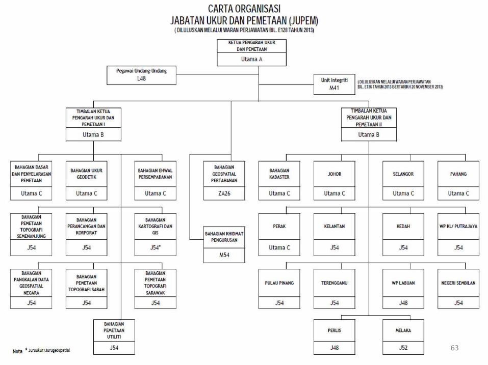
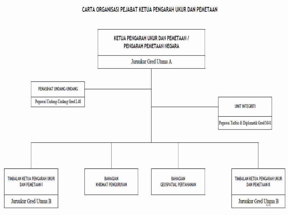
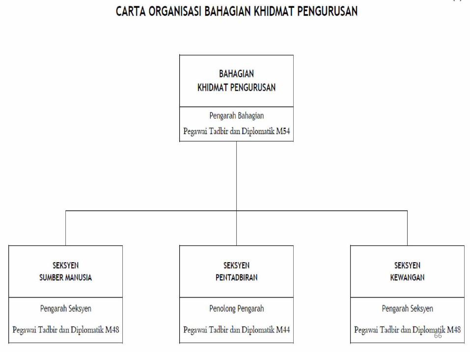
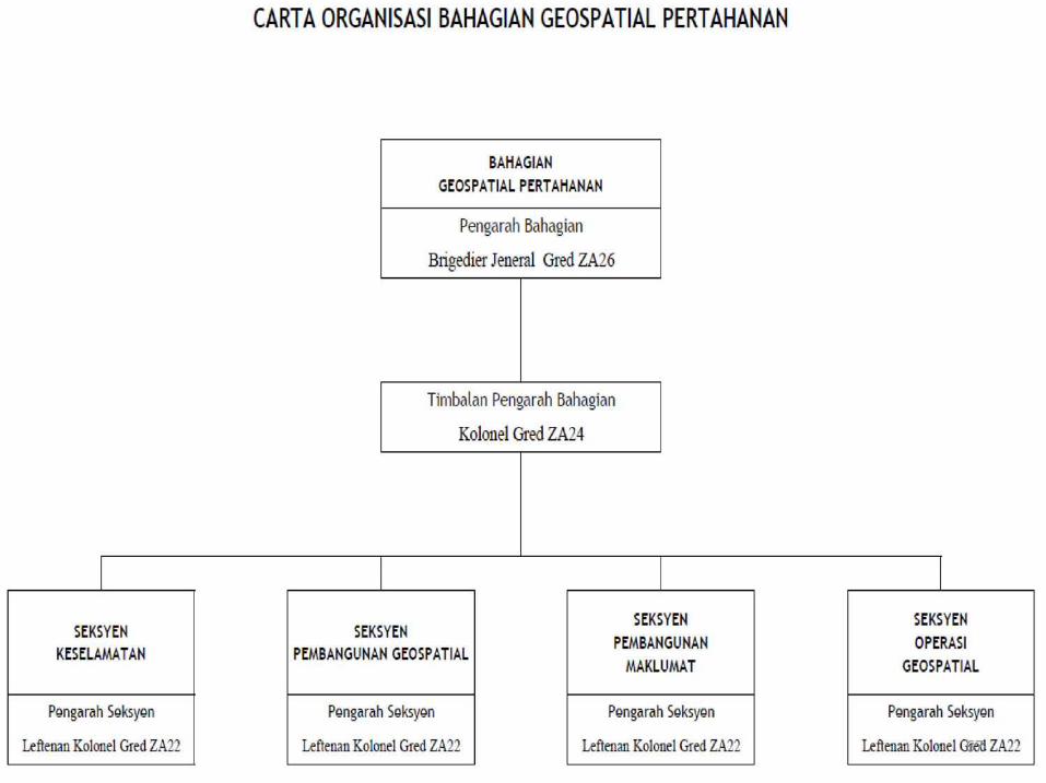
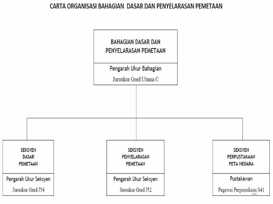
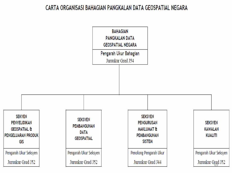
Carta Organisasi JUPEM
Jabatan Ukur dan Pemetaan Malaysia (JUPEM) terletak di bawahKementerian Sumber Asli dan Alam Sekitar (NRE). la diterajui olehKetua Pengarah Ukur dan Pemetaan (KPUP) yang juga selaku PengarahPemetaan Negara dan Pengarah Pemetaan Tentera.
Struktur organisasinya telah dibentuk dalam penyusunan semulastruktur organisasi JUPEM pada Oktober 2013, pada dasarnyaterbahagi kepada dua bahagian iaitu kadaster dan pemetaan.Bahagian-bahagian pemetaan di ketuai oleh Timbalan Ketua PengarahUkur dan Pemetaan I. Manakala Bahagian Kadaster termasuk 13JUPEM Negeri yang diletakkan terus di bawah Timbalan KetuaPengarah Ukur dan Pemetaan II.
Di bawah Pejabat KPUP di hubungkan terus dengan BahagianGeospatial Pertahanan dan Unit Integriti. 49
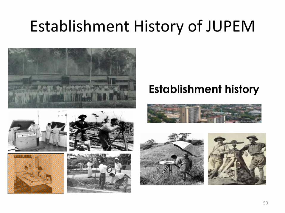
Establishment history
Establishment History of JUPEM
50
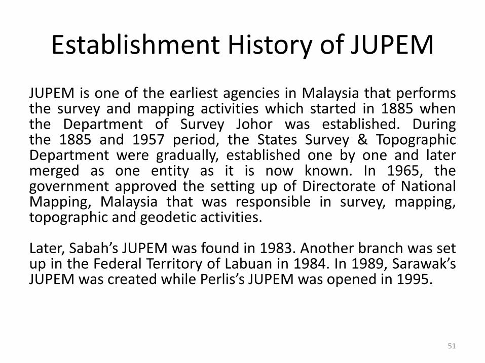
Establishment History of JUPEM
JUPEM is one of the earliest agencies in Malaysia that performsthe survey and mapping activities which started in 1885 whenthe Department of Survey Johor was established. Duringthe 1885 and 1957 period, the States Survey & TopographicDepartment were gradually, established one by one and latermerged as one entity as it is now known. In 1965, thegovernment approved the setting up of Directorate of NationalMapping, Malaysia that was responsible in survey, mapping,topographic and geodetic activities.
Later, Sabah’s JUPEM was found in 1983. Another branch was setup in the Federal Territory of Labuan in 1984. In 1989, Sarawak’sJUPEM was created while Perlis’s JUPEM was opened in 1995.
51
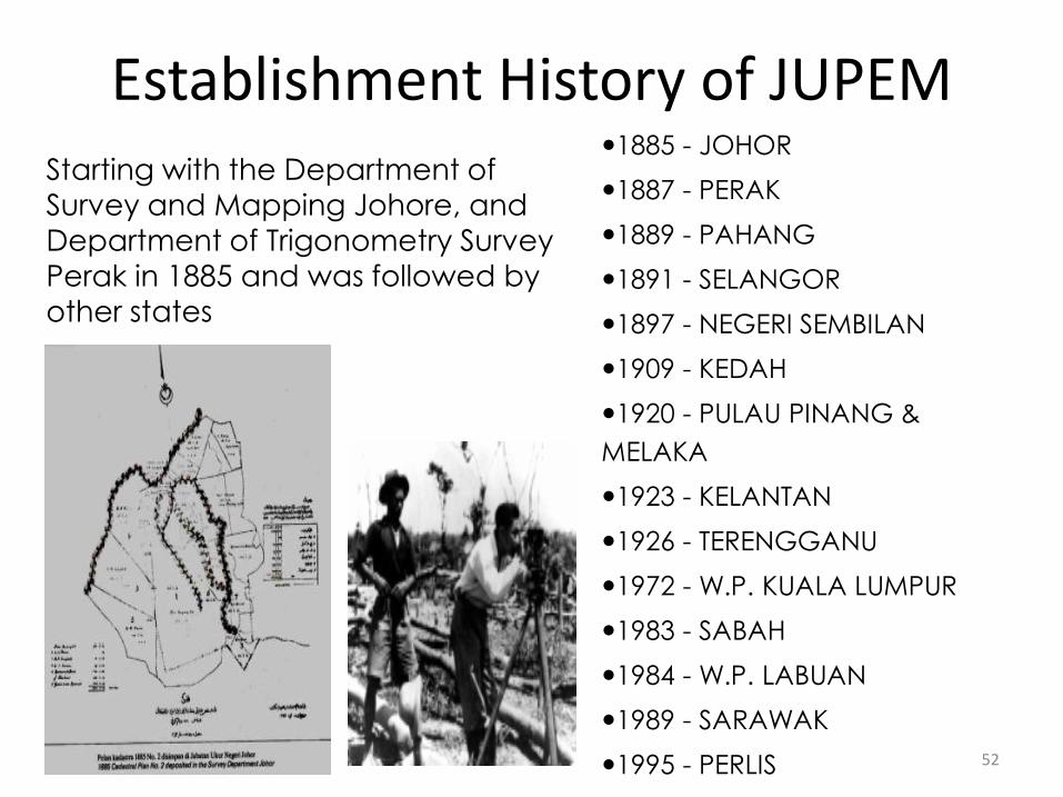
Starting with the Department of Survey and Mapping Johore, and Department of Trigonometry Survey Perak in 1885 and was followed by other states
1885 - JOHOR
1887 - PERAK
1889 - PAHANG
1891 - SELANGOR
1897 - NEGERI SEMBILAN
1909 - KEDAH
1920 - PULAU PINANG &
MELAKA
1923 - KELANTAN
1926 - TERENGGANU
1972 - W.P. KUALA LUMPUR
1983 - SABAH
1984 - W.P. LABUAN
1989 - SARAWAK
1995 - PERLIS
Establishment History of JUPEM
52
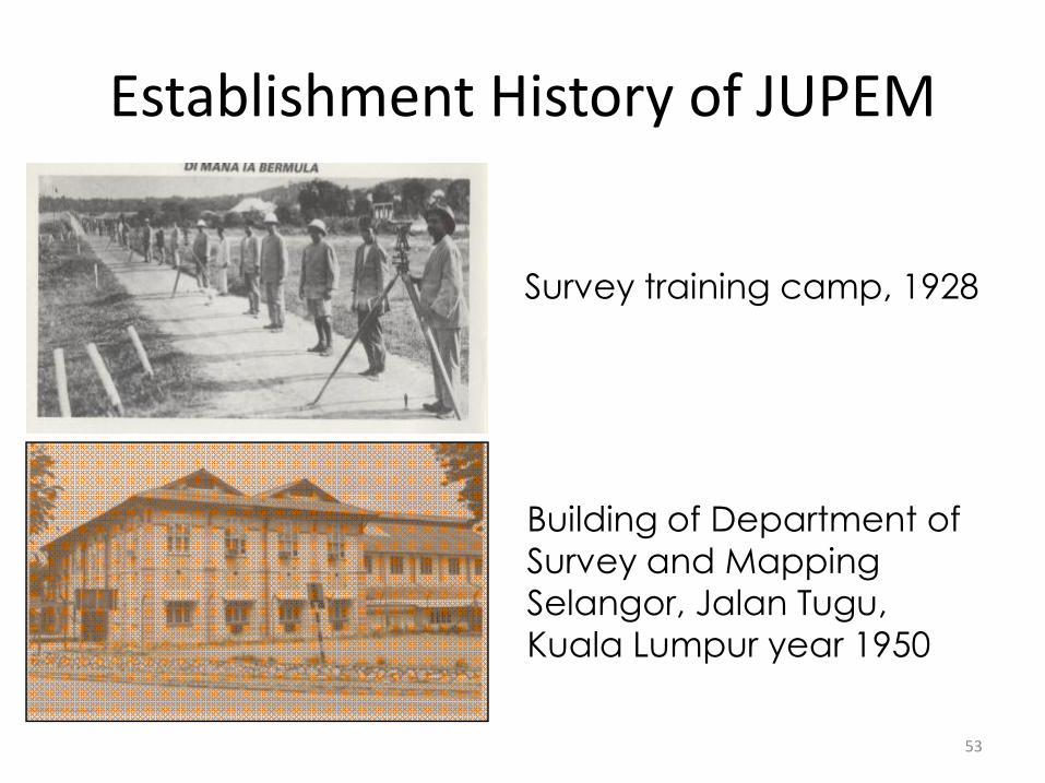
Survey training camp, 1928
Building of Department of Survey and Mapping Selangor, Jalan Tugu, Kuala Lumpur year 1950
Establishment History of JUPEM
53
Vision of JUPEM
Making JUPEM’s an eminent organisation in providingoutstanding survey and mapping services as well asgeospatial data management towards fulfilling the nation’svision.
54
Mision of JUPEM
Providing a quality survey and mapping and services andgeospatial data management via first-rate system,competent human resource and conducive workingenvironment.
55
Objectives of JUPEM
i. To ensure the products and land survey and mappingservices meets the quality acceptance and customer’sneeds.
ii. To ensure a well maintain, up-to-date cadastral and mappingdatabase to meet needs of the national geospatialinfrastructure.
iii. To make JUPEM as an excellent reference centre in the fieldcadastral survey and mapping.
iv. To survey determine, demarcate state and internationalboundaries.
56
Functions of JUPEM
i. To advise the government in the field of cadastral surveyand mapping along with the state and internationalboundaries.
ii. To provide complete and conclusive cadastral informationfor issuing land, strata and startum titles.
iii. To manage efficiently the cadastral and mapping databases.iv. To publish photographical, cadastral, thematic and utility
maps for the purposes of planning, management of naturalenvironment resources, preservation of environment,development, surveillance and security.
v. To provide geodetic infrastructure for the purposes ofcadastre survey, mapping, engineering and scientificresearch.
57
Roles of JUPEM
JUPEM is responsible for the country’s survey and mappingactivities and entrusted in such activities so as to safeguardcountry’s sovereignty. Department’s activities are vital asthey are to spur the country’s socio-economicdevelopment.
58
Main Roles of JUPEM To operate cadastral survey activities.
To operate mapping activities.
Providing basic survey and mapping infrastructure.
Main provider of spatial information
Research and development.
Advice the goverment of the discipline of survey andmapping.
As a center of excellence and reference in the field of surveyand mapping. 59
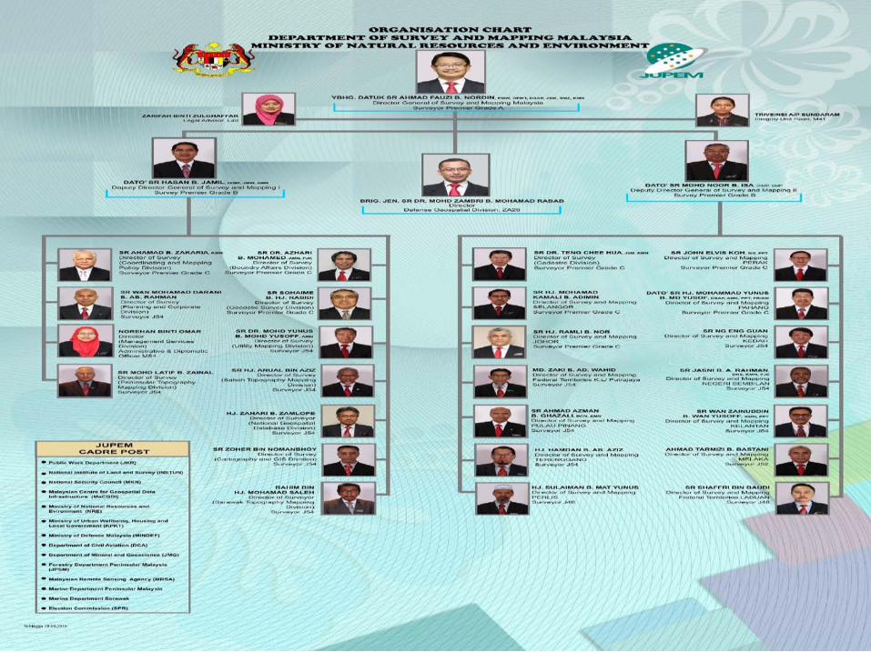
Organisation Chart of JUPEM
Jabatan Ukur dan Pemetaan Malaysia (JUPEM) terletak di bawahKementerian Sumber Asli dan Alam Sekitar (NRE). la diterajui olehKetua Pengarah Ukur dan Pemetaan (KPUP) yang juga selaku PengarahPemetaan Negara dan Pengarah Pemetaan Tentera.
Struktur organisasinya telah dibentuk dalam penyusunan semulastruktur organisasi JUPEM pada Oktober 2013, pada dasarnyaterbahagi kepada dua bahagian iaitu kadaster dan pemetaan.Bahagian-bahagian pemetaan di ketuai oleh Timbalan Ketua PengarahUkur dan Pemetaan I. Manakala Bahagian Kadaster termasuk 13JUPEM Negeri yang diletakkan terus di bawah Timbalan KetuaPengarah Ukur dan Pemetaan II.
Di bawah Pejabat KPUP di hubungkan terus dengan BahagianGeospatial Pertahanan dan Unit Integriti. 60
Organisation Chart of JUPEM
Department of Survey and Mapping Malaysia (JUPEM) is under theMinistry of Natural Resources and Environment (NRE). It was led by theDirector General of Survey and Mapping (DG) who is also the Director ofNational Mapping and Director of Military Mapping.
This organizational structure has been set up in the organizationalrestructuring in October 2013, it is basically divided into two division, i.e.cadastre and mapping. Mapping division headed by Deputy DirectorGeneral of Survey and Mapping I. While cadastre division and 13 JUPEMStates are placed directly under the Deputy Director General of Surveyand Mapping II.
Di bawah Pejabat KPUP di hubungkan terus dengan BahagianGeospatial Pertahanan dan Unit Integriti. Director General of Survey andMapping office is connected directly with the Defense Geospatial andIntegrity Unit. 61
62
63
64
65
66
67
68
69
70
71
72
73

74
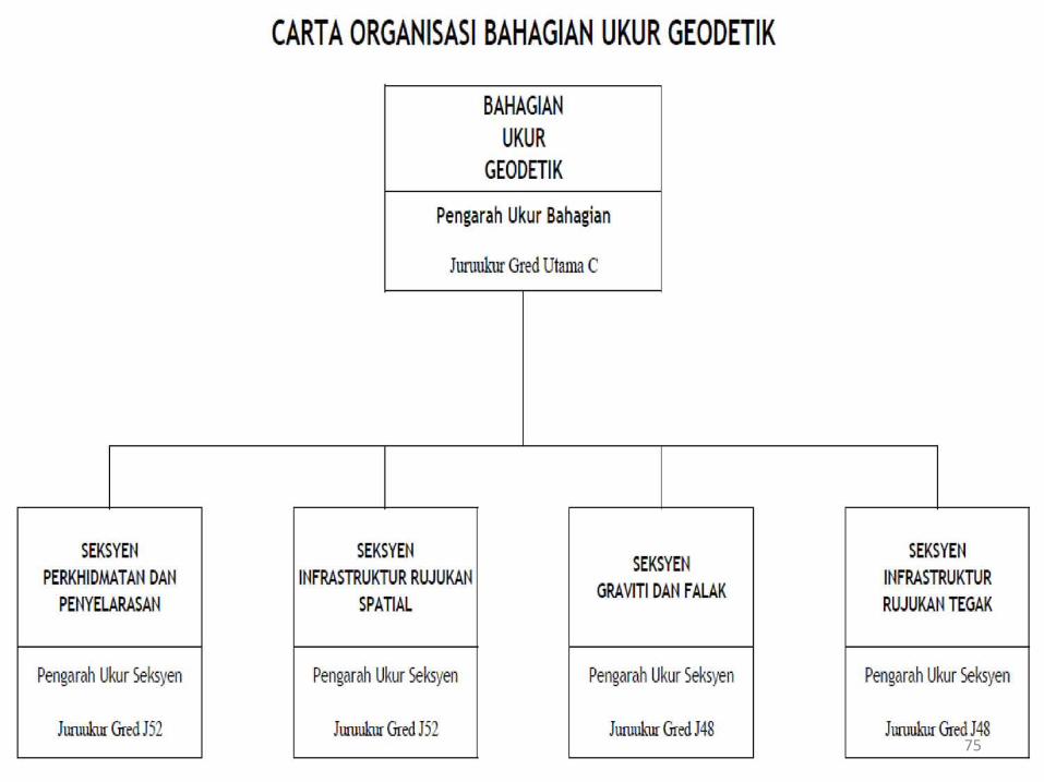
75
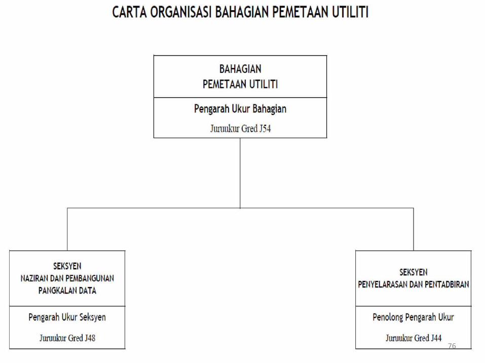
76
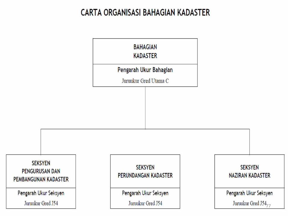
77
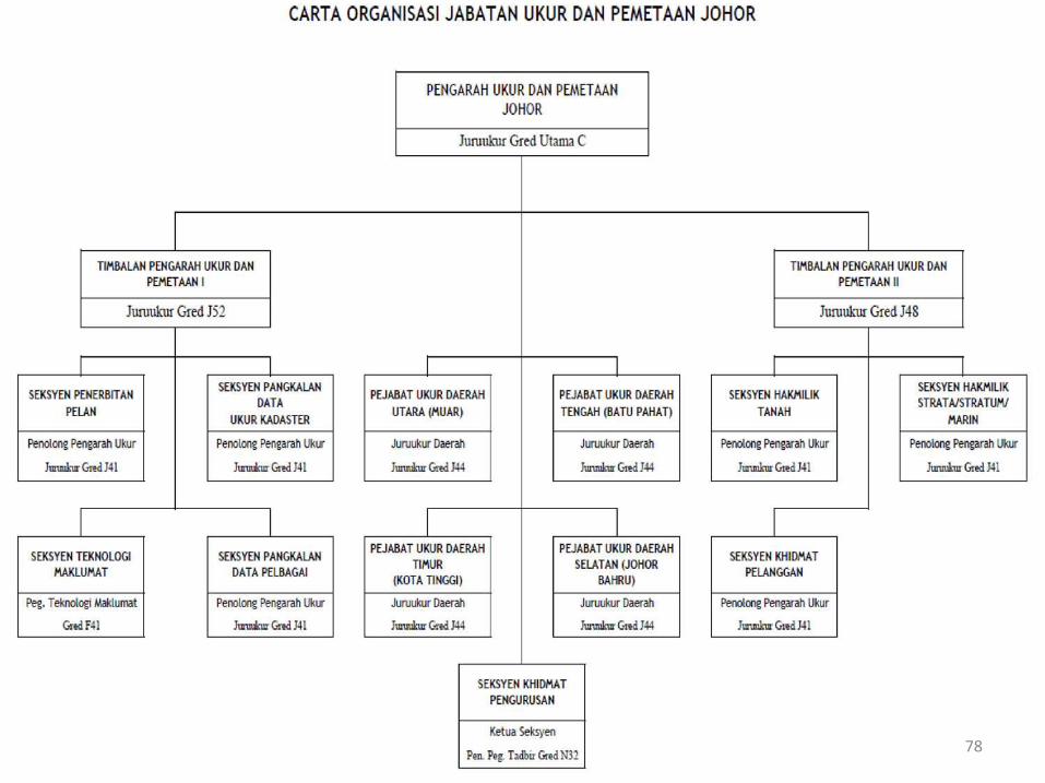
78
79
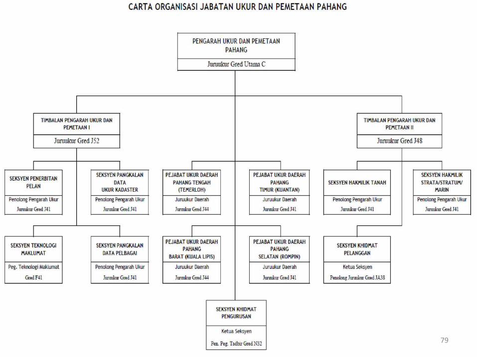
80
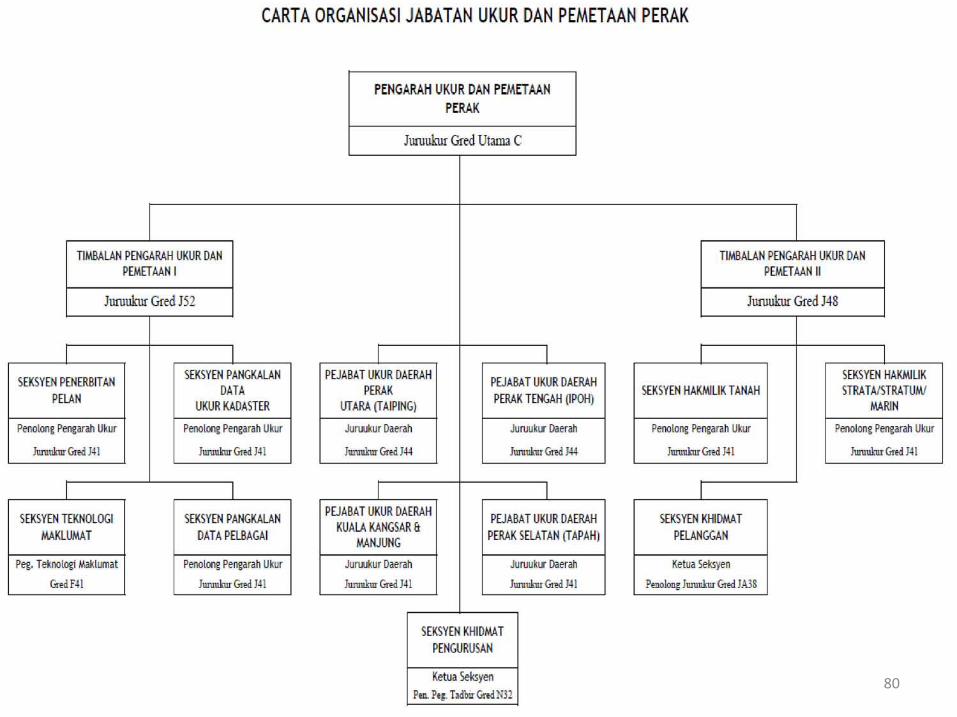
81
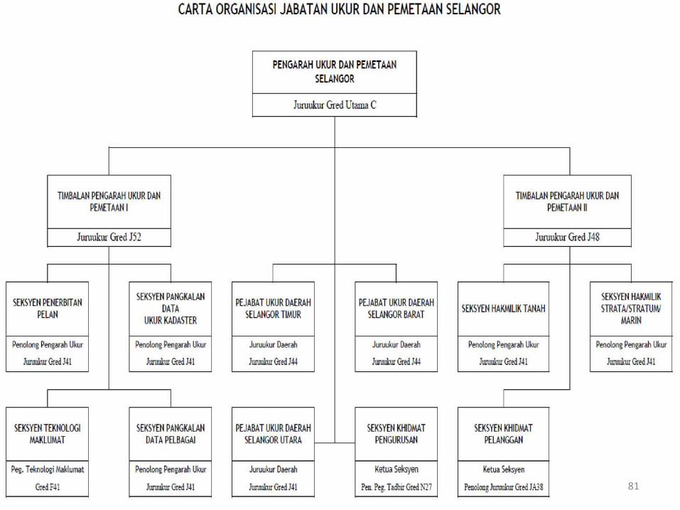
82
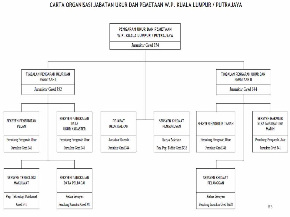
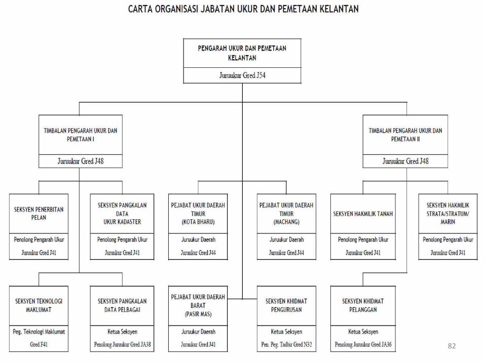
83
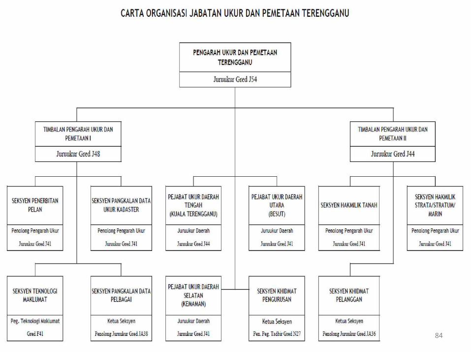
84
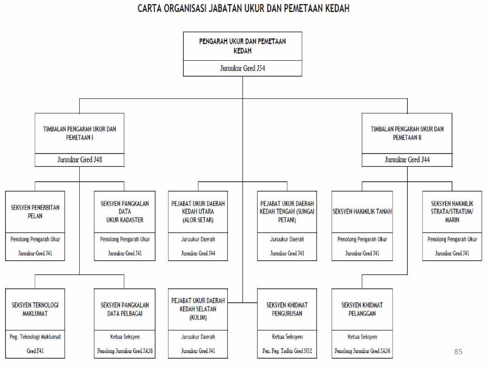
85
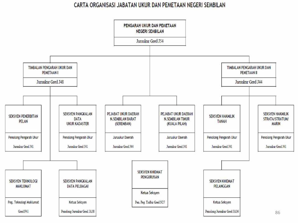
86
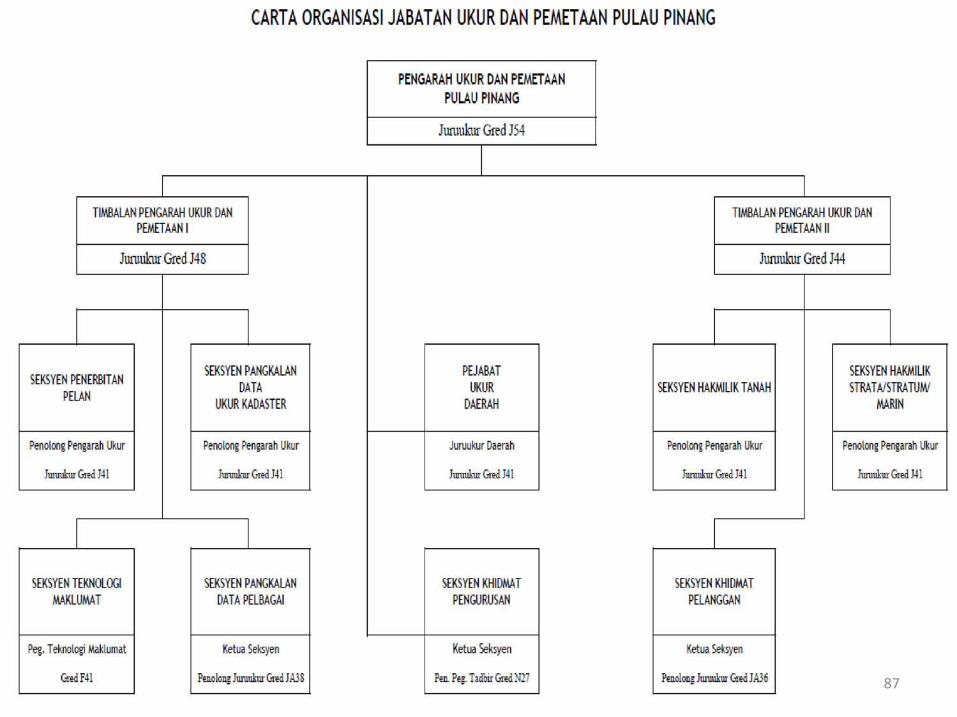
87
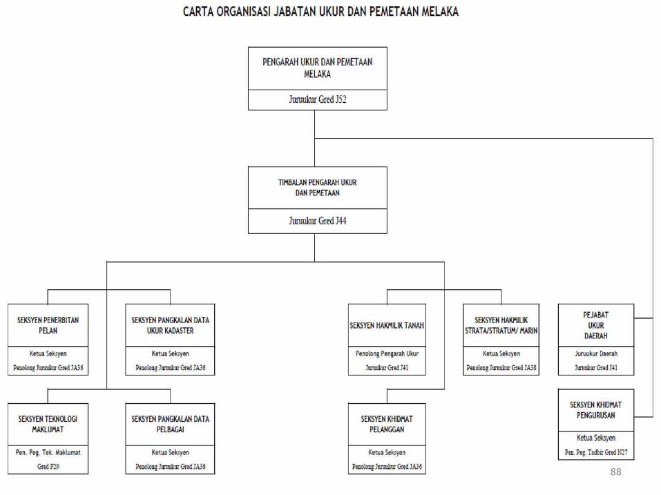
88
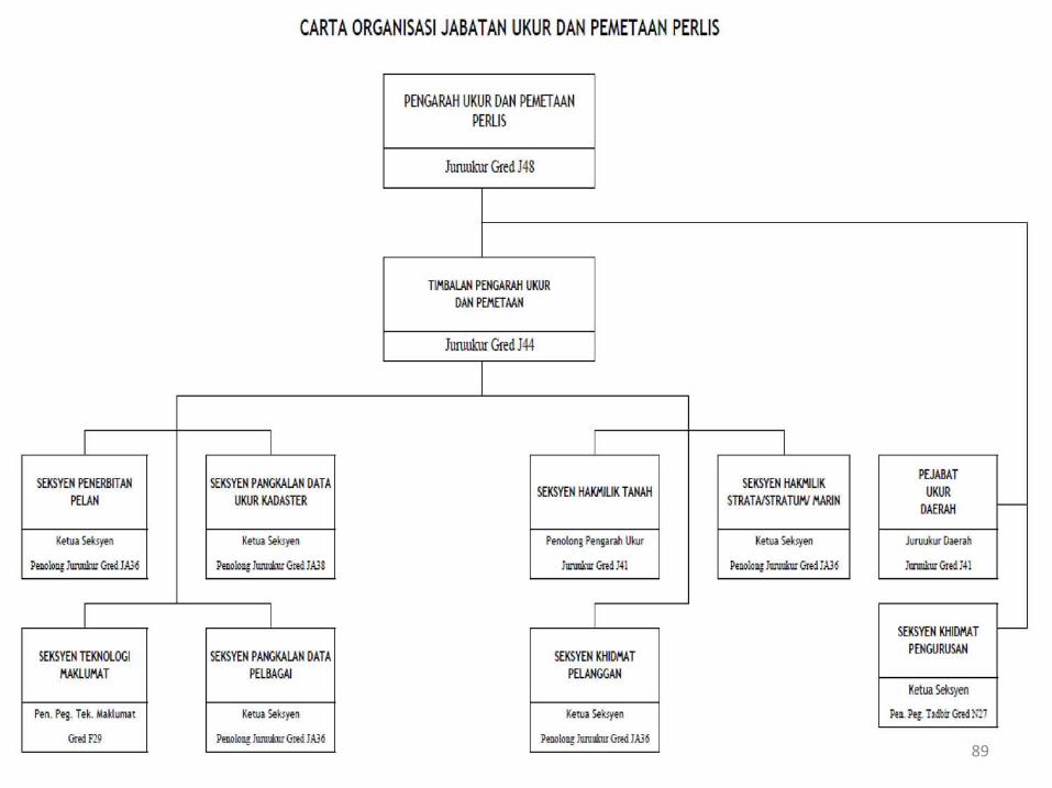
89
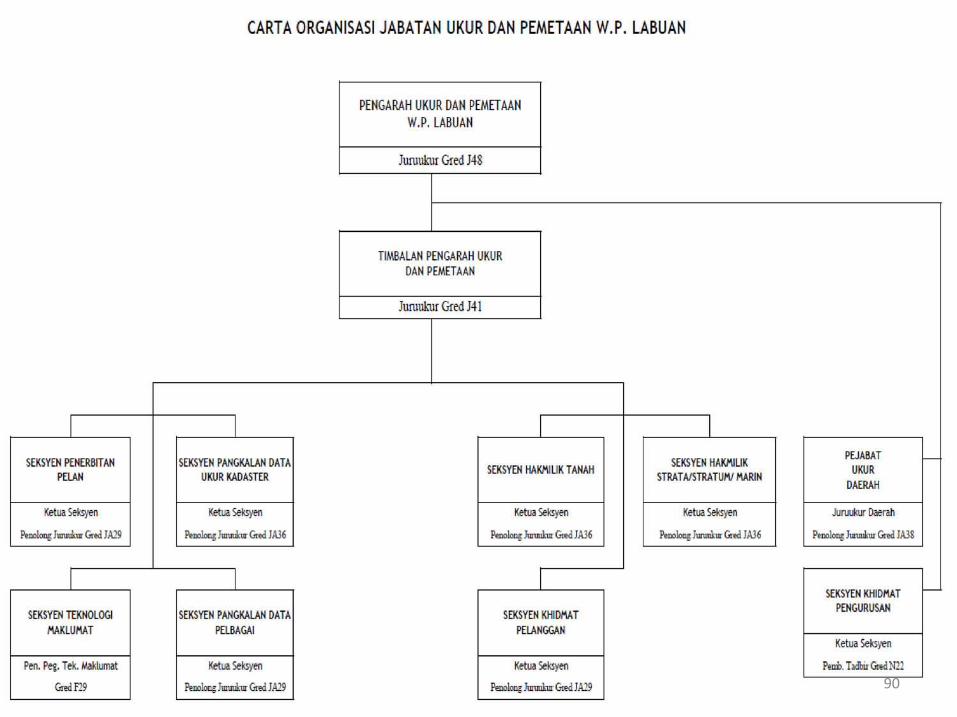
90
91
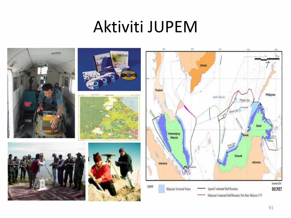
Aktiviti JUPEM
Aktiviti JUPEM
Aktiviti utama Jabatan Ukur Dan Pemetaan Malaysiadalam menyediakan infrastruktur ukur di seluruh negara,adalah:
i. Aktiviti GEOSPATIAL PERTAHANAN
ii. Aktiviti UKUR PEMETAAN
iii. Aktiviti UKUR KADASTER
92
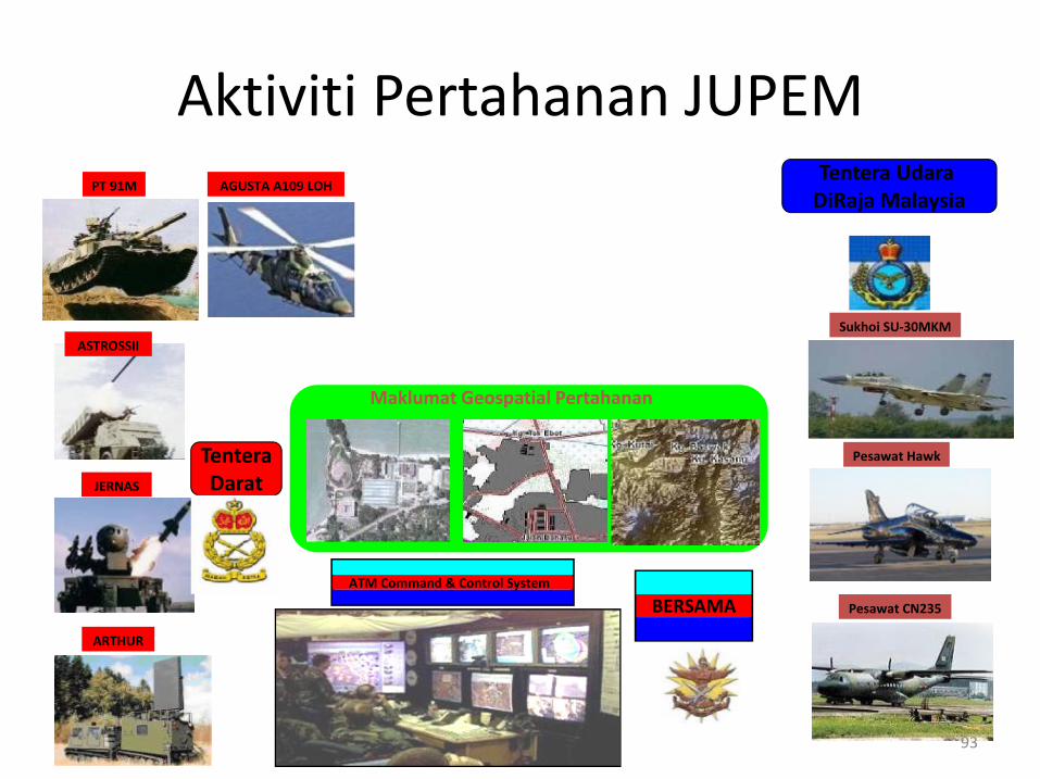
ATM Command & Control System
Tentera Udara DiRaja Malaysia
TenteraDarat
Maklumat Geospatial Pertahanan
ASTROSSII
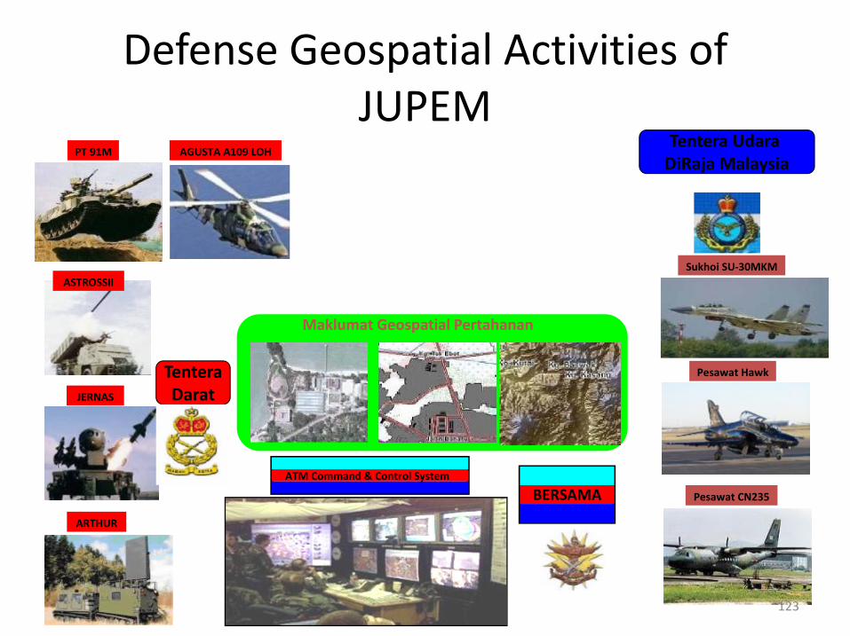
JERNAS
ARTHUR
PT 91M
Sukhoi SU-30MKM
Pesawat Hawk
Pesawat CN235BERSAMA
AGUSTA A109 LOH
93
Aktiviti Pertahanan JUPEM
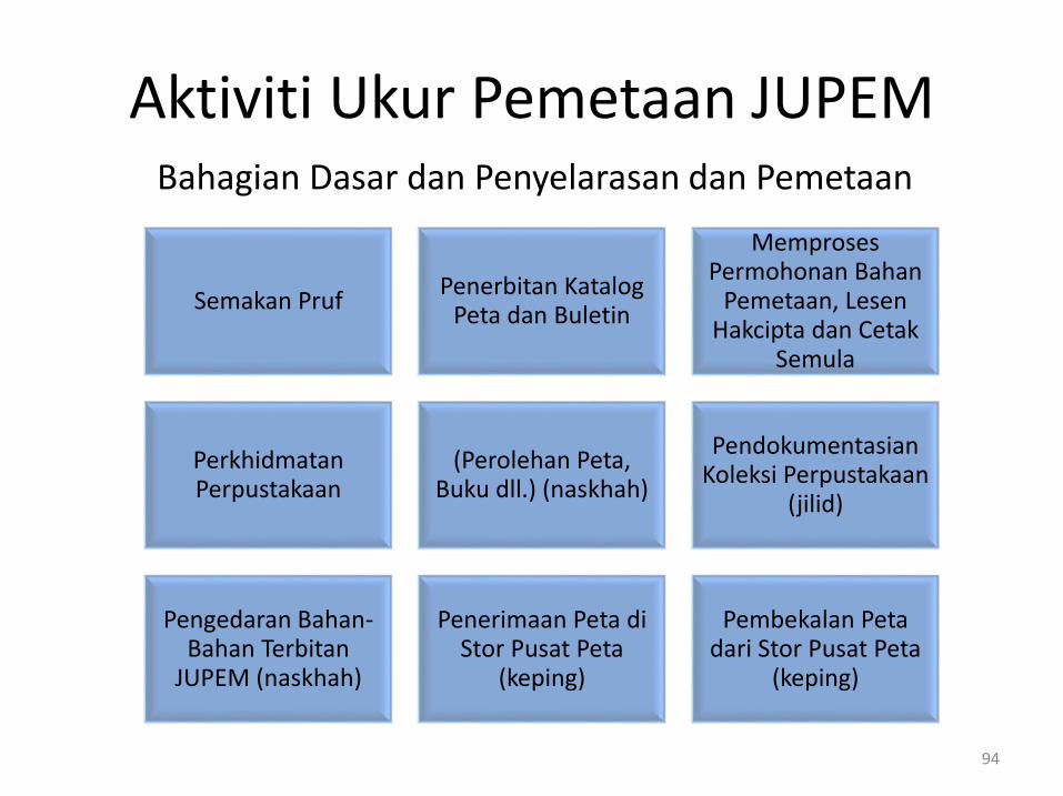
Bahagian Dasar dan Penyelarasan dan Pemetaan
Semakan PrufPenerbitan Katalog
Peta dan Buletin
Memproses Permohonan Bahan
Pemetaan, Lesen Hakcipta dan Cetak
Semula
Perkhidmatan Perpustakaan
(Perolehan Peta, Buku dll.) (naskhah)
Pendokumentasian Koleksi Perpustakaan
(jilid)
Pengedaran Bahan-Bahan Terbitan
JUPEM (naskhah)
Penerimaan Peta di Stor Pusat Peta
(keping)
Pembekalan Peta dari Stor Pusat Peta
(keping)
94
Aktiviti Ukur Pemetaan JUPEM
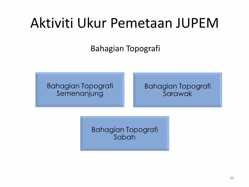
Bahagian Topografi
Bahagian Topografi Semenanjung
Bahagian Topografi Sarawak
Bahagian Topografi Sabah
95
Aktiviti Ukur Pemetaan JUPEM
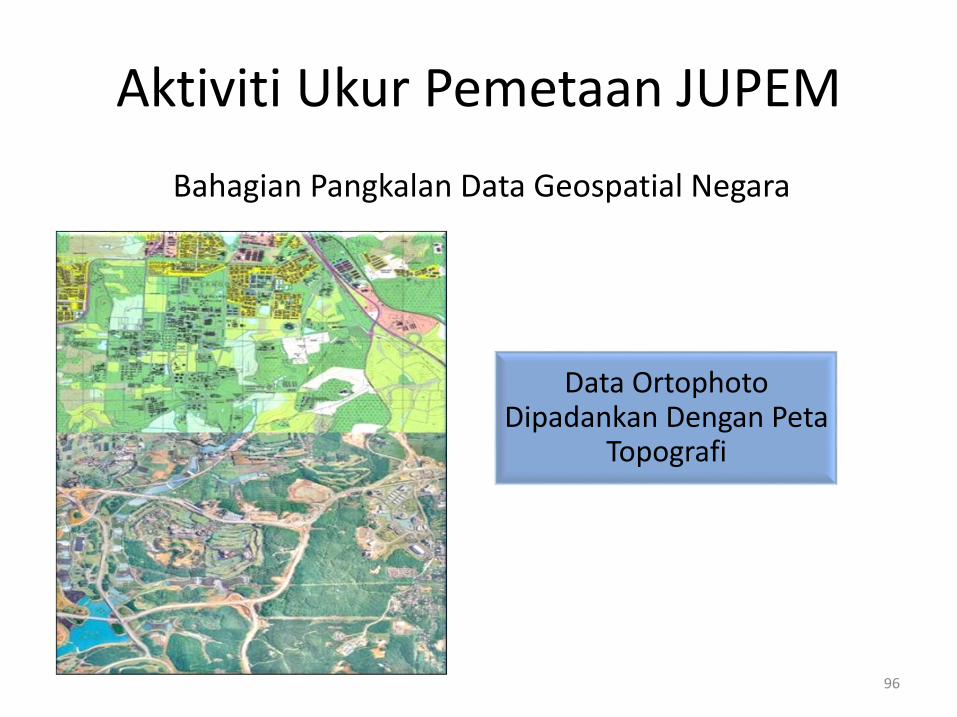
Bahagian Pangkalan Data Geospatial Negara
Data Ortophoto Dipadankan Dengan Peta
Topografi
96
Aktiviti Ukur Pemetaan JUPEM

Penawanan Data Melalui Foto Udara
97
Bahagian Pangkalan Data Geospatial Negara
Aktiviti Ukur Pemetaan JUPEM
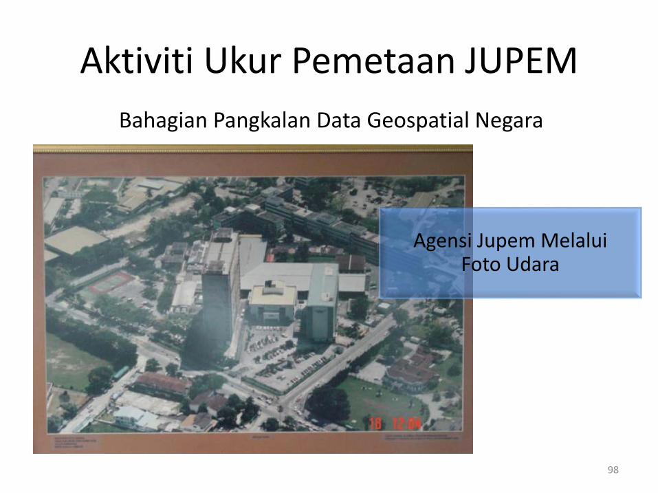
Agensi Jupem Melalui Foto Udara
98
Bahagian Pangkalan Data Geospatial Negara
Aktiviti Ukur Pemetaan JUPEM
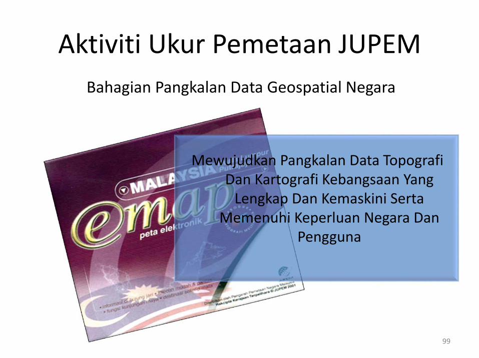
Mewujudkan Pangkalan Data Topografi Dan Kartografi Kebangsaan Yang
Lengkap Dan Kemaskini Serta Memenuhi Keperluan Negara Dan
Pengguna
99
Bahagian Pangkalan Data Geospatial Negara
Aktiviti Ukur Pemetaan JUPEM

Pelbagai Utiliti Bawah Tanah
100
Bahagian Pemetaan Utiliti
Aktiviti Ukur Pemetaan JUPEM
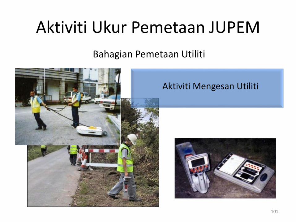
Aktiviti Mengesan Utiliti
101
Bahagian Pemetaan Utiliti
Aktiviti Ukur Pemetaan JUPEM
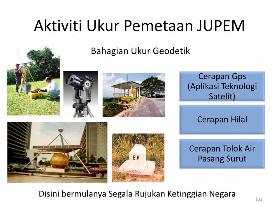
Cerapan Gps (Aplikasi Teknologi
Satelit)
Cerapan Hilal
Cerapan Tolok Air Pasang Surut
Disini bermulanya Segala Rujukan Ketinggian Negara102
Bahagian Ukur Geodetik
Aktiviti Ukur Pemetaan JUPEM
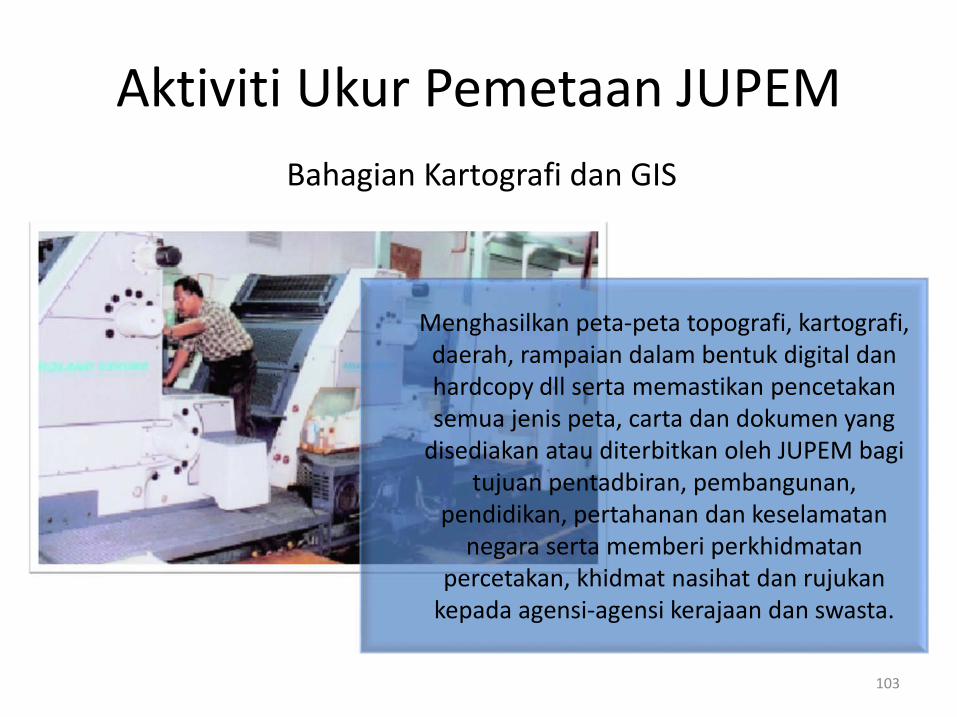
Menghasilkan peta-peta topografi, kartografi, daerah, rampaian dalam bentuk digital dan hardcopy dll serta memastikan pencetakan semua jenis peta, carta dan dokumen yang
disediakan atau diterbitkan oleh JUPEM bagi tujuan pentadbiran, pembangunan,
pendidikan, pertahanan dan keselamatan negara serta memberi perkhidmatan
percetakan, khidmat nasihat dan rujukan kepada agensi-agensi kerajaan dan swasta.
103
Bahagian Kartografi dan GIS
Aktiviti Ukur Pemetaan JUPEM
Persempadan Maritim Antarabangsa
Persempadan Darat
( Negeri/Antarabangsa )
104
Bahagian Ehwal Persempadanan
Aktiviti Ukur Pemetaan JUPEM
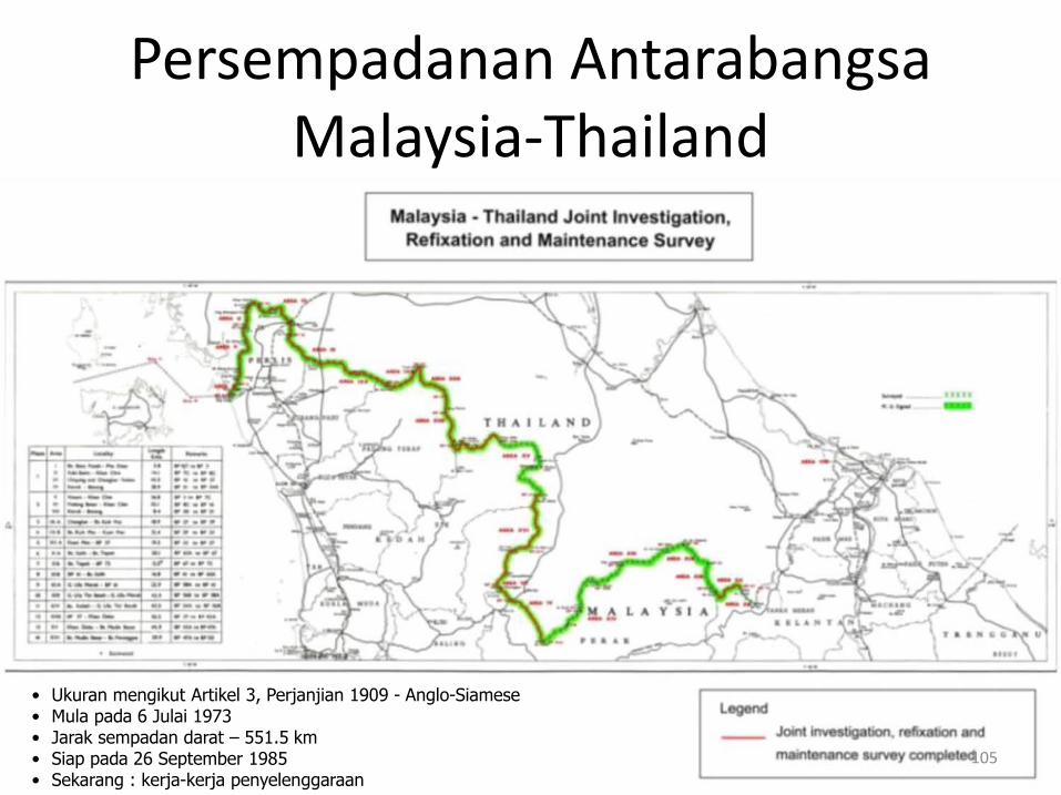
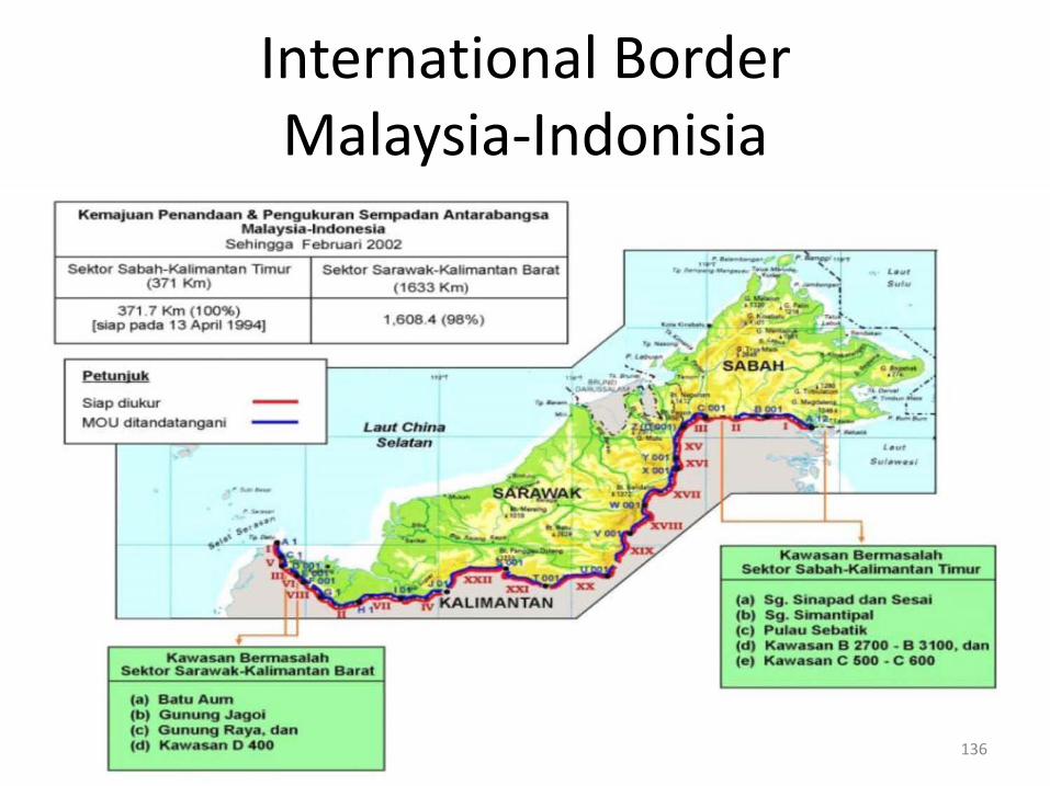
• Ukuran mengikut Artikel 3, Perjanjian 1909 - Anglo-Siamese• Mula pada 6 Julai 1973• Jarak sempadan darat – 551.5 km• Siap pada 26 September 1985• Sekarang : kerja-kerja penyelenggaraan
105
Persempadanan AntarabangsaMalaysia-Thailand
106
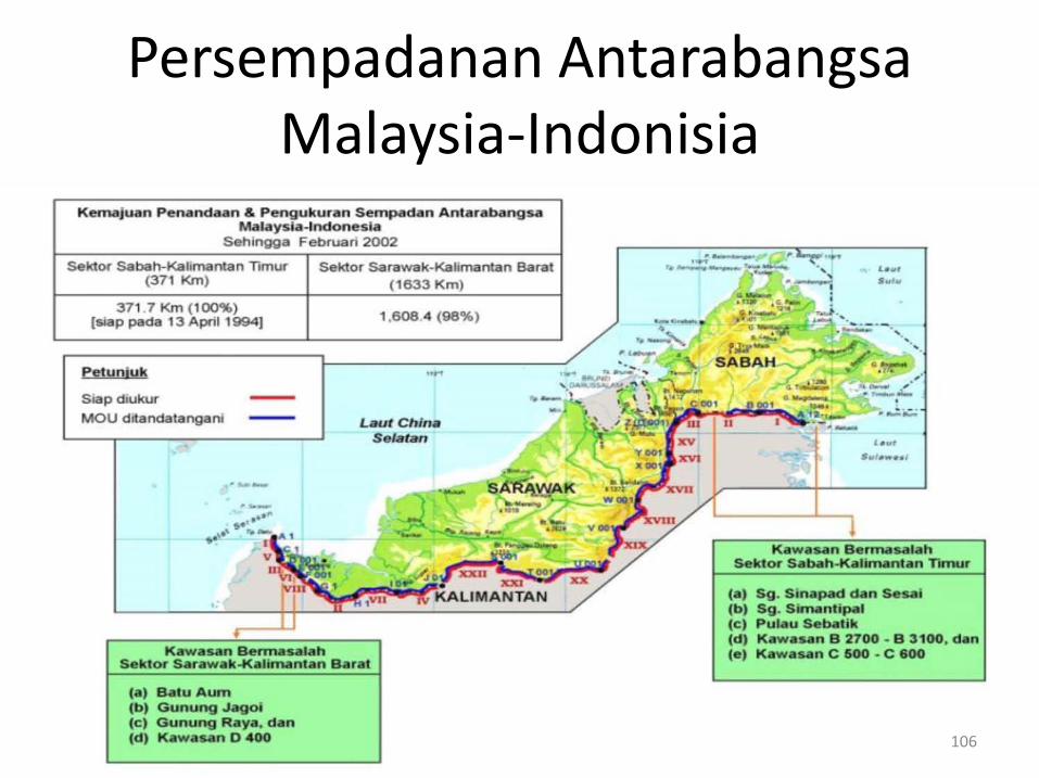
Persempadanan AntarabangsaMalaysia-Indonisia
107
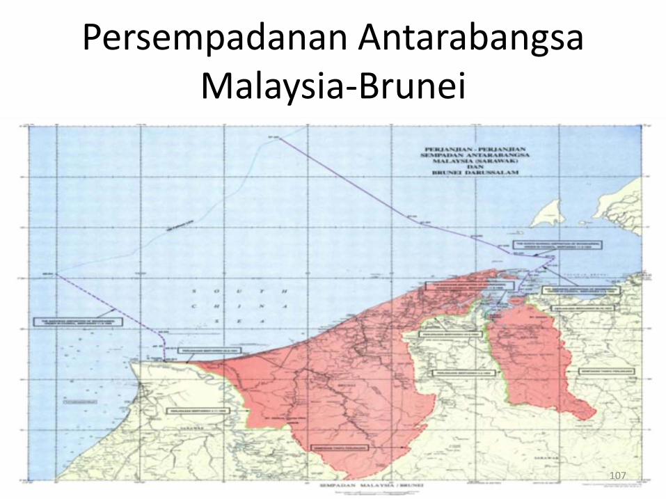
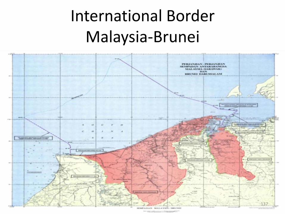
Persempadanan AntarabangsaMalaysia-Brunei
108
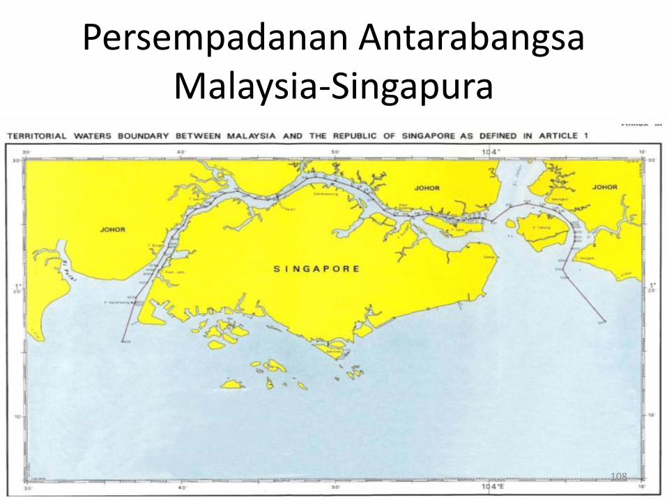
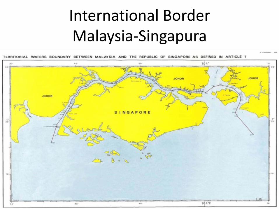
Persempadanan AntarabangsaMalaysia-Singapura
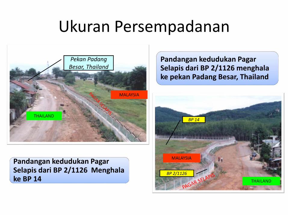
Pandangan kedudukan Pagar Selapis dari BP 2/1126 menghala ke pekan Padang Besar, Thailand
Pandangan kedudukan Pagar Selapis dari BP 2/1126 Menghala ke BP 14 THAILAND
MALAYSIA
MALAYSIA
THAILAND
Pekan Padang Besar, Thailand
BP 2/1126
BP 14
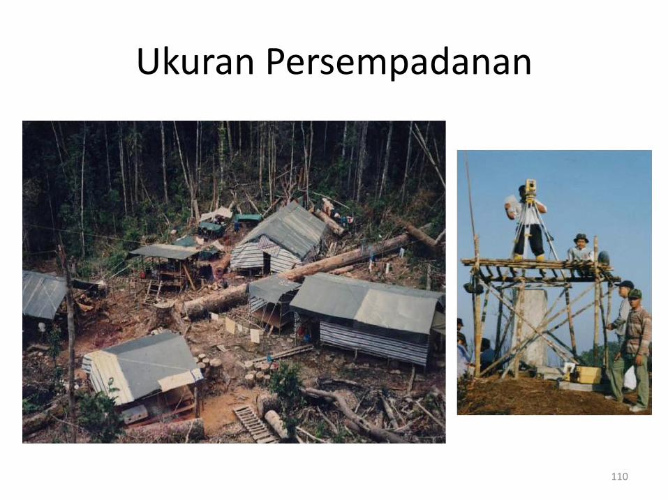
Ukuran Persempadanan
110
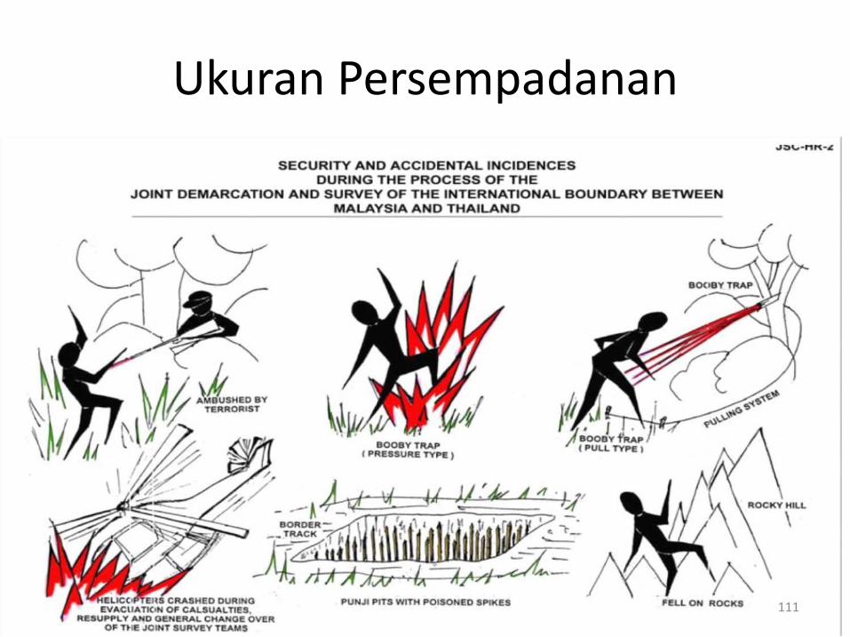
Ukuran Persempadanan
111
Ukuran Persempadanan

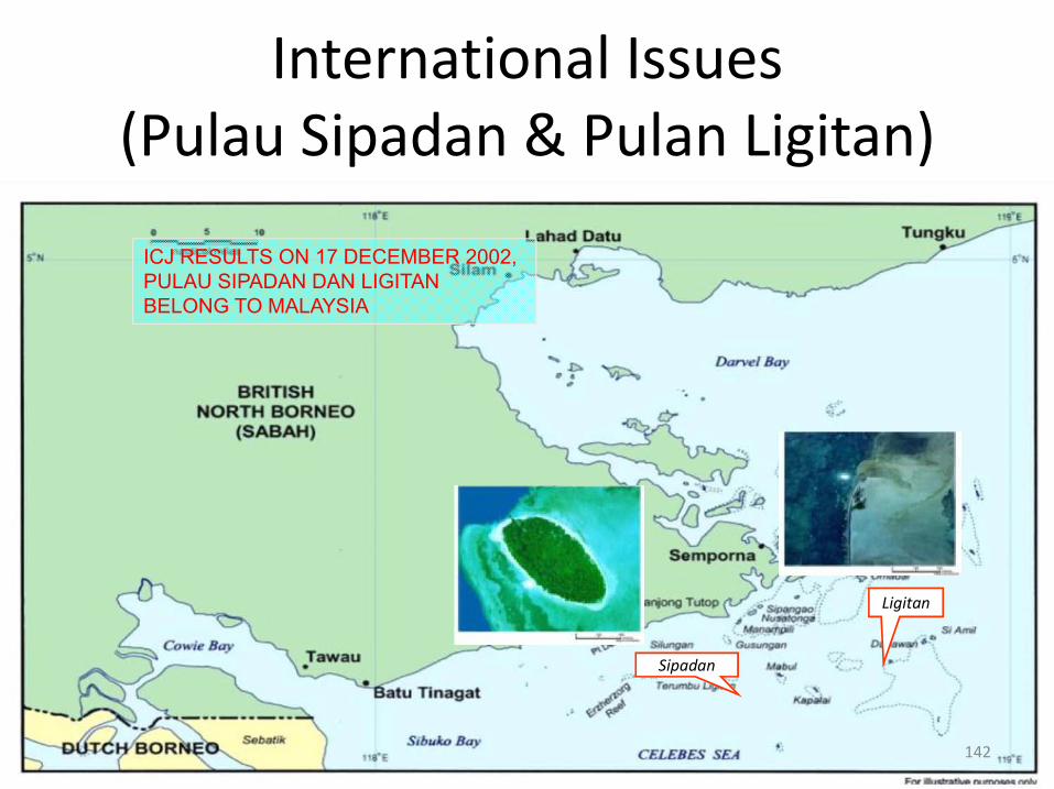
Sipadan
Ligitan
KEPUTUSAN ICJ PADA 17 DISEMBER 2002 TELAH MENETAPKAN PULAU SIPADAN DAN LIGITAN MILIK MALAYSIA.
112
Isu Antarabangsa (Pulau Sipadan & Pulan Ligitan)
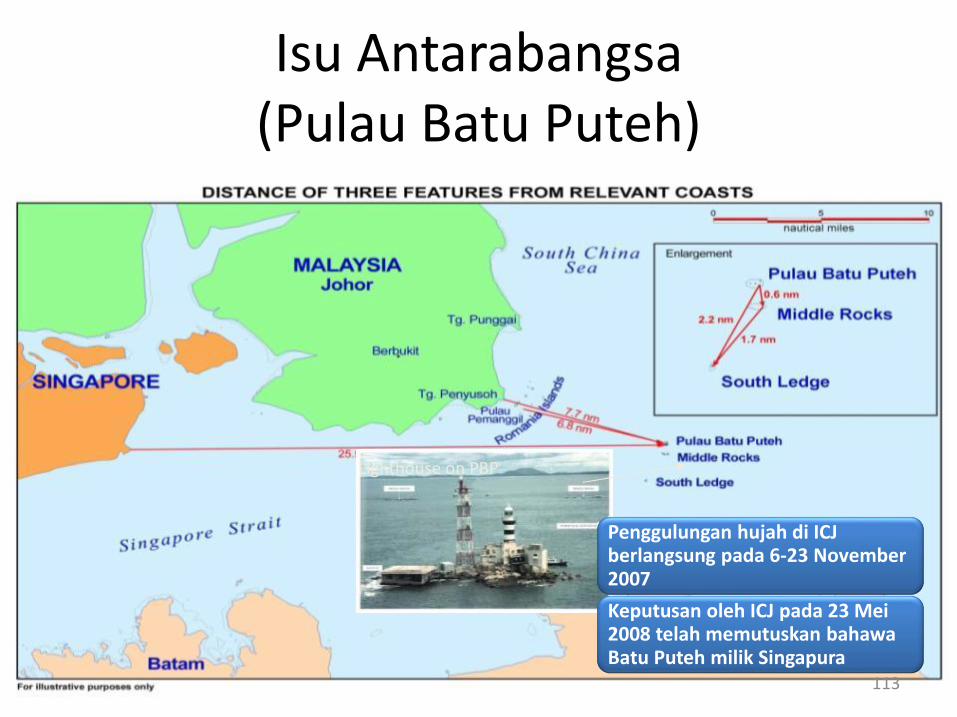
Lighthouse on PBP
Penggulungan hujah di ICJ berlangsung pada 6-23 November 2007
Keputusan oleh ICJ pada 23 Mei 2008 telah memutuskan bahawa Batu Puteh milik Singapura
113
Isu Antarabangsa (Pulau Batu Puteh)
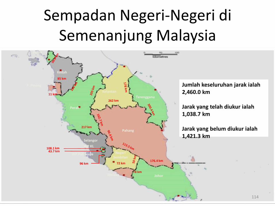
Pahang
Terengganu
Kelantan
Perak
Kedah
P. Pinang
Perlis
Selangor
WP KL
WP Putrajaya
JohorMelaka
NegeriSembilan
Jumlah keseluruhan jarak ialah 2,460.0 km
Jarak yang telah diukur ialah 1,038.7 km
Jarak yang belum diukur ialah 1,421.3 km
114
Sempadan Negeri-Negeri di Semenanjung Malaysia
RTK Net
JUPEM2U
115
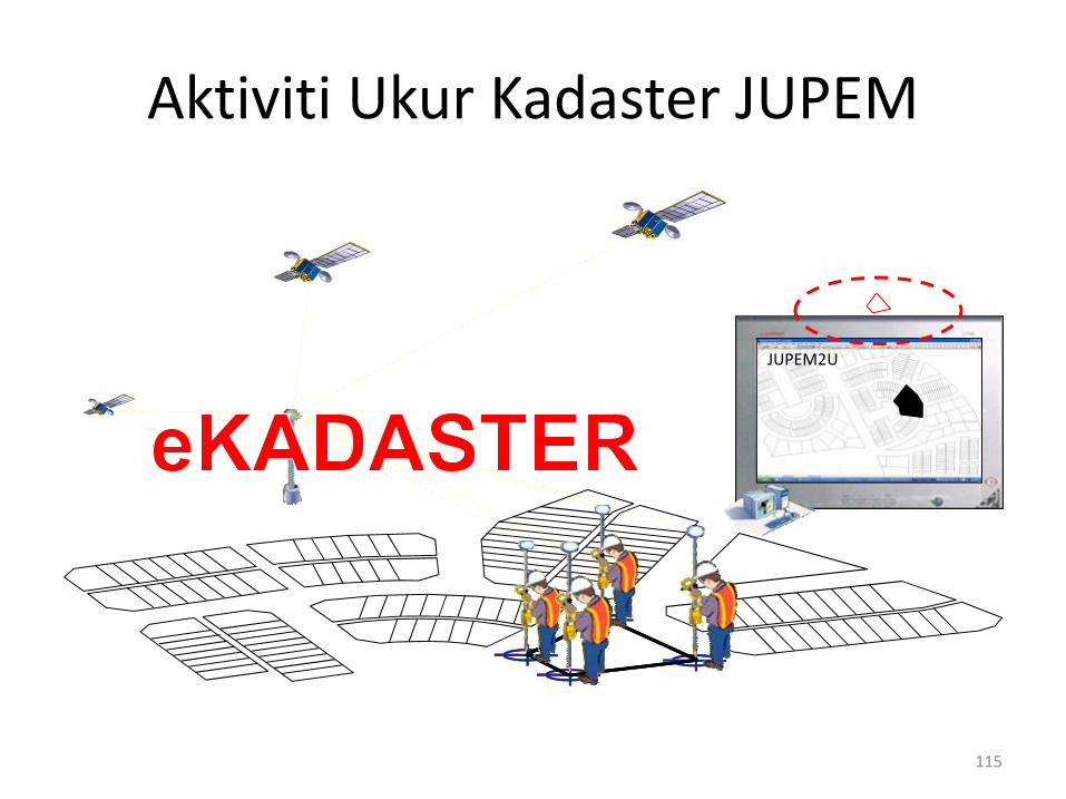
Aktiviti Ukur Kadaster JUPEM
Aktiviti Ukur Kadaster JUPEM
Penasihat jabatan berkaitan ukuran kadaster berdasarkan kepadaperuntukan peraturan dan undang-undang dan Pekeliling KetuaPengarah Ukur dan Pemetaan Malaysia (PKPUP)
Memastikan tugas yang diberikan kepada Jabatan Ukur DanPemetaan Malaysia Negeri dijalankan dan disiapkan mengikut masadan sasaran yang ditetapkan.
Memantau & memastikan kemajuan dan kualiti kerja-kerja ukurkadaster yang dijalankan oleh Juruukur tanah Berlesen mengikutperaturan yang ditetapkan. Semakan kerja-kerja Juruukur TanahBerlesen di lapangan secara rambang.
Memastikan perancangan berterusan sejajar dengan keperluanterhadap sistem penyampaian kepada stakeholders. 116
Aktiviti Ukur Kadaster JUPEM
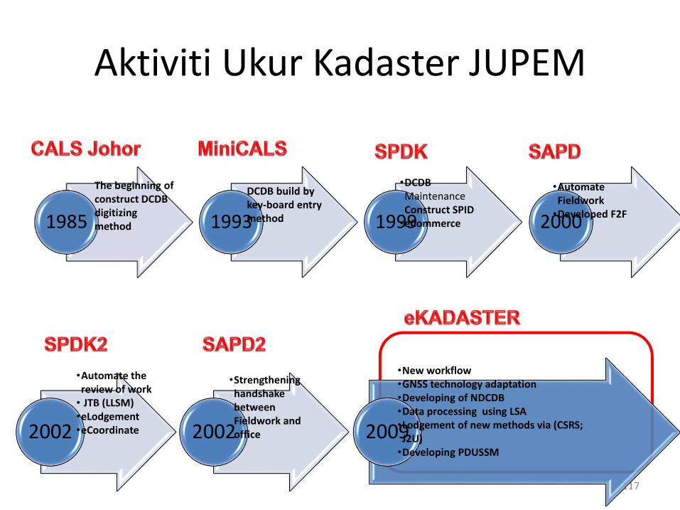
117
2002 2002 2009
•Automate the review of work
• JTB (LLSM)•eLodgement•eCoordinate
•Strengthening handshake between Fieldwork and office
•New workflow•GNSS technology adaptation•Developing of NDCDB•Data processing using LSA•Lodgement of new methods via (CSRS; J2U)
•Developing PDUSSM
1985 1993 1999 2000
The beginning of construct DCDB digitizing method
DCDB build by key-board entry method
•DCDB MaintenanceConstruct SPID
•eCommerce
•Automate Fieldwork
•Developed F2F
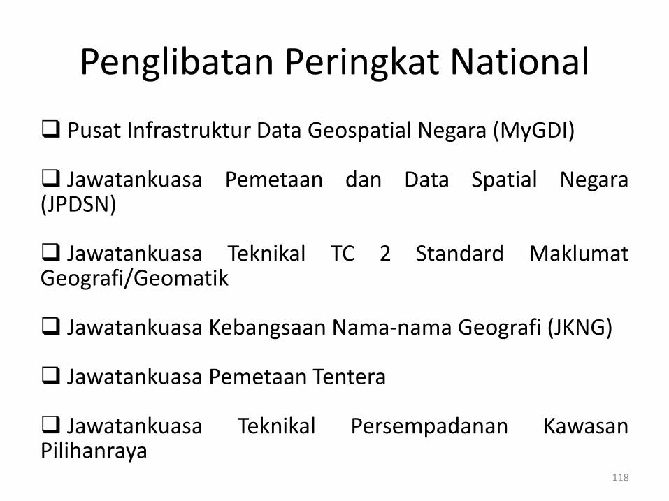
Penglibatan Peringkat National
Pusat Infrastruktur Data Geospatial Negara (MyGDI)
Jawatankuasa Pemetaan dan Data Spatial Negara(JPDSN)
Jawatankuasa Teknikal TC 2 Standard MaklumatGeografi/Geomatik
Jawatankuasa Kebangsaan Nama-nama Geografi (JKNG)
Jawatankuasa Pemetaan Tentera
Jawatankuasa Teknikal Persempadanan KawasanPilihanraya
118
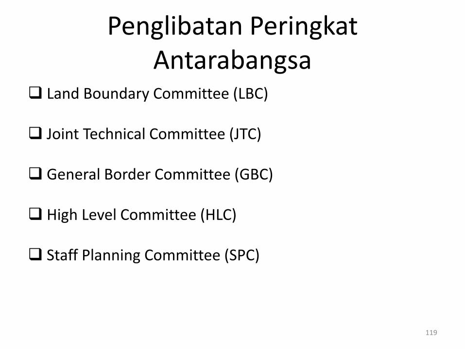
Penglibatan Peringkat Antarabangsa
Land Boundary Committee (LBC)
Joint Technical Committee (JTC)
General Border Committee (GBC)
High Level Committee (HLC)
Staff Planning Committee (SPC)
119
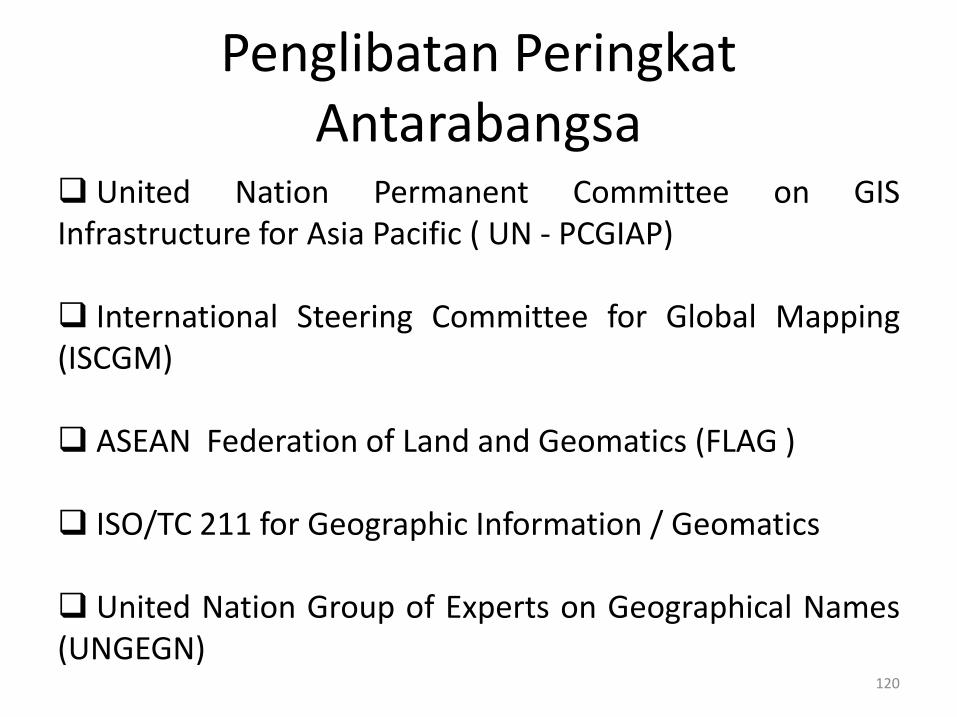
Penglibatan Peringkat Antarabangsa
United Nation Permanent Committee on GISInfrastructure for Asia Pacific ( UN - PCGIAP)
International Steering Committee for Global Mapping(ISCGM)
ASEAN Federation of Land and Geomatics (FLAG )
ISO/TC 211 for Geographic Information / Geomatics
United Nation Group of Experts on Geographical Names(UNGEGN)
120

121
Activities JUPEM
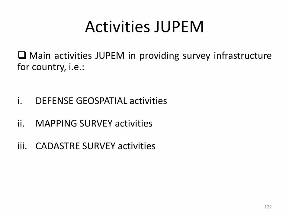
Activities JUPEM
Main activities JUPEM in providing survey infrastructurefor country, i.e.:
i. DEFENSE GEOSPATIAL activities
ii. MAPPING SURVEY activities
iii. CADASTRE SURVEY activities
122
ATM Command & Control System
Tentera Udara DiRaja Malaysia
TenteraDarat
Maklumat Geospatial Pertahanan
ASTROSSII
JERNAS
ARTHUR
PT 91M
Sukhoi SU-30MKM
Pesawat Hawk
Pesawat CN235BERSAMA
AGUSTA A109 LOH
123
Defense Geospatial Activities of JUPEM
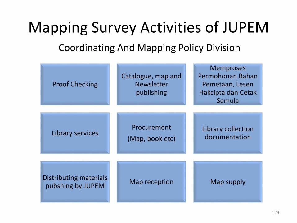
Coordinating And Mapping Policy Division
Proof CheckingCatalogue, map and
Newsletter publishing
Memproses Permohonan Bahan
Pemetaan, Lesen Hakcipta dan Cetak
Semula
Library servicesProcurement
(Map, book etc)
Library collection documentation
Distributing materials pubshing by JUPEM
Map reception Map supply
124
Mapping Survey Activities of JUPEM
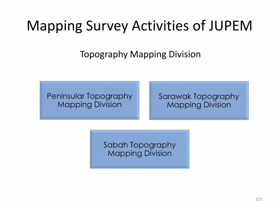
Topography Mapping Division
Peninsular Topography Mapping Division
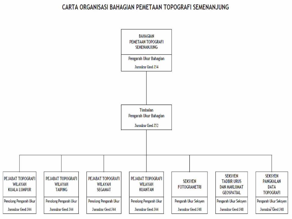
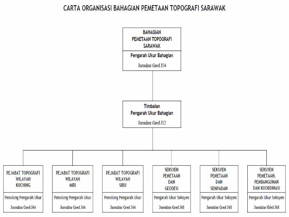
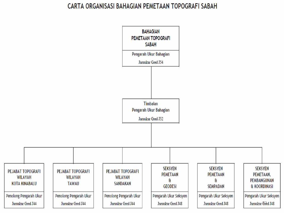
Sarawak Topography Mapping Division
Sabah Topography Mapping Division
125
Mapping Survey Activities of JUPEM
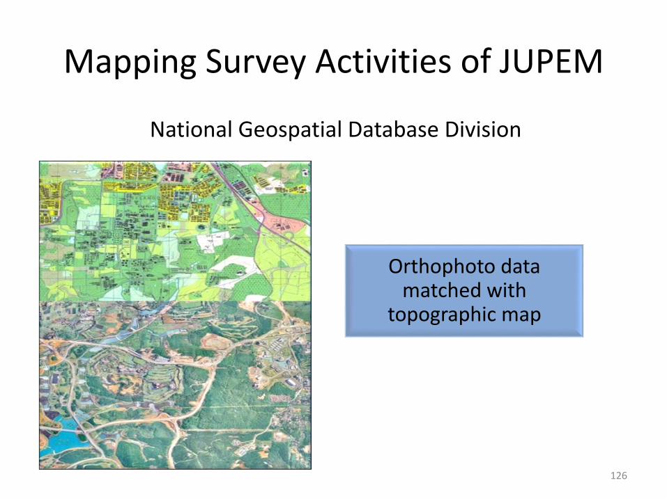
National Geospatial Database Division
Orthophoto data matched with
topographic map
126
Mapping Survey Activities of JUPEM
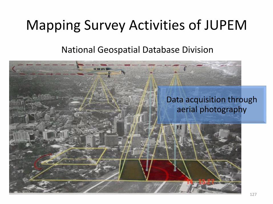
Data acquisition through aerial photography
127
National Geospatial Database Division
Mapping Survey Activities of JUPEM

Aerial photography
128
National Geospatial Database Division
Mapping Survey Activities of JUPEM
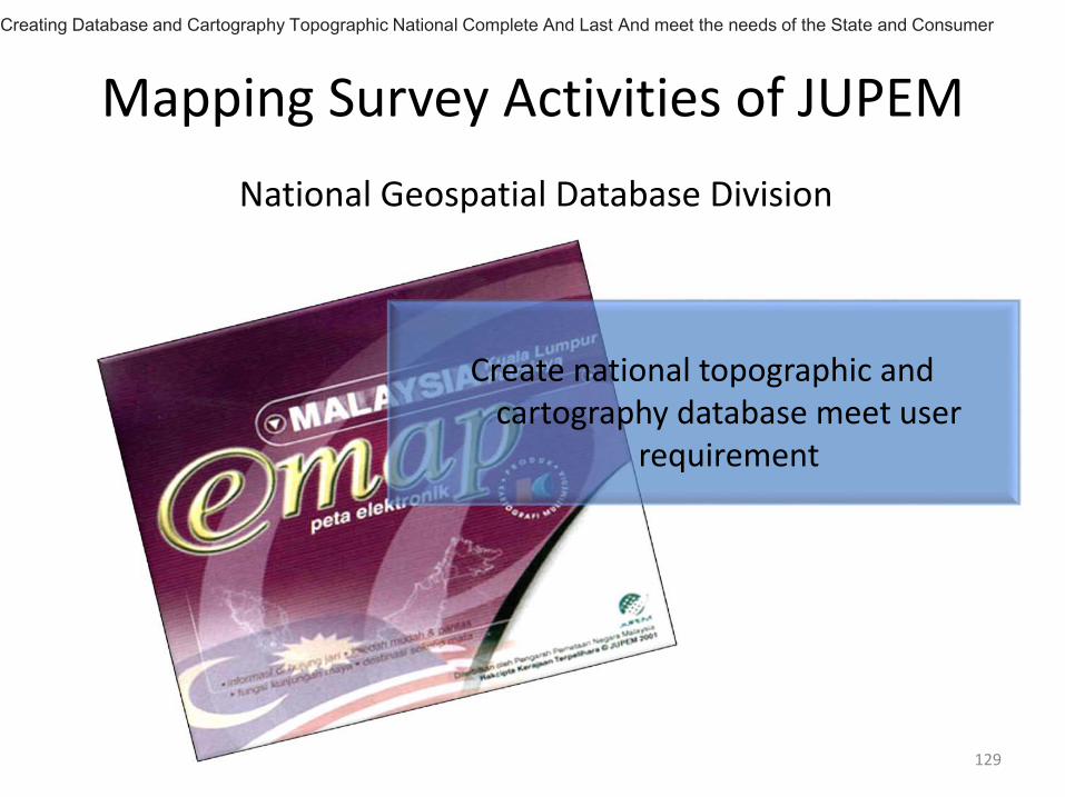
Create national topographic and cartography database meet user
requirement
129
National Geospatial Database Division
Mapping Survey Activities of JUPEM
Creating Database and Cartography Topographic National Complete And Last And meet the needs of the State and Consumer
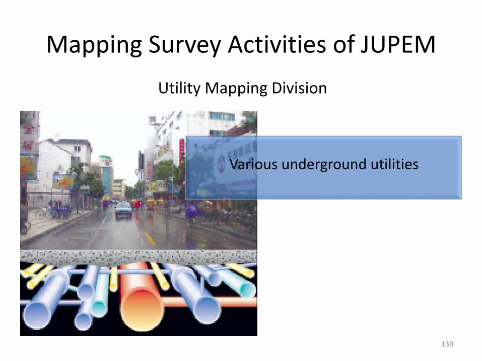
Various underground utilities
130
Utility Mapping Division
Mapping Survey Activities of JUPEM
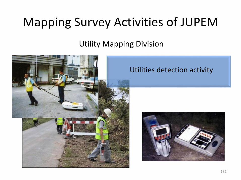
Utilities detection activity
131
Utility Mapping Division
Mapping Survey Activities of JUPEM
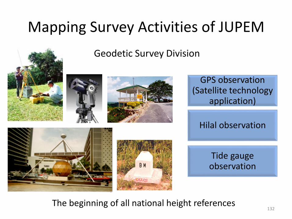
GPS observation (Satellite technology
application)
Hilal observation
Tide gauge observation
The beginning of all national height references132
Geodetic Survey Division
Mapping Survey Activities of JUPEM
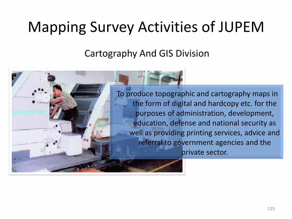
To produce topographic and cartography maps in the form of digital and hardcopy etc. for the purposes of administration, development,
education, defense and national security as well as providing printing services, advice and
referral to government agencies and the private sector.
133
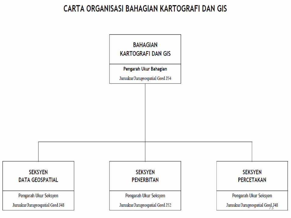
Cartography And GIS Division
Mapping Survey Activities of JUPEM
International Maritime Boundary
Land Boundary (State/International)
134
Boundary Affairs Division
Mapping Survey Activities of JUPEM
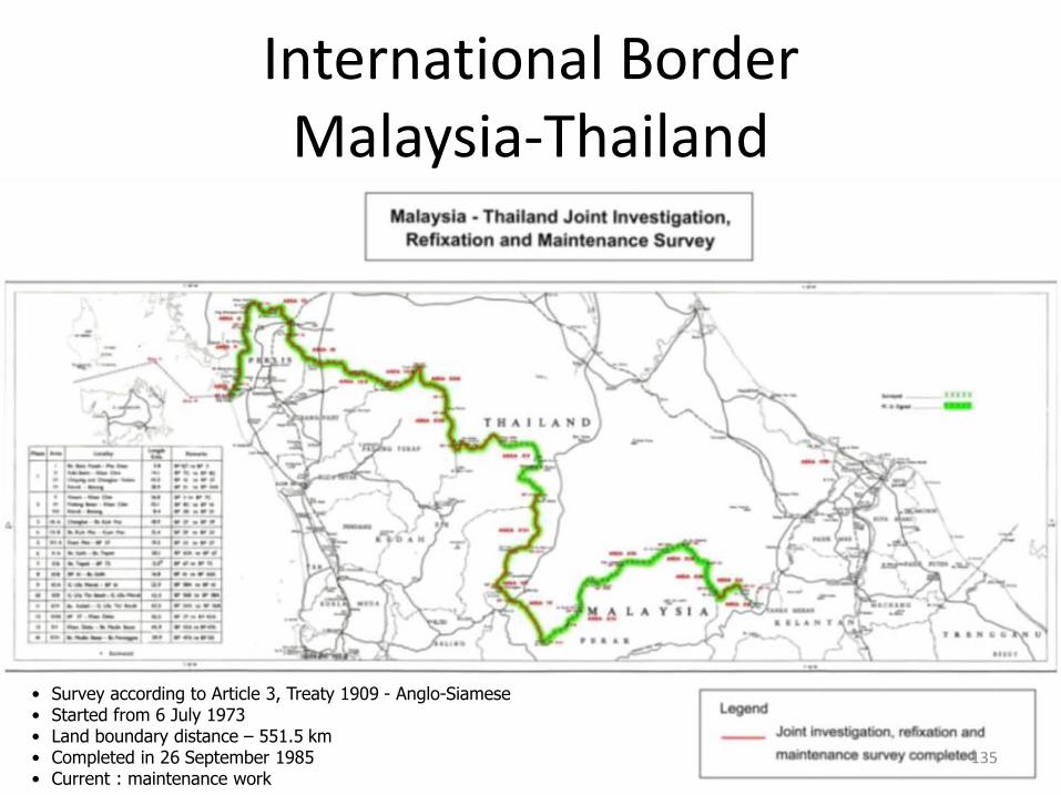
• Survey according to Article 3, Treaty 1909 - Anglo-Siamese• Started from 6 July 1973• Land boundary distance – 551.5 km• Completed in 26 September 1985• Current : maintenance work
135
International BorderMalaysia-Thailand
136
International BorderMalaysia-Indonisia
137
International BorderMalaysia-Brunei
138
International BorderMalaysia-Singapura
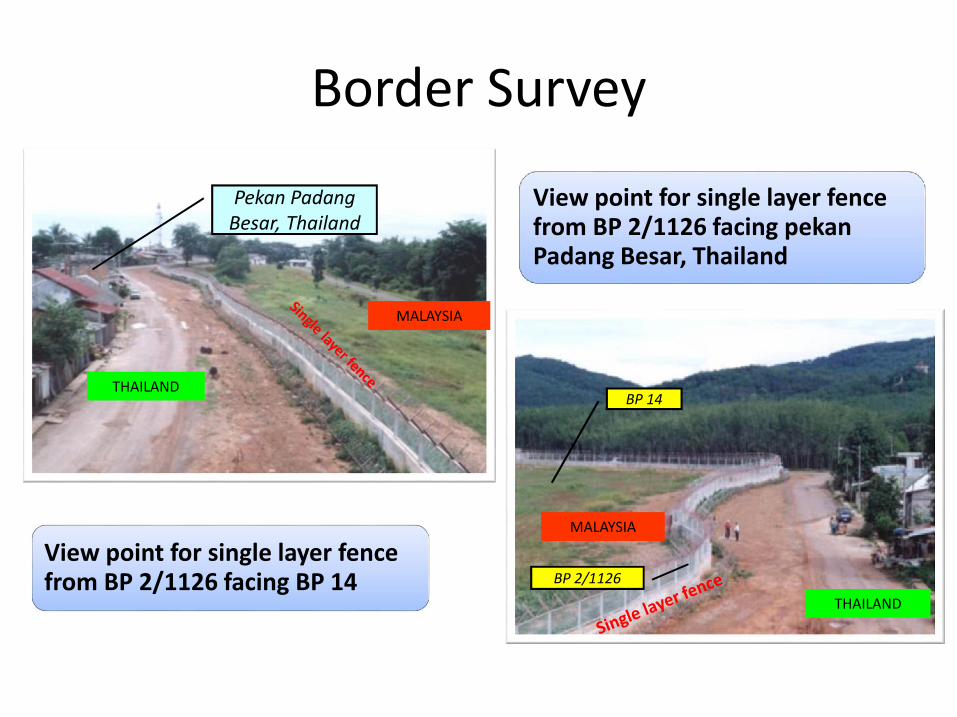
View point for single layer fence from BP 2/1126 facing pekan Padang Besar, Thailand
View point for single layer fence from BP 2/1126 facing BP 14
THAILAND
MALAYSIA
MALAYSIA
THAILAND
Pekan Padang Besar, Thailand
BP 2/1126
BP 14
Border Survey
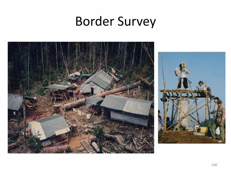
140
Border Survey
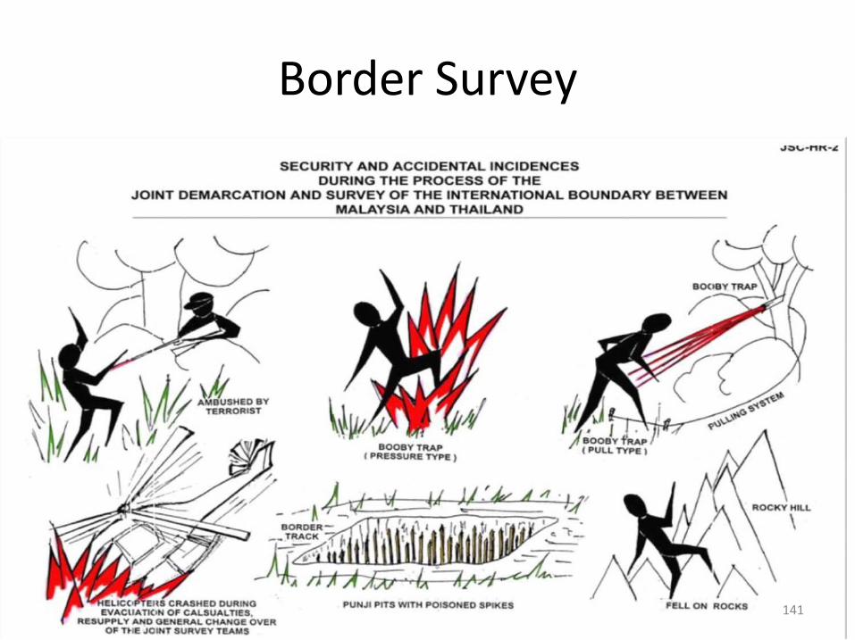
141
Border Survey
Sipadan
Ligitan
ICJ RESULTS ON 17 DECEMBER 2002, PULAU SIPADAN DAN LIGITAN BELONG TO MALAYSIA
142
International Issues(Pulau Sipadan & Pulan Ligitan)

Lighthouse on PBP
Penggulungan hujah di ICJ berlangsung pada 6-23 November 2007
Keputusan oleh ICJ pada 23 Mei 2008 telah memutuskan bahawa Batu Puteh milik Singapura
143
International Issues(Pulau Batu Puteh)
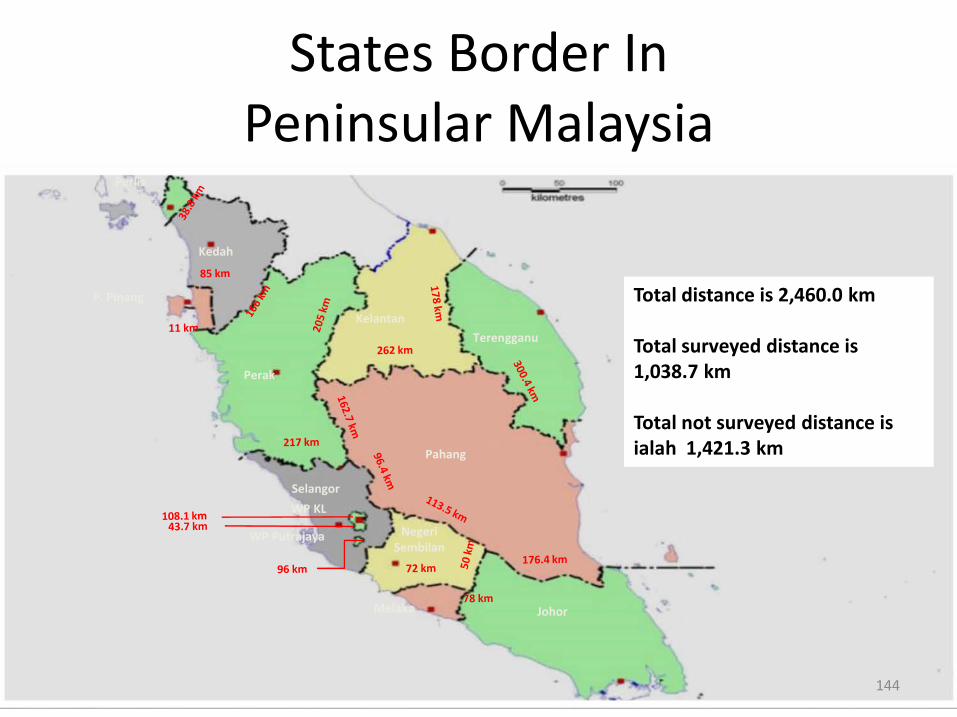
Pahang
Terengganu
Kelantan
Perak
Kedah
P. Pinang
Perlis
Selangor
WP KL
WP Putrajaya
JohorMelaka
NegeriSembilan
Total distance is 2,460.0 km
Total surveyed distance is 1,038.7 km
Total not surveyed distance is ialah 1,421.3 km
144
States Border In Peninsular Malaysia
RTK Net
JUPEM2U
145
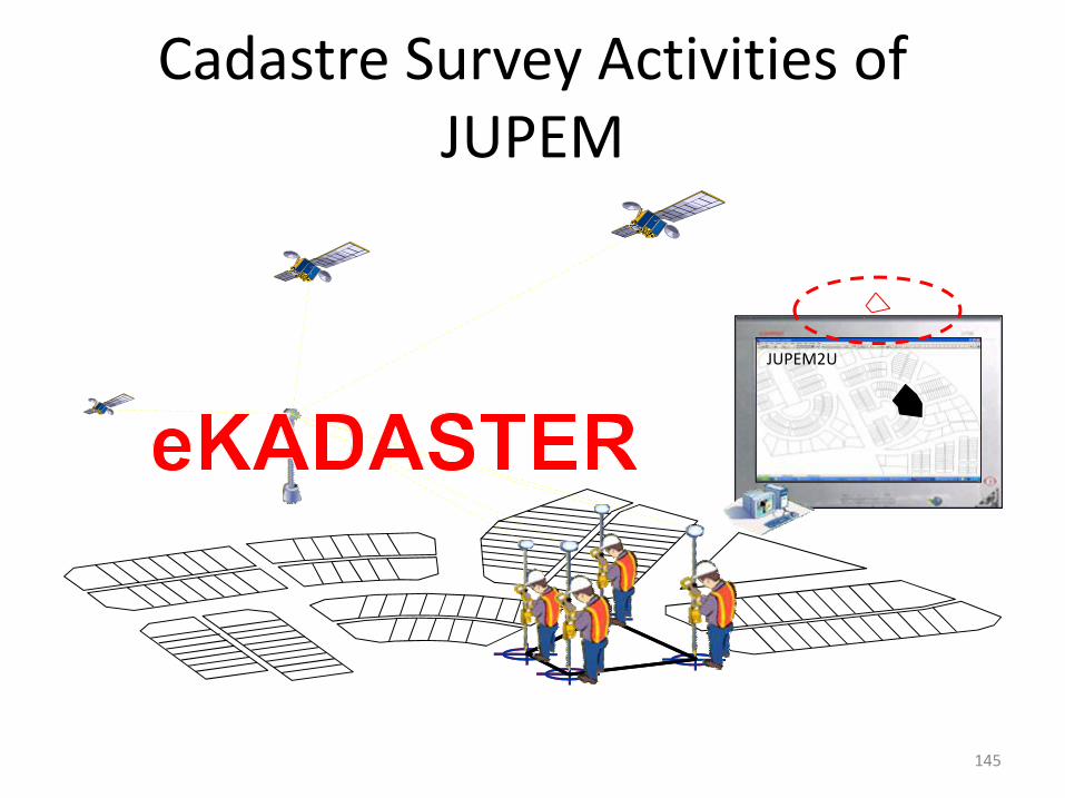
Cadastre Survey Activities of JUPEM
Cadastre Survey Activities of JUPEM
To advise DSMM on cadastre survey based on laws,regulations and Director General Circular.
To ensure tasks assigned to DSMM to be conducted andcompleted according to time and targets.
To monitor and ensure the progress and quality of cadastralsurvey work conducted by a Licensed Land Surveyor inaccordance with the regulations. Checking on the work done byLicensed Land Surveyor in the field at random.
To ensure continuously planning in line with the needs ofservices delivery to stakeholders.
146
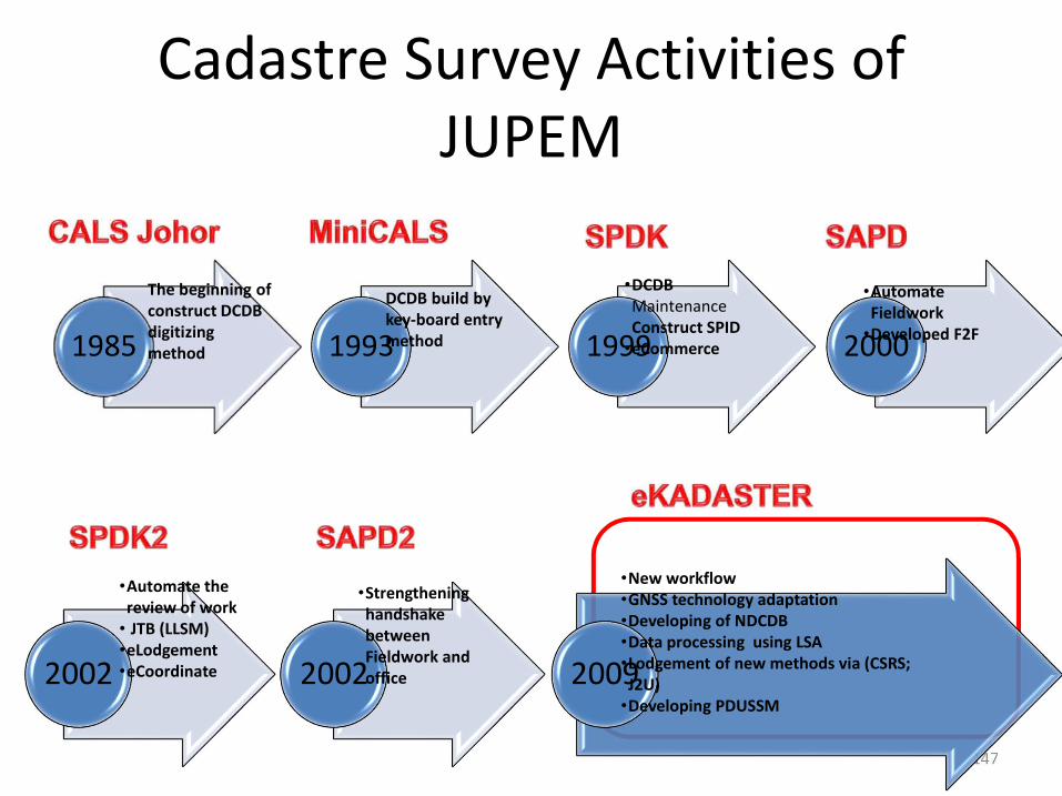
Cadastre Survey Activities of JUPEM
147
2002 2002 2009
•Automate the review of work
• JTB (LLSM)•eLodgement•eCoordinate
•Strengthening handshake between Fieldwork and office
•New workflow•GNSS technology adaptation•Developing of NDCDB•Data processing using LSA•Lodgement of new methods via (CSRS; J2U)
•Developing PDUSSM
1985 1993 1999 2000
The beginning of construct DCDB digitizing method
DCDB build by key-board entry method
•DCDB MaintenanceConstruct SPID
•eCommerce
•Automate Fieldwork
•Developed F2F
Involvement At National Level
Malaysia Geospatial Data Infrastructure (MyGDI)
National Mapping and Spatial Data Committee (JPDSN)
TC 2 Standard Geography / Geomatics TechnicalCommittee
National Geographical Name Committee (JKNG)
Defence Mapping Committee
Election Border Technical Committee
148

Involvement At International Level
Land Boundary Committee (LBC)
Joint Technical Committee (JTC)
General Border Committee (GBC)
High Level Committee (HLC)
Staff Planning Committee (SPC)
149
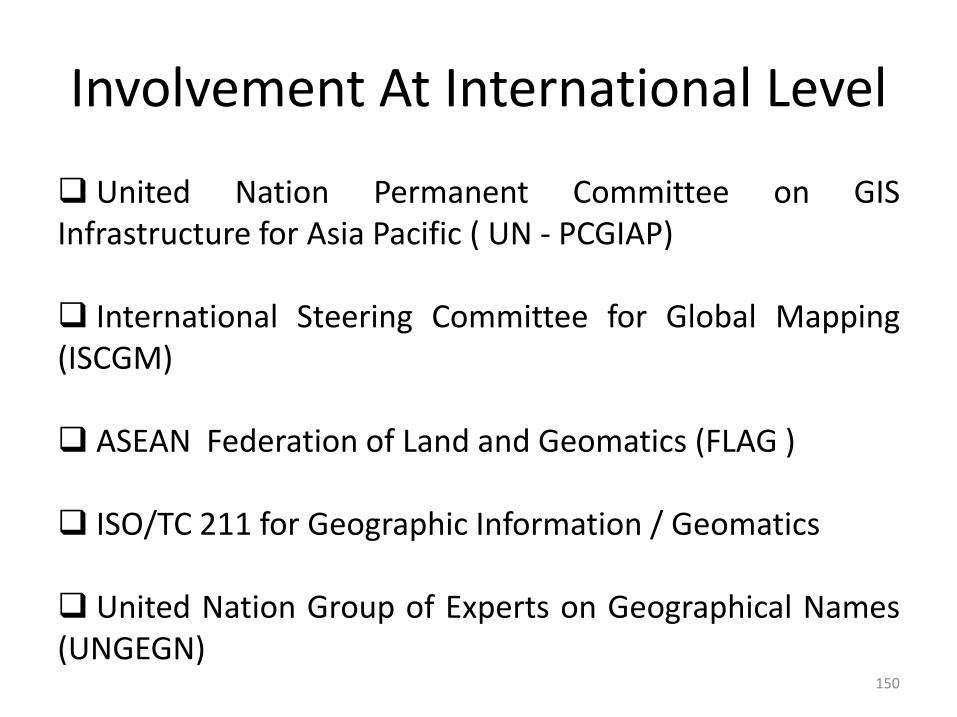
Involvement At International Level
United Nation Permanent Committee on GISInfrastructure for Asia Pacific ( UN - PCGIAP)
International Steering Committee for Global Mapping(ISCGM)
ASEAN Federation of Land and Geomatics (FLAG )
ISO/TC 211 for Geographic Information / Geomatics
United Nation Group of Experts on Geographical Names(UNGEGN)
150

LAND SURVEYORS BOARD OF PENINSULAR (LJT)
151

Land Surveyors Board
The Land Surveyors Board is a corporate body established on1st May 1958, under the Licensed Surveyors Act 1958 (Act 458).Its established is to control and regulate the licensed landsurveyors and other related matters.
The Land Surveyors Board plays an important role in keepingthe surveying profession abreast with the latest developmentand advancement survey in sciences.
To achieve this objective, the Board is actively in contact withprofessionals and academic institution, both locally andinternationally.
Prominent members of the profession are invited toparticipate in courses and seminars to upgrade the knowledge insurveying sciences and to promote exchange of ideas.
152

Land Surveyors Board
Objective
To regulate and control the licensing of land surveyorsand all matters pertaining to cadastral survey.
To provide leadership in the upholding and advancementof the survey and mapping profession.
153

Land Surveyors Board
Functions
To keep and maintain a register of land surveyors.
To conduct examinations for persons who desire toregister with the Board.
To approve or reject application for registration.
154

Land Surveyors Board
Functions
To establish a Training School for survey technicians.
To administer the collection and payment of survey fee.
To exercise disciplinary control in accordance with theprovisions of the Act
155
Land Surveyors Board
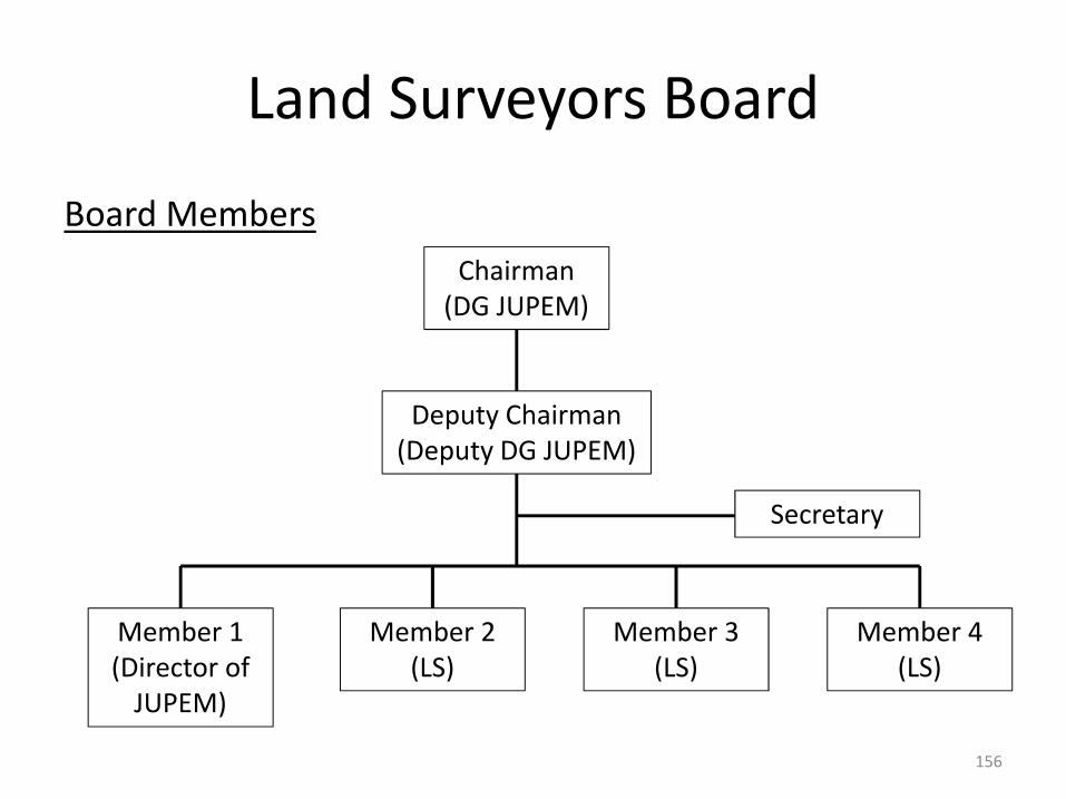
Board Members
156
Chairman(DG JUPEM)
Deputy Chairman(Deputy DG JUPEM)
Member 1(Director of
JUPEM)
Member 2(LS)
Member 3(LS)
Member 4(LS)
Secretary

ROYAL INSTITUTION OF SURVEYORS MALAYSIA (RISM)
157
History
The surveyors were first recognised as a professional in 1885with the setting up of the Survey Department.
Prior to March 1961, there were to professional bodiesrepresenting surveyors, The Malayan Institution of Surveyors(the former RICS Federation of Malaya Branch) and theInstitution of Land Surveyors.
History for surveyors was made on the 13 March 1961, whenthese two bodies met at the Boardroom of the Royal SelangorClub resolved to form then The Institution of Surveyors(Federation of Malayan).
158
History The meeting elected Mr. Khoo Soo Guan (President), Mr. W. G. Wicks(Vice-President), Mr. Yap Thean Ee (Honorary Secretary) and Mr. R. H.Norris (Honorary Treasurer) as the first Committee. On 2nd December1961, the Inaugural General Meeting was held at the Shell Theatrette inKuala Lumpur. About 38 fellows and members attended the meeting.
The First Council Meeting of the Institution was held on 14th December1961 at the Conference Room, Survey Department Head Quarters,Montbatten Road. At the E.G.M. held on 19th June 1966, the name of theInstitution was changed to the Institution of Surveyors Malaysia (ISM).
In the years 0f 2011, in the Extra Ordinary Annual General Meeting on19th June 2011, the Institution rename to the Royal Institution o SurveyorsMalaysia (RISM), where the DYMM Sultan Selangor as the Parton.
159
Division
Geomatic & Land Surveying (GLS)
Quantity Surveying (QS)
Property Management and Valuation Surveying (PMVS)
Building Surveying (BS)
160
Membership
Fellows (FRISM) and prefix Sr
Every Fellow shall be more than thirty-five years of age, shall haveacquired a practical knowledge of surveying in one or other of itsbranches and shall have had not less than five years professionalexperience after being elected as a member of the RISM.
No person shall be eligible for transfer to the Fellowship unless heshall have passed the examination or examination required for electionto that class under the Rules of Examination, or such otherexamination or examination accepted by the Council.
Every Fellow shall be eligible for election to the Council, for electionor appointment to all officers of the RISM, and shall be entitled to allits rights and privileges.
161

Membership
Members (MRISM) and prefix Sr
Every Member shall be more than twenty-one years of age and shallhave acquired a practice knowledge of surveying in one or other of itsbranches.
No person shall be eligible as Member who shall not have passedthe examinations required for election to that class under the Rules ofExamination, or such other examination or examinations accepted bythe Council.
Members shall not be eligible foe the office of President or DeputyPresident but subject to the By-Laws and regulation of the Council,shall be eligible for election or appointment to other offices of theRISM, and shall be entitled to all its rights and privileges.
162

Membership
Associates
Any person from time to time who is not a surveyor byprofession but one who, be reason of his pursuits, has madea significant contribution to the advancement of knowledgein the surveying profession shall be eligible for election asan Associate.
Associates shall be entitled to all rights and privileges ofthe RISM except that they shall not be eligible to hold anyoffice of the RISM nor have rights of voting.
163
Membership
Honorary Fellows
Every Honorary shall be a person who by reason either of hisposition or experience, or of his eminence in science, may beenabled to render assistance in promoting the objects of theRISM but who is not engaged in practice as a surveyor inMalaysia.
Any Honorary Fellow shall not be entitled to be present ortake part in any Extraordinary General Meeting but he shall havethe privilege of being present at and taking in all Annual andOrdinary General Meetings and access to the Library. He shallhave no right of voting, discussing, or otherwise intervening inthe affairs of the RISM nor shall be called upon to contribute toits funds.
164

Membership
Graduate Members
Graduate Members shall be persons who have passed theFinal Examination or such other examination, if any, as maybe accepted by the Council and who have yet to acquire apractical knowledge in surveying in one or other of itsbranches.
165
Membership
Probationers Members
Probationers Members shall be persons who have passedthe intermediate examination, or such other examination, ifany, as may be accepted by the Council and such a personmay continue as a Probationers until the end of the fifthcalendar year after that in which he has passed suchexamination, provided always that the Council shall havepower to vary the period of probation either generally or inthe case of particular persons.
166

Membership
Students Members
Students Members shall be persons not under seventeen yearsof age who are or have been undergoing suitable practicetraining and instruction approved by the Council as pupils orassistants or who are studying with a view to entering theprofession at such places of professional instruction as theCouncil may approve; and such persons may continue asStudents until they passed the intermediate examination or suchother examination, if any, as may be accepted by the Council oruntil the end of the fifth calendar year from the date upon whichthey shall have been enrolled into the class whichever happensfirst; provided always that the Council shall have power to varythe period of studentship either generally or in the case ofparticular persons.
167
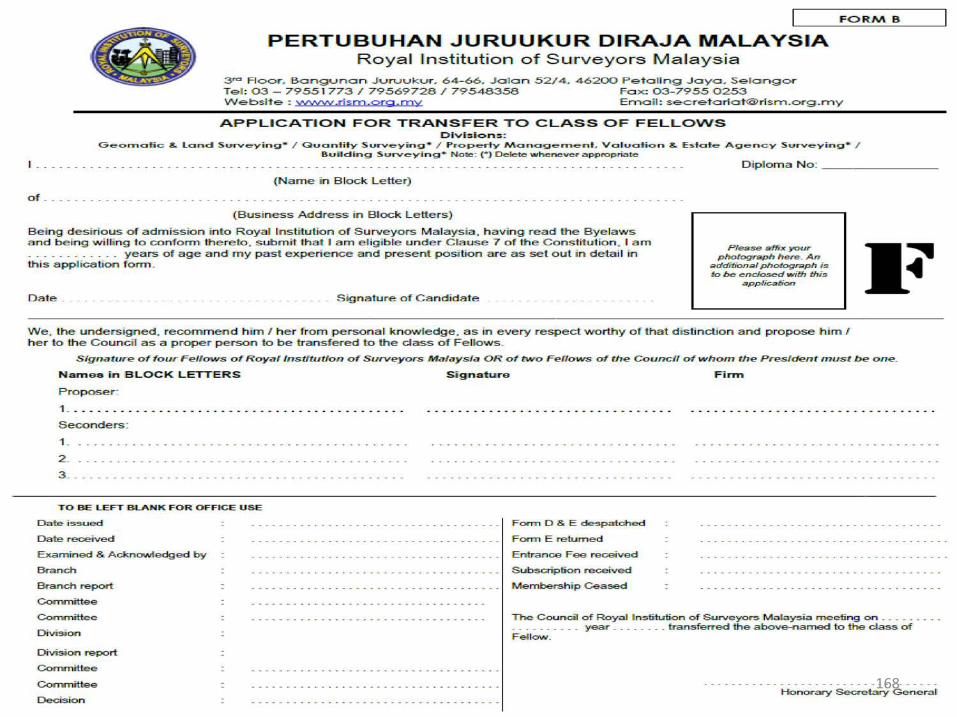
168
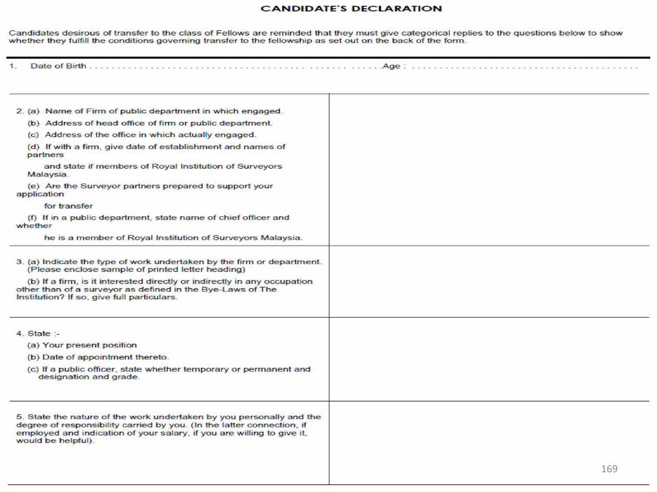
169

170

171
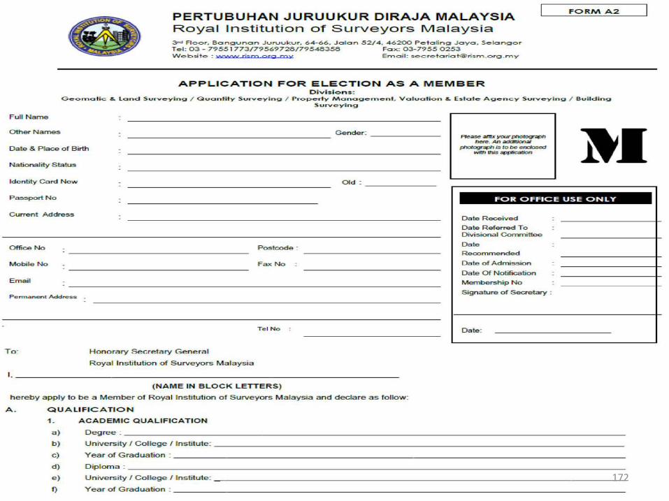
172

173
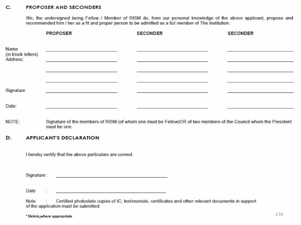
174
175

176
177
178

179
180

T H A N K YO U
181