Embed Size (px)
Citation preview
Coastal hazard risk management and adaptation planning guidelines
CONTENTS
Coastal zones are vulnerable to adverse impacts from inundation and erosion. The risk to the environment from climate change is influenced by the level of preparedness and response of the community and its recovery capacity.
Page 2 Coastal hazard risk management and adaptation planning guidelines
PAR
T 1
– O
VE
RV
IEW
Coastal zones are vulnerable to adverse impacts from inundation and erosion. The risk to the environment from climate change is influenced by the level of preparedness and response of the community and its recovery capacity.
Disclaimer
This document has been published by the Western Australian Planning Commission. Any representation, statement, opinion or advice expressed or implied in this publication is made in good faith and on the basis that the Government, its employees and agents are not liable for any damage or loss whatsoever which may occur as a result of action taken or not taken, as the case may be, in respect of any representation, statement, opinion or advice referred to herein. Professional advice should be obtained before applying the information contained in this document to particular circumstances.
CONTENTS
PART 1 – OVERVIEW 31. INTRODUCTION 3
1.1. Purpose 41.2. Risk management and adaptation planning 41.3. Targeted hazards 71.4. Definitions/terminology 7
PART 2 – GUIDELINES 81. ESTABLISHING THE CONTEXT 8
1.1. Purpose 81.2. Objectives 91.3. Scope 91.4. Study area 101.5. Community and stakeholders consultation 11 1.5.1. Internal engagement 121.6. Existing planning controls 121.7. Key elements (Assets) 131.8. Success criteria 14
2. IDENTIFY 152.1. Vulnerability assessment 172.2. Planning timeframe/climate change scenarios 172.3. Structures 182.4. Exposure 192.5. Sensitivity 192.6. Potential impacts 192.7. Adaptive capacity 202.8. Coastal hazard mapping 20
3. ANALYSE 213.1. Likelihood 213.2. Consequence 22
4. EVALUATE 254.1. Risk scale 254.2. Existing controls 27
5. RISK MANAGEMENT AND ADAPTATION 285.1. Risk management and adaptation hierarchy 285.2. Risk management and adaptation options 295.3. Comparative evaluation of risk management and adaptation options (cost benefit analysis
and multi-criteria analysis) 335.4. Recommended risk level and management
and adaptation options 345.5. Implementation plan 34
6. MONITORING AND REVIEW 35
7. COMMUNICATION OF RESULTS 36
PART 3 – REFERENCES 37
© Western Australian Planning Commission
Published by theWestern Australian Planning CommissionGordon Stephenson House140 William StreetPerth WA 6000
Locked Bag 2506
Perth WA 6001
Published September 2014
website: www.planning.wa.gov.auemail: [email protected]
tel: 08 6551 9000 fax: 08 6551 9001National Relay Service: 13 36 77infoline: 1800 626 477
This document is available in alternative formats on application to Communication Services.
Page 2
Page 3 Coastal hazard risk management and adaptation planning guidelines
PAR
T 1
– O
VE
RV
IEW
Coastal zones are vulnerable to adverse impacts from inundation and erosion. The risk to the environment from climate change is influenced by the level of preparedness and response of the community and its recovery capacity.
1. INTRODUCTIONThe vulnerability of land use and development within the Western Australian coastal zone to physical process hazards is expected to increase in the future.
Coastal zones are vulnerable to adverse impacts from inundation and erosion. The risk to the environment from climate change is influenced by the level of preparedness and response of the community and its recovery capacity.
While the scientific community has established that human-induced climate change is occurring, uncertainty remains about the magnitude and extent of the impacts from these changes. Despite the uncertainty, early consideration of coastal hazards and the adaptation and management of appropriate planning responses can provide economic, environmental and social benefits.
National and international coastal planning practices are increasingly adopting a risk management approach to deal with the potential adverse impacts of coastal hazards. This ensures that coastal hazards are appropriately factored into decision-making processes for sustainable land use and development in the coastal zone. The State Government’s coastal planning policy State Coastal Planning Policy No. 2.6 State Coastal Planning Policy (SPP2.6) supports a risk management approach and provides the framework for undertaking risk management and adaptation planning for coastal hazards in Western Australia. The SPP2.6 Guidelines published 30 July 2013 section 4 provides a brief introduction to coastal hazard risk management and adaptation planning (CHRMAP). These guidelines provide more detail on CHRMAP and should be read in conjunction with SPP2.6 and its guidelines.
This publication is designed to assist statutory decision-makers (e.g. local governments, State government agencies, the Western Australian Planning Commission and the State Administrative Tribunal) to:
a. consider coastal hazards and to evaluate their likelihood and the consequence for specific assets;
b. identify realistic and effective management and adaptation responses to those risks; and
c. prioritise the management and adaptation responses.
Page 4 Coastal hazard risk management and adaptation planning guidelines
PAR
T 1
– O
VE
RV
IEW
Coastal zones are vulnerable to adverse impacts from inundation and erosion. The risk to the environment from climate change is influenced by the level of preparedness and response of the community and its recovery capacity.
1.1. Purpose
These guidelines have been produced to support the implementation of SPP2.6 by assisting decision-makers in developing and implementing effective CHRMAP. They provide an overview and explanation of:
• the process for undertaking CHRMAP;
• determining appropriate content for CHRMAP; and
• assessing options for appropriate management and adaptation to risk.
1.2. Risk management and adaptation planning
Coastal hazard risk management and adaptation planning should be an integral part of decision-making, as it provides a robust method for addressing uncertainty associated with coastal hazard impacts and timeframes. Given there is a direct relationship between risk and opportunity in all decision making, decision-makers need to identify, measure and manage coastal hazard risk to ensure they appropriately capitalise on those opportunities and achieve their goals and objectives.
Risk is defined as a hazardous event or circumstance and the consequences that may flow from it. Risk is measured in terms of a combination of the likelihood of a hazard occurring and the consequence of that hazard occurring.
Put simply, risk management and adaptation planning is the practice of systematically identifying and understanding coastal hazard risks and putting in place controls to manage them in association with the affected community and stakeholders.
Throughout Australia AS/NZS ISO 31000:2009 is commonly used in coastal planning risk management. This standard provides a set of internationally endorsed principles and guidance on how decision-makers can integrate decisions about risk and responses into their existing management and decision-making processes. In 2013, Standards Australia published AS 5334:2013 Climate change adaptation for settlements and infrastructure – A risk based approach, which has been adapted from ISO 31000:2009 to specifically deal with the impact of climate change on settlements and infrastructure.
The process outlined in SPP2.6 follows a standardised approach (Figure 1) adapted from the risk management and vulnerability assessment process/es identified in Australian Standard: Risk management – Principles and guidelines (2009) (Figure 2), Australian Standard: Climate change adaptation for settlement and infrastructure – A risk based approach (2013), Australian Standard Environmental risk management – Principles and Processes (2006), Climate Change Impacts & Risk Management: A Guide for Business and Government (2007), and Climate Change Risk and Vulnerability: Promoting an efficient adaptation response in Australia, Report to the Australian Greenhouse Office (2005).
Page 5 Coastal hazard risk management and adaptation planning guidelines
PAR
T 1
– O
VE
RV
IEW
Coastal zones are vulnerable to adverse impacts from inundation and erosion. The risk to the environment from climate change is influenced by the level of preparedness and response of the community and its recovery capacity.
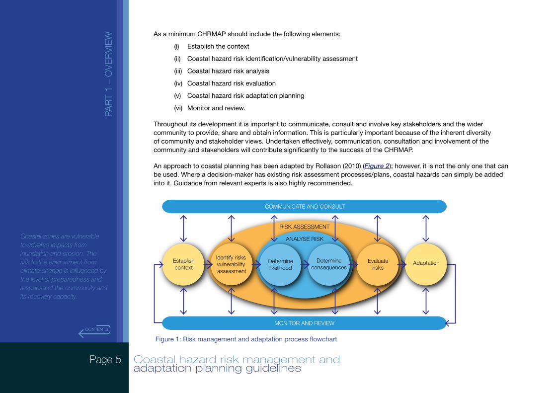
As a minimum CHRMAP should include the following elements:
(i) Establish the context
(ii) Coastal hazard risk identification/vulnerability assessment
(iii) Coastal hazard risk analysis
(iv) Coastal hazard risk evaluation
(v) Coastal hazard risk adaptation planning
(vi) Monitor and review.
Throughout its development it is important to communicate, consult and involve key stakeholders and the wider community to provide, share and obtain information. This is particularly important because of the inherent diversity of community and stakeholder views. Undertaken effectively, communication, consultation and involvement of the community and stakeholders will contribute significantly to the success of the CHRMAP.
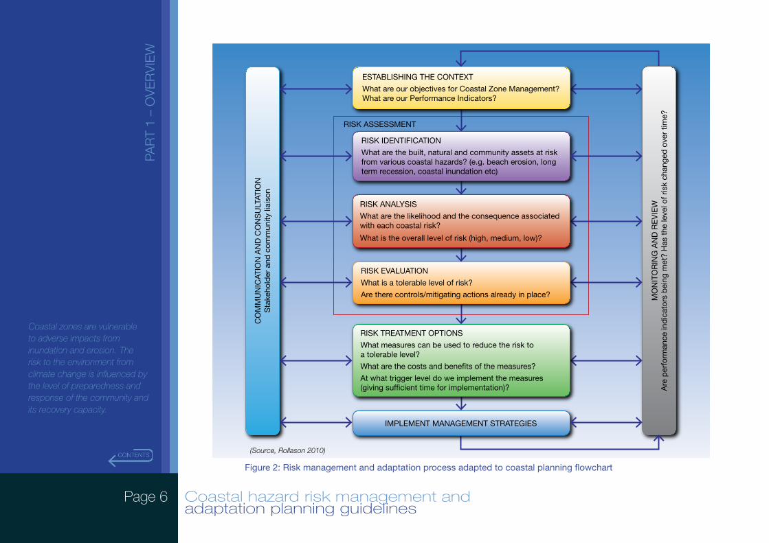
An approach to coastal planning has been adapted by Rollason (2010) (Figure 2); however, it is not the only one that can be used. Where a decision-maker has existing risk assessment processes/plans, coastal hazards can simply be added into it. Guidance from relevant experts is also highly recommended.
Figure 1: Risk management and adaptation process flowchart
RISK ASSESSMENT
ANALYSE RISK
Establishcontext
Identify risks vulnerability assessment
Determineconsequences
Determinelikelihood
Evaluaterisks
COMMUNICATE AND CONSULT
MONITOR AND REVIEW
Adaptation
Page 6 Coastal hazard risk management and adaptation planning guidelines
PAR
T 1
– O
VE
RV
IEW
Coastal zones are vulnerable to adverse impacts from inundation and erosion. The risk to the environment from climate change is influenced by the level of preparedness and response of the community and its recovery capacity.
MO
NIT
OR
ING
AN
D R
EV
IEW
Are
per
form
ance
ind
icat
ors
bei
ng m
et?
Has
the
leve
l of r
isk
chan
ged
ove
r tim
e?
IMPLEMENT MANAGEMENT STRATEGIES
CO
MM
UN
ICAT
ION
AN
D C
ON
SU
LTAT
ION
Sta
keho
lder
and
com
mun
ity li
aiso
n
RISK ASSESSMENT
RISK IDENTIFICATION
What are the built, natural and community assets at risk from various coastal hazards? (e.g. beach erosion, long term recession, coastal inundation etc)
ESTABLISHING THE CONTEXT
What are our objectives for Coastal Zone Management?What are our Performance Indicators?
RISK ANALYSIS
What are the likelihood and the consequence associated with each coastal risk?
What is the overall level of risk (high, medium, low)?
RISK EVALUATION
What is a tolerable level of risk?
Are there controls/mitigating actions already in place?
RISK TREATMENT OPTIONS
What measures can be used to reduce the risk to a tolerable level?
What are the costs and bene�ts of the measures?
At what trigger level do we implement the measures (giving suf�cient time for implementation)?
Figure 2: Risk management and adaptation process adapted to coastal planning flowchart
(Source, Rollason 2010)
Page 7 Coastal hazard risk management and adaptation planning guidelines
PAR
T 1
– O
VE
RV
IEW
Coastal zones are vulnerable to adverse impacts from inundation and erosion. The risk to the environment from climate change is influenced by the level of preparedness and response of the community and its recovery capacity.
1.3. Coastal hazards
Erosion and inundation are two primary coastal hazards targeted by these Guidelines, especially in areas where they are exacerbated due to the impacts of climate change and sea-level rise.
Consideration of these coastal processes should be based on the coastal type and each of the factors listed for that coastal type and assessment methodology as outlined in Schedule One of SPP2.6.
1.4. Definitions/terminology
All definitions for terminology used in these Guidelines have the same meaning as in SPP2.6. The following additional term is used:
Assets
Something that has potential or actual value to an organisation.
Notes:
1. Value can be tangible or intangible, financial or non-financial; examples of assets include financial assets, human resource assets, physical assets, and organization reputation.
2. Value includes consideration of risks and liabilities, and can be positive or negative at different stages of the asset’s life.
3. For most organizations, physical assets usually refer to equipment, inventory and properties owned by the organization. Physical assets are the opposite of intangible assets, which are non-physical assets such as leases, brands, intellectual property rights, reputation or agreements.
(AS 5334-2013, Pg. 13)
Page 8 Coastal hazard risk management and adaptation planning guidelines
PAR
T 2
– G
UID
ELI
NE
S
Protect, conserve and enhance coastal zone values, particularly in areas of landscape, biodiversity and ecosystem integrity, indigenous and cultural significance.
1. ESTABLISHING THE CONTEXTEstablishing the context for a coastal hazard risk management and adaptation planning review is about outlining the framework for identifying and analysing the coastal hazard risks being considered in the process. It enables stakeholders to start from a common understanding of the scope of the exercise, how risks are rated and how to approach the analysis.
Establishing the context assists in identifying and assessing adaptation options later in the process. This step is also important for clearly outlining what the coastal hazard risk management and adaptation planning is to encompass and what it is to exclude.
1.1. Purpose
The purpose of a CHRMAP review is to articulate the coastal hazards that have triggered the CHRMAP, which may include:
a. direction from previous local or government studies or policies that recommend the CHRMAP as a coastal planning method to deal with uncertainty;
b. the scale and extent of the existing or proposed land use and development assets area or values currently or potentially at risk; and
c. the flow-on effects to the social, environmental and economic elements of a specific decision-maker’s area of responsibility.
Box 1: Example of purpose
The coastal hazard risk management and adaptation planning (CHRMAP) is being prepared to provide strategic guidance on coordinated, integrated and sustainable management and adaptation for land use and development in the coastal zone likely to be affected by coastal hazards. It will establish the basis for present and future risk management and adaptation.
The locality is expected to experience significant population growth and the town is identified to become a regional centre. The coastal foreshore reserves are a major focus for recreation and are much of the basis for tourism in the region. Given the high importance of the coastal foreshore reserves to the permanent and tourist populations, supporting local businesses both directly and indirectly, it is of significant importance to preserve the coastal foreshore reserves.
Land use and development in areas A, B, D and F have in the past experienced erosion events, while areas C and E suffer ongoing recession. Interruption of natural sediment transport also occurs in these localities as artificial structures have been imposed in an attempt to ameliorate the impacts. In the past, previous management plans have been completed and this CHRMAP is intended to update and provide for a consistent management and adaptation plan across a specified area, focussed on the areas at greatest risk from coastal hazards.
Page 9 Coastal hazard risk management and adaptation planning guidelines
PAR
T 2
– G
UID
ELI
NE
S
Protect, conserve and enhance coastal zone values, particularly in areas of landscape, biodiversity and ecosystem integrity, indigenous and cultural significance.
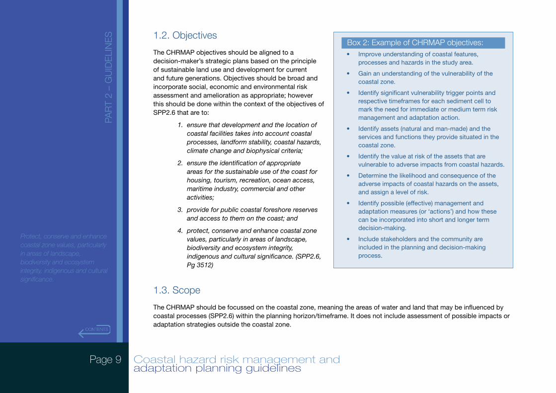
1.2. Objectives
The CHRMAP objectives should be aligned to a decision-maker’s strategic plans based on the principle of sustainable land use and development for current and future generations. Objectives should be broad and incorporate social, economic and environmental risk assessment and amelioration as appropriate; however this should be done within the context of the objectives of SPP2.6 that are to:
1. ensure that development and the location of coastal facilities takes into account coastal processes, landform stability, coastal hazards, climate change and biophysical criteria;
2. ensure the identification of appropriate areas for the sustainable use of the coast for housing, tourism, recreation, ocean access, maritime industry, commercial and other activities;
3. provide for public coastal foreshore reserves and access to them on the coast; and
4. protect, conserve and enhance coastal zone values, particularly in areas of landscape, biodiversity and ecosystem integrity, indigenous and cultural significance. (SPP2.6, Pg 3512)
1.3. Scope
The CHRMAP should be focussed on the coastal zone, meaning the areas of water and land that may be influenced by coastal processes (SPP2.6) within the planning horizon/timeframe. It does not include assessment of possible impacts or adaptation strategies outside the coastal zone.
Box 2: Example of CHRMAP objectives: • Improve understanding of coastal features,
processes and hazards in the study area.
• Gain an understanding of the vulnerability of the coastal zone.
• Identify significant vulnerability trigger points and respective timeframes for each sediment cell to mark the need for immediate or medium term risk management and adaptation action.
• Identify assets (natural and man-made) and the services and functions they provide situated in the coastal zone.
• Identify the value at risk of the assets that are vulnerable to adverse impacts from coastal hazards.
• Determine the likelihood and consequence of the adverse impacts of coastal hazards on the assets, and assign a level of risk.
• Identify possible (effective) management and adaptation measures (or ‘actions’) and how these can be incorporated into short and longer term decision-making.
• Include stakeholders and the community are included in the planning and decision-making process.
Page 10 Coastal hazard risk management and adaptation planning guidelines
PAR
T 2
– G
UID
ELI
NE
S
Protect, conserve and enhance coastal zone values, particularly in areas of landscape, biodiversity and ecosystem integrity, indigenous and cultural significance.
The CHRMAP is specifically designed to address potential adverse impacts from erosion and inundation hazards (in particular where they will be amplified by climate change and sea level rise) upon assets in the coastal zone. It should specifically target coastal risks that are identified as unacceptable/intolerable, and ensure management and adaptation measures are formulated to reduce these risks down to tolerable or acceptable levels.
1.4. Study area
It is important to define the spatial extent of the CHRMAP area. This may include the land use and development contexts present (or proposed), and/or an area of particular value for social, economic or environmental reasons. The total study area is to be identified ensuring it encompasses all the relevant coastal processes operating in the identified area.
Specifically this should follow the guidance contained in SPP2.6, which requires assessment of coastal processes to be determined with regard to its physical and biological features. In this regard, the study area for the assessment of coastal processes should be defined based on the coastal geology and geomorphology. SPP2.6 identifies the following coastal geomorphic types: sandy, rocky, mixed sandy and rocky, coastal lowlands, tidal reaches of inland waters, and islands. The study area should include the entire sediment cell and extend to adjacent coastal areas as required to define the coastal processes at any given specific assessment area.
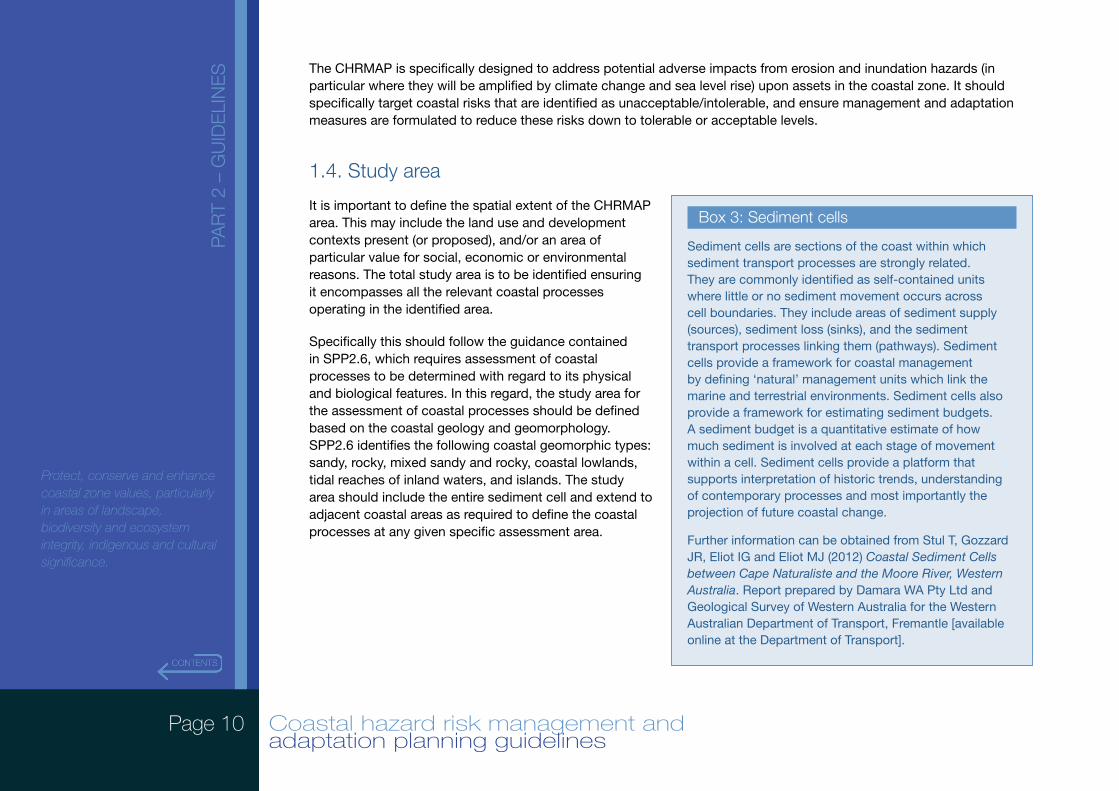
Box 3: Sediment cells
Sediment cells are sections of the coast within which sediment transport processes are strongly related. They are commonly identified as self-contained units where little or no sediment movement occurs across cell boundaries. They include areas of sediment supply (sources), sediment loss (sinks), and the sediment transport processes linking them (pathways). Sediment cells provide a framework for coastal management by defining ‘natural’ management units which link the marine and terrestrial environments. Sediment cells also provide a framework for estimating sediment budgets. A sediment budget is a quantitative estimate of how much sediment is involved at each stage of movement within a cell. Sediment cells provide a platform that supports interpretation of historic trends, understanding of contemporary processes and most importantly the projection of future coastal change.
Further information can be obtained from Stul T, Gozzard JR, Eliot IG and Eliot MJ (2012) Coastal Sediment Cells between Cape Naturaliste and the Moore River, Western Australia. Report prepared by Damara WA Pty Ltd and Geological Survey of Western Australia for the Western Australian Department of Transport, Fremantle [available online at the Department of Transport].
Page 11 Coastal hazard risk management and adaptation planning guidelines
PAR
T 2
– G
UID
ELI
NE
S
Protect, conserve and enhance coastal zone values, particularly in areas of landscape, biodiversity and ecosystem integrity, indigenous and cultural significance.
1.5. Community and stakeholder consultation
It is important to engage the community and stakeholders effectively throughout the entire CHRMAP process and to define their involvement at the outset, especially when developing risk evaluation criteria, to ensure a successful outcome for the risk management process.
The CHRMAP process requires consideration of both coastal hazards and the consequences of those hazards. Assessing those consequences requires a full understanding of the assets, including their function/service and values (natural and man-made) within potentially affected areas.
While determining likely coastal hazards may be done by technical experts, assessing consequences is best done through an open process with input from an informed community and stakeholders. Their viewpoints and values should be reflected when developing the success criteria, which will enable valuable local and regional knowledge bases and information to be drawn on to establish these criteria. Community engagement will assist in:
• determining the consequences and their acceptability or otherwise of a given set of coastal hazards, as these are best determined by those who will be most directly affected by those consequences;
• identifying more innovative risk management and adaptation measures - potential solutions or responses to identified unacceptable/intolerable risks should be sought from as many sources as possible to encourage innovative and locally tailored solutions; and
• acceptance and success of the outcomes of the CHRMAP process given the community’s involvement in the development and ‘ownership’ of the risk assessment/management process.
Community or stakeholder groups might include:
• local communities
• community groups
• land management agencies/councils
• emergency management agencies
• emergency service organisations
• essential services
• local governments, State and Commonwealth government agencies
• science organisations or academia
• industry/business
• industry/business associations
• insurers.
Page 12 Coastal hazard risk management and adaptation planning guidelines
PAR
T 2
– G
UID
ELI
NE
S
Protect, conserve and enhance coastal zone values, particularly in areas of landscape, biodiversity and ecosystem integrity, indigenous and cultural significance.
A key component of designing a community and stakeholder engagement strategy for the CHRMAP is to determine what type of participation is appropriate for each key decision or stage of the process. This could range from seeking to inform or educate through to collaborating with or empowering through participation in decision-making processes.
Determining the most appropriate type of participation should then guide the design of the engagement strategy, including the selection of appropriate engagement mechanisms. Such mechanisms include community reference groups; steering committees; general and specific stakeholder workshops; surveys and questionnaires; public information/education and consultation programs; and the release of a draft document for public feedback.
Community and stakeholder engagement should also be treated as an ongoing process that continues to inform and be informed by the risk management process.
1.5.1. Internal engagement
Internal engagement across all relevant parts of the decision-making organisation will increase the likely effectiveness of the CHRMAP process. Good internal engagement will:
• inform the rest of the organisation of the purpose of the CHRMAP to promote understanding and support across the organisation;
• help identify existing data sets that may be used in the CHRMAP process; and
• provide an understanding of existing planning controls and risk management procedures. This will help to identify processes that already address climate risk and will identify the areas of the organisation most suited to implement adaptation actions (will ensure climate change adaptation is mainstreamed across the organisation and not carried out in isolation).
1.6. Existing planning controls
In managing the coastal zone, a number of planning instruments may be relevant. It is important to identify and summarise the key legislation, policies and guidelines that need to be considered as part of the process including their relevance and how they may inform, complement or enhance this process. These requirements may have a bearing on the assets and their values and ultimately the risk management and adaptation actions. In addition, various adaptation measures identified in the risk assessment process may target amendments to one or more of these instruments.
Such planning instruments may include: the Environment Protection and Biodiversity Conservation Act 1999 (Commonwealth); the Planning and Development Act 2005 (Western Australia); State Planning Policy 2.6 State Coastal
Page 13 Coastal hazard risk management and adaptation planning guidelines
PAR
T 2
– G
UID
ELI
NE
S
Protect, conserve and enhance coastal zone values, particularly in areas of landscape, biodiversity and ecosystem integrity, indigenous and cultural significance.
Planning Policy (and all other planning instruments identified under section 2.3 of this policy); and local planning schemes, structure plans and foreshore management plans.
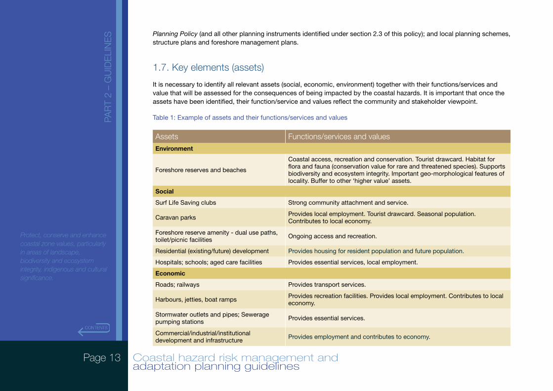
1.7. Key elements (assets)
It is necessary to identify all relevant assets (social, economic, environment) together with their functions/services and value that will be assessed for the consequences of being impacted by the coastal hazards. It is important that once the assets have been identified, their function/service and values reflect the community and stakeholder viewpoint.
Table 1: Example of assets and their functions/services and values
Assets Functions/services and valuesEnvironment
Foreshore reserves and beaches
Coastal access, recreation and conservation. Tourist drawcard. Habitat for flora and fauna (conservation value for rare and threatened species). Supports biodiversity and ecosystem integrity. Important geo-morphological features of locality. Buffer to other ‘higher value’ assets.
Social
Surf Life Saving clubs Strong community attachment and service.
Caravan parks Provides local employment. Tourist drawcard. Seasonal population. Contributes to local economy.
Foreshore reserve amenity - dual use paths, toilet/picnic facilities Ongoing access and recreation.
Residential (existing/future) development Provides housing for resident population and future population.
Hospitals; schools; aged care facilities Provides essential services, local employment.
Economic
Roads; railways Provides transport services.
Harbours, jetties, boat ramps Provides recreation facilities. Provides local employment. Contributes to local economy.
Stormwater outlets and pipes; Sewerage pumping stations Provides essential services.
Commercial/industrial/institutional development and infrastructure Provides employment and contributes to economy.
Page 14 Coastal hazard risk management and adaptation planning guidelines
PAR
T 2
– G
UID
ELI
NE
S
Protect, conserve and enhance coastal zone values, particularly in areas of landscape, biodiversity and ecosystem integrity, indigenous and cultural significance.
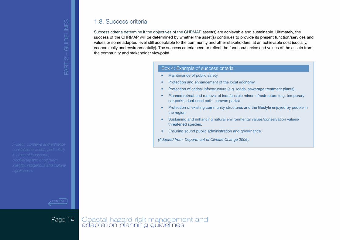
1.8. Success criteria
Success criteria determine if the objectives of the CHRMAP asset(s) are achievable and sustainable. Ultimately, the success of the CHRMAP will be determined by whether the asset(s) continues to provide its present function/services and values or some adapted level still acceptable to the community and other stakeholders, at an achievable cost (socially, economically and environmentally). The success criteria need to reflect the function/service and values of the assets from the community and stakeholder viewpoint.
Box 4: Example of success criteria: • Maintenance of public safety.
• Protection and enhancement of the local economy.
• Protection of critical infrastructure (e.g. roads, sewerage treatment plants).
• Planned retreat and removal of indefensible minor infrastructure (e.g. temporary car parks, dual-used path, caravan parks).
• Protection of existing community structures and the lifestyle enjoyed by people in the region.
• Sustaining and enhancing natural environmental values/conservation values/threatened species.
• Ensuring sound public administration and governance.
(Adapted from: Department of Climate Change 2006).
Page 15 Coastal hazard risk management and adaptation planning guidelines
PAR
T 2
– G
UID
ELI
NE
S
Protect, conserve and enhance coastal zone values, particularly in areas of landscape, biodiversity and ecosystem integrity, indigenous and cultural significance.
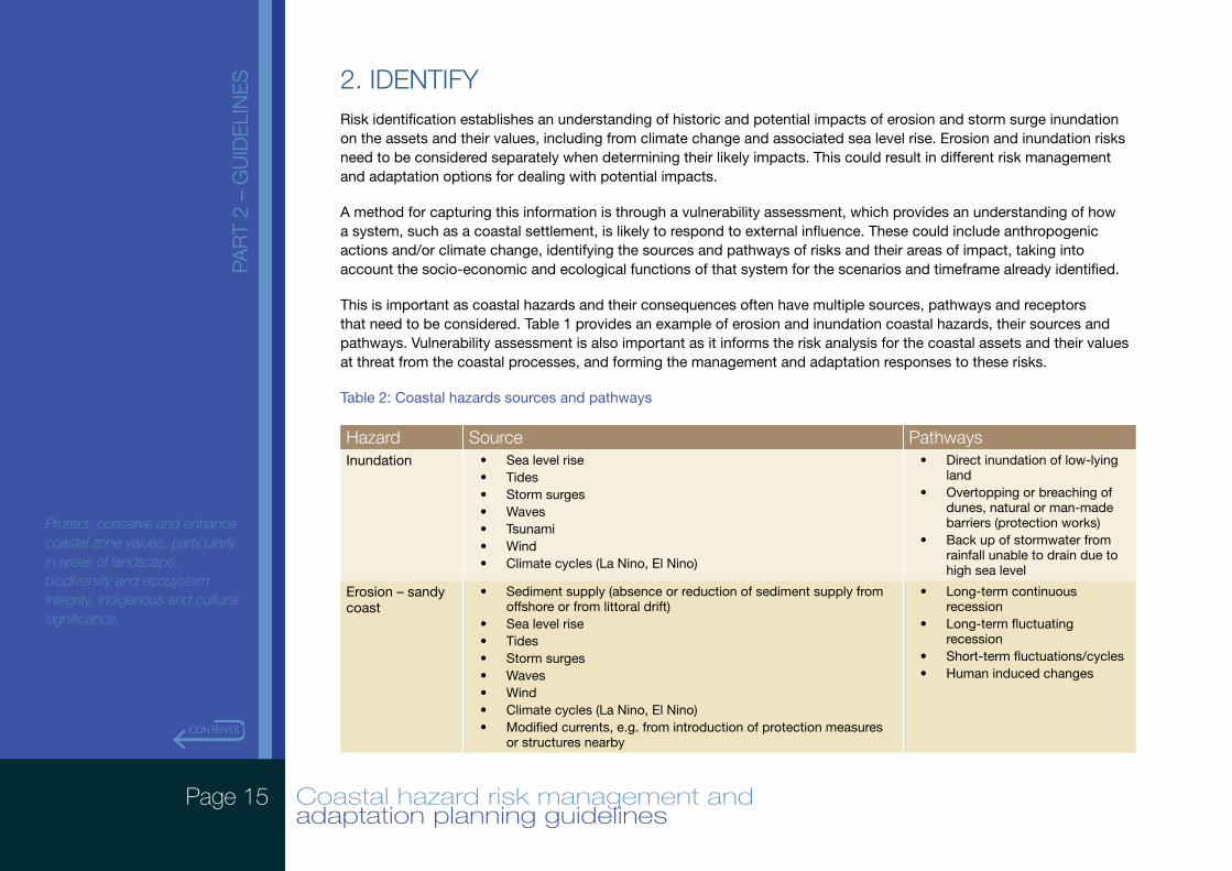
2. IDENTIFYRisk identification establishes an understanding of historic and potential impacts of erosion and storm surge inundation on the assets and their values, including from climate change and associated sea level rise. Erosion and inundation risks need to be considered separately when determining their likely impacts. This could result in different risk management and adaptation options for dealing with potential impacts.
A method for capturing this information is through a vulnerability assessment, which provides an understanding of how a system, such as a coastal settlement, is likely to respond to external influence. These could include anthropogenic actions and/or climate change, identifying the sources and pathways of risks and their areas of impact, taking into account the socio-economic and ecological functions of that system for the scenarios and timeframe already identified.
This is important as coastal hazards and their consequences often have multiple sources, pathways and receptors that need to be considered. Table 1 provides an example of erosion and inundation coastal hazards, their sources and pathways. Vulnerability assessment is also important as it informs the risk analysis for the coastal assets and their values at threat from the coastal processes, and forming the management and adaptation responses to these risks.
Table 2: Coastal hazards sources and pathways
Hazard Source PathwaysInundation • Sea level rise
• Tides• Storm surges• Waves• Tsunami• Wind• Climate cycles (La Nino, El Nino)
• Direct inundation of low-lying land
• Overtopping or breaching of dunes, natural or man-made barriers (protection works)
• Back up of stormwater from rainfall unable to drain due to high sea level
Erosion – sandy coast
• Sediment supply (absence or reduction of sediment supply from offshore or from littoral drift)
• Sea level rise• Tides• Storm surges• Waves• Wind• Climate cycles (La Nino, El Nino)• Modified currents, e.g. from introduction of protection measures
or structures nearby
• Long-term continuous recession
• Long-term fluctuating recession
• Short-term fluctuations/cycles• Human induced changes
Page 16 Coastal hazard risk management and adaptation planning guidelines
PAR
T 2
– G
UID
ELI
NE
S
Protect, conserve and enhance coastal zone values, particularly in areas of landscape, biodiversity and ecosystem integrity, indigenous and cultural significance.
Hazard Source PathwaysErosion – rocky coast
• Geology/geomorphological controls• sea level rise• Tides• Storm surges• Waves• Wind• Climate cycles (La Nino, El Nino)
• Slumping• Undermining• Removal of toe protection• Lowering of shore platform• Lowering of fronting beach• Weathering• Internal defects
Erosion – mixed sandy/rocky coast
• Sediment supply (absence or reduction of sediment supply from offshore or from littoral drift)
• Sea level rise• Tides• Storm surges• Waves• Wind• Climate cycles (La Nino, El Nino)• Modified currents, e.g. from introduction of protection measures
or structures nearby
• Long-term continuous recession
• Long-term fluctuating recession
• Short-term fluctuations/cycles• Human induced changes
Damage to artificial structures
• Changes to sediment transport sources; sinks; and pathways. • Sea level rise• Tides• Storm surges• Waves• Tsunami• Wind• Climate cycles (La Nino, El Nino)• Modified currents, e.g. from introduction of protection measures
or structures nearby
• Undermining• Overtopping• Increased wave forces
(Adapted from Victorian Government 2012)
Page 17 Coastal hazard risk management and adaptation planning guidelines
PAR
T 2
– G
UID
ELI
NE
S
Protect, conserve and enhance coastal zone values, particularly in areas of landscape, biodiversity and ecosystem integrity, indigenous and cultural significance.
2.1. Vulnerability assessment
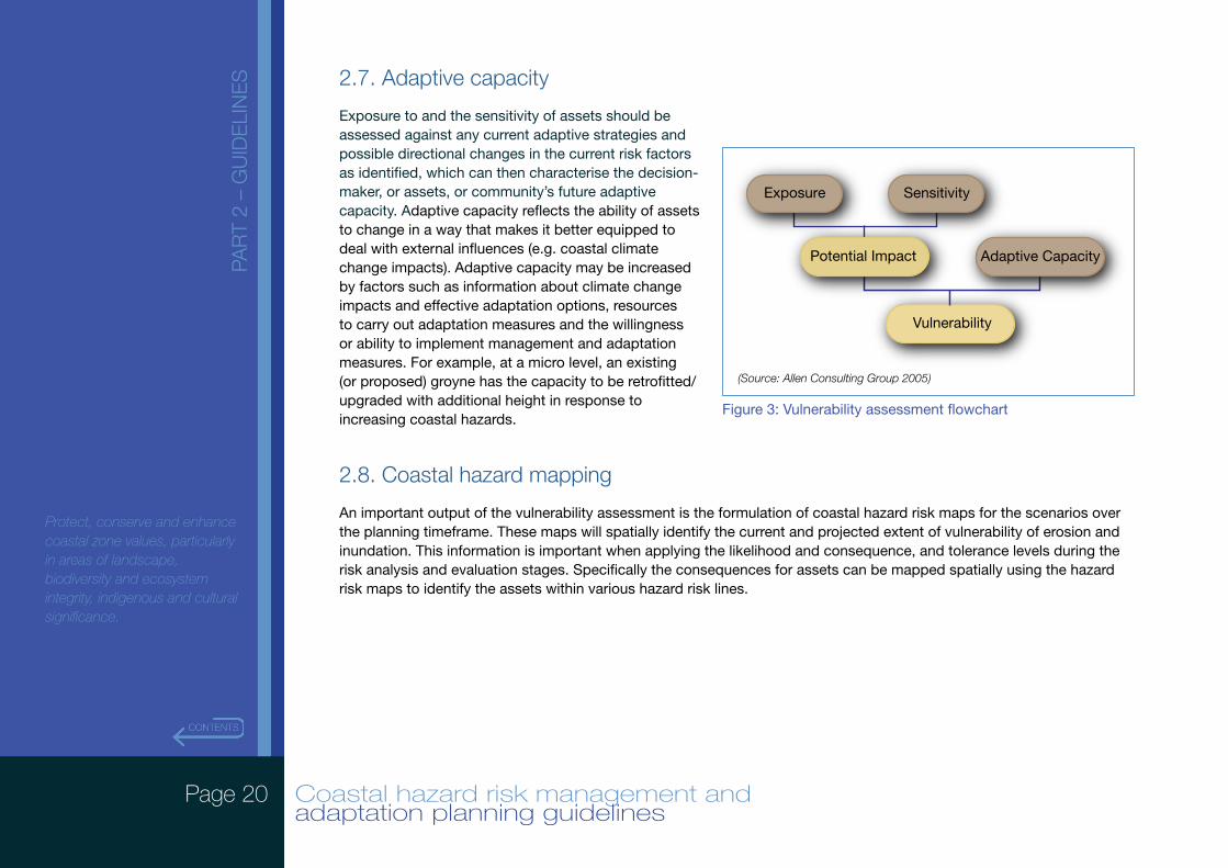
Establishing an understanding of vulnerability of assets in the coastal zone from coastal processes and the associated hazards is important. The vulnerability of coastal assets is a function of three overlapping elements: exposure, sensitivity (to potential impacts) and adaptive capacity of a system. Potential impacts are a function of exposure and sensitivity, while vulnerability is a function of potential impacts and adaptive capacity.
Understanding of the elements’ functions is a basis for helping to describe how the different elements of vulnerability are related to each other. It also assists with identifying threats, opportunities and potential management and adaptation measures arising from climate change, and provides important context and data sources for the coastal hazard risk management and adaptation planning process. Figure 2 illustrates the components of a vulnerability assessment.
2.2. Planning timeframe/climate change scenarios
The planning timeframe and selection of sea level rise and storm event scenarios (applied to erosion and inundation including from storm surge hazards), is critical in determining the climate change projections for extreme events and the potential effects of climate change to be taken into account. It will also highlight the implications for the timing of risk management and adaptation actions that will be identified.
The planning timeframe should typically be 100 years from when the CHRMAP is being prepared, and the scenarios applied within this planning timeframe.
For this Guideline, the term ‘scenarios’ refers to the projections of possible future sea level rise (SLR) and storm events and associated storm surge. Defining these scenarios is complicated and involves some uncertainties, and often a range of projections are produced to reflect the range of feasible future possibilities. Sea level rise and storm event scenarios will influence assessment of the likelihood of coastal erosion and inundation events for the areas assessed and how those likelihoods may vary over the planning timeframe. In completing the CHRMAP, selecting particular years on which to assign SLR and storm projection values is useful. For example, the years 2030, 2070 and 2110 may be used.
Box 5: Vulnerability assessment definition
It is important to note that in Western Australia coastal hazard risk assessments tend to be called vulnerability assessments. However, the term ‘vulnerability assessment’ should only be used where consideration of adaptive capacity is included in the assessment. These guidelines use the vulnerability assessment as part of the ‘Identify’ stage in the CHRMAP process, consistent with Australian and international standards for vulnerability assessment that require adaptive capacity to be assessed.
Page 18 Coastal hazard risk management and adaptation planning guidelines
PAR
T 2
– G
UID
ELI
NE
S
Protect, conserve and enhance coastal zone values, particularly in areas of landscape, biodiversity and ecosystem integrity, indigenous and cultural significance.
The sea level is expected to rise over time; however there are various scenarios on the extent of the SLR and the future trends in storm intensity and frequency. Selecting a small number of different SLR and storm event scenarios allows analysis of the risk or impact to identified assets over time, which will help determine when management and adaptation actions should be taken.
In accordance with SPP2.6, a SLR not less than 0.9 metres by 2110 is to be taken into account. It is also important that the vulnerability assessment consider shorter and possibly longer timeframe periods while maintaining consistency with SPP2.6. Consistency will be achieved by ensuring other timeframe and SLR scenarios are in accordance with those contained in the Sea Level Change In Western Australia Application To Coastal Planning (2010) document.
Storm event scenarios for erosion should be those that will involve the ocean forces and coastal processes that have a one per cent or one-in-one hundred probability of being equalled or exceeded in any given year.
Storm event scenarios for inundation should be those that will involve the ocean forces and coastal processes that have at least a 0.2 per cent or one-in-five hundred probability of being equalled or exceeded in any given year plus the predicted extent of sea level rise.
2.3. Structures
As part of the vulnerability assessment it is important to consider any existing control structures, including natural defences such as dunes or heavily vegetated areas, or natural rock structures. It will also be important to consider the condition of any existing control structure; a sea wall may exist but may be in a severely degraded state, sot will have limited utility as a control structure unless it is upgraded and maintained.
Box 6: Erosion and inundation controls
Storm surge inundation controls may include sea walls, dunes, foreshore reserves, state planning policy, development controls, local planning scheme provisions and emergency evacuation management plans. Erosion controls should be explicitly listed and may include sea walls, dunes, foreshore reserves, development controls, local planning scheme provisions, erosion control planting; groynes, artificial reefs, break waters and erosion monitoring and reporting.
Page 19 Coastal hazard risk management and adaptation planning guidelines
PAR
T 2
– G
UID
ELI
NE
S
Protect, conserve and enhance coastal zone values, particularly in areas of landscape, biodiversity and ecosystem integrity, indigenous and cultural significance.
2.4. Exposure
Exposure is the assessment of the physical processes that impact on an asset. Elements such as the geology, geomorphology, sediment dynamics and variability, bathymetry, water levels, wind and waves are documented and any other elements (such as existing engineered controls) that affect the system are identified and assessed, with the focus being on storm surge inundation and erosion. Exposure represents the background climate conditions within which assets are situated and any changes in those conditions.
The assessment should follow the methodologies in Schedule One of SPP2.6. The allowance for coastal processes should be based on the coastal classification, and consider each of the factors listed for the coastal types. The study area for this calculation should be defined through the coastal geology/geomorphology, including the entire sediment cell and include adjacent coastal areas as required.
• Where applicable the allowance for erosion should be based on:
• (S1 Erosion) Allowance for the current risk of erosion;
• (S2 Erosion) Allowance for historic shoreline movement trends; and
• (S3 Erosion) Allowance for erosion caused by future sea level rise.
For inundation the allowance should be based on:
• (S4 Inundation) Allowance for the current risk of storm surge inundation.
2.5. Sensitivity
Sensitivity reflects the responsiveness of assets to climatic influences, and the degree to which changes in climate might affect this responsiveness. Sensitive assets are highly responsive to climate and climate change. Understanding assets sensitivity also requires an understanding of the thresholds at which it begins to exhibit changes in response to climate influences, whether these asset responses or adjustments are likely to be sudden ‘step changes’ or gradual, and the degree to which these changes are reversible.
2.6. Potential impacts
This reflects all the potential impacts that may occur to assets through any environmental changes and is a product of the exposure and sensitivity of those assets. However, it does not include consideration of any planned adaptation.
Page 20 Coastal hazard risk management and adaptation planning guidelines
PAR
T 2
– G
UID
ELI
NE
S
Protect, conserve and enhance coastal zone values, particularly in areas of landscape, biodiversity and ecosystem integrity, indigenous and cultural significance.
2.7. Adaptive capacity
Exposure to and the sensitivity of assets should be assessed against any current adaptive strategies and possible directional changes in the current risk factors as identified, which can then characterise the decision-maker, or assets, or community’s future adaptive capacity. Adaptive capacity reflects the ability of assets to change in a way that makes it better equipped to deal with external influences (e.g. coastal climate change impacts). Adaptive capacity may be increased by factors such as information about climate change impacts and effective adaptation options, resources to carry out adaptation measures and the willingness or ability to implement management and adaptation measures. For example, at a micro level, an existing (or proposed) groyne has the capacity to be retrofitted/upgraded with additional height in response to increasing coastal hazards.
2.8. Coastal hazard mapping
An important output of the vulnerability assessment is the formulation of coastal hazard risk maps for the scenarios over the planning timeframe. These maps will spatially identify the current and projected extent of vulnerability of erosion and inundation. This information is important when applying the likelihood and consequence, and tolerance levels during the risk analysis and evaluation stages. Specifically the consequences for assets can be mapped spatially using the hazard risk maps to identify the assets within various hazard risk lines.
Vulnerability
Potential Impact
Exposure Sensitivity
Adaptive Capacity
(Source: Allen Consulting Group 2005)
Figure 3: Vulnerability assessment flowchart
Page 21 Coastal hazard risk management and adaptation planning guidelines
PAR
T 1
– O
VE
RV
IEW
Coastal zones are vulnerable to adverse impacts from inundation and erosion. The risk to the environment from climate change is influenced by the level of preparedness and response of the community and its recovery capacity.
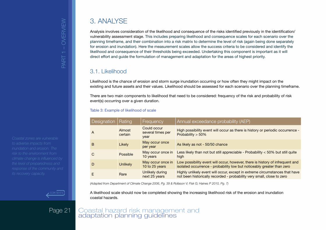
3. ANALYSEAnalysis involves consideration of the likelihood and consequence of the risks identified previously in the identification/vulnerability assessment stage. This includes preparing likelihood and consequence scales for each scenario over the planning timeframe, and their combination into a risk matrix to determine the level of risk (again being done separately for erosion and inundation). Here the measurement scales allow the success criteria to be considered and identify the likelihood and consequence of their thresholds being exceeded. Undertaking this component is important as it will direct effort and guide the formulation of management and adaptation for the areas of highest priority.
3.1. Likelihood
Likelihood is the chance of erosion and storm surge inundation occurring or how often they might impact on the existing and future assets and their values. Likelihood should be assessed for each scenario over the planning timeframe.
There are two main components to likelihood that need to be considered: frequency of the risk and probability of risk event(s) occurring over a given duration.
Table 3: Example of likelihood of scale
Designation Rating Frequency Annual exceedance probability (AEP)
A Almost certain
Could occur several times per year
High possibility event will occur as there is history or periodic occurrence - Probability > 50%
B Likely May occur once per year As likely as not - 50/50 chance
C Possible May occur once in 10 years
Less likely than not but still appreciable - Probability < 50% but still quite high
D Unlikely May occur once in 10 to 25 years
Low possibility event will occur, however, there is history of infrequent and isolated occurrence - probability low but noticeably greater than zero
E Rare Unlikely during next 25 years
Highly unlikely event will occur, except in extreme circumstances that have not been historically recorded - probability very small, close to zero
(Adapted from Department of Climate Change 2006, Pg. 39 & Rollason V; Fisk G; Haines P 2010, Pg. 7)
A likelihood scale should now be completed showing the increasing likelihood risk of the erosion and inundation coastal hazards.
Page 22 Coastal hazard risk management and adaptation planning guidelines
PAR
T 2
– G
UID
ELI
NE
S
Protect, conserve and enhance coastal zone values, particularly in areas of landscape, biodiversity and ecosystem integrity, indigenous and cultural significance.
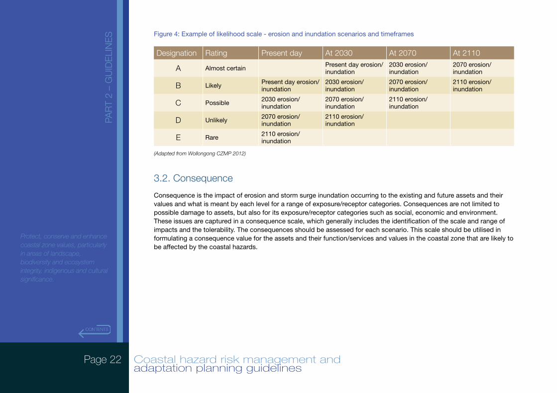
Figure 4: Example of likelihood scale - erosion and inundation scenarios and timeframes
Designation Rating Present day At 2030 At 2070 At 2110
A Almost certain Present day erosion/inundation
2030 erosion/inundation
2070 erosion/inundation
B Likely Present day erosion/inundation
2030 erosion/inundation
2070 erosion/inundation
2110 erosion/inundation
C Possible 2030 erosion/inundation
2070 erosion/inundation
2110 erosion/inundation
D Unlikely 2070 erosion/inundation
2110 erosion/inundation
E Rare 2110 erosion/inundation
(Adapted from Wollongong CZMP 2012)
3.2. Consequence
Consequence is the impact of erosion and storm surge inundation occurring to the existing and future assets and their values and what is meant by each level for a range of exposure/receptor categories. Consequences are not limited to possible damage to assets, but also for its exposure/receptor categories such as social, economic and environment. These issues are captured in a consequence scale, which generally includes the identification of the scale and range of impacts and the tolerability. The consequences should be assessed for each scenario. This scale should be utilised in formulating a consequence value for the assets and their function/services and values in the coastal zone that are likely to be affected by the coastal hazards.
Page 23 Coastal hazard risk management and adaptation planning guidelines
PAR
T 2
– G
UID
ELI
NE
S
Protect, conserve and enhance coastal zone values, particularly in areas of landscape, biodiversity and ecosystem integrity, indigenous and cultural significance.
Table 5: Example of a consequence scale for coastal hazards
Designation Rating Social Economic Environment
1 Catastrophic
Loss of life and serious injury. Large long-term or permanent loss of services, employment wellbeing, finances or culture (e.g. > 75% of community affected), international loss, no suitable alternative sites exist.
Permanent loss or damage to property, plant and equipment, finances > $5 million.
Permanent loss of flora and fauna (no chance of recovery) with national impact.
2 Major
Serious injury. Medium-term disruption to services, employment wellbeing, finances or culture (e.g. < 50% of community affected), national loss, very limited suitable alternative sites exist.
Permanent loss or damage to property, plant and equipment, finances > $2 - $5 million.
Long-term loss of flora and fauna (limited chance of recovery) with regional impact.
3 Moderate
Minor injury. Major short-term or minor long-term disruption to services, employment wellbeing, finances or culture (e.g. < 25% of community affected), regional loss, limited suitable alternative sites exist.
Permanent loss or damage to property, plant and equipment, finances > $100,000 - $2 million
Medium-term loss of flora and fauna (recovery likely) with regional impact.
4 Minor
Small to medium disruption to services, employment wellbeing, finances or culture (e.g. < 10% of community affected), local loss, many suitable alternative sites exist.
Permanent loss or damage to property, plant and equipment, finances > $10,000 - $100,000.
Short-term loss of flora and fauna (strong recovery) with local impact.
5 Insignificant
Minimal short-term inconveniences to services, employment, wellbeing, finances or culture (e.g. < 5% of community affected), neighbourhood loss, many alternative sites exist.
Permanent loss or damage to property, plant and equipment, finances < $10,000.
Negligible to no loss of flora and fauna (strong recovery) with local impact.
(Adapted from Ministry for the Environment 2008, Xviii & 149p. – Pg, 78 & Wollongong CZMP 2012))
Now that an understanding of the consequences has been established, they can be associated with the assets, their service/functions and values identified above.
Page 24 Coastal hazard risk management and adaptation planning guidelines
PAR
T 2
– G
UID
ELI
NE
S
Protect, conserve and enhance coastal zone values, particularly in areas of landscape, biodiversity and ecosystem integrity, indigenous and cultural significance.
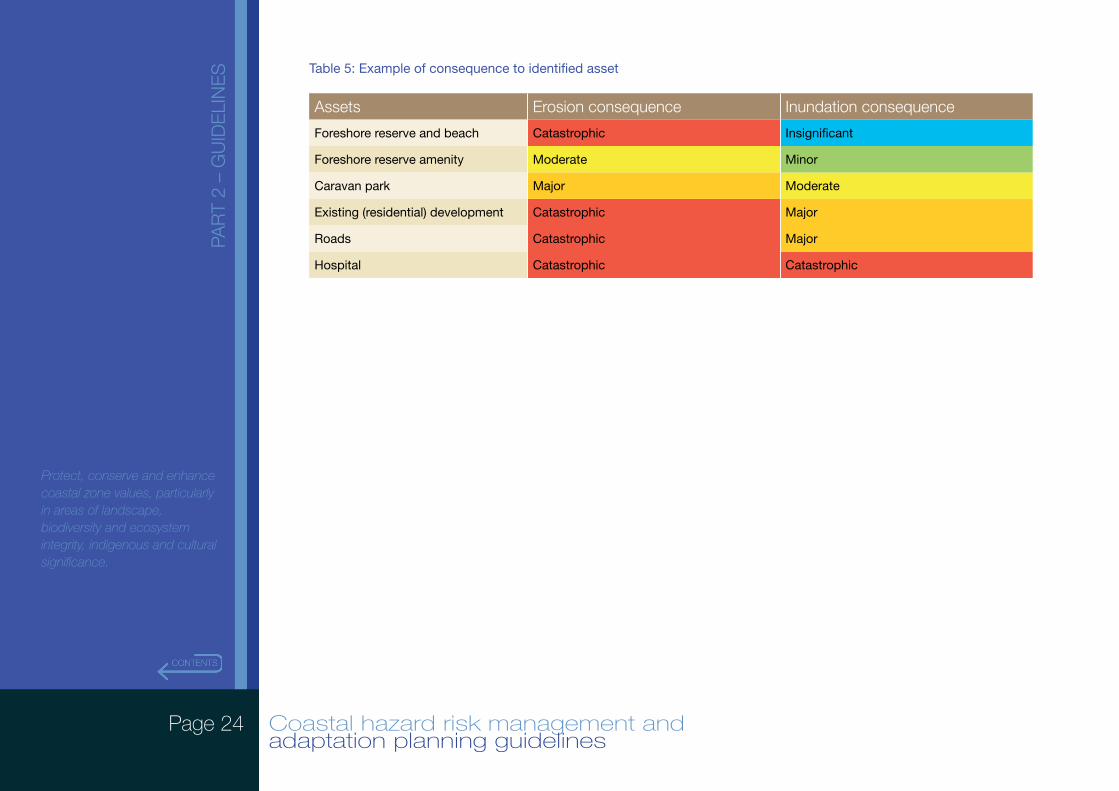
Table 5: Example of consequence to identified asset
Assets Erosion consequence Inundation consequence
Foreshore reserve and beach Catastrophic Insignificant
Foreshore reserve amenity Moderate Minor
Caravan park Major Moderate
Existing (residential) development Catastrophic Major
Roads Catastrophic Major
Hospital Catastrophic Catastrophic
Page 25 Coastal hazard risk management and adaptation planning guidelines
PAR
T 2
– G
UID
ELI
NE
S
Protect, conserve and enhance coastal zone values, particularly in areas of landscape, biodiversity and ecosystem integrity, indigenous and cultural significance.
4. EVALUATEEvaluation of the risk analysis is about prioritising risk management and adaptation. It is an important part of the process as it may not be possible or necessary to treat every risk. Also, the cost of implementing management and adaptation measures may outweigh the benefits gained. In prioritising management and adaptation actions, comparison of the results of the risk analysis is undertaken to determine the acceptability/tolerability, unacceptability/intolerability of the risks based on the outcomes of the risk assessment.
4.1. Risk scale
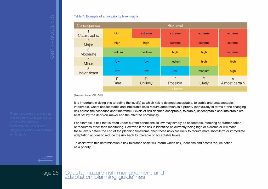
It is important to establish the risk priority scale as it identifies priority of actions as arising from the likelihood and consequence scales. Four levels of risk are typically defined as:
• Extreme – risks are unacceptable/intolerable, requiring immediate management and adaptation action.
• High – risks are the most severe that can be tolerated and need monitoring in the short term as management and adaptation action is likely to be needed in the short-term.
• Medium – risk can be tolerated and need monitoring in the short to medium term.
• Low – risk can be accepted, no actions will be required in the short to medium term.
(Source: Adapted from Commonwealth of Australia, 2006)
Page 26 Coastal hazard risk management and adaptation planning guidelines
PAR
T 2
– G
UID
ELI
NE
S
Protect, conserve and enhance coastal zone values, particularly in areas of landscape, biodiversity and ecosystem integrity, indigenous and cultural significance.
Table 7: Example of a risk priority level matrix
Consequence Risk level
1 Catastrophic
high extreme extreme extreme extreme
2 Major
high high extreme extreme extreme
3 Moderate
medium medium high high extreme
4 Minor
low low medium high high
5 Insignificant
low low low medium high
E Rare
D Unlikely
C Possible
B Likely
A Almost certain
Likelihood
(Adapted from CZM 2009)
It is important in doing this to define the level(s) at which risk is deemed acceptable, tolerable and unacceptable, intolerable, where unacceptable and intolerable risks require adaptation as a priority (particularly in terms of the changing risk across the scenarios and timeframe). Levels of risk deemed acceptable, tolerable, unacceptable and intolerable are best set by the decision-maker and the affected community.
For example, a risk that is rated under current conditions as low may simply be acceptable, requiring no further action or resources other than monitoring. However, if the risk is identified as currently being high or extreme or will reach these levels before the end of the planning timeframe, then these risks are likely to require more short-term or immediate adaptation actions to reduce the risk back to tolerable or acceptable levels.
To assist with this determination a risk tolerance scale will inform which risk, locations and assets require action as a priority.
Page 27 Coastal hazard risk management and adaptation planning guidelines
PAR
T 2
– G
UID
ELI
NE
S
Protect, conserve and enhance coastal zone values, particularly in areas of landscape, biodiversity and ecosystem integrity, indigenous and cultural significance.
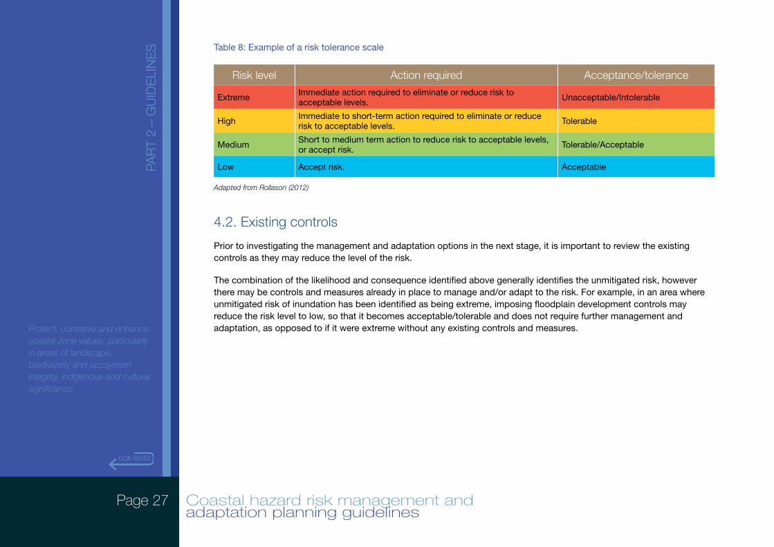
Table 8: Example of a risk tolerance scale
Risk level Action required Acceptance/tolerance
Extreme Immediate action required to eliminate or reduce risk to acceptable levels. Unacceptable/Intolerable
High Immediate to short-term action required to eliminate or reduce risk to acceptable levels. Tolerable
Medium Short to medium term action to reduce risk to acceptable levels, or accept risk. Tolerable/Acceptable
Low Accept risk. Acceptable
Adapted from Rollason (2012)
4.2. Existing controls
Prior to investigating the management and adaptation options in the next stage, it is important to review the existing controls as they may reduce the level of the risk.
The combination of the likelihood and consequence identified above generally identifies the unmitigated risk, however there may be controls and measures already in place to manage and/or adapt to the risk. For example, in an area where unmitigated risk of inundation has been identified as being extreme, imposing floodplain development controls may reduce the risk level to low, so that it becomes acceptable/tolerable and does not require further management and adaptation, as opposed to if it were extreme without any existing controls and measures.
Page 28 Coastal hazard risk management and adaptation planning guidelines
PAR
T 2
– G
UID
ELI
NE
S
Protect, conserve and enhance coastal zone values, particularly in areas of landscape, biodiversity and ecosystem integrity, indigenous and cultural significance.
5. RISK MANAGEMENT AND ADAPTATIONRisk management and adaptation is about how to respond to the identified coastal hazard risks. Risk management and adaptation options should be described and assessed including both a cost benefit analysis (or a real options analysis) and a multi-criteria analysis to assist with identifying options that provide the greatest benefit (relative to cost and other key criteria) in treating the highest priority risks. The economic, environmental, and social costs and benefits of options need to be considered in these analyses.
Risk management and adaptation options need to be assessed in terms of their:
• potential benefits;
• effectiveness in reducing losses; or maximising opportunities;
• cost of implementation and ongoing maintenance;
• equity implications (e.g. which stakeholders bear costs of options?; are the costs and/or benefits shifted between stakeholders and if so is this fair and acceptable?; whose values are being protected and/or negatively impacted?); and
• impact of the treatment option on other objectives, including the introduction of new risks or issues.
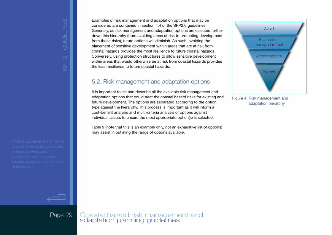
5.1. Risk management and adaptation hierarchy
Challenges to managing risks arising from coastal hazards include long timeframes associated with changing coastal environments and uncertainties that arise from complex climatic and coastal systems. In assessing potential risk adaptation options, it is important to consider the ability of future decision-makers to maintain future decision-making flexibility. This involves assessing the potential of a risk adaptation option to restrict future risk adaptation opportunities.
Risk management and adaptation options that maintain a wide range of potential future risk management options should always be considered more favourably than those that (either directly or indirectly) act to limit future risk management options. By allowing a greater range of risk management and adaptation options to be considered by future decision makers, processes can more effectively address the challenges of uncertainty and long timeframes associated with coastal hazards. Effectively, this concept of maintaining future flexibility is about creating coastal communities that are resilient to the uncertainties of planning in coastal environments.
It is on this rationale that the risk management and adaptation hierarchy (Figure 4) has been established, where ‘Avoid’, ‘Planned or Managed Retreat’, ‘Accommodate’ and ‘Protect’ refer to four broad categories of potential adaptation options.
Page 29 Coastal hazard risk management and adaptation planning guidelines
PAR
T 2
– G
UID
ELI
NE
S
Protect, conserve and enhance coastal zone values, particularly in areas of landscape, biodiversity and ecosystem integrity, indigenous and cultural significance.
Examples of risk management and adaptation options that may be considered are contained in section 4.4 of the SPP2.6 guidelines. Generally, as risk management and adaptation options are selected further down this hierarchy (from avoiding areas at risk to protecting development from those risks), future options will diminish. As such, avoiding the placement of sensitive development within areas that are at risk from coastal hazards provides the most resilience to future coastal hazards. Conversely, using protection structures to allow sensitive development within areas that would otherwise be at risk from coastal hazards provides the least resilience to future coastal hazards.
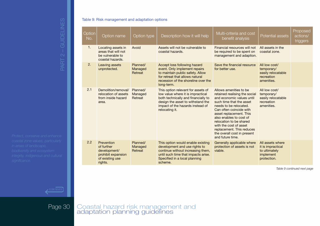
5.2. Risk management and adaptation options
It is important to list and describe all the available risk management and adaptation options that could treat the coastal hazard risks for existing and future development. The options are separated according to the option type against the hierarchy. This process is important as it will inform a cost-benefit analysis and multi-criteria analysis of options against individual assets to ensure the most appropriate option(s) is selected.
Table 9 (note that this is an example only, not an exhaustive list of options) may assist in outlining the range of options available.
Avoid
Planned or managed retreat
Accommodate
Protect
Figure 4: Risk management and adaptation hierarchy
Page 30 Coastal hazard risk management and adaptation planning guidelines
PAR
T 2
– G
UID
ELI
NE
S
Protect, conserve and enhance coastal zone values, particularly in areas of landscape, biodiversity and ecosystem integrity, indigenous and cultural significance.
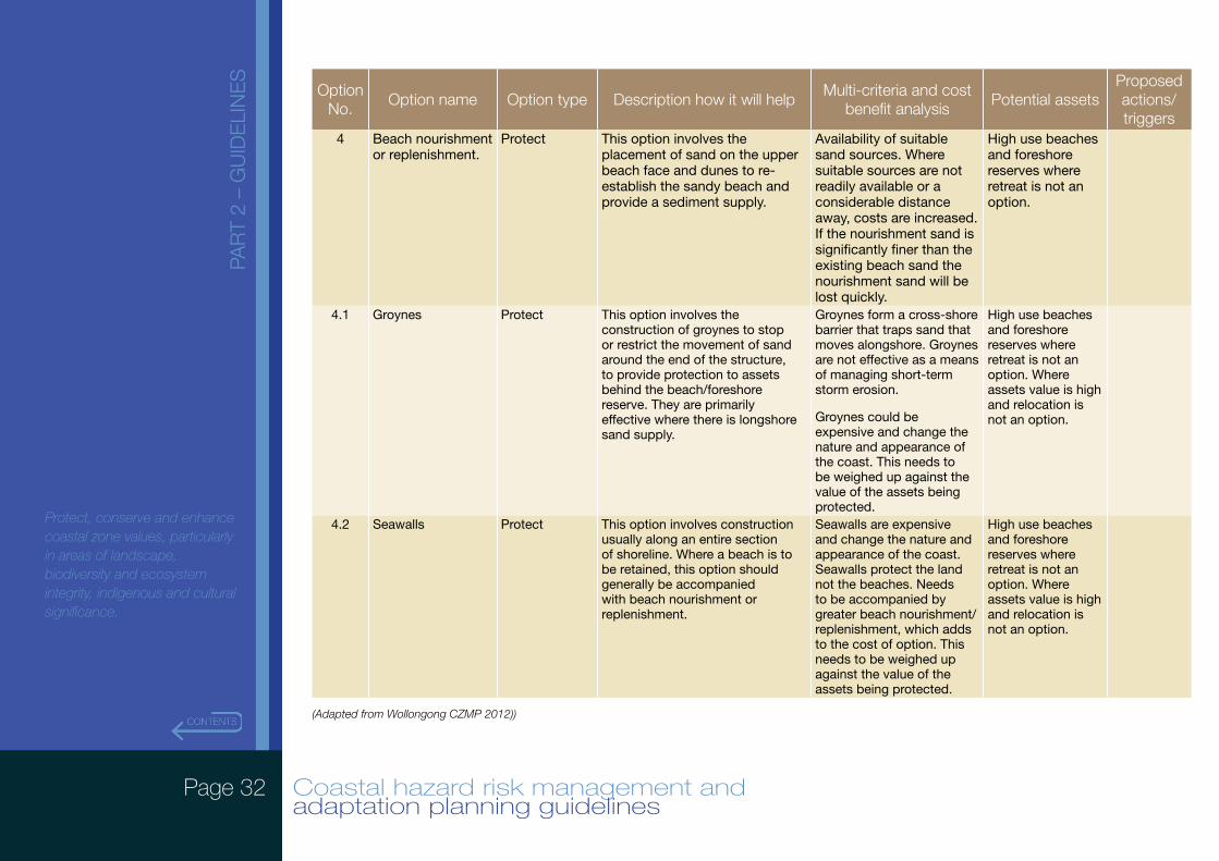
Table 9: Risk management and adaptation options
Option No.
Option name Option type Description how it will helpMulti-criteria and cost
benefit analysisPotential assets
Proposed actions/triggers
1. Locating assets in areas that will not be vulnerable to coastal hazards.
Avoid Assets will not be vulnerable to coastal hazards.
Financial resources will not be required to be spent on management and adaption.
All assets in the coastal zone.
2. Leaving assets unprotected.
Planned/Managed Retreat
Accept loss following hazard event. Only implement repairs to maintain public safety. Allow for retreat that allows natural recession of the shoreline over the long-term.
Save the financial resource for better use.
All low cost/temporary/easily relocatable recreation amenities.
2.1 Demolition/removal/relocation of assets from inside hazard area.
Planned/Managed Retreat
This option relevant for assets of low value where it is impractical both technically and financially to design the asset to withstand the impact of the hazards instead of relocating it.
Allows amenities to be retained realising the social and economic values until such time that the asset needs to be relocated. Can often coincide with asset replacement. This also enables to cost of relocation to be shared with the cost of asset replacement. This reduces the overall cost in present and future time.
All low cost/temporary/easily relocatable recreation amenities.
2.2 Prevention of further development/prohibit expansion of existing use rights.
Planned/Managed Retreat
This option would enable existing development and use rights to continue without increasing them, until such time that impacts arise. Specified in a local planning scheme.
Generally applicable where protection of assets is not viable.
All assets where it is impractical to ultimately implement protection.
Table 9 continued next page
Page 31 Coastal hazard risk management and adaptation planning guidelines
PAR
T 2
– G
UID
ELI
NE
S
Protect, conserve and enhance coastal zone values, particularly in areas of landscape, biodiversity and ecosystem integrity, indigenous and cultural significance.
Option No.
Option name Option type Description how it will helpMulti-criteria and cost
benefit analysisPotential assets
Proposed actions/triggers
3. Notification on title (can also be relevant to (planned/managed retreat and protect options).
Accommodate Indicates to current and future land owners that an asset is likely to be affected by coastal erosion and/or inundation over the planning timeframe. Helps current and future owners make informed decision about level of risk they are/may be willing to accept and that risk management and adaptation is likely to be required at some stage in within the planning timeframe.
This option allows vulnerability of asset to hazards to be conveyed to existing and future owners. One means of implementation that is low cost, is through decision-making for subdivision and development.
All assets located within an area vulnerable to the adverse impacts of coastal erosion and inundation within the planning timeframe.
3.1 Emergency evacuation plans.
Accommodate Where existing assets may be affected by inundation and are not already identified in an existing emergency evacuation management plan. Such plans are important in managing the safety of community and stakeholders.
This option is a low cost option in addressing the consequences of inundation with regard to safety to lives as the impact occurs.
Roads (with particular regard to managing traffic flows during an event), car parks, residential property, hospitals, aged care facilities, schools, child care facilities, surf life saving clubs.
3.2 Design assets to withstand impacts.
Accommodate Where avoiding or relocating an asset is not an option, design of assets to withstand the impact of inundation.
This option is aimed at retaining existing assets in locations but reducing the consequences of the inundation hazard. It is cheaper to mitigate the impacts with initial design outcomes as opposed to retrofitting existing assets in the future.
Roads, car parks, residential property, hospitals, aged care facilities, schools, child care facilities, surf life saving clubs.
Table 9 continued next page
Page 32 Coastal hazard risk management and adaptation planning guidelines
PAR
T 2
– G
UID
ELI
NE
S
Protect, conserve and enhance coastal zone values, particularly in areas of landscape, biodiversity and ecosystem integrity, indigenous and cultural significance.
Option No.
Option name Option type Description how it will helpMulti-criteria and cost
benefit analysisPotential assets
Proposed actions/triggers
4 Beach nourishment or replenishment.
Protect This option involves the placement of sand on the upper beach face and dunes to re-establish the sandy beach and provide a sediment supply.
Availability of suitable sand sources. Where suitable sources are not readily available or a considerable distance away, costs are increased. If the nourishment sand is significantly finer than the existing beach sand the nourishment sand will be lost quickly.
High use beaches and foreshore reserves where retreat is not an option.
4.1 Groynes Protect This option involves the construction of groynes to stop or restrict the movement of sand around the end of the structure, to provide protection to assets behind the beach/foreshore reserve. They are primarily effective where there is longshore sand supply.
Groynes form a cross-shore barrier that traps sand that moves alongshore. Groynes are not effective as a means of managing short-term storm erosion.
Groynes could be expensive and change the nature and appearance of the coast. This needs to be weighed up against the value of the assets being protected.
High use beaches and foreshore reserves where retreat is not an option. Where assets value is high and relocation is not an option.
4.2 Seawalls Protect This option involves construction usually along an entire section of shoreline. Where a beach is to be retained, this option should generally be accompanied with beach nourishment or replenishment.
Seawalls are expensive and change the nature and appearance of the coast. Seawalls protect the land not the beaches. Needs to be accompanied by greater beach nourishment/replenishment, which adds to the cost of option. This needs to be weighed up against the value of the assets being protected.
High use beaches and foreshore reserves where retreat is not an option. Where assets value is high and relocation is not an option.
(Adapted from Wollongong CZMP 2012))
Page 33 Coastal hazard risk management and adaptation planning guidelines
PAR
T 2
– G
UID
ELI
NE
S
Protect, conserve and enhance coastal zone values, particularly in areas of landscape, biodiversity and ecosystem integrity, indigenous and cultural significance.
5.3. Comparative evaluation of risk management and adaptation options (cost benefit analysis and multi-criteria analysis)
Having identified the risk management and adaptation options available it is necessary to assess them against the identified assets (and their functions/services and values) in terms of their benefits and costs (economic, social and environmental).
There is no single methodology that applies to this situation. However an effective approach is to combine two appraisal techniques: multi-criteria analysis (MCA) and cost benefit analysis (CBA).
CBA assists by determining which option(s) should be chosen by enabling the different options available to be compared against each-other in terms of their quantifiable forecast cost and forecast benefits, to see whether the benefits outweigh the costs. CBA is a quantitative assessment of financial data.
An alternative economic evaluation method is a real options analysis. While more complicated, this method can better incorporate into the analysis the benefits of delaying decisions on some adaptation options until more information is available to decision makers.
Considerations of potential benefits and costs when treating a risk needs to go beyond direct economic costs, and incorporate social and environment values. For example, what may be the most cost-effective option may not always be considered the most effective by the community if it is likely to place large value on non-monetary assets (e.g. parks and beaches, social and cultural values). Assets may also provide important ecosystem services that are difficult to quantify. Estimates of social and environmental values can be explored using a number of both quantitative and qualitative methods, such as benefit transfer or using qualitative methods and holding workshops with the community.
MCA (is a qualitative assessment of social and environmental information) involves evaluating the risk management and adaptation options being considered against the other key criteria listed in Section 5 above. In some cases it is difficult to quantify in dollar terms and therefore not easily or accurately incorporated into a CBA. The MCA can assist in complementing, and addressing the limitations of the CBA. Results of the MCA in combination with the CBA will provide a more robust evidence base for decisions.
This step is important as it assists in the selection of the set of options that are most likely to effectively and efficiently achieve the success criteria the coastal hazard risk management and adaptation planning is measured against. It will also help prioritise the most beneficial options, where there is more than one that may be appropriate for the management and adaptation of an asset to coastal hazards.
Page 34 Coastal hazard risk management and adaptation planning guidelines
PAR
T 2
– G
UID
ELI
NE
S
Protect, conserve and enhance coastal zone values, particularly in areas of landscape, biodiversity and ecosystem integrity, indigenous and cultural significance.
5.4. Recommended risk level and management and adaptation options
Once the risk management and adaptation options have been identified and a cost-benefit analysis and multi-criteria analysis undertaken, the options most suitable for addressing the various risks can be identified against assets on a specific basis. It is important that the chosen option is generally the most cost-effective, which provides the highest over-all benefit, while also being acceptable against the other evaluation criteria.
It is important that options are identified against the risks at the timeframes identified above in the vulnerability assessment, and that the options do not make it more difficult for future decision-making to manage and adapt to the risks.
5.5. Implementation plan
Having identified risk management and adaptation options for specific assets, it is important that the actions are implemented. This can be done through an implementation plan, which details actions to be undertaken to implement the selected risk management and adaptation option(s). The plan should include:
• Proposed actions – what is the selected management and/or adaptation option(s)?
• Resource requirements – what is required to implement the option?
• Responsibility – who will be responsible for the implementation (management and adaptation owner)?
• Timing – the timeframe(s) for option implementation?
• Performance measures – what will be the indicators that demonstrate progress of implementation and effectiveness of the option?
• Reporting and monitoring – who will need to be informed during and at completion of implementation of the option and how will the implementation be monitored and how frequently?
Page 35 Coastal hazard risk management and adaptation planning guidelines
PAR
T 2
– G
UID
ELI
NE
S
Protect, conserve and enhance coastal zone values, particularly in areas of landscape, biodiversity and ecosystem integrity, indigenous and cultural significance.
6. MONITOR AND REVIEWRegular monitoring and reviewing the coastal hazard risk management and adaptation planning will ensure that the management and adaptation planning identified and established remains relevant. This effectively converts it from a one-off linear process to a cyclical process.
This process is crucial as risks arising from coastal hazards rarely remain static, especially as our understanding of coastal processes is improving and given the long timeframes associated with some types of coastal processes and types of land use and development in the coastal zone. It is also impacted by uncertainty on the degree of future climate change (i.e. what the future global greenhouse emissions will be), and climate change projections that are used in the vulnerability assessments. Monitoring and reviewing the CHRMAP ensure the management and adaptation to reduce risks, their likelihood and consequences and the risk priorities, remain the most suitable and effective, and timing and cost appropriate. Where possible principles of adaptive management should be applied which involves small, flexible, incremental changes based on regular monitoring and revision of plans based on the best information available at the time.
Monitoring and reviewing should also always include the community and stakeholders to ensure any changes are communicated, and their viewpoints and values are continuously reflected in the management and adaptation outcomes.
Monitoring and reviewing keeps analysis and evaluation updated by providing a mechanism for feeding in new information about climate change impacts, tracking progress on actions flowing from the risk management process, and ensuring that the process itself is implemented in a timely and cost-effective fashion.
Page 36 Coastal hazard risk management and adaptation planning guidelines
PAR
T 2
– G
UID
ELI
NE
S
Protect, conserve and enhance coastal zone values, particularly in areas of landscape, biodiversity and ecosystem integrity, indigenous and cultural significance.
7. COMMUNICATION OF RESULTSThe results of the coastal hazard risk management and adaptation planning process should be documented and communicated broadly. Local Councils should develop a communication plan to disseminate the results both within their own organisation and where relevant, to external stakeholders and the community. The results should be presented widely to councillors and all relevant staff (e.g. land use planning, operations, senior management, CEO).
A communication plan might include:
• briefings/workshops/reports to elected councillors;
• meetings;
• staff circulars or updates in staff newsletters; and
• information workshops for different areas of the council.
For councils planning to publicly release the outcomes of a CHRMAP process, communication methods such as media releases; educational resources for the community; and updates and summary reports available on organisation website may also be appropriate.
When planning to communicate the results it is worth keeping in mind the following principles:
• make the data understandable for your target audience/s (good summary information);
• explain the limitations clearly (assumptions, uncertainty and caveats); and
• explain the context of the project, past and future (i.e. that is part of complying with SPP 2.6, that it’s part of a program of assessment and response that will be ongoing/adaptive, and updated as time goes on, and outlines the next steps.
Page 37 Coastal hazard risk management and adaptation planning guidelines
PAR
T 3
– R
EFE
RE
NC
ES Allen Consulting Group (2005) Climate Change Risk and Vulnerability: Promoting an efficient adaptation response in
Australia, Report to the Australian Greenhouse Office, Department of the Environment and Heritage.
BMT WBM (2010) Kakadu-Vulnerability to climate change impacts. A report to the Australian Government Department of Climate Change and Energy Efficiency.
BMT WBM (2012) Wollongong Coastal Zone Management Plan, Final Draft Report, prepared for Wollongong City Council, January 2012.
BMT WBM (2013) Coffs Harbour Coastal Zone Management Plan, Final Report, prepared for Coffs Harbour City Council, January 2013.
Business Council of Australia (2012) Policy Essentials Cost-Benefit Analysis [available a@ www.bca.com.au/content/102018.aspx]
Commonwealth of Australia (2006) Climate Change Impacts & Risk Management: A guide for Business and Government, Australian Greenhouse Office, in the Department of the Environment and Heritage.
Department of Primary Industries and Water (2009), Coastal Risk Management Plan: Template and Guidelines, Department of Primary Industries and Water, Tasmania.
Elrick, C. And Travers, A. (2009) Mandurah Coastal Zone Climate Change Risk Assessment and Adaptation Plan: Risk Assessment Methods, Report prepared for the City of Mandurah . Coastal Zone Management Pty Ltd, Perth.
Rollason V; Fisk G; Haines P (2010) Applying The ISO 31000 Risk Assessment Framework To Coastal Zone Management [available @ www.coastalconference.com/2010/default.asp]
Damara & CZM (2008), Vulnerability of the Cottesloe Foreshore to the Potential Impacts of Climate Change
Ministry for the Environment (2008) Climate change Effects & Impacts Assessment: A Guidance Manual for Local Government in New Zealand, 2nd Edition. Mullen B; Wralt D; Dean S; Hollis M; Allan S; Williams T; Kenny G & MfE. Ministry for the Environment, Wellington May 2008
Insurance Commission of Western Australia (2011) WA Government Risk Management Guidelines second edition, Insurance Commission of Western Australia.
Queensland Government (2013) Guideline for Preparing a Coastal Hazard Adaptation Strategy, Queensland Government Department of Environment and Heritage Protection, Brisbane April 2013
Page 38 Coastal hazard risk management and adaptation planning guidelines
PAR
T 3
– R
EFE
RE
NC
ES Standards Australia/Standards New Zealand (2005) HB436:2004 Risk Management Guidelines Companion to AS/NZS
4360:2004, Reissues incorporating Amendment No. 1 December 2005, Standards Australia International Ltd Sydney, Standards New Zealand Wellington.
Standards Australia/Standards New Zealand (2006) HB 203:2006 Environmental risk management – Principles and process (third edition 2006), Standards Australia Sydney, Standards New Zealand Wellington
Standard Australia/Standards New Zealand (2009) AS/NZS ISO 31000:2009 Risk management – Principles and guidelines, Standards Australia Sydney, Standards New Zealand Wellington
Standards Australia/Standards New Zealand (2012) HB 203:2012 Managing environment-related risk (fourth edition 2012), SAI Global Limited Standards Australia Ltd Sydney, Standards New Zealand Wellington
Standards Australia (2013) AS 5334-2013: Climate Change adaptation for settlements and infrastructure – A risk based approach, SAI Global Limited Standards Australia Ltd Sydney
Stul T, Gozzard JR, Eliot IG and Eliot MJ (2012) Coastal Sediment Cells between Cape Naturaliste and the Moore River, Western Australia. Report prepared by Damara WA Pty Ltd and Geological Survey of Western Australia for the Western Australian Department of Transport, Fremantle.
Victorian Government (2012) Victorian Coastal Hazard Guide, Victorian Government Department of Sustainability and Environment Melbourne, June 2012.