Embed Size (px)
Citation preview
Coffs Harbour City CouncilOpen Space Strategy 2010
VOLUME TWO Implementation Plan
Adopted August 2010
connecting parks and people
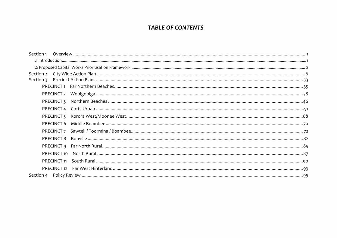
TABLE OF CONTENTS
Section 1 Overview ..................................................................................................................................................................................................1 1.1 Introduction.............................................................................................................................................................................................................................1 1.2 Proposed Capital Works Prioritisation Framework.............................................................................................................................................................. 2
Section 2 City Wide Action Plan..............................................................................................................................................................................6 Section 3 Precinct Action Plans ............................................................................................................................................................................ 33
PRECINCT 1 Far Northern Beaches............................................................................................................................................................. 35 PRECINCT 2 Woolgoolga ............................................................................................................................................................................38 PRECINCT 3 Northern Beaches ..................................................................................................................................................................46 PRECINCT 4 Coffs Urban .............................................................................................................................................................................51 PRECINCT 5 Korora West/Moonee West...................................................................................................................................................68 PRECINCT 6 Middle Boambee....................................................................................................................................................................70 PRECINCT 7 Sawtell / Toormina / Boambee............................................................................................................................................... 72 PRECINCT 8 Bonville ...................................................................................................................................................................................82 PRECINCT 9 Far North Rural.......................................................................................................................................................................85 PRECINCT 10 North Rural ...........................................................................................................................................................................87 PRECINCT 11 South Rural ............................................................................................................................................................................90 PRECINCT 12 Far West Hinterland..............................................................................................................................................................93
Section 4 Policy Review ........................................................................................................................................................................................95
_______________________________________________________________________________________________________________________________________ Open Space Strategy 2010 Page 1
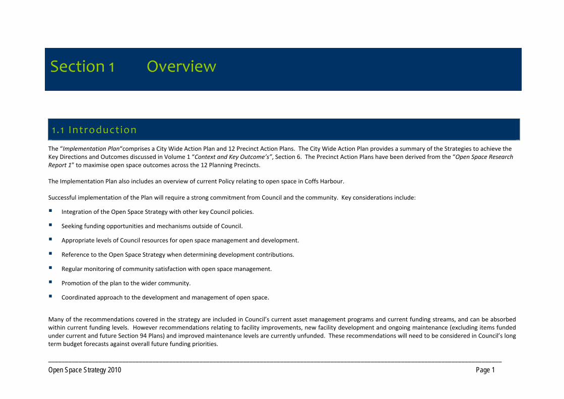
Section 1 Overview
1 .1 Introduction
The “Implementation Plan“comprises a City Wide Action Plan and 12 Precinct Action Plans. The City Wide Action Plan provides a summary of the Strategies to achieve the Key Directions and Outcomes discussed in Volume 1 “Context and Key Outcome’s”, Section 6. The Precinct Action Plans have been derived from the “Open Space Research Report 1” to maximise open space outcomes across the 12 Planning Precincts.
The Implementation Plan also includes an overview of current Policy relating to open space in Coffs Harbour.
Successful implementation of the Plan will require a strong commitment from Council and the community. Key considerations include:
Integration of the Open Space Strategy with other key Council policies.
Seeking funding opportunities and mechanisms outside of Council.
Appropriate levels of Council resources for open space management and development.
Reference to the Open Space Strategy when determining development contributions.
Regular monitoring of community satisfaction with open space management.
Promotion of the plan to the wider community.
Coordinated approach to the development and management of open space.
Many of the recommendations covered in the strategy are included in Council’s current asset management programs and current funding streams, and can be absorbed within current funding levels. However recommendations relating to facility improvements, new facility development and ongoing maintenance (excluding items funded under current and future Section 94 Plans) and improved maintenance levels are currently unfunded. These recommendations will need to be considered in Council’s long term budget forecasts against overall future funding priorities.
Section 1 Overview
_______________________________________________________________________________________________________________________________________ Open Space Strategy 2010 Page 2
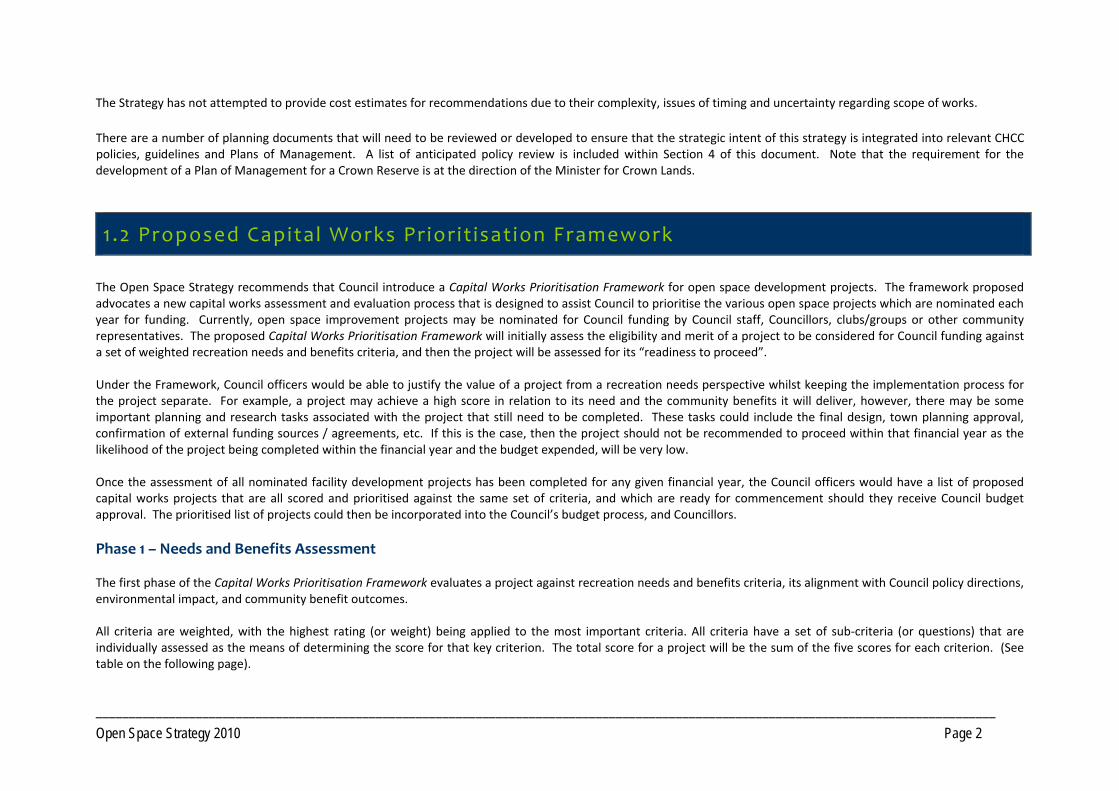
The Strategy has not attempted to provide cost estimates for recommendations due to their complexity, issues of timing and uncertainty regarding scope of works. There are a number of planning documents that will need to be reviewed or developed to ensure that the strategic intent of this strategy is integrated into relevant CHCC policies, guidelines and Plans of Management. A list of anticipated policy review is included within Section 4 of this document. Note that the requirement for the development of a Plan of Management for a Crown Reserve is at the direction of the Minister for Crown Lands.
1 .2 Proposed Capital Works Prior it isat ion Framework The Open Space Strategy recommends that Council introduce a Capital Works Prioritisation Framework for open space development projects. The framework proposed advocates a new capital works assessment and evaluation process that is designed to assist Council to prioritise the various open space projects which are nominated each year for funding. Currently, open space improvement projects may be nominated for Council funding by Council staff, Councillors, clubs/groups or other community representatives. The proposed Capital Works Prioritisation Framework will initially assess the eligibility and merit of a project to be considered for Council funding against a set of weighted recreation needs and benefits criteria, and then the project will be assessed for its “readiness to proceed”. Under the Framework, Council officers would be able to justify the value of a project from a recreation needs perspective whilst keeping the implementation process for the project separate. For example, a project may achieve a high score in relation to its need and the community benefits it will deliver, however, there may be some important planning and research tasks associated with the project that still need to be completed. These tasks could include the final design, town planning approval, confirmation of external funding sources / agreements, etc. If this is the case, then the project should not be recommended to proceed within that financial year as the likelihood of the project being completed within the financial year and the budget expended, will be very low. Once the assessment of all nominated facility development projects has been completed for any given financial year, the Council officers would have a list of proposed capital works projects that are all scored and prioritised against the same set of criteria, and which are ready for commencement should they receive Council budget approval. The prioritised list of projects could then be incorporated into the Council’s budget process, and Councillors. Phase 1 – Needs and Benefits Assessment The first phase of the Capital Works Prioritisation Framework evaluates a project against recreation needs and benefits criteria, its alignment with Council policy directions, environmental impact, and community benefit outcomes. All criteria are weighted, with the highest rating (or weight) being applied to the most important criteria. All criteria have a set of sub‐criteria (or questions) that are individually assessed as the means of determining the score for that key criterion. The total score for a project will be the sum of the five scores for each criterion. (See table on the following page).
_______________________________________________________________________________________________________________________________________ Open Space Strategy 2010 Page 3
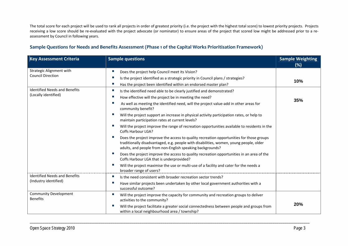
The total score for each project will be used to rank all projects in order of greatest priority (i.e. the project with the highest total score) to lowest priority projects. Projects receiving a low score should be re‐evaluated with the project advocate (or nominator) to ensure areas of the project that scored low might be addressed prior to a re‐assessment by Council in following years. Sample Questions for Needs and Benefits Assessment (Phase 1 of the Capital Works Prioritisation Framework) Key Assessment Criteria Sample questions Sample Weighting
(%) Strategic Alignment with Council Direction
Does the project help Council meet its Vision?
Is the project identified as a strategic priority in Council plans / strategies?
Has the project been identified within an endorsed master plan?
10%
Identified Needs and Benefits (Locally identified)
Is the identified need able to be clearly justified and demonstrated?
How effective will the project be in meeting the need?
As well as meeting the identified need, will the project value‐add in other areas for community benefit?
Will the project support an increase in physical activity participation rates, or help to maintain participation rates at current levels?
Will the project improve the range of recreation opportunities available to residents in the Coffs Harbour LGA?
Does the project improve the access to quality recreation opportunities for those groups traditionally disadvantaged, e.g. people with disabilities, women, young people, older adults, and people from non‐English speaking backgrounds?
Does the project improve the access to quality recreation opportunities in an area of the Coffs Harbour LGA that is underprovided?
Will the project maximise the use or multi‐use of a facility and cater for the needs a broader range of users?
35%
Identified Needs and Benefits (Industry identified)
Is the need consistent with broader recreation sector trends?
Have similar projects been undertaken by other local government authorities with a successful outcome?
Community Development Benefits
Will the project improve the capacity for community and recreation groups to deliver activities to the community?
Will the project facilitate a greater social connectedness between people and groups from within a local neighbourhood area / township?
20%
_______________________________________________________________________________________________________________________________________ Open Space Strategy 2010 Page 4
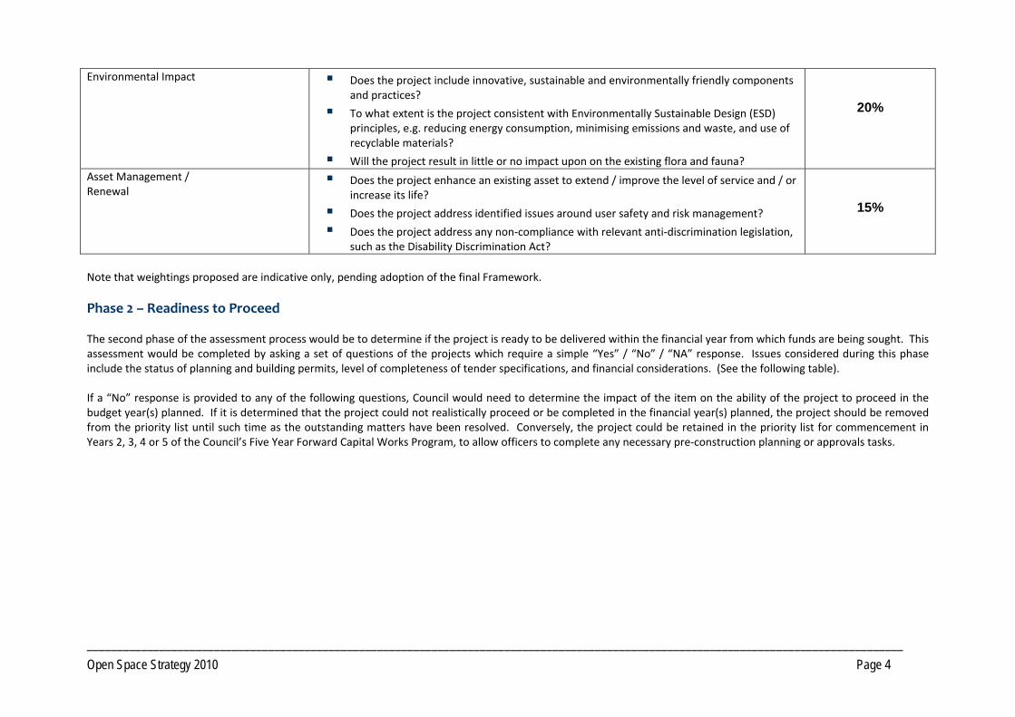
Environmental Impact Does the project include innovative, sustainable and environmentally friendly components and practices?
To what extent is the project consistent with Environmentally Sustainable Design (ESD) principles, e.g. reducing energy consumption, minimising emissions and waste, and use of recyclable materials?
Will the project result in little or no impact upon on the existing flora and fauna?
20%
Asset Management / Renewal
Does the project enhance an existing asset to extend / improve the level of service and / or increase its life?
Does the project address identified issues around user safety and risk management?
Does the project address any non‐compliance with relevant anti‐discrimination legislation, such as the Disability Discrimination Act?
15%
Note that weightings proposed are indicative only, pending adoption of the final Framework. Phase 2 – Readiness to Proceed The second phase of the assessment process would be to determine if the project is ready to be delivered within the financial year from which funds are being sought. This assessment would be completed by asking a set of questions of the projects which require a simple “Yes” / “No” / “NA” response. Issues considered during this phase include the status of planning and building permits, level of completeness of tender specifications, and financial considerations. (See the following table). If a “No” response is provided to any of the following questions, Council would need to determine the impact of the item on the ability of the project to proceed in the budget year(s) planned. If it is determined that the project could not realistically proceed or be completed in the financial year(s) planned, the project should be removed from the priority list until such time as the outstanding matters have been resolved. Conversely, the project could be retained in the priority list for commencement in Years 2, 3, 4 or 5 of the Council’s Five Year Forward Capital Works Program, to allow officers to complete any necessary pre‐construction planning or approvals tasks.
_______________________________________________________________________________________________________________________________________ Open Space Strategy 2010 Page 5
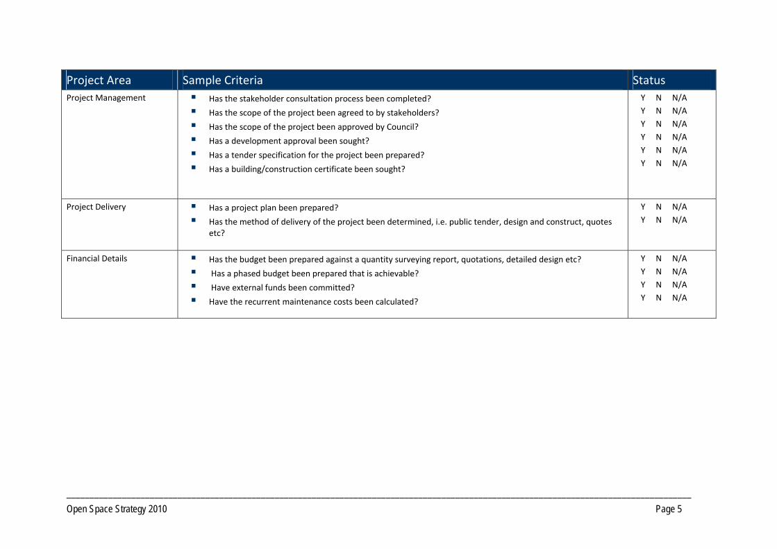
Project Area Sample Criteria Status Project Management Has the stakeholder consultation process been completed?
Has the scope of the project been agreed to by stakeholders?
Has the scope of the project been approved by Council?
Has a development approval been sought?
Has a tender specification for the project been prepared?
Has a building/construction certificate been sought?
Y N N/A Y N N/A Y N N/A Y N N/A Y N N/A Y N N/A
Project Delivery Has a project plan been prepared?
Has the method of delivery of the project been determined, i.e. public tender, design and construct, quotes etc?
Y N N/A Y N N/A
Financial Details Has the budget been prepared against a quantity surveying report, quotations, detailed design etc?
Has a phased budget been prepared that is achievable?
Have external funds been committed?
Have the recurrent maintenance costs been calculated?
Y N N/A Y N N/A Y N N/A Y N N/A
_______________________________________________________________________________________________________________________________________ Open Space Strategy 2010 Page 6
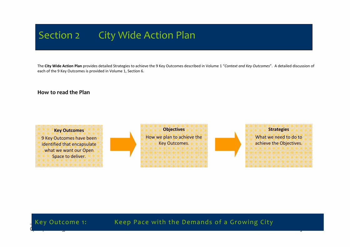
Section 2 City Wide Action Plan The City Wide Action Plan provides detailed Strategies to achieve the 9 Key Outcomes described in Volume 1 “Context and Key Outcomes”. A detailed discussion of each of the 9 Key Outcomes is provided in Volume 1, Section 6.
How to read the Plan
Key Outcome 1 : Keep Pace with the Demands of a Growing City
Section 2 City Wide Action Plan
Key Outcomes
9 Key Outcomes have been identified that encapsulate what we want our Open
Space to deliver.
Objectives
How we plan to achieve the Key Outcomes.
Strategies
What we need to do to achieve the Objectives.
_______________________________________________________________________________________________________________________________________ Open Space Strategy 2010 Page 7
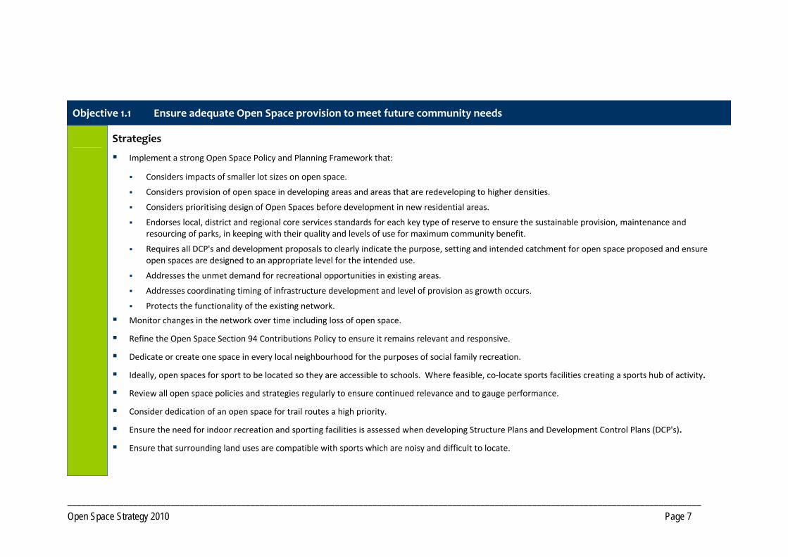
Objective 1.1 Ensure adequate Open Space provision to meet future community needs
Strategies
Implement a strong Open Space Policy and Planning Framework that:
Considers impacts of smaller lot sizes on open space.
Considers provision of open space in developing areas and areas that are redeveloping to higher densities.
Considers prioritising design of Open Spaces before development in new residential areas.
Endorses local, district and regional core services standards for each key type of reserve to ensure the sustainable provision, maintenance and resourcing of parks, in keeping with their quality and levels of use for maximum community benefit.
Requires all DCP's and development proposals to clearly indicate the purpose, setting and intended catchment for open space proposed and ensure open spaces are designed to an appropriate level for the intended use.
Addresses the unmet demand for recreational opportunities in existing areas.
Addresses coordinating timing of infrastructure development and level of provision as growth occurs.
Protects the functionality of the existing network.
Monitor changes in the network over time including loss of open space.
Refine the Open Space Section 94 Contributions Policy to ensure it remains relevant and responsive.
Dedicate or create one space in every local neighbourhood for the purposes of social family recreation.
Ideally, open spaces for sport to be located so they are accessible to schools. Where feasible, co‐locate sports facilities creating a sports hub of activity.
Review all open space policies and strategies regularly to ensure continued relevance and to gauge performance.
Consider dedication of an open space for trail routes a high priority.
Ensure the need for indoor recreation and sporting facilities is assessed when developing Structure Plans and Development Control Plans (DCP's).
Ensure that surrounding land uses are compatible with sports which are noisy and difficult to locate.
_______________________________________________________________________________________________________________________________________ Open Space Strategy 2010 Page 8
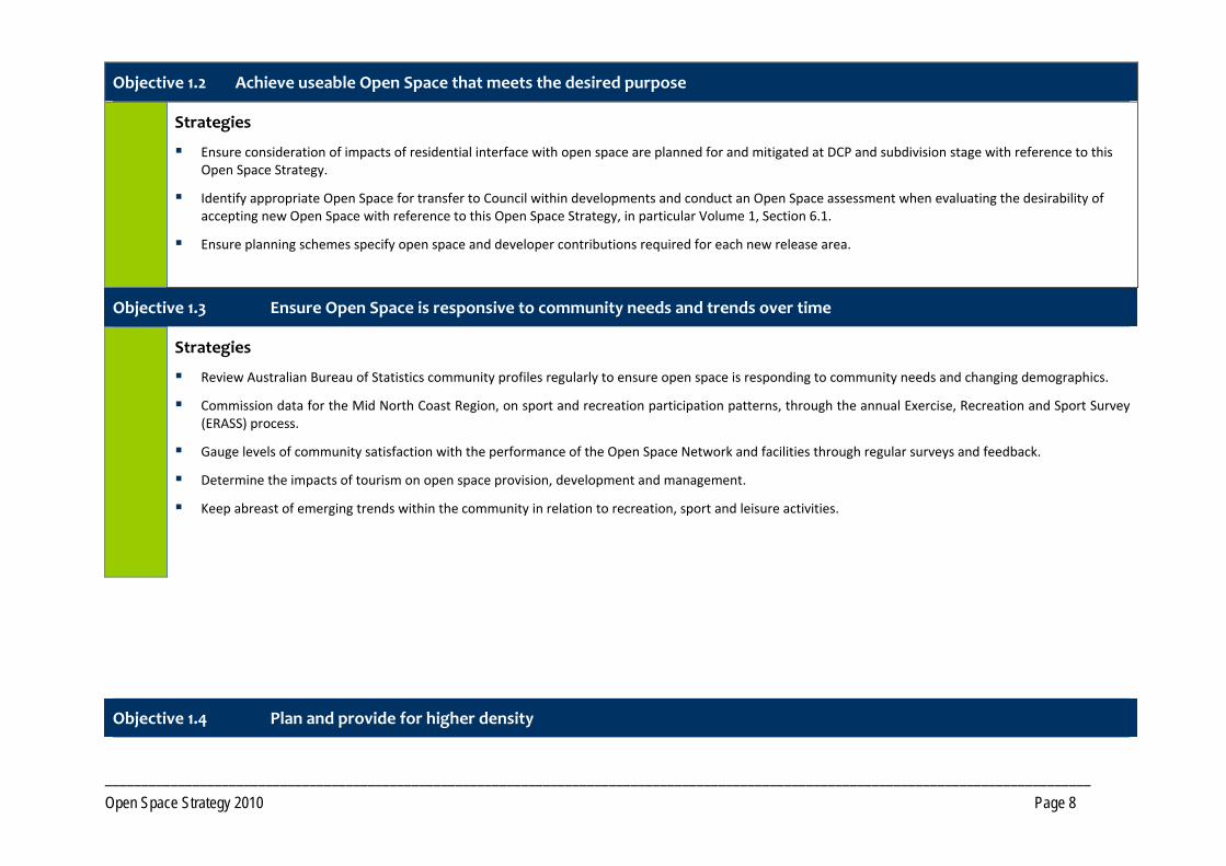
Objective 1.2 Achieve useable Open Space that meets the desired purpose
Strategies
Ensure consideration of impacts of residential interface with open space are planned for and mitigated at DCP and subdivision stage with reference to this Open Space Strategy.
Identify appropriate Open Space for transfer to Council within developments and conduct an Open Space assessment when evaluating the desirability of accepting new Open Space with reference to this Open Space Strategy, in particular Volume 1, Section 6.1.
Ensure planning schemes specify open space and developer contributions required for each new release area.
Objective 1.3 Ensure Open Space is responsive to community needs and trends over time
Strategies
Review Australian Bureau of Statistics community profiles regularly to ensure open space is responding to community needs and changing demographics.
Commission data for the Mid North Coast Region, on sport and recreation participation patterns, through the annual Exercise, Recreation and Sport Survey (ERASS) process.
Gauge levels of community satisfaction with the performance of the Open Space Network and facilities through regular surveys and feedback.
Determine the impacts of tourism on open space provision, development and management.
Keep abreast of emerging trends within the community in relation to recreation, sport and leisure activities.
Objective 1.4 Plan and provide for higher density
_______________________________________________________________________________________________________________________________________ Open Space Strategy 2010 Page 9
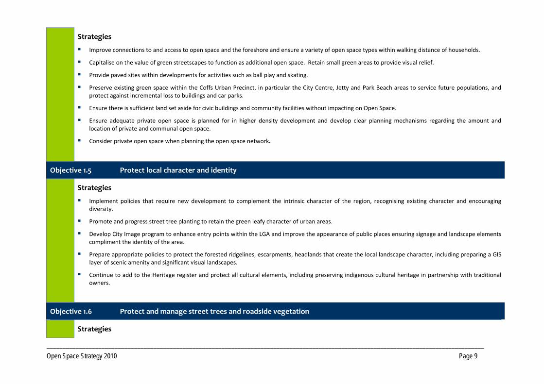
Strategies
Improve connections to and access to open space and the foreshore and ensure a variety of open space types within walking distance of households.
Capitalise on the value of green streetscapes to function as additional open space. Retain small green areas to provide visual relief.
Provide paved sites within developments for activities such as ball play and skating.
Preserve existing green space within the Coffs Urban Precinct, in particular the City Centre, Jetty and Park Beach areas to service future populations, and protect against incremental loss to buildings and car parks.
Ensure there is sufficient land set aside for civic buildings and community facilities without impacting on Open Space.
Ensure adequate private open space is planned for in higher density development and develop clear planning mechanisms regarding the amount and location of private and communal open space.
Consider private open space when planning the open space network.
Objective 1.5 Protect local character and identity
Strategies
Implement policies that require new development to complement the intrinsic character of the region, recognising existing character and encouraging diversity.
Promote and progress street tree planting to retain the green leafy character of urban areas.
Develop City Image program to enhance entry points within the LGA and improve the appearance of public places ensuring signage and landscape elements compliment the identity of the area.
Prepare appropriate policies to protect the forested ridgelines, escarpments, headlands that create the local landscape character, including preparing a GIS layer of scenic amenity and significant visual landscapes.
Continue to add to the Heritage register and protect all cultural elements, including preserving indigenous cultural heritage in partnership with traditional owners.
Objective 1.6 Protect and manage street trees and roadside vegetation
Strategies
_______________________________________________________________________________________________________________________________________ Open Space Strategy 2010 Page 10
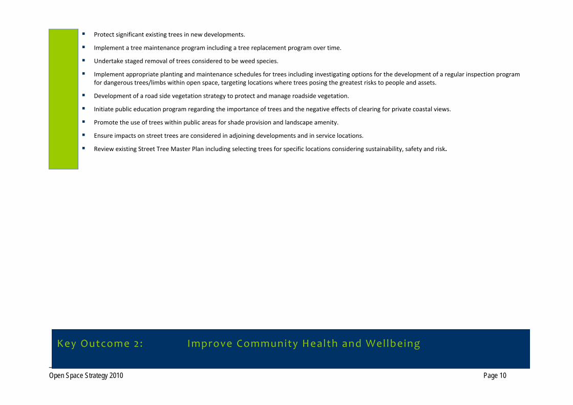
Protect significant existing trees in new developments.
Implement a tree maintenance program including a tree replacement program over time.
Undertake staged removal of trees considered to be weed species.
Implement appropriate planting and maintenance schedules for trees including investigating options for the development of a regular inspection program for dangerous trees/limbs within open space, targeting locations where trees posing the greatest risks to people and assets.
Development of a road side vegetation strategy to protect and manage roadside vegetation.
Initiate public education program regarding the importance of trees and the negative effects of clearing for private coastal views.
Promote the use of trees within public areas for shade provision and landscape amenity.
Ensure impacts on street trees are considered in adjoining developments and in service locations.
Review existing Street Tree Master Plan including selecting trees for specific locations considering sustainability, safety and risk.
Key Outcome 2: Improve Community Health and Wellbeing
_______________________________________________________________________________________________________________________________________ Open Space Strategy 2010 Page 11
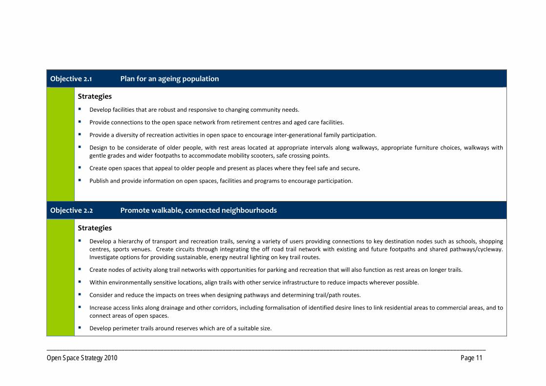
Objective 2.1 Plan for an ageing population
Strategies
Develop facilities that are robust and responsive to changing community needs.
Provide connections to the open space network from retirement centres and aged care facilities.
Provide a diversity of recreation activities in open space to encourage inter‐generational family participation.
Design to be considerate of older people, with rest areas located at appropriate intervals along walkways, appropriate furniture choices, walkways with gentle grades and wider footpaths to accommodate mobility scooters, safe crossing points.
Create open spaces that appeal to older people and present as places where they feel safe and secure.
Publish and provide information on open spaces, facilities and programs to encourage participation.
Objective 2.2 Promote walkable, connected neighbourhoods
Strategies
Develop a hierarchy of transport and recreation trails, serving a variety of users providing connections to key destination nodes such as schools, shopping centres, sports venues. Create circuits through integrating the off road trail network with existing and future footpaths and shared pathways/cycleway. Investigate options for providing sustainable, energy neutral lighting on key trail routes.
Create nodes of activity along trail networks with opportunities for parking and recreation that will also function as rest areas on longer trails.
Within environmentally sensitive locations, align trails with other service infrastructure to reduce impacts wherever possible.
Consider and reduce the impacts on trees when designing pathways and determining trail/path routes.
Increase access links along drainage and other corridors, including formalisation of identified desire lines to link residential areas to commercial areas, and to connect areas of open spaces.
Develop perimeter trails around reserves which are of a suitable size.
_______________________________________________________________________________________________________________________________________ Open Space Strategy 2010 Page 12
Support the development of best practice planning guidelines to ensure permeability of future subdivisions to facilitate walking and cycling. Guidelines also need to address creating pedestrian‐friendly streetscapes, with adequate shade, pathways, separation from traffic.
Develop a Shade Policy and implement a Shade Program, using appropriate native species, along major routes throughout the City.
Provide appropriate signage along trails including directional, distance and wayfarer signs.
Ensure paths and trails are maintained to an appropriate standard consistent with level and type of use.
Prioritise funding for walkway and cycleway infrastructure projects including continued development of the Coastal Cycleway, seeking funding opportunities from State Government.
Prepare a ‘Tracks, Trails and Cycleway’ brochure linked to Council’s website and distributed throughout the City.
Review the Solitary Islands Coastal Walk strategy and continue development of the coastal walk.
Objective 2.3 Create Regional Trail Corridors to service residents and visitors
Strategies
Investigate feasibility of a Regional trails network, utilising unformed Crown Roads, Travelling Stock Routes fire trails, State Forest and National Park estate and private property agreements to create a network of longer trails suitable for hiking, horse riding and mountain biking.
As a high priority, work with the Land & Property Management Authority (LPMA) to identify key Crown Roads and Travelling Stock Routes for retention by LPMA.
In partnership with LPMA, State Forests, National Parks and Wildlife Service (NPWS) and relevant private land owners, develop a Regional Trail Strategy to assess options for development, funding, marketing, management and maintenance of a Regional Trail Network.
Work with surrounding LGAs and other government agencies to map existing trails, using agreed standard nomenclature and descriptions for trail types.
Objective 2.4 Develop trail networks within rural residential areas
Strategies
Ensure planning for rural residential areas provides for off‐road trails incorporating elements within this Strategy.
_______________________________________________________________________________________________________________________________________ Open Space Strategy 2010 Page 13
Objective 2.5 Promote programs to encourage physical activity
Strategies
Investigate Council providing programmed activity in parks and seek interest from the private sector in program provision.
Develop a range of promotional material, using different media, regarding opportunities for physical activity within the Open Space Network.
Objective 2.6 Provide a network of facilities that support physical activity
Strategies
Continue to provide a diverse range of opportunities in both land based and aquatic settings to be physically active.
Support upgrades to Council managed aquatic infrastructure throughout the LGA. Progress planned upgrades to the Coffs Harbour War Memorial Pool to reinforce its position as a facility of Regional significance. Long term undertake a strategic review of aquatic needs within the LGA.
Consider developing fitness circuits along key trails. Consider creating linked fitness trails through establishing fitness equipment in small parks.
Protect outdoor recreation opportunities and work with State agencies to ensure ongoing provision. In particular advocate for an ongoing allocation of land for Mountain Biking within the State Forest system.
In conjunction with relevant providers, compile an inventory of outdoor recreation activities in Coffs Harbour and make available to the public.
Continue to provide and maintain open space and infrastructure for sport, in conjunction with Clubs, Associations and Community Management Committees.
_______________________________________________________________________________________________________________________________________ Open Space Strategy 2010 Page 14
Objective 3.1 Provide a range of opportunities for Social and Family recreation
Strategies
Redevelop key locations with an improved range of facilities and opportunities along the foreshores to cater for large gatherings and tourist influx. In particular, Jetty Foreshores, Lower Park Beach including Pet Porpoise Pool Park, Diggers Beach and Woolgoolga Beach Reserve.
Continue to develop Brelsford Park to function as a City Park incorporating elements such as a cultural precinct, walkways, Village Green and mixed age play facilities.
Upgrade existing spaces that are under capacity, with improved recreation facilities, or acquire land for local social and family recreation in under‐served areas.
Cease to develop playgrounds in “pocket parks” and instead incorporate into larger social family spaces with wider appeal.
Aim to provide a social family park within 500m of households in new developments.
Provide an adequate level of Open Space for social and family recreation that includes play opportunity.
Increase funding levels for play and recreation facilities.
Increase the number of social family spaces through converting play spaces and undeveloped land that are of sufficient size to a social family function through park redesign and provision of additional/improved facilities. Once Council has developed the key spaces, small non‐viable play spaces can be reallocated as to other functions such as relaxation contemplation or amenity parkland.
Provide diversity of experience in existing small parks by creating a different experience in each park.
Key Outcome 3 : Provide for Social and Family Recreation
_______________________________________________________________________________________________________________________________________ Open Space Strategy 2010 Page 15
Objective 3.2 Provide additional opportunities for Youth
Strategies
Provide facilities for organised sports.
Engage young people in the design development and management of youth oriented open space and facilities.
Provide opportunities in each Precinct for young people, especially females, to be active and to just “hang out” in safe observable spaces.
Investigate opportunities to provide multi‐purpose outdoor facilities, eg BMX tracks, in appropriate locations within each precinct. In villages, provide in conjunction with other facilities, creating a community hub of activity.
Investigate re‐development of existing facilities, such as the town pool and skate parks, for improved opportunity for physical activity and social interaction.
Provide opportunities for recreation through facilitating/providing events and activities, investigating opportunities to establish performance spaces.
Development of a new Regional Skate Park, serving intermediate and advanced levels.
Consider installation of lighting, to the appropriate Australian Standard for recreational use, at skate parks.
Support rural communities through provision of technical advice and assistance, to develop facilities for youth.
Work with developers and shopping centres to provide Open Space opportunities that are of interest to young people.
Objective 3.3 Provide quality play experiences for children
Strategies
Provide a variety of play equipment, experiences and settings across the Open Space Network, encompassing the design principles discussed in Volume 1.
Instigate Shade Program at play spaces and prioritise sites. All new play spaces to include shade and retrofit priority existing spaces.
Install fencing at play spaces located near collector roads or roads carrying high traffic volumes.
Develop a Regional level playground in conjunction with social family recreation space at the Jetty Foreshores containing a number of activity spaces catering for a wide range of ages.
Develop Playground Strategy for Coffs Harbour to address provision and maintenance.
Investigate removal of play spaces containing only basic play equipment, with limited opportunity for improvement, where play needs are serviced by other spaces.
Upgrade play equipment at play spaces servicing a local (500m) catchment where no opportunity to create local social/family recreation space exists.
_______________________________________________________________________________________________________________________________________ Open Space Strategy 2010 Page 16
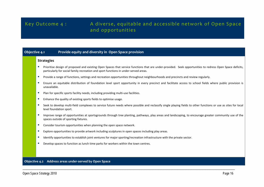
Objective 4.1 Provide equity and diversity in Open Space provision
Strategies
Prioritise design of proposed and existing Open Spaces that service functions that are under‐provided. Seek opportunities to redress Open Space deficits, particularly for social family recreation and sport functions in under‐served areas.
Provide a range of functions, settings and recreation opportunities throughout neighbourhoods and precincts and review regularly.
Ensure an equitable distribution of foundation level sport opportunity in every precinct and facilitate access to school fields where public provision is unavailable.
Plan for specific sports facility needs, including providing multi‐use facilities.
Enhance the quality of existing sports fields to optimise usage.
Seek to develop multi‐field complexes to service future needs where possible and reclassify single playing fields to other functions or use as sites for local level foundation sport.
Improve range of opportunities at sportsgrounds through tree planting, pathways, play areas and landscaping, to encourage greater community use of the spaces outside of sporting fixtures.
Consider tourism opportunities when planning the open space network.
Explore opportunities to provide artwork including sculptures in open spaces including play areas.
Identify opportunities to establish joint ventures for major sporting/recreation infrastructure with the private sector.
Develop spaces to function as lunch time parks for workers within the town centres.
Objective 4.2 Address areas under‐served by Open Space
Key Outcome 4 : A diverse, equitable and accessible network of Open Space and opportunit ies
_______________________________________________________________________________________________________________________________________ Open Space Strategy 2010 Page 17
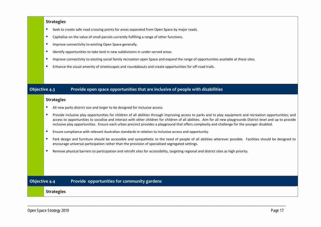
Strategies
Seek to create safe road crossing points for areas separated from Open Space by major roads.
Capitalise on the value of small parcels currently fulfilling a range of other functions.
Improve connectivity to existing Open Space generally.
Identify opportunities to take land in new subdivisions in under‐served areas.
Improve connectivity to existing social family recreation open Space and expand the range of opportunities available at these sites.
Enhance the visual amenity of streetscapes and roundabouts and create opportunities for off‐road trails.
Objective 4.3 Provide open space opportunities that are inclusive of people with disabilities
Strategies
All new parks district size and larger to be designed for inclusive access.
Provide inclusive play opportunities for children of all abilities through improving access to parks and to play equipment and recreation opportunities; and access to opportunities to socialise and interact with other children for children of all abilities. Aim for all new playgrounds District level and up to provide inclusive play opportunities. Ensure each urban precinct provides a playground that offers complexity and challenge for the younger disabled.
Ensure compliance with relevant Australian standards in relation to inclusive access and opportunity.
Park design and furniture should be accessible and sympathetic to the need of people of all abilities wherever possible. Facilities should be designed to encourage universal participation rather than the provision of specialised segregated settings.
Remove physical barriers to participation and retrofit sites for accessibility, targeting regional and district sites as high priority.
Objective 4.4 Provide opportunities for community gardens
Strategies
_______________________________________________________________________________________________________________________________________ Open Space Strategy 2010 Page 18
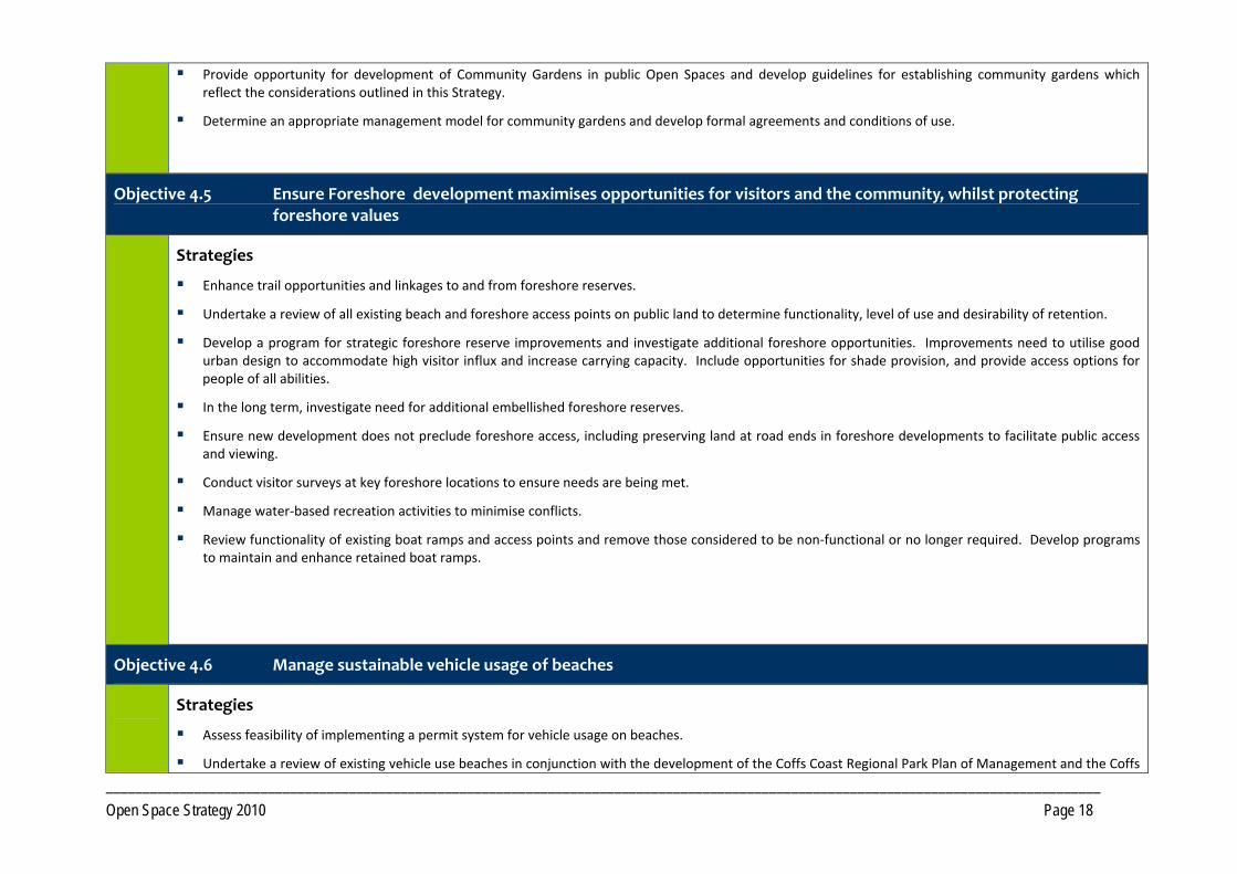
Provide opportunity for development of Community Gardens in public Open Spaces and develop guidelines for establishing community gardens which reflect the considerations outlined in this Strategy.
Determine an appropriate management model for community gardens and develop formal agreements and conditions of use.
Objective 4.5 Ensure Foreshore development maximises opportunities for visitors and the community, whilst protecting foreshore values
Strategies
Enhance trail opportunities and linkages to and from foreshore reserves.
Undertake a review of all existing beach and foreshore access points on public land to determine functionality, level of use and desirability of retention.
Develop a program for strategic foreshore reserve improvements and investigate additional foreshore opportunities. Improvements need to utilise good urban design to accommodate high visitor influx and increase carrying capacity. Include opportunities for shade provision, and provide access options for people of all abilities.
In the long term, investigate need for additional embellished foreshore reserves.
Ensure new development does not preclude foreshore access, including preserving land at road ends in foreshore developments to facilitate public access and viewing.
Conduct visitor surveys at key foreshore locations to ensure needs are being met.
Manage water‐based recreation activities to minimise conflicts.
Review functionality of existing boat ramps and access points and remove those considered to be non‐functional or no longer required. Develop programs to maintain and enhance retained boat ramps.
Objective 4.6 Manage sustainable vehicle usage of beaches
Strategies
Assess feasibility of implementing a permit system for vehicle usage on beaches.
Undertake a review of existing vehicle use beaches in conjunction with the development of the Coffs Coast Regional Park Plan of Management and the Coffs
_______________________________________________________________________________________________________________________________________ Open Space Strategy 2010 Page 19
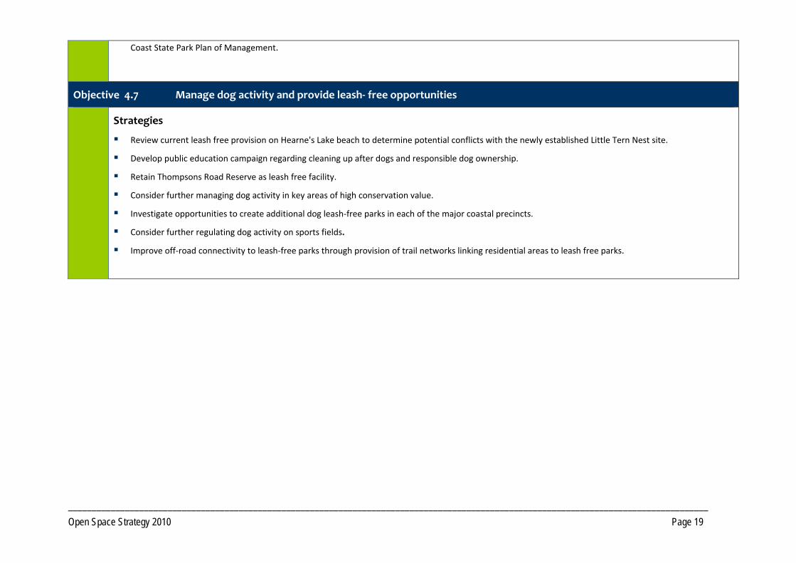
Coast State Park Plan of Management.
Objective 4.7 Manage dog activity and provide leash‐ free opportunities
Strategies
Review current leash free provision on Hearne's Lake beach to determine potential conflicts with the newly established Little Tern Nest site.
Develop public education campaign regarding cleaning up after dogs and responsible dog ownership.
Retain Thompsons Road Reserve as leash free facility.
Consider further managing dog activity in key areas of high conservation value.
Investigate opportunities to create additional dog leash‐free parks in each of the major coastal precincts.
Consider further regulating dog activity on sports fields.
Improve off‐road connectivity to leash‐free parks through provision of trail networks linking residential areas to leash free parks.
_______________________________________________________________________________________________________________________________________ Open Space Strategy 2010 Page 20
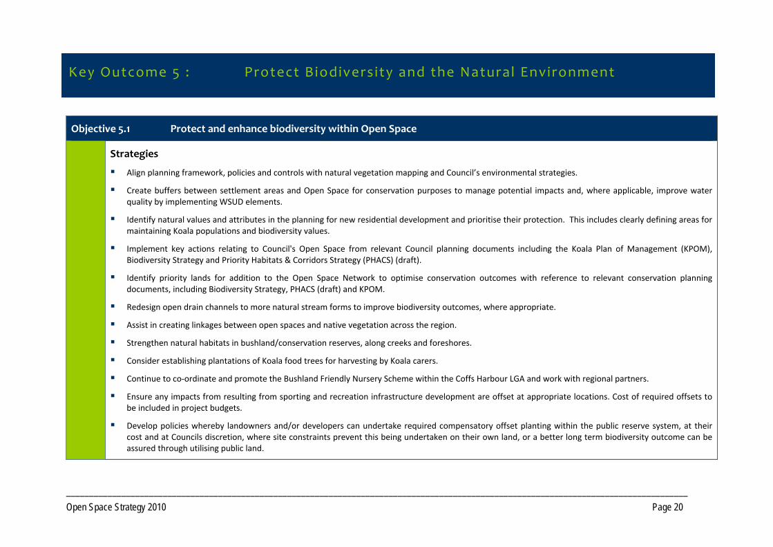
Objective 5.1 Protect and enhance biodiversity within Open Space
Strategies
Align planning framework, policies and controls with natural vegetation mapping and Council’s environmental strategies.
Create buffers between settlement areas and Open Space for conservation purposes to manage potential impacts and, where applicable, improve water quality by implementing WSUD elements.
Identify natural values and attributes in the planning for new residential development and prioritise their protection. This includes clearly defining areas for maintaining Koala populations and biodiversity values.
Implement key actions relating to Council's Open Space from relevant Council planning documents including the Koala Plan of Management (KPOM), Biodiversity Strategy and Priority Habitats & Corridors Strategy (PHACS) (draft).
Identify priority lands for addition to the Open Space Network to optimise conservation outcomes with reference to relevant conservation planning documents, including Biodiversity Strategy, PHACS (draft) and KPOM.
Redesign open drain channels to more natural stream forms to improve biodiversity outcomes, where appropriate.
Assist in creating linkages between open spaces and native vegetation across the region.
Strengthen natural habitats in bushland/conservation reserves, along creeks and foreshores.
Consider establishing plantations of Koala food trees for harvesting by Koala carers.
Continue to co‐ordinate and promote the Bushland Friendly Nursery Scheme within the Coffs Harbour LGA and work with regional partners.
Ensure any impacts from resulting from sporting and recreation infrastructure development are offset at appropriate locations. Cost of required offsets to be included in project budgets.
Develop policies whereby landowners and/or developers can undertake required compensatory offset planting within the public reserve system, at their cost and at Councils discretion, where site constraints prevent this being undertaken on their own land, or a better long term biodiversity outcome can be assured through utilising public land.
Key Outcome 5 : Protect Biodiversity and the Natural Environment
_______________________________________________________________________________________________________________________________________ Open Space Strategy 2010 Page 21
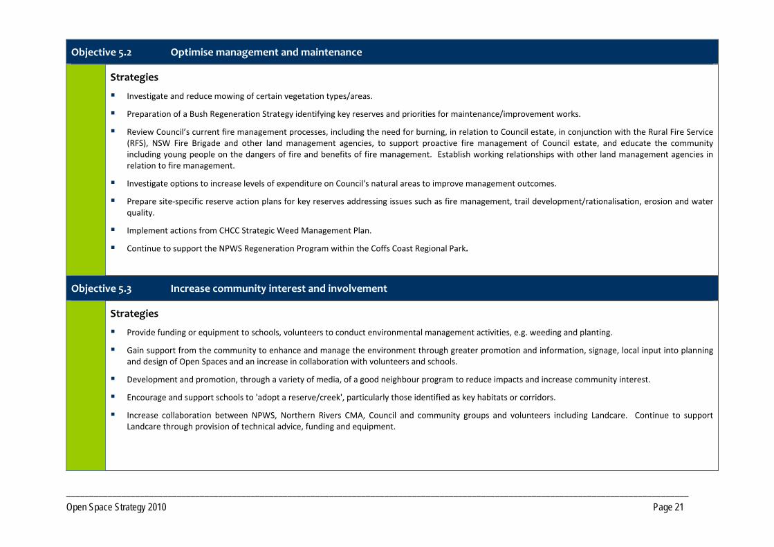
Objective 5.2 Optimise management and maintenance
Strategies
Investigate and reduce mowing of certain vegetation types/areas.
Preparation of a Bush Regeneration Strategy identifying key reserves and priorities for maintenance/improvement works.
Review Council’s current fire management processes, including the need for burning, in relation to Council estate, in conjunction with the Rural Fire Service (RFS), NSW Fire Brigade and other land management agencies, to support proactive fire management of Council estate, and educate the community including young people on the dangers of fire and benefits of fire management. Establish working relationships with other land management agencies in relation to fire management.
Investigate options to increase levels of expenditure on Council's natural areas to improve management outcomes.
Prepare site‐specific reserve action plans for key reserves addressing issues such as fire management, trail development/rationalisation, erosion and water quality.
Implement actions from CHCC Strategic Weed Management Plan.
Continue to support the NPWS Regeneration Program within the Coffs Coast Regional Park.
Objective 5.3 Increase community interest and involvement
Strategies
Provide funding or equipment to schools, volunteers to conduct environmental management activities, e.g. weeding and planting.
Gain support from the community to enhance and manage the environment through greater promotion and information, signage, local input into planning and design of Open Spaces and an increase in collaboration with volunteers and schools.
Development and promotion, through a variety of media, of a good neighbour program to reduce impacts and increase community interest.
Encourage and support schools to 'adopt a reserve/creek', particularly those identified as key habitats or corridors.
Increase collaboration between NPWS, Northern Rivers CMA, Council and community groups and volunteers including Landcare. Continue to support Landcare through provision of technical advice, funding and equipment.

_______________________________________________________________________________________________________________________________________ Open Space Strategy 2010 Page 22
Objective 6.1 Sustainable resourcing, asset development and management
Strategies
Introduce a whole of life asset costing process/system for park assets that :
Details maintenance and capital funding requirements for all public Open Space assets.
Aligns expenditure with short and long term strategic directions of Council.
Captures the key activities and new initiatives to be undertaken.
Identifies the inputs, approved resources and targeted outcomes to be achieved.
Identifies and records whole of life costs.
Reports performance, including financial on each type of Open Space as well as individual reserves.
Review funding processes and allocations for the various Open Space programs and consider increasing funding for Council's Open Space management programs including design, planning, reserve development and maintenance.
Develop asset maintenance plans for all classes of park assets.
Work with the community to develop sustainable Open Space projects that add value to the network.
Develop mechanisms to measure the performance of Open Space including community surveys.
Create and implement a Park Improvement Program based on priorities identified within this Strategy. Investigate options for funding.
Develop programs for asset replacement and renewal including trees. Any drainage works should consider incorporating Water Sensitive Urban Design (WSUD) treatments.
Reduce mowing areas through natural and assisted regeneration where appropriate.
Continue to utilise maintenance agreements with developers for park assets associated with subdivisions.
Key Outcome 6 : Provide Sustainable and Cost EffectiveOpen Space Management
_______________________________________________________________________________________________________________________________________ Open Space Strategy 2010 Page 23
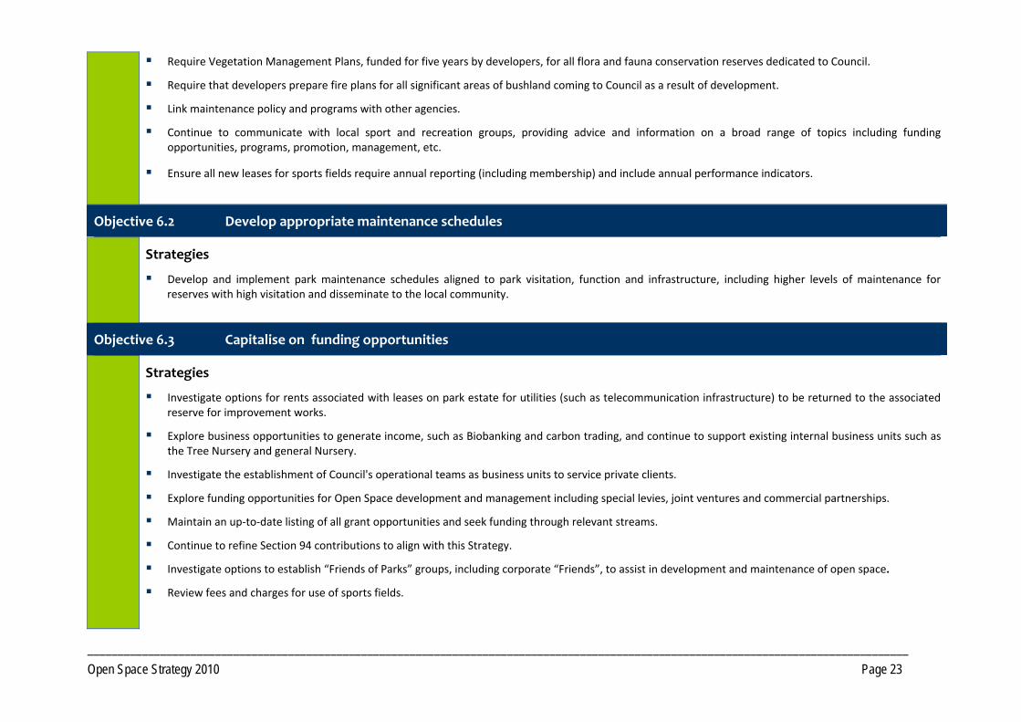
Require Vegetation Management Plans, funded for five years by developers, for all flora and fauna conservation reserves dedicated to Council.
Require that developers prepare fire plans for all significant areas of bushland coming to Council as a result of development.
Link maintenance policy and programs with other agencies.
Continue to communicate with local sport and recreation groups, providing advice and information on a broad range of topics including funding opportunities, programs, promotion, management, etc.
Ensure all new leases for sports fields require annual reporting (including membership) and include annual performance indicators.
Objective 6.2 Develop appropriate maintenance schedules
Strategies
Develop and implement park maintenance schedules aligned to park visitation, function and infrastructure, including higher levels of maintenance for reserves with high visitation and disseminate to the local community.
Objective 6.3 Capitalise on funding opportunities
Strategies
Investigate options for rents associated with leases on park estate for utilities (such as telecommunication infrastructure) to be returned to the associated reserve for improvement works.
Explore business opportunities to generate income, such as Biobanking and carbon trading, and continue to support existing internal business units such as the Tree Nursery and general Nursery.
Investigate the establishment of Council's operational teams as business units to service private clients.
Explore funding opportunities for Open Space development and management including special levies, joint ventures and commercial partnerships.
Maintain an up‐to‐date listing of all grant opportunities and seek funding through relevant streams.
Continue to refine Section 94 contributions to align with this Strategy.
Investigate options to establish “Friends of Parks” groups, including corporate “Friends”, to assist in development and maintenance of open space.
Review fees and charges for use of sports fields.
_______________________________________________________________________________________________________________________________________ Open Space Strategy 2010 Page 24
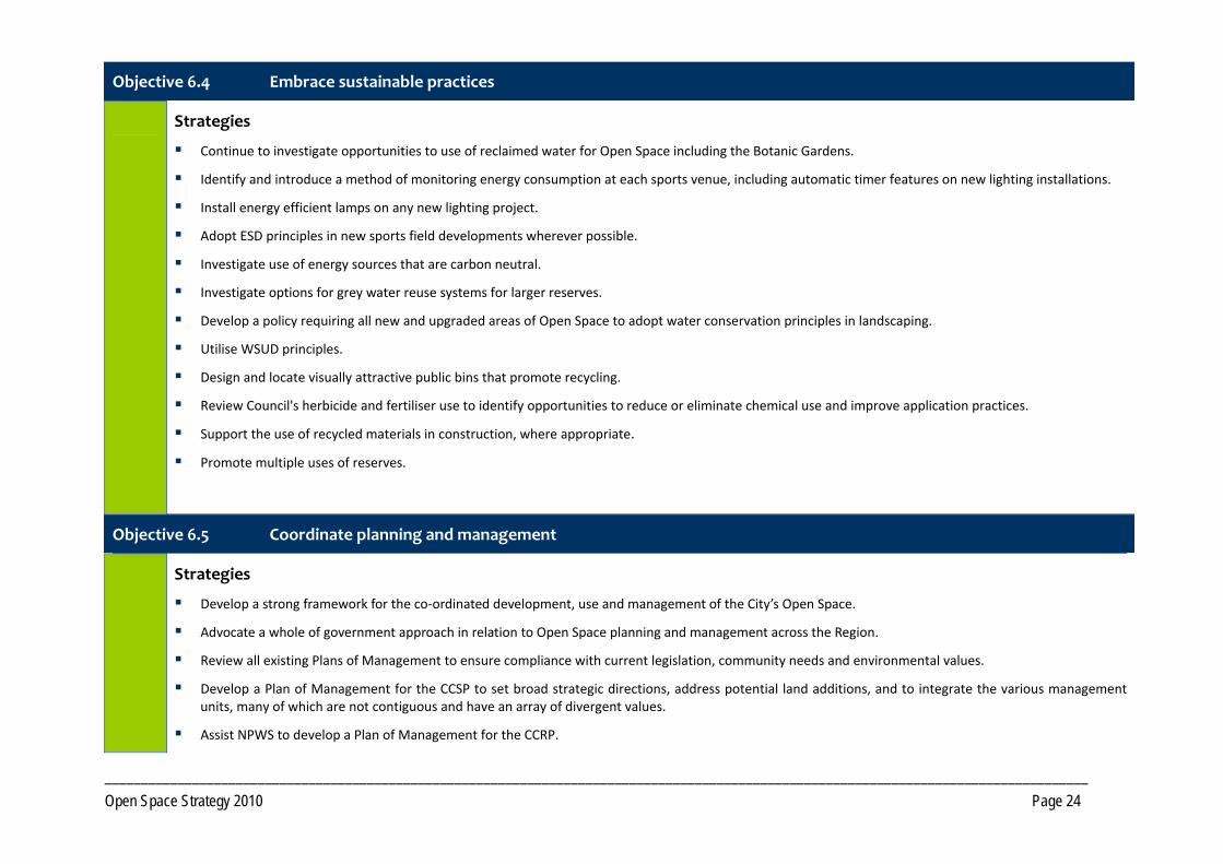
Objective 6.4 Embrace sustainable practices
Strategies
Continue to investigate opportunities to use of reclaimed water for Open Space including the Botanic Gardens.
Identify and introduce a method of monitoring energy consumption at each sports venue, including automatic timer features on new lighting installations.
Install energy efficient lamps on any new lighting project.
Adopt ESD principles in new sports field developments wherever possible.
Investigate use of energy sources that are carbon neutral.
Investigate options for grey water reuse systems for larger reserves.
Develop a policy requiring all new and upgraded areas of Open Space to adopt water conservation principles in landscaping.
Utilise WSUD principles.
Design and locate visually attractive public bins that promote recycling.
Review Council's herbicide and fertiliser use to identify opportunities to reduce or eliminate chemical use and improve application practices.
Support the use of recycled materials in construction, where appropriate.
Promote multiple uses of reserves.
Objective 6.5 Coordinate planning and management
Strategies
Develop a strong framework for the co‐ordinated development, use and management of the City’s Open Space.
Advocate a whole of government approach in relation to Open Space planning and management across the Region.
Review all existing Plans of Management to ensure compliance with current legislation, community needs and environmental values.
Develop a Plan of Management for the CCSP to set broad strategic directions, address potential land additions, and to integrate the various management units, many of which are not contiguous and have an array of divergent values.
Assist NPWS to develop a Plan of Management for the CCRP.
_______________________________________________________________________________________________________________________________________ Open Space Strategy 2010 Page 25
Implement a program of Master Plans and Site Plans that will guide the development/redevelopment of Open Space.
Adopt a whole of park approach when designing facilities.
Rezone private land, currently zoned 6A, which is no longer required for Open Space purposes.
Review current Classification of Council’s Public Reserves.
Objective 6.6 Develop design standards that are innovative, and promote safety and inclusive access
Strategies
Develop innovative and contemporary inclusive design standards for park facilities including infrastructure, furniture, pathways, signage, landscaping themed for different settings e.g. coastal and hinterland areas.
Develop signage policy for Open Space and urban areas.
Continue to include principles of Crime Prevention Through Environmental Design (CPTED) for new Open Space development.
Objective 6.7 Addressing risk management and safety
Strategies
Ensure age‐appropriate challenges are provided within Open Space and maintain the balance between providing challenge and managing unacceptable risk.
Ensure that facilities and activity nodes are designed to reduce risks, especially in relation to the co‐location of incompatible activities involving children.
Undertake hazard inspections of all park assets and maintain up to date records. Ensure timely rectification of defects.
Investigate a pro‐active program of tree inspections, particularly over heavily used spaces and facilities.
Continue to implement regular maintenance programs and align with degree of infrastructure and visitation levels.
_______________________________________________________________________________________________________________________________________ Open Space Strategy 2010 Page 26
Objective 6.8 Address anti social behaviour
Strategies
Investigate options for providing lighting at key reserves, especially along main trail routes.
Co‐locate activity nodes within open space to maximise surveillance.
Encourage community involvement and a sense of ownership of Open Space by neighbours.
Ensure open spaces are well maintained and that damage and vandalism is quickly repaired/mitigated.
Continue to utilise alcohol prohibitions within Open Space at locations where appropriate.
Objective 6.9 Manage community events and festivals
Strategies
Continue to support community events and festivals in Open Space, at a scale and frequency that does not negatively impact on other users.
Continue to support commercial events and private functions provided they do not compromise the use and enjoyment of the Open Space by other users.
Develop guidelines to assess suitability of commercial events and private functions and establish protocols for restoration of areas by event organisers post event.
Objective 6.10 Identify opportunities to add to the Open Space network
Strategies
Ensure future planning processes include the dedication of sufficient land to meet future open space needs.
Explore mechanisms for the acquisition of priority Open Space. Where parcels cannot be acquired through development processes or through Section 94 funds, alternate acquisition mechanisms, including funding, need to be investigated.
Achieve integrated management through rationalisation of reserve management where possible. Initiate discussions with LPMA for transfer of additional Crown holdings to the Coffs Coast State Park (CCSP). Progress planned Stage 2 additions of Council land to the CCRP. Continue to support consultative process between LPMA and NPWS regarding additional strategic Crown land divestments to CCRP.
_______________________________________________________________________________________________________________________________________ Open Space Strategy 2010 Page 27
Objective 6.11 Disposal of surplus Open Space
Strategies
Consider the sale of land surplus to Open Space requirements with funds generated being used for reserve improvements or for acquisition of more suitable Open Space in the neighbourhood.
Consider the following community reinvestment principles in relation to disposal:
All Funds from sale of Council owned open space to be used to improve open space opportunities within the local area of the subject land.
Explore opportunities with LPMA of funds from sale of Crown lands back to the local area of the subject land.
Involve the community when significant changes are planned.
_______________________________________________________________________________________________________________________________________ Open Space Strategy 2010 Page 28
Objective 7.1 Promote partnerships with State Government and the commercial sector to maximise use of current resources
Strategies
Continue to support partnership with NPWS for management of the Coffs Coast Regional Park.
Continue to support partnership with LPMA for management of the Coffs Coast State Park and the Crown Reserve system.
Explore opportunities with NSW State Forests for greater community use of State Forests for outdoor recreation activities.
Promote partnerships with other land management agencies to ensure Open Space not under Council control is included in planning and to ensure an ongoing supply of land suitable for outdoor recreation activities.
Seek sponsorship from commercial sector for reserve improvements.
Objective 7.2 Establish partnerships with schools for public use of school facilities
Strategies
Investigate opportunities for schools to fill gaps identified in the distribution of some open space functions such as sport, play and community horticulture.
Explore partnerships opportunities for shared provision of facilities such as Indoor sports venues and fields.
Identify opportunities to establish joint ventures for major sporting/recreation infrastructure with Schools/universities as required.
Work closely with schools to meet community and school objectives, such as enhanced physical activity and biodiversity, and encouraging children to walk and cycle to school safely.
Key Outcome 7 : Promote Partnerships and Community Engagement
_______________________________________________________________________________________________________________________________________ Open Space Strategy 2010 Page 29
Objective 7.3 Ensure community involvement in the planning and management of Open Space
Strategies
Involve the community and relevant stakeholders at an early stage in new Open Space planning and design initiatives including on site forums and questionnaires.
Continue to support a consultation process that fosters community engagement and ensure Open Space development and management are inclusive of the community’s ideas.
Continue to support and promote community groups such as Landcare, Reserve Trusts and Community Management Committees.
Explore opportunities with Service Organisations, for park based projects, developing stewardship of local Parks.
Establish “Friends of Park” program to involve the community, and commercial operators, in park development and maintenance.
Review policy for naming of Parks and Park infrastructure, including provision of plaques, and address corporate sponsorship/badging.
Objective 7.4 Develop a range of information material to promote the Open Space network to the community
Strategies
Provide information through a range of media that targets specific demographics and areas of interest on Open Space opportunities including:
Preparation of a Parks Information Brochure to promote key Parks and facilities.
Updating Council’s website to include more information on Open Space opportunities.
_______________________________________________________________________________________________________________________________________ Open Space Strategy 2010 Page 30
Objective 8.1 Consider the impacts of climate on Open Space planning, design and management
Strategies
Take account of current risk assessment strategies and identify areas of high risk where mitigation of saltwater intrusion could be feasible.
Develop strategies to address the potential loss of key foreshore reserves and associated infrastructure, including caravan parks, which are a significant economic driver of the Crown Reserve system.
Build provisions into planning documents for future Open Spaces outside of sea‐level rise affected areas.
Planning for recreational facilities above sea‐level rise predictions e.g. boardwalks.
Cost vs. likely life of asset (in relation to predicted sea level rise) analysis in relation to new major recreation and sporting infrastructure.
Changes towards more heat and drought resilient species of plants in parks and grass species on playing fields.
Assess need for increased budgets to cover likely creased maintenance costs. Provide for increased regular maintenance of park/green space in Council management plans.
Assess Open Space drainage system and improve to cope with predicted rain events.
Develop and implement a pest, weed and invasive species management policy/strategy that takes into account changed climatic conditions (many local government areas have management policies/ strategies in place). Consideration to be given to:
Promote awareness to local communities of potential weed risks resulting from climate change in the local area (incorporate into existing awareness programmes if appropriate).
Revisions to mowing and weed control schedules to take into account changed climatic conditions that affect growth and dispersal.
Key Outcome 8 : Plan for Cl imate Change
_______________________________________________________________________________________________________________________________________ Open Space Strategy 2010 Page 31
Objective 8.2 Managing for increased temperature
Strategies
Review/prepare design guidelines for street furniture, shelters and awnings, and infrastructure to provide protection, e.g. development of a shade and sun protection policy.
Conduct shade audits to determine the adequacy of existing shade, whether there is a need for more, if appropriately located and of appropriate size.
Ensure sufficient shade, either natural or built, is available or planned for when developing new recreational facilities or centres and in any development plans for picnic areas, playgrounds etc.
Objective 8.3 Manage for altered rainfall patterns
Strategies
Develop an irrigation plan to identify and reduce existing irrigation levels where possible.
Water controls and management tailored for specific Council areas.
Investigate options for stormwater harvesting and reuse water.
Identify species for use in landscaping that require less water.
Objective 8.4 Manage fire impacts
Strategies
Complete development of all Asset Protection Zones (APZs) and fire trails throughout Council’s estate and liaise regularly with the RFS to monitor adequacy over time. Ensure all new APZs are registered on the RFS Trail Register.
Work closely with bushfire management agencies and maintain up to date information through regular attendance of the Coffs Harbour Bushfire Management Committee meetings and review of the latest research from bushfire planning consortiums, universities and government agencies.
Complete vegetation hazard mapping of Council estate and align with the NSW Bushfire Environmental Assessment Code.
_______________________________________________________________________________________________________________________________________ Open Space Strategy 2010 Page 32
Refer to the “2010Coffs Harbour Sports Facility Plan”.
Key Outcome 9: Optimise Sport ing Opportunit ies
_______________________________________________________________________________________________________________________________________ Open Space Strategy 2010 Page 33
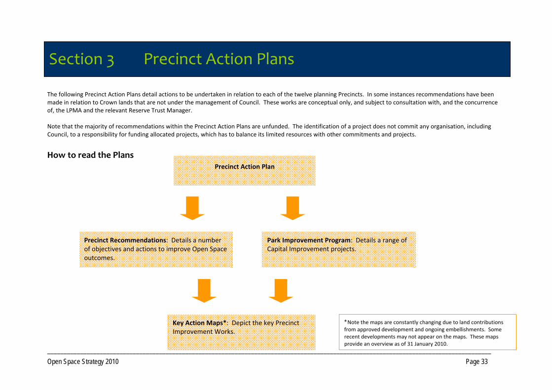
Section 3 Precinct Action Plan The following Precinct Action Plans detail actions to be undertaken in relation to each of the twelve planning Precincts. In some instances recommendations have been made in relation to Crown lands that are not under the management of Council. These works are conceptual only, and subject to consultation with, and the concurrence of, the LPMA and the relevant Reserve Trust Manager. Note that the majority of recommendations within the Precinct Action Plans are unfunded. The identification of a project does not commit any organisation, including Council, to a responsibility for funding allocated projects, which has to balance its limited resources with other commitments and projects.
How to read the Plans
Section 3 Precinct Action Plans
Key Action Maps*: Depict the key Precinct Improvement Works.
Precinct Action Plan
Precinct Recommendations: Details a number of objectives and actions to improve Open Space outcomes.
Park Improvement Program: Details a range of Capital Improvement projects.
* Note the maps are constantly changing due to land contributions from approved development and ongoing embellishments. Some recent developments may not appear on the maps. These maps provide an overview as of 31 January 2010.
_______________________________________________________________________________________________________________________________________ Open Space Strategy 2010 Page 34
Precinct Recommendations This includes broad actions to be undertaken in relation to offsetting Gaps identified within the “Open Space Research Report 1 – Precinct Analysis". In some instances more specific recommendations to meet an opportunity are included in the Park Improvement Program. The following Objectives are addressed:
Provide additional Open Space opportunities. Identifies opportunities to improve Open Space outcomes within the Precinct.
Provide additional land required to service future development. Provides an indication of the likely open space required in the future as development occurs. It is a guide only as future requirements will be dependent on the final residential footprint determined for the identified growth areas and Council's ability to service additional lands.
Integrate management of Open Space to maximise benefits.
Identifies opportunities to align management arrangements where different land tenures occur.
Park Improvement Program This comprises a list of identified capital improvement projects derived from the Open Space Research Reports. The Program has been set out by Catchment (Local, District or Regional) and Function (Open Space type). The Tables incorporate a description of the works, a priority, responsible agency for implementation and current status of the works. Note that in the majority of instances, recommendations relating to sports venue/facility improvements have not been included, as these will be addressed directly within the companion document, the “2010 Coffs Harbour Sports Facility Plan”. The proposed timeframe for implementation that reflects community need is: High
Works substantially commenced within 1‐7 years
Medium
Works substantially commenced within 8 ‐12 years
Low
Works substantially commenced within 13+ years
Outside life of the Plan (O)
Works considered to be outside the life of Plan
As development occurs (ADO)
Works dependant on timing/staging of future development
_______________________________________________________________________________________________________________________________________ Open Space Strategy 2010 Page 35
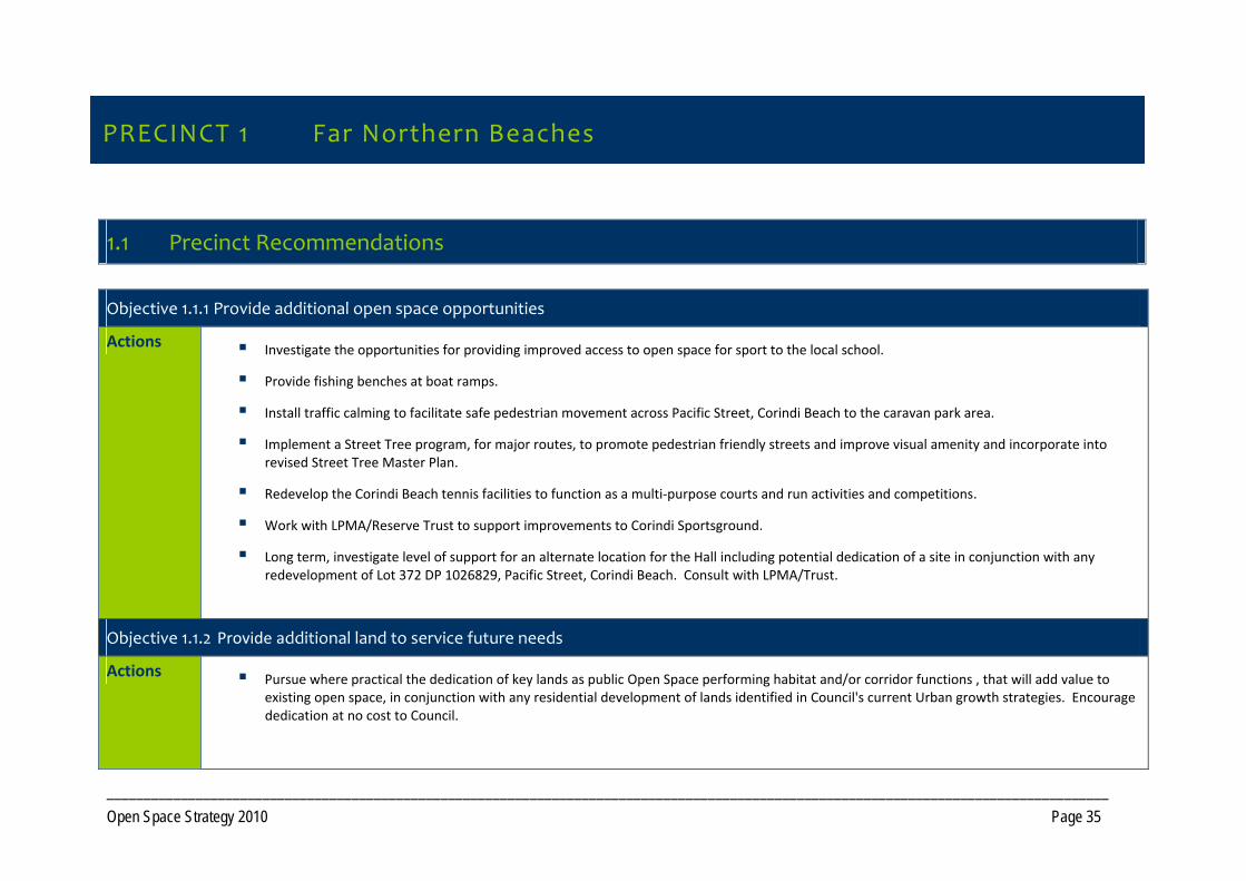
PRECINCT 1 Far Northern Beaches
1.1 Precinct Recommendations
Objective 1.1.1 Provide additional open space opportunities
Actions Investigate the opportunities for providing improved access to open space for sport to the local school.
Provide fishing benches at boat ramps.
Install traffic calming to facilitate safe pedestrian movement across Pacific Street, Corindi Beach to the caravan park area.
Implement a Street Tree program, for major routes, to promote pedestrian friendly streets and improve visual amenity and incorporate into revised Street Tree Master Plan.
Redevelop the Corindi Beach tennis facilities to function as a multi‐purpose courts and run activities and competitions.
Work with LPMA/Reserve Trust to support improvements to Corindi Sportsground.
Long term, investigate level of support for an alternate location for the Hall including potential dedication of a site in conjunction with any redevelopment of Lot 372 DP 1026829, Pacific Street, Corindi Beach. Consult with LPMA/Trust.
Objective 1.1.2 Provide additional land to service future needs
Actions Pursue where practical the dedication of key lands as public Open Space performing habitat and/or corridor functions , that will add value to existing open space, in conjunction with any residential development of lands identified in Council's current Urban growth strategies. Encourage dedication at no cost to Council.
PRECINCT 1 Far Northern Beaches
_______________________________________________________________________________________________________________________________________ Open Space Strategy 2010 Page 36
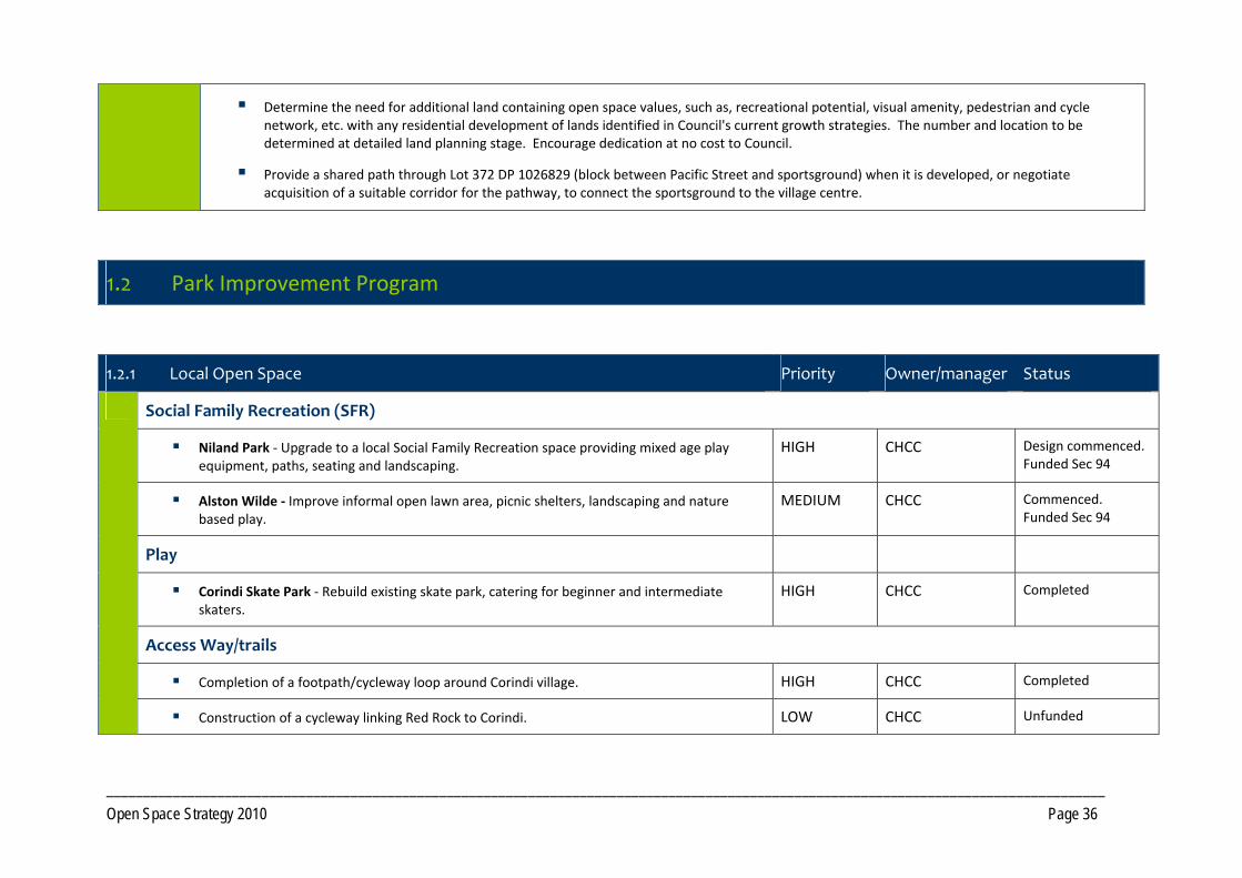
Determine the need for additional land containing open space values, such as, recreational potential, visual amenity, pedestrian and cycle network, etc. with any residential development of lands identified in Council's current growth strategies. The number and location to be determined at detailed land planning stage. Encourage dedication at no cost to Council.
Provide a shared path through Lot 372 DP 1026829 (block between Pacific Street and sportsground) when it is developed, or negotiate acquisition of a suitable corridor for the pathway, to connect the sportsground to the village centre.
1.2 Park Improvement Program
1.2.1 Local Open Space Priority Owner/manager Status
Social Family Recreation (SFR)
Niland Park ‐ Upgrade to a local Social Family Recreation space providing mixed age play equipment, paths, seating and landscaping.
HIGH CHCC Design commenced. Funded Sec 94
Alston Wilde ‐ Improve informal open lawn area, picnic shelters, landscaping and nature based play.
MEDIUM CHCC Commenced. Funded Sec 94
Play
Corindi Skate Park ‐ Rebuild existing skate park, catering for beginner and intermediate skaters.
HIGH CHCC Completed
Access Way/trails
Completion of a footpath/cycleway loop around Corindi village. HIGH CHCC Completed
Construction of a cycleway linking Red Rock to Corindi. LOW CHCC Unfunded
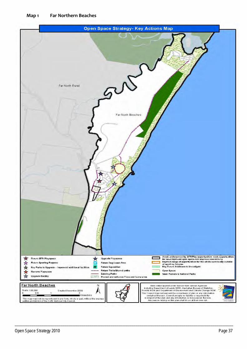
_________________________________________________________________________________________________________ Open Space Strategy 2010 Page 37
Map 1 Far Northern Beaches
________________________________________________________________________________________________________________________________________ Open Space Strategy 2010 Page 38
PRECINCT 2 Woolgoolga
2.1 Precinct Recommendations
Objective 2.1.1 Provide additional open space opportunities
Actions
Create additional local social family recreation spaces to service neighbourhoods in areas under‐served including development of play facilities in conjunction with sports fields and in reserves that are currently below capacity.
Medium term, investigate new location for an upgraded Skate Park in Woolgoolga.
Woolgoolga Swimming Pool ‐ Investigate future demands and requirements of the facility.
Develop a trail network west of the Pacific Highway in Woolgoolga that connects with the existing network, local schools, sports facilities and commercial precincts.
Improve off road trail networks linking Arrawarra, Mullaway, Safety Beach and Woolgoolga including a sealed shared pathway to link Safety Beach to the High School and Woolgoolga Sportsground.
Investigate options to redress boat access points at Arrawarra where vehicles/water craft are being placed directly into the family beach area.
Plan and develop proposed open space west of Pacific Highway as a multi‐purpose sports facility serving the expected projected population.
Improve swimming and non‐motorised water craft opportunities at Woolgoolga Lake.
Investigate options for dog leash free area at Mullaway.
Provide for events including theatre, music and arts in public open space at appropriate times.
Investigate options to secure the future of the Safety Beach Golf Course.
If development occurs south of Crabbe Street Reserve, Woolgoolga, ensure that the Open Space component of the development adjoins the existing reserve.
Development of open space facilities in conjunction with planned development within the West Woolgoolga DCP area.
PRECINCT 2 Woolgoolga
________________________________________________________________________________________________________________________________________ Open Space Strategy 2010 Page 39
Objective 2.1.2 Provide additional land to service future needs
Actions Arrawarra/ Arrawarra Headland
Land to develop one local Social Family Recreation space required if residential redevelopment of Arrawarra Caravan Park occurs. Ensure any future redevelopment of the Caravan Park incorporates public access to the beach, including a new public bridge over Yarrawarra Creek.
Mullaway
Land to develop one local sport function. Investigate suitability of Lot 6 DP 417132, currently zoned 6A, for this purpose. Note the portion of Lot 43 DP 816998 zoned 6A and owned by NPWS not required for acquisition by Council.
Safety Beach
One additional local social family recreation in conjunction with development of future residential lands north of Safety Beach identified within Council's current growth strategy.
Pursue where practical the dedication of key lands as public Open Space performing habitat and/or corridor functions , that will add value to existing open space, in conjunction with any residential development of lands identified in Council's current Urban growth strategies. Encourage dedication at no cost to Council.
Woolgoolga
Create a connected open space network, filling a range of functions including, additional open space for local social family recreation as per Core Service Levels criteria for future residential areas. Note that any social family recreation space required south of Bark Hut Road will ideally adjoin existing Council Reserve. The number and location of open space reserves will be determined at the detailed land planning stage.
Pursue where practical the dedication of key lands as public Open Space performing habitat and/or corridor functions , that will add value to existing open space, in conjunction with any residential development of lands identified in Council's current Urban growth strategies. Encourage dedication at no cost to Council.
Addition of open space in accordance with the final development footprint of the West Woolgoolga DCP area.
Open Space that can provide lunch time relaxation and recreation opportunities in conjunction with planned industrial development west of the Pacific Highway. Ideally this would be located adjacent to flora and fauna conservation areas where trail circuits could then be developed.
Investigate options to acquire management of the riparian area of Lot 21 DP 259757 and Lot 1 DP 567045 to enable revegetation of Poundyard Creek.
Acquisition of Lot‘s 237 and 119 DP 752853; Lots 2, 3, 8, and 9 DP 759113; Lot 360 DP 823586.
Objective 2.1.3 Integrate management of Open Space land parcels to maximise benefits
________________________________________________________________________________________________________________________________________ Open Space Strategy 2010 Page 40
Progress Stage 2 additions to the Coffs Coast Regional Park.
Consult with LPMA/Reserve Trust regarding consideration of the addition of Woolgoolga Beach Reserve to the Coffs Coast State Park.
2.2 Park Improvement Program
2.2.1 District Open Space Priority Responsibility Status
Social Family Recreation
Woolgoolga Beach Reserve ‐ Develop Master Plan for Reserve and embellish to a District Social Family Space through redesign and provision of facilities for wider age ranges, paths, picnic facilities, car parking, and amenities.
HIGH CHCC/LPMA/Reserve Trust
Design commenced. Partially funded. Construct Stage 1 playground and pathways 2010
Arrawarra Headland – Foreshore Reserve ‐ Develop a district level Social Family Space incorporating nature based play equipment for mixed age ranges, BBQ, picnic and seating facilities, new amenities, pathways and landscaping. Rationalise parking and boat access.
HIGH CHCC and NPWS Design commenced. Partially funded NPWS and CHCC
2.2.2 Local Open Space Priority Responsibility Status
Social Family Recreation
Mullaway Beach Reserve ‐ Improve useability of the site through drainage works. Open up visual connectivity between the eastern and western areas of the Reserve. Upgrade playground to include hard court and improve pathways. Improve the connectivity through to the beach from The Boulevarde.
MEDIUM CHCC and NPWS Unfunded. Potential site for fill from highway upgrade works
Play
________________________________________________________________________________________________________________________________________ Open Space Strategy 2010 Page 41
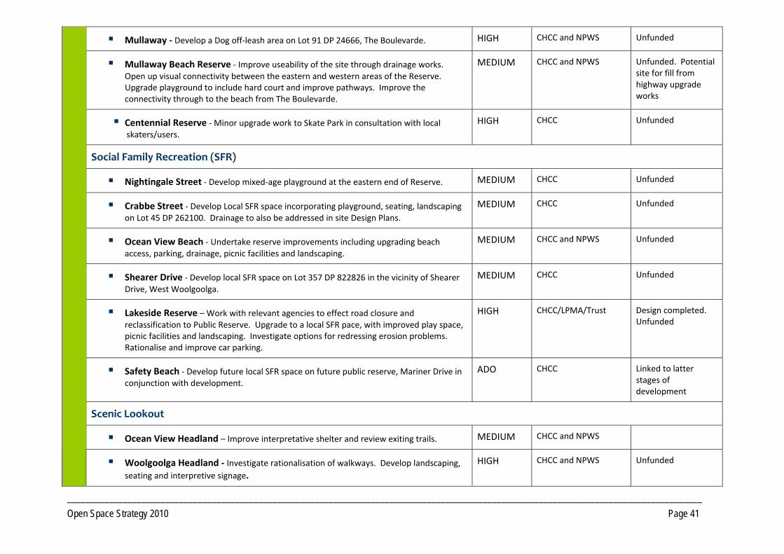
Mullaway ‐ Develop a Dog off‐leash area on Lot 91 DP 24666, The Boulevarde. HIGH CHCC and NPWS Unfunded
Mullaway Beach Reserve ‐ Improve useability of the site through drainage works. Open up visual connectivity between the eastern and western areas of the Reserve. Upgrade playground to include hard court and improve pathways. Improve the connectivity through to the beach from The Boulevarde.
MEDIUM CHCC and NPWS Unfunded. Potential site for fill from highway upgrade works
Centennial Reserve ‐ Minor upgrade work to Skate Park in consultation with local skaters/users.
HIGH CHCC Unfunded
Social Family Recreation (SFR)
Nightingale Street ‐ Develop mixed‐age playground at the eastern end of Reserve. MEDIUM CHCC Unfunded
Crabbe Street ‐ Develop Local SFR space incorporating playground, seating, landscaping on Lot 45 DP 262100. Drainage to also be addressed in site Design Plans.
MEDIUM CHCC Unfunded
Ocean View Beach ‐ Undertake reserve improvements including upgrading beach access, parking, drainage, picnic facilities and landscaping.
MEDIUM CHCC and NPWS Unfunded
Shearer Drive ‐ Develop local SFR space on Lot 357 DP 822826 in the vicinity of Shearer Drive, West Woolgoolga.
MEDIUM CHCC Unfunded
Lakeside Reserve – Work with relevant agencies to effect road closure and reclassification to Public Reserve. Upgrade to a local SFR pace, with improved play space, picnic facilities and landscaping. Investigate options for redressing erosion problems. Rationalise and improve car parking.
HIGH CHCC/LPMA/Trust Design completed. Unfunded
Safety Beach ‐ Develop future local SFR space on future public reserve, Mariner Drive in conjunction with development.
ADO CHCC Linked to latter stages of development
Scenic Lookout
Ocean View Headland – Improve interpretative shelter and review exiting trails. MEDIUM CHCC and NPWS
Woolgoolga Headland ‐ Investigate rationalisation of walkways. Develop landscaping, seating and interpretive signage.
HIGH CHCC and NPWS Unfunded
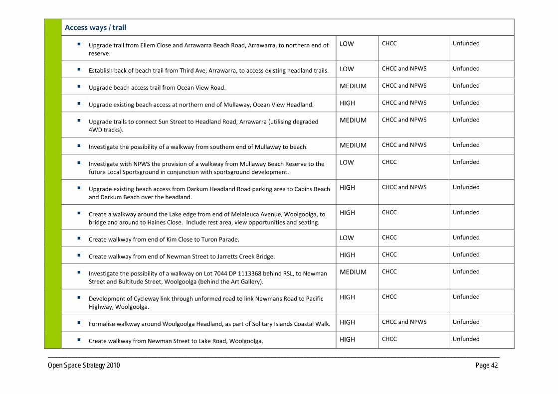
________________________________________________________________________________________________________________________________________ Open Space Strategy 2010 Page 42
Access ways / trail
Upgrade trail from Ellem Close and Arrawarra Beach Road, Arrawarra, to northern end of reserve.
LOW CHCC Unfunded
Establish back of beach trail from Third Ave, Arrawarra, to access existing headland trails. LOW CHCC and NPWS Unfunded
Upgrade beach access trail from Ocean View Road. MEDIUM CHCC and NPWS Unfunded
Upgrade existing beach access at northern end of Mullaway, Ocean View Headland. HIGH CHCC and NPWS Unfunded
Upgrade trails to connect Sun Street to Headland Road, Arrawarra (utilising degraded 4WD tracks).
MEDIUM CHCC and NPWS Unfunded
Investigate the possibility of a walkway from southern end of Mullaway to beach. MEDIUM CHCC and NPWS Unfunded
Investigate with NPWS the provision of a walkway from Mullaway Beach Reserve to the future Local Sportsground in conjunction with sportsground development.
LOW CHCC Unfunded
Upgrade existing beach access from Darkum Headland Road parking area to Cabins Beach and Darkum Beach over the headland.
HIGH CHCC and NPWS Unfunded
Create a walkway around the Lake edge from end of Melaleuca Avenue, Woolgoolga, to bridge and around to Haines Close. Include rest area, view opportunities and seating.
HIGH CHCC Unfunded
Create walkway from end of Kim Close to Turon Parade. LOW CHCC Unfunded
Create walkway from end of Newman Street to Jarretts Creek Bridge. HIGH CHCC Unfunded
Investigate the possibility of a walkway on Lot 7044 DP 1113368 behind RSL, to Newman Street and Bultitude Street, Woolgoolga (behind the Art Gallery).
MEDIUM CHCC Unfunded
Development of Cycleway link through unformed road to link Newmans Road to Pacific Highway, Woolgoolga.
HIGH CHCC Unfunded
Formalise walkway around Woolgoolga Headland, as part of Solitary Islands Coastal Walk. HIGH CHCC and NPWS Unfunded
Create walkway from Newman Street to Lake Road, Woolgoolga. HIGH CHCC Unfunded
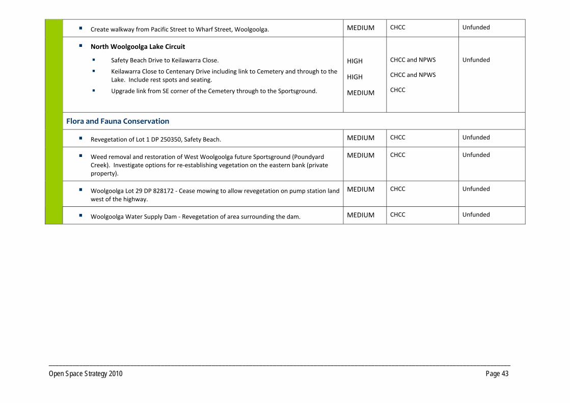
________________________________________________________________________________________________________________________________________ Open Space Strategy 2010 Page 43
Create walkway from Pacific Street to Wharf Street, Woolgoolga. MEDIUM CHCC Unfunded
North Woolgoolga Lake Circuit
Safety Beach Drive to Keilawarra Close.
Keilawarra Close to Centenary Drive including link to Cemetery and through to the Lake. Include rest spots and seating.
Upgrade link from SE corner of the Cemetery through to the Sportsground.
HIGH
HIGH
MEDIUM
CHCC and NPWS
CHCC and NPWS
CHCC
Unfunded
Flora and Fauna Conservation
Revegetation of Lot 1 DP 250350, Safety Beach. MEDIUM CHCC Unfunded
Weed removal and restoration of West Woolgoolga future Sportsground (Poundyard Creek). Investigate options for re‐establishing vegetation on the eastern bank (private property).
MEDIUM CHCC Unfunded
Woolgoolga Lot 29 DP 828172 ‐ Cease mowing to allow revegetation on pump station land west of the highway.
MEDIUM CHCC Unfunded
Woolgoolga Water Supply Dam ‐ Revegetation of area surrounding the dam. MEDIUM CHCC Unfunded
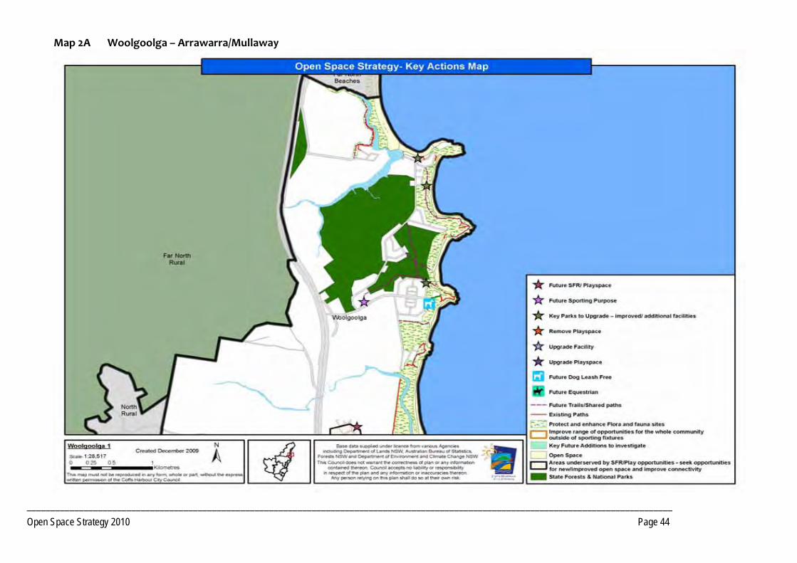
________________________________________________________________________________________________________________________________________ Open Space Strategy 2010 Page 44
Map 2A Woolgoolga – Arrawarra/Mullaway
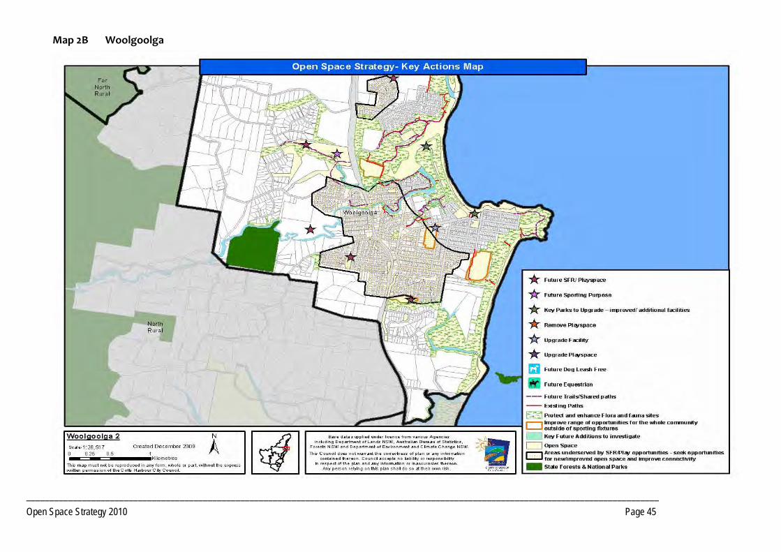
________________________________________________________________________________________________________________________________________ Open Space Strategy 2010 Page 45
Map 2B Woolgoolga
________________________________________________________________________________________________________________________________________ Open Space Strategy 2010 Page 46
PRECINCT 3 Northern Beaches
3.1 Precinct Recommendations Objective 3.1.2 Provide additional open space opportunities Actions Plan and develop proposed open space as a local sports facility/social family space in Sandy Beach, as per the DCP, to serve the village and
surrounding areas.
Develop a trail network that connects the local school, future sports facility and coastal reserves and shops at Sandy Beach.
Development of the coastal walkway and linking trails to service both the Region as well as the local communities.
Develop footpath network at Emerald Beach primarily along the footpaths.
Consider closure of the eastern end of Fiddaman Road and removal of the boat ramp to facilitate Emerald Beach Reserve expansion.
Investigate opportunities for a suitable site for a central skate facility in Moonee Beach. Investigate suitability of Lot 21 DP 1093808.
In conjunction with future development or in co‐operation with private owners, develop walking trails along Moonee Creek from Tiki Road to Bluff Road, Emerald Beach.
Develop social family recreation space, sport and youth facilities as per the final development footprint for Moonee Beach DCP areas, to serve the Northern Beaches and Korora West Precincts and surrounding areas.
Consult with LPMA / Reserve Trust to prepare a site Master Plan for Moonee Beach Reserve with consideration of improved traffic flows, parking, play spaces and picnic facilities.
PRECINCT 3 Northern Beaches
________________________________________________________________________________________________________________________________________ Open Space Strategy 2010 Page 47
Objective 3.1.3 Provide additional land required to service future development
Actions Sandy Beach/Emerald Beach Dedication of Open Space in accordance with the final development footprint of the Sandy Beach/Hearnes Lake DCP area.
Pursue where practical the dedication of additional open space in conjunction with any residential development of lands. Lands should contain open space values, such as recreational potential, pedestrian and cycle network, etc. Number and location to be determined at detailed land planning stage. Encourage dedication at no cost to Council.
Pursue where practical the dedication of key lands as public Open Space performing habitat and/or corridor functions , that will add value to existing open space, in conjunction with any residential development of lands identified in Council's current Urban growth strategies. Encourage dedication at no cost to Council.
Investigate options to acquire management of areas of high conservation significance within Lot 7 DP 245955, Lot 2 DP 702888, and Lot 13 DP 1140702 adjoining Moonee Creek for conservation and access way/trail purposes south of Emerald Beach.
Investigate opportunities to develop a local recreation field in conjunction with any rezoning/development of lands at Emerald Beach.
Moonee Beach/North Sapphire Dedication of open space in accordance with the final development footprint for the Moonee Beach DCP area.
Land for local SFR and Access Way/Trails, as per core service levels criteria, in conjunction with any residential development of lands beyond intent of Moonee DCP, between North Sapphire and Moonee Beach to be determined at DA stage.
Pursue where practical the dedication of key lands as public Open Space performing habitat and/or corridor functions , that will add value to existing open space, in conjunction with any residential development of lands identified in Council's current Urban growth strategies. Encourage dedication at no cost to Council.
Determine the need for additional open space containing Open Space values, such as, recreational potential, visual amenity, pedestrian and cycle network, etc. with any residential development of lands. The number and location to be determined at detailed land planning stage. Encourage dedication at no cost to Council.
Investigate a route for South Moonee Forest walking track and seek dedication of identified land as walkway corridor.
________________________________________________________________________________________________________________________________________ Open Space Strategy 2010 Page 48
Objective 3.1.5 Integrate management of Open Space land parcels to maximise benefits
Actions Support the transfer of Lots 44 DP 752834, Lot 44 DP 245596 and Lot 3A DP 361980, Emerald Beach, to the NPWS for gazettal as conservation reserve.
Progress Stage 2 additions to the Coffs Coast Regional Park.
3.2 Park Improvement Program 3.2.1 District Open Space Priority Responsibility Status
Social Family Recreation (SFR)
Sandy Beach Reserve ‐ Embellish as District SFR space with additional facilities, based on community demand, including junior and senior play equipment, outdoor courts, kick around areas, performance space, picnic facilities and pathways.
HIGH CHCC and NPWS Unfunded
Sandy Beach Foreshore ‐ Improve boat ramp. HIGH CHCC Completed
Emerald Beach ‐ Upgrade Playground and play space to function as a District Social Family Recreation Reserve. Investigate removal of the boat ramp in conjunction with the recommended road closure.
HIGH CHCC and NPWS Unfunded
3.2.2 Local Open Space Priority Responsibility Status
Social Family Recreation
Split Solitary (adjacent to Split Solitary Caravan Park) ‐ Relocation of private recreation facilities to the Caravan Park. Closure of public car park. Long term investigate removal of private cabins on park estate.
HIGH CHCC and NPWS Unfunded
Sapphire Beach Park (Lakeside Drive) ‐ Provide additional picnic tables and seating.
MEDIUM CHCC and NPWS Unfunded
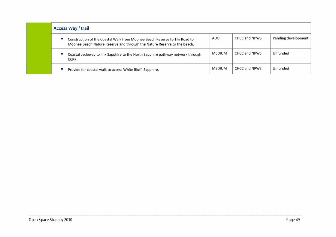
________________________________________________________________________________________________________________________________________ Open Space Strategy 2010 Page 49
Access Way / trail
Construction of the Coastal Walk from Moonee Beach Reserve to Tiki Road to Moonee Beach Nature Reserve and through the Nature Reserve to the beach.
ADO CHCC and NPWS Pending development
Coastal cycleway to link Sapphire to the North Sapphire pathway network through CCRP.
MEDIUM CHCC and NPWS Unfunded
Provide for coastal walk to access White Bluff, Sapphire. MEDIUM CHCC and NPWS Unfunded
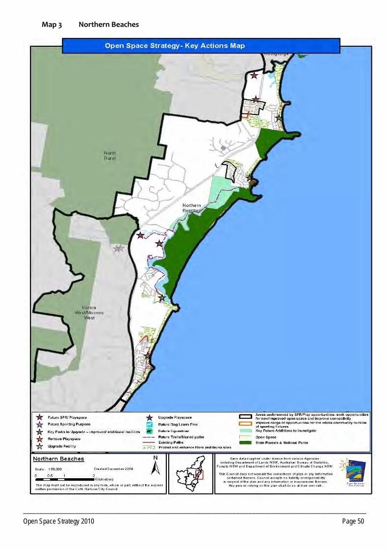
_________________________________________________________________________________________________________ Open Space Strategy 2010 Page 50
Map 3 Northern Beaches
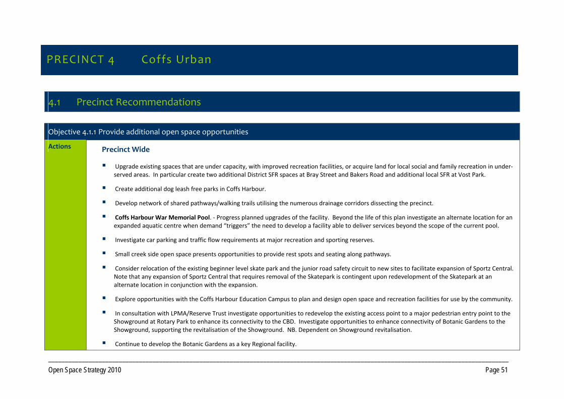
_________________________________________________________________________________________________________________________________________ Open Space Strategy 2010 Page 51
PRECINCT 4 Coffs Urban
4.1 Precinct Recommendations
Objective 4.1.1 Provide additional open space opportunities
Actions Precinct Wide
Upgrade existing spaces that are under capacity, with improved recreation facilities, or acquire land for local social and family recreation in under‐served areas. In particular create two additional District SFR spaces at Bray Street and Bakers Road and additional local SFR at Vost Park.
Create additional dog leash free parks in Coffs Harbour.
Develop network of shared pathways/walking trails utilising the numerous drainage corridors dissecting the precinct.
Coffs Harbour War Memorial Pool. ‐ Progress planned upgrades of the facility. Beyond the life of this plan investigate an alternate location for an expanded aquatic centre when demand “triggers” the need to develop a facility able to deliver services beyond the scope of the current pool.
Investigate car parking and traffic flow requirements at major recreation and sporting reserves.
Small creek side open space presents opportunities to provide rest spots and seating along pathways.
Consider relocation of the existing beginner level skate park and the junior road safety circuit to new sites to facilitate expansion of Sportz Central. Note that any expansion of Sportz Central that requires removal of the Skatepark is contingent upon redevelopment of the Skatepark at an alternate location in conjunction with the expansion.
Explore opportunities with the Coffs Harbour Education Campus to plan and design open space and recreation facilities for use by the community.
In consultation with LPMA/Reserve Trust investigate opportunities to redevelop the existing access point to a major pedestrian entry point to the Showground at Rotary Park to enhance its connectivity to the CBD. Investigate opportunities to enhance connectivity of Botanic Gardens to the Showground, supporting the revitalisation of the Showground. NB. Dependent on Showground revitalisation.
Continue to develop the Botanic Gardens as a key Regional facility.
PRECINCT 4 Coffs Urban
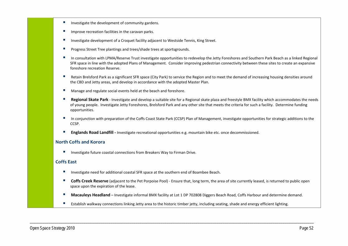
_________________________________________________________________________________________________________________________________________ Open Space Strategy 2010 Page 52
Investigate the development of community gardens.
Improve recreation facilities in the caravan parks.
Investigate development of a Croquet facility adjacent to Westside Tennis, King Street.
Progress Street Tree plantings and trees/shade trees at sportsgrounds.
In consultation with LPMA/Reserve Trust investigate opportunities to redevelop the Jetty Foreshores and Southern Park Beach as a linked Regional SFR space in line with the adopted Plans of Management. Consider improving pedestrian connectivity between these sites to create an expansive foreshore recreation Reserve.
Retain Brelsford Park as a significant SFR space (City Park) to service the Region and to meet the demand of increasing housing densities around the CBD and Jetty areas, and develop in accordance with the adopted Master Plan.
Manage and regulate social events held at the beach and foreshore.
Regional Skate Park ‐ Investigate and develop a suitable site for a Regional skate plaza and freestyle BMX facility which accommodates the needs of young people. Investigate Jetty Foreshores, Brelsford Park and any other site that meets the criteria for such a facility. Determine funding opportunities.
In conjunction with preparation of the Coffs Coast State Park (CCSP) Plan of Management, investigate opportunities for strategic additions to the CCSP.
Englands Road Landfill ‐ Investigate recreational opportunities e.g. mountain bike etc. once decommissioned.
North Coffs and Korora
Investigate future coastal connections from Breakers Way to Firman Drive.
Coffs East
Investigate need for additional coastal SFR space at the southern end of Boambee Beach.
Coffs Creek Reserve (adjacent to the Pet Porpoise Pool) ‐ Ensure that, long term, the area of site currently leased, is returned to public open space upon the expiration of the lease.
Macauleys Headland – Investigate informal BMX facility at Lot 1 DP 702808 Diggers Beach Road, Coffs Harbour and determine demand.
Establish walkway connections linking Jetty area to the historic timber jetty, including seating, shade and energy efficient lighting.
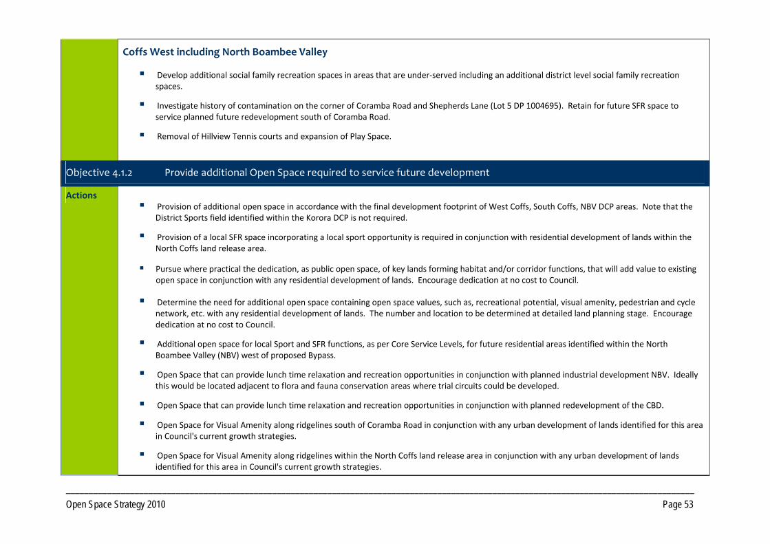
_________________________________________________________________________________________________________________________________________ Open Space Strategy 2010 Page 53
Coffs West including North Boambee Valley
Develop additional social family recreation spaces in areas that are under‐served including an additional district level social family recreation spaces.
Investigate history of contamination on the corner of Coramba Road and Shepherds Lane (Lot 5 DP 1004695). Retain for future SFR space to service planned future redevelopment south of Coramba Road.
Removal of Hillview Tennis courts and expansion of Play Space.
Objective 4.1.2 Provide additional Open Space required to service future development
Actions Provision of additional open space in accordance with the final development footprint of West Coffs, South Coffs, NBV DCP areas. Note that the
District Sports field identified within the Korora DCP is not required.
Provision of a local SFR space incorporating a local sport opportunity is required in conjunction with residential development of lands within the North Coffs land release area.
Pursue where practical the dedication, as public open space, of key lands forming habitat and/or corridor functions, that will add value to existing open space in conjunction with any residential development of lands. Encourage dedication at no cost to Council.
Determine the need for additional open space containing open space values, such as, recreational potential, visual amenity, pedestrian and cycle network, etc. with any residential development of lands. The number and location to be determined at detailed land planning stage. Encourage dedication at no cost to Council.
Additional open space for local Sport and SFR functions, as per Core Service Levels, for future residential areas identified within the North Boambee Valley (NBV) west of proposed Bypass.
Open Space that can provide lunch time relaxation and recreation opportunities in conjunction with planned industrial development NBV. Ideally this would be located adjacent to flora and fauna conservation areas where trial circuits could be developed.
Open Space that can provide lunch time relaxation and recreation opportunities in conjunction with planned redevelopment of the CBD.
Open Space for Visual Amenity along ridgelines south of Coramba Road in conjunction with any urban development of lands identified for this area in Council's current growth strategies.
Open Space for Visual Amenity along ridgelines within the North Coffs land release area in conjunction with any urban development of lands identified for this area in Council's current growth strategies.
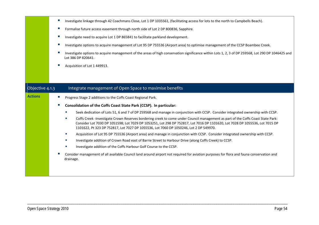
_________________________________________________________________________________________________________________________________________ Open Space Strategy 2010 Page 54
Investigate linkage through 42 Coachmans Close, Lot 1 DP 1035561, (facilitating access for lots to the north to Campbells Beach).
Formalise future access easement through north side of Lot 2 DP 800836, Sapphire.
Investigate need to acquire Lot 1 DP 865841 to facilitate parkland development.
Investigate options to acquire management of Lot 95 DP 755536 (Airport area) to optimise management of the CCSP Boambee Creek.
Investigate options to acquire management of the areas of high conservation significance within Lots 1, 2, 3 of DP 259568, Lot 290 DP 1046425 and Lot 386 DP 820641.
Acquisition of Lot 1 449913.
Objective 4.1.3 Integrate management of Open Space to maximise benefits
Actions Progress Stage 2 additions to the Coffs Coast Regional Park.
Consolidation of the Coffs Coast State Park (CCSP). In particular:
Seek dedication of Lots 51, 6 and 7 of DP 259568 and manage in conjunction with CCSP. Consider integrated ownership with CCSP.
Coffs Creek ‐Investigate Crown Reserves bordering creek to come under Council management as part of the Coffs Coast State Park: Consider Lot 7030 DP 1051598; Lot 7029 DP 1053251, Lot 298 DP 752817, Lot 7016 DP 1101620, Lot 7028 DP 1055536, Lot 7015 DP 1101622, Pt 323 DP 752817, Lot 7027 DP 1055536, Lot 7060 DP 1050246, Lot 2 DP 549970.
Acquisition of Lot 95 DP 755536 (Airport area) and manage in conjunction with CCSP. Consider integrated ownership with CCSP.
Investigate addition of Crown Road east of Barrie Street to Harbour Drive (along Coffs Creek) to CCSP.
Investigate addition of the Coffs Harbour Golf Course to the CCSP.
Consider management of all available Council land around airport not required for aviation purposes for flora and fauna conservation and drainage.
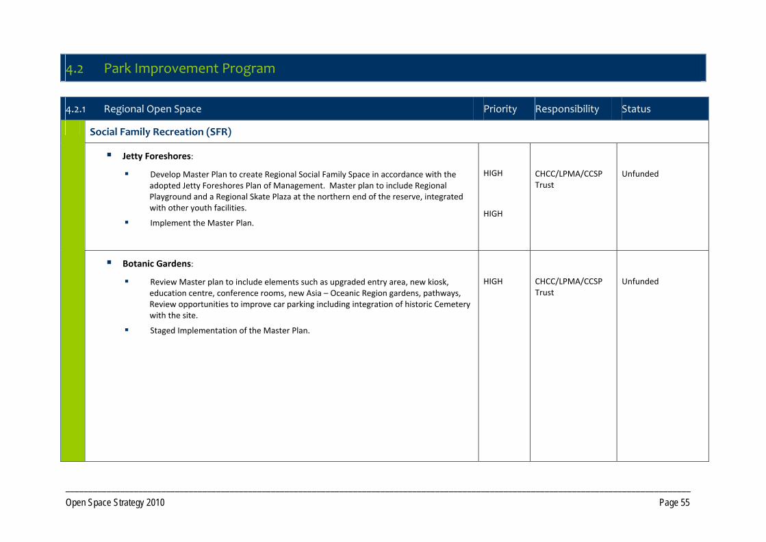
_________________________________________________________________________________________________________________________________________ Open Space Strategy 2010 Page 55
4.2 Park Improvement Program
4.2.1 Regional Open Space Priority Responsibility Status
Social Family Recreation (SFR)
Jetty Foreshores:
Develop Master Plan to create Regional Social Family Space in accordance with the adopted Jetty Foreshores Plan of Management. Master plan to include Regional Playground and a Regional Skate Plaza at the northern end of the reserve, integrated with other youth facilities.
Implement the Master Plan.
HIGH
HIGH
CHCC/LPMA/CCSP Trust
Unfunded
Botanic Gardens:
Review Master plan to include elements such as upgraded entry area, new kiosk, education centre, conference rooms, new Asia – Oceanic Region gardens, pathways, Review opportunities to improve car parking including integration of historic Cemetery with the site.
Staged Implementation of the Master Plan.
HIGH
CHCC/LPMA/CCSP Trust
Unfunded
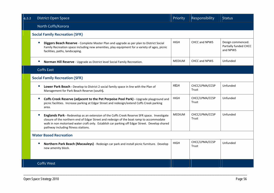
_________________________________________________________________________________________________________________________________________ Open Space Strategy 2010 Page 56
4.2.2 District Open Space Priority Responsibility Status
North Coffs/Korora
Social Family Recreation (SFR)
Diggers Beach Reserve ‐ Complete Master Plan and upgrade as per plan to District Social Family Recreation space including new amenities, play equipment for a variety of ages, picnic facilities, paths, landscaping.
HIGH CHCC and NPWS Design commenced. Partially funded CHCC and NPWS
Norman Hill Reserve ‐ Upgrade as District level Social Family Recreation. MEDIUM CHCC and NPWS Unfunded
Coffs East
Social Family Recreation (SFR)
Lower Park Beach ‐ Develop to District 2 social family space in line with the Plan of Management for Park Beach Reserve (south).
HIGH CHCC/LPMA/CCSP Trust
Unfunded
Coffs Creek Reserve (adjacent to the Pet Porpoise Pool Park) ‐ Upgrade playground and picnic facilities. Increase parking at Edgar Street and redesign/extend Coffs Creek parking area.
HIGH CHCC/LPMA/CCSP Trust
Unfunded
Englands Park ‐ Redevelop as an extension of the Coffs Creek Reserve SFR space. Investigate closure of the northern end of Edgar Street and redesign of the boat ramp to accommodate walk in non motorised water craft only. Establish car parking off Edgar Street. Develop shared pathway including fitness stations.
MEDIUM CHCC/LPMA/CCSP Trust
Unfunded
Water Based Recreation
Northern Park Beach (Macauleys) ‐ Redesign car park and install picnic furniture. Develop new amenity block.
HIGH CHCC/LPMA/CCSP Trust
Unfunded
Coffs West
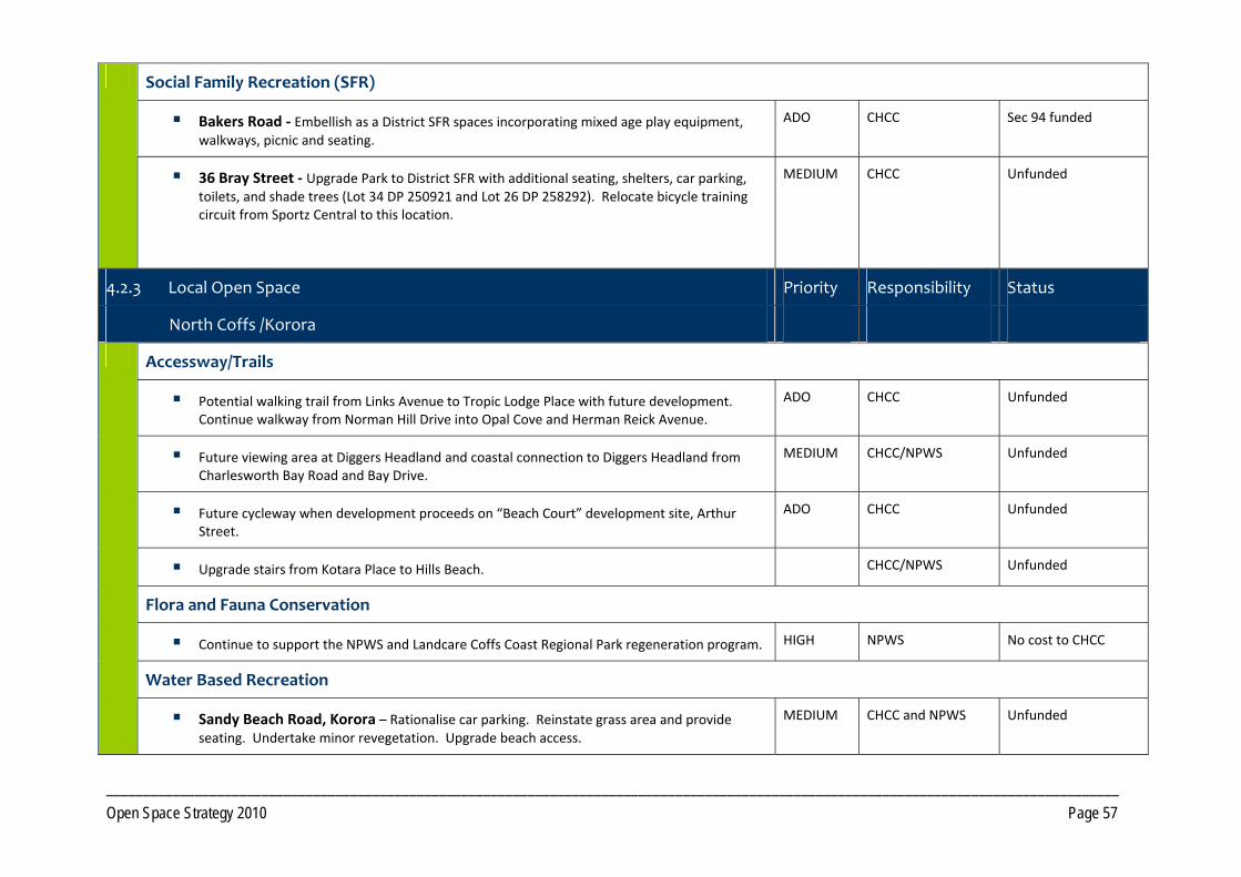
_________________________________________________________________________________________________________________________________________ Open Space Strategy 2010 Page 57
Social Family Recreation (SFR)
Bakers Road ‐ Embellish as a District SFR spaces incorporating mixed age play equipment, walkways, picnic and seating.
ADO CHCC Sec 94 funded
36 Bray Street ‐ Upgrade Park to District SFR with additional seating, shelters, car parking, toilets, and shade trees (Lot 34 DP 250921 and Lot 26 DP 258292). Relocate bicycle training circuit from Sportz Central to this location.
MEDIUM CHCC Unfunded
4.2.3 Local Open Space Priority Responsibility Status
North Coffs /Korora
Accessway/Trails
Potential walking trail from Links Avenue to Tropic Lodge Place with future development. Continue walkway from Norman Hill Drive into Opal Cove and Herman Reick Avenue.
ADO CHCC Unfunded
Future viewing area at Diggers Headland and coastal connection to Diggers Headland from Charlesworth Bay Road and Bay Drive.
MEDIUM CHCC/NPWS Unfunded
Future cycleway when development proceeds on “Beach Court” development site, Arthur Street.
ADO CHCC Unfunded
Upgrade stairs from Kotara Place to Hills Beach. CHCC/NPWS Unfunded
Flora and Fauna Conservation
Continue to support the NPWS and Landcare Coffs Coast Regional Park regeneration program. HIGH NPWS No cost to CHCC
Water Based Recreation
Sandy Beach Road, Korora – Rationalise car parking. Reinstate grass area and provide seating. Undertake minor revegetation. Upgrade beach access.
MEDIUM CHCC and NPWS Unfunded
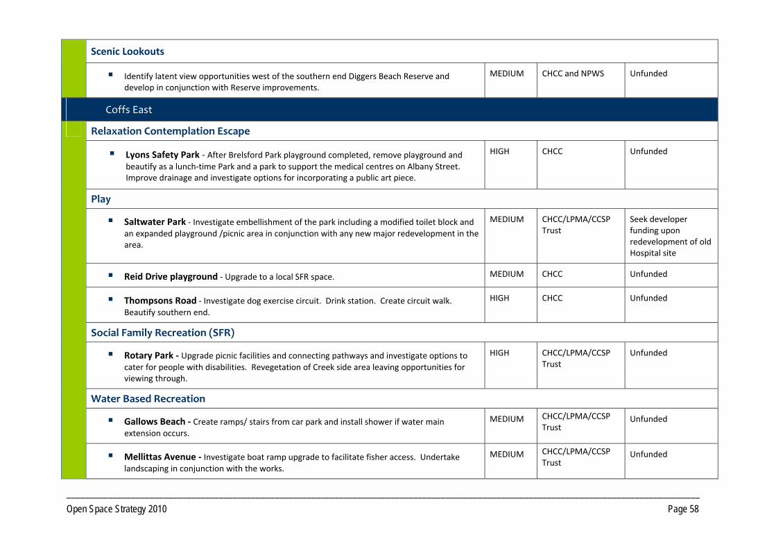
_________________________________________________________________________________________________________________________________________ Open Space Strategy 2010 Page 58
Scenic Lookouts
Identify latent view opportunities west of the southern end Diggers Beach Reserve and develop in conjunction with Reserve improvements.
MEDIUM CHCC and NPWS Unfunded
Coffs East
Relaxation Contemplation Escape
Lyons Safety Park ‐ After Brelsford Park playground completed, remove playground and beautify as a lunch‐time Park and a park to support the medical centres on Albany Street. Improve drainage and investigate options for incorporating a public art piece.
HIGH CHCC Unfunded
Play
Saltwater Park ‐ Investigate embellishment of the park including a modified toilet block and an expanded playground /picnic area in conjunction with any new major redevelopment in the area.
MEDIUM CHCC/LPMA/CCSP Trust
Seek developer funding upon redevelopment of old Hospital site
Reid Drive playground ‐ Upgrade to a local SFR space. MEDIUM CHCC Unfunded
Thompsons Road ‐ Investigate dog exercise circuit. Drink station. Create circuit walk. Beautify southern end.
HIGH CHCC Unfunded
Social Family Recreation (SFR)
Rotary Park ‐ Upgrade picnic facilities and connecting pathways and investigate options to cater for people with disabilities. Revegetation of Creek side area leaving opportunities for viewing through.
HIGH CHCC/LPMA/CCSP Trust
Unfunded
Water Based Recreation
Gallows Beach ‐ Create ramps/ stairs from car park and install shower if water main extension occurs.
MEDIUM CHCC/LPMA/CCSP Trust
Unfunded
Mellittas Avenue ‐ Investigate boat ramp upgrade to facilitate fisher access. Undertake landscaping in conjunction with the works.
MEDIUM CHCC/LPMA/CCSP Trust
Unfunded
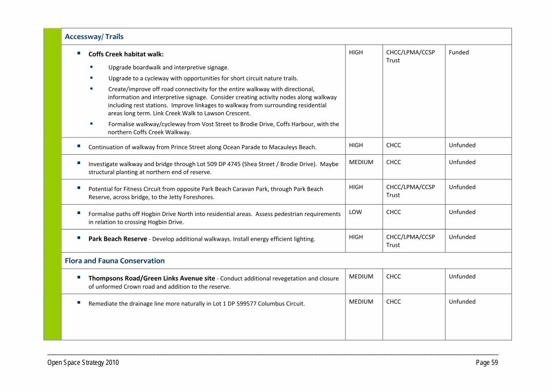
_________________________________________________________________________________________________________________________________________ Open Space Strategy 2010 Page 59
Accessway/ Trails
Coffs Creek habitat walk:
Upgrade boardwalk and interpretive signage.
Upgrade to a cycleway with opportunities for short circuit nature trails.
Create/improve off road connectivity for the entire walkway with directional, information and interpretive signage. Consider creating activity nodes along walkway including rest stations. Improve linkages to walkway from surrounding residential areas long term. Link Creek Walk to Lawson Crescent.
Formalise walkway/cycleway from Vost Street to Brodie Drive, Coffs Harbour, with the northern Coffs Creek Walkway.
HIGH CHCC/LPMA/CCSP Trust
Funded
Continuation of walkway from Prince Street along Ocean Parade to Macauleys Beach. HIGH CHCC Unfunded
Investigate walkway and bridge through Lot 509 DP 4745 (Shea Street / Brodie Drive). Maybe structural planting at northern end of reserve.
MEDIUM CHCC Unfunded
Potential for Fitness Circuit from opposite Park Beach Caravan Park, through Park Beach Reserve, across bridge, to the Jetty Foreshores.
HIGH CHCC/LPMA/CCSP Trust
Unfunded
Formalise paths off Hogbin Drive North into residential areas. Assess pedestrian requirements in relation to crossing Hogbin Drive.
LOW CHCC Unfunded
Park Beach Reserve ‐ Develop additional walkways. Install energy efficient lighting. HIGH CHCC/LPMA/CCSP Trust
Unfunded
Flora and Fauna Conservation
Thompsons Road/Green Links Avenue site ‐ Conduct additional revegetation and closure of unformed Crown road and addition to the reserve.
MEDIUM CHCC Unfunded
Remediate the drainage line more naturally in Lot 1 DP 599577 Columbus Circuit.
MEDIUM CHCC Unfunded
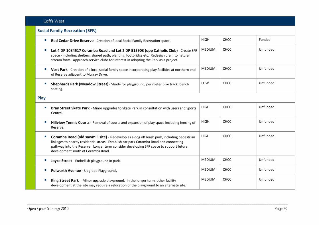
_________________________________________________________________________________________________________________________________________ Open Space Strategy 2010 Page 60
Coffs West
Social Family Recreation (SFR)
Red Cedar Drive Reserve ‐ Creation of local Social Family Recreation space. HIGH CHCC Funded
Lot 4 DP 1084517 Coramba Road and Lot 2 DP 515903 (opp Catholic Club) ‐ Create SFR space ‐ including shelters, shared path, planting, footbridge etc. Redesign drain to natural stream form. Approach service clubs for interest in adopting the Park as a project.
MEDIUM CHCC Unfunded
Vost Park ‐ Creation of a local social family space incorporating play facilities at northern end of Reserve adjacent to Murray Drive.
MEDIUM CHCC Unfunded
Shephards Park (Meadow Street) ‐ Shade for playground, perimeter bike track, bench seating.
LOW CHCC Unfunded
Play
Bray Street Skate Park ‐ Minor upgrades to Skate Park in consultation with users and Sportz Central.
HIGH CHCC Unfunded
Hillview Tennis Courts ‐ Removal of courts and expansion of play space including fencing of Reserve.
HIGH CHCC Unfunded
Coramba Road (old sawmill site) ‐ Redevelop as a dog off leash park, including pedestrian linkages to nearby residential areas. Establish car park Coramba Road and connecting pathway into the Reserve. Longer term consider developing SFR space to support future development south of Coramba Road.
HIGH CHCC Unfunded
Joyce Street ‐ Embellish playground in park. MEDIUM CHCC Unfunded
Polwarth Avenue ‐ Upgrade Playground. MEDIUM CHCC Unfunded
King Street Park ‐ Minor upgrade playground. In the longer term, other facility development at the site may require a relocation of the playground to an alternate site.
MEDIUM CHCC Unfunded
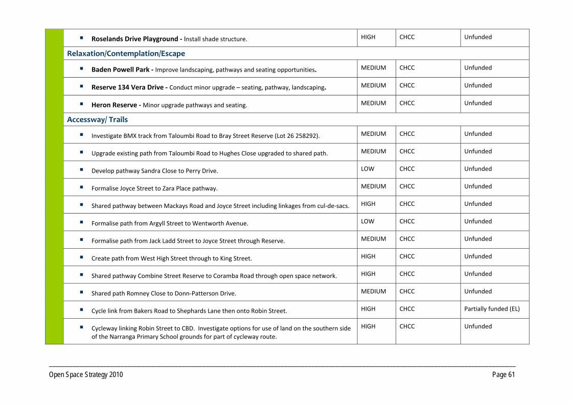
_________________________________________________________________________________________________________________________________________ Open Space Strategy 2010 Page 61
Roselands Drive Playground ‐ Install shade structure. HIGH CHCC Unfunded
Relaxation/Contemplation/Escape
Baden Powell Park ‐ Improve landscaping, pathways and seating opportunities. MEDIUM CHCC Unfunded
Reserve 134 Vera Drive ‐ Conduct minor upgrade – seating, pathway, landscaping. MEDIUM CHCC Unfunded
Heron Reserve ‐ Minor upgrade pathways and seating. MEDIUM CHCC Unfunded
Accessway/ Trails
Investigate BMX track from Taloumbi Road to Bray Street Reserve (Lot 26 258292). MEDIUM CHCC Unfunded
Upgrade existing path from Taloumbi Road to Hughes Close upgraded to shared path. MEDIUM CHCC Unfunded
Develop pathway Sandra Close to Perry Drive. LOW CHCC Unfunded
Formalise Joyce Street to Zara Place pathway. MEDIUM CHCC Unfunded
Shared pathway between Mackays Road and Joyce Street including linkages from cul‐de‐sacs. HIGH CHCC Unfunded
Formalise path from Argyll Street to Wentworth Avenue. LOW CHCC Unfunded
Formalise path from Jack Ladd Street to Joyce Street through Reserve. MEDIUM CHCC Unfunded
Create path from West High Street through to King Street. HIGH CHCC Unfunded
Shared pathway Combine Street Reserve to Coramba Road through open space network. HIGH CHCC Unfunded
Shared path Romney Close to Donn‐Patterson Drive. MEDIUM CHCC Unfunded
Cycle link from Bakers Road to Shephards Lane then onto Robin Street. HIGH CHCC Partially funded (EL)
Cycleway linking Robin Street to CBD. Investigate options for use of land on the southern side of the Narranga Primary School grounds for part of cycleway route.
HIGH CHCC Unfunded
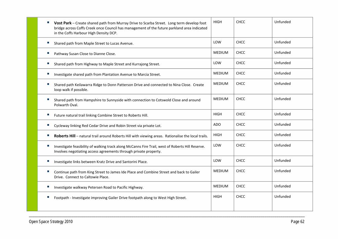
_________________________________________________________________________________________________________________________________________ Open Space Strategy 2010 Page 62
Vost Park – Create shared path from Murray Drive to Scarba Street. Long term develop foot bridge across Coffs Creek once Council has management of the future parkland area indicated in the Coffs Harbour High Density DCP.
HIGH CHCC Unfunded
Shared path from Maple Street to Lucas Avenue. LOW CHCC Unfunded
Pathway Susan Close to Dianne Close. MEDIUM CHCC Unfunded
Shared path from Highway to Maple Street and Kurrajong Street. LOW CHCC Unfunded
Investigate shared path from Plantation Avenue to Marcia Street. MEDIUM CHCC Unfunded
Shared path Keilawarra Ridge to Donn Patterson Drive and connected to Nina Close. Create loop walk if possible.
MEDIUM CHCC Unfunded
Shared path from Hampshire to Sunnyside with connection to Cotswold Close and around Polwarth Oval.
MEDIUM CHCC Unfunded
Future natural trail linking Combine Street to Roberts Hill. HIGH CHCC Unfunded
Cycleway linking Red Cedar Drive and Robin Street via private Lot. ADO CHCC Unfunded
Roberts Hill – natural trail around Roberts Hill with viewing areas. Rationalise the local trails. HIGH CHCC Unfunded
Investigate feasibility of walking track along McCanns Fire Trail, west of Roberts Hill Reserve. Involves negotiating access agreements through private property.
LOW CHCC Unfunded
Investigate links between Kratz Drive and Santorini Place. LOW CHCC Unfunded
Continue path from King Street to James Ide Place and Combine Street and back to Gailer Drive. Connect to Caltowie Place.
MEDIUM CHCC Unfunded
Investigate walkway Petersen Road to Pacific Highway. MEDIUM CHCC Unfunded
Footpath ‐ Investigate improving Gailer Drive footpath along to West High Street.
HIGH CHCC Unfunded
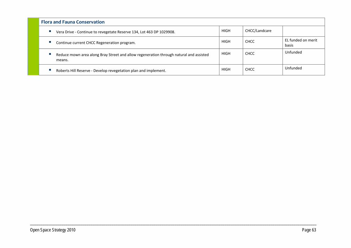
_________________________________________________________________________________________________________________________________________ Open Space Strategy 2010 Page 63
Flora and Fauna Conservation
Vera Drive ‐ Continue to revegetate Reserve 134, Lot 463 DP 1029908. HIGH CHCC/Landcare
Continue current CHCC Regeneration program. HIGH CHCC EL funded on merit basis
Reduce mown area along Bray Street and allow regeneration through natural and assisted means.
HIGH CHCC Unfunded
Roberts Hill Reserve ‐ Develop revegetation plan and implement. HIGH CHCC Unfunded
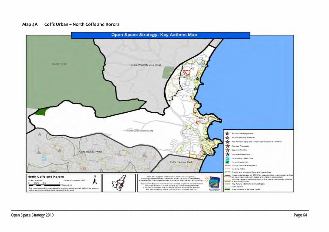
________________________________________________________________________________________________________________________________________________________ Open Space Strategy 2010 Page 64
Map 4A Coffs Urban – North Coffs and Korora
________________________________________________________________________________________________________________________________________________________ Open Space Strategy 2010 Page 65
Map 4B Coffs Urban ‐ Coffs East 1
________________________________________________________________________________________________________________________________________________________ Open Space Strategy 2010 Page 66
Map 4C Coffs Urban ‐ Coffs East 2
________________________________________________________________________________________________________________________________________________________ Open Space Strategy 2010 Page 67
Map 4D Coffs Urban ‐ Coffs West
________________________________________________________________________________________________________________________________________ Open Space Strategy 2010 Page 68
PRECINCT 5 Korora West/Moonee West
5.1 Precinct Recommendations
Objective 5.1 1 Provide additional open space opportunities Actions
Improve off road trail linkages to surrounding current and future Open Space opportunities in adjoining precincts.
Consider pedestrian linkage over the Pacific Highway to link Moonee East and West, in the vicinity of the future sports field.
Develop Social Family Recreation space in conjunction with the future sportsground development.
Objective 5.1 2 Provide additional Open Space required to service future development
Actions Dedicate land for one District level Sport function incorporating a SFR space, as per Core Service level provision, to accord with location shown in Moonee Beach DCP to service Korora West, Moonee Beach and the Northern Beaches.
Dedication of open space as per the final development footprint for the Moonee Beach DCP area.
Pursue where practical the dedication, as public Open Space, of key lands forming habitat and/or corridor functions, that will add value to existing open space in conjunction with any residential development of lands. Encourage dedication at no cost to Council.
Acquisition of Lot 9 DP 1140702.
PRECINCT 5 Korora West/Moonee West
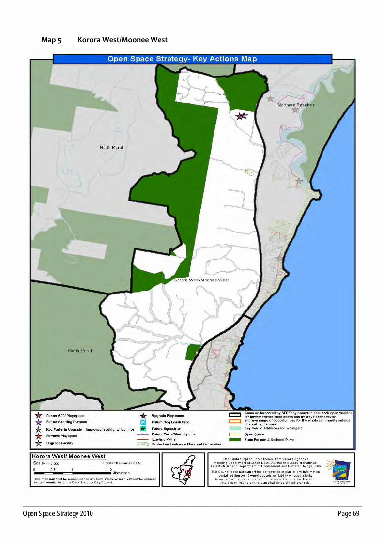
_________________________________________________________________________________________________________ Open Space Strategy 2010 Page 69
Map 5 Korora West/Moonee West
________________________________________________________________________________________________________________________________________ Open Space Strategy 2010 Page 70
PRECINCT 6 Middle Boambee
6.1 Precinct Recommendations Objective 6.1.1 Provide additional open space opportunities Actions
Development of a local SFR space at Ayrshire Park co‐located with the Soccer Fields.
Objective 6.1.2 Provide additional land required to service new development Actions Addition of Open Space in conjunction with any residential development of the area previously covered by the Boambee Creek DCP. Number
and location of open space reserves to determined at detailed land planning stage.
6.2 Park Improvement Program
6.2.1 District Open Space Priority Responsibility Status
Social Family Recreation (SFR)
Ayrshire Park ‐ Development of a local SFR space (incorporating low key children’s playground) at the southern end of the Reserve. Upgrade the existing footbridge and create a circuit walk around the perimeter of the grounds.
HIGH CHCC Bridge funded. Construction to commence late 2010.
PRECINCT 6 Middle Boambee
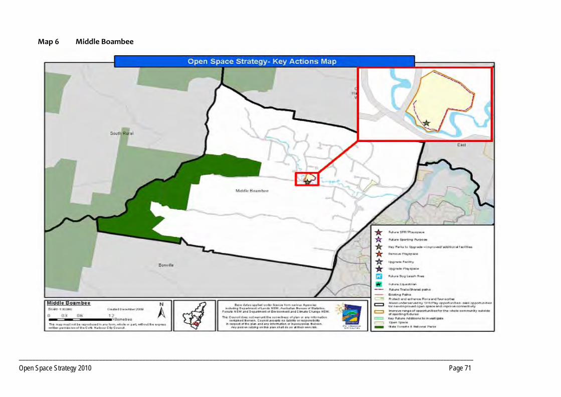
________________________________________________________________________________________________________________________________________ Open Space Strategy 2010 Page 71
Map 6 Middle Boambee
_________________________________________________________________________________________________________________________________________ Open Space Strategy 2010 Page 72
PRECINCT 7 Sawtell / Toormina / Boambee
7.1 Precinct Recommendations
Objective 7.1.1 Provide additional open space opportunities
Actions Sawtell Sewerage Treatment Plant ‐ Investigate development for Open Space and Recreation purposes upon decommissioning. Potential uses include sport, conservation, walking, cycling, mountain biking.
Investigate and acquire land for social and family recreation in neighbourhoods under‐served or, if acquisition not feasible, investigate opportunities to provide good off road linkages to nearby Reserves.
Support the continued operation of the Sawtell Golf Club and the retention of the Crown land, in perpetuity, for sporting and recreation purposes.
Investigate opportunities, in conjunction with future developments within the southern Sawtell area, for provision of a social family recreation space to improve recreation outcomes for the southern area currently serviced by a small park containing only basic play opportunities with no scope for expansion.
Upgrading of play spaces to social family recreation space where opportunity is present. In particular at Amaroo Crescent, Graff Avenue, Lady Belmore Drive, Jane Circuit.
Undertake strategic upgrades of play grounds where no opportunity exists to create a SFR space servicing the catchment. In particular Borrowdale Crescent; Lady Belmore Drive; Jane Circuit; Bower Crescent. Consider removal of playground Dews Avenue and redevelopment of space as access way/trail.
Investigate potential for a fishing platform on Bonville Creek at Boronia Park.
Create an additional district level social family recreation space at Bruce King Drive, incorporating mixed age play (including skate/BMX), local sports field, pathways and opportunities for adolescents, to assist in offsetting lack of local social family recreation and youth facility provision
PRECINCT 7 Sawtell / Toormina / Boambee
_________________________________________________________________________________________________________________________________________ Open Space Strategy 2010 Page 73
within Boambee/Boambee East. Connectivity to under‐served areas to the north‐east could be improved by a pedestrian bridge across Cordwells Creek and a network of off‐road trails to Sawtell Road. Similarly, connectivity to under‐served areas to the south could also be improved through development of an off‐road trail network.
Boambee Creek Reserve – Consult with LPMA/Trust to redesign with improved traffic circulation and parking, protection of bank areas, shelters, play equipment, seating, picnic facilities, kiosk.
Investigate the demand for and feasibility of redeveloping the Sawtell Tennis Courts as a Regional Tennis Centre, co located with other leisure opportunities
Sawtell Swimming Pool ‐ Conduct a study into the future demands, requirements and management options of the facility. In the longer term, consider development of a new local aquatic centre to service southern areas of the LGA co‐located with the proposed Regional Tennis Centre.
Develop trail network through Hulberts Road Sport Reserve.
Identify options for safe crossing of Sawtell Road, at the Boambee Creek Bridge, to link with existing cycleway.
Long term, investigate options for developing a walkways between Hi Tech Drive and Sawtell Road utilising land currently in private ownership.
Investigate options for a walkway linking Hogbin Drive and Hamilton Drive if public reserve dedication occurs.
Investigate shared walkway from bridge west and looped around to Sawtell Road.
Improve linkages for cycleway along Sawtell Road.
Objective 7.1.2 Provide additional Open Space Required to service future development Actions As development occurs seek opportunities for new/expanded open space to develop local SFR spaces in areas identified as under‐served
throughout Toormina/Boambee East.
One Local SFR space, as per Core Service Level provisions in conjunction with any redevelopment of the Sawtell Golf Course.
Pursue where practical the dedication, as public Open Space, of key lands forming habitat and/or corridor functions, that will add value to existing open space in conjunction with any residential development of lands. Encourage dedication at no cost to Council.
Pursue where practical the dedication of additional open space in conjunction with any urban development of lands identified in Council's current growth strategies. Lands should contain open space values, such as recreational potential, pedestrian and cycle network, etc. Encourage dedication at no cost to Council.
_________________________________________________________________________________________________________________________________________ Open Space Strategy 2010 Page 74
Addition of Open Space identified in the North Bonville DCP as per the final development footprint. Land should be of sufficient size to accommodate a local SFR space as per core service level criteria.
Acquire riparian corridor (zoned 6A) on Lot 3 DP 746772 (Shaws Close) to complete open space linkage.
Investigate options to acquire management of the areas of high conservation significance within Lot 61 DP 818826, adjoining Boambee Creek.
Investigate options to acquire management of Lot 2 DP 8117964 and Lot 21 DP 808755 Hogbin Drive.
Acquisition of Lot A DP 417177; Lot 5 DP 252278 to rationalise management boundaries.
Objective 7.1.3 Integrate management of Open Space to maximise benefits
Actions Initiate discussions with the NSW Department of Housing concerning Lot 238 DP 841861 (Lewis Street) becoming CHCC Public Reserve. Pathways could be built to link sewerage treatment plant site to ends of cul‐de‐sacs and connect in with bridge in cleared park to the north.
Investigate to acquire management of the areas of high conservation significance within Lot 28 705506 and Lot 131 DP 60040 (William Bayldon Public School) currently owned by NSW Education Department.
Investigate with LPMA/Trust, through the preparation of CCSP Plan of Management, the addition of Boambee Creek Reserve to the Coffs Coast State Park under Council control.
Lot 132 DP 828013 (Lyons Road) donate parcel to National Parks to add to Bongil Bongil National Park.
Seek management, as Trustee, of part of Lot 7033 DP 1114308 (Crown Reserve, Pacific Highway) adjoining future public reserve within the South Coffs DCP area when development occurs.
_________________________________________________________________________________________________________________________________________ Open Space Strategy 2010 Page 75
7.2 Park Improvement Program
7.2.1 District Open Space Priority Responsibility Status
Toormina/ Boambee East
Social Family Recreation (SFR)
Bruce King Drive ‐ Develop a District level SFR space including elements such as mixed age range playground, Hard court, BMX, walkways, landscaping.
HIGH CHCC Unfunded
7.2.2 Local Open Space Priority Responsibility Status
Sawtell
Play
Wonga Park ‐ Improve picnic facilities, linking walkways, landscaping. HIGH CHCC Unfunded
Richardson Park ‐ Develop local play space including provision of shade, drainage and landscaping.
HIGH CHCC Unfunded
Boronia Park ‐ Formalise car park on beach side of Boronia Park at Sawtell Deep Sea Fishing Club shed. Replace bollards on walkway. Reinforce Play space.
MEDIUM CHCC Unfunded
Bonville Creek at Boronia Park ‐ Access stairs need stabilizing. HIGH CHCC Unfunded
Lower Bonville Headland (adjacent to Boronia Park) ‐ Investigate opportunities to establish senior play/informal ball sports area, fitness circuits, landscaping, shade.
HIGH CHCC Unfunded
Visual Amenity
Dirrigeree Crescent ‐ Installation of seating and improved landscaping. MEDIUM CHCC Unfunded
_________________________________________________________________________________________________________________________________________ Open Space Strategy 2010 Page 76
Cemetery/Memorial Unfunded
Lyle Rose Memorial Park ‐ Renew shelters with a more contemporary design ‐ possibly reduce numbers of tables. Additional seating and interpretation within memorial area.
HIGH CHCC Unfunded
Water Based Recreation Unfunded
Sawtell Sea Pool ‐ Investigate options to establish shade/shelters/picnic facilities. MEDIUM CHCC Unfunded
Twenty‐Second Avenue ‐ Formalise car parking at end of 22nd Avenue, Murrays Beach platform and stairway.
LOW CHCC Unfunded
Micks Retreat –
Signage at Lyons Road entrance about reserve.
Investigate the need for refurbishment of the toilet with a more natural style of amenity.
Manage car parking areas including spill‐over parking up the hill.
Investigate options to redress erosion problems Bonville Creek.
MEDIUM
CHCC Unfunded
Accessway/ Trails
Boambee Headland ‐ Rationalise the fire trails. Urgently requires safety fencing. Complete walkways.
HIGH CHCC Unfunded
Create shared path between Richardson Park and Boambee Creek Reserve. HIGH CHCC Unfunded
Formalise/create walking track along northern side of Boambee Creek (Hi Tech Drive) with fishing platforms and signage.
LOW CHCC Unfunded
Upgrade walkway 22nd Avenue laneway to shared path and shared path 22nd Avenue to First Avenue.
MEDIUM CHCC Unfunded
Continue footpath from Lyle Rose Memorial Park to Surf Club and possibly continue to corner of East Street.
HIGH CHCC Unfunded
Bonville Headland ‐ Formalise desire lines into paved path including stopping zones. Include interpretive signage on whales, Headland Themeda, Little Terns etc.
HIGH CHCC Unfunded
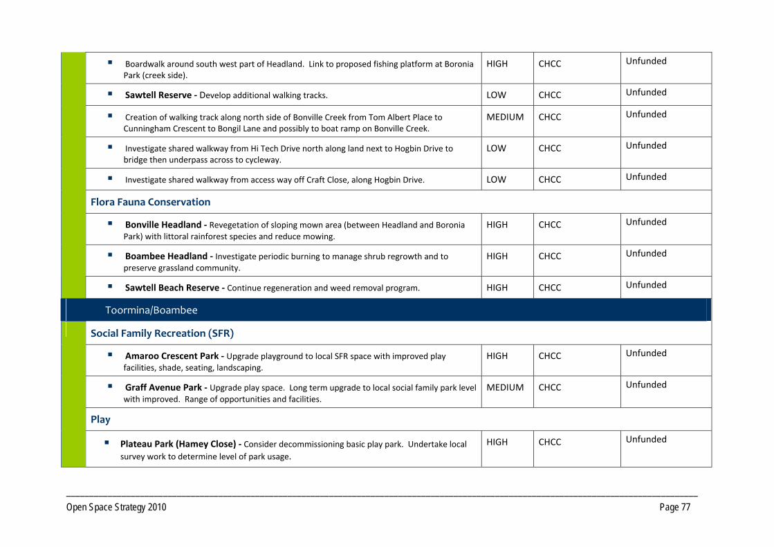
_________________________________________________________________________________________________________________________________________ Open Space Strategy 2010 Page 77
Boardwalk around south west part of Headland. Link to proposed fishing platform at Boronia Park (creek side).
HIGH CHCC Unfunded
Sawtell Reserve ‐ Develop additional walking tracks. LOW CHCC Unfunded
Creation of walking track along north side of Bonville Creek from Tom Albert Place to Cunningham Crescent to Bongil Lane and possibly to boat ramp on Bonville Creek.
MEDIUM CHCC Unfunded
Investigate shared walkway from Hi Tech Drive north along land next to Hogbin Drive to bridge then underpass across to cycleway.
LOW CHCC Unfunded
Investigate shared walkway from access way off Craft Close, along Hogbin Drive. LOW CHCC Unfunded
Flora Fauna Conservation
Bonville Headland ‐ Revegetation of sloping mown area (between Headland and Boronia Park) with littoral rainforest species and reduce mowing.
HIGH CHCC Unfunded
Boambee Headland ‐ Investigate periodic burning to manage shrub regrowth and to preserve grassland community.
HIGH CHCC Unfunded
Sawtell Beach Reserve ‐ Continue regeneration and weed removal program. HIGH CHCC Unfunded
Toormina/Boambee
Social Family Recreation (SFR)
Amaroo Crescent Park ‐ Upgrade playground to local SFR space with improved play facilities, shade, seating, landscaping.
HIGH CHCC Unfunded
Graff Avenue Park ‐ Upgrade play space. Long term upgrade to local social family park level with improved. Range of opportunities and facilities.
MEDIUM CHCC Unfunded
Play
Plateau Park (Hamey Close) ‐ Consider decommissioning basic play park. Undertake local survey work to determine level of park usage.
HIGH CHCC Unfunded
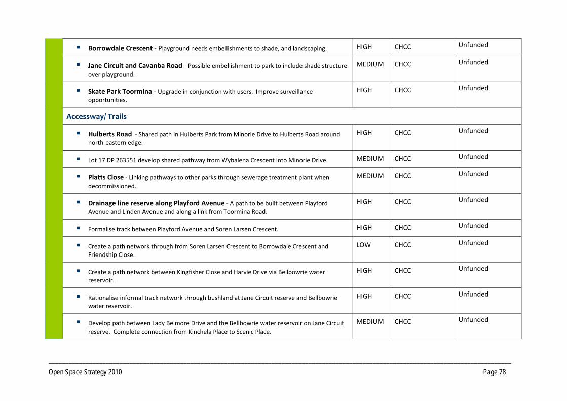
_________________________________________________________________________________________________________________________________________ Open Space Strategy 2010 Page 78
Borrowdale Crescent ‐ Playground needs embellishments to shade, and landscaping. HIGH CHCC Unfunded
Jane Circuit and Cavanba Road ‐ Possible embellishment to park to include shade structure over playground.
MEDIUM CHCC Unfunded
Skate Park Toormina ‐ Upgrade in conjunction with users. Improve surveillance opportunities.
HIGH CHCC Unfunded
Accessway/ Trails
Hulberts Road ‐ Shared path in Hulberts Park from Minorie Drive to Hulberts Road around north‐eastern edge.
HIGH CHCC Unfunded
Lot 17 DP 263551 develop shared pathway from Wybalena Crescent into Minorie Drive. MEDIUM CHCC Unfunded
Platts Close ‐ Linking pathways to other parks through sewerage treatment plant when decommissioned.
MEDIUM CHCC Unfunded
Drainage line reserve along Playford Avenue ‐ A path to be built between Playford Avenue and Linden Avenue and along a link from Toormina Road.
HIGH CHCC Unfunded
Formalise track between Playford Avenue and Soren Larsen Crescent. HIGH CHCC Unfunded
Create a path network through from Soren Larsen Crescent to Borrowdale Crescent and Friendship Close.
LOW CHCC Unfunded
Create a path network between Kingfisher Close and Harvie Drive via Bellbowrie water reservoir.
HIGH CHCC Unfunded
Rationalise informal track network through bushland at Jane Circuit reserve and Bellbowrie water reservoir.
HIGH CHCC Unfunded
Develop path between Lady Belmore Drive and the Bellbowrie water reservoir on Jane Circuit reserve. Complete connection from Kinchela Place to Scenic Place.
MEDIUM CHCC Unfunded
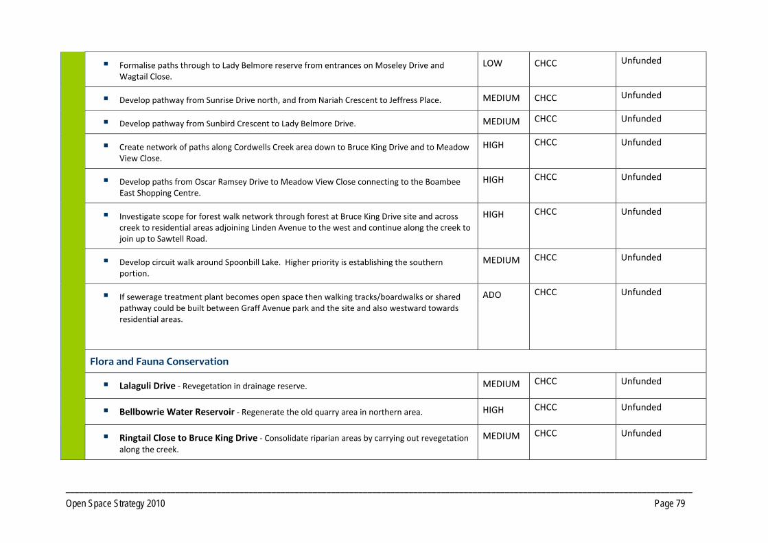
_________________________________________________________________________________________________________________________________________ Open Space Strategy 2010 Page 79
Formalise paths through to Lady Belmore reserve from entrances on Moseley Drive and Wagtail Close.
LOW CHCC Unfunded
Develop pathway from Sunrise Drive north, and from Nariah Crescent to Jeffress Place. MEDIUM CHCC Unfunded
Develop pathway from Sunbird Crescent to Lady Belmore Drive. MEDIUM CHCC Unfunded
Create network of paths along Cordwells Creek area down to Bruce King Drive and to Meadow View Close.
HIGH CHCC Unfunded
Develop paths from Oscar Ramsey Drive to Meadow View Close connecting to the Boambee East Shopping Centre.
HIGH CHCC Unfunded
Investigate scope for forest walk network through forest at Bruce King Drive site and across creek to residential areas adjoining Linden Avenue to the west and continue along the creek to join up to Sawtell Road.
HIGH CHCC Unfunded
Develop circuit walk around Spoonbill Lake. Higher priority is establishing the southern portion.
MEDIUM CHCC Unfunded
If sewerage treatment plant becomes open space then walking tracks/boardwalks or shared pathway could be built between Graff Avenue park and the site and also westward towards residential areas.
ADO CHCC Unfunded
Flora and Fauna Conservation
Lalaguli Drive ‐ Revegetation in drainage reserve. MEDIUM CHCC Unfunded
Bellbowrie Water Reservoir ‐ Regenerate the old quarry area in northern area. HIGH CHCC Unfunded
Ringtail Close to Bruce King Drive ‐ Consolidate riparian areas by carrying out revegetation along the creek.
MEDIUM CHCC Unfunded

_________________________________________________________________________________________________________________________________________ Open Space Strategy 2010 Page 80
Reserve which begins where Linden Avenue meets Toormina Road ‐ Carry out revegetation works under existing planted eucalypts. Investigate possible need to remove some eucalypts. Create a better wildlife corridor.
HIGH CHCC Unfunded
Manage environmental degradation Boambee Creek, west of Hogbin Drive. Consider installation of fishing platforms to manage erosion.
HIGH CHCC Unfunded
Bruce King Drive ‐ Regeneration and weed control SEPP 14 and Cordwells Creek. HIGH CHCC Unfunded
Spoonbill Lake ‐ Desilting and weed control.
HIGH CHCC Unfunded
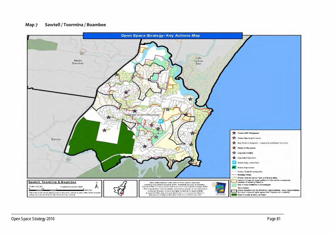
_________________________________________________________________________________________________________________________________________ Open Space Strategy 2010 Page 81
Map 7 Sawtell / Toormina / Boambee
_________________________________________________________________________________________________________________________________________ Open Space Strategy 2010 Page 82
PRECINCT 8 Bonville
8.1 Precinct Recommendations
Objective 8.1.1 Provide additional open space opportunities
Actions Open Space for social and family recreation that includes play for children and young people must be considered in the development plans for the future neighbourhoods.
Develop an equestrian area on the southern end of the Bakker Drive Reserve. Longer term consider the need for amenities and car parking. Develop future access via North Bonville Road and Braford Drive in conjunction with any redevelopment. Reserve to retain multi‐use capability. Consider leasing of equestrian area to the Bonville Valley Riding Club, ensuring any lease arrangement reflects multiuse principles.
Formalise public access arrangements in conjunction with any redevelopment of land to the west of Bakker Road Reserve to create bridle and access paths to nearby State Forest trail network. Also investigate opportunities to develop linkages via North Bonville Road and the Crown Road network, to the Tuckers Nob, Boambee and Orara West State Forests. Investigate need to upgrade footbridge.
Objective 8.1.2 Provide additional Open Space required to service new development
Actions Investigate the acquisition of land for a district level sports facility that provides for major participation sports in Bonville in line with the
expected population growth that is planned for the neighbourhood.
Additional open space for Local Social Family Recreation, Access way/trails and Local Sport as per Core Service Levels criteria within areas identified for Short Term future residential expansion, as identified in Council's current growth strategies. Location and number of spaces to be determined in conjunction with detailed land planning.
Additional Open Space for a range of functions including Local Social Family Recreation, Amenity Parkland, Access way/ trails and Local/District Sport as per Core Service Levels criteria within areas identified, long term, for residential expansion (future Bonville Township), identified in Council's current growth strategies. Location and number of spaces to be determined in conjunction with detailed land planning processes.
PRECINCT 8 Bonville
_________________________________________________________________________________________________________________________________________ Open Space Strategy 2010 Page 83
Pursue where practical the dedication, as public Open Space, of key lands forming habitat and/or corridor functions that will add value to existing open space in conjunction with any residential development of lands. Encourage dedication at no cost to Council.
8.2 Park Improvement Program
8.2.1 District Open Space Priority Responsibility Status
Bakker Drive ‐ Develop the southern end of the Bakker Drive Reserve for equestrian use. HIGH CHCC Unfunded
8.2.2 Local Open Space
Accessway/Trails
Formalise public access arrangements through private land to the west of Bakker Road Reserve to create bridle paths to the nearby State Forest trail network. Alignment of route to be reviewed in context of adjoining development when it proceeds.
HIGH CHCC Unfunded
Bakker Drive Reserve ‐ Develop circuit walking trails. LOW CHCC Unfunded
Flora Fauna Conservation
Bakker Drive Reserve ‐ Regeneration of riparian area in conjunction with local Landcare group.
HIGH CHCC Unfunded
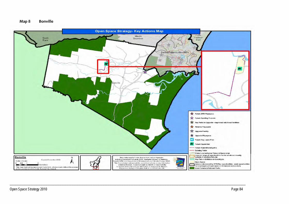
_________________________________________________________________________________________________________________________________________ Open Space Strategy 2010 Page 84
Map 8 Bonville
_________________________________________________________________________________________________________________________________________ Open Space Strategy 2010 Page 85
PRECINCT 9 Far North Rural
9.1 Precinct Recommendations
Objective 9.1.1 Provide additional open space opportunities
Actions Investigate community demand for a local sports/recreation reserve, within this precinct, that has a perimeter trail and provides for social and family
recreation.
No additional open space is immediately required within this precinct. However, this is subject to further community consultation to determine needs.
PRECINCT 9 Far North Rural
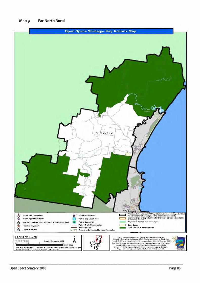
_______________________________________________________________________________________________________ Open Space Strategy 2010 Page 86
Map 9 Far North Rural
________________________________________________________________________________________________________________________________________ Open Space Strategy 2010 Page 87
PRECINCT 10 North Rural
10.1 Precinct Recommendations
Objective 10.1.1 Provide additional open space opportunities
Actions Retain focus of the Nana Glen Sport and Recreation Grounds as a venue for equestrian pursuits.
Investigate community interest in refurbishment of the Tennis Courts as a multi purpose facility.
Investigate opportunities for public use of the Nana Glen School’s recreation facilities.
Explore opportunities to develop a nature trail utilising the Sportsground to connect Nana Glen and Nana Glen Rail.
No additional open space is required within this Precinct as there is sufficient scope for redevelopment of existing open pace to service current and planned future populations as per Council's current growth strategy.
10.2 Park Improvement Program
10.2.1 District Open Space Priority Responsibility Status
Sport
Prepare Master Plan for the Nana Glen Sport and Recreation Ground.
Development of additional facilities supporting equestrian pursuits at Nana Glen Sport and Recreation Ground.
MEDIUM CHCC Unfunded
PRECINCT 10 North Rural
________________________________________________________________________________________________________________________________________ Open Space Strategy 2010 Page 88
10.2.2 Local Open Space
Social Family Recreation (SFR)
Archie Hunter Reserve ‐ Develop a nature based junior playground. MEDIUM CHCC Unfunded
Play
Bucca Sports Reserve ‐ Development of a playground. LOW LPMA/Reserve Trust
Consult with Reserve managers regarding the need for works. Unfunded
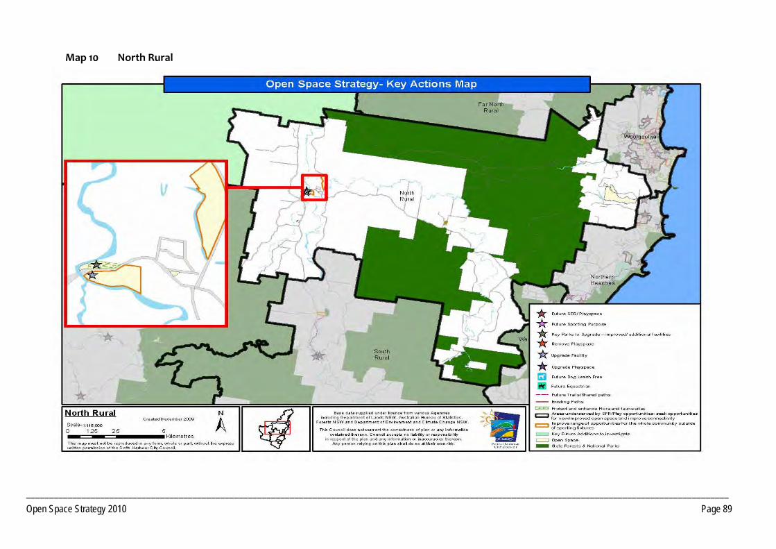
________________________________________________________________________________________________________________________________________________________ Open Space Strategy 2010 Page 89
Map 10 North Rural
_________________________________________________________________________________________________________________________________________ Open Space Strategy 2010 Page 90
PRECINCT 11 South Rural
11.1 Precinct Recommendations
Objective 11.1.1 Provide additional open space opportunities
Actions Investigate need for a tennis facility at Coramba and identify suitable sites.
Ensure zoning of land surrounding the Pistol Club, Mount Browne Road, is compatible with that sport to ensure continuation of Pistol Club.
Opportunities to access open space for social and family recreation and play for children and young people must be considered in the development plans for the areas.
Investigate opportunities for public use of Coramba School’s recreation facilities.
Investigate opportunities for an off road path connection between Coramba and the Sportsground, ideally along the Orara River.
PRECINCT 11 South Rural
_________________________________________________________________________________________________________________________________________ Open Space Strategy 2010 Page 91
11.2 Park Improvement Program
11.2.1 Local Open Space Priority Responsibility Status
Play
CWA Park, Coramba ‐ Enhance play space and refurbish amenities for day use, so to encourage way‐side stop use. Investigate feasibility of a BBQ at this location.
MEDIUM CHCC Unfunded
Thrower Avenue, Coramba ‐ Undertake drainage and fill works and develop BMX, adventure playground, hard court and games area on land parcel at Thrower Avenue. Determine other appropriate play experiences that could be provided on flood prone site.
HIGH CHCC Unfunded
Water Based Recreation
Martin Street park ‐ Investigate options to pull back car parking from river edge and develop as a picnic area pending flooding constraints.
MEDIUM CHCC Unfunded
Accessway/Trails
Future shared path connection from Coramba village to the Showground (creek line route or main road).
LOW CHCC Unfunded
Coramba ‐ Develop connection from Coramba Hotel to Thrower Avenue Reserve. HIGH CHCC Unfunded
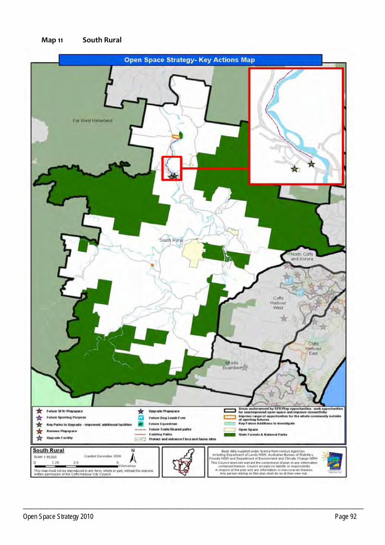
_________________________________________________________________________________________________________ Open Space Strategy 2010 Page 92
Map 11 South Rural

_________________________________________________________________________________________________________________________________________ Open Space Strategy 2010 Page 93
PRECINCT 12 Far West Hinterland
12.1 Precinct Recommendations
Objective 12.1.1 Providing for current and future Open Space needs
Actions Ulong ‐ To provide a play space within a social and family recreation space is a priority. The demographic indicates demand for more play opportunities for children and young people with a high number of families residing in the precinct.
Investigate level of community interest in upgrading tennis court’s to a multi purpose hardcourt facility.
No additional open space is required within this Precinct as there is sufficient scope for redevelopment of existing open pace to service current and planned future populations as per Council's current growth strategy.
Lowanna and Ulong ‐ Off road trails should be considered that connect recreation opportunities, the school and shop.
12.2 Park Improvement Program
12.2.1 Local Open Space Priority Responsibility Status
Play
Ulong Showground ‐ Develop play (including BMX) facilities catering for wide age ranges. HIGH CHCC Unfunded
Lowanna Reserve ‐ Development of a playground and facilities for adolescents. MEDIUM CHCC Unfunded
Social Family Recreation
Timms Park ‐ Additional seating, develop onsite interpretation. LOW CHCC Unfunded
PRECINCT 12 Far West Hinterland
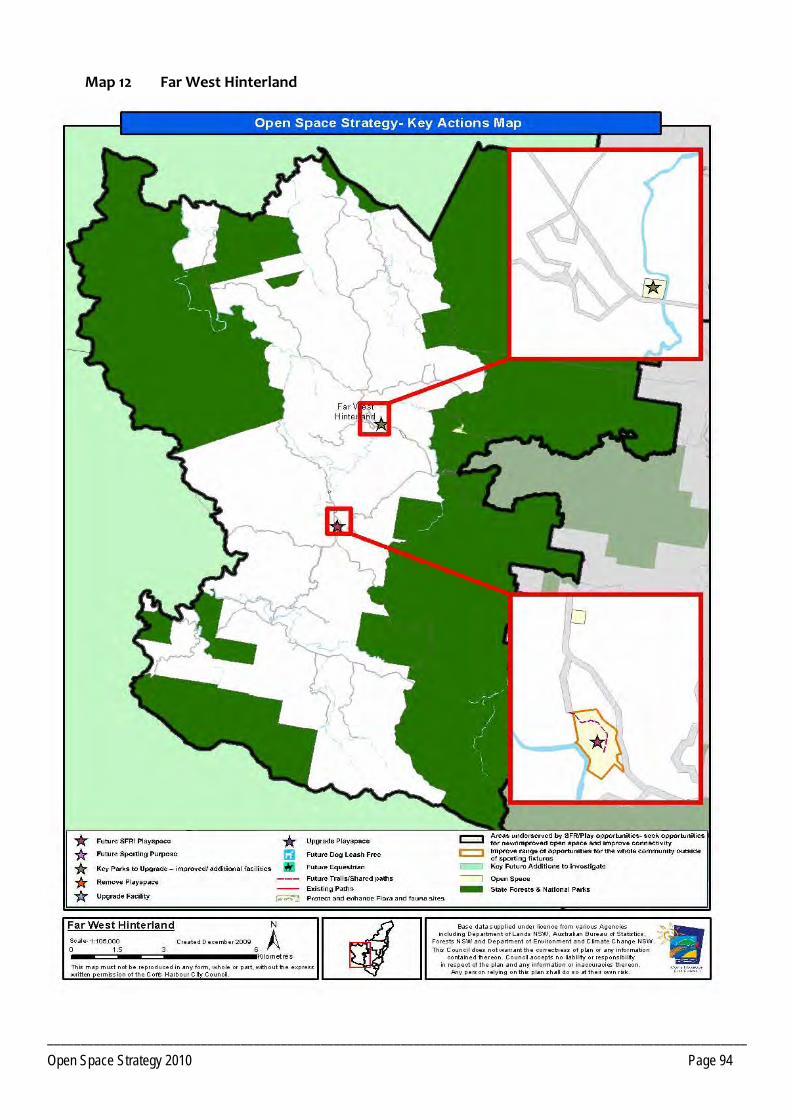
_________________________________________________________________________________________________________ Open Space Strategy 2010 Page 94
Map 12 Far West Hinterland
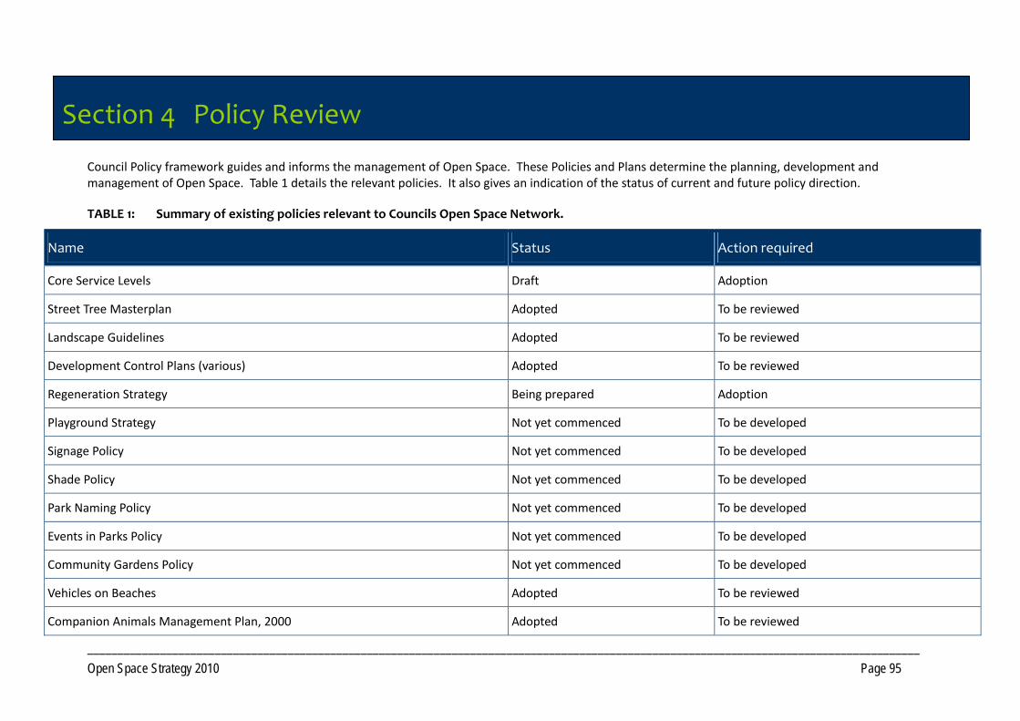
_________________________________________________________________________________________________________________________________________ Open Space Strategy 2010 Page 95
Section 4 Policy Review
Council Policy framework guides and informs the management of Open Space. These Policies and Plans determine the planning, development and management of Open Space. Table 1 details the relevant policies. It also gives an indication of the status of current and future policy direction.
TABLE 1: Summary of existing policies relevant to Councils Open Space Network.
Name Status Action required
Core Service Levels Draft Adoption
Street Tree Masterplan Adopted To be reviewed
Landscape Guidelines Adopted To be reviewed
Development Control Plans (various) Adopted To be reviewed
Regeneration Strategy Being prepared Adoption
Playground Strategy Not yet commenced To be developed
Signage Policy Not yet commenced To be developed
Shade Policy Not yet commenced To be developed
Park Naming Policy Not yet commenced To be developed
Events in Parks Policy Not yet commenced To be developed
Community Gardens Policy Not yet commenced To be developed
Vehicles on Beaches Adopted To be reviewed
Companion Animals Management Plan, 2000 Adopted To be reviewed
Section 4 Policy Review
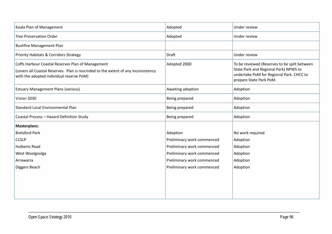
_________________________________________________________________________________________________________________________________________ Open Space Strategy 2010 Page 96
Koala Plan of Management Adopted Under review
Tree Preservation Order Adopted Under review
Bushfire Management Plan
Priority Habitats & Corridors Strategy Draft Under review
Coffs Harbour Coastal Reserves Plan of Management
(covers all Coastal Reserves. Plan is rescinded to the extent of any inconsistency with the adopted individual reserve PoM)
Adopted 2000 To be reviewed (Reserves to be split between State Park and Regional Park) NPWS to undertake PoM for Regional Park. CHCC to prepare State Park PoM.
Estuary Management Plans (various) Awaiting adoption Adoption
Vision 2030 Being prepared Adoption
Standard Local Environmental Plan Being prepared Adoption
Coastal Process – Hazard Definition Study Being prepared Adoption
Masterplans:
Brelsford Park
CCSLP
Hulberts Road
West Woolgoolga
Arrawarra
Diggers Beach
Adoption
Preliminary work commenced
Preliminary work commenced
Preliminary work commenced
Preliminary work commenced
Preliminary work commenced
No work required
Adoption
Adoption
Adoption
Adoption
Adoption
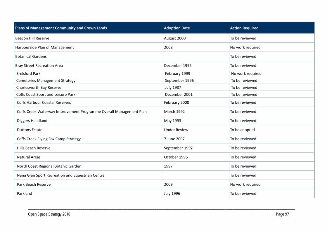
_________________________________________________________________________________________________________________________________________ Open Space Strategy 2010 Page 97
Plans of Management Community and Crown Lands Adoption Date Action Required
Beacon Hill Reserve August 2000 To be reviewed
Harbourside Plan of Management 2008 No work required
Botanical Gardens To be reviewed
Bray Street Recreation Area December 1995 To be reviewed
Brelsford Park February 1999 No work required
Cemeteries Management Strategy September 1996 To be reviewed
Charlesworth Bay Reserve July 1987 To be reviewed
Coffs Coast Sport and Leisure Park December 2001 To be reviewed
Coffs Harbour Coastal Reserves February 2000 To be reviewed
Coffs Creek Waterway Improvement Programme Overall Management Plan March 1992 To be reviewed
Diggers Headland May 1993 To be reviewed
Duttons Estate Under Review To be adopted
Coffs Creek Flying Fox Camp Strategy 7 June 2007 To be reviewed
Hills Beach Reserve September 1992 To be reviewed
Natural Areas October 1996 To be reviewed
North Coast Regional Botanic Garden 1997 To be reviewed
Nana Glen Sport Recreation and Equestrian Centre To be reviewed
Park Beach Reserve 2009 No work required
Parkland July 1996 To be reviewed

_________________________________________________________________________________________________________________________________________ Open Space Strategy 2010 Page 98
Picnic Areas October 1996 To be reviewed
Playgrounds October 1996 To be reviewed
Sawtell Reserve 2009 No work required
Solitary Islands Coastal Walk Strategy February 2000 To be reviewed
Sportsground October 1996 To be reviewed
Woolgoolga Community Centre December 1999 To be reviewed
Woolgoolga Lake and Lake Reserves 1992 To be reviewed
Woolgoolga Swimming Pool and Recreation Reserve July 2000 To be reviewed