Embed Size (px)
Citation preview
DC GIS Steering Committee MeetingJune 7, 2007
Barney KrucoffGIS Director
Office of The Chief Technology [email protected]
202-727-9307

Agenda– Introductions – Barney Krucoff
– DC GIS News – Barney Krucoff
– System update – Zhen Lo
– Data Report – Mario Field
– Training Report – Tim Abdella
– Income Data from OCFO – Kelly Dinkins and Fitzroy Lee
– DC WASA Asset Identification – Louis Desjardins

News Items
• ESRI Enterprise License (Back at the table)
• United States Geological Survey Planning Grant– not this year
• Regional GIS News– COG data exchange HUB (DOH)
• DC GIS showcase with WDCEP in Vegas
• ESRI User Conference June 18 – 22– Any items to address with ESRI or community?
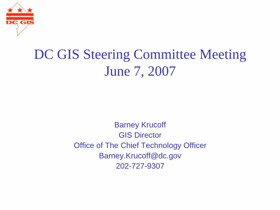
New Administrative Projects
– Mayor’s Transparency Web Site– Department of Environment– MPD Reporting Forms– Nuisance Property Task Force– Office of Property Management web site– Economic Development Cluster Focus on housing data– WASA & FEMS Fire Hydrants – DDOT
• Asset Management• Various Permitting Applications• Vending
– DCRA• Permitting• Vending
DC GIS Systems Report
Zhen Lo
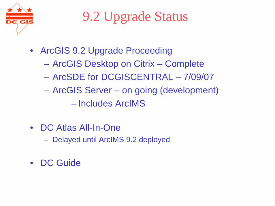
9.2 Upgrade Status
• ArcGIS 9.2 Upgrade Proceeding– ArcGIS Desktop on Citrix – Complete– ArcSDE for DCGISCENTRAL – 7/09/07– ArcGIS Server – on going (development)
– Includes ArcIMS
• DC Atlas All-In-One– Delayed until ArcIMS 9.2 deployed
• DC Guide
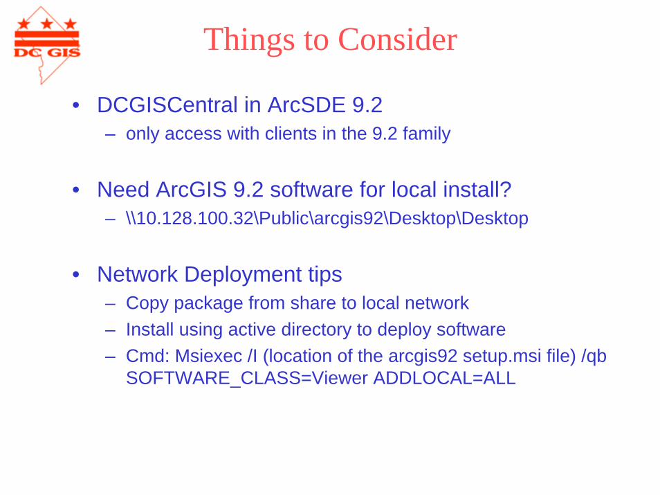
Things to Consider
• DCGISCentral in ArcSDE 9.2– only access with clients in the 9.2 family
• Need ArcGIS 9.2 software for local install?– \\10.128.100.32\Public\arcgis92\Desktop\Desktop
• Network Deployment tips– Copy package from share to local network– Install using active directory to deploy software– Cmd: Msiexec /I (location of the arcgis92 setup.msi file) /qb
SOFTWARE_CLASS=Viewer ADDLOCAL=ALL
DC GIS Data Report
Mario FieldDr. Data
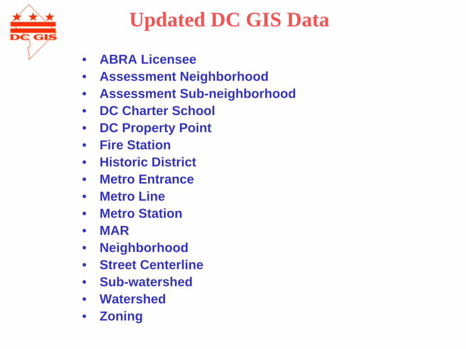
Updated DC GIS Data
• ABRA Licensee• Assessment Neighborhood• Assessment Sub-neighborhood• DC Charter School• DC Property Point• Fire Station• Historic District• Metro Entrance• Metro Line• Metro Station• MAR• Neighborhood• Street Centerline• Sub-watershed • Watershed• Zoning
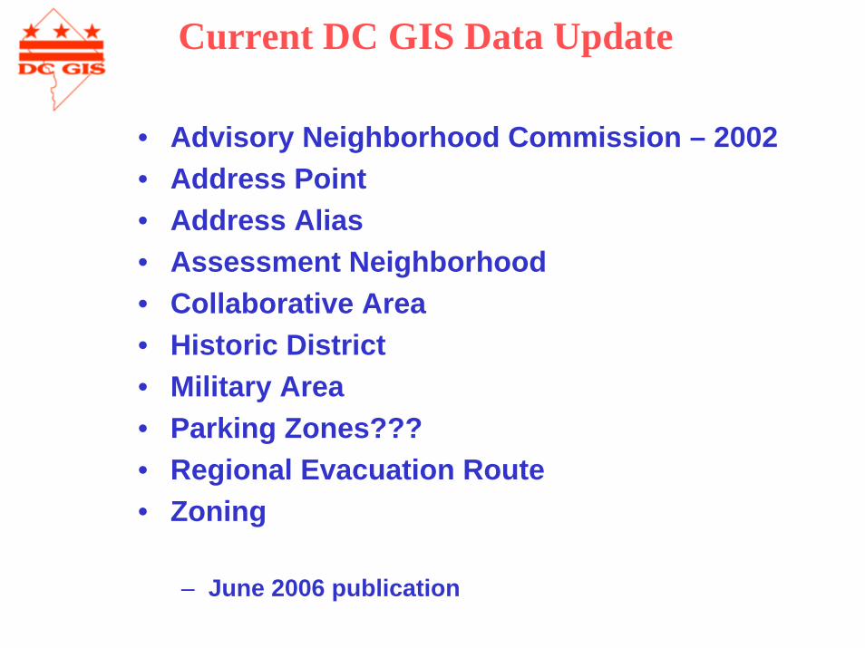
• Advisory Neighborhood Commission – 2002• Address Point• Address Alias• Assessment Neighborhood• Collaborative Area• Historic District• Military Area• Parking Zones???• Regional Evacuation Route• Zoning
– June 2006 publication
Current DC GIS Data Update
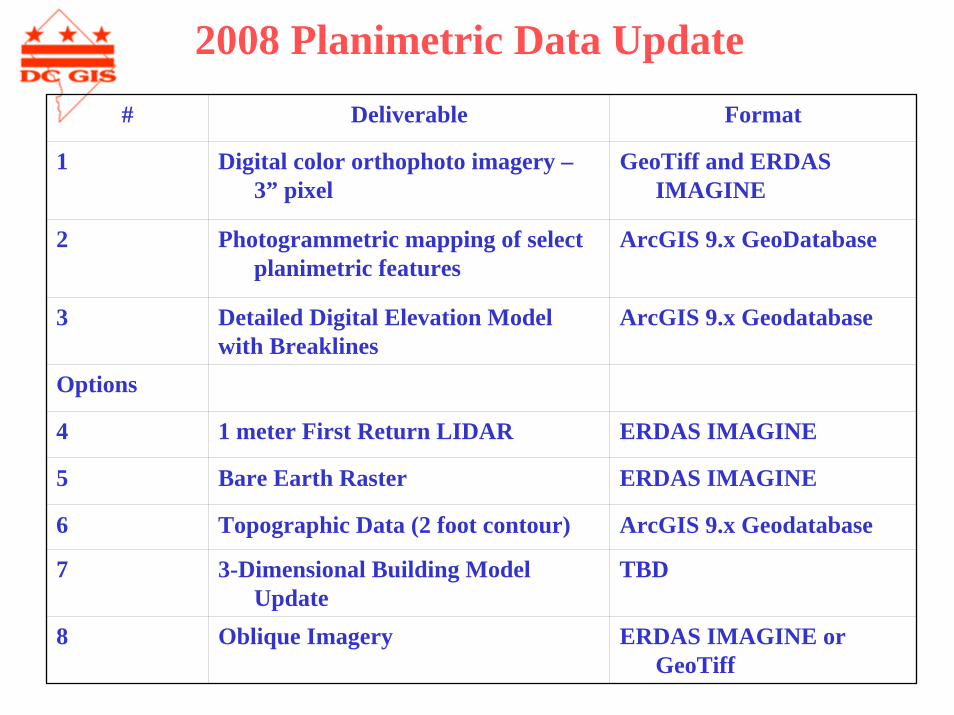
2008 Planimetric Data Update# Deliverable Format
1 Digital color orthophoto imagery –3” pixel
GeoTiff and ERDAS IMAGINE
2 Photogrammetric mapping of select planimetric features
ArcGIS 9.x GeoDatabase
3 Detailed Digital Elevation Model with Breaklines
ArcGIS 9.x Geodatabase
Options
4 1 meter First Return LIDAR ERDAS IMAGINE
5 Bare Earth Raster ERDAS IMAGINE
6 Topographic Data (2 foot contour) ArcGIS 9.x Geodatabase
7 3-Dimensional Building Model Update
TBD
8 Oblique Imagery ERDAS IMAGINE or GeoTiff
2008 Planimetric Data Update
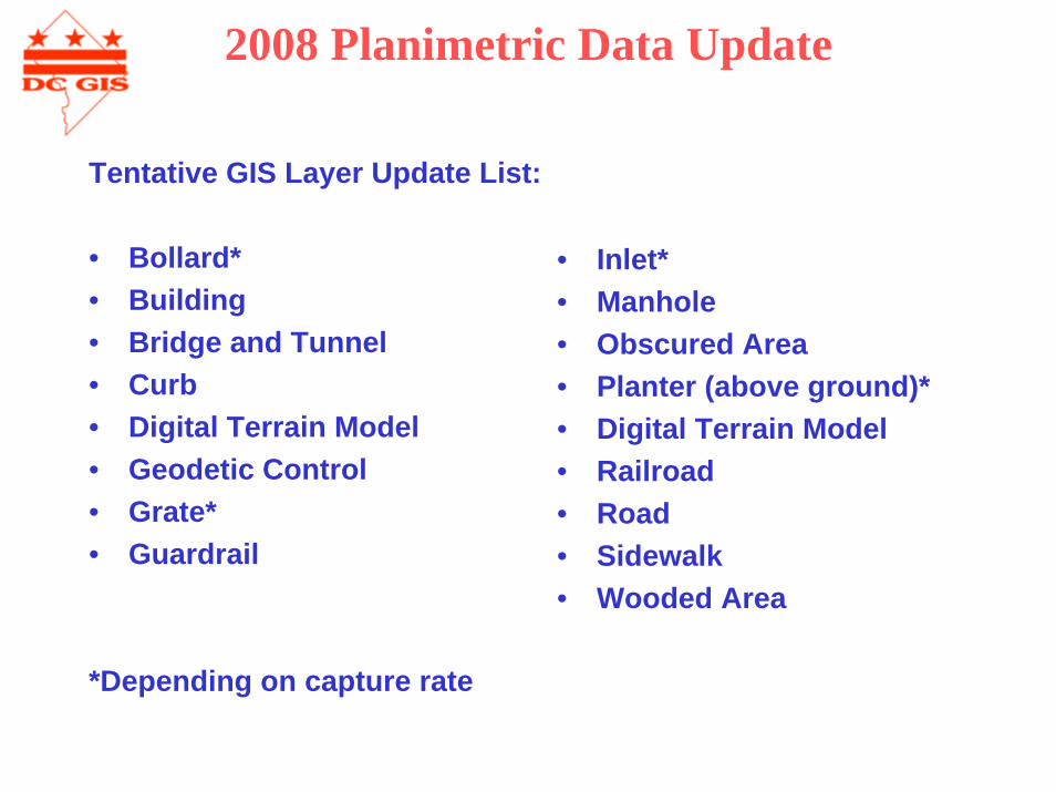
Tentative GIS Layer Update List:
• Bollard*• Building• Bridge and Tunnel• Curb• Digital Terrain Model• Geodetic Control• Grate*• Guardrail
*Depending on capture rate
• Inlet*• Manhole• Obscured Area• Planter (above ground)*• Digital Terrain Model• Railroad• Road• Sidewalk• Wooded Area

DC GIS Training Report
Tim AbdellaGeoSpatial Education Director
CWD Courses
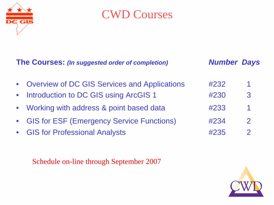
The Courses: (In suggested order of completion) Number Days
• Overview of DC GIS Services and Applications #232 1• Introduction to DC GIS using ArcGIS 1 #230 3
• Working with address & point based data #233 1
• GIS for ESF (Emergency Service Functions) #234 2• GIS for Professional Analysts #235 2
Schedule on-line through September 2007

CWD Registration
Course Registration:
• Select Classes• Get Supervisor Approval• Complete the Training Form• E-mail to Training Coordinator for his/her review and signature• Confirmation of enrollment in the course will be emailed to you• Notify CWD if you can not attend within 3 days of the class• For more information about CWD, call (202) 727-1523• All Information is on dcgis.in.dc.gov Training Website
http://www.dcop.in.dc.gov
Click on:Training and Development
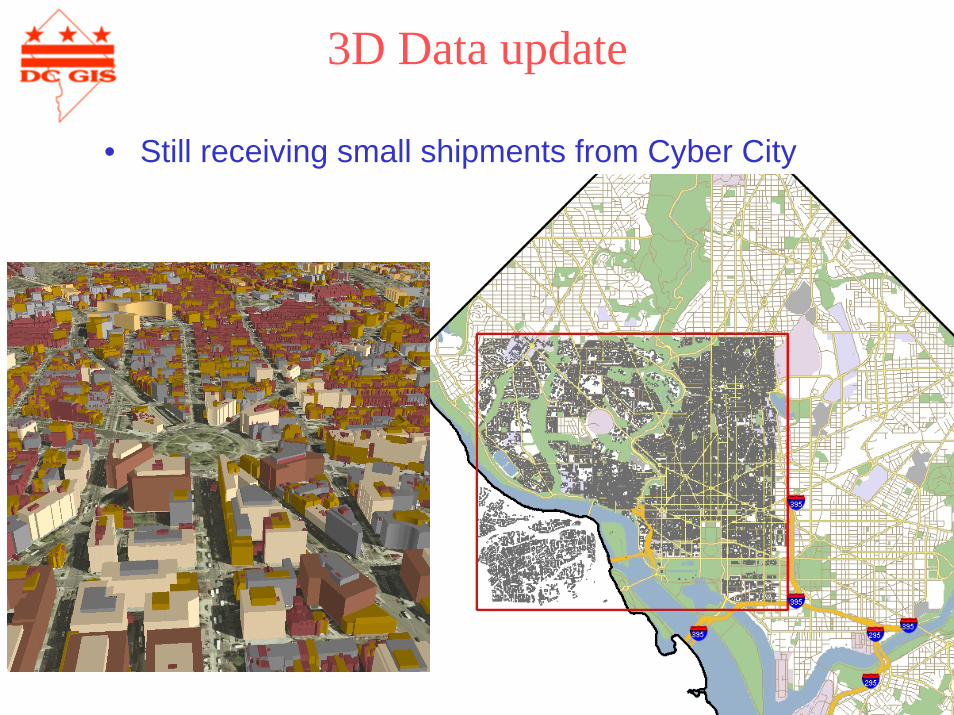
3D Data update
• Still receiving small shipments from Cyber City
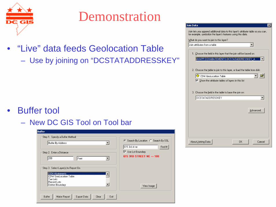
Demonstration
• “Live” data feeds Geolocation Table– Use by joining on “DCSTATADDRESSKEY”
• Buffer tool– New DC GIS Tool on Tool bar

Timothy L AbdellaGeoSpatial Education Director
Office of the Chief Technology Officer441 4th Street, NW
Washington, DC [email protected] Office716-308-0000 Cell
Q&A
Thank you
Agency Presentations
• OCFO – ORA– Income tax Data– Kelly Dinkins and Fitzroy Lee
• DC WASA– Asset Identification– Louis Desjardins
Geocoding the Individual Income Tax Data
Kelly Dinkins, Data ManagerOffice of Revenue Analysis
Office of the Chief Financial OfficerJune 7, 2007

What is ORA ?
• The Office of Revenue Analysis:Forecasts Revenue
Develops Fiscal Impact Statements
Performs Tax Expenditure Analysis
Special Research Projects
Income Tax Return Structure
• The Office of Tax and Revenue (OTR) maintains a computerized tax database as part of the Integrated Tax System (ITS)
• Information in the ITS system is accessed through the SAND querying system
• ITS has over 200 tablesTaxpayer demographics Financial transaction details for each tax form filed
• ID_Internal is a key fieldGiven to each individual or business taxpayer Represents the entity in all ITS tables Allows the tables to be joined
Income Tax Return Structure cont…
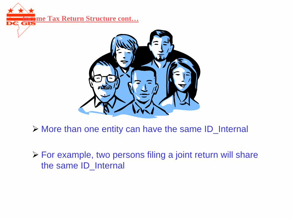
More than one entity can have the same ID_Internal
For example, two persons filing a joint return will share the same ID_Internal
Income Tax Return Structure cont…
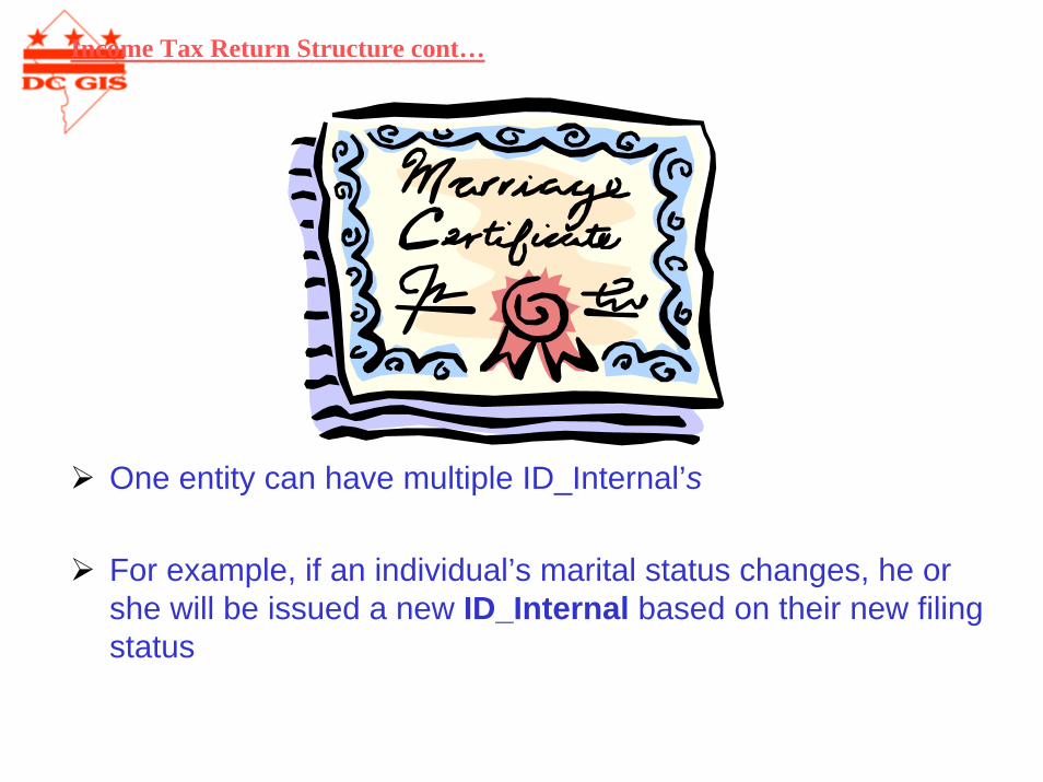
One entity can have multiple ID_Internal’s
For example, if an individual’s marital status changes, he or she will be issued a new ID_Internal based on their new filing status
Income Tax Return Structure cont…
ID_Internal does not uniquely identify a taxpayer
ID_Internal does uniquely identify a taxpayer return
ID_Internal is used to link the individual tax return table to other tables such as SSN, name and address
Income Tax Return Structure cont…
OTR Data Transfer Process
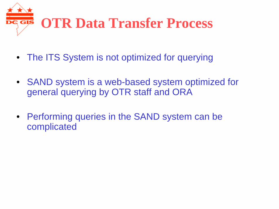
• The ITS System is not optimized for querying
• SAND system is a web-based system optimized for general querying by OTR staff and ORA
• Performing queries in the SAND system can be complicated
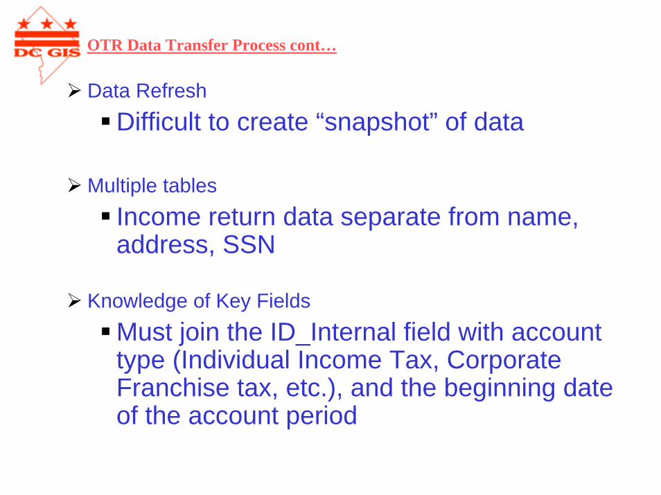
Data RefreshDifficult to create “snapshot” of data
Multiple tablesIncome return data separate from name, address, SSN
Knowledge of Key FieldsMust join the ID_Internal field with account type (Individual Income Tax, Corporate Franchise tax, etc.), and the beginning date of the account period
OTR Data Transfer Process cont…
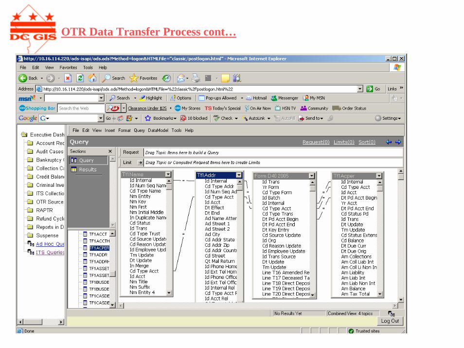
OTR Data Transfer Process cont…
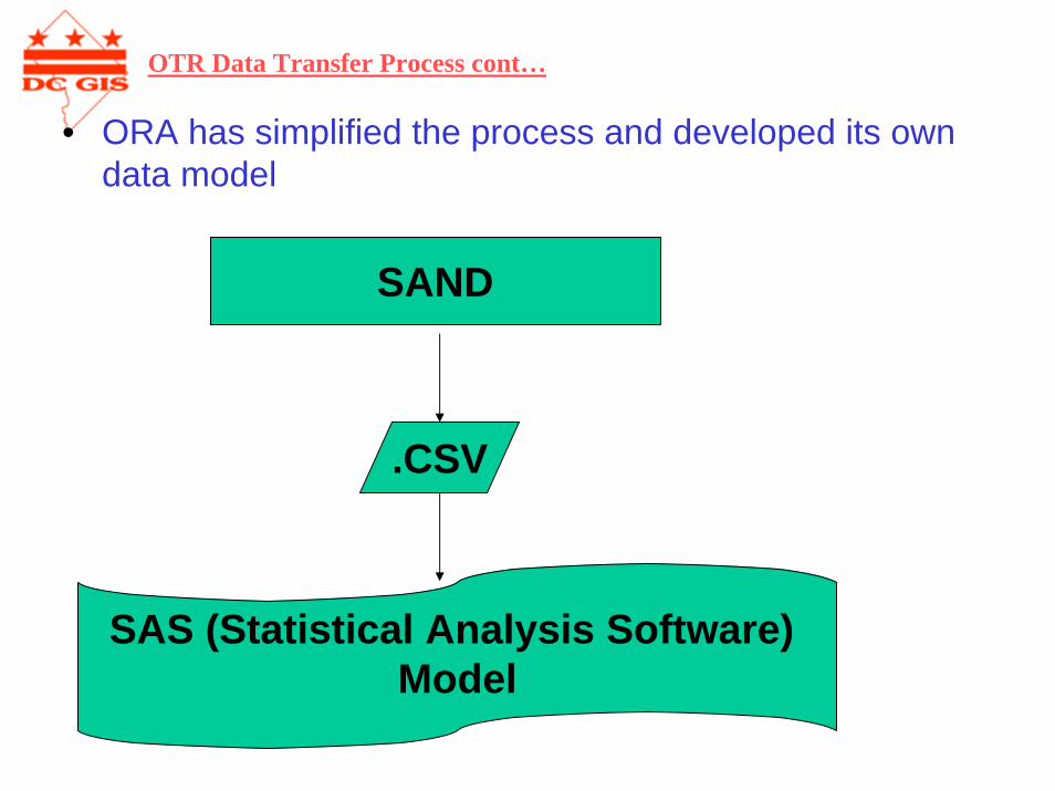
• ORA has simplified the process and developed its own data model
SAND
.CSV
SAS (Statistical Analysis Software) Model
OTR Data Transfer Process cont…
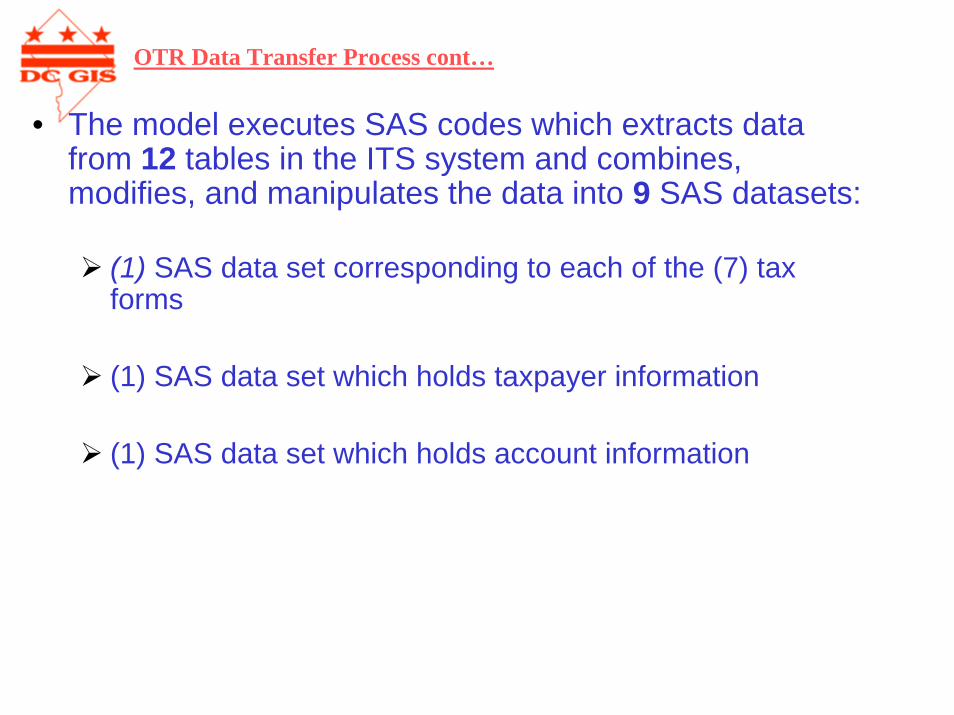
• The model executes SAS codes which extracts data from 12 tables in the ITS system and combines, modifies, and manipulates the data into 9 SAS datasets:
(1) SAS data set corresponding to each of the (7) tax forms
(1) SAS data set which holds taxpayer information
(1) SAS data set which holds account information
OTR Data Transfer Process cont…
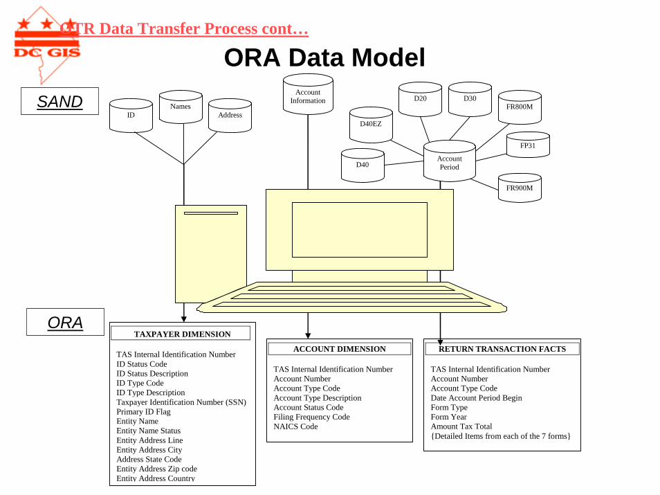
ORA Data ModelOTR Data Transfer Process cont…
ORA
SAND
TAXPAYER DIMENSION TAS Internal Identification Number ID Status Code ID Status Description ID Type Code ID Type Description Taxpayer Identification Number (SSN) Primary ID Flag Entity Name Entity Name Status Entity Address Line Entity Address City Address State Code Entity Address Zip code Entity Address Country
ACCOUNT DIMENSION TAS Internal Identification Number Account Number Account Type Code Account Type Description Account Status Code Filing Frequency Code NAICS Code
RETURN TRANSACTION FACTS TAS Internal Identification Number Account Number Account Type Code Date Account Period Begin Form Type Form Year Amount Tax Total {Detailed Items from each of the 7 forms}
Account Information
ID Names
Address D40EZ
D20 D30
D40
FR800M
FP31
Account Period
FR900M
Geocoding Process• Reasons for geocoding were twofold:
1) Policymakers oftentimes make requests that require spatial analysis
ITS system has numerous inconsistencies, discrepancies and errors in the data especially with respect to names and addresses
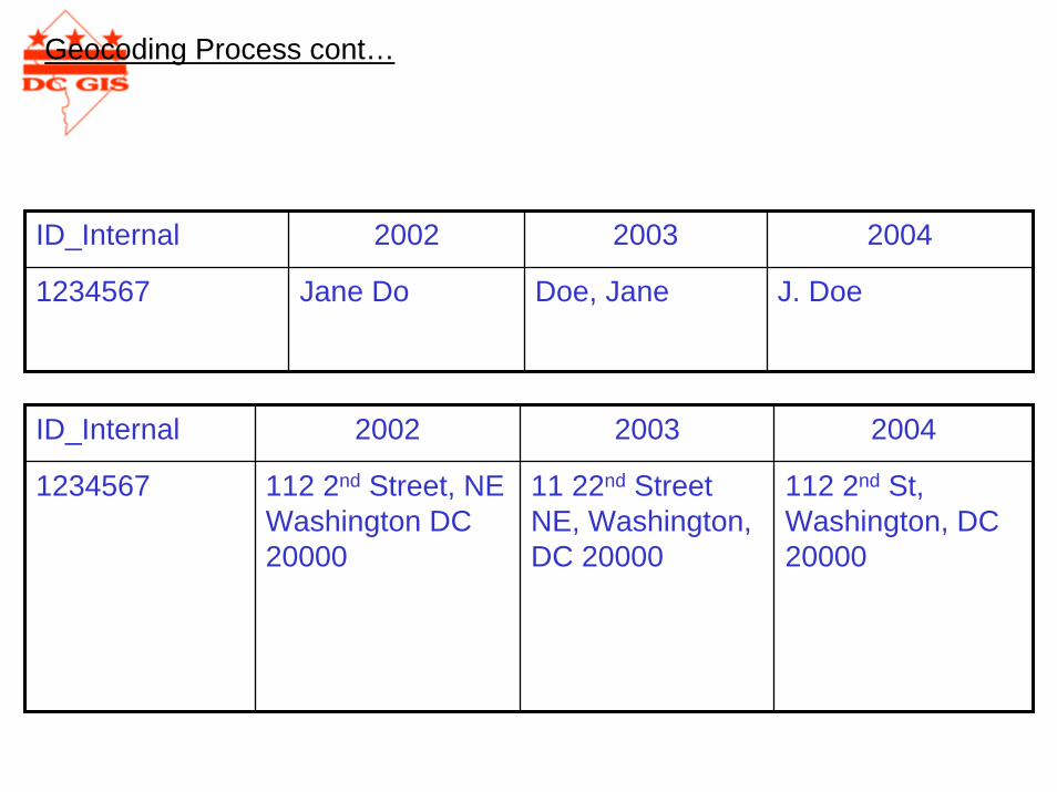
ID_Internal 2002 2003 2004
1234567 Jane Do Doe, Jane J. Doe
ID_Internal 2002 2003 2004
112 2nd St, Washington, DC 20000
1234567 112 2nd Street, NE Washington DC 20000
11 22nd Street NE, Washington, DC 20000
Geocoding Process cont…
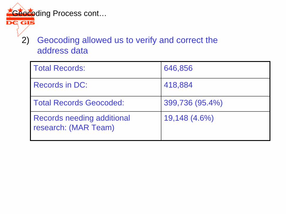
2) Geocoding allowed us to verify and correct the address data
Total Records: 646,856
Records in DC: 418,884
Total Records Geocoded: 399,736 (95.4%)
Records needing additional research: (MAR Team)
19,148 (4.6%)
Geocoding Process cont…
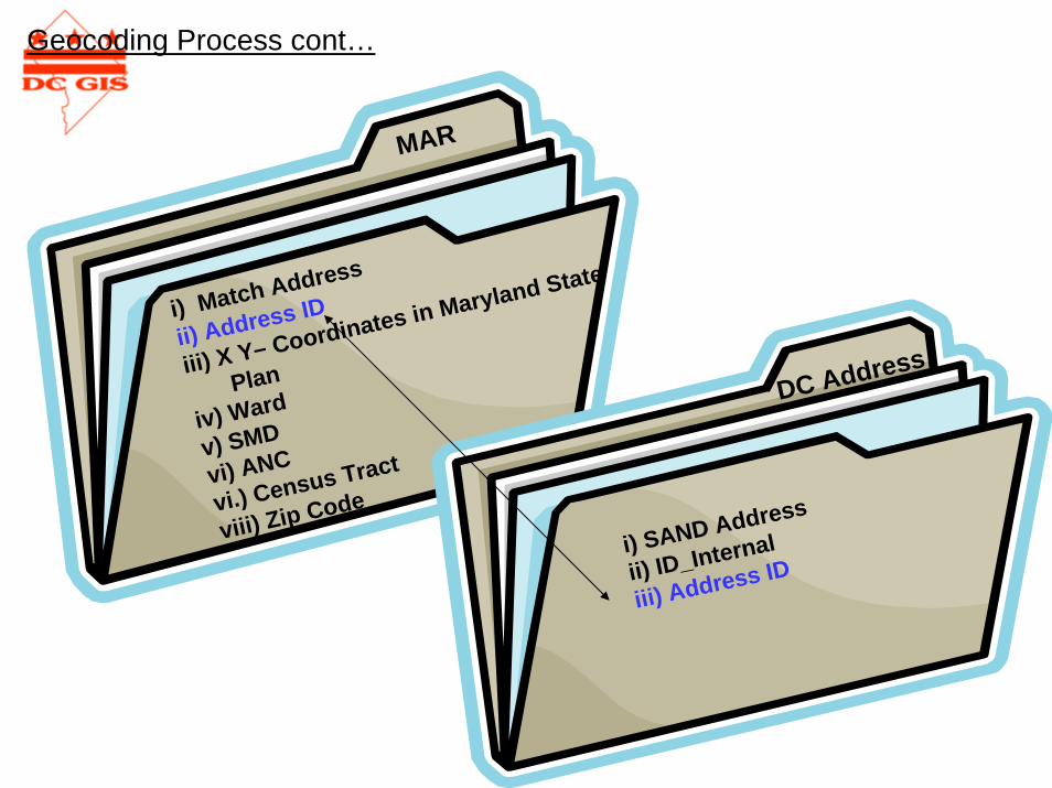
Match Address
i) MAR Address IDii) X Y– Coordinates in Maryland State Plan iv) Wardv) SMDvi) ANCvi.) Census Tractviii) Zip Code
i) Match Address
ii) Address ID
iii) X Y– Coordinates in Maryland State
Plan
iv) Ward
v) SMD
vi) ANC
vi.) Census Tract
viii) Zip Code
i) SAND Address
ii) ID_Internal
iii) Address ID
MAR
DC Address
Geocoding Process cont…
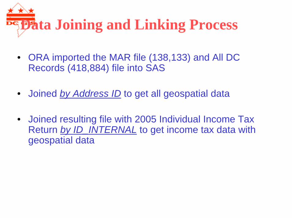
• ORA imported the MAR file (138,133) and All DC Records (418,884) file into SAS
• Joined by Address ID to get all geospatial data
• Joined resulting file with 2005 Individual Income Tax Return by ID_INTERNAL to get income tax data with geospatial data
Data Joining and Linking Process
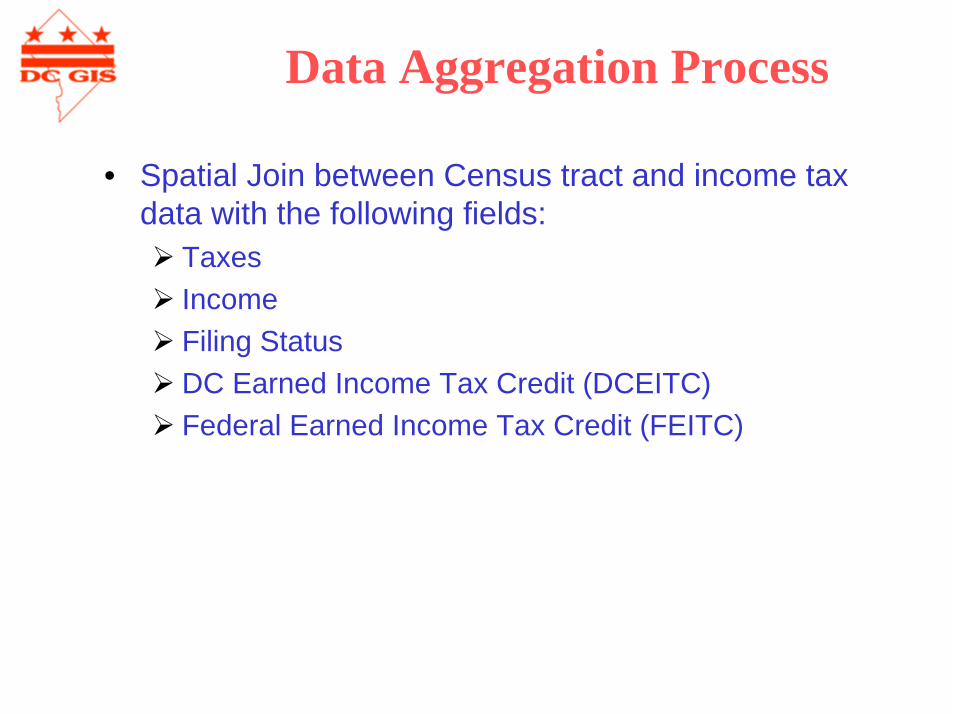
Data Aggregation Process
• Spatial Join between Census tract and income tax data with the following fields:
Taxes IncomeFiling StatusDC Earned Income Tax Credit (DCEITC)Federal Earned Income Tax Credit (FEITC)
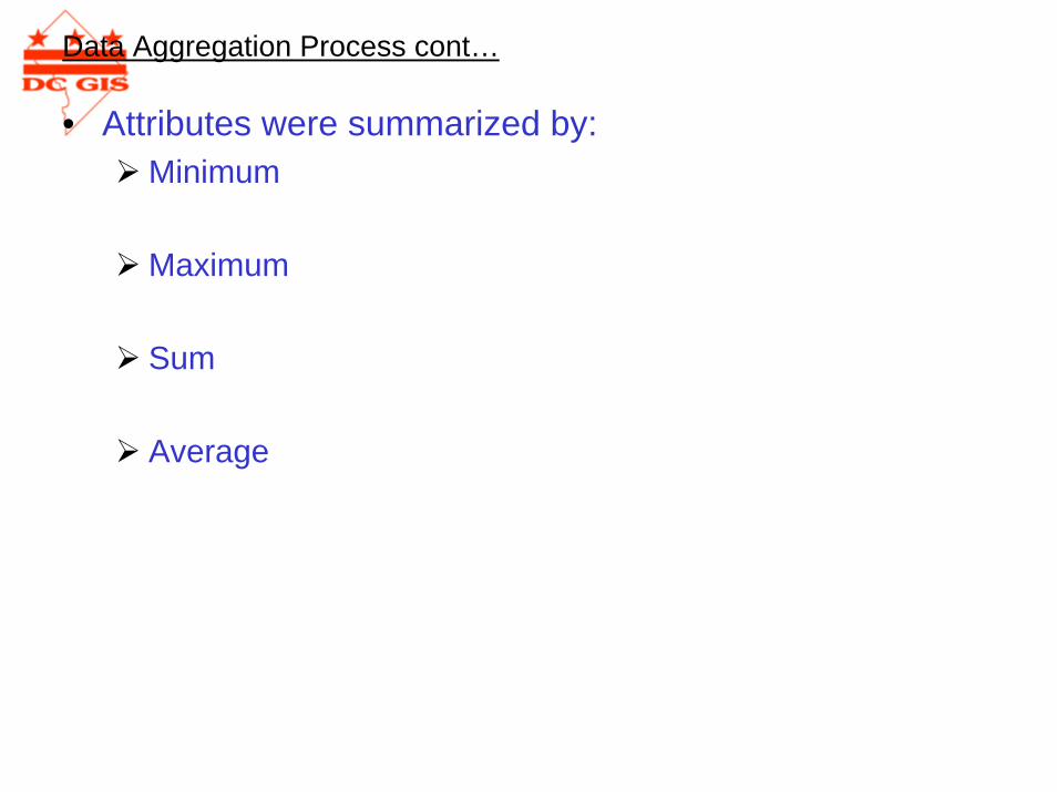
• Attributes were summarized by: Minimum
Maximum
Sum
Average
Data Aggregation Process cont…
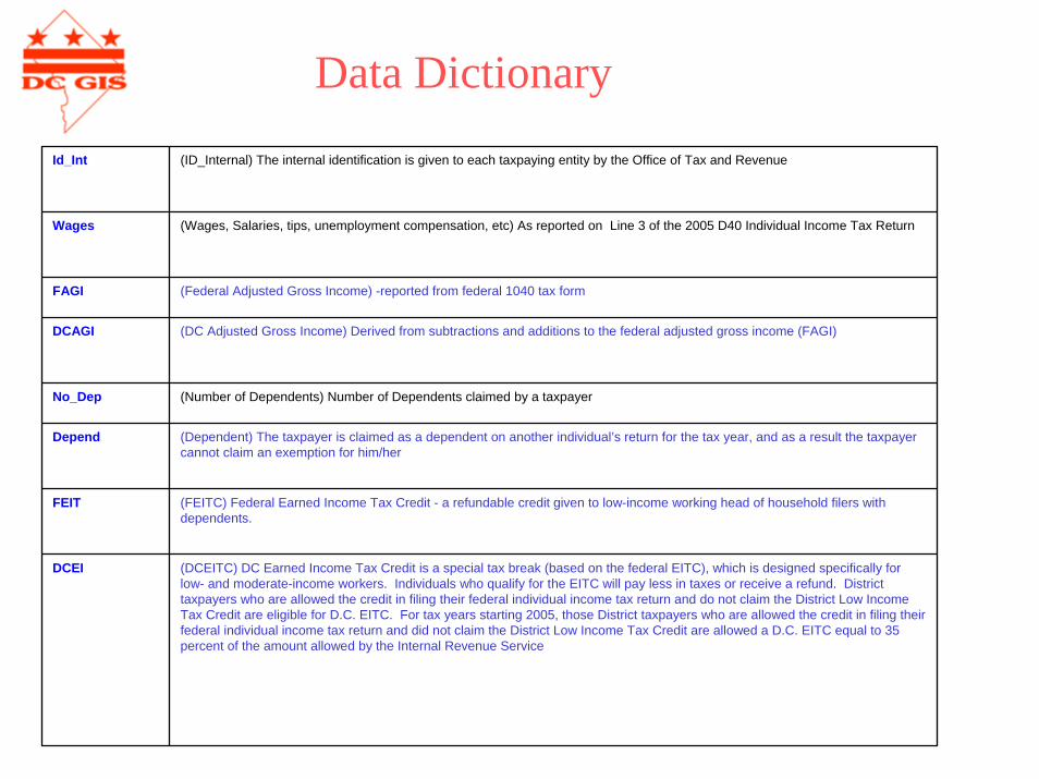
Data Dictionary
Id_Int (ID_Internal) The internal identification is given to each taxpaying entity by the Office of Tax and Revenue
Wages (Wages, Salaries, tips, unemployment compensation, etc) As reported on Line 3 of the 2005 D40 Individual Income Tax Return
FAGI (Federal Adjusted Gross Income) -reported from federal 1040 tax form
DCAGI (DC Adjusted Gross Income) Derived from subtractions and additions to the federal adjusted gross income (FAGI)
No_Dep (Number of Dependents) Number of Dependents claimed by a taxpayer
Depend (Dependent) The taxpayer is claimed as a dependent on another individual’s return for the tax year, and as a result the taxpayer cannot claim an exemption for him/her
FEIT (FEITC) Federal Earned Income Tax Credit - a refundable credit given to low-income working head of household filers with dependents.
DCEI (DCEITC) DC Earned Income Tax Credit is a special tax break (based on the federal EITC), which is designed specifically for low- and moderate-income workers. Individuals who qualify for the EITC will pay less in taxes or receive a refund. District taxpayers who are allowed the credit in filing their federal individual income tax return and do not claim the District Low Income Tax Credit are eligible for D.C. EITC. For tax years starting 2005, those District taxpayers who are allowed the credit in filing their federal individual income tax return and did not claim the District Low Income Tax Credit are allowed a D.C. EITC equal to 35 percent of the amount allowed by the Internal Revenue Service
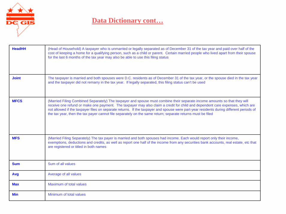
Data Dictionary cont…
HeadHH (Head of Household) A taxpayer who is unmarried or legally separated as of December 31 of the tax year and paid over half of thecost of keeping a home for a qualifying person, such as a child or parent. Certain married people who lived apart from their spouse for the last 6 months of the tax year may also be able to use this filing status
Joint The taxpayer is married and both spouses were D.C. residents as of December 31 of the tax year, or the spouse died in the tax year and the taxpayer did not remarry in the tax year. If legally separated, this filing status can’t be used
MFCS (Married Filing Combined Separately) The taxpayer and spouse must combine their separate income amounts so that they will receive one refund or make one payment. The taxpayer may also claim a credit for child and dependent care expenses, which are not allowed if the taxpayer files on separate returns. If the taxpayer and spouse were part-year residents during different periods of the tax year, then the tax payer cannot file separately on the same return; separate returns must be filed
MFS (Married Filing Separately) The tax payer is married and both spouses had income. Each would report only their income, exemptions, deductions and credits, as well as report one half of the income from any securities bank accounts, real estate, etc that are registered or titled in both names
Sum Sum of all values
Avg Average of all values
Max Maximum of total values
Min Minimum of total values
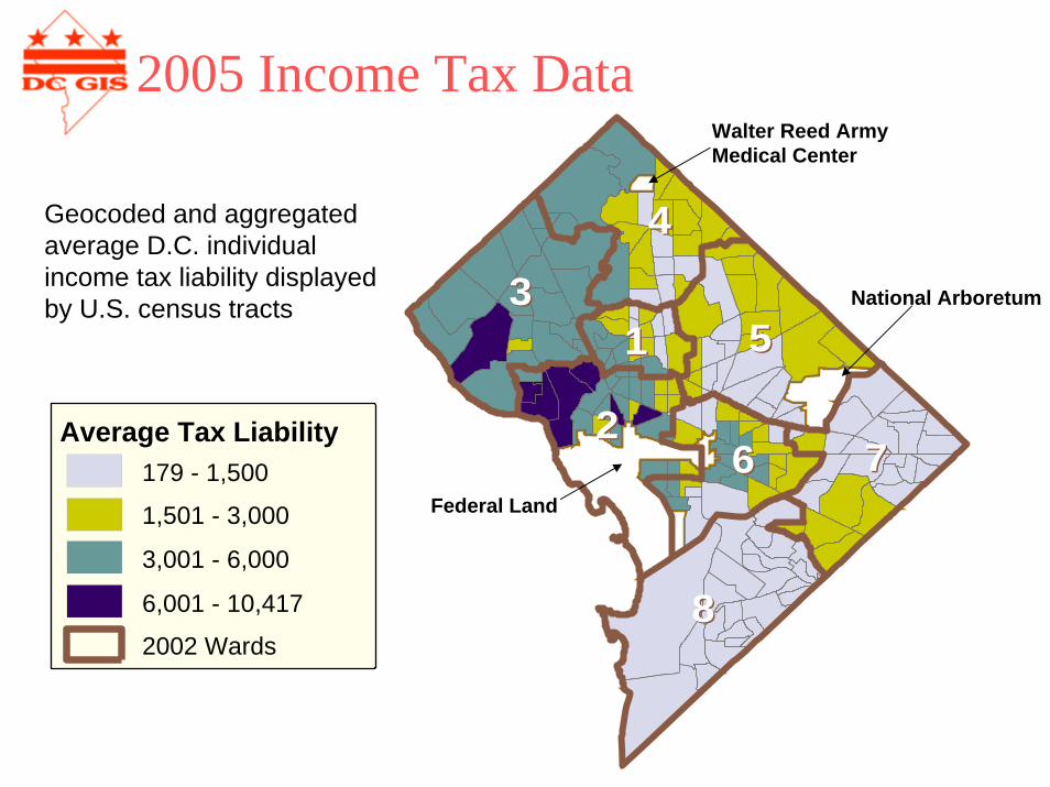
2005 Income Tax Data
Geocoded and aggregated average D.C. individual income tax liability displayed by U.S. census tracts
88
3355
22
44
7766
11
Federal Land
National Arboretum
Walter Reed Army Medical Center
Average Tax Liability179 - 1,500
1,501 - 3,000
3,001 - 6,000
6,001 - 10,417
2002 Wards
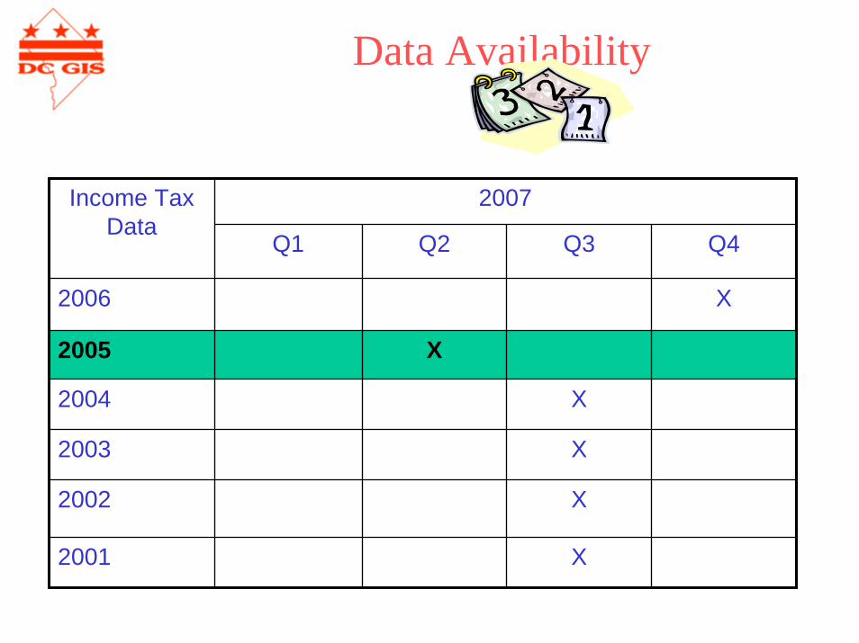
Data Availability
2007Income Tax Data
Q1 Q2 Q3 Q4
X
X
X
X
2006 X
2005 X
2004
2003
2002
2001
Other Applications
• ExamplesEITC can be used as proxy for low-income working families to target service delivery
Combine with crime, health, education and other statistics for planning purposes or general research

Presentation ofThe use of the US National Grid
to Uniquely Identify AssetThe use of the US National Grid
to Uniquely Identify Asset
Introduction
By
Louis Desjardins
DC WASA.
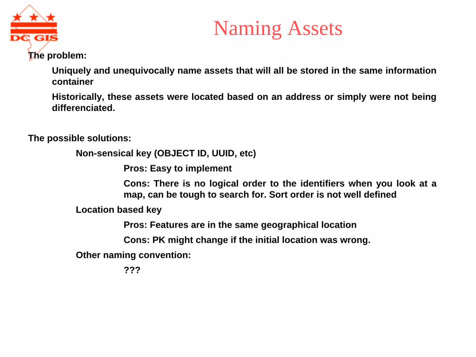
Naming AssetsThe problem:
Uniquely and unequivocally name assets that will all be stored in the same information containerHistorically, these assets were located based on an address or simply were not being differenciated.
The possible solutions:Non-sensical key (OBJECT ID, UUID, etc)
Pros: Easy to implementCons: There is no logical order to the identifiers when you look at a map, can be tough to search for. Sort order is not well defined
Location based keyPros: Features are in the same geographical locationCons: PK might change if the initial location was wrong.
Other naming convention:???

What is the US National Grid?The U.S. National Grid System is an alpha-numeric reference system that overlays the UTM coordinate system. It is a "Federal Geographic Data Committee" (FGDC) standard developed to improve public safety, commerce, as well as aid the casual GPS user. The USNG provides can easy to use geoaddress system for identifying and determining locations with the help of a USNG gridded map and/or a USNG enabled GPS system.
The objective of the U.S. National Grid standard is to create a more interoperable environment for developing location-based services within the United States and to increase the interoperability of location services appliances with printed map products by establishing a nationally consistent grid reference system as the preferred grid for NSDI applications. The U.S. National Grid is based on universally-defined coordinate and grid systems and can, therefore, be easily extended for use world-wide as a universal grid reference system.
The US National Grid
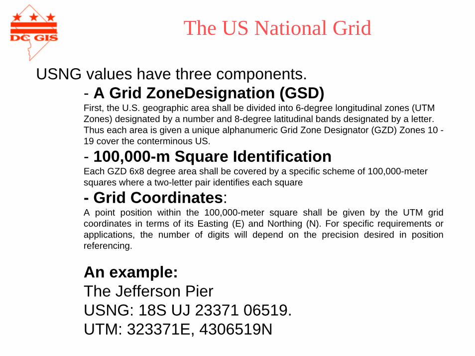
USNG values have three components. - A Grid ZoneDesignation (GSD)First, the U.S. geographic area shall be divided into 6-degree longitudinal zones (UTM Zones) designated by a number and 8-degree latitudinal bands designated by a letter. Thus each area is given a unique alphanumeric Grid Zone Designator (GZD) Zones 10 -19 cover the conterminous US.
- 100,000-m Square IdentificationEach GZD 6x8 degree area shall be covered by a specific scheme of 100,000-meter squares where a two-letter pair identifies each square
- Grid Coordinates:A point position within the 100,000-meter square shall be given by the UTM grid coordinates in terms of its Easting (E) and Northing (N). For specific requirements or applications, the number of digits will depend on the precision desired in position referencing.
An example:The Jefferson Pier USNG: 18S UJ 23371 06519.UTM: 323371E, 4306519N
The US National Grid
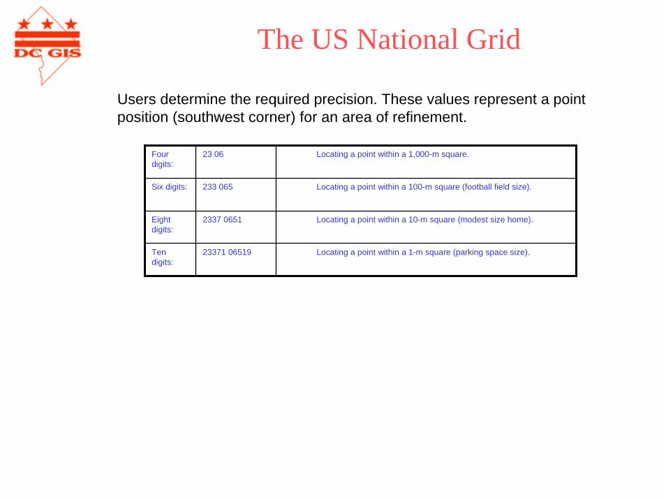
Users determine the required precision. These values represent a point position (southwest corner) for an area of refinement.
Four digits:
23 06 Locating a point within a 1,000-m square.
Six digits: 233 065 Locating a point within a 100-m square (football field size).
Eight digits:
2337 0651 Locating a point within a 10-m square (modest size home).
Ten digits:
23371 06519 Locating a point within a 1-m square (parking space size).
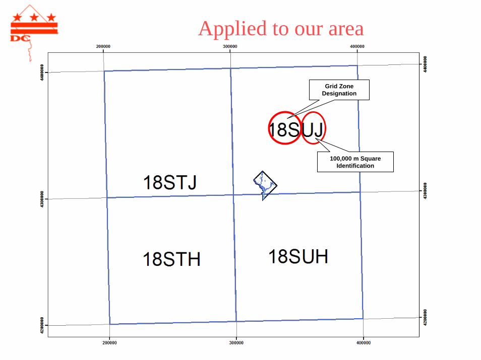
Applied to our area
100,000 m Square Identification
Grid Zone Designation
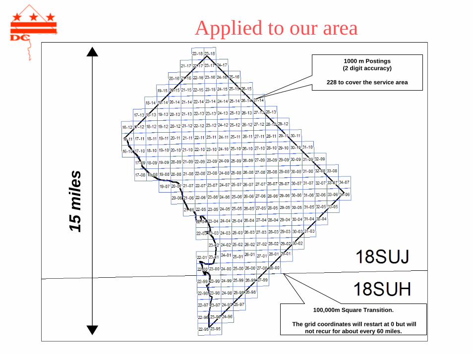
Applied to our area1000 m Postings(2 digit accuracy)
228 to cover the service area
100,000m Square Transition.
The grid coordinates will restart at 0 but will not recur for about every 60 miles.
15 m
iles
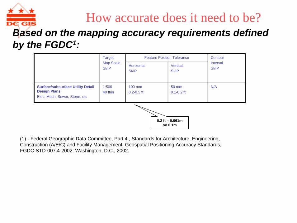
How accurate does it need to be?
(1) - FConstructiFGDC-ST
ederal Geographic Data Committee, Part 4., Standards for Architecture, Engineering,on (A/E/C) and Facility Management, Geospatial Positioning Accuracy Standards, D-007.4-2002: Washington, D.C., 2002.
Feature Position ToleranceTarget Map ScaleSI/IP
HorizontalSI/IP
VerticalSI/IP
Contour IntervalSI/IP
Surface/subsurface Utility Detail Design PlansElec, Mech, Sewer, Storm, etc
1:50040 ft/in
100 mm0.2-0.5 ft
50 mm0.1-0.2 ft
N/A
0.2 ft = 0.061mso 0.1m
Based on the mapping accuracy requirements defined by the FGDC1:
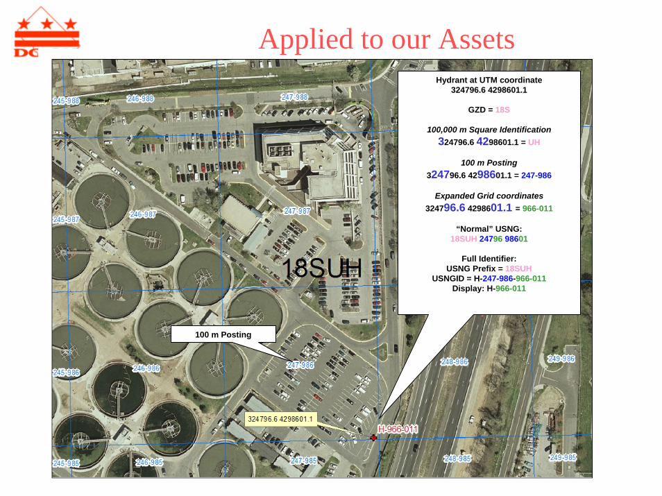
Applied to our Assets
100 m Posting
Hydrant at UTM coordinate324796.6 4298601.1
GZD = 18S
100,000 m Square Identification324796.6 4298601.1 = UH
100 m Posting324796.6 4298601.1 = 247-986
Expanded Grid coordinates324796.6 4298601.1 = 966-011
“Normal” USNG:18SUH 24796 98601
Full Identifier:USNG Prefix = 18SUH
USNGID = H-247-986-966-011Display: H-966-011

Thank you
Next DC GIS Steering Committee Meeting:
Thursday, September 6, 2007at 1:00 p.m.
Conference Room TBD441 4th Street NW