Embed Size (px)
Citation preview
Development of a Web–based Cadastral Survey Project Management Information System in Support to the Lands Management Bureau of the Philippine Government, (7246) Randolf Vicente (Philippines) FIG Congress 2014 Engaging the Challenges – Enhancing the Relevance Kuala Lumpur, Malaysia 16-‐21 June 2014
1/15 Develo
Development of a Web-based Cadastral Survey Project Management Information System in Support of the Lands Management Bureau of the
Philippine Government
Randolf SEVIDAL VICENTE, Philippines Key words: cadastral survey, up-to-date and reliable data, CSPMIS, project management, capability building SUMMARY The Philippine’s Department of Environment and Natural Resources (DENR) through the Lands Management Bureau (LMB) has been engaged in the full-scale implementation of the Cadastral Survey Program which mirrors the government’s seriousness to pursue programs that bring immediate and substantial benefits to the poor. The Cadastral Survey Program management has encountered inadequacies in terms of availability, supply and use of reliable data or information for the National Cadastral Project Coordinating Office (NCPCO). With the increase of cadastral surveys for FY 2012 to 2014, the LMB deemed it wise to infuse the use of an appropriate project management tool for use by the NCPCO and the Regional Cadastral Project Coordinators (RCPC) of LMB and the Lands Management Services (LMS), respectively. Due to its limited expertise, the LMB commissioned the services of a private consulting firm trough an unsolicited proposal to develop a Web-based Cadastral Survey Project Management Information System or CSPMIS for private consulting services outsourcing, stakeholders project profiling, assessment of DENR project inputs, contract administration, automated project feedback mechanism e.g., document and action tracking, near-real time monitoring and evaluation of physical and financial status, internal responsibility assignment and performance assessment, among others. The Consultant finally installed is the 10-module CSPMIS. Also submitted to LMB are the fully documented guidelines governing the operationalization of the CSPMIS, Technical Documentation, and Users’ Manuals. Over 60 End-Users were trained. The CSPMIS has significantly contributed to LMB’s improvement in the internal project life cycle management capacity, better feedback mechanism, enrichment in procurement transparency and accountability measures, and jumpstarted productivity development towards an improved public investment management.
Development of a Web–based Cadastral Survey Project Management Information System in Support to the Lands Management Bureau of the Philippine Government, (7246) Randolf Vicente (Philippines) FIG Congress 2014 Engaging the Challenges – Enhancing the Relevance Kuala Lumpur, Malaysia 16-‐21 June 2014
2/15 Develo
Development of a Web-based Cadastral Survey Project Management Information System in Support of the Lands Management Bureau of the
Philippine Government
Randolf SEVIDAL VICENTE, Philippines 1. INTRODUCTION The Department of Environment and Natural Resources (DENR) has been engaged with the full-scale implementation of Cadastral Survey Projects since FY-2007. In FY-2012 alone, the agency has programmed over 295 municipalities/cities with a total estimated budget of PhP 3.56 Billion or approximately USD 8.28 Million. The project gives muscle to the marching order of His Excellency President Benigno S. Aquino III to hasten and complete the cadastral survey of the country which mirrors the government’s seriousness to pursue programs that bring immediate and substantial benefits to the poor. The DENR, through the Lands Management Bureau or LMB (formerly the Bureau of Lands) and Lands Management Services (LMS) under the DENR Regional Offices, are the ones spearheading cadastral surveys pursuant to Executive Order No. 192. The LMB serves as the staff bureau of the DENR tasked to carry out the functions on planning, policy development, and monitoring and evaluation of cadastral surveys, among others. The LMS offices act as the implementing units covering the aspects of procurement, contract administration, management of the implementation of field surveys, inspection until the approval of surveys, and the preparation of reports for submission to the LMB and the DENR Central Office. Act 2259, otherwise known as the “Cadastral Act of 1913”, and Commonwealth Act No. 141, also known as the “Public Land Act of 1936”, serve as the legal bases of cadastral surveys. Encountered in the past are the technical, institutional, operational, political, legal, and fiscal issues which impeded the successful completion of most survey projects. These comprise the challenges that will test the capacity to LMB and the LMS offices in the management of ongoing and pipe-lined cadastral projects. With the increased targets in cadastral surveys for FY 2012, there is an urgent need to infuse a component which institutionalizes the use of appropriate information systems to serve as a project management tool for the LMB and LMS offices. As such, an unsolicited consulting service proposal was approved by the LMB for the “Development of a Web-based Cadastral Survey Project Management Information System or CSPMIS” covering the features on private consulting services outsourcing, stakeholders project profiling, assessment of DENR project inputs, contract administration, automated project feedback mechanism e.g., document
Development of a Web–based Cadastral Survey Project Management Information System in Support to the Lands Management Bureau of the Philippine Government, (7246) Randolf Vicente (Philippines) FIG Congress 2014 Engaging the Challenges – Enhancing the Relevance Kuala Lumpur, Malaysia 16-‐21 June 2014
3/15 Develo
and action tracking, near-real time monitoring and evaluation of physical and financial status, internal responsibility assignment and performance assessment, among others. 2. CADASTRAL SURVEY OPERATIONS: A SITUATIONER This Section provides the overview of cadastral surveys, cadastral survey project management, and project management information needs.
2.1 Overview of Cadastral Surveys The Cadastral Survey Program is aimed at providing a comprehensive and accurate data on land resources, map-based data for zoning and land use planning, and economic data for land-based development studies and projects. It also intends to delineate the boundaries of all political subdivisions, facilitate land disposition, and accelerate the settlement of claims and adjudication of land cases and conflicts. According to the LMB, cadastral survey is defined as “the survey of extensive areas covering a municipality or city or a portion thereof for general land registration proceedings, agricultural development and other purposes”. It involves the survey of the whole municipality or an extensive portion of it by identifying the individual ownership or claims over land and delineating the boundaries thereto. The delineation of boundaries of various political units such as “barangay” (smallest political subdivision/jurisdiction), city/municipality and province are likewise included. A cadastral survey project incorporates interrelated office- and field-based activities in order to achieve the said objectives. Pursuant to the provisions of DENR Administrative Order No. 2007-29, the major components of a cadastral survey project are as follows:
a. Project Control Survey – Includes the establishment of main and subsidiary
project controls over the entire area covered by the cadastral project.
b. Political Boundary Survey – Encompasses the establishment of political boundary monuments defining the boundary lines of the entire municipality/city and their component “barangays”. Disputed areas are shown on the cadastral maps.
c. Parcellary/Lot Survey – Incorporates the determination of individual lot boundaries and their corresponding attributes primarily for the purpose of acquiring title thereto. Other lands which cannot be subjected to private ownership such as forestland/timberland, government reservations, protected areas/sanctuaries, government centers, and the like also covered by lot surveys and assigned with corresponding cadastral lot numbers. Lots covered by
Development of a Web–based Cadastral Survey Project Management Information System in Support to the Lands Management Bureau of the Philippine Government, (7246) Randolf Vicente (Philippines) FIG Congress 2014 Engaging the Challenges – Enhancing the Relevance Kuala Lumpur, Malaysia 16-‐21 June 2014
4/15 Develo
previously approved surveys are reflected on the cadastral maps as either accepted or amended.
The project also involves the active participation of lot claimants/owners as well as the subject and adjacent local government units (LGUs). 2.2 Cadastral Survey Project Management The NCPCO was created at the LMB pursuant to DENR Memorandum Order No. 2011-03 entitled, “Establishment for a Project Monitoring System for the Cadastral Survey Program of the DENR”. The NCPCO is headed by the National Cadastral Project Coordinator (NCPC) under the direct supervision of the LMB Director. The NCPC is responsible for, but not limited to perform, the following:
a. Monitors the implementation of the Cadastral Survey Projects nationwide;
b. Coordinates with the Regional Cadastral Project Coordinator (RCPC) in monitoring and evaluation of Cadastral Surveys Projects in their respective regions and the timely submission of the physical and financial reports to the DENR and LMB;
c. Prepares the NCPCO Work and Financial Plan (WFP) and assists the Regional Offices in the preparation of their WFP for Cadastral Surveys and facilitate in the timely releases of funds to the Regional Offices; and
d. Establishes and maintains a database on Physical and Financial Status of National Cadastral Survey implementation.
In addition to the above, the NCPC consolidates all the reports from the LMS regional offices and submits corresponding reports to the DENR Central Office particularly the Planning and Policy Studies Office (PPSO) and Financial Management Services (FMS). 2.3 Project Management Information Needs The Cadastral Survey Program is classic example of an essential development initiative of the present administration which must have well-defined and desirable characteristics to support project management functions. It is indeed a huge investment which brings about social and economic benefits to the public. With the significant amount of public investment poured into by the national leadership to complete the cadastral surveys, there is a need to develop and operationalize appropriate project management tools that will satisfy and sustain the necessary operational requirements at all levels and phases of work from pre-survey to survey proper
Development of a Web–based Cadastral Survey Project Management Information System in Support to the Lands Management Bureau of the Philippine Government, (7246) Randolf Vicente (Philippines) FIG Congress 2014 Engaging the Challenges – Enhancing the Relevance Kuala Lumpur, Malaysia 16-‐21 June 2014
5/15 Develo
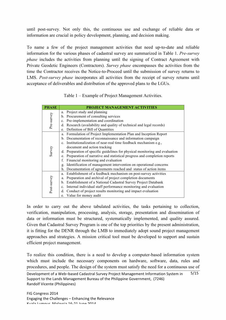
until post-survey. Not only this, the continuous use and exchange of reliable data or information are crucial in policy development, planning, and decision making. To name a few of the project management activities that need up-to-date and reliable information for the various phases of cadastral survey are summarized in Table 1. Pre-survey phase includes the activities from planning until the signing of Contract Agreement with Private Geodetic Engineers (Contractors). Survey phase encompasses the activities from the time the Contractor receives the Notice-to-Proceed until the submission of survey returns to LMS. Post-survey phase incorporates all activities from the receipt of survey returns until acceptance of deliverables and distribution of the approved plans to the LGUs.
Table 1 – Example of Project Management Activities.
PHASE PROJECT MANAGEMENT ACTIVITIES
Pre-
surv
ey a. Project study and planning
b. Procurement of consulting services c. Pre-implementation and coordination d. Research (availability and quality of technical and legal records) e. Definition of Bill of Quantities
Surv
ey
a. Formulation of Project Implementation Plan and Inception Report b. Documentation of reconnaissance and information campaign c. Institutionalization of near-real time feedback mechanism e.g.,
document and action tracking d. Preparation of specific guidelines for physical monitoring and evaluation e. Preparation of narrative and statistical progress and completion reports f. Financial monitoring and evaluation g. Identification of management intervention on operational concerns h. Documentation of agreements reached and status of action items
Post
-sur
vey
a. Establishment of a feedback mechanism on post-survey activities a. Preparation and archival of project completion documents b. Establishment of a National Cadastral Survey Project Databank c. Internal individual staff performance monitoring and evaluation d. Conduct of project results monitoring and impact evaluation e. Value for money audit
In order to carry out the above tabulated activities, the tasks pertaining to collection, verification, manipulation, processing, analysis, storage, presentation and dissemination of data or information must be structured, systematically implemented, and quality assured. Given that Cadastral Survey Program is one of the top priorities by the present administration, it is fitting for the DENR through the LMB to immediately adopt sound project management approaches and strategies. A mission critical tool must be developed to support and sustain efficient project management. To realize this condition, there is a need to develop a computer-based information system which must include the necessary components on hardware, software, data, rules and procedures, and people. The design of the system must satisfy the need for a continuous use of
Development of a Web–based Cadastral Survey Project Management Information System in Support to the Lands Management Bureau of the Philippine Government, (7246) Randolf Vicente (Philippines) FIG Congress 2014 Engaging the Challenges – Enhancing the Relevance Kuala Lumpur, Malaysia 16-‐21 June 2014
6/15 Develo
up-to-date and reliable data or information under a dynamic Information and Communications Technology (ICT) environment for project management purposes. Crucial to this scenario is the conduct of capability building activities for the End-users of the system. Under such premises and to ensure a well-functioning NCPCO and RCPCOs, the design and development of CSPMIS was approved and undertaken immediately to support the LMB and LMS in organizing, overseeing, monitoring and evaluating cadastral survey projects, and to guide the top level managers and decision makers concerned in taking appropriate management interventions when needed. 3. PROJECT OVERVIEW Discussed below are the objectives, key operating principles, scope and limitations, and the duration and deliverables.
3.1 Objectives and Key Operating Principles The engagement aims to develop an ICT-based project management tool that can be utilized by the intended End-Users of LMB and LMS covering at least 14 modules geared towards ensuring near-real time monitoring and evaluation, better feedback mechanism, enhanced transparency, improved accountability, and increased internal capacity. The consulting service engagement has the following specific purposes:
a. To design and develop Web-based CSPMIS in support to cadastral survey project
management;
b. To establish in-house capability in the utilization of CSPMIS at the LMB and the LMS offices;
c. To develop implementing guidelines for the utilization and maintenance of the CSPMIS consistent with the existing ICT policy of the DENR; and
d. To prepare and submit reports, system technical documents, Users’ Manual, and training materials.
To achieve these objectives, the development of CSPMIS was undertaken under the key operating principles as follows: (a) participative/consultative; (b) integrative; (c) need-based skills development; (d) comprehensive; (e) consistency with industry standards; (f) guided system operationalization; and (g) complete documentation for proper traceability.
3.2 Scope of Work
Development of a Web–based Cadastral Survey Project Management Information System in Support to the Lands Management Bureau of the Philippine Government, (7246) Randolf Vicente (Philippines) FIG Congress 2014 Engaging the Challenges – Enhancing the Relevance Kuala Lumpur, Malaysia 16-‐21 June 2014
7/15 Develo
In order to carry out the development of the system and be able to produce the expected deliverables, the scope of work includes the following: (a) system analysis; (b) database design; (c) system design and development; (d) evaluation and modification; and (e) integration and operationalization.
The CSPMIS covers 14 information system modules that are relevant to the management of cadastral survey projects. These are as follows: (a) Project Summary; (b) Geodetic Engineer – Contractor Profile; (c) Project Chief Profile; (d) Project Geodetic Engineer Profile; (e) Partnership/Corporate Profile; (f) Government Geodetic Engineer’s Profile; (g) Procurement and Resources Information; (h) Contract Agreement Information; (i) Internal Project Inputs Assessment; (j) Document and Action Tracking; (k) Contract Administration; (l) Physical Report; (m) Financial Report; and (n) Overall Project Status. The system does not include the spatial component and automatic survey conflict matching.
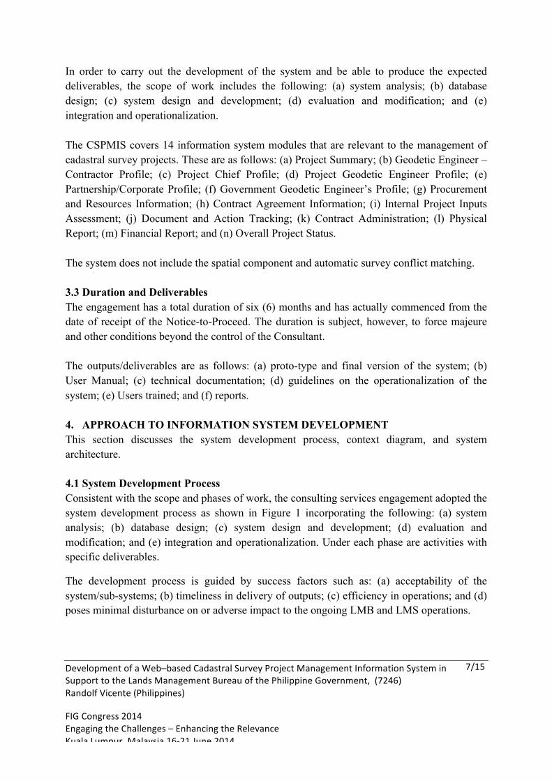
3.3 Duration and Deliverables The engagement has a total duration of six (6) months and has actually commenced from the date of receipt of the Notice-to-Proceed. The duration is subject, however, to force majeure and other conditions beyond the control of the Consultant. The outputs/deliverables are as follows: (a) proto-type and final version of the system; (b) User Manual; (c) technical documentation; (d) guidelines on the operationalization of the system; (e) Users trained; and (f) reports. 4. APPROACH TO INFORMATION SYSTEM DEVELOPMENT This section discusses the system development process, context diagram, and system architecture. 4.1 System Development Process Consistent with the scope and phases of work, the consulting services engagement adopted the system development process as shown in Figure 1 incorporating the following: (a) system analysis; (b) database design; (c) system design and development; (d) evaluation and modification; and (e) integration and operationalization. Under each phase are activities with specific deliverables.
The development process is guided by success factors such as: (a) acceptability of the system/sub-systems; (b) timeliness in delivery of outputs; (c) efficiency in operations; and (d) poses minimal disturbance on or adverse impact to the ongoing LMB and LMS operations.
Development of a Web–based Cadastral Survey Project Management Information System in Support to the Lands Management Bureau of the Philippine Government, (7246) Randolf Vicente (Philippines) FIG Congress 2014 Engaging the Challenges – Enhancing the Relevance Kuala Lumpur, Malaysia 16-‐21 June 2014
8/15 Develo
4.2 Context Diagram Figure 2 shows the Context Diagram of CSPMIS. It basically shows the relationship between the Administrator and the Users. The Administrator has the full authority over the system including the management of User permissions and the whole CSPMIS storage. The primary role of the Users is to encode and add data into the CSPMIS. They can only modify (edit or delete) uploaded data if the Administrator will allow it.
4.3 System Architecture The System Architecture serves as the engine design of the CSPMIS. It shows the requirements needed for it to work properly, and generally supports the creation of the Web- based CSPMIS to meet the Users’ requirements.
Figure 2 - Context Diagram.
Figure 1 - System Development Process.
Development of a Web–based Cadastral Survey Project Management Information System in Support to the Lands Management Bureau of the Philippine Government, (7246) Randolf Vicente (Philippines) FIG Congress 2014 Engaging the Challenges – Enhancing the Relevance Kuala Lumpur, Malaysia 16-‐21 June 2014
9/15 Develo
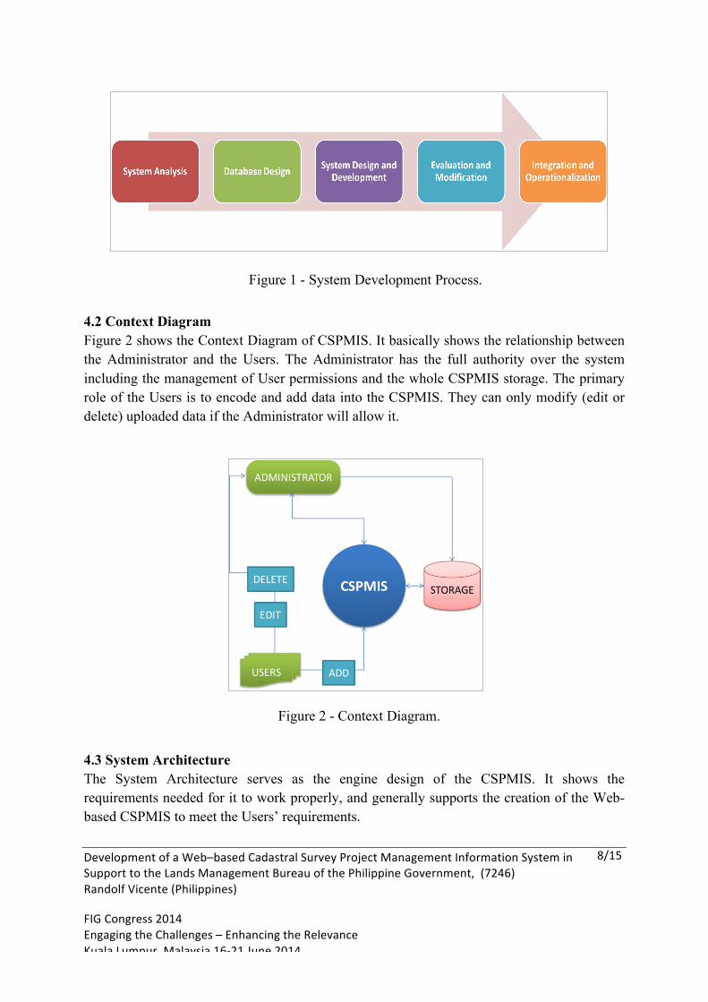
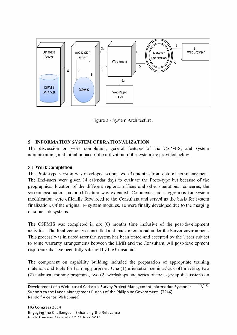
The CSPMIS Architecture is illustrated in Figure 3. It shows how the system fits within a standard Web application structure. The process flow in the System Architecture is described as follows:
a. The Web Browser sends a request for a static or dynamic resource to the Web Server.
b. The Web Server decides what to do with the request.
i. Static resources such as static Web pages and Hypertext Macro Language (HTML) are read from the disk and returned directly to browser.
ii. Requests for dynamic resources such as a CSPMIS login page are
forwarded to an Application Server.
c. The Application Server passes the request to the correct Web application.
d. The Web application constructs a response using data from the Database Server when necessary.
e. The response is passed back to the sequence to the Browser.
f. The Web Browser displays the response.
Development of a Web–based Cadastral Survey Project Management Information System in Support to the Lands Management Bureau of the Philippine Government, (7246) Randolf Vicente (Philippines) FIG Congress 2014 Engaging the Challenges – Enhancing the Relevance Kuala Lumpur, Malaysia 16-‐21 June 2014
10/15
5. INFORMATION SYSTEM OPERATIONALIZATION The discussion on work completion, general features of the CSPMIS, and system administration, and initial impact of the utilization of the system are provided below. 5.1 Work Completion The Proto-type version was developed within two (3) months from date of commencement. The End-users were given 14 calendar days to evaluate the Proto-type but because of the geographical location of the different regional offices and other operational concerns, the system evaluation and modification was extended. Comments and suggestions for system modification were officially forwarded to the Consultant and served as the basis for system finalization. Of the original 14 system modules, 10 were finally developed due to the merging of some sub-systems. The CSPMIS was completed in six (6) months time inclusive of the post-development activities. The final version was installed and made operational under the Server environment. This process was initiated after the system has been tested and accepted by the Users subject to some warranty arrangements between the LMB and the Consultant. All post-development requirements have been fully satisfied by the Consultant. The component on capability building included the preparation of appropriate training materials and tools for learning purposes. One (1) orientation seminar/kick-off meeting, two (2) technical training programs, two (2) workshops and series of focus group discussions on
Figure 3 - System Architecture.
Development of a Web–based Cadastral Survey Project Management Information System in Support to the Lands Management Bureau of the Philippine Government, (7246) Randolf Vicente (Philippines) FIG Congress 2014 Engaging the Challenges – Enhancing the Relevance Kuala Lumpur, Malaysia 16-‐21 June 2014
11/15
policy development were organized and successfully accomplished. The training program methodology involved lecture sessions, workshop, and hands-on learning. Documentation activities encompassed the preparation of technical documents, Users Manuals, training materials, and reports. The necessary after-sales support is three (3) months from the date of turn-over of deliverables were already complied with. 5.2 General Features of the CSPMIS The front end of the CSPMIS is based on Hypertext Preprocessor (PHP) which is a server side script programming language while the database is handled by My Structured Query Language (MySQL) which is an open source Relational Database Management System (RDBMS) that runs as a Server capable of providing multi-User access to the database. The final version of the CSPMIS has the following basic features:
a. User friendly;
b. Operates real-time that enable Users to receive data and information once these are uploaded or published;
c. Provides outputs by generating Web pages;
d. Able to convert data into different file formats;
e. Contains an advance search functionality;
f. Some data fields have an input validation that helps the User to be resilient;
g. Accessible to Users over a Network such as Internet or an Intranet through a Web Browser;
h. User interface accepts inputs via devices such as iPods and smart phones;
i. Needs on a “single installation” through the LMB Web Server;
j. Compatible with all operating system platforms;
k. Can be used multiple and concurrent Users nationwide;
Development of a Web–based Cadastral Survey Project Management Information System in Support to the Lands Management Bureau of the Philippine Government, (7246) Randolf Vicente (Philippines) FIG Congress 2014 Engaging the Challenges – Enhancing the Relevance Kuala Lumpur, Malaysia 16-‐21 June 2014
12/15
l. Contains security features such as login page, setting of User’s permission and others for the protection of data and information; and
m. System operation is governed by implementing guidelines. 5.3 System Administration At present, the NCPC acts as the System Administrator. The Management Information System (MIS) Unit of the LMB provides the necessary technical assistance to the System Administrator. The Administrator Page is provided solely for use by the System Administrator. The Administrator can set User’s permissions and privileges in using the system. Check boxes are equivalent to “yes” and “no” to set permissions. A “Listbox” is used to cluster User groups. In terms of permission, this feature allows the process of assigning authority to a group by choosing groups from the list box, and then simply checking the allowed permissions of a certain group to each table in the system. The Administrator’s area is not accessible by all Users. It is hidden in the normal level User’s menu. In this menu permission, assigning of Users to groups and adding or deleting Users are decided. The system is intended only for the exclusive use of LMB but guests may be given limited access such as viewing and printing. Selected datasets will not be linked at this point to any other government office or agency but this scheme can be arranged under such conditions as stipulated in the proposed operating guidelines. 5.4 Initial Impact The summary of initial impact of utilization of CSPMIS based on the feedback from the NCPCO and the different Users based in the regions are summarized hereunder.
a. Availability of data and information for project study, planning, controlling,
monitoring and evaluation, and impact assessment;
b. Enhanced transparency in some regions on internal control and field operations from procurement until project turn-over;
c. Improved accountability mechanism for all officials and employees directly involved in cadastral survey project management;
Development of a Web–based Cadastral Survey Project Management Information System in Support to the Lands Management Bureau of the Philippine Government, (7246) Randolf Vicente (Philippines) FIG Congress 2014 Engaging the Challenges – Enhancing the Relevance Kuala Lumpur, Malaysia 16-‐21 June 2014
13/15
d. Better project monitoring system and feedback mechanism as information on operational issues and concerns needing immediate intervention became available and easily accessible;
e. More detailed overall project profile and status together with the required documentary attachments are now available and accessible;
f. Assurance of minimizing unnecessary delays, thus, better time and fiscal management;
g. Enhanced internal and external coordination and implementation arrangements;
h. Increase in terms of personnel that are capable of utilizing the system and supporting the management of cadastral survey projects; and
i. Increased internal capacity in project management and improved productivity.
6. CONCLUSION There are no amount of brilliant managers that can assure the government in effectively and efficiently managing cadastral survey projects without using real, up-to-date, and reliable data and information. The use of ICT solutions such as the Web-based CSPMIS redounds to the project’s initial impacts and benefits which evidently outweighs the investment cost. The religious utilization, maintenance and enhancement of the system will eradicate the inefficient use of physical resources, ensure that funds are prudently spent, and satisfy the pre-determined time frame and quality specifications of cadastral survey projects. Among the major challenges are the sincerity, commitment, and dedication of the employees and officials who are directly involved in the CSPMIS operationalization and those who were entrusted with such a huge public investment on land distribution and poverty alleviation.
Development of a Web–based Cadastral Survey Project Management Information System in Support to the Lands Management Bureau of the Philippine Government, (7246) Randolf Vicente (Philippines) FIG Congress 2014 Engaging the Challenges – Enhancing the Relevance Kuala Lumpur, Malaysia 16-‐21 June 2014
14/15
REFERENCES DENR, 2011, DENR Memorandum Circular No. 2011-03., Establishment for a Project Monitoring System for the Cadastral Survey Program of the DENR. DENR, 2011, Lands Management Bureau Medium-Term Development Plan 2011-2016. Pablo, R., 2012, Powerpoint Presentation on Cadastral Surveys. Vicente, R., 2008, Reengineering the Philippine Cadastral System (Unpublished). BIOGRAPHICAL NOTES Randolf Sevidal Vicente, MSc. Present Work: Proprietor, RSV Geoconsulting and Management Services Previous Work: Former OIC, Office of the Assistant Director, Mapping and Geodesy Department, National Mapping and Resource Information Authority, DENR (Philippines)

Development of a Web–based Cadastral Survey Project Management Information System in Support to the Lands Management Bureau of the Philippine Government, (7246) Randolf Vicente (Philippines) FIG Congress 2014 Engaging the Challenges – Enhancing the Relevance Kuala Lumpur, Malaysia 16-‐21 June 2014
15/15
Professional Societies/Organizations: Vice President, ASEAN Federation of Surveying and Geomatics Executive Vice President, Philippine Geodetic Eng’g and Geomatics Society, Inc. Executive Secretary, Confederation of Filipino Consulting Organizations Former Governor and Regional President, Geodetic Engineers of the Philippines, Inc.
Areas of Interest: Surveying and Geodesy, Multi-Level and Multi-Dimensional Mapping/Cartography, Geo-ICT Development and Application, Land Administration, Ecological Profiling, Development/Land Use Planning, Disaster Risk Reduction and Management, and Organizational/Institutional and Human Resource Development CONTACTS Randolf Sevidal Vicente, MSc. RSV Geoconsulting and Management Services No. 405 Prima Building, 16 East Avenue, Pinyahan Quezon City 1100 PHILIPPINES (+632) 920-1368 (+632) 916-217-8453 Email: [email protected]