Embed Size (px)
Citation preview
KØBENHAVNS MUSEUM / MUSEUM OF COPENHAGEN
Enghave Plads
KBM 3838, Udenbys Vester Kvarter, Vesterbro Sogn, Sokkelund
Herred, Københavns Amt
Kulturstyrelsen j.nr.: 2010-7.24.02/KBM-0015
Claus Rohden Olesen

2
Museum of Copenhagen
Vesterbrogade 59
1620 København V
Telefon: +45 33 21 07 72 Fax: +45 33 25 07 72
E-mail: [email protected]
www.copenhagen.dk
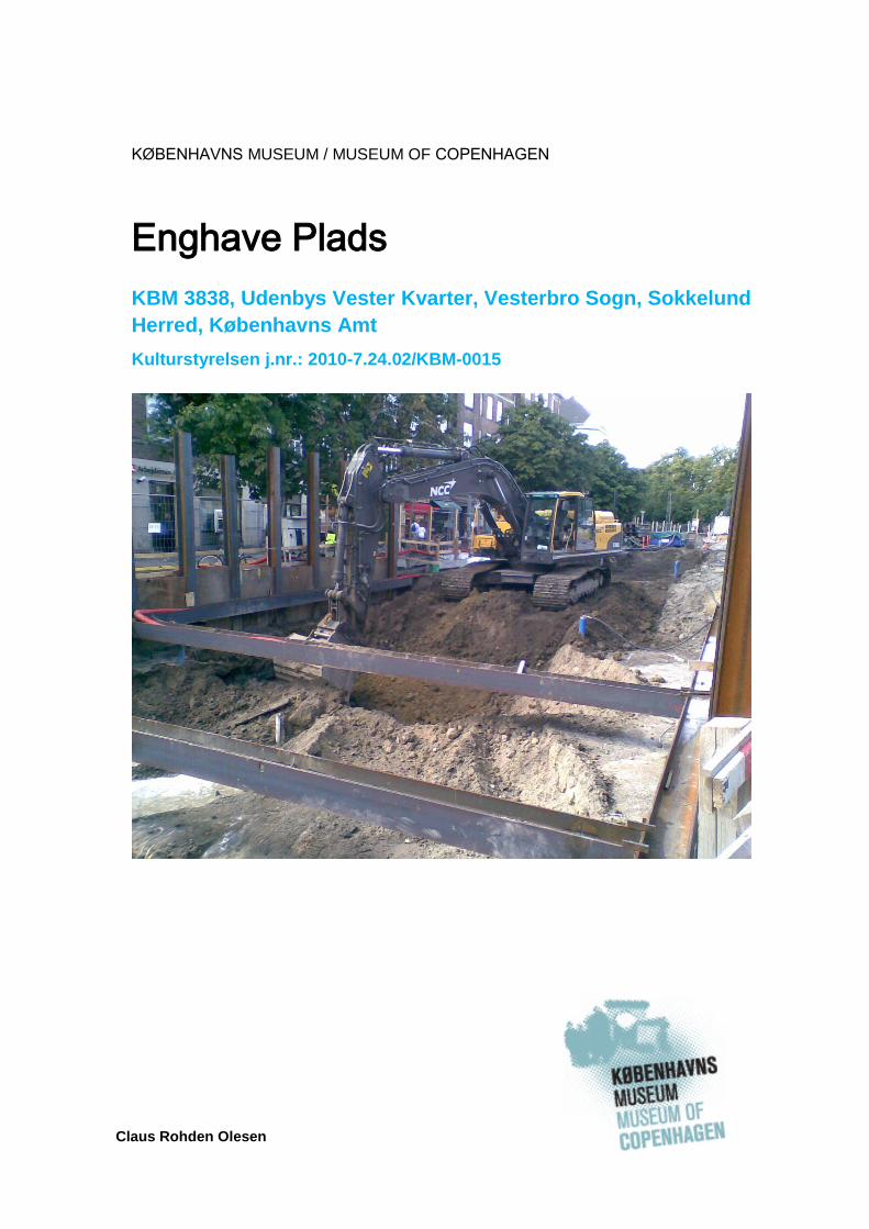
Cover illustration: Excavation at Enghave Plads
© Museum of Copenhagen 2015
3
Contents
1 Abstract/Resumé ................................................................................. 4
2 Introduction .......................................................................................... 7
2.1 Proposed Development ............................................................... 7
2.2 Legislative Framework ................................................................. 7
2.3 Administrative data ...................................................................... 7
2.4 Other data .................................................................................... 8
3 Topography and historical background ................................................ 9
3.1 Topography ................................................................................. 9
3.2 Cultural historical background ..................................................... 9
4 Archaeological background ................................................................ 13
5 Archaeological potential and aims ..................................................... 14
6 Methodology and measurement system ............................................ 15
6.1 Excavation and documentation .................................................. 15
6.2 Finds registration ....................................................................... 15
7 Results ............................................................................................... 17
7.1 Preservation .............................................................................. 17
7.2 Archaeological results................................................................ 17
7.3 Summary ................................................................................... 17
References .............................................................................................. 19
Literature ................................................................................... 19
Museum of Copenhagen strategy documents ........................... 19
Internet references .................................................................... 20
Abbreviations ............................................................................. 20
Appendices i
Finds Report ii
List of Finds v
4
1 Abstract/Resumé
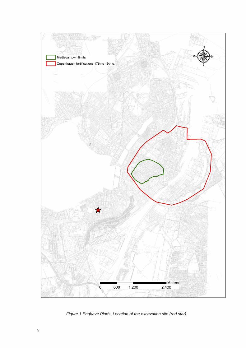
Prior to the construction of the metro Station on Enghave Plads, facilitated by Metroselskabet I/S (Metro Company), Museum of Copenhagen found it relevant to perform an evaluating pre-excavation in order to assess the culture-historical potential and the need of a more extensive archaeological excavation of Enghave Plads (Fig. 1, 2).
The archaeological work was performed as a major watching brief covering 2 583 m2, to a depth of 1,5 m. The location was situated in the central parts of Enghave Plads.
The area was characterized by vast amounts of dumped material mainly comprising household waste, demolition material and similar accumulations related to landfill. This seems to correspond with the general understanding of the area, i.e. it is build by landfill accumulated here in the 18th and 19th century prior and during the early stage of the industrialization of Copenhagen.
Resumé
Periods: Late Post medieval, Modern Time.
Features: Industrialization, modern City planning, historical pollution.
Keywords: Landfill, waste, demolition material, pottery.
Forud for Metroselskabet I/S’ byggeri af en Metrostation på Enghave Plads fandt Københavns Museum det relevant at foretage en arkæologisk forundersøgelse af området med henblik på at vurdere det kulturhistoriske potentiale i en videre arkæologisk undersøgelse af området.
Det arkæologiske feltarbejde blev udført som tilsyn. Samlet set blev et område på 2 583 m2, beliggende centralt på Enghave Plads, undersøgt til en dybde på 1,5 m.
Området var karakteriseret af enorme mængder af akkumuleringer af husholdningsaffald, byggeaffald samt lignende aflejringer af lossepladsmæssig karakter. Dette synes at korrespondere med den generelle opfattelse af områdets udviklingshistorie, dvs. kvarteret er etableret ovenpå store mængder af affald kørt ud fra København i 1700-1800-tallet frem til industrialiseringen for alvor ændrede områdets karakters til, hvad det er i dag.
Perioder: Nyere tid-moderne tid.
Temaer: Industrialisering, moderne byplanlægning, tidlig forurening.
Nøgleord: Losseplads, affald, byggeaffald, køkken- og bordtøj.
5
Figure 1.Enghave Plads. Location of the excavation site (red star).
6
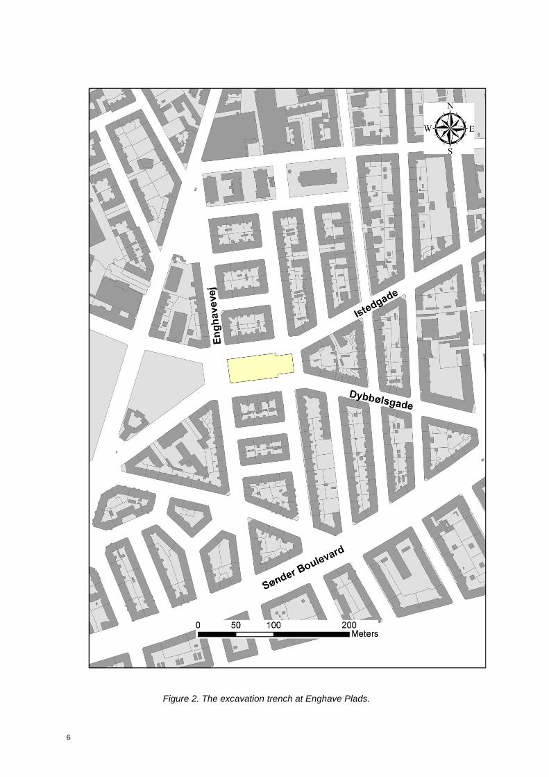
Figure 2. The excavation trench at Enghave Plads.
7
2 Introduction
2.1 Proposed Development
This investigation preceded the new metro station, which will be located at Enghave Plads (Figures 1 and 2). The station is located in the district of Vesterbro and is part of the City Ring Project, which will provide a new transportation system to the surrounding outskirts of the city. Archaeologists from Museum of Copenhagen were commissioned by Metroselskabet I/S (Metro Company) to undertake the supervision of the building contractors as part of the ongoing removal of contaminated soil at Enghave Plads. The work went on during the summer and early autumn 2012. Due to the fact that the fieldwork was organised as a major watching brief, the interruptions in the work procedures were caused by standstills in the construction work.
2.2 Legislative Framework
The watching brief will follow guidelines required by Kulturstyrelsen (Danish Agency for Culture; in KUAS Vejledning 2010) and Danish Museum law (Bekendtgørelse af museumsloven nr. 1505). Standards for investigations carried out by Copenhagen Museum are stated within a document covering the overall archaeological design aspects of the Cityring project which was approved by KUAS in the autumn of 2009 and in June 2010 (Project Design 2009). According to Danish legislation, no research financed by the developer, in this case the Metro Company, will be carried out. The end product of the excavation is working statements and site reports, which contains empirical conclusions and basic cultural historical interpretations. For the smaller of the Metro Cityring excavations (named Categories 2 and 3 in the preparations work for the project) there will also be produced a joint report which will highlight the most interesting cultural historical results from the excavations (called “Bygherrerapport”). Further archaeological research and analysis can only be carried out under separate funding. This complies with statements in the Danish Museums law (Bekendtgørelse af museumsloven nr. 1505). Construction work that involves excavation can be temporarily stopped in accordance with Museum Act § 26 (protection of ancient monuments). Museum of Copenhagen was contacted well in advance, so that a test excavation could take place before the construction work was initiated. The Metro Company agreed on the further details with Kulturstyrelsen and the Museum of Copenhagen.
2.3 Administrative data
On completion of the fieldwork, Museum of Copenhagen produced a concise interpretative report on the archaeological results of the excavation (this report), which includes an outline of the historical and archaeological contexts and a summary of the results. A copy of this report was distributed to the Metro Company (MC) and to Kulturstyrelsen. The documentary archive relating to the fieldwork is deposited with the Museum of Copenhagen. All digital records are filed in the IntraSIS database program.
8
2.4 Other Data
The initial casework related to the archaeological evaluation excavation was handled by curator Niels P. Grumløse. Responsible for the excavation was curator Hoda El-Sharnouby, while Claus Rohden Olesen was site manager. Also involved in the excavation work were archaeologists Niels H. Andreasen and Mikkel Siebken. All post excavation work, including finds registration, geo-referencing etc. was handled by Claus Rohden Olesen, who also was responsible for writing the report. Museum of Copenhagen was responsible for the archaeological investigation and owns the rights to this report.
9
3 Topography and historical background
3.1 Topography
The Vesterbro area was formed as a marine foreland after the Stone Age (i.e. ca 1800 BC). It constituted of sand dunes partly covered by grass and raised former seabed. This means that the present day Vesterbro is situated on a slightly sloping terrain east of Valby Bakke.
In the medieval period, the area between the fortified town and Solbjerg was characterized by a north-south orientated valley that saw intersection by two streams which gathered in a small river. Later the direction of the river was altered and the local authorities dammed with the purpose of forming the lakes Peblingesø og Sortedamssø.1
3.2 Cultural historical background
Until 1852
In historical time the Vesterbro landscape was commissioned as pastures for the Copenhageners’ livestock. However, little by little, a number of gardens were created and wind mills and ropewalks were built in this prolific meadow land. A fact supported by the cadaster of Christian IV (king 1588-1648), dated to 1620, which mention 7 ropewalks and 18 mill hills.2
The road out of Western gate, over the top of Valby Bakke, towards west was the most important of the old exit roads out of Copenhagen. It did not only connect the town to the rest of the kingdom, it was also the route to northern Germany and the rest of Europe. Connected to this road was also the two lanes leading to the meadows south hereof, the nowadays Enghavevej and Vesterfælledvej.
In 1840 just 140 people were living in the Vesterbro area, mainly along Vesterbrogade. The demarcation rules, prohibiting more permanent buildings at a certain distance from the fortified city, were made to prevent enemies from burning their way into Copenhagen. Buildings were only allowed to be one floor high. In addition facilities that required a lot of space were also placed in the area, i.e. cattle marked, timber storage facilities, shooting range etc.
Cattle slaughtering
A royal decree in 1577 forbade the slaughter of cattle and sheep within the city to improve sanitation.3 Christopher Valkendorf, the royal treasurer did establish a large subdivided slaughterhouse in the Vesterbro suburb shortly after the decree.4 However, small scale slaughtering by butchers and private persons within the city walls persisted until the 1870s.5 The location of this early large-scale slaughterhouse is not evident on historic maps and it is difficult to determine where it lay relative to the later Stampesgade locality. 1 Toft Jensen (ed.) 1991 p. 6. 2 Toft Jensen (ed.) 1991 p. 6. 3 Nørregaard 1950. 4 Nørregaard 2011. 5 Bjerregaard 2011.
10
Pre-industrial manufacture
The development of industries outside the walls during the 16th and 17th centuries attracted settlement and the suburb continued to grow. A census taken in 1622 records no less than 110 families living permanently outside the city walls in the Vesterbro suburb, renting space from the city.6 Maps of the area drawn in the early 17th century before the city was besieged have very few details and the distribution of structures and allotments is difficult to discern. However, a map drawn in 1624, by the German engineer Heinrich Thome shows structures lining both sides of Vesterbrogade with their allotments aligned north-south.7 Another German map drawn 25 years later shows the same area within the western outwork, labeled as the western suburb, transected by a regular grid or streets or paths, but no structures or allotments are indicated. All historic maps show structures concentrated only along Vesterbrogade. Dronningens Enghave
In the mid-17th century, a royal pleasure garden was constructed, Dronningens Enghave, located just outside Vesterport and south of Vesterbrogade. This baroque garden covered most of the area where the Tivoli Gardens and Copenhagen Central Station now stand. It was established by Queen Consort Sophie Amalie after the coronation of her husband, Frederick III in 1648. The garden was landscaped with exotic plants and had small buildings, paths, pavilions, and ponds. Some fairly substantial buildings may also have been incorporated in the design because in 1657, it is mentioned that 40,000 bricks were used to build a structure somewhere on the premises. However, no large standing structures are indicated on any surviving map. Several maps drawn in the late 17th and 18th centuries do plot large symmetrical rectangles in the vicinity of the garden and along the inside of the outwork rampart. These are probably reflecting pools or ponds but some may have been features associated with the outwork. They are certainly not roofed structures. The gardens and all associated features were demolished by Swedish troops during the Siege of Copenhagen in the Second Northern War from 1658 to -60. After the war Sophie Amalienborg was constructed to replace the lost garden.8 More detailed maps drawn just after the siege of Copenhagen in 1658 show the same grid as the earlier German maps with the Swedish batteries and entrenchments superimposed.9 According to these maps the Swedish trenches were situated north of the Stampesgade locality.
19th century land build
After the great fires of the 18th century (1728 and 1795) and the terror bombardment of Copenhagen i 1807 vast amounts of gravel and demolition material from the destroyed parts of the town were dumped on the beach to the south of the ropewalks. Hereby the Kalvebod Strand land build began.
6 Nørregaard 2011. 7 Lorenzen 1930, plate XVIII. 8 Bruun 1890. 9 Dahl 1991 p. 20-21.
11
After 1852 and industrialization
In 1852, the year of the abolishment of the building ban on the demarcation terrain outside the walls of Copenhagen, the use of the area changed dramatically and the development of the area began. In the period between 1852 and 1901 the entire Vesterbro area became fully populated.
Industrial slaughtering
In relation to earlier butchering activities the meat packing industry came to dominate the quarter after 1879 when Copenhagen’s Commune built a municipal stockyard called the Brune Kødby on the site formerly owned by the Enighedsværn a private shooting club, next to the Gasværk Harbor near the modern corner of Kvægtorvsgade and Tietgensgade. After 1888 this was the only place in Copenhagen where livestock could be legally slaughtered. Centralization and state management of the industry provided more efficient, hygienic and humane slaughter.10 The Brune Kødbyen, extended north of the intersection of the Kvægtorvsgade and Halmtorv, about 300 m southwest of the Stampesgade locality.
Modern development
When the industrialization began in the 1870s a private building boom sat in. Many very small apartments were raised and the current building regulations were stretched to its limit. To exemplify the expansion: figures tell that Vesterbro had 24790 inhabitants in 1880, while 65564 lived there in 1901.11
The old timber yard, seen on Christian Geddes perspective map of 1761 depicts a long wharf know as the Tømmerplads that extended along what is now Tietgensgade. This had been constructed shortly before the map was drawn (Gedde, 1761). By 1879 the wharf had been dismantled and the shore extended with fill to form a three-sided harbor called the Tømmergrav. By the turn of the century this harbor had been filled in completely and it now forms the blocks between Tietgensgade and the Kalvebod Brygge (Jørgensen, 1990). After about 1860, approximately 3.25 km2 of the shallow Kalvebod coast between the rampart and Engehavevej was filled in and leveled in several stages. Much of the sediment was mined from the new railroad cut that extended the line through the western part of the city. Building the coast of the Kalvebod out nearly 500 m required raising the level of the former coastal plane. Much of the natural terrain to the west in the blocks between Tietgensgade and Vesterbrogade was buried under as much as two meters of fill during this period to complete the grade from the new coast line. Istedgade/Enghave Plads
Istedgade was built in several stages during a longer time span. As the road ran across the existing plots the municipality had to expropriate some of them. Around 1885 the separate sections of the road were combined and in 1897 it reached all the way to Enghavevej.
10 Bjerregaard 2011. 11 Toft Jensen (ed.) 1991 p. 6.
12
The Copenhagen Train Station
Copenhagen’s first train station was opened in 1847. This first station lay in Dronningens Enghave within the footprint of the current station which has operated since 1911.12 The first stations platforms were oriented perpendicular to those of the modern station and were the northern terminus of the tracks, which ran due south crossing the Jernbanevejen (the modern Reventlowsgade), along the modern Reverdilsgade and continued along the coast of the Kalveboden. The modern Sønder Boulevard was built on the burm of this first railroad after the tracks were dismantled. Reventlowgade is labeled Jernbanevejen on maps drawn in the mid-19th century. Some of these show small sheds or other structures on the blocks to the south and east of the station. Some of the smaller structures may have been dismantled around 1863, when the first railroad station was razed and the second built between Axeltorv, Gyldenløvesgade and Vester Søgade.13 On V.F.A Berggreens map of 1889, only one structure is indicated in the vicinity of Stampesgade. This was the building belonging to the “Enighedsværn” noted above.14
12 Jørgensen 1990; Poulsen 1997. 13 Jørgensen 1990; Poulsen 1997. 14
Berggreen 1889.

13
4 Archaeological background
There have been no archaeological excavations in the immediate vicinity of the site.

14
5 Archaeological potential and aims
As the previous chapter 3 shows, the area around Enghave Plads has changed dramatically over the centuries. It has been an area characterized by many makeshift gardens and windmills. Later the queen’s meadow (Dronningens Enghave) and the demarcation terrain outside the western gate of Copenhagen became predominant. Finally industrialization came to Copenhagen and the area became heavily urbanized. Research in the museum archive also proved that the affected area contains physical remains related to this cultural history. So there was no doubt that the investigation of Enghave Plads would be in an area with some archaeological potential, when it comes to providing new information on the usage of the area though time.
15
6 Methodology and measurement system
6.1 Excavation and documentation
This chapter describes the excavation techniques, sampling, documentation, terminology and registration applied to this watching brief. It also describes the ongoing work practices and field conditions concerning this specific watching brief. The watching brief on Enghave Plads was characterized by one major excavation site, dug by machine. The work was facilitated as procedure which had the purpose of removing the polluted soil. As most of the area was subordinated as contaminated, Enghave Plads was divided into multiple square shaped sections and dug down to a subterrain level 1,5 m below current street level. The site was then dug by machine under the supervision of an archaeologist. Identification of archaeological features led to further investigation by trowel or shovel to the extent that the conditions allowed for. The aim was to record all archaeological features according to the stratigraphical, single context method as described in Roskams (2001). This means that archaeological contexts should be recorded and described down to the smallest visible event that can be identified by the archaeologist. This means documenting the contexts in their full extent, in a reverse chronological order starting with the most recent remains first and working back in time. When it comes to watching briefs, this method is subject to some modifications. Many contexts are only to be seen and recorded in sections, and the full extent hereof can rarely be identified. Some features could only be registrered without further investigations, standing on top of the trench, because of the hazards of collapsing profiles and pollution. In practice, the registration of the contexts and in-situ find was recorded by giving it all relevant coordinates and boundaries along with a unique identification number generated by the GPS. The information about the individual layers was stated using notebooks.
During the fieldwork phase the notebook data was transferred to the corresponding IntraSiS database for further analysis and storing. Entering information into IntraSiS also included grouping according to the principles in the Guidelines for contextual documentation.15 All documentation regarding the watching brief on Enghave Plads is stored by the Museum of Copenhagen. This means that all paperwork: notebook data, drawings etc. are kept in the museum storage. Digital material, such as photos, IntraSiS database, e-mail correspondance and so on, have been saved on the museums terminal server with relevant back-up.
6.2 Finds registration
All the archaeological finds retrieved on the excavation have been added into IntraSiS as Finds Units. Finds Units for bulk finds have been created by the archaeologist with special responsibility for finds. The excavating archaeologist
15 Thomasson 2011.
16
has split the finds material collected in the same context/excavations unit into various material types, and placed it with a tag in a bag, and label with KBM number, context number and Finds Unit ID number. The finds were brought to the museum, processed (cleaned, weighed, counted, placed in bags and marked) then transformed within IntraSiS from Finds Units into Finds Objects, after the finishing fieldwork. Within the documentation process, artefacts have been registered in the Finds Object section of IntraSiS. In this way they have been further sorted using appropriate typologies, dated and split into function type. Through this process, information regarding its context, eg. chronology, trade, wealth, and land use has been discerned. Each Find Unit created was registered as a Finds Object. Usually multiple Finds Objects were created from a single Finds Unit as the finds were retrieved and placed together due to their material type. Each Finds Object was registered in two phases; the Basic Registration phase and then the Analysis Stage. Each Finds Object is given an auto generated number in the database. The Finds Object consists of a Class section and Subclass section. The Class section comprises various fields such as material type, type of object, date, measurement, location within the project and provenance. The Sub-class section consists of finds grouped together with other finds of similar types and functions. These groups relate to categories used by NOM (Nomina Rerum Mediævalium) and (MOLAS) Museum of London Archaeological Services. Each Finds Object comprises information on the bag such as: KBM-number Context number (SD number) Finds Object ID Material or Special Find type
17
7 Results
7.1 Preservation
Bearing in mind the history of Enghave Plads, it was not surprising that household waste and demolition material were predominant. No other features had survived, if they ever existed.
7.2 Archaeological results
A dump deposit (SD 100002) of vast proportions was identified throughout the entire site (Fig. 2). It was built up by dark, compact, gravely sand with frequent inclusions of ceramic building material, charcoal and stones. It contained enormous amounts of household waste, including pottery, iron objects such as handmade iron nails and various brackets of significant size. As the amount of finds was so extensive only a representative collection of pottery was brought to the museum for analysis.
The household waste and demolition debris mainly dated to the 18th and the 19th centuries. Due to its mixed content of waste and demolition materials it seems to be related to the different periods of large-scale city development, from the aftermath of the great fires in the 18th century, to the bombardment in 1807 and the later 19th century massive urbanisation of Vesterbro.
7.3 Summary
The extensive preparation work prior to the building of the metro station on Enghave Plads was carried out during the summer of 2012. The area is heavily urbanized today, but earlier, before modern times, it was outside the town walls and hence only regarded as being a part of the outskirt of Copenhagen. The archaeological finds, e.g. artefacts and cultural accumulations, supports this narrative. However, only the city planning initiatives leading up to current use of the area was identified during the actual field work. The excavations on Enghave Plads proved how the area was characterized by poor preservation conditions. In this respect, the fact that the square was filled up by huge amounts of waste and demolition material is hypothetically speaking the reason why no trace of older activities were found. However, the composition of the accumulations was of some importance, as the waste dumps tell the story of the urbanization of the area.
When assessing the finds from the watching brief we can clearly identify household items dated to the 18th and 19th century. Hence, it is expected that future excavations in the Enghave Plads area will provide a significant amount of similar finds, related to the early stage of our modern history. The archaeological results from the excavations on Enghave Plads proved to be of modest interest, as the remains only comprised dumps of a fairly modern and limited time period. However, knowledge regarding the urbanisation and industrialisation of Copenhagen was found. The potential lies in analysing the dumped material from Enghave plads in relation to dumps from other parts of the city. Together this can tell a more nuanced story of the economic and social aspects of the growth of Copenhagen during the last 200 years. It is

18
recommended that future construction work, such as infrastructural and environmental changes must result in an archaeological examination of the area in question, as there is a risk of losing valuable knowledge of unique importance for our understanding of the rise and early history of Copenhagen.
19
References
Literature
Bardenfleth, N. G., 2002: Kridtpiber og kridtpiberygning, Købehavn.
Berggreen, V.F.A. (1889): København og nærmeste omegn. Hoffensberg og Trap.
Bruun. C. (1890): Kjøbenhavn under Frederik den Tredie indtil Belejringen. Kjøbehavn.
Bjerregaard, K.G. (2011): Slagtning på Vesterbro. 1001 Fortællinger om Danmark. København.
Dahl, B.W. (1991): Georg Hoffmanns og Peter Byssers opmåling af København fra 1648. Historiske meddelelser om København 1991.
Jørgensen, C. (1990): København - før og nu - og aldrig. Vestervold Falder: vol. 9. København.
Liebgott, N-K. (1979): Stakhaven: arkæologiske undersøgelser i senmiddelalderens Dragør. København.
Lorenzen, V. (1930): Problemer i Københavns Historie: 1600-1660 belyst ved samtidige Kort. København.
Nørregaard, G. (1950): Vesterbros Historie. In Københaven Før og Nu: Østerport, Nørrebro, Vesterbro: vol. V. København, pp. 203-226.
Poulsen, J. (1997): Byens Baner: Jernbanen i København gennem 150 år, København.
Toft Jensen, H-L. (ed.) (1991): Byatlas Vesterbro. Bevaringsværdier i bydel og bygninger 1991. København.
Gedde, C. (1761): Chr. Geddes eleverede kort. Københavns Stadsarkiv.
Museum of Copenhagen strategy documents
Thomasson, J. 2011. Guidelines for Contextual Documentation. Definitions and typology for contexts, sub groups and groups, principles for contextual grouping of contexts. Københavns Museum.

20
Internet references
http://www.eremit.dk/ebog/bkh/2/bkh2_1.html. Retrieved 2012-01-09.
http://www.kbh1761.dk/. Retrieved 2012-01-13.
https://www.kulturarv.dk/ffreg/. Retrieved 2015-07-30
http://www.kulturarv.dk/1001fortaellinger/da_DK/den-brune-koedby. Retrieved 2012-01-13.
Kulturstyrelsen Vejledning 2010. Vejledning om gennemførelse af arkæologiske undersøgelser, kapitel 6. Konservering og Naturvidenskab, Antropologiske analyser. Kulturarvsstyrelsens hjemmeside per 11. Available at: http://www.kulturarv.dk/fortidsminder/forvaltning-og-tilsyn/ arkaeologi-paa-land/vejledning-om-arkaeologiske-undersoegelser/kap-6-konservering-og-
naturvidenskab/ Accessed 2.10.2009.
Den Store Danske Encyklopædi.
http://www.denstoredanske.dk/Kunst_og_kultur/Kunsth%C3%A5ndv%C3%A6rk_og_design/Keramik_(porcel%C3%A6n,_fajance,_stent%C3%B8j,_lert%C3%B8j)/porcelæn. Retrieved 2012-12-28.
Den Store Danske Encyklopædi.
http://www.denstoredanske.dk/Kunst_og_kultur/Kunsth%C3%A5ndv%C3%A6rk_og_design/Keramik_(porcel%C3%A6n,_fajance,_stent%C3%B8j,_lert%C3%B8j)/stengods. Retrieved 2012-12-28.
Den Store Danske Encyklopædi.
http://www.denstoredanske.dk/Kunst_og_kultur/Kunsth%C3%A5ndv%C3%A6rk_og_design/Keramik_(porcel%C3%A6n,_fajance,_stent%C3%B8j,_lert%C3%B8j)/jydepotte. Retrieved 2012-12-28.
Abbreviations
AA: The Antiquarian and Topographical Archive), archive numbers used at the museum until 1988.
Cf.: An abbreviation for the Latin word confer, meaning "compare." The use of this abbreviation indicates that another section of a particular work or another case or volume contains contrasting, comparable, or explanatory opinions and text.
E.g.: An abbreviation for exempli gratia (Latin, for the sake of an example).The phrase e.g. is applied in lieu of the phrase "for example."
Et seq.: An abbreviation for the Latin et sequentes or et sequentia, meaning "and the following."
Et al.: An abbreviated form of et alia, Latin for "and others." When affixed after the name of a person, et al. indicates that additional persons are acting in the
21
same manner, such as several plaintiffs or grantors. When et al. is used in a quoting context, it means that the quoted words referres to all authors.
F: Finds objects number, refer to IntraSiS database. Fig: Figuree. G: Group identity, refer to IntraSiS database. KBM: Museum of Copenhagen (Københavns Museum) also used as Archive
reference numbersto cases from 1988. Museum of Copenhagen. KD: Kjøbenhavns Diplomatatium. MC: Metroselskabet I/S (The Metro Company). P: Sample analysis identity, refer to IntraSiS database. S: Stratigraphical object identity, refer to IntraSiS database. Kulturarvsstyrelsen (The National Heritage Agency).


Appendices
ii
Finds Report
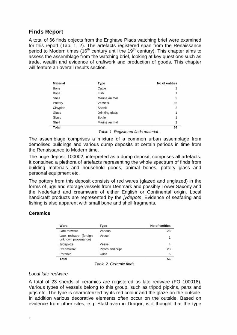
A total of 66 finds objects from the Enghave Plads watching brief were examined for this report (Tab. 1, 2). The artefacts registered span from the Renaissance period to Modern times (16th century until the 19th century). This chapter aims to assess the assemblage from the watching brief, looking at key questions such as trade, wealth and evidence of craftwork and production of goods. This chapter will feature an overall results section.
The assemblage comprises a mixture of a common urban assemblage from demolised buildings and various dump deposits at certain periods in time from the Renaissance to Modern time.
The huge deposit 100002, interpreted as a dump deposit, comprises all artefacts. It contained a plethora of artefacts representing the whole spectrum of finds from building materials and household goods, animal bones, pottery glass and personal equipment etc.
The pottery from this deposit consists of red wares (glazed and unglazed) in the forms of jugs and storage vessels from Denmark and possibly Lower Saxony and the Nederland and creamware of either English or Continental origin. Local handicraft products are represented by the jydepots. Evidence of seafaring and fishing is also apparent with small bone and shell fragments.
Ceramics
Ware Type No of entities
Late redware Various 23
Late redware (foreign unknown provenance)
Vessel 1
Jydepotte Vessel 4
Creamware Plates and cups 23
Porelain Cups 5
Total 56
Table 2. Ceramic finds.
Local late redware
A total of 23 sherds of ceramics are registered as late redware (FO 100018). Various types of vessels belong to this group, such as tripod pipkins, pans and jugs etc. The type is characterized by its red colour and the glaze on the outside. In addition various decorative elements often occur on the outside. Based on evidence from other sites, e.g. Stakhaven in Dragør, is it thought that the type
Material Type No of entities
Bone Cattle 1
Bone Fish 1
Shell Marine animal 2
Pottery Vessels 56
Claypipe Shank 2
Glass Drinking glass 1
Glass Bottle 1
Shell Marine animal 2
Total 66
Table 1. Registered finds material.

iii
found use around the year 1500.16 The urbanization related to industrialization led to the abolishment of the type, as it was a typical handmade product made according to traditional standards that could not compete with industrial products such as creamware or more prestigious products such as porcelain and glass.
Foreign redware
A single sherd of late redware seems to have different provenance (FO 10021). However due to limits in resources, identifying it was not prioritized.
Jydepotte
A total of 4 sherds of ceramics are registered as jydepots (FO 100020). The sherds all belongs to storage jars and similar vessels related to the household. The traditional interpretation of the origin of this type of pottery states that it originates from Jutland, where they began producing it a few decades before 1500. On Zealand the type did not come in use until a few decades later. As it was a typical handicraft product made by women in the rural part of the country the technique and variety of products remained practically the same until the type was phased out around the year 1900.17
Creamware
A total of 23 sherds (FO 100019) are registered as creamware (Danish: stengods). This type, which has significant resemblance with faience and porcelain, was predominantly used for tableware. The spectre of products includes plates, cups, dishes, jugs and small jars etc. The retrieved sherds demonstrate a similar picture of the product variety.
The invention of this fabric took place in Staffordshire in England, but was improved by Josiah Wedgwood around 1760. Vast amounts of the product was produced and copied throughout Europe. In Denmark the leading manufacturer was for many years Kastrup Fajancefabrik. Creamware is still produced in Europe today.18
Porcelain
A total of 5 sherds (FO 100022) are registered as porcelain. Porcelain was predominantly used for tableware and for ornamental purposes. The spectre of products includes plates, cups, dishes, jugs and small jars, ice coolers and figurines etc. The retrieved sherds demonstrate this, as they all represent small coffee or tea cups.
Porcelain, which was invented in China in the 7th century, was the epitome of prestige until the European production began in the beginning of the 18th century. But still today it is regarded as much more luxurious than faience and other fabrics.
The types found are all Royal Danish Musselmalet or copies hereof. The Danish mussel porcelain, which was inspired by a similar fabric manufactured in Meissen
16 Liebgott 1979. 17 Den Store danske Encyklopædi – opslaget jydepotte. 18 Den Store danske Encyklopædi – opslaget stengods.

iv
since the 1740s, came in production at the Royal Danish Copenhagen in 1775 and is still produced today.19
Clay pipe
A total of 2 clay pipe fragments were found (FO 10009). They are both shanks without any decoration. It is not known exactly when smoking was introduced in Denmark. However, it is suggested that it was in Elsinore in the later part of the 16th century. In the beginning of the 17th century, in 1606 specifically, an estate belonging to a deceased citizen who sold clay pipes for a living, mentions clay pipes.20
Animal bones
A total of 4 bones or shell fragments are registered (FO 100009, FO 100011, FO 100015, FO 100016).
Cattle
A single bone fragment (FO 100015) is identified as cattle, Bos Taurus. It is fragmented costae (rib), which shows sign of slaughter (saw).
Fish
A single bone fragment is identified as fishbone (FO 100011), Gadidae sp. It is fragmented Vertebrae thoracicae (vertebrae).
Shellfish
A total of two shell fragments the shellfish group. A fragmented shell of a Blue Mussel, Mytilus edulis, and an oyster shell, Ostreidae sp. was retrieved.
Glass
A total of two glass fragments were retrieved at Enghave Plads (FO 100006, FO 100007).
FO 100006 is a fragment of the side of a transparent drinking glass, probably mouth blown. Its type and origin was not identified.
FO 100007 is a fragment of a green bottle glass. It is probably industrially manufactured, but neither type nor origin was identified.
19 Den Store danske Encyklopædi – opslaget porcelæn. 20 Bardenfleth 2002 p. 25.

v
List of finds
ID Name Material Type Number Dating
100004 Clay pipe Pipe clay Clay pipe 2 Post medieval
100006 Drikkeglas Glass Drinking glass 1 Post medieval
100007 Flaskeglas Glass Bottle 1 Post medieval
100009 Muslingeskal Shell Seashell 1 Post medieval
100011 Fiskeknogle Animal bone Fish bone 1 Post medieval
100015 Kvæg Animal bone Mammal bone 2 Post medieval
100016 Østerskaller Shell Seashell 2 Post medieval
100018 Late redware Ceramic Sherd 23 Post medieval
100019 Creamware Ceramic Sherd 23 Late post-medieval
100020 Jydepots Ceramic Sherd 4 Late post-medieval
100021 Late redware Ceramic Sherd 1 Post medieval
100022 Porcelain Ceramic Sherd 5 Late post-medieval