Embed Size (px)
Citation preview
Studia Quaternaria, vol. 36, no. 1 (2019): 19–43 DOI: 10.24425/sq.2019.126377
ENVIRONMENTAL HISTORY OF THE CSORNA PLAIN (WESTERN DANUBE PLAIN, NW HUNGARY) FROM THE LATE GLACIAL TO THE LATE HOLOCENE AS SEEN FROM DATA OF MULTIPROXY
GEOARCHAEOLOGICAL INVESTIGATIONS
Tünde Törőcsik, Sándor Gulyás*, Pál Sümegi, Balázs Sümegi, Dávid Molnár, Réka Benyó-Korcsmáros
Departament of Geology and Paleontology, University of Szeged, 2-6 Egyetem u., Szeged 6722, Hungary; e-mails: [email protected]; [email protected]; [email protected]; [email protected]; [email protected]* corresponding author
Abstract:This study presents the results of a comprehensive geoarchaeological study implemented at an archeological site cover-ing ca. 5 ha near the city of Csorna on the NW part of the Danube Plain, NW Hungary. The site itself exposed a complex fluvial system of an ice age creek with near bank and overbank areas (levee, point bar, back swamp). Spatial distribution of archeological features allowed for the interpretation of differential use of the fluvial landscape by different cultures. According to our data, the referred fluvial system must have emerged during the Late Glacial. At this time, creeks orig-inating from hills to the SE followed a uniform NW trajectory. From the Holocene, small creeks were beheaded turning into inactive flood channels. It was the time when the gradual infilling of the floodplain started. Alternating layers of floodwater coarses and floodplain fines mark recurring floods at our site. These could have been correlated with cooler, wetter climatic phases of the North Atlantic, Western Europe and high stands in Central European lakes. Highest floods are recorded during the Late Bronze and Iron Ages besides the Neolithic. Pollen data enabled us to make inferences on the vegetation as well.
Key words: fluvial geoarchaeology, environmental history, flood cycles, Danube Plain, NW Hungary
Manuscript received 10 December 2018, accepted 26 February 2019
INTRODUCTION
Rescue excavations along the Győr-Csorna 85 freeway have yielded numerous archeological features and arte-facts from the time of the Neolithic (Raczky, 2007) to the Ottoman Age (Nagy, 2012; Takács, 2008; Tomka, 1996, 2008a, b; Pesti, 2016). One of the studied sites near the city of Csorna known as Lórét with an excavated surface of 50,000 m2 has yielded the largest number of artefacts displaying a unique spatial pattern both vertically and hor-izontally. Vertically alternating layers with rich and no ar-cheology has been documented at the site. Nevertheless, features and artefacts discovered seem to cover the entire time frame from the Neolithic to the Middle Ages.
The uppermost archeological horizon yielded more than 1,800 features dated to the Early Middle Ages and the
Migration Age on an area of 51,000 m2. This was under-lain by a horizon completely void of archeology. The next dark grey settlement horizon covering an area of 11,000 m2
yielded 267 Neolithic and Bronze Age features. Probe maps have been prepared via geoarchaeological coring (Sümegi, 2001; Sümegi et al., 2012). In addition, the actual excavation was continuously monitored and sampled for geoarchaeolog-ical investigations from the start of the excavations (Sávai et al., 2015). This also enabled us to construct on-site geolog-ical profiles and discover ancient geological, hydrological features which would have gone unnoticed otherwise.
This study is about to present the findings of a complex multiproxy geoarchaeological study implemented on the ex-cavation site covering ca. 5 ha, ranging from geomorpho-logical studies to sedimentological, geochemical, paleoeco-logical investigations. A multidisciplinary evaluation of the

20 T. TÖRŐCSIK et al.
results yielded the most reliable paleoenvironmental and en-vironmental historical reconstruction for the area available so far from the time of the Pleniglacial to the Late Holocene.
LOCATION, GEOGRAPHICAL, CLIMATIC ENDOWMENTS OF THE STUDY SITE
The study site is found at the southern fringe of the Danube Plain (Little Hungarian Plain) in the area of the so-called Csorna Plain (Fig. 1). The area itself is found in a relatively higher morphological position occupying a fossil alluvial fan (Ferenczi, 1924; Jaskó, 1935; Sümeghy, 1944; Pécsi, 1959, 1962; Bendefy, 1977).
According to the literature, the geological evolution of the area was controlled by one of the largest tributaries of the Danube the Raab or Rába River having a total length of 283 km and a watershed area of 10,720 km2 (Sümeghy, 1944; Somogyi, 1961; Fodor et al., 2005; Lovász, 2007; Gábris and Nádor, 2007; Zámoly et al., 2010). Using data on Quaternary fluvial deposit thickness and certain fos-sils low resolution reconstructions were made regarding
the fluvio-morphological evolution mostly focusing on the larger area of the Danube Plain (Jaskó, 1935; Sümeghy, 1944; Kordos and Krolopp, 1990). A relatively recent work pointed to the importance of differential subsidence of sub-basins in the Danube Plain as a major driver of land-scape evolution resulting in the beheading of creeks with a SE-NW flow from the Late Glacial and creating the mod-ern hydrological network (Sávai et al., 2015).
Today the area of the Csorna Plain is under intensive cultivation. As a result, both the natural vegetation and fauna as well as soils must have been altered following the 19th century drainage works and river regulations resulting the drainage of marshlands, lowering of the groundwater table, construction of roads, railways, irrigation and drain-age canals as well as the creation of extensive arable lands, pastures and orchards. Consequently, pre-industrial vegeta-tion, soils, and fauna could be potentially inferred from cli-matic parameters of the area alone (Szabó, 2005). Surface planation connected to crop farming created a relatively even surface in the Csorna Plain losing information on the original geomorphological endowments. These features can be studied only in cross-sections of rescue excavations
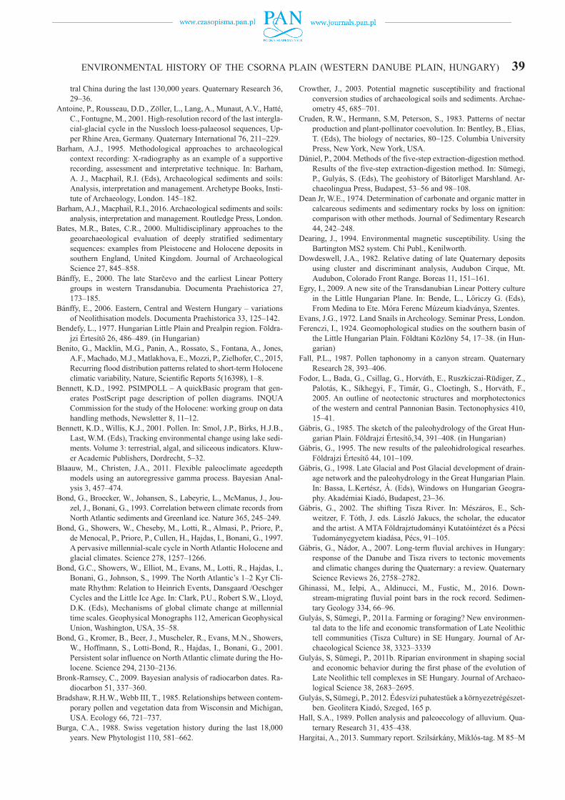
Fig. 1. Location (a), paleohydrological conditions preceding the 19th century river regulations (b) and geomorphology of the study site Csorna-Lórét (d) and its surroundings of the Danube Plain (c).
ENVIRONMENTAL HISTORY OF THE CSORNA PLAIN (WESTERN DANUBE PLAIN, HUNGARY) 21in connection with construction of road networks following the removal of the modern topsoil.
The modern climate of the area is Continental with milder winters and cooler summers than the central part of the Carpathian Basin. It is due to the stronger Oceanic Influences seen in the relatively high rate of annual pre-cipitation (540 mm), which can reach 650–700 mm as well (Hungarian Meteorological Survey). The average annual temperatures are also somewhat lower (10.3°C).
MATERIAL AND METHODS
The workflow and methodology of geoarchaeologi-cal investigations followed the protocol established for Geoarchaeological studies at the Department of Geology and Paleontology, University of Szeged, Hungary (Sümegi, 2001, 2002, 2003, 2013).
Geomorphological investigations
Drone-made aerial photographs of the Archeo Art Ltd. taken at a lower (75 m) and higher (125 m) altitudes have been handed over for geomorphological evaluations (Pesti, 2016; Sümegi, 2016). In addition, historical maps of the area have also been considered. The most important are the ones of the First (1782) and Second (1869) Austrian Military Surveys (Timár et al., 2006, 2011). Furthermore, the hydrological map of the Carpathian Basin preceding the 19th century river regulations have also been considered, as it gives a relatively reliable view of the distribution of permanently and tempo-rary inundated areas (Fig. 1). Finally, high resolution digital elevation models of the wider vicinity of the site have been prepared and analyzed (Sávai et al., 2015; Sümegi, 2016).
In the next part the several hundred-meter-long sec-tions at the archeological excavation site have been cleaned every 20 m yielding geological profiles, which were visu-ally described and photographed following the previously mentioned protocol (Sümegi, 2002, 2003). Position and elevation of the geological profiles as well as the identi-fied geological horizons have been recorded enabling the clarification of the original position of geomorphological units. The detailed on-site visual sedimentary facies and sequence analysis have clearly outlined a restricted dis-tribution of anthropogenic and cultural deposits confined mainly to small archeological features (pits, graves, wells, postholes) (Barham, 1995; Barham and Macphail, 2016). Consequently, the settlement strategy and patterns of for-mer cultures as well as the remaining attesting cultural deposits were controlled by the geological, geomorpho-logical endowments of the site and its vicinity from the Late Glacial to the modern times (Bates and Bates, 2000; Shackley, 1975; Rapp, 1975; Rapp et al., 1974; Rapp and Gifford, 1982; Starkel, 1991; Starkel et al., 2009). Thus, following the identification, delineation and visual de-scription of the individual geomorphological units uniform chronological, sedimentological, geoarchaeological, envi-
ronmental historical investigations have been implemented following the mentioned workflow. The created cross-sec-tions were further refined by findings of complementary probe coring down to the fluvial gravelly sandy base.
Field sampling
After cleaning the surface of the individual profiles, major stratigraphic units have been identified and de-scribed. Wet and dry colors were determined on-site using the Munsell Color Chart (Munsell, 2000). The lithostrati-graphic description of the profiles followed the system of Troels-Smith (1955). An on-site make-shift cross-section was created refined later off-site. Sampling sites were cho-sen accordingly, where sediment thickness as well as the largest number of identified stratigraphic units were found. The surficial outcropping profile of ca. 1.7 m was further lengthened to a depth of 3.5 m via undisturbed coring. The surface profile was subsampled at 1–4 cm increments for geoarchaeological investigations. Relatively wider sam-pling intervals of 10 cm were chosen for the core to ensure enough amounts of samples.
Radiocarbon dating
The uppermost 2.5 m part of the studied profile yielded mollusk shells of autochthonous preservation suitable for re-liable 14C analysis. Eleven samples (mussel, land snail shells, charcoal) have been chosen for 14C dating. Certain herbivo-rous gastropods are known to yield reliable ages for dating deposits of the past 40 kyr with minimal error on the scale of perhaps a couple hundred years (Pigati et al., 2004, 2010, 2013; Sümegi and Hertelendi, 1998; Xu et al., 2011; Újvári et al., 2014). The preparation of the shell carbonate samples and the actual steps of the measurement followed the methods of Hertelendi et al. (1989, 1992) and Molnár et al. (2013). Shells were ultrasonically washed, and dried at room temperature. Surficial contaminations and carbonate coatings were re-moved by pretreatment with weak acid etching (2% HCl) before graphitization. The cleaning of charcoal followed the ABA protocol. Measurements were done in the interna-tionally referenced AMS laboratory of Seattle, WA, USA. Conventional radiocarbon ages were converted to calendar ages using the software Oxcal 4.2 online (Bronk-Ramsey, 2009) and the most recent Intcal13 calibration curve (Reimer et al., 2014). Calibrated ages are reported as age ranges at the 2-sigma confidence level (95.4%).
OSL dating
Results of 14C measurements were complemented by OSL analysis of samples taken from two successive geo-logical horizons. Luminescence samples were taken by hammering and extracting 15 cm long metal tubes into the previously cleaned sediment wall, and by collecting the sur-
22 T. TÖRŐCSIK et al.
rounding material in a radius of 30 cm for dose rate deter-mination. Preparation of the samples as well as the mea-surement protocol followed that presented in Szujó et al. (2017). Measurements were done at the OSL Laboratory of the Department of Physical Geography and Geoinformatics, University of Szeged.
Age-depth modeling and SR calculations
Calibrated 14C ages and OSL ages were used to cre-ate age-depth models. Bayesian modelling was performed using gamma distributions as prior information on accu-mulation rates. Bacon (Blaauw and Christen, 2011) mod-els the accumulation rates of many equally spaced depth sections based on an autoregressive process with gamma innovations. Inverse AR (sedimentation times expressed as year/cm) were estimated from 42 to 48 mln Markov Chain Monte Carlo (MCMC) iterations, and these rates form the age-depth model. AR was first constraint by prior informa-tion: acc.shape = 1.5 and acc. mean = 50 for the beta distri-bution, a memory mean = 0.7 and memory strength = 4 for beta distribution describing the autocorrelation of inverse AR. All input data were provided as 14C y BP and the model used the northern hemisphere IntCal13 calibration curve (Reimer et al., 2014) to convert conventional radiocarbon ages to calendar ages expressed as cal. BP. Age modelling was run to achieve a 1-cm final resolution.
Sedimentation rates (mm/year) have been calculated using equation
AR = d2 – d1/a2 – a1 × 1000 (1)
where d1-2 are consecutive depths at 1-cm intervals and a1, a2 are mean model ages. 95% confidence ranges were also calculated using the same equation but a1, a2 here rep-resents lower and upper 95% CI.
Magnetic susceptibility analysis
Environmental magnetic analyses were carried out on bulk samples (An et al., 1991; Crowther, 2003; Harvey et al., 2003; Zhou et al., 2004). Samples were taken at 1–4 cm intervals. Prior to the start of the measurement, all samples were crushed in a glass mortar after weighing. Then sam-ples were cased in plastic boxes and dried in air in an oven at 40°C for 24h. Afterwards, magnetic susceptibilities were measured at a frequency of 2 kHz using an MS2 Bartington magnetic susceptibility meter with a MS2E high resolution sensor (Dearing, 1994). All of the samples were measured three times and the average values of magnetic susceptibil-ity were computed and reported.
Sedimentological analysis
Grain-size composition was determined using the Mie method. Samples were pre-treated with 1 M HCl and H2O2
to remove CaCO3 and organic matter, respectively. For a more detailed description of the pre-treatment process, see Konert and Vandenberghe (1997). All the samples were measured for 42 size intervals between 0.0001 and 0.5 mm using an Laser Particle Size Analyzer type Easy Sizer 2.0 and Fritsch sieves at the Geoarchaeological and Paleoecological Lab of the Department of Geology and Paleontology, University of Szeged, Hungary.
Loss-on ignition
For LOI examination sub-samples were taken at every 1–4–10 cm intervals and the loss on ignition method was ap-plied, commonly used for the analysis of organic matter and carbonate content of calcareous sediments (Dean, 1974).
Geochemical analysis of major and selected trace elements
A new, so-called sequential extraction method (Dániel, 2004) with a long-established history in the analysis of geo-chemical composition of lacustrine sediments was adopted in this study. From the full procedure, the step of water ex-traction for unseparated samples was enough to suit our an-alytical needs, as it was shown by previous works (Dániel, 2004; Sümegi et al., 2013) the most important elements reflecting major palaeohydrological and palaeoecological changes are mobilized during the step of water extraction. The procedure followed the following steps:
Distilled water was purified using a Millipore fife 5 Plus Water Purification System. 100 ml double dis-tilled water was added to 1.0 g sample and was shaken for 1 hour. Concentration of elements of Na, K, Ca, Mg, Fe were determined via flame AAS using conventional standards of known concentrations using a Perkin-Elmer 100 AAS spectrometer (Dániel, 2004). Plotting of the sedimentological and geochemical data against depth was done using the software package Psimpoll (Bennett, 1992). Statistical procedures were used to zone the data. Principal components analyses computed on correlation matrices were preformed after logarithmic transforma-tion of the geochemical data (Rollinson, 1993). The sed-imentological and geochemical zones were identified by cluster analysis of principal components by using squared Euclidean distance matrix and Ward aggregation method (Dowdeswell, 1982).
Pollen analyses
Core FT-1 was sampled for pollen at 4-cm intervals. Samples of 4 cm3 wet sediment were prepared for pol-len analysis in the pollen laboratory of the Department of Geology and Paleontology at Szeged University using standard methods and micro-sieving at 10 um (Bennett and Willis, 2001). Lycopodium spore tablets of known con-

ENVIRONMENTAL HISTORY OF THE CSORNA PLAIN (WESTERN DANUBE PLAIN, HUNGARY) 23
centrations were added to each sample (Stockmarr, 1971) to work out pollen concentrations. Pollen and spores were identified and counted under light microscope at 400–1000× magnification. Minimum 300 pollen grains were counted. In several cases low pollen concentrations and poor pollen preservation was encountered. A sample was considered pollen-sterile if less than 80 grains were found. In such cases only the observed taxa were recorded. For the identification of pollen and spores the reference database at the of the Department of Geology and Paleontology at Szeged University and pollen atlases and keys were used (Moore et al., 1991; Reille, 1993). Statistical analysis and plotting of the pollen data were done using the software package Psimpoll (Bennett, 1992).
Malacological analyses
Mollusk shells and charcoals were collected from 4 cm thick subsamples taken at regular intervals throughout the
section. Samples for malacological analyses were dispersed in water and wet-sieved through 0.5 mm meshes. After sieving, mollusk shells were dried, sorted and identified under a stereo dissecting microscope at magnifications of 6–50 times.
The malacofauna was divided into different paleoeco-logical groups following the paleoecological classifications of Ložek (1964), Krolopp and Sümegi (1995), Sümegi-Krolopp, (2002), Alexandrowicz (2004), Sümegi, (2005). The malacological record was also classified according to the recent geographical distribution of the species (Soós, 1943; Evans, 1972; Kerney et al., 1983; Krolopp, 1983; Welter-Schultes, 2012; Horsák et al., 2015), and based on paleoclimatological indicator roles (Sümegi and Krolopp, 2002; Sümegi, 2005; Sümegi et al., 2013).
Statistical methods were used for the zonation of the data. Principal components analysis computed on correla-tion matrices was performed after arc sine transformation (Zar, 1990) of the malacological data. Correspondence analysis was used for mollusk-based palaeoecological re-
Fig. 2. Aerial view of the excavation site displaying the distribution of archeological features and fluvial sub-facies (a) with a close-up of channel (b) and cyclical floodplain deposits (c–d) (S1 – modern soil, S2 – Bronze Age soil, S3 and S4 – Copper Age and Neolithic soil, FP1 – Late Bronze Age–Early Iron Age floodplain deposits, FP2 – Copper Age–Early Bronze Age floodplain deposits, C – Ice age floodplain deposits (sandy coarse silt).
24 T. TÖRŐCSIK et al.
constructions (Rousseau and Puisségur, 1990; Rousseau, 1991, 2001). The dominance values of certain mollusk spe-cies and those of the given palaeoecological groups are of crucial importance regarding the reconstruction of the prevailing environmental factors (Rousseau and Kukla, 1994; Rousseau and Puisségur, 1999; Moine et al., 2005). Dominance values are based on the calculation of percent-ages from the specimen numbers of species collected from the sample (Ložek, 1964, 1990, 2001; Krolopp, 1973, 1983; Antoine et al., 2001; Alexandrowicz and Dmytruk, 2010).
RESULTS
Geomorphology, lithology
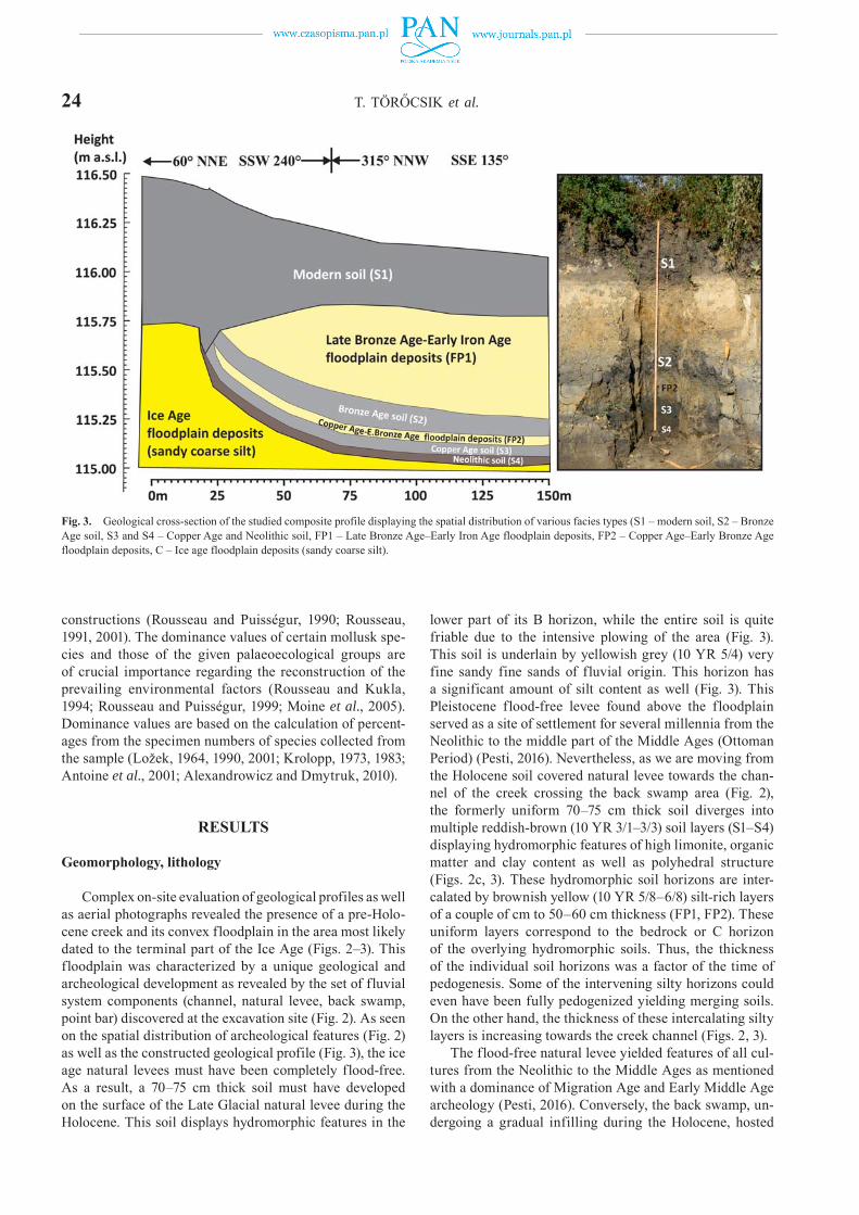
Complex on-site evaluation of geological profiles as well as aerial photographs revealed the presence of a pre-Holo-cene creek and its convex floodplain in the area most likely dated to the terminal part of the Ice Age (Figs. 2–3). This floodplain was characterized by a unique geological and archeological development as revealed by the set of fluvial system components (channel, natural levee, back swamp, point bar) discovered at the excavation site (Fig. 2). As seen on the spatial distribution of archeological features (Fig. 2) as well as the constructed geological profile (Fig. 3), the ice age natural levees must have been completely flood-free. As a result, a 70–75 cm thick soil must have developed on the surface of the Late Glacial natural levee during the Holocene. This soil displays hydromorphic features in the
lower part of its B horizon, while the entire soil is quite friable due to the intensive plowing of the area (Fig. 3). This soil is underlain by yellowish grey (10 YR 5/4) very fine sandy fine sands of fluvial origin. This horizon has a significant amount of silt content as well (Fig. 3). This Pleistocene flood-free levee found above the floodplain served as a site of settlement for several millennia from the Neolithic to the middle part of the Middle Ages (Ottoman Period) (Pesti, 2016). Nevertheless, as we are moving from the Holocene soil covered natural levee towards the chan-nel of the creek crossing the back swamp area (Fig. 2), the formerly uniform 70–75 cm thick soil diverges into multiple reddish-brown (10 YR 3/1–3/3) soil layers (S1–S4) displaying hydromorphic features of high limonite, organic matter and clay content as well as polyhedral structure (Figs. 2c, 3). These hydromorphic soil horizons are inter-calated by brownish yellow (10 YR 5/8–6/8) silt-rich layers of a couple of cm to 50–60 cm thickness (FP1, FP2). These uniform layers correspond to the bedrock or C horizon of the overlying hydromorphic soils. Thus, the thickness of the individual soil horizons was a factor of the time of pedogenesis. Some of the intervening silty horizons could even have been fully pedogenized yielding merging soils. On the other hand, the thickness of these intercalating silty layers is increasing towards the creek channel (Figs. 2, 3).
The flood-free natural levee yielded features of all cul-tures from the Neolithic to the Middle Ages as mentioned with a dominance of Migration Age and Early Middle Age archeology (Pesti, 2016). Conversely, the back swamp, un-dergoing a gradual infilling during the Holocene, hosted
Fig. 3. Geological cross-section of the studied composite profile displaying the spatial distribution of various facies types (S1 – modern soil, S2 – Bronze Age soil, S3 and S4 – Copper Age and Neolithic soil, FP1 – Late Bronze Age–Early Iron Age floodplain deposits, FP2 – Copper Age–Early Bronze Age floodplain deposits, C – Ice age floodplain deposits (sandy coarse silt).
ENVIRONMENTAL HISTORY OF THE CSORNA PLAIN (WESTERN DANUBE PLAIN, HUNGARY) 25
Neolithic and Bronze Age features alone (Fig. 2). These lower lying areas with temporal inundation must have been suitable for settling only in drier climatic periods when the groundwater table was sufficiently low. These long-lasting desiccation periods of the floodplain are put to the termi-nal part of the Middle Neolithic and opening of the Late Neolithic (7,200–6,600 cal years BP or 5,200–4,600 cal years BC) as well as the terminal part of the Copper Age and beginning of the Bronze Age (5,100–4,700 cal years BP or 3,100–2,700 cal years BC). Numerous ditches were created around the natural heights of the floodplain during the 10th–11th centuries AD hosting an Arpadian Age village (Fig. 2). This implies the complete infill of the floodplain and back swamp areas by then also putting the floods not only closer to the natural levees horizontally but verti-cally as well requiring adequate flood protection measures. Similar systems of double, triple ditches dated to the 10th–15th centuries AD are known from the wider surroundings (Takács, 2000).
This canal system was constantly cleaned and main-tained until the 15th–16th centuries (Persaits et al., 2015). South of our study site at ca. 10 km several Iron Age Hall-statt Culture settlement sites were documented near Szil-sárkány–Miklóstag (Hargitai, 2013) and Győr-Mén főc-sanak–Széles-földek (Ilon, 2011). At these sites flood-free natural levees found above the ice age floodplain are also surrounded by Iron Age drainage channels to ensure both flood as well as groundwater protection perching the sur-face at high stands on the floodplain. However, communi-ties settling at our study site have used the creek channel itself as well creating wells. These wells are following the trajectory of the creek bed in accordance with the local groundwater flow directions.
Chronology from 14C data
Based on the gained 14C ages the lowermost 1 m of the studied profile accumulated during the Late Glacial, while the uppermost 2.5 m represents the Holocene (Fig. 4,
Table 1). The uppermost disturbed 0.4 m of the profile is confined to the past 1,500–2,000 years based on our re-sults. So, the interval spanning the depths of 2.5 and 0.4 m must represent the period from the Pleistocene/Holocene boundary to the past 2000 years (Fig. 4).
OSL based chronology
Samples taken for OSL analysis derive from floodplain deposits overlying soils, which developed during the turn of the Early and Middle Bronze Ages inferred from 14C data. The resulting dates are in line with those for 14C data and constructed age-depth models (Table 2, Fig. 4). Namely, the uppermost underlying paleosol must have developed during the middle part of the Bronze Age (16th century BC).
Sedimentological and geochemical investigations
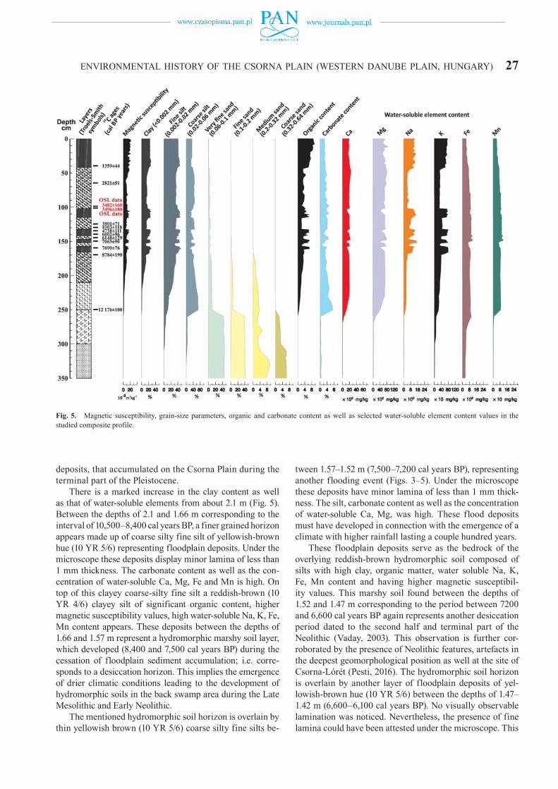
Altogether 126 samples were analyzed out of which 17 samples correspond to the interval between 16,800 and 8,800 cal years BP. 109 samples represent the last 8,800 years, respectively. Based on the observed changes in grain-size, LOI and geochemical parameters (Table 3, Fig. 5) the first zone between the depth of 3.5 and 2.5 m is characterized by a clear prevalence of sand size particles of yellowish grey hue (10 YR 5/3).
A very fine sandy fine sand gives the base display slight cross-bedding between 3.5–3 m. It is overlain by silty dark grey (10 YR 4/1) very fine sandy fine sand with 0.5 cm laminas forming parallel bedding (3–2.5 m). Based on the documented and observed characteristics of the sediment this zone clearly represents the fluvial stage of the evolution of the area dated between 16,500 and 12,200
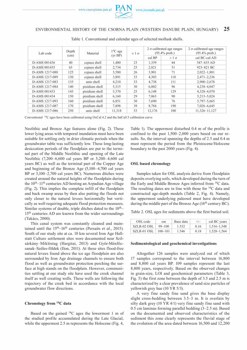
Table 1. Conventional and calendar ages of selected mollusk shells.
Lab code Depth (cm) Material 14C age
(yr BP) ± 1 ơ2 ơ calibrated age ranges
(95.4% prob.)2 ơ calibrated age ranges
(95.4% prob.)cal BP ± 1 ơ cal BC-cal AD
D-AMS 001436 40 cepaea shell 1,480 23 1,359 44 547–635 ADD-AMS 001435 65 cepaea shell 2,734 25 2,821 51 923–821 BCD-AMS 1217-088 125 cepaea shell 3,580 26 3,901 71 2,022–1,881D-AMS 1217-089 130 cepaea shell 3,891 33 4,303 118 2,471–2,236D-AMS 1217-083 135 unio shell 4,210 33 4,738 111 2,900–2,678D-AMS 1217-084 140 pisidium shell 5,315 30 6,002 96 4,238–4,047D-AMS 001433 145 pisidium shell 5,370 25 6,148 129 4,328–4,070D-AMS 001434 150 pisidium shell 6,160 29 7,063 90 5,213–5,024D-AMS 1217-093 160 pisidium shell 6,851 30 7,690 76 5,797–5,665D-AMS 1217-087 170 pisidium shell 7,898 39 8,784 190 7,026–6,645D-AMS 1217-086 250 unio shell 11,318 53 12,176 100 11,326–11,127
Conventional 14C ages have been calibrated using OxCal 4.2 and the IntCal13 calibration curve
Table 2. OSL ages for sediments above the first buried soil.
OSL code cm Base data +/– cal BC yearsSZLR-02 OSL 99–100 1.532 0.16 1,516–1,548SZLR-01 OSL 100–101 1.546 0.18 1,528–1,564
26 T. TÖRŐCSIK et al.
cal years BP; i.e. the Late Glacial. The convex floodplain must have appeared after the accumulation of this ice age horizon seen as a significant drop in the sand content of the Holocene deposits (Fig. 5). There is a parallel increase in the silt, carbonate, water soluble Ca, Mg content as well as the organic content and elements bounded to organics
(Fig. 5). Thus, the earliest phase of the Holocene (2.5–2.1 m, 12,200–10,500 cal. years BP) is characterized by the accumulation of a carbonate-rich yellowish brown (10 YR 5/6) sandy silts (Table 3). These sandy silt is composed of 1 mm thick laminas. This bed might have developed as a result of the fluvial erosion and redeposition of loess
Fig. 4. Constructed age-depth model and inverse accumulation rates with 95% confidence intervals using 14C and OSL age data.
Table 3. Color, structure and lithology of the encountered sedimentary units of the studied composite profile.
Depth (cm) Age (cal BP) Color Munsell color-scale Troels-Smith category Structure0–42 last 1,500/2,500 dark brow 10 YR 3/2 As3Sh1 friable soil
102–42 3,500–1,500/2,500 yellowish brown 10 YR 5/6 Ag2As2 very fine laminated115–102 3,700–3,500 reddish brown 10 YR 4/6 As2Ag1Sh1 polihedric soil132–115 4,500–3,700 yellowish brown 10 YR 5/6 Ag2As2 very fine laminated142–132 6,100–4,500 reddish brown 10 YR 4/6 As2Ag1Sh1 polihedric soil147–142 6,600–6,100 yellowish brown 10 YR 5/6 Ag2As2 very fine laminated152–147 7,200–6,600 reddish brown 10 YR 4/6 As2Ag1Sh1 polihedric soil157–152 7,500–7,200 yellowish brown 10 YR 5/6 Ag2As2 very fine laminated166–157 8,400–7,500 reddish brown 10 YR 4/6 As2Ag1Sh1 polihedric soil210–166 10,500–8,400 yellowish brown 10 YR 5/6 Ag2As2 very fine laminated250–210 12,200–10,500 light grey 10 YR 5/1 Ga1Ag2As1 parallel laminated300–250 14,300–12,200 dark grey 10 YR 4/1 Ga4 laminated350–300 16,500–14,300 greyish yellow 10 YR 5/3 Ga3Gs1 cross-laminated
ENVIRONMENTAL HISTORY OF THE CSORNA PLAIN (WESTERN DANUBE PLAIN, HUNGARY) 27
deposits, that accumulated on the Csorna Plain during the terminal part of the Pleistocene.
There is a marked increase in the clay content as well as that of water-soluble elements from about 2.1 m (Fig. 5). Between the depths of 2.1 and 1.66 m corresponding to the interval of 10,500–8,400 cal years BP, a finer grained horizon appears made up of coarse silty fine silt of yellowish-brown hue (10 YR 5/6) representing floodplain deposits. Under the microscope these deposits display minor lamina of less than 1 mm thickness. The carbonate content as well as the con-centration of water-soluble Ca, Mg, Fe and Mn is high. On top of this clayey coarse-silty fine silt a reddish-brown (10 YR 4/6) clayey silt of significant organic content, higher magnetic susceptibility values, high water-soluble Na, K, Fe, Mn content appears. These deposits between the depths of 1.66 and 1.57 m represent a hydromorphic marshy soil layer, which developed (8,400 and 7,500 cal years BP) during the cessation of floodplain sediment accumulation; i.e. corre-sponds to a desiccation horizon. This implies the emergence of drier climatic conditions leading to the development of hydromorphic soils in the back swamp area during the Late Mesolithic and Early Neolithic.
The mentioned hydromorphic soil horizon is overlain by thin yellowish brown (10 YR 5/6) coarse silty fine silts be-
tween 1.57–1.52 m (7,500–7,200 cal years BP), representing another flooding event (Figs. 3–5). Under the microscope these deposits have minor lamina of less than 1 mm thick-ness. The silt, carbonate content as well as the concentration of water-soluble Ca, Mg, was high. These flood deposits must have developed in connection with the emergence of a climate with higher rainfall lasting a couple hundred years.
These floodplain deposits serve as the bedrock of the overlying reddish-brown hydromorphic soil composed of silts with high clay, organic matter, water soluble Na, K, Fe, Mn content and having higher magnetic susceptibil-ity values. This marshy soil found between the depths of 1.52 and 1.47 m corresponding to the period between 7200 and 6,600 cal years BP again represents another desiccation period dated to the second half and terminal part of the Neolithic (Vaday, 2003). This observation is further cor-roborated by the presence of Neolithic features, artefacts in the deepest geomorphological position as well at the site of Csorna-Lórét (Pesti, 2016). The hydromorphic soil horizon is overlain by another layer of floodplain deposits of yel-lowish-brown hue (10 YR 5/6) between the depths of 1.47–1.42 m (6,600–6,100 cal years BP). No visually observable lamination was noticed. Nevertheless, the presence of fine lamina could have been attested under the microscope. This
Fig. 5. Magnetic susceptibility, grain-size parameters, organic and carbonate content as well as selected water-soluble element content values in the studied composite profile.
28 T. TÖRŐCSIK et al.
layer is characterized by a high carbonate and silt content as well as higher concentration of water-soluble Ca and Mg. This horizon again representing a period of higher rainfall was correlated with the terminal part of the Neolithic and the opening of the Copper Age (Vaday, 2003).
The next horizon between the depths of 1.42 and 1.32 m corresponding to the period between 6,100 and 4,500 cal years BP is represented by another reddish brown (10 YR 4/6) hydromorphic soil of similar geochemical and grain-size properties as the previous ones. This soil horizon again represents another desiccation period of the floodplain dated to the second half of the Copper Age and the open-ing of the Bronze Age (Vaday, 2003). Early Bronze Age artifacts found in the lowermost geomorphological position further corroborate this presumption.
The hydromorphic soil horizon is overlain by yellowish brown (10 YR 5/6) coarse silty fine silts between the depths of 1.32 and 1.15 m. These flood deposits represent the period between 4,500 and 3,700 cal years BP. Sedimentological and geochemical characteristics of these deposits are the same as the previously recorded flood deposits. Again, we can presume the emergence of a rainy period during the terminal part of the Early Bronze Age and the beginning of the Middle Bronze Age (Vaday, 2003). Based on this in-formation it is clearly visible that the climate of the Bronze Age was by no means uniform. Rather it was made up of alternating humid and dry periods.
Another hydromorphic soil appears dated to the second half of the Middle Bronze Age between the depths of 1.15 and 1.02 m (3,700 and 3,500 cal years BP). The age of this soil horizon is corroborated by results of OSL measure-ments from the overlying flood deposits of coarse silty fine silts between the depths of 1.02 and 0.42 m (3,500–1,500 cal years BP) (Figs. 3–5). On the basis of available 14C and OSL dates, this flood horizon must have emerged during the Late Bronze Age–Early Iron Age. The uppermost 0.42 m of the profile corresponding to the topmost soil must have developed during the past 2,400–2,500 years as testified by the rich Migration Age and Middle Age archeology. However, due to modern disturbance and alteration of this soil the stratigraphic interrelations of the floodplain depos-its and the topmost soil cannot be reliably studied. In other parts of the Danube Plain, found in a deeper geomorpholog-ical position cyclical alterations of floodplain deposits and soils was recorded for the past 3,000 years as well (Szűcs and Szűcs, 2006). So, we may presume the transformation of the originally hydromorphic soils into chernozem type soils as a result of agricultural activities. Nevertheless, nu-merous flood cycles representing drier and humid periods of the Holocene could have been identified in our profile during the Holocene via the evaluation of sedimentological and geochemical properties of the studied samples.
Sedimentation rates
Based on the calculated SR values for the total profile, 1 cm interval must represent 47–50 years. However, this
value changes to 30 years for the uppermost part corre-sponding to the second half of the Holocene. Consequently, the attained temporal resolution of environmental histori-cal data from 8,000 years ranged between 30 and 60 years enabling us to infer decadal fluctuations in the sedimento-logical cycles. A wider sampling from the core correspond-ing to the period of the Early Holocene and Late Glacial allowed for lower centennial resolution only.
Sedimentation rates (SR) are relatively high in the sandy layers corresponding to high-energy fluvial phases (SR: 0.24 mm/y) (Fig. 4). These are intervened by signifi-cant drops to values of 0.06–0.09 mm/y corresponding to dark brown, organic- and clay-rich horizons. Buried soils are intercalated by yellowish brown silty layers of relatively higher SR values (0.16–0.56 mm/y). These must correspond to paleo flood cycles reaching the back swamp area of the floodplain.
Pollen analysis
Although the entire profile was subsampled for pollen analysis at 4 cm intervals only the part between 2.1 and 0.4 m yielded pollen grains suitable for evaluation. Samples needed to be extracted for pollen five times in order to attain the minimum acceptable limit of 300 pollen grains. Due to the presence of intercalating finer flood deposits within the hydromorphic soils sporadic samples at 2 cm intervals were also taken yielding a total of 47 samples for final analysis. Preservation was exceptionally poor posing problems of selective pollen preservation in the final eval-uation. Pollen composition was evaluated for the period between 10,500 and 2,500–2,000 cal years BP based on available 14C data. With the help of statistical methods 7 pollen zones could have been identified (Figs. 6, 7, Table 4).
The first zone is found between the depths of 2.1 and 1.8 m (10,500–9,300 cal years BP). This zone is prevailed by pine grains representing the Pinus taxa, most likely Scots pine (Pinus sylvestris). The other dominant element of the flora was birch (Betula). Although Pinus is notori-ous for its long-distance transport and high productivity (Litchi-Federovich and Ritchie, 1968; Bradshaw and Webb, 1985), values of between 60–70% of the total pollen (t.p.) suggests local presence of this taxon (Cruden et al., 1983). As the ratio of AP was higher than 80% the presence of a closed woodland can be assumed forming a mixed taiga (Prentice, 1985; Prentice et al., 1992, 1996; Prentice and Webb, 1998; Sugita, 1994; Soepboer et al., 2007; Jacobson and Bradshaw, 1981; Magyari, 2002, 2011; Magyari et. al., 1999, 2000, 2001, 2009, 2010a, b, 2012, 2014) in our study area between 10,500 and 9,300 cal years BP. This woodland must have been dissected by smaller patches of wet mead-ows, ponds harboring higher grassy vegetation.
There is a marked decrease in the ratio of pines from 9,300 cal years BP, while that of AP remained above 80% (Fig. 7, Table 4). The observed changes in the arboreal vegetation with a dominance maximum of oak, elm, alder, lime and hazelnut indicate the emergence of oak-alder-elm

ENVIRONMENTAL HISTORY OF THE CSORNA PLAIN (WESTERN DANUBE PLAIN, HUNGARY) 29
hardwood gallery forests with stands of lime and hazelnut during the Early Holocene at the Preboreal/Boreal bound-ary. In addition, softwood gallery forests of alder and wil-low must have been also present during this period. This change took no more than a couple hundred years. These rapid changes, both in pace and composition, are clearly observable in the records of Bátorliget marshland (Willis et al., 1995), Lake Kis-Mohos (Willis et al., 1997, 1998)
as well as the charcoals of a Sub-Carpathian rock shelter (Sümegi and Náfrádi, 2015).
The referred deciduous woodland with a clear preva-lence of oak developed between 9,300 and 7,600 cal years BP. There is a marked drop in the ratio of oak, elm, lime, alder, hazelnut at 7,600 cal years BP (5,600 cal years BC) parallel with the appearance of beech and hornbeam as well as weed and cereal pollen grains. These changes im-
Fig. 6. Distribution of arboreal pollen taxa in the studied composite profile.
Table 4. Age, lithology, pollen content of the studied composite profile.
cm Age(cal BP years) Lithology Pollen content
0–42 last 2,000 recent soil no pollen remains
42–60 2,600–2,000 alluvial sediment Pinus rich pollen content with weed, cereal, Juglans and NAP dominance peak
112–60 3,600–2,600 hidromorphic soil and alluvil sediment Arbor pollen decline, Juglans pollen appear, weeds, cereal, NAP dominance cycle changed
152–112 7,200–3,600 hidromorphic soil and alluvial sediment Corylus, Quercus, Tilia, Ulmus, Fraxinus dominance decline, but Fagus, Carpinus weeds, cereals dominance increase
157–152 7,600–7,200 alluvial sediment Pinus rich pollen content with first cereals, weeds, Fagus, Carpinus pollen grains
180–157 9,300–7,600 alluvial sediment and hidromorphic soil Corylus, Quercus, Tilia, Ulmus, Fraxinus pollen dominance peak – oak-ash-elm hardwood gallery forest with Alnus–Salix spots
210–180 10,500–9,300 alluvial sediment Pinus–Betula dominated mixed leaved taiga phase350–210 16,500–10,500 fluvial sediment No pollen remains

30 T. TÖRŐCSIK et al.
mediately precede the appearance of the LBK Culture during the Middle Neolithic in Transdanubia (Willis, 2007; Bánffy, 2000, 2006). The ratio of APs decreased below 70% hallmarking the emergence of a more open landscape of forest steppe (Prentice, 1985; Prentice et al., 1992, 1996; Prentice and Webb, 1998; Sugita, 1994; Soepboer et al., 2007; Jacobson and Bradshaw, 1981; Magyari, 2002, 2011; Magyari et al., 1999, 2000, 2001, 2009, 2010a, b, 2012, 2014). This period also marked the appearance of scattered cluster village type Neolithic settlements in our study area as proved by the rich Middle Neolithic archeology discov-ered (Pesti, 2016). Significant settlements of this period are known from the wider surroundings as well (Egry, 2009; Virág and Figler, 2007; Ilon et al., 2006).
The next local pollen zone is found between the depths of 1.52 and 1.12 m (7,200–3,600 cal years BP = 5,200–1,600 cal years BC). This horizon comprises the whole Neolithic and Copper Age as well as the first half of the Bronze Age. Hornbeam and ash that appeared in the Mesolithic (Fig. 7, Table 4) increased continuously and became the domi nant arboreal taxa in the forest from the second part of the Neolithic. From the second part of the Copper Age the weed composition was also altered from its previous stable phase in the Neolithic (Kreuz and Schäfer, 2011; Lososová et al., 2004; Rösch, 1998; Pyš ek et al., 2005; Burga, 1988).
An increasing ratio of an indicator taxon Polygonum avic-ulare characterized the new weed vegetation. The con-tinuous presence of the Lengyel Culture during the Late Neolithic and Early Copper Age must be blamed for the decrease of AP ratio to 50%, thanks to its wide network of villages and subsistence activities.
Zone 6 found between the depths of 1.12–0.6 m (3,600–2,600 cal years BP = 1,600–600 cal years BC) can be put to the second half of the Bronze Age and the beginning of the Iron Age. There is a continuous decrease of Aps in this zone. However, a new taxon also turns up and undergoes a steady increase here: walnut (Juglans). In addition, there is a marked increase in pine pollen grains in this zone, which is by no means a local phenomenon. There is a similar increase in pine pollen grains documented for the north-ern part as well as the western fringe of Transdanubia in the foothill area of the Alps (Juhász, 2007a–c; Ilon et al., 2006). Furthermore, charcoal of Scots pines also turn up in numerous archeological sites dated to the Late Bronze Age and Early Iron Age (Náfrádi et al., 2012, 2014; Sümegi et al., 2011). These changes refer to the development of cooler climatic conditions with increased rainfall, despite a steady drop of Aps below 50%. As this is attributable to increased human influences rather than climatic factors, increased deforestation can be connected to members of the Urnfield
Fig. 7. Distribution of non-arboreal pollen taxa in the studied composite profile.

ENVIRONMENTAL HISTORY OF THE CSORNA PLAIN (WESTERN DANUBE PLAIN, HUNGARY) 31and Hallstatt Cultures inhabiting the wider surroundings of our study site (Ilon, 2001, 2011, 2012; Ilon and Tóth, 2005; Jerem, 1981; Jerem et al., 1985, 1986).
In zone 7 (60–40 cm and 2,600–2,000 cal years BP) the ratio of AP reaches its minimum, while that of NAP exceeds 60%. This refers to the emergence of a steppe with significant human activities for the second half of the Iron Age. This steppe was made up of tiny jigsaws of pastures, meadows, arable lands dominated by weeds and cultivated plants. Horizons younger than the Iron Age were highly disturbed as a result of intensive plowing and drainage measures yielding no reliable or no pollen grains at all from the depth of 0.4 m upwards.
To sum up following the initial mixed taiga and closed deciduous woodland phases during the terminal part of the Pleistocene and the Early Holocene, there is a gradual decrease in the ratio of AP from 80–40%. This trans-formation, initiating around 7,600–7,500 cal years BP (5,600–5,500 cal years BC) and lasting until the Iron Age (Magyar et al., 2010a), was the clear outcome of 6000 years of agricultural activities in the area. Artifacts dated to the Neolithic, Early Bronze Age, Avar Age and Early Middle Ages have been recorded at the excavation site of Lórét-Csorna. The pollen composition reflects another major human-induced transformation dated to the Early Copper Age as well as the Late Bronze Age–Early Iron Age. (Figs. 6, 7, Table 4). This record is completely in line with the archeological observations in the region re-cording the presence and intensive subsistence activities of the Late Neolithic Early Copper Age Lengyel Culture, the Late Bronze Age Urnfield as well as the Early Iron Age Hallstatt Cultures (Egry, 2009; Virág and Figler, 2007; Ilon, 2001, 2011, 2012; Ilon and Tóth, 2005; Jerem, 1981; Jerem et al., 1985, 1986; Kőszegi, 1988; Molnár and Farkas, 2010).
The general trend recorded in our pollen profile is in line with other pollen records from the western part of Transdanubia and the Little Hungarian Plain (Juhász, 2007a–c; Ilon et al., 2006; Sümegi et al., 2009, 2011, 2012; Náfrádi et al., 2012, 2014,). Nevertheless, there are also sig-nificant discrepancies connected mainly to the yellowish- brown floodplain horizons. These layers are generally char-acterized by cyclic increases in Scots pine, firs, Artemisia, as well as goosefoot pollen grain concentrations. There is a marked correlation (r2 = 0.71–0.77) of these pollen grain concentrations with those of fine sands and coarse silts. However, the preservation was generally poor. Yet accord-ing to our view, a part of the pollen grains must have been reworked from Late Glacial loess-like deposits during the Holocene flood cycles in the floodplain. Similar tapho-nomical features have been noted in the literature for major fluvial areas (Fall, 1987). Conversely, floodplain pollen ac-cumulation and preservation are still a controversial issue among palynologists (Hall, 1989).
However, it’s worth noting that alluvial pollen analyses so far focused on the investigation of oxbow lake deposits primarily (e.g. Fall, 1987; Hall; 1989, Sümegi et al., 1999, 2013; Willis, 2007; Jamrichová et al., 2014; Magyari et
al., 2010a, b, 2012). While flood-protected oxbow lakes are suitable for reconstructing the composition of the lo-cal vegetation (Willis, 2007), this by no means holds for those prone to cyclical flooding (Sümegi et al., 1999). Back swamp deposits, which are the subject of our analysis were periodically in contact with the channel itself during floods rendering them suitable for the reconstruction of the re-gional vegetation only. Nevertheless, taphonomical biases mentioned before must be also considered during the eval-uation. So alluvial sedimentary basins are far from ideal in pollen analysis (Fall, 1987; Sümegi et al., 1999).
Analysis of mollusk remains
The upper 2.5 m of our studied profile yielded 1577 specimens of 18 mollusk taxa: 8 freshwater, 8 terrestrial gastropods and 2 bivalves (Figs. 8, 9). The lowermost part of the profile was non-fossiliferous. Despite the relatively large sample volume the number of identified specimens (NISP) was low. Out of the 62 samples studied only 51 had remains suitable for identification. Signs of partial dis-solution was noticeable on some shells. Furthermore, the interval between 0.96 and 1.04 m from the fossiliferous part yielded no shells at all. Most shells – over 90% – represent-ing the bivalve taxon Pisidium were highly fragmented and thus were left out of the quantification. The NISP ranged between 2 and 10 in the uppermost part, while it was be-tween 2–66 in the lower part of the profile (Figs. 8, 9).
Although NISPs are below the limits generally expected for reliable statistical evaluations (>100) (Krolopp, 1973, 1983), yet the general paleoecological picture drawn from the faunal composition seems acceptable. So, no taxa had to be merged in order to achieve the expected limit (Figs. 9, 10). All in all, 9 malacological zones were identified and seem to have a close relationship with the lithology of the embedding sediment (Table 5).
Zone 1, representing an Armiger crista–Planorbarius cor neus–Planorbis planorbis paleo assemblage, is found between the depths of 2.5 and 1.7 m (12,200–8,900 cal years BP).
The entire zone is generally prevailed by still water elements (Planorbarius corneus, Planorbis planorbis, Armiger crista) with rheophylous (moving-water loving) taxa present only during the first part (Figs. 8, 9). There is a single terrestrial taxon present highly subordinately in the samples Succinea putris. This taxon is present in water bank as well as back swamp areas.
Zone 2 (1.70 and 1.56 m, 8,800–7,500 cal years BP) is prevailed by the taxa freshwater gastropod taxon Lymnaea truncatula in addition to such terrestrial taxa as Succinea putris–Cepaea vindobonensis. This paleo assemblage is characterized by a clear prevalence of terrestrial taxa. Among the freshwater taxa species tolerating temporary desiccation also turn up (Lymnaea truncatula, Pisidium). This assemblage was recorded in a hydromorphic paleosol complex, which must have developed as a result of flooding (Figs. 8, 9).
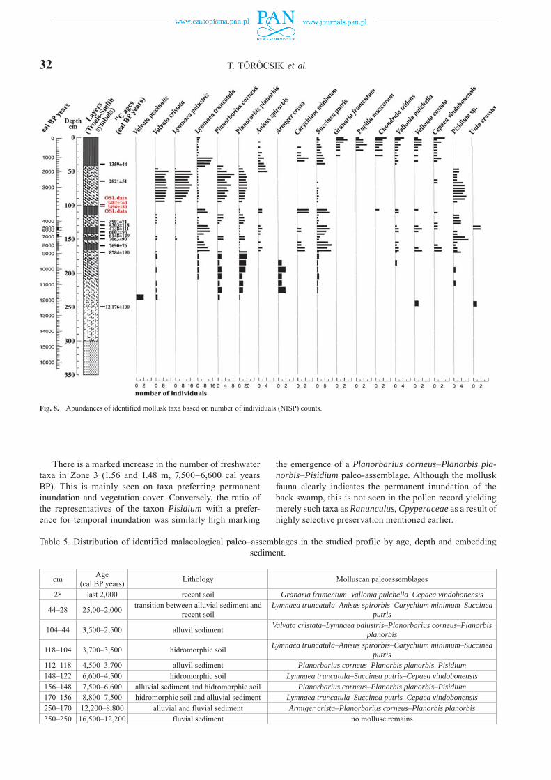
32 T. TÖRŐCSIK et al.
There is a marked increase in the number of freshwater taxa in Zone 3 (1.56 and 1.48 m, 7,500–6,600 cal years BP). This is mainly seen on taxa preferring permanent inundation and vegetation cover. Conversely, the ratio of the representatives of the taxon Pisidium with a prefer-ence for temporal inundation was similarly high marking
the emergence of a Planorbarius corneus–Planorbis pla-norbis–Pisidium paleo-assemblage. Although the mollusk fauna clearly indicates the permanent inundation of the back swamp, this is not seen in the pollen record yielding merely such taxa as Ranunculus, Cpyperaceae as a result of highly selective preservation mentioned earlier.
Table 5. Distribution of identified malacological paleo–assemblages in the studied profile by age, depth and embedding sediment.
cm Age(cal BP years) Lithology Molluscan paleoassemblages
28 last 2,000 recent soil Granaria frumentum–Vallonia pulchella–Cepaea vindobonensis
44–28 25,00–2,000 transition between alluvial sediment and recent soil
Lymnaea truncatula–Anisus spirorbis–Carychium minimum–Succinea putris
104–44 3,500–2,500 alluvil sediment Valvata cristata–Lymnaea palustris–Planorbarius corneus–Planorbis planorbis
118–104 3,700–3,500 hidromorphic soil Lymnaea truncatula–Anisus spirorbis–Carychium minimum–Succinea putris
112–118 4,500–3,700 alluvil sediment Planorbarius corneus–Planorbis planorbis–Pisidium148–122 6,600–4,500 hidromorphic soil Lymnaea truncatula–Succinea putris–Cepaea vindobonensis156–148 7,500–6,600 alluvial sediment and hidromorphic soil Planorbarius corneus–Planorbis planorbis–Pisidium170–156 8,800–7,500 hidromorphic soil and alluvial sediment Lymnaea truncatula–Succinea putris–Cepaea vindobonensis250–170 12,200–8,800 alluvial and fluvial sediment Armiger crista–Planorbarius corneus–Planorbis planorbis350–250 16,500–12,200 fluvial sediment no mollusc remains
Fig. 8. Abundances of identified mollusk taxa based on number of individuals (NISP) counts.

ENVIRONMENTAL HISTORY OF THE CSORNA PLAIN (WESTERN DANUBE PLAIN, HUNGARY) 33
There is a significant change in Zone 4 (1.48 and 1.22 m, 6,600–4,500 cal years BP) with a major increase in the ratio of terrestrial gastropods accompanied by a drop in freshwater taxa apart from the mussel taxon Pisidium. This zone is characterized by the recurrence of a Lymnaea truncatula–Succinea putris–Cepaea vindobonensis paleo assemblage and the development of a hydromorphic pedo-complex (Figs. 8, 9).
In Zone 5 (1.22–1.18 m and 4,500–3,700 cal years BP) there is another sudden increase in freshwater taxa mainly those preferring permanent inundation and the presence of lush aquatic vegetation. There is a recurrence of the so-called Planorbarius corneus–Planorbis planorbis–Pisi-dium paleo-assemblage with conditions like Zone 3.
There is a decrease in the numbers of freshwater taxa in the next mollusk zone (1.18–1.04 cm and 3,700–3,500 cal years BP) except for taxa tolerating temporary water cover-age like Lymnaea truncatula, Anisus spirorbis. Conversely, the number of terrestrial taxa increased. This increase is especially notable among water bank and marshland taxa like Carychium minimum, Succinea putris hallmarking the development of a new Lymnaea truncatula–Anisus spiror-bis–Carychium minimum, Succinea putris paleo-assem-
blage. The presence of numerous molds and the relatively high numbers of the gastropod taxa Anisus spirorbis hint to the emergence of alkaline conditions within the marshland, which might have triggered the partial dissolution of the shells. This horizon is also characterized by the development of a hydromorphic soil with features indicating periodic in-undation. The layers overlying the paleosol yielded no shells at all between the depths of 0.96 and 1.04 m. It was this hori-zon where most of the disintegrated molds were concentrated clearly indicating a secondary dissolution of the shells.
In Zone 7 (1.04–0.44 cm and 3,500–2,500 cal years BP), terrestrial taxa completely disappear giving way to a new paleo assemblage composed of ditch species (Valvata cri-stata, Lymnaea palustris, Planorbarius corneus, Planorbis planorbis). These again are characterized by a preference for permanent inundation and lush aquatic vegetation in their habitat. This zone also yielded the highest specimen numbers in the entire profile.
Zone 8 (0.44–0.28 m and 2,500–2,000 cal years BP) marks the complete disappearance of taxa preferring con-stant inundation and the occurrence of the so-called slum taxa like Lymnaea truncatula and Anisus spirorbis. This is accompanied by an increase in water bank and marshland
Fig. 9. Abundances of identified mollusk taxa by paleoecological groups.

34 T. TÖRŐCSIK et al.
terrestrial taxa like Carychium minimum and Succinea pu-tris. All this hallmark the expansion of the back swamp during the Late Iron Age and the development of hydro-morphic soils connected to partial desiccation.
The uppermost 0.28 m representing the period of the last 2000 years corresponds to Zone 9. Here a marked dominance of terrestrial fauna was observed with a preva-lence of drought-tolerant xerophilic taxa e.g. Granaria fru-mentum, Pupilla muscorum, Chondrula tridens, Vallonia costata, Cepaea vindobonensis. In addition, proportions of the strongly hygrophillic Succinea putris and Vallonia pulchella populating nearbank areas and wet meadows was likewise high (Figs. 8, 9). Slum and ditch species like Lymnaea truncatula, Anisus spirorbis harboring ponds and temporary mud pools also turn up in this zone. The accurate evaluation of this horizon was not without hardships due to the plow-induced disturbance and mixing of the soil. A marked slide was recorded between the depths of 0.38 and 0.42 m. The topsoil yielded some poorly preserved speci-mens of the terrestrial gastropod taxa Chondrula tridens and Vallonia pulchella. All in all, the recurring nature of mollusk paleo assemblages throughout the profile is in line with the observed cyclicity of the sediment indicating re-curring flood cycles on the floodplain. The height, length, strength of these floods, the degree of succeeding desicca-tion, the composition of the transported sediment has all had an impact in shaping the faunal composition.
RECONSTRUCTED ENVIRONMENTAL HISTORY OF THE AREA
According to the literature, the geological evolution of the Csorna Plain was controlled by one of the largest trib-utaries of the Danube, the Raab or Rába River forming an alluvial fan, which was actively developing until the Late Glacial (Pécsi, 1959, 1962; Somogyi, 1961; Gábris, 1985, 1995, 1998, 2002; Gábris and Nádor, 2007; Lovász, 2007). What’s more a recent archeological paper went as far as to consider the entire plain an integral part of this alluvial fan system (Mester et al., 2014, 2015).
Our findings are at total odds with these theoretical assumptions. Based on our results, the Csorna Plain hosted a system of Late Glacial small fluvial channels running parallelly with a SE-NW trend (Figs. 1, 10). Conversely, the channel of the larger Rába River has utterly differing orien-tation and size, which cannot explain the mentioned geolog-ical and geomorphological structure of the fluvial network of the Csorna Plain (Sümegi et al., 2012). The geological features identified at the excavation site of Csorna–Lórét revealed a complex fluvial system of a Late Glacial creek with its complete sub facies ranging from channel deposits, a clay plug, a point bar, levee series with an alternation of slack water fines and floodwater sands (Fig. 2) (Ghinassi et al., 2016). According to 14C dates, the channel deposits accumulated during the Late Glacial preceding 12,200 cal years BP. The trajectory of the creek is perpendicular to the Rába riverbed. Detailed analysis of historical maps and
digital elevation models created using aerial photographs and cartographic data revealed the presence of parallel creek beds starting out from the area of the Transdanubian Hills found to the SE (Fig. 10) forming an alluvial fan inde-pendently from that of the Holocene Rába River during the Late Glacial (18–22 kyrs).
The development of this independent alluvial fan com-plex is attributable to the different position and subsid-ence rates of neotectonic basins during this time from their modern counterparts as seen on maps recording the thick-ness of Quaternary fluvial deposits (Sümeghy, 1944; Jaskó, 1935). During this time, the fluvial network was made up of parallelly running creeks with a NW-SE trend including the creek observed at our site and the Rába River itself too. Neotectonic activities were displaced following the LGM leading to the emergence of new sub basins pro-viding new accommodation areas for fluvial deposits. As a result, the course of the Rába River was also displaced into its modern position running into the NE (Fig. 10). This major shift beheaded the former parallelly running system of creeks turning them into inactive drainage channels un-
Fig. 10. The system of parallel-running creeks with a NW-SE trend observed on the digital elevation model of the wider surroundings of the Csorna Plain. Note the perpendicular trajectory of the modern Rába River to the section A-B-C.
ENVIRONMENTAL HISTORY OF THE CSORNA PLAIN (WESTERN DANUBE PLAIN, HUNGARY) 35
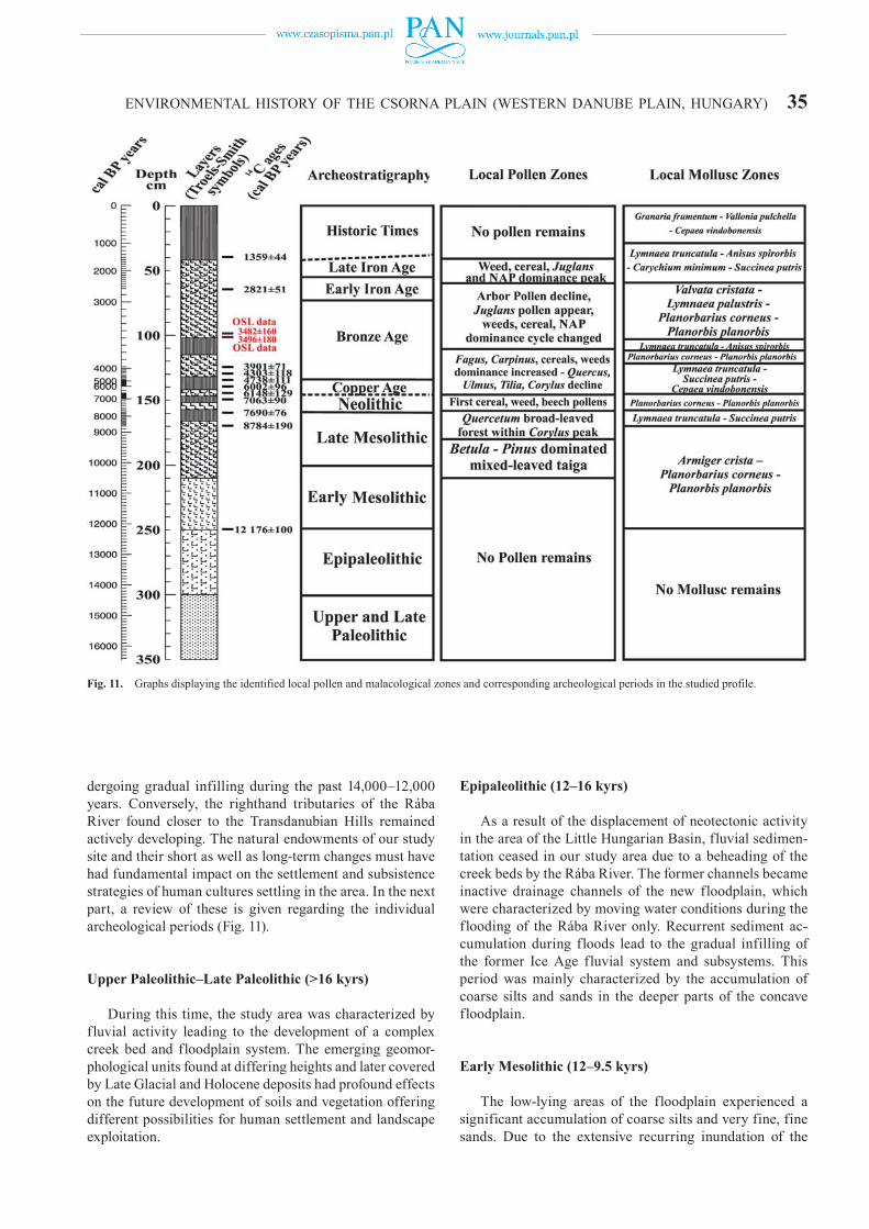
dergoing gradual infilling during the past 14,000–12,000 years. Conversely, the righthand tributaries of the Rába River found closer to the Transdanubian Hills remained actively developing. The natural endowments of our study site and their short as well as long-term changes must have had fundamental impact on the settlement and subsistence strategies of human cultures settling in the area. In the next part, a review of these is given regarding the individual archeological periods (Fig. 11).
Upper Paleolithic–Late Paleolithic (>16 kyrs)
During this time, the study area was characterized by fluvial activity leading to the development of a complex creek bed and floodplain system. The emerging geomor-phological units found at differing heights and later covered by Late Glacial and Holocene deposits had profound effects on the future development of soils and vegetation offering different possibilities for human settlement and landscape exploitation.
Epipaleolithic (12–16 kyrs)
As a result of the displacement of neotectonic activity in the area of the Little Hungarian Basin, fluvial sedimen-tation ceased in our study area due to a beheading of the creek beds by the Rába River. The former channels became inactive drainage channels of the new floodplain, which were characterized by moving water conditions during the flooding of the Rába River only. Recurrent sediment ac-cumulation during floods lead to the gradual infilling of the former Ice Age fluvial system and subsystems. This period was mainly characterized by the accumulation of coarse silts and sands in the deeper parts of the concave floodplain.
Early Mesolithic (12–9.5 kyrs)
The low-lying areas of the floodplain experienced a significant accumulation of coarse silts and very fine, fine sands. Due to the extensive recurring inundation of the
Fig. 11. Graphs displaying the identified local pollen and malacological zones and corresponding archeological periods in the studied profile.

36 T. TÖRŐCSIK et al.
floodplain freshwater mollusks inhabiting moving wa-ter habitats also turned up. The adjacent terrestrial areas hosted a mixed taiga woodland having a vegetation similar to the Pre-Alpine and Sub-Carpathian regions (Willis et al., 1997, 1998; Sümegi, 1999; Juhász, 2007a–c; Magyari et al., 2009; Sümegi and Törőcsik, 2007; Törőcsik et al., 2014, 2015; Sümegi and Náfrádi, 2015; Sümegi et al., 2012). The composition of the vegetation was in line with the one pre-sumed for the so-called Birch-Pine phase of the Holocene (Zólyomi, 1952).
Late Mesolithic (9.5–7.6 kyrs)
This period hallmarks the initiation of cyclical sediment accumulation of carbonate rich silts and organic rich clays on the floodplain and the development of hydromorphic soils. During the Late Mesolithic mixed taiga woodlands were exchanged for hardwood and softwood deciduous woodlands. The former was clearly prevailed by oak com-plemented by other hardwood elements of ash and elm in addition to scattered stands of hazelnut. Softwood gallery forests were made up of stands of willow and alder. The first appearance and general homogenization of deciduous woodlands and the expansion of oak happened during this period in other parts of the Carpathian Basin too (Willis et al., 1997, 1998; Sümegi, 1999; Juhász, 2007a–c; Magyari et al., 2009; Sümegi and Törőcsik, 2007; Törőcsik et al., 2014, 2015; Sümegi and Náfrádi, 2015; Sümegi et al., 2012).
Neolithic (7.6/7.5–6.5 kyrs)
This period is characterized by the development of two silt-rich horizons connected to flooding during times of higher rainfall with two intercalating clayey marshland de-posits and hydromorphic soils marking drier climatic condi-tions. Hydromorphic soils yielded hygrophilous water bank and marshland terrestrial gastropods. On the other hand, floodplain deposits are characterized by clear dominance freshwater taxa with a preference for constant water cov-erage. The opening of the Neolithic also hallmarked the appearance of beech and alder as well as cereals and weeds. Their increasing ratio clearly indicate rising human pressure on the environment connected to agricultural activities. The records of Middle Neolithic architecture clearly refer to the development of a local settlement in our study area.
Copper Age (6.5–2.5 kyrs)
Influences of human activities on the landscape re-mained significant. This period is characterized by the development of horizon containing slash water fines and hallmarking a climate with higher rainfall. A horizon of hydromorphic soils however indicates the presence of an-other drier climatic phase during the Copper Age in addi-tion to the former wet phase. These are clearly reflected in
the composition of the mollusk fauna as well. The pollen composition of the Copper Age remained the same as the Late Neolithic.
Bronze Age (2.5–0.9 kyrs)
Numerous alternating floodplain and hydromorphic soil horizons record the cyclical succession of wet and dry climatic periods during the Bronze Age. The Early Bronze Age must have had a wetter climate as seen from our sedi-ment and malacological records. Drier conditions emerged during the terminal part of the Bronze Age and were sus-tained during the Middle Bronze Age. The terminal part of the Middle Bronze Age records the climate with the highest rainfall. This continued onto the Early Iron Age as well. Based on the observed pollen composition and the found Early Bronze Age archeology indicating the development of another settlement in our study are marks major changes in the vegetation. There is a major decline in the ratio of arboreal elements with the reappearance of cereals and new type of weeds. In addition, the first records of walnut pollen grains are also connected to this period.
Early Iron Age (0.9 and 0.6 kyrs)
The former wet climatic phase persisted during the en-tire Iron Age as seen in the prevalence of a mollusk fauna with a preference for constant water cover in addition to the clayey silts of floodplain deposits. There is no major change in the pollen composition compared to the Bronze Age indicating the continuation of similar human activities in the area. The appearance of the archeology of the Hallstatt Culture marking another settlement in the area is in line with the inferred vegetation composition and landscape reconstruction.
Late Iron Age (0.6 kyrs–0 AD)
This period marks the initiation of pedogenesis on floodplain deposits of the Bronze Age and Early Iron Age leading to the development of the modern topsoil. The com-position of the mollusk fauna indicates a gradual desicca-tion. The pollen composition was not suitable for evaluation due to mixing and erosion connected to drainage activities and plowing.
Last 2000 years
The last 2000 years represent the development of the modern soil. The presence of water bank and marshland mollusk taxa in addition to drought tolerating elements in-dicate the presence of a highly complex environment com-posed of mosaics. The original soil must have been a hy-dromorphic luvisol which was turned into a hydromorphic
ENVIRONMENTAL HISTORY OF THE CSORNA PLAIN (WESTERN DANUBE PLAIN, HUNGARY) 37
chernozem as a result of fertilization, plowing and other agricultural activities. This soil horizon yielded numerous artifacts dated to the Migration Age and the Early Middle Ages. However, due to the highly disturbed nature of the soil no reliable information could have been recovered in connection with the paleoenvironmental conditions.
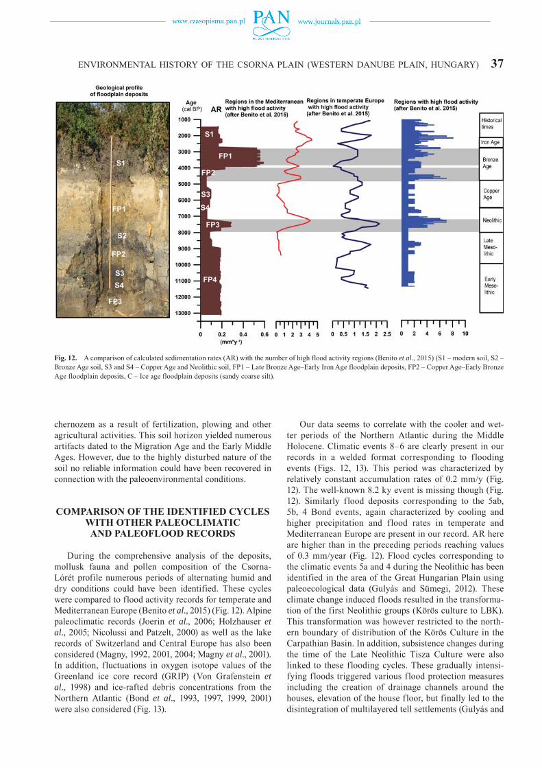
COMPARISON OF THE IDENTIFIED CYCLES WITH OTHER PALEOCLIMATIC AND PALEOFLOOD RECORDS
During the comprehensive analysis of the deposits, mollusk fauna and pollen composition of the Csorna-Lórét profile numerous periods of alternating humid and dry conditions could have been identified. These cycles were compared to flood activity records for temperate and Mediterranean Europe (Benito et al., 2015) (Fig. 12). Alpine paleoclimatic records (Joerin et al., 2006; Holzhauser et al., 2005; Nicolussi and Patzelt, 2000) as well as the lake records of Switzerland and Central Europe has also been considered (Magny, 1992, 2001, 2004; Magny et al., 2001). In addition, fluctuations in oxygen isotope values of the Greenland ice core record (GRIP) (Von Grafenstein et al., 1998) and ice-rafted debris concentrations from the Northern Atlantic (Bond et al., 1993, 1997, 1999, 2001) were also considered (Fig. 13).
Our data seems to correlate with the cooler and wet-ter periods of the Northern Atlantic during the Middle Holocene. Climatic events 8–6 are clearly present in our records in a welded format corresponding to flooding events (Figs. 12, 13). This period was characterized by relatively constant accumulation rates of 0.2 mm/y (Fig. 12). The well-known 8.2 ky event is missing though (Fig. 12). Similarly flood deposits corresponding to the 5ab, 5b, 4 Bond events, again characterized by cooling and higher precipitation and flood rates in temperate and Mediterranean Europe are present in our record. AR here are higher than in the preceding periods reaching values of 0.3 mm/year (Fig. 12). Flood cycles corresponding to the climatic events 5a and 4 during the Neolithic has been identified in the area of the Great Hungarian Plain using paleoecological data (Gulyás and Sümegi, 2012). These climate change induced floods resulted in the transforma-tion of the first Neolithic groups (Körös culture to LBK). This transformation was however restricted to the north-ern boundary of distribution of the Körös Culture in the Carpathian Basin. In addition, subsistence changes during the time of the Late Neolithic Tisza Culture were also linked to these flooding cycles. These gradually intensi-fying floods triggered various flood protection measures including the creation of drainage channels around the houses, elevation of the house floor, but finally led to the disintegration of multilayered tell settlements (Gulyás and
Fig. 12. A comparison of calculated sedimentation rates (AR) with the number of high flood activity regions (Benito et al., 2015) (S1 – modern soil, S2 – Bronze Age soil, S3 and S4 – Copper Age and Neolithic soil, FP1 – Late Bronze Age–Early Iron Age floodplain deposits, FP2 – Copper Age–Early Bronze Age floodplain deposits, C – Ice age floodplain deposits (sandy coarse silt).

38 T. TÖRŐCSIK et al.
Sümegi, 2011a, b, 2012). Bond events 3 and 2 also turn up welded in our records (Figs. 12, 13). These events mark the most intensive flooding in our area during the periods of the Late Bronze Age, Early Iron Age (Fig. 12). AR are threefold of that of the Early Neolithic (Fig. 12). These records of intensive floods are in line with high-stands recorded for Swiss lakes (Magny et al., 2003) and other flood events around Europe (Benito et al., 2015). Flooding however affected only the lower lying areas of the flood-plain leaving the natural levees flood free. As these are 1.7–2 m above the floodplain floods and accompanying rises in the groundwater table must have been below this value in general. However, the presence of drainage chan-nels around the settlements during the Late Bronze Age, Early Iron Age and Early Middle Ages corresponding to the most humid periods with the highest floods recorded might indicate that floods could have reached a height beyond 2 m during these intervals. Synchrony of these with European flood records (Benito et al., 2015) is also striking (Fig. 12). It must be noted though that an explosion in the population required the extension of agricultural activities to the lower parts of the floodplain too.
Acknowledgements
The research was supported by OTKA grant K-112318 (An Environmental History of the Carpathian Basin in the Middle Ages), the Principal Leader is Prof. Elek Benkő, academic director (Institute of Archaeology, Hungarian Academy of Sciences, Budapest). Research has been carried out within the framework of University of Szeged, Interdisciplinary Excellence Centre, Institute of Geography and Earth Sciences, Long Environmental Changes Research Team. Support of the Ministry of Human Capacities, Hungary grant 20391-3/2018/FEKUSTRAT is acknowledged.
REFERENCES
Alexandrowicz, W.P., 2004. Molluscan assemblages of Late Glacial and Holocene calcareous tufa in Southern Poland. Folia Quater-naria 75, 3–309.
Alexandrowicz, W.P., Dmytruk, R., 2010. Molluscs in Eemian–Vis-tulian deposits of the Kolodiiv section, Ukraine (East Carpathian Foreland) and their palaeoecological interpretation. Geological Quarterly 51, 173–178.
An, Z., Kukla, G.J., Porter, S.C., Xiao, J., 1991. Magnetic suscepti-bility evidence of monsoon variation on the Loess Plateau of cen-
Fig. 13. A comparison identified flood cycles with paleoclimatic records of Europe and the North Atlantic (Alpine paleoclimatic records after Joerin et al., 2006; Holzhauser et al., 2005; Nicolussi and Patzelt 2000, lake records of Switzerland and Central Europe after Magny, 1992, 2001, 2004; Magny et al., 2001. Greenland ice core record (GRIP) after Von Grafenstein et al., 1998. and ice-rafted debris concentrations from the Northern Atlantic after Bond et al., 1993, 1997, 1999, 2001).
ENVIRONMENTAL HISTORY OF THE CSORNA PLAIN (WESTERN DANUBE PLAIN, HUNGARY) 39tral China during the last 130,000 years. Quaternary Research 36, 29–36.
Antoine, P., Rousseau, D.D., Zöller, L., Lang, A., Munaut, A.V., Hatté, C., Fontugne, M., 2001. High-resolution record of the last intergla-cial-glacial cycle in the Nussloch loess-palaeosol sequences, Up-per Rhine Area, Germany. Quaternary International 76, 211–229.
Barham, A.J., 1995. Methodological approaches to archaeological context recording: X-radiography as an example of a supportive recording, assessment and interpretative technique. In: Barham, A. J., Macphail, R.I. (Eds), Archaeological sediments and soils: Analysis, interpretation and management. Archetype Books, Insti-tute of Archaeology, London. 145–182.
Barham, A.J., Macphail, R.I., 2016. Archaeological sediments and soils: analysis, interpretation and management. Routledge Press, London.
Bates, M.R., Bates, C.R., 2000. Multidisciplinary approaches to the geoarchaeological evaluation of deeply stratified sedimentary sequences: examples from Pleistocene and Holocene deposits in southern England, United Kingdom. Journal of Archaeological Science 27, 845–858.
Bánffy, E., 2000. The late Starčevo and the earliest Linear Pottery groups in western Transdanubia. Documenta Praehistorica 27, 173–185.
Bánffy, E., 2006. Eastern, Central and Western Hungary – variations of Neolithisation models. Documenta Praehistorica 33, 125–142.
Bendefy, L., 1977. Hungarian Little Plain and Prealpin region. Földra-jzi Értesítő 26, 486–489. (in Hungarian)
Benito, G., Macklin, M.G., Panin, A., Rossato, S., Fontana, A., Jones, A.F., Machado, M.J., Matlakhova, E., Mozzi, P., Zielhofer, C., 2015, Recurring flood distribution patterns related to short-term Holocene climatic variability, Nature, Scientific Reports 5(16398), 1–8.
Bennett, K.D., 1992. PSIMPOLL – A quickBasic program that gen-erates PostScript page description of pollen diagrams. INQUA Commission for the study of the Holocene: working group on data handling methods, Newsletter 8, 11–12.
Bennett, K.D., Willis, K.J., 2001. Pollen. In: Smol, J.P., Birks, H.J.B., Last, W.M. (Eds), Tracking environmental change using lake sedi-ments. Volume 3: terrestrial, algal, and siliceous indicators. Kluw-er Academic Publishers, Dordrecht, 5–32.
Blaauw, M., Christen, J.A., 2011. Flexible paleoclimate ageedepth models using an autoregressive gamma process. Bayesian Anal-ysis 3, 457–474.
Bond, G., Broecker, W., Johansen, S., Labeyrie, L., McManus, J., Jou-zel, J., Bonani, G., 1993. Correlation between climate records from North Atlantic sediments and Greenland ice. Nature 365, 245–249.
Bond, G., Showers, W., Cheseby, M., Lotti, R., Almasi, P., Priore, P., de Menocal, P., Priore, P., Cullen, H., Hajdas, I., Bonani, G., 1997. A pervasive millennial-scale cycle in North Atlantic Holocene and glacial climates. Science 278, 1257–1266.
Bond, G.C., Showers, W., Elliot, M., Evans, M., Lotti, R., Hajdas, I., Bonani, G., Johnson, S., 1999. The North Atlantic’s 1–2 Kyr Cli-mate Rhythm: Relation to Heinrich Events, Dansgaard /Oeschger Cycles and the Little Ice Age. In: Clark, P.U., Robert S.W., Lloyd, D.K. (Eds), Mechanisms of global climate change at millennial time scales. Geophysical Monographs 112, American Geophysical Union, Washington, USA, 35–58.
Bond, G., Kromer, B., Beer, J., Muscheler, R., Evans, M.N., Showers, W., Hoffmann, S., Lotti-Bond, R., Hajdas, I., Bonani, G., 2001. Persistent solar influence on North Atlantic climate during the Ho-locene. Science 294, 2130–2136.
Bronk-Ramsey, C., 2009. Bayesian analysis of radiocarbon dates. Ra-diocarbon 51, 337–360.
Bradshaw, R.H.W., Webb III, T., 1985. Relationships between contem-porary pollen and vegetation data from Wisconsin and Michigan, USA. Ecology 66, 721–737.
Burga, C.A., 1988. Swiss vegetation history during the last 18,000 years. New Phytologist 110, 581–662.
Crowther, J., 2003. Potential magnetic susceptibility and fractional conversion studies of archaeological soils and sediments. Archae-ometry 45, 685–701.
Cruden, R.W., Hermann, S.M, Peterson, S., 1983. Patterns of nectar production and plant-pollinator coevolution. In: Bentley, B., Elias, T. (Eds), The biology of nectaries, 80–125. Columbia University Press, New York, New York, USA.
Dániel, P., 2004. Methods of the five-step extraction-digestion method. Results of the five-step extraction-digestion method. In: Sümegi, P., Gulyás, S. (Eds), The geohistory of Bátorliget Marshland. Ar-chaeolingua Press, Budapest, 53–56 and 98–108.
Dean Jr, W.E., 1974. Determination of carbonate and organic matter in calcareous sediments and sedimentary rocks by loss on ignition: comparison with other methods. Journal of Sedimentary Research 44, 242–248.
Dearing, J., 1994. Environmental magnetic susceptibility. Using the Bartington MS2 system. Chi Publ., Kenilworth.
Dowdeswell, J.A., 1982. Relative dating of late Quaternary deposits using cluster and discriminant analysis, Audubon Cirque, Mt. Audubon, Colorado Front Range. Boreas 11, 151–161.
Egry, I., 2009. A new site of the Transdanubian Linear Pottery culture in the Little Hungarian Plane. In: Bende, L., Lőriczy G. (Eds), From Medina to Ete. Móra Ferenc Múzeum kiadványa, Szentes.
Evans, J.G., 1972. Land Snails in Archeology. Seminar Press, London.Ferenczi, I., 1924. Geomophological studies on the southern basin of
the Little Hungarian Plain. Földtani Közlöny 54, 17–38. (in Hun-garian)
Fall, P.L., 1987. Pollen taphonomy in a canyon stream. Quaternary Research 28, 393–406.
Fodor, L., Bada, G., Csillag, G., Horváth, E., Ruszkiczai-Rüdiger, Z., Palotás, K., Síkhegyi, F., Timár, G., Cloetingh, S., Horváth, F., 2005. An outline of neotectonic structures and morphotectonics of the western and central Pannonian Basin. Tectonophysics 410, 15–41.
Gábris, G., 1985. The sketch of the paleohydrology of the Great Hun-garian Plain. Földrajzi Értesítő,34, 391–408. (in Hungarian)
Gábris, G., 1995. The new results of the paleohidrological researhes. Földrajzi Értesítő 44, 101–109.
Gábris, G., 1998. Late Glacial and Post Glacial development of drain-age network and the paleohydrology in the Great Hungarian Plain. In: Bassa, L.Kertész, Á. (Eds), Windows on Hungarian Geogra-phy. Akadémiai Kiadó, Budapest, 23–36.
Gábris, G., 2002. The shifting Tisza River. In: Mészáros, E., Sch-weitzer, F. Tóth, J. eds. László Jakucs, the scholar, the educator and the artist. A MTA Földrajztudományi Kutatóintézet és a Pécsi Tudományegyetem kiadása, Pécs, 91–105.
Gábris, G., Nádor, A., 2007. Long-term fluvial archives in Hungary: response of the Danube and Tisza rivers to tectonic movements and climatic changes during the Quaternary: a review. Quaternary Science Reviews 26, 2758–2782.
Ghinassi, M., Ielpi, A., Aldinucci, M., Fustic, M., 2016. Down-stream-migrating fluvial point bars in the rock record. Sedimen-tary Geology 334, 66–96.
Gulyás, S, Sümegi, P., 2011a. Farming or foraging? New environmen-tal data to the life and economic transformation of Late Neolithic tell communities (Tisza Culture) in SE Hungary. Journal of Ar-chaeological Science 38, 3323–3339
Gulyás, S, Sümegi, P., 2011b. Riparian environment in shaping social and economic behavior during the first phase of the evolution of Late Neolithic tell complexes in SE Hungary. Journal of Archaeo-logical Science 38, 2683–2695.
Gulyás, S, Sümegi, P., 2012. Édesvízi puhatestűek a környezetrégészet-ben. Geolitera Kiadó, Szeged, 165 p.
Hall, S.A., 1989. Pollen analysis and paleoecology of alluvium. Qua-ternary Research 31, 435–438.
Hargitai, A., 2013. Summary report. Szilsárkány, Miklós-tag. M 85–M
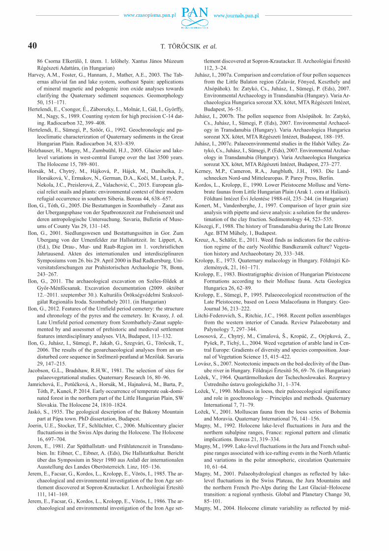
40 T. TÖRŐCSIK et al.
86 Csorna Elkerülő, I. ütem. 1. lelőhely. Xantus János Múzeum Régészeti Adattára, (in Hungarian)
Harvey, A.M., Foster, G., Hannam, J., Mather, A.E., 2003. The Tab-ernas alluvial fan and lake system, southeast Spain: applications of mineral magnetic and pedogenic iron oxide analyses towards clarifying the Quaternary sediment sequences. Geomorphology 50, 151–171.
Hertelendi, E., Csongor, É., Záborszky, L., Molnár, I., Gál, I., Győrffy, M., Nagy, S., 1989. Counting system for high precision C-14 dat-ing. Radiocarbon 32, 399–408.
Hertelendi, E., Sümegi, P., Szöőr, G., 1992. Geochronologic and pa-leoclimatic characterization of Quaternary sediments in the Great Hungarian Plain. Radiocarbon 34, 833–839.
Holzhauser, H., Magny, M., Zumbuühl, H.J., 2005. Glacier and lake- level variations in west-central Europe over the last 3500 years. The Holocene 15, 789–801.
Horsák, M., Chytrý, M., Hájková, P., Hájek, M., Danihelka, J., Horsáková, V., Ermakov, N., German, D.A., Kočí, M., Lustyk, P., Nekola, J.C., Preislerová, Z., Valachoviċ, C., 2015. European gla-cial relict snails and plants: environmental context of their modern refugial occurrence in southern Siberia. Boreas 44, 638–657.
Ilon, G., Tóth, G., 2005. Die Bestattungen in Szombathely – Zanat aus der Ubergangsphase von der Spatbronzezeit zur Fruheisenzeit und deren antropologische Untersuchung. Savaria, Bulletin of Muse-ums of County Vas 29, 131–145.
Ilon, G., 2001. Siedlungswesen und Bestattungssitten in Gor. Zum Ubergang von der Urnenfelder zur Hallstattzeit. In: Lippert, A. (Ed.), Die Drau-, Mur- und Raab-Region im 1. vorchristlichen Jahrtausend. Akten des internationalen und interdisziplinaren Symposiums vom 26. bis 29. April 2000 in Bad Radkersburg. Uni-versitatsforschungen zur Prahistorischen Archaologie 78, Bonn, 243–267.
Ilon, G., 2011. The archaeological excavation on Széles-földek at Győr-Ménfőcsanak. Excavation documentation (2009. október 12.–2011. szeptember 30.). Kulturális Örökségvédelmi Szakszol-gálat Regionális Iroda. Szombathely 2011. (in Hungarian)
Ilon, G., 2012. Features of the Urnfield period cemetery: the structure and chronology of the pyres and the cemetery. In: Kvassy, J. ed. Late Urnfield period cementery from Szombathely-Zanat supple-mented by and assessmet of prehistoric and medieval settlement features interdisciplinary analyses. VIA, Budapest, 113–132.
Ilon, G., Juhász, I., Sümegi, P., Jakab, G., Szegvári, G., Törőcsik, T., 2006. The results of the geoarchaeological analyses from an un-disturbed core sequence in Szélmező peatland at Mezőlak. Savaria 29, 147–215.
Jacobson, G.L., Bradshaw, R.H.W., 1981. The selection of sites for palaeovegetational studies. Quaternary Research 16, 80–96.
Jamrichová, E., Potůčková, A., Horsák, M., Hajnalová, M., Barta, P., Tóth, P., Kuneš, P. 2014. Early occurrence of temperate oak-domi-nated forest in the northern part of the Little Hungarian Plain, SW Slovakia. The Holocene 24, 1810–1824.
Jaskó, S., 1935. The geological description of the Bakony Mountain part at Pápa town. PhD dissertation, Budapest.
Joerin, U.E., Stocker, T.F., Schlüchter, C., 2006. Multicentury glacier fluctuations in the Swiss Alps during the Holocene. The Holocene 16, 697–704.
Jerem, E., 1981. Zur Späthallstatt- und Frühlatenezeit in Transdanu-bien. In: Eibner, C., Eibner, A. (Eds), Die Hallstattkultur. Bericht über das Symposium in Steyr 1980 aus Anlaß der internationalen Ausstellung des Landes Oberösterreich. Linz, 105–136.
Jerem, E., Facsar, G., Kordos, L., Krolopp, E., Vörös, I., 1985. The ar-chaeological and environmental investigation of the Iron Age set-tlement discovered at Sopron-Krautacker. I. Archeológiai Értesítő 111, 141–169.
Jerem, E., Facsar, G., Kordos, L., Krolopp, E., Vörös, I., 1986. The ar-chaeological and environmental investigation of the Iron Age set-
tlement discovered at Sopron-Krautacker. II. Archeológiai Értesítő 112, 3–24.
Juhász, I., 2007a. Comparison and correlation of four pollen sequences from the Little Balaton region (Zalavár, Fönyed, Keszthely and Alsópáhok). In: Zatykó, Cs., Juhász, I., Sümegi, P. (Eds), 2007. Environmental Archaeology in Transdanubia (Hungary). Varia Ar-chaeologica Hungarica sorozat XX. kötet, MTA Régészeti Intézet, Budapest, 36–51.
Juhász, I., 2007b. The pollen sequence from Alsópáhok. In: Zatykó, Cs., Juhász, I., Sümegi, P. (Eds), 2007. Environmental Archaeol-ogy in Transdanubia (Hungary). Varia Archaeologica Hungarica sorozat XX. kötet, MTA Régészeti Intézet, Budapest, 188–195.
Juhász, I., 2007c. Palaeoenvironmental studies in the Hahót Valley. Za-tykó, Cs., Juhász, I., Sümegi, P. (Eds), 2007. Environmental Archae-ology in Transdanubia (Hungary). Varia Archaeologica Hungarica sorozat XX. kötet, MTA Régészeti Intézet, Budapest, 273–277.
Kerney, M.P., Cameron, R.A., Jungbluth, J.H., 1983. Die Land-schnecken Nord-und Mitteleuropas. P. Parey Press, Berlin.
Kordos, L., Krolopp, E., 1990. Lower Pleistocene Mollusc and Verte-brate faunas from Little Hungarian Plain (Arak 1. cora at Halászi). Földtani Intézet Évi Jelentése 1988-ról, 235–244. (in Hungarian)
Konert, M., Vandenberghe, J., 1997. Comparison of layer grain size analysis with pipette and sieve analysis: a solution for the underes-timation of the clay fraction. Sedimentology 44, 523–535.
Kőszegi, F., 1988. The history of Transdanubia during the Late Bronze Age. BTM Műhely, 1, Budapest.
Kreuz, A., Schäfer, E., 2011. Weed finds as indicators for the cultiva-tion regime of the early Neolithic Bandkeramik culture? Vegeta-tion history and Archaeobotany 20, 333–348.
Krolopp, E., 1973. Quaternary malacology in Hungary. Földrajzi Kö-zlemények, 21, 161–171.
Krolopp, E., 1983. Biostratigraphic division of Hungarian Pleistocene Formations according to their Mollusc fauna. Acta Geologica Hungarica 26, 62–89.
Krolopp, E., Sümegi, P., 1995. Palaeoecological reconstruction of the Late Pleistocene, based on Loess Malacofauna in Hungary. Geo-Journal 36, 213–222.
Litchi-Federovich, S., Ritchie, J.C., 1968. Recent pollen assemblages from the western interior of Canada. Review Palaeobotany and Palynology 7, 297–344.
Lososová, Z., Chytrý, M., Cimalová, Š., Kropáč, Z., Otýpková, Z., Pyšek, P., Tichý, L., 2004. Weed vegetation of arable land in Cen-tral Europe: Gradients of diversity and species composition. Jour-nal of Vegetation Science 15, 415–422.
Lovász, S., 2007. Neotectonic impacts on the bed-declivity of the Dan-ube river in Hungary. Földrajzi Értesítő 56, 69–76. (in Hungarian)
Ložek, V., 1964. Quartärmollusken der Tschechoslowakei. Rozpravy Ústredniho ústavu geologického 31, 1–374.
Ložek, V., 1990. Molluscs in loess, their paleoecological significance and role in geochronology – Principles and methods. Quaternary International 7, 71–79.
Ložek, V., 2001. Molluscan fauna from the loess series of Bohemia and Moravia. Quaternary International 76, 141–156.
Magny, M., 1992. Holocene lake-level fluctuations in Jura and the northern subalpine ranges, France: regional pattern and climatic implications. Boreas 21, 319–334.
Magny, M., 1999. Lake-level fluctuations in the Jura and French subal-pine ranges associated with ice-rafting events in the North Atlantic and variations in the polar atmospheric, circulation Quaternaire 10, 61–64.
Magny, M., 2001. Palaeohydrological changes as reflected by lake- level fluctuations in the Swiss Plateau, the Jura Mountains and the northern French Pre-Alps during the Last Glacial–Holocene transition: a regional synthesis. Global and Planetary Change 30, 85–101.
Magny, M., 2004. Holocene climate variability as reflected by mid-

ENVIRONMENTAL HISTORY OF THE CSORNA PLAIN (WESTERN DANUBE PLAIN, HUNGARY) 41European lake-level fluctuations and its probable impact on pre-historic human settlements. Quaternary International 113, 65–79.
Magny, M., Guiot, J., Schoellammer, P., 2001. Quantitative recon-struction of Younger Dryas to mid-Holocene paleoclimates at Le Locle, Swiss Jura, using pollen and lake-level data. Quaternary Research 56, 170–180.
Magny, M., Bégeot, C., Guiot, J., Peyron, O., 2003. Contrasting pat-terns of hydrological changes in Europe in response to Holocene climate cooling phases. Quaternary Science Reviews 22, 1589–1596.
Magyari, E.K., 2002. Climatic versus human modification of the Late Quaternary vegetation in Eastern Hungary. PhD Thesis, Debrecen.
Magyari, E.K., 2011. Late Quaternary vegetation history in the Hor-tobágy steppe and Middle Tisza floodplain, NE Hungary. Studia Botanica Hungarica 42, 185–203. (in Hungarian)
Magyari, E., Jakab, G., Rudner, E., Sümegi, P., 1999. Palynological and plant macrofossil data on Late Pleistocene short term climatic osscilations in North-east Hungary. Acta Palaeobotanica, Supple-ment, 491–502.
Magyari, E., Jakab, G., Sümegi, P., Rudner, E., Molnár, M., 2000. Pa-leobotanical analyses on the Mohos lakes at Kelemér (Hungary). In: Szurdoki, E. (Ed.), Sphagnum peat-bog biotops in Hungary: re-search, treatment and protect. CEEWEB Munkacsoport, Miskolc, 101–131. (in Hungarian)
Magyari,, E., Sümegi, P., Braun, M., Jakab, G., 2001. Retarded hy-drosere: anthropogenic and climatic signals in a Holocene raised bog profile from the NE Carpathian Basin. Journal of Ecology 89, 1019–1032.
Magyari, E.K., Jakab, G., Sümegi, P., 2009. Holocene vegetation dy-namics in the Bereg Plain, NE Hungary – the Báb-tava pollen and plant macrofossil record. Acta Geographica at Geologica et Mete-orologica Debrecina 42, 39–56.
Magyari, E.K., Chapman, J.C., Passmore, D.G., Allen, J.R.M., Huntley, J.P., Huntley, B., 2010a. Holocene persistence of wooded steppe in the Great Hungarian Plain. Journal of Biogeography 37, 915–935.
Magyari, E., Shiel, R., Passmore, D., 2010b. Introduction: The paleo- environment and settlement context of Polgár-10. In: Chapman, J., Gillings, M., Shiel, R., Gaydarska, B., Bond, C., Passmore, D., Félegyházi, E., Lumley, I., Jones, R., Edwards, J., Hardy, K., Tel-ford, D., Brighton, D., Dobney, K., Gyulai, F., Rudner, E., Rega, B., Brown, K., Higham, T. (Eds), The Upper Tisza Project, Studies in Hungarian Landscape Archaeology, Book 4: Lowland Settle-ment in North East Hungary: Excavations at the Neolithic Settle-ment Site Polgár-10. Archaeopress, Oxford.
Magyari, E.K., Chapman, J., Fairbairn, A.S., Francis, M., de Guzman, M., 2012. Neolithic human impact on the landscapes of North-East Hungary inferred from pollen and settlement records. Vegeta-tion History and Archaeobotany 21, 279–302.
Magyari, E.K., Kuneš, P., Jakab, G., Sümegi, P., Pelánková, B., Schäb-itz, F., Braun, M., Chytrý, M., 2014. Last glacial maximum vege-tation in East Central Europe: are there true analogues in Siberia? Quaternary Science Reviews 95, 60–79.
Mester, Zs., Faragó, N., Király, A., 2014. The first in situ Old Stone Age assemblage from the Rába Valley, Northwestern Hungary. Dissertationes Archaeologicae 3, 351–362.
Mester, Zs., Faragó, N., Halbrucker, É., Király, A., Péntek, A., 2015. Páli-dombok: The first authentic site from the Old Stone Age in the Rába Valley. Arrabona 51, 115–144. (in Hungarian with En-glish summary)
Moine, O., Rousseau, D.D., Antoine, P,. 2005. Terrestrial molluscan records of Weichselian Lower to Middle Pleniglacial climatic changes from the Nussloch loess series (Rhine Valley, Germany): the impact of local factors. Boreas 34, 363–380.
Molnár, A., Farkas, Cs., 2010. Hallstattzeitlicher Tonaltar aus Vát. Angaben zu den „Kultgegenstanden”der Osthallstattkultur. Acta Archeologica Hungarica 61, 107–143.
Molnár, M., Janovics, R., Major, I., Orsovszki, J., Gönczi, R., Veres, M., Leonard, A.G., Castle, S.M., Lange, T.E., Wacker, L., Hajdas, I., Jull, A.J.T., 2013. Status Report of the New AMS 14C Sample Preparation Lab of the Hertelendi Laboratory of Environmental Studies (Debrecen, Hungary). Radiocarbon 55, 665–676.
Moore, P.D., 1991. Pollen analysis. Blackwelll Publishing, OxfordMunsell, A.H., 2000. Munsell soil color charts. Munsell Color Com-
pany, Baltimore, USA.Nagy, A., 2012. 85. number motorway, bypass road II. beat. (Project
code: K088.03) (financial code: KÖZOP-3.4.0-09-2010-0003.). Preliminary documentation, Archaeological part. Archaeological Repository in János Xantus Museum, Győr, 1–27. (in Hungarian)
Náfrádi, K., Sümegi, P., Törőcsik, T., 2012. Charcoal and pollen anal-yses and vegetation reconstruction of the Alpine foreland in West Hungary. Central European Journal of Geosciences 4, 592–602.
Náfrádi, K., Sümegi, P., Jakab, G., Persaits, G., Törőcsik, T., 2014. Reconstruction of the Vegetation and Environment during Differ-ent Climatic and Sociotechnical Conditions of the Last 3000 Years in Southwestern Hungary. American Journal of Plant Sciences 5, 1557–1577.
Nicolussi, K., Patzelt, G., 2000. Discovery of early Holocene wood and peat on the forefield of the Pasterze Glacier, Eastern Alps, Austria. The Holocene 10, 191–199.
Persaits, G., Gulyás, S., Náfrádi, K., Sümegi, P., Szalontay, Cs., 2015. Phytolithic aided paleoenvironmental studies from the Dutch Neo-lithic. Open Geosciences 7, 732–741.
Pesti, K., 2016. Description of a Settlement Section from the 10–12th centuries at the multi-layer site of Csorna-Lórét. In: Csécs, T., Takács, M. (Eds), Beatus Homo Qui Invenit Sapientiam. Lekri Group Kft. kiadványa, 557–563. (in Hungarian with English sum-mary)
Pécsi, M., 1959. Outline of the development of the river system of Hungary. Akadémiai Kiadó, Budapest. (in Hungarian)
Pécsi, M., 1962. Geomorphology of the Little Hungarian Plain. Földra-jzi Közlemények 86, 113–142. (in Hungarian)
Pigati, J.S., Quade, J., Shanahan, T.M., Haynes Jr., C.V., 2004. Radio-carbon dating of minute gastropods and new constraints on the timing of spring-discharge deposits in southern Arizona, USA. Palaeogeography. Palaeoclimatology. Palaeoecology 204, 33–45.
Pigati, J.S., Rech, J.A., Nekola, J.C. ,2010. Radiocarbon dating of small terrestrial gastropod shells in North America. Quaternary Geochronology 5, 519–532.
Pigati, J.S., McGeehin, J.P., Muhs, D.R., Bettis III, E.A., 2013. Radio-carbon dating late Quaternary loess deposits using small terrestrial gastropod shells. Quaternary Science Reviews 76, 114–128.
Prentice, I.C., 1985. Pollen representation, source area, and basin size: toward an unified theory of pollen analysis. Quaternary Research, 23, 76–86.
Prentice, I.C., Webb III, T., 1998. BIOME 6000: reconstructing global mid-Holocene vegetation patterns from palaeoecological records. Journal of Biogeography, 25, 997–1005.
Prentice, I.C., Cramer, W., Harrison, S.P., Leemans, R., Monserud, R.A., Solomon, A.M., 1992. A global biome model based on plant physiology and dominance, soil properties and climate. Journal of Biogeography 19, 117–134.
Prentice, I.C., Guiot, J., Huntley, B., Jolly, D., Cheddadi, R., 1996. Re-constructing biomes from palaeoecological data: a general method and its application to European pollen data at 0 and 6 ka. Climate Dynamics 12, 185–194.
Pyš ek, P., Jaroš ík, V., Chytrý, M., Kropáč , Z., Tichý, L., Wild, J., 2005. Alien plants in temperate weed communities: prehistoric and re-cent invaders occupy different habitats. Ecology 86, 772–785.
Raczky, P., 2007. The situation of the motorway archaeology in Hun-gary. Archaeologiai Értesítő 132, 5–36. (in Hungarian)
Rapp Jr, G., 1975. The Archeological Field Staff: The Geologist. Jour-nal of Field Archaeology 2, 229–237.
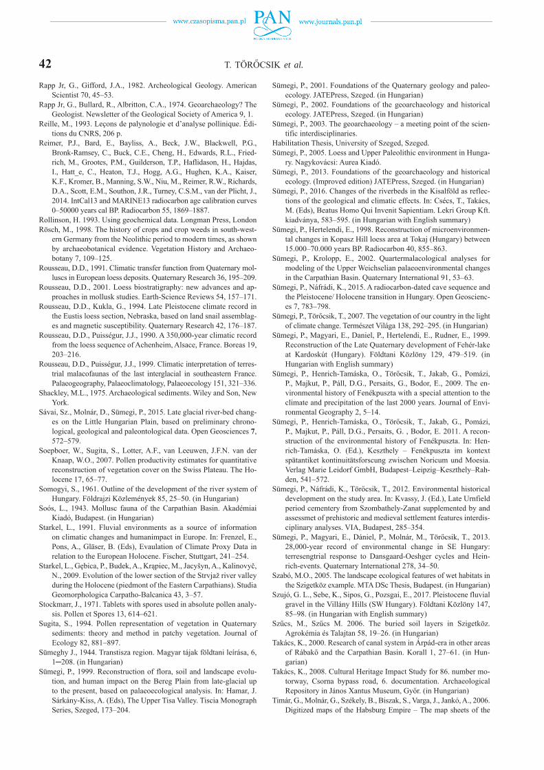
42 T. TÖRŐCSIK et al.
Rapp Jr, G., Gifford, J.A., 1982. Archeological Geology. American Scientist 70, 45–53.
Rapp Jr, G., Bullard, R., Albritton, C.A., 1974. Geoarchaeology? The Geologist. Newsletter of the Geological Society of America 9, 1.
Reille, M., 1993. Leçons de palynologie et d’analyse pollinique. Édi-tions du CNRS, 206 p.
Reimer, P.J., Bard, E., Bayliss, A., Beck, J.W., Blackwell, P.G., Bronk-Ramsey, C., Buck, C.E., Cheng, H., Edwards, R.L., Fried-rich, M., Grootes, P.M., Guilderson, T.P., Haflidason, H., Hajdas, I., Hatt_e, C., Heaton, T.J., Hogg, A.G., Hughen, K.A., Kaiser, K.F., Kromer, B., Manning, S.W., Niu, M., Reimer, R.W., Richards, D.A., Scott, E.M., Southon, J.R., Turney, C.S.M., van der Plicht, J., 2014. IntCal13 and MARINE13 radiocarbon age calibration curves 0–50000 years cal BP. Radiocarbon 55, 1869–1887.
Rollinson, H. 1993. Using geochemical data. Longman Press, LondonRösch, M., 1998. The history of crops and crop weeds in south-west-
ern Germany from the Neolithic period to modern times, as shown by archaeobotanical evidence. Vegetation History and Archaeo-botany 7, 109–125.
Rousseau, D.D., 1991. Climatic transfer function from Quaternary mol-luscs in European loess deposits. Quaternary Research 36, 195–209.
Rousseau, D.D., 2001. Loess biostratigraphy: new advances and ap-proaches in mollusk studies. Earth-Science Reviews 54, 157–171.
Rousseau, D.D., Kukla, G., 1994. Late Pleistocene climate record in the Eustis loess section, Nebraska, based on land snail assemblag-es and magnetic susceptibility. Quaternary Research 42, 176–187.
Rousseau, D.D., Puisségur, J.J., 1990. A 350,000-year climatic record from the loess sequence of Achenheim, Alsace, France. Boreas 19, 203–216.
Rousseau, D.D., Puisségur, J.J., 1999. Climatic interpretation of terres-trial malacofaunas of the last interglacial in southeastern France. Palaeogeography, Palaeoclimatology, Palaeoecology 151, 321–336.
Shackley, M.L., 1975. Archaeological sediments. Wiley and Son, New York.
Sávai, Sz., Molnár, D., Sümegi, P., 2015. Late glacial river-bed chang-es on the Little Hungarian Plain, based on preliminary chrono-logical, geological and paleontological data. Open Geosciences 7, 572–579.
Soepboer, W., Sugita, S., Lotter, A.F., van Leeuwen, J.F.N. van der Knaap, W.O., 2007. Pollen productivity estimates for quantitative reconstruction of vegetation cover on the Swiss Plateau. The Ho-locene 17, 65–77.
Somogyi, S., 1961. Outline of the development of the river system of Hungary. Földrajzi Közlemények 85, 25–50. (in Hungarian)
Soós, L., 1943. Mollusc fauna of the Carpathian Basin. Akadémiai Kiadó, Budapest. (in Hungarian)
Starkel, L., 1991. Fluvial environments as a source of information on climatic changes and humanimpact in Europe. In: Frenzel, E., Pons, A., Gläser, B. (Eds), Evaulation of Climate Proxy Data in relation to the European Holocene. Fischer, Stuttgart, 241–254.
Starkel, L., Gębica, P., Budek, A., Krąpiec, M., Jacyšyn, A., Kalinovyč, N., 2009. Evolution of the lower section of the Strvjaž river valley during the Holocene (piedmont of the Eastern Carpathians). Studia Geomorphologica Carpatho-Balcanica 43, 3–57.
Stockmarr, J., 1971. Tablets with spores used in absolute pollen analy-sis. Pollen et Spores 13, 614–621.
Sugita, S., 1994. Pollen representation of vegetation in Quaternary sediments: theory and method in patchy vegetation. Journal of Ecology 82, 881–897.
Sümeghy J., 1944. Transtisza region. Magyar tájak földtani leírása, 6, 1─208. (in Hungarian)
Sümegi, P., 1999. Reconstruction of flora, soil and landscape evolu-tion, and human impact on the Bereg Plain from late-glacial up to the present, based on palaeoecological analysis. In: Hamar, J. Sárkány-Kiss, A. (Eds), The Upper Tisa Valley. Tiscia Monograph Series, Szeged, 173–204.
Sümegi, P., 2001. Foundations of the Quaternary geology and paleo-ecology. JATEPress, Szeged. (in Hungarian)
Sümegi, P., 2002. Foundations of the geoarchaeology and historical ecology. JATEPress, Szeged. (in Hungarian)
Sümegi, P., 2003. The geoarchaeology – a meeting point of the scien-tific interdisciplinaries.
Habilitation Thesis, University of Szeged, Szeged.Sümegi, P., 2005. Loess and Upper Paleolithic environment in Hunga-
ry. Nagykovácsi: Aurea Kiadó.Sümegi, P., 2013. Foundations of the geoarchaeology and historical
ecology. (Improved edition) JATEPress, Szeged. (in Hungarian)Sümegi, P., 2016. Changes of the riverbeds in the Kisalföld as reflec-
tions of the geological and climatic effects. In: Csécs, T., Takács, M. (Eds), Beatus Homo Qui Invenit Sapientiam. Lekri Group Kft. kiadványa, 583–595. (in Hungarian with English summary)
Sümegi, P., Hertelendi, E., 1998. Reconstruction of microenvironmen-tal changes in Kopasz Hill loess area at Tokaj (Hungary) between 15.000–70.000 years BP. Radiocarbon 40, 855–863.
Sümegi, P., Krolopp, E., 2002. Quartermalacological analyses for modeling of the Upper Weichselian palaeoenvironmental changes in the Carpathian Basin. Quaternary International 91, 53–63.
Sümegi, P., Náfrádi, K., 2015. A radiocarbon-dated cave sequence and the Pleistocene/ Holocene transition in Hungary. Open Geoscienc-es 7, 783–798.
Sümegi, P., Törőcsik, T., 2007. The vegetation of our country in the light of climate change. Természet Világa 138, 292–295. (in Hungarian)
Sümegi, P., Magyari, E., Daniel, P., Hertelendi, E., Rudner, E., 1999. Reconstruction of the Late Quaternary development of Fehér-lake at Kardoskút (Hungary). Földtani Közlöny 129, 479–519. (in Hungarian with English summary)
Sümegi, P., Henrich-Tamáska, O., Törőcsik, T., Jakab, G., Pomázi, P., Majkut, P., Páll, D.G., Persaits, G., Bodor, E., 2009. The en-vironmental history of Fenékpuszta with a special attention to the climate and precipitation of the last 2000 years. Journal of Envi-ronmental Geography 2, 5–14.
Sümegi, P., Henrich-Tamáska, O., Törőcsik, T., Jakab, G., Pomázi, P., Majkut, P., Páll, D.G., Persaits, G. , Bodor, E. 2011. A recon-struction of the environmental history of Fenékpuszta. In: Hen-rich-Tamáska, O. (Ed.), Keszthely – Fenékpuszta im kontext spätantiket kontinuitätsforscung zwischen Noricum und Moesia. Verlag Marie Leidorf GmbH, Budapest–Leipzig–Keszthely–Rah-den, 541–572.
Sümegi, P., Náfrádi, K., Törőcsik, T., 2012. Environmental historical development on the study area. In: Kvassy, J. (Ed.), Late Urnfield period cementery from Szombathely-Zanat supplemented by and assessmet of prehistoric and medieval settlement features interdis-ciplinary analyses. VIA, Budapest, 285–354.
Sümegi, P., Magyari, E., Dániel, P., Molnár, M., Törőcsik, T., 2013. 28,000-year record of environmental change in SE Hungary: terresengtrial response to Dansgaard-Oeshger cycles and Hein-rich-events. Quaternary International 278, 34–50.
Szabó, M.O., 2005. The landscape ecological features of wet habitats in the Szigetköz example. MTA DSc Thesis, Budapest. (in Hungarian)
Szujó, G. L., Sebe, K., Sipos, G., Pozsgai, E., 2017. Pleistocene fluvial gravel in the Villány Hills (SW Hungary). Földtani Közlöny 147, 85–98. (in Hungarian with English summary)
Szűcs, M., Szűcs M. 2006. The buried soil layers in Szigetköz. Agrokémia és Talajtan 58, 19–26. (in Hungarian)
Takács, K., 2000. Research of canal system in Árpád-era in other areas of Rábakő and the Carpathian Basin. Korall 1, 27–61. (in Hun-garian)
Takács, K., 2008. Cultural Heritage Impact Study for 86. number mo-torway, Csorna bypass road, 6. documentation. Archaeological Repository in János Xantus Museum, Győr. (in Hungarian)
Timár, G., Molnár, G., Székely, B., Biszak, S., Varga, J., Jankó, A., 2006. Digitized maps of the Habsburg Empire – The map sheets of the
ENVIRONMENTAL HISTORY OF THE CSORNA PLAIN (WESTERN DANUBE PLAIN, HUNGARY) 43second military survey and their georeferenced version. Arcanum, Budapest, 1–59.
Timár, G., Biszak, S., Székely, B., Molnár, G., 2011. Digitized Maps of the Habsburg Military Surveys: Overview of the Project of ARCANUM Ltd. (Hungary). In: Jobst, M. (Ed.), Preservation in digital cartography. Lecture Notes in Geoinformation and Cartog-raphy, Springer, Berlin–Heidelberg, 273–283.
Tomka, P., 1996. Frühawarenzeitliche Hirten in der Kleinen Tiefebe-ne. In: Bialeková, D., Zábojník, J. (Eds), Ethnische und kulturelle Verhältnisse an der mittleren Donau vom 6. bis 11. Jahrhundert. Verlag der Slowakischen Akademie der Wissenschaften, Bratislava, 141–149.
Tomka, P., 2008a. Langobards ont he Little Hungarian Plain. Lango-bardok a Kisalföldön. In: Molnár, A., Nagy, A., Tomka, P. (Eds), They came and went. Langobards and Avars on the Little Hungarian Plain. Győr-Moson-Sopron Country Museum, Exhibiton leader 3., Győr, 7–29. (in Hungarian)
Tomka, P., 2008b. Early and Middle Avar cementery in the area of the shopping centre at Ménfőcsanak. In: Molnár, A., Nagy, A., Tomka, P. (Eds), They came and went. Langobards and Avars on the Little Hungarian Plain. Győr-Moson-Sopron Country Museum, Exhibi-ton leader 3., Győr, 123–133. (in Hungarian)
Törőcsik, T., Sümegi, P., Majkut, P., Páll, D.G., Persaits, G., Tóth, Cs., Veres, Z., Sümegi, B.P., 2014. The development of the Ko-lon lake at Izsák according to radiocarbon-dated paleoecolog-ical data. In: Sümegi, P. (Ed.), Environmental geological and environmental historical researhes in the Danubian part of the Great Hungarian Plain. GeoLitera Kiadó, Szeged, 173–184. (in Hungarian)
Törőcsik, T., Töviskés, R., Bodor, E., Sümegi, P., 2015. The impor-tance of pollen studies from paleoecological sites in archeobotanic analyses. In: Törőcsik, T., Náfrádi, K., Sümegi, P. (Eds), Complex archeobotany. GeoLitera, Szeged, 209–237.
Troels-Smith, J., 1955. Karakterisering af lose jordater. Danmarks Ge-ologiske Undersogelse, ser. IV. (10).
Újvári, G., Molnár, M., Novothny Á., Páll-Gergely B., Kovács J., Várh-egyi A., 2014. AMS 14C and OSL/IRSL dating of the Dunaszekcső loess sequence (Hungary): chronology for 20 to 150 ka and im-plications for establishing reliable age-depth models for the last 40 ka. Quaternary Science Reviews 106, 140–154.
Vaday, A., 2003. Chronological charts. In: Visy, Zs. (Ed.) Hungarian Archaeology at the turn of the Millennium. Nemzeti Kulturális
Örök ség Minisztériuma, Teleki László Alapítványa, Budapest, 473–475.
Virág, Zs., Figler, A., 2007. Data on the settlement history of the Late Lengyel period of Transdanubia ont he basis of two sites from Kisal-föld (Small Hungarian Plain) (A preliminary evaluation of the sites Győr-Szabadrétdomb and Mosonszentmiklós-Pálmajor). In: Kozlo-wski, J.K, Raczky, P. (Eds), The Lengyel, Polgár and related cultures in the Middle/Late Neolithic in Central Europe. Krakow, 345–364.
Von Grafenstein, U., Erlenkeuser, H., Müller, J., Jouzel, J., Johnsen, S., 1998. The cold event 8200 years ago documented in oxygen isotope records of precipitation in Europe and Greenland. Climate Dyna-mics 14, 73–81.
Welter-Schultes, F.W., 2012. European non-marine molluscs, a guide for species identification. Planet Poster Edition, Göttingen.
Willis, K.J., 2007. The impact of the Early Neolithic Körös culture on the landscape: evidence from palaeoecological investigations of the Kiri-tó. In: Whittle, A. (Ed.), The Ecsegfalva Project. Varia Archaeologica Hungarica sorozat, XXI. kötet, MTA Régészeti In-tézet, Budapest, 83–98.
Willis, K.J., Sümegi, P., Braun, M., Tóth, A., 1995. The Late Quaterna-ry environmental history of Bátorliget, N.E. Hungary. Palaeogeo-graphy, Palaeoclimatology, Palaeoecology 118, 25–47.
Willis, K.J., Braun, M., Sümegi, P., Tóth A., 1997. Does soil change cause vegetation change or vice-versa? A temporal perspective from Hungary. Ecology 78, 740–750.
Willis, K.J., Sümegi, P., Braun, M., Bennett, K.D., Tóth, A., 1998. Pre-historic land degradation In Hungary: who, how and why? Anti-quity 72, 101–113.
Xu, B., Gu, Z., Han, J., Hao, Q., Lu, Y., Wang, L., Wu, N., Peng, Y., 2011. Radiocarbon age anomalies of land snail shells in the Chi-nese Loess Plateau. Quaternary Geochronology 6, 383–389.
Zar, J., 1990. Biostatistical Analysis. Englewood Cliffs, New York.Zámolyi, A., Székely, B., Draganits, E., Timár, G., 2010. Neotectonic
control on river sinuosity at the western margin of the Little Hun-garian Plain. Geomorphology 122, 231–243.
Zhou, R., Liu, Q., Jackson, M.J., 2004. Paleoenvironmental signifi-cance of the magnetic fabrics in Chinese loess-paleosols since the last interglacial (<130 ka). Earth and Planetary Science Letters 221, 55–69.
Zólyomi, B., 1952. The history of the vegetation of Hungary in the last ice age. Magyar Tudományos Akadémia Biológiai Osztályának Közleményei 1, 491–544.


![Wwf Restoration Potential Danube[1]](https://img.pdfslide.tips/doc/110x75/577cd8051a28ab9e78a03ffb/wwf-restoration-potential-danube1.jpg)