Embed Size (px)
Citation preview
1
「海の論考」
Environmental Impact of Oil Spill Incidents on Coral Reefs and Mangrove Forests, and Monitoring —Toward Environmental Restoration in Mauritius Research Fellows Junko Toyoshima, Nobuko Nakamura, Iwao Fujii, Senior Research Fellow Atsushi Watanabe, Ocean Policy Research Institute of the Sasakawa Peace Foundation
NOTE: The following is an English translation of an original Japanese article issued in October 2020.
1. Introduction
On July 25, 2020, the bulk carrier MV “WAKASHIO” ran aground off the coast of the Republic of Mauritius (hereafter, Mauritius), damaging the ship’s hull and causing an oil spill from August 6. This paper organizes the environmental impacts of this accident on coastal ecosystems and the points that should be considered in carrying out medium- to long-term monitoring. It describes the characteristics of the coral reefs and mangrove ecosystems of Mauritius that adjoin the site of the grounding incident (Section 2), with reference to the environmental impact of oil spill incidents that have occurred along coral reefs or tropical coastal ecosystems in the past (Section 3); it also organizes the necessary approaches to short- to medium- and long-term monitoring in the case of the Mauritius incident or similar incidents (Section 4). Finally, based on these, it provides an outlook for the restoration of coral reefs and mangrove forests in Mauritius (Section 5).
2. Characteristics of Mauritius’ coastal environment
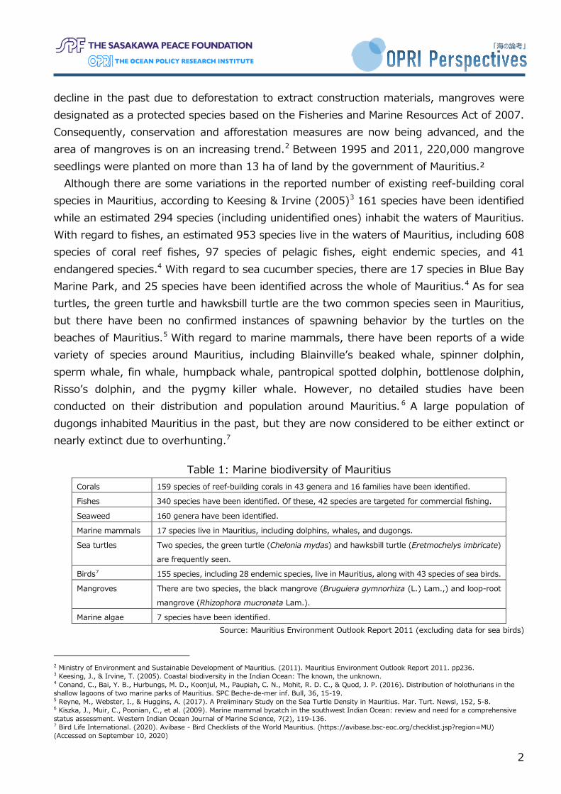
Mauritius is located in the tropical region of the southwest Indian Ocean, and its national territory comprises the main island of Mauritius, along with numerous small islands. The largest of these, Mauritius Island, has a coastline extending for 322 km, and is surrounded by approximately 300 km2 of coral reefs and mangrove forests. The marine biodiversity of Mauritius is shown in Table 1, according to reports published by the Ministry of Environment, Solid Waste Management and Climate Change of Mauritius and other materials. The waters around Mauritius could be described as having a high degree of biodiversity, and a wide variety of organisms inhabit these waters. The islands in the region, including Madagascar and Mauritius, have also been designated as biodiversity hotspots (however, classification was based on the plant ecosystems on land). The coral reefs of Mauritius have been impacted by factors such as mass coral bleaching events due to water temperature anomalies, coral diseases, and the occurrence of coral predators. However, about 40% coral cover is observed on average in places where monitoring is carried out.1 With regard to mangroves, despite a 1 Obura, D., Gudka, M., Rabi, F. A.et al. (2017). Coral reef status report for the Western Indian Ocean (2017). In Nairobi convention. Global Coral Reef Monitoring Network (GCRMN)/International Coral Reef Initiative (ICRI).
OPRI Perspectives No.13 [2020]
2
「海の論考」
decline in the past due to deforestation to extract construction materials, mangroves were designated as a protected species based on the Fisheries and Marine Resources Act of 2007. Consequently, conservation and afforestation measures are now being advanced, and the area of mangroves is on an increasing trend.2 Between 1995 and 2011, 220,000 mangrove seedlings were planted on more than 13 ha of land by the government of Mauritius.²
Although there are some variations in the reported number of existing reef-building coral species in Mauritius, according to Keesing & Irvine (2005)3 161 species have been identified while an estimated 294 species (including unidentified ones) inhabit the waters of Mauritius. With regard to fishes, an estimated 953 species live in the waters of Mauritius, including 608 species of coral reef fishes, 97 species of pelagic fishes, eight endemic species, and 41 endangered species.4 With regard to sea cucumber species, there are 17 species in Blue Bay Marine Park, and 25 species have been identified across the whole of Mauritius.4 As for sea turtles, the green turtle and hawksbill turtle are the two common species seen in Mauritius, but there have been no confirmed instances of spawning behavior by the turtles on the beaches of Mauritius.5 With regard to marine mammals, there have been reports of a wide variety of species around Mauritius, including Blainville’s beaked whale, spinner dolphin, sperm whale, fin whale, humpback whale, pantropical spotted dolphin, bottlenose dolphin, Risso’s dolphin, and the pygmy killer whale. However, no detailed studies have been conducted on their distribution and population around Mauritius. 6 A large population of dugongs inhabited Mauritius in the past, but they are now considered to be either extinct or nearly extinct due to overhunting.7
Table 1: Marine biodiversity of Mauritius Corals 159 species of reef-building corals in 43 genera and 16 families have been identified.
Fishes 340 species have been identified. Of these, 42 species are targeted for commercial fishing.
Seaweed 160 genera have been identified.
Marine mammals 17 species live in Mauritius, including dolphins, whales, and dugongs.
Sea turtles Two species, the green turtle (Chelonia mydas) and hawksbill turtle (Eretmochelys imbricate)
are frequently seen.
Birds7 155 species, including 28 endemic species, live in Mauritius, along with 43 species of sea birds.
Mangroves There are two species, the black mangrove (Bruguiera gymnorhiza (L.) Lam.,) and loop-root
mangrove (Rhizophora mucronata Lam.).
Marine algae 7 species have been identified. Source: Mauritius Environment Outlook Report 2011 (excluding data for sea birds)
2 Ministry of Environment and Sustainable Development of Mauritius. (2011). Mauritius Environment Outlook Report 2011. pp236. 3 Keesing, J., & Irvine, T. (2005). Coastal biodiversity in the Indian Ocean: The known, the unknown. 4 Conand, C., Bai, Y. B., Hurbungs, M. D., Koonjul, M., Paupiah, C. N., Mohit, R. D. C., & Quod, J. P. (2016). Distribution of holothurians in the shallow lagoons of two marine parks of Mauritius. SPC Beche-de-mer inf. Bull, 36, 15-19. 5 Reyne, M., Webster, I., & Huggins, A. (2017). A Preliminary Study on the Sea Turtle Density in Mauritius. Mar. Turt. Newsl, 152, 5-8. 6 Kiszka, J., Muir, C., Poonian, C., et al. (2009). Marine mammal bycatch in the southwest Indian Ocean: review and need for a comprehensive status assessment. Western Indian Ocean Journal of Marine Science, 7(2), 119-136. 7 Bird Life International. (2020). Avibase - Bird Checklists of the World Mauritius. (https://avibase.bsc-eoc.org/checklist.jsp?region=MU) (Accessed on September 10, 2020)
3
「海の論考」
As Mauritius is an island country, it also has a thriving fishery industry. According to the Food and Agriculture Organization (FAO), Mauritius records an annual catch of 250,000 t (2017) and an annual consumption per capita of 23.2 kg (2016).8 Its fishery industry can be broadly classified into three categories: small-scale fisheries that operate in reef lagoons and their immediate periphery, bank fisheries that operate offshore, and tuna fisheries that operate in the open ocean.9 A wide variety of fish is caught and traded in fish markets and other places,9 such as snappers, parrotfish, emperors, breams, wrasses, surgeon fishes, triggerfishes, tuna (albacore, yellowfin), marlin, octopus, and red tilapia.
There are eight marine protected areas around Mauritius Island. Two of these are marine parks, while six are protected fishery reserves. Of the two marine protected areas that are marine parks, Blue Bay Marine Park is located near to the site of the WAKASHIO grounding incident (Figure 1). Blue Bay Marine Park was designated as a national park in October 1997, then as a marine protected area in June 2000. It covers an area of 353 ha, and has a diverse ecosystem within its boundaries, including coral reefs, mangroves, and seagrass beds. It is inhabited by a wide variety of living organisms, such as 108 species of reef-building corals, 233 species of fishes, and 201 species of mollusks.10 Massive coral colonies with diameters exceeding 6m to 7m can also be found here. It is also popular for tourism uses, such as diving, snorkeling, and glass boat cruises. In addition to its designation as a protected area by the Mauritius government, Blue Bay Marine Park has also been designated as a registered wetland under the Ramsar Convention on Wetlands, and as an Ecologically or Biologically Significant Area (EBSA) under the Convention on Biological Diversity. Hence, the value of biodiversity in this marine park is recognized and protected internationally.
The Pointe d'Esny Wetland is not a marine protected area but has also been designated as a registered wetland under the Ramsar Convention on Wetlands. It is also located near to the site of the WAKASHIO grounding incident. Managed by the Forestry Service, the Pointe d'Esny Wetland encompasses an area of 22 ha of shallow, brackish water, with mangrove forests and tidal flats spreading across it.11
8 Food and Agriculture Organization. Fishery and Aquaculture Country Profiles The Republic of Mauritius. http://www.fao.org/fishery/facp/MUS/en (Accessed on September 16, 2020) 9 Kakuma S. (2006). Coastal fisheries resources and eco-system management in Mauritius. Regional Study, (2), 223-236. 10 The Clearing-House Mechanism of the Convention on Biological Diversity. Ecologically or Biologically Significant Areas (EBSAs) Blue Bay Marine Park. https://chm.cbd.int/database/record?documentID=204016 (Accessed on September 10, 2020) 11 AFPBB News. https://www.afpbb.com/articles/-/3298920 (Accessed on September 10, 2020)

4
「海の論考」
Figure 1. Site where the bulk carrier MV WAKASHIO ran aground. (A) shows the site of the grounding incident and the two Ramsar registered wetlands (Pointe d'Esny Wetland and Blue Bay Marine Park), and the estuary of the Rivière des Créoles, where significant damage to the mangroves has been reported. (B) shows an enlarged view of the estuary of the Rivière des Créoles. (C) shows an enlarged view of the area around the Pointe d'Esny Wetland. The yellow boxes shown in (B) and (C) indicate the general area where there are concerns of damage to coral reefs and mangrove forests. (D) shows a bird’s eye view of an enlarged picture of the grounded ship, while the numbers (dates) show the position of the ship from July 25, when it ran aground, to August 5. The yellow lines shown in (A), (B), and (D) indicate the trajectory of the ship, based on data from the automatic identification system (AIS) of the WAKASHIO.
3. Possible environmental impacts on tropical coastal ecosystems, based on past
grounding and oil spill accidents Ship grounding and oil spill accidents, similar to the WAKASHIO grounding and oil spill
accident, have occurred numerous times in the past in sea areas with globally important coral reefs and mangroves. Even if we were to look only at the years since 2010, on April 3, 2010, the Chinese bulk coal carrier “MV Shen Neng 1” ran aground on Douglas Shoal of the Great Barrier Reef in Australia, which is designated as a UNESCO World Heritage site. This raised concerns of damage to the coral reef caused by physical damage from the grounding and the shifting of the vessel after that, as well as from TBT (organic tin compounds) that are used in paints for the bottom of the ship.12 On January 17, 2013, the US Navy minesweeper “USS Guardian” ran aground at Tubbataha Reef in the Philippines, which is registered as a World Heritage site.13 On May 6 the same year, a Chinese fishing vessel also ran aground at Tubbataha Reef.14 15 On February 5, 2019, the bulk carrier “MV Solomon Trader” ran aground
12 Great Barrier Reef Marine Park Authority. (2011). Grounding of the Shen Neng 1 on Douglas Shoal, April 2010: Impact assessment report. 13 AFPBB News. https://www.afpbb.com/articles/-/2922329 (Accessed on September 10, 2020) 14 AFPBB News. https://www.afpbb.com/articles/-/2942468 (Accessed on September 10, 2020) 15 To reduce the risk from such accidents, the Marine Environment Protection Committee (MEPC) of the International Maritime Organization
5
「海の論考」
in a sea area of the Solomon Islands that is registered as a World Heritage site, causing an oil spill.16
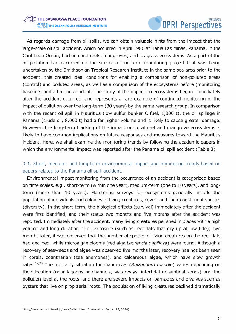
The impact of such grounding accidents and the subsequent oil spills include physical damage to the coral reefs through the grounding itself, the effects of the suspension generated when carbonate coral sands are stirred up from the shallow seabed, and the physical (suffocation) and chemical impacts (toxic components in oil, etc.) of oil on marine life, as well as the indirect impact of oil spills on ecosystems and the secondary damage that arises through clean-up operations, particularly in mangrove forests. Here, we shall discuss mainly the medium- to long-term biological effects of oil spills. Table 2 categorizes the impacts that oil spills have on the respective marine life habitats.
Table 2 Impacts of oil spills on marine life habitats
Habitat Impacted life forms Degree of impact Impact Open oceans Plankton Has impact The oil disperses naturally, and its soluble
components become diluted quickly. However, mass mortality of plankton from oil toxicity could have an impact on the food chain.
Coastal regions Marine mammals Reptiles Adult fish near the coast, and juvenile fish in the shallow waters
Vulnerability to oil pollution
Direct exposure for marine creatures that come to the surface to breathe or come on land to spawn. Long-term accumulation through the food chain.
Intertidal zones / Reef zones, Coastline where rocks, sand and mud emerge over a large surface area at low tide
Shellfish Sea anemone Algae, etc.
Especially significant Direct oil pollution on rocks, sand, and mud during low tide. Exposure at high concentrations.
Swamps Wetlands
Vegetation Mangroves Soil
Significant Depends on pollution level
Respiratory roots of mangrove plants are covered and blocked by oil. Loss of salt balance resulting in defoliation and plant death. Long-term impact of residue in sediments.
Coral reefs Corals Fauna related to coral reefs Seagrass
Significant Depends on pollution level (percentage of toxic components, duration of exposure, other environmental factors)
Growth inhibition, decline in spawning and larval recruitment, coral reef erosion, decline of species diversity, changes to coral reef ecosystems
Seas Sea birds Significant Drop in body temperature due to feather damage caused by the oil, drowning, starvation
Source: ITOPF17, Fukui Prefectural Institute of Public Health and Environmental Science (Midori-net)18
(IMO) designated Tubbataha Reef as a Particularly Sensitive Sea Area (PSSA) in July 2017. International Maritime Organization. http://www.imo.org/en/MediaCentre/PressBriefings/Pages/17-MEPC-71.aspx (Accessed on October 11, 2020) 16 AFPBB News. https://www.afpbb.com/articles/-/3214726 (Accessed on September 10, 2020) 17 ITOPF. https://www.itopf.org/fileadmin/data/Documents/Papers/environ.pdf (Accessed on August 17, 2020) 18 Fukui Prefectural Institute of Public Health and Environmental Science (Midori-net). Tanker NAKHODKA Oil Spill in the Sea of Japan.
6
「海の論考」
As regards damage from oil spills, we can obtain valuable hints from the impact that the large-scale oil spill accident, which occurred in April 1986 at Bahia Las Minas, Panama, in the Caribbean Ocean, had on coral reefs, mangroves, and seagrass ecosystems. As a part of the oil pollution had occurred on the site of a long-term monitoring project that was being undertaken by the Smithsonian Tropical Research Institute in the same sea area prior to the accident, this created ideal conditions for enabling a comparison of non-polluted areas (control) and polluted areas, as well as a comparison of the ecosystems before (monitoring baseline) and after the accident. The study of the impact on ecosystems began immediately after the accident occurred, and represents a rare example of continued monitoring of the impact of pollution over the long-term (30 years) by the same research group. In comparison with the recent oil spill in Mauritius (low sulfur bunker C fuel, 1,000 t), the oil spillage in Panama (crude oil, 8,000 t) had a far higher volume and is likely to cause greater damage. However, the long-term tracking of the impact on coral reef and mangrove ecosystems is likely to have common implications on future responses and measures toward the Mauritius incident. Here, we shall examine the monitoring trends by following the academic papers in which the environmental impact was reported after the Panama oil spill accident (Table 3). 3-1. Short, medium- and long-term environmental impact and monitoring trends based on papers related to the Panama oil spill accident.
Environmental impact monitoring from the occurrence of an accident is categorized based on time scales, e.g., short-term (within one year), medium-term (one to 10 years), and long-term (more than 10 years). Monitoring surveys for ecosystems generally include the population of individuals and colonies of living creatures, cover, and their constituent species (diversity). In the short-term, the biological effects (survival) immediately after the accident were first identified, and their status two months and five months after the accident was reported. Immediately after the accident, many living creatures perished in places with a high volume and long duration of oil exposure (such as reef flats that dry up at low tide); two months later, it was observed that the number of species of living creatures on the reef flats had declined, while microalgae blooms (red alga Laurencia papillosa) were found. Although a recovery of seaweeds and algae was observed five months later, recovery has not been seen in corals, zoantharian (sea anemones), and calcareous algae, which have slow growth rates.19,20 The mortality situation for mangroves (Rhizophora mangle) varies depending on their location (near lagoons or channels, waterways, intertidal or subtidal zones) and the pollution level at the roots, and there are severe impacts on barnacles and bivalves such as oysters that live on prop aerial roots. The population of living creatures declined dramatically
http://www.erc.pref.fukui.jp/news/effect.html (Accessed on August 17, 2020)
7
「海の論考」
and showed no signs of recovery within one year from the accident.19 20 21 As regards reef corals, there has been significant impact on branching corals (Acropora), and massive corals have also declined and are slow growing.22 The short-term impact is clearly related to the oil spill.
In the medium-term, recovery was observed for living creatures in the areas facing the open seas about 1.5 years to 2.5 years after the accident.20 However, the population, cover, number of species and diversity, and growth size of reef corals are still on the decline, and the decline in the cover of branching corals is particularly prominent. Moreover, coral degradation has been observed not only at the surface of the water but in a deeper water zone (3 m – 6 m).22 Alongside algae, recovery has also been observed for calcareous algae and zoantharian (sea anemone).20 Visible recovery of the bivalves on the prop aerial roots of mangroves was not observed even after one year.21 Until this period, studies about reproduction of coral (Siderasterea siderea) had been conducted for 39 months.23 The reduction of the colony sizes and gonad sizes during spawning periods in the oiled reefs links to a reduction in the numbers of viable colonies and gametes in coral colonies.23 Hence, as the impact on corals is especially significant during the phases of reproduction and early life, the season in which the pollution incident occurs is of great importance.24 Even five years after the accident, the reefs are still being exposed to chronic pollution by oil and sediments, and there is no evidence of coral recovery.25
In the long-term, spanning 30 years, cover, number of species, and diversity of coral reefs in the oiled area remain on the decline without signs of recovery. However, coral cover and number of species have similarly been observed to be declining even for coral reefs in the unoiled areas. In conclusion, the impact assessment in the medium- to long-term is cumulative and made more complex by various stress factors apart from the oil spill accident (such as disease, coral bleaching caused by global warming, and sediment runoff). Since these factors drive change in both oiled and unoiled areas, it is likely that a number of complex factors will ultimately hide the effects of the oil spill, making it difficult to extract and evaluate a single impact of the oil spill through long-term monitoring.26
19 Cubit, J. D., Getter, C. D., Jackson, J. B., Garrity, S. D., Caffey, H. M., Thompson, R. C., ... & Marshall, M. J. (1987, April). An oil spill affecting coral reefs and mangroves on the Caribbean coast of Panama. In International Oil Spill Conference (Vol. 1987, No. 1, pp. 401-406). American Petroleum Institute. 20 Jackson, J. B., Cubit, J. D., Keller, B. D., Batista, V., Burns, K., Caffey, H. M., ... & Guzman, H. M. (1989). Ecological effects of a major oil spill on Panamanian coastal marine communities. Science, 243(4887), 37-44. 21 Garrity, S. D., & Levings, S. C. (1993). Effects of an oil spill on some organisms living on mangrove (Rhizophora mangle L.) roots in low wave-energy habitats in Caribbean Panama. Marine Environmental Research, 35(3), 251-271. 22 Guzmán, H. M., Jackson, J. B., & Weil, E. (1991). Short-term ecological consequences of a major oil spill on Panamanian subtidal reef corals. Coral reefs, 10(1), 1-12. 23 Guzmán, H. M., & Holst, I. (1993). Effects of chronic oil-sediment pollution on the reproduction of the Caribbean reef coral Siderastrea siderea. Marine Pollution Bulletin, 26(5), 276-282. 24 Yender, R. A., & Michel, J. M. (Eds.). (2014). Oil spills in coral reefs: Planning & response considerations. US Department of Commerce, National Oceanic and Atmospheric Administration, National Ocean Service, Office of Response and Restoration. 25 Guzmán, H. M., Burns, K. A., & Jackson, J. B. (1994). Injury, regeneration and growth of Caribbean reef corals after a major oil spill in Panama. Marine Ecology Progress Series, 231-241. 26 Guzman, H. M., Kaiser, S., & Weil, E. (2020). Assessing the long-term effects of a catastrophic oil spill on subtidal coral reef communities off
8
「海の論考」
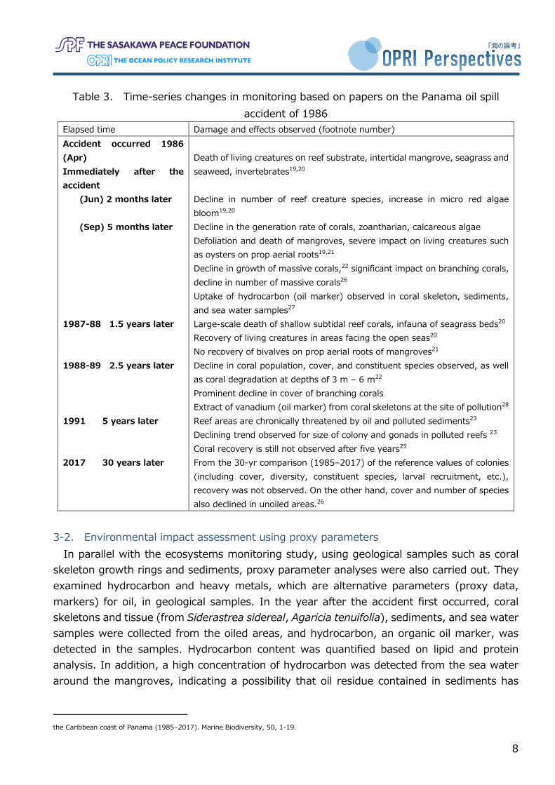
Table 3. Time-series changes in monitoring based on papers on the Panama oil spill accident of 1986
Elapsed time Damage and effects observed (footnote number) Accident occurred 1986 (Apr) Immediately after the accident (Jun) 2 months later (Sep) 5 months later 1987-88 1.5 years later 1988-89 2.5 years later 1991 5 years later 2017 30 years later
Death of living creatures on reef substrate, intertidal mangrove, seagrass and seaweed, invertebrates19,20 Decline in number of reef creature species, increase in micro red algae bloom19,20 Decline in the generation rate of corals, zoantharian, calcareous algae Defoliation and death of mangroves, severe impact on living creatures such as oysters on prop aerial roots19,21 Decline in growth of massive corals,22 significant impact on branching corals, decline in number of massive corals26 Uptake of hydrocarbon (oil marker) observed in coral skeleton, sediments, and sea water samples27 Large-scale death of shallow subtidal reef corals, infauna of seagrass beds20 Recovery of living creatures in areas facing the open seas20 No recovery of bivalves on prop aerial roots of mangroves21 Decline in coral population, cover, and constituent species observed, as well as coral degradation at depths of 3 m – 6 m22 Prominent decline in cover of branching corals Extract of vanadium (oil marker) from coral skeletons at the site of pollution28 Reef areas are chronically threatened by oil and polluted sediments23 Declining trend observed for size of colony and gonads in polluted reefs 23 Coral recovery is still not observed after five years25 From the 30-yr comparison (1985–2017) of the reference values of colonies (including cover, diversity, constituent species, larval recruitment, etc.), recovery was not observed. On the other hand, cover and number of species also declined in unoiled areas.26
3-2. Environmental impact assessment using proxy parameters
In parallel with the ecosystems monitoring study, using geological samples such as coral skeleton growth rings and sediments, proxy parameter analyses were also carried out. They examined hydrocarbon and heavy metals, which are alternative parameters (proxy data, markers) for oil, in geological samples. In the year after the accident first occurred, coral skeletons and tissue (from Siderastrea sidereal, Agaricia tenuifolia), sediments, and sea water samples were collected from the oiled areas, and hydrocarbon, an organic oil marker, was detected in the samples. Hydrocarbon content was quantified based on lipid and protein analysis. In addition, a high concentration of hydrocarbon was detected from the sea water around the mangroves, indicating a possibility that oil residue contained in sediments has
the Caribbean coast of Panama (1985–2017). Marine Biodiversity, 50, 1-19.
9
「海の論考」
been transported and supplied to coral colonies for a long period of time.27 Vanadium, which is also a heavy metal- oil marker, was detected from another set of Porites coral growth rings (Siderastrea sidereal). This boring core records 100 years, from 1888 to 1989; vanadium contamination began with the start of refinery operations in 1962, suggesting that the main degradation process along the coast started from the 1960s. This also provides valuable information as a baseline for accident impact assessment.28
Geological samples have varve (annual rings), making it possible to reconstruct past environmental records. However, the scope of reconstruction is limited depending on when the samples were collected. If they were collected several decades after the accident, it will be possible to verify how long the effects of the accident will last. In this way, the method performs a similar role as environmental monitoring. However, it is effective only in cases where skeleton samples can be collected that were not subject to instantaneous dying as a result of accidents or environmental changes.
By combining the results of both the ecosystem monitoring and the pre-accident situation reconstructed from the coral skeletons and sediment samples, we can see that prior to the oil spill accident in 1986, degradation of the coral reef ecosystem in the lagoon in Panama had already begun from the 1960s. As it is likely that the coral reef environment before the accident was not an ideal baseline, there is a need to consider a standard by which to estimate the achievement of the environmental recovery after the accident. 3-3.Impact of oil spills on mangroves
Generally, the attachment and cover of oil to the respiratory roots of mangroves, viviparous seeds, and sediments cause breathing difficulties for the mangroves as well as creatures such as bivalves living on the prop aerial roots, and affect them due to the toxicity of the oil.21 29 Furthermore, the loss of salt balance leads to mangrove defoliation and withering. Residual oil in the sediments may seep out into the sea over several years and be carried to neighboring coral reef areas, and this could in turn have an impact on the ecosystem over the long-term.21,29 While it is necessary to carry out oil removal urgently, there are concerns that humans stepping into the mangrove wetlands for clean-up operations may cause secondary damage to roots and saplings, or spread the oil pollution into the sediments, thereby prolonging the adverse effects.30 The accident at Bahia Las Minas occurred in April 1986 (dry season). Annual rainfall in Panama exceeds 3,200 mm, but rainfall in the dry season is extremely low (it is at the lowest level from February to March, and monthly rainfall in April is about 100 mm). The fluctuation
27 Burns, K. A., & Knap, A. H. (1989). The Bahia Las Minas oil spill hydrocarbon uptake by reef building corals. Marine Pollution Bulletin, 20(8), 391-398. 28 Guzman, H. M., & Jarvis, K. E. (1996). Vanadium century record from Caribbean reef corals: a tracer of oil pollution in Panama. Ambio, 25(8), 523-526. 29 Duke, N. C., Pinzón M, Z. S., & Prada T, M. C. (1997). Large-Scale Damage to Mangrove Forests Following Two Large Oil Spills in Panama 1. Biotropica, 29(1), 2-14. 30 Hoff, R. Z. (2002). Oil spills in mangroves: planning & response considerations. National Oceanic and Atmospheric Administration, NOAA Ocean Service, Office of Response and Restoration.
10
「海の論考」
range of the tide level is 62 cm, and average tide level is at its lowest around March and April. In the driest seasons of the year, the drifting oil enters roots in mangrove wetlands and crab burrows, making the pollution of sediments severe (oil exposure in the vertical direction). After that, when rainfall (600 mm/month) and tide levels reach their highest points around October and November (rainy season), the rise in water levels once again spreads the pollution to the surrounding environments. While a major accident also occurred in Panama in December 1968, this suggests that the impact on mangrove forests differs depending on the season when the accident occurred.29 3-4. Impact of oil spills on fishes
As regards the impact on fishes in coral reef areas, direct exposure to oil in the coastal regions is lethal, and there have been reports of changes to the diet of the red snapper before and after the large-scale oil spill accident on the seabed in the Gulf of Mexico in 2010.31 While diet varies according to the size of the fish, over the year following the accident the diet for fishes that feed mainly on zooplankton changed to a diet of living organisms that are higher up the food chain or to pelagic zooplankton. The effects of oil toxicity leads to a decrease in the quantity of zooplankton production, and this impact on the ecosystem emerges through the food chain. 4. Monitoring environmental impacts, and an approach to environmental recovery 4-1. Implementation of environmental monitoring
Environmental monitoring after a ship grounding and oil spill accident is vital to assess the impact that the accident could have on marine ecosystems and local communities (fisheries, tourism industries, etc.).24 WAKASHIO’s grounding and oil spill occurred in a coastal region where diverse, complex, and valuable ecosystems exist, including coral reefs and mangrove forests (Section 2). Due to various possible impacts of the accident, “multi-layered” impact assessment is necessary in post-accident monitoring. Based on the environmental impacts discussed in Section 3, this section offers an overview of environmental monitoring that is necessary in the event of similar ship groundings and oil spill accidents in shallow tropical waters.
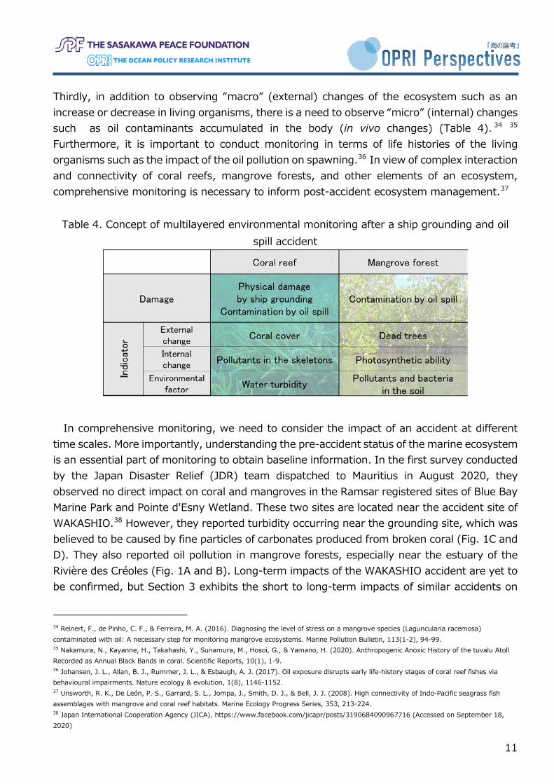
Firstly, it is necessary to assess two impacts of an accident: the impacts of a ship grounding and oil spill, respectively (Table 4). Secondly, when assessing the impacts of an accident, we need to observe the impacts on two components of the ecosystem: living organisms (i.e. coral and mangroves) and environmental factors (e.g. water turbidity and soil) (Table 4).32 33
31 Tarnecki, J. H., & Patterson III, W. F. (2015). Changes in red snapper diet and trophic ecology following the Deepwater Horizon oil spill. Marine and Coastal Fisheries, 7(1), 135-147. 32 International Petroleum Industry Environmental Conservation Association. (1992). Biological impacts of oil pollution: coral reefs. V. 3. 33 Machado, L. F., de Assis Leite, D. C., da Costa Rachid, C. T. C., Paes, J. E., Martins, E. F., Peixoto, R. S., & Rosado, A. S. (2019). Tracking mangrove oil bioremediation approaches and bacterial diversity at different depths in an in situ mesocosms system. Frontiers in microbiology, 10, 2107.
11
「海の論考」
Thirdly, in addition to observing “macro” (external) changes of the ecosystem such as an increase or decrease in living organisms, there is a need to observe “micro” (internal) changes such as oil contaminants accumulated in the body (in vivo changes) (Table 4). 34 35 Furthermore, it is important to conduct monitoring in terms of life histories of the living organisms such as the impact of the oil pollution on spawning.36 In view of complex interaction and connectivity of coral reefs, mangrove forests, and other elements of an ecosystem, comprehensive monitoring is necessary to inform post-accident ecosystem management.37
Table 4. Concept of multilayered environmental monitoring after a ship grounding and oil spill accident
In comprehensive monitoring, we need to consider the impact of an accident at different time scales. More importantly, understanding the pre-accident status of the marine ecosystem is an essential part of monitoring to obtain baseline information. In the first survey conducted by the Japan Disaster Relief (JDR) team dispatched to Mauritius in August 2020, they observed no direct impact on coral and mangroves in the Ramsar registered sites of Blue Bay Marine Park and Pointe d'Esny Wetland. These two sites are located near the accident site of WAKASHIO.38 However, they reported turbidity occurring near the grounding site, which was believed to be caused by fine particles of carbonates produced from broken coral (Fig. 1C and D). They also reported oil pollution in mangrove forests, especially near the estuary of the Rivière des Créoles (Fig. 1A and B). Long-term impacts of the WAKASHIO accident are yet to be confirmed, but Section 3 exhibits the short to long-term impacts of similar accidents on
34 Reinert, F., de Pinho, C. F., & Ferreira, M. A. (2016). Diagnosing the level of stress on a mangrove species (Laguncularia racemosa) contaminated with oil: A necessary step for monitoring mangrove ecosystems. Marine Pollution Bulletin, 113(1-2), 94-99. 35 Nakamura, N., Kayanne, H., Takahashi, Y., Sunamura, M., Hosoi, G., & Yamano, H. (2020). Anthropogenic Anoxic History of the tuvalu Atoll Recorded as Annual Black Bands in coral. Scientific Reports, 10(1), 1-9. 36 Johansen, J. L., Allan, B. J., Rummer, J. L., & Esbaugh, A. J. (2017). Oil exposure disrupts early life-history stages of coral reef fishes via behavioural impairments. Nature ecology & evolution, 1(8), 1146-1152. 37 Unsworth, R. K., De León, P. S., Garrard, S. L., Jompa, J., Smith, D. J., & Bell, J. J. (2008). High connectivity of Indo-Pacific seagrass fish assemblages with mangrove and coral reef habitats. Marine Ecology Progress Series, 353, 213-224. 38 Japan International Cooperation Agency (JICA). https://www.facebook.com/jicapr/posts/3190684090967716 (Accessed on September 18, 2020)
12
「海の論考」
coral reefs, mangrove forests, and other living organisms (Table 3). It is therefore important to consider the environmental changes caused by the accident on different time scales. Furthermore, it is necessary to obtain baseline information in order to understand the original status of the ecosystems. 39 In the case of an impacted ecosystem for which no such information is available, unimpacted sites of a similar environment can be used as a reference site or proxy for the baseline information.40 Such baseline or reference information serves as criteria to assess the recovery status of the ecosystem. 4-2.Environmental monitoring methods
There are various methods of environmental monitoring and a wide range of indicators. Before discussing details of post-accident monitoring, this paper introduces monitoring methods for coral reefs and mangrove forests.
With regard to monitoring of coral reefs, coral cover (percentage of the reef surface that is occupied by living coral) is a common indicator. Frequently used methods for measuring coral cover are transect and quadrat.41 The transect is a method for observing the presence or absence of different benthic substrates (coral, seagrass, sand, etc.) found along a line set on the sea bottom. On the other hand, the quadrat is a method for observing the presence or absence of seabed substrates within a defined square border. In monitoring, there are cases where the transect and quadrat are set in a fixed position, and cases where they are placed randomly. A combination of these methods is also used by setting the quadrat at even intervals or randomly along with a transect line. Data are recorded on water-resistant paper (handwritten) or using other tools such as cameras or videos. As the transect method involves making observations along a straight line, it requires a relatively short time to estimate coral cover. For this reason, it is an effective method for estimating coral cover in wider areas.42 In contrast, the quadrat method requires recording data for the entire substrate within squares. Hence, it takes time to obtain data, especially when data are recorded manually. However, compared to the transect, it allows us to obtain more detailed and accurate data such as the recruitment status of juvenile coral.43 Regardless of the method, it is necessary to take into consideration the fact that the growth speed of coral and their tolerance to stress (e.g., rising water temperature) are different depending on their physical structure (shapes). For example, branch-shaped acroporidae are more susceptible to physical damage and have poor stress tolerance.44 In contrast, poritidae, many of which are clump-shaped, tend to be more tolerant
39 Smith, J. E., Brainard, R., Carter, A., Grillo, S., Edwards, C., Harris, J., ... & Vroom, P. S. (2016). Re-evaluating the health of coral reef communities: baselines and evidence for human impacts across the central Pacific. Proceedings of the Royal Society B: Biological Sciences, 283(1822), 20151985. 40 Hill, J. J., & Wilkinson, C. C. (2004). Methods for ecological monitoring of coral reefs: a resource for managers. Australian Institute of Marine Science (AIMS). 41 English, S. S., Wilkinson, C. C., & Baker, V. V. (1997). Survey manual for tropical marine resources. Australian Institute of Marine Science. 42 Done, T., Roelfsema, C., Harvey, A., Schuller, L., Hill, J., Schläppy, M. L., ... & Loder, J. (2017). Reliability and utility of citizen science reef monitoring data collected by Reef Check Australia, 2002–2015. Marine Pollution Bulletin, 117(1-2), 148-155. 43 Leujak, W., & Ormond, R. F. G. (2007). Comparative accuracy and efficiency of six coral community survey methods. Journal of Experimental Marine Biology and Ecology, 351(1-2), 168-187. 44 Manzello, D. P. (2010). Coral growth with thermal stress and ocean acidification: lessons from the eastern tropical Pacific. Coral reefs, 29(3), 749-758.
13
「海の論考」
to physical damage and environment stress. Therefore, when coral cover is used as an indicator, there is a need to obtain data for the respective type of coral.
With regard to monitoring of mangrove forests, there are various measurement items, but transect and quadrat are commonly used for monitoring. For example, the position, species, and status of mangrove trees at the survey site are recorded using the transect method. Alternatively, the quadrat method is used to record the species and status of mangroves, and to measure the height, diameter at breast height (DBH), and density of trees.45 Furthermore, as there are differences in the recovery rate of mangroves depending on their locations and environment, there is also a need to record data such as topography and elevation. For instance, mangroves facing the open sea can easily be affected by oil pollution. In contrast, the impact of pollution on trees inside mangrove forests tend to linger for a longer time, which may result in slower recovery.46 Thus, location is one of the key factors. In addition to field surveys, remote sensing technologies such as satellite and drone imaging are effective tools to capture the status of mangrove forests at larger scales or when it is difficult to enter the forests due to their complex structure.47 Many of the images from these tools are spectral images produced using electromagnetic waves including ultraviolet rays, visible rays, and infrared rays, as well as images from synthetic aperture radar (SAR). These images are used to estimate the distribution status of vegetation as a vegetation index.
In long-term monitoring, it is also important to record the environmental factors that could have an impact on an increase or decrease in coral and mangroves (e.g., water temperature, air temperature, water turbidity, and soil salinity). Furthermore, a suitable method should be selected depending on the quality of data required, available resources (e.g., personnel and budget), and sea conditions at the study site. 4-3.Environmental monitoring after a ship grounding and oil spill accident 4-3-1.Monitoring the impact of a ship grounding
As explained above, assessing the impact of a ship grounding and oil pollution on the environment is essential. Firstly, in the case of a ship grounding, coral cover should be monitored to assess short-term (physical damage to coral) and medium to long-term impacts (recovery status). Satellite images of the Mauritian coast show that WAKASHIO ran aground on a reef slope or reef margin area known as the outer reef (Fig. 1). The outer reef refers to the boundary between a reef and open sea and is a sea area that embraces high biological diversity as the inner reef does.48 It also serves as a breakwater to protect coastal regions from waves of the open sea.49 A ship grounding and removal of the ship’s hull can physically 45 Ellison, J. (2012). Manual for mangrove monitoring in the Pacific Islands Region. 46 Duke, N. C. (2016). Oil spill impacts on mangroves: recommendations for operational planning and action based on a global review. Marine Pollution Bulletin, 109(2), 700-715. 47 Adamu, B., Tansey, K., & Ogutu, B. (2018). Remote sensing for detection and monitoring of vegetation affected by oil spills. International Journal of Remote Sensing, 39(11), 3628-3645. 48 Cadoret, L., Adjeroud, M., & Tsuchiya, M. (1999). Spatial distribution of chaetodontid fish in coral reefs of the Ryukyu Islands, southern Japan. Journal of the Marine Biological Association of the United Kingdom, 79(4), 725-735. 49 Frihy, O. E., El Ganaini, M. A., El Sayed, W. R., & Iskander, M. M. (2004). The role of fringing coral reef in beach protection of Hurghada, Gulf of Suez, Red Sea of Egypt. Ecological Engineering, 22(1), 17-25.
14
「海の論考」
damage coral reefs, which may result in a weakening of the outer reef’s functions as a breakwater. Moreover, in this accident, white turbidity was found spreading in the inner reef from the grounding site (Fig. 1, C, D). This is believed to be dispersion of carbonate, produced by the damaged coral reef. When fine particles of carbonate increase the turbidity of the water, the zooxanthellae in the corals may become unable to receive sufficient light, and their photosynthetic function may be undermined.50 A similar phenomenon can occur even when these particles cover the coral as sediments.51 When assessing the impact of a ship grounding, it is necessary to survey the status of damaged coral, as well as to observe long-term changes in coral cover. At the same time, there is a need to understand the situation with regard to turbidity and sedimentation, and to record their temporal changes. 4-3-2.Monitoring the impact of oil pollution (1) From the macro perspective of the ecosystem (increase or decrease in living organisms)
Secondly, with regard to the environmental impact of oil pollution, observation on both macro and micro-scales is important. For the macro-scale observation, indicators such as coral cover and areas occupied by dead mangrove trees can be useful indicators. There are concerns of a slowdown in the growth rate of coral, and defoliation and death of mangroves in the short-term. A decline in coral cover and the further impact on mangroves resulting from deposition of pollutants can be the mid to long-term concerns (Table 3). Hence, there is a need to pay close attention to the various changes in the ecosystems in the respective time span.
WAKASHIO was loaded with low sulfur C fuel oil (less than 0.5 % of sulfur content), as stipulated by the International Maritime Organization since January 2020, and this was the first oil spill accident involving this type of the fuel.52 As the low sulfur C fuel oil has a low sulfur content, it has low kinematic viscosity and a high pour point (temperature just before oil solidifies).52 In this accident, approximately 1,000 t of the heavy oil leaked into the sea. It was a relatively small amount of spillage compared to other oil spill accidents,53 and the damage to the ecosystem is deemed small.38 Furthermore, there have been no reports of a significant rise in turbidity of the water after the accident. However, the impact that a heavy oil with such characteristics has on living organisms is still unknown. When an oil spill occurs, the floating oil and oil in the water often remain in areas around the accident site.32 In order to reveal the impact of the pollution caused by the low sulfur C fuel oil, changes in coral cover should be monitored carefully. Similarly, heavy oil that has flowed into the ground may remain there for a long time.46 Therefore, there is a need to conduct long-term monitoring on changes
50 Jones, R., Giofre, N., Luter, H. M., Neoh, T. L., Fisher, R., & Duckworth, A. (2020). Responses of corals to chronic turbidity. Scientific reports, 10(1), 1-13. 51 Flores, F., Hoogenboom, M. O., Smith, L. D., Cooper, T. F., Abrego, D., & Negri, A. P. (2012). Chronic exposure of corals to fine sediments: lethal and sub-lethal impacts. PloS one, 7(5), e37795. 52 The Japan Maritime Daily. Interview: Ship Grounding in Mauritius. https://www.jmd.co.jp/article.php?no=259981 (Accessed on September 18, 2020) 53 Nikkei. More than 1,000t of heavy oil spillage – Impact on the environment and ecosystems of Mauritius. https://www.nikkei.com/article/DGXMZO62482600Z00C20A8NN1000/ (Accessed on Septmber 18, 2020)
15
「海の論考」
in the area of mangrove forests occupied by dead trees while understanding the characteristics of the heavy oil and the extent of the oil dispersion. Moreover, as there is also a possibility that the residual oil in the mangrove forests may have a long-term impact on surrounding coral reefs, it is necessary to pay attention to the flow field during monitoring to assess the mutual impact that the two ecosystems have on one another.19 (2) From the micro perspective of the ecosystems (in vivo changes)
Tracking in vivo changes of living organisms and changes in pollutants accumulated in the body is another important aspect of environmental monitoring. With regard to mangrove forests, the photosynthetic activity of the chlorophyll can be weakened after they are exposed to oil contaminants.34 Thus, observation of the chlorophyll provides an effective indicator for studying the short-term impact of an accident. With regard to coral reefs, it is possible to observe the long-term impact of the oil spill by observing the pollutant substances from oil, which are absorbed by the coral skeletons and remain as traces in the growth rings.35 Coral skeletons offer information to infer the pre-accident status of the coral when there is little baseline information available. Furthermore, in the later part of long-term monitoring, it will be difficult to identify what has directly caused changes in coral cover or areas of mangrove forests because several external factors (e.g., rise in seawater temperature and ocean acidification) interactively affect the living organisms along with the impact from the oil spill.54 55 Observing in vivo changes in living organisms can help identify a sole impact of the accident to supplement information about external changes of the organisms. (3) Comprehensive monitoring of the entire ecosystem
In post-accident monitoring, it is important to consider the impacts on life histories of coral and mangroves per se as well as the living organisms around them. For example, there are concerns that heavy oil pollution may reduce the size of coral’s gonads and consequently weaken their reproductive function. 56 Another past study reported chlorophyll-deficient viviparous seeds of mangroves after the surrounding soil became contaminated by oil.57 Such viviparous seeds do not grow but wither away instead, thereby contributing to a decline of mangrove forests. With regard to fish, there is a study reporting a rise in the death rate of larval fish (newly hatched fish) and decline in growth rate due to the impact of pollution.36The assessment of the impact of pollution on fish (especially commercially important species) can serve as basic information for considering the impact on industries such as local fisheries. According to the Ministry of Blue Economy, Marine Resources, Fisheries and Shipping of
54 Hughes, T. P., Kerry, J. T., Álvarez-Noriega, M., Álvarez-Romero, J. G., Anderson, K. D., Baird, A. H., ... & Bridge, T. C. (2017). Global warming and recurrent mass bleaching of corals. Nature, 543(7645), 373-377. 55 Hoegh-Guldberg, O., Poloczanska, E. S., Skirving, W., & Dove, S. (2017). Coral reef ecosystems under climate change and ocean acidification. Frontiers in Marine Science, 4, 158. 56 Hartmann, A. C., Sandin, S. A., Chamberland, V. F., Marhaver, K. L., de Goeij, J. M., & Vermeij, M. J. (2015). Crude oil contamination interrupts settlement of coral larvae after direct exposure ends. Marine Ecology Progress Series, 536, 163-173. 57 Duke, N. C., & Watkinson, A. J. (2002). Chlorophyll-deficient propagules of Avicennia marina and apparent longer term deterioration of mangrove fitness in oil-polluted sediments. Marine pollution bulletin, 44(11), 1269-1276.
16
「海の論考」
Mauritius, hydrocarbon or polycyclic aromatic hydrocarbon originating from heavy oil was found in fish bodies collected from multiple sites, including the Pointe d'Esny Wetland.58 Consequently, the Ministry decided to adopt measures to temporarily prohibit fishing along the southern coast, where the oil spill accident occurred. The living organisms affected by the pollution may decline in their abundance or biomass and eventually affect the balance of the ecosystem.59 Furthermore, a large number of species inhabit both coral reefs and mangrove forests throughout their life histories.37 Hence, comprehensive monitoring is essential to consider complex interactions among living organisms and different ecosystems. (4) Monitoring the surrounding environment (in particular, the environmental factors in mangrove forests)
When an oil spill occurs, observation of the surrounding environment is another important aspect of monitoring. In the case of coral reefs, there is a need to monitor changes in water turbidity.24 In the case of mangrove forests, monitoring the living conditions of bacteria (alkane degrading bacteria and polycyclic aromatic hydrocarbon degrading bacteria) that break down oil pollutants is important, especially when bioremediation is used for mangrove restoration.34 To recover mangrove forests, use of dispersing agents is one possible method. However, due to their complex structure, it may be extremely difficult to conduct restoration activities on site. In this case, biological environmental restoration (bioremediation) can provide an alternative effective method.33 Bioremediation utilizes the ability of microorganisms (i.e., decomposing bacteria) to decompose chemical substances. Disadvantages of bioremediation include the time taken for purification and uncertainty of the effects. However, its cost is relatively lower and causes minimal environmental disruption.60 4-4.Coral transplantation and the afforestation of mangroves
In cases where the restoration of coral reefs and mangrove forests require coral transplantation and afforestation of mangrove trees, more cautious monitoring is necessary. Advance in technologies has increased the rate of success in coral transplantation.33 However, effectiveness of coral transplantation in restoring an entire coral reef is still limited. 61 In the implementation of coral transplantation, the highest priority is to first eliminate factors that inhibit the growth of coral (e.g. water turbidity caused by oil pollution). Simultaneously, it is necessary to monitor living conditions of coral such as water temperature, light, and water 58 Ministry of Blue Economy, Marine Resources, Fisheries and Shipping. Fish analysis-MV Walashio. https://www.scribd.com/document/475379411/Les-fruits-de-mer-de-la-region-de-Trou-d-Eau-Douce-a-Mahebourg-impropres-a-la-consommation#fullscreen&from_embed (Accessed on September 18, 2020) 59 Hjermann, D. Ø., Melsom, A., Dingsør, G. E., Durant, J. M., Eikeset, A. M., Røed, L. P., ... & Stenseth, N. C. (2007). Fish and oil in the Lofoten–Barents Sea system: synoptic review of the effect of oil spills on fish populations. Marine Ecology Progress Series, 339, 283-299. 60 NITE (National Institute of Technology and Evaluation). What is bioremediation? https://www.nite.go.jp/nbrc/safety/bioremediation.html#:~:text=%E3%83%90%E3%82%A4%E3%82%AA%E3%83%AC%E3%83%A1%E3%83%87%E3%82%A3%E3%82%A8%E3%83%BC%E3%82%B7%E3%83%A7%E3%83%B3%EF%BC%88Bioremediation%EF%BC%89%E3%81%A8%E3%81%AF,%E4%BF%83%E9%80%B2%E3%81%99%E3%82%8B%E6%B5%84%E5%8C%96%E6%89%8B%E6%B3%95%E3%81%A7%E3%81%99%E3%80%82 (Accessed on September 19, 2020) 61 Okinawa Churashima Foundation Research Center. Coral Transplantation 11- Toward successful coral transplantation-. https://churashima.okinawa/userfiles/files/topics/event/2016/170105_sango11_all.pdf (Accessed on September 19, 2020)
17
「海の論考」
transparency. On top of that, when coral transplantation is deemed necessary, instruction in existing guidelines62 should be carefully followed (e.g., avoiding genetic disturbances in the ecosystem and conducting careful management after transplantation) and experts’ opinions should be consulted. While mangrove afforestation is expected to produce a certain degree of effectiveness,63 it is necessary to monitor the impact of afforestation activities on the soil and the surrounding ecosystems. Similar to coral reefs, it is of greatest importance to eliminate oil contamination from the afforestation site. Furthermore, afforestation should be conducted only when the environment becomes suitable for mangrove forest development (e.g., sufficient seawater exchange and suitable locations for growth in terms of the elevation and topography), but new recruitment of the trees is not sufficient.30 5. Outlook for environmental recovery from the Mauritius accident
Given the case in Panama, it would be desirable to grasp and record the conditions of the ecosystems by conducting monitoring surveys at a frequency of every few months in the first year after the accident (short-term), and every year from the second to fifth year after the accident (medium-term). However, in order to conduct surveys over a longer period of time than that (long-term), there is a need to bear in mind the fact that environmental factors other than the oil spill accident will have a stronger effect over the long-term. Moreover, in environmental impact studies, it is important to assess if there is any information on the conditions prior to the accident (baseline), and to set a control site for tracking the conditions after the accident. To that end, it is necessary to formulate a plan for the study and designate the site as soon as possible. As it is often difficult to fulfill these conditions at the site of an accident, it is therefore important to combine multiple methods for conducting an environmental impact study.
Of these, the boring core of coral skeletons and sediments have varve that hold temporal information on the past. If they can be collected properly, they can be utilized effectively as long-term natural “loggers”. In particular, the carbonate skeletal growth rings of Porites coral enable the extract of monthly and seasonal data using isotope analyses. Furthermore, the organic matter and heavy metals contained in skeletons serve as oil markers and other environmental indicators and can be quantified. As such, they are also effective tools in cases where baseline information pertaining to the pollution site is not available.35 However, the drilling of coral cores for analysis from contaminated areas can place a burden on the corals, so there is a need to consider the implications fully before collecting the core samples. When conducting a boring survey on the polluted area in Mauritius for this accident, there is a need to carefully examine the drilling site, analysis items, and methods beforehand, in order to obtain the maximum information from the limited quantity of samples extracted.
62 Japanese Coral Reef Society. Guidelines on Reef-building Coral Transplantation. http://www.jcrs.jp/old/information/ishoku-guideline.pdf (Accessed on September 19, 2020) 63 Leung, J. Y., & Cheung, N. K. (2017). Can mangrove plantation enhance the functional diversity of macrobenthic community in polluted mangroves?. Marine pollution bulletin, 116(1-2), 454-461.
18
「海の論考」
This study provided an overview of environmental monitoring after a ship grounding and/or oil spill accident, and revealed that multilayered approaches are required in order to carry out such monitoring. In the case of conducting comprehensive monitoring, there is a need to plan the monitoring activities to ensure that they are appropriate for the site, while taking into account the resources available at the site of the accident (personnel, budget, and monitoring capability). There are domestic research institutions such as the University of Mauritius and the Albion Fisheries Research Center in Mauritius, where the WAKASHIO grounding and oil spill accident occurred. Therefore, it is likely that monitoring systems have already been established to a certain degree. However, since a large part of the coral reef and mangrove forest habitats are located in developing countries and small island developing states, it is very likely that the relevant countries, including Japan, will need to provide technological support for the planning and implementation of monitoring projects after an accident.
In a meeting between the Environment Ministers of Japan and Mauritius concerning the grounding accident in Mauritius, Japan’s Environment Minister stated that the Government of Japan is considering the implementation of further support measures.64 Mitsui O.S.K. Lines has also announced that it will work toward environmental recovery and contribution to the local community of Mauritius based on four pillars of action: protection and restoration of the natural environment, contribution of donations and funds, contribution to the local society and industry, and human contribution.65 Going forward, it is hoped that such support and assistance measures will be fully coordinated so as to bring about the restoration of the ecosystems impacted by the accident, such as coral reefs and mangrove forests, and that monitoring and local community development will proceed, so that assistance reaches the people most in need in the local communities and facilitates the build back of conditions better than prior to the accident.
64 Reuters. Environment Minister Koizumi: Government of Japan reviews further support measures for the Mauritius offshore grounding accident. https://jp.reuters.com/article/wakashio-koizumi-idJPKBN25U0TD (Accessed on October 4, 2020) 65 Mitsui O.S.K. Lines. Our Efforts Toward the Environmental Recovery and Contribution to the Local Community of Mauritius in the Aftermath of the WAKASHIO Accident - Together with Mauritius -. https://www.mol.co.jp/sustainability/incident/pdf/20200911_presentation.pdf (Accessed on October 4, 2020)